a framework to quantify water availability in shale gas ... · mexico is the sixth country with...
TRANSCRIPT
29.2 Petroleum And Interactions In Mexico’s South-Central Region
Arciniega-Esparza Saúl, Brena-Naranjo José,
Hernandez-Espriú Antonio, Pedrozo-Acuña Adrián
A Framework to Quantify Water Availability in Shale Gas Regions of Mexico: Baseline and Development Scenarios
San Antonio, TX, March 2017
Presented by:
INDEX
Introduction
Development of shale oil/gas in Mexico
Datasets and methods
Water use in Mexico’s northeast
Results
Conclusions
1
2
3
4
5
6

Mexico is the sixth country with highest shale oil/gas resources and it is one of the three countries with the highest water stress (EIA, 2013)
1. Introduction: Mexico’s water-energy (shale oil and gas) nexus
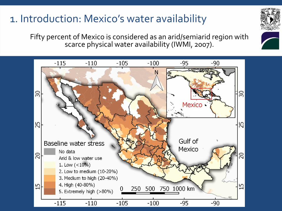
Fifty percent of Mexico is considered as an arid/semiarid region with scarce physical water availability (IWMI, 2007).
1. Introduction: Mexico’s water availability
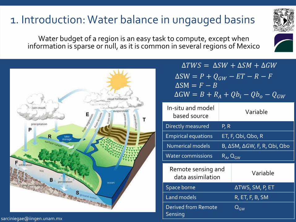
Water budget of a region is an easy task to compute, except when information is sparse or null, as it is common in several regions of Mexico
1. Introduction: Water balance in ungauged basins
∆𝑇𝑊𝑆 = ∆𝑆𝑊 + ∆𝑆𝑀 + ∆𝐺𝑊
∆SW = 𝑃 + 𝑄𝐺𝑊 − 𝐸𝑇 − 𝑅 − 𝐹 ∆SM = 𝐹 − 𝐵 ∆GW = 𝐵 + 𝑅𝐴 + 𝑄𝑏𝑖 − 𝑄𝑏𝑜 − 𝑄𝐺𝑊
In-situ and model based source
Variable
Directly measured P, R
Empirical equations ET, F, Qbi, Qbo, R
Numerical models B, ∆SM, ∆GW, F, R, Qbi, Qbo
Water commissions RA, QGW
Remote sensing and data assimilation
Variable
Space borne ∆TWS, SM, P, ET
Land models R, ET, F, B, SM
Derived from Remote Sensing
QGW

Mexico has important unconventional resources contained in 4 basins: 1)Burgos 2) Tampico-Misantla 3) Sabinas 4) Veracruz
2. Development of shale oil/gas in Mexico
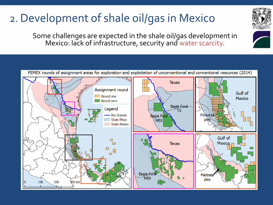
Some challenges are expected in the shale oil/gas development in Mexico: lack of infrastructure, security and water scarcity.
2. Development of shale oil/gas in Mexico

Main water budget components are derived from satellites and global hydrological models.
3. Datasets and methods
Dataset Description Extension Spatial
resolution
Temporal resolution
Time period
Reference
TRMM Tropical Rainfall Measuring Mission (TRMM) product 3B42
Global 1/4 degree Monthly 1998-2016
Huffman et al. (2010)
GRACE Gravity Recovery and Climate Experiment (GRACE) product RL05
Global 1 degree Monthly 2003-2016
Seo et al. (2006)
NOAA Rainfall and temperature derived from the interpolation of weather stations
USA and Mexico
1/16 degree Daily 1950-2013
Livneh et al. (2013)
VIC Output from Variable Infiltration Capacity model
USA and Mexico
1/16 degree Daily 1950-2013
Livneh et al. (2015)
GLDAS Global Land Data Assimilation System (GLDAS) version 2 Global 1/4 degree Monthly
1948-2009
Hualan y Hiroko (2013)
NLDAS
North American Land Data Assimilation System (NLDAS) version 2
USA and northern of
Mexico
1/8 degree Monthly 1979-2016
Robles-Morua et al.
(2012)
MODIS VI
Moderate-resolution Imaging Spectroradiometer (MODIS) Vegetation Index (VI)
Global 250 m 16 days 2001-2016
Bastiaanssen y Ali (2003)
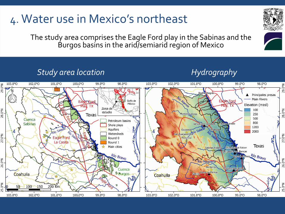
The study area comprises the Eagle Ford play in the Sabinas and the Burgos basins in the arid/semiarid region of Mexico
4. Water use in Mexico’s northeast
Study area location Hydrography
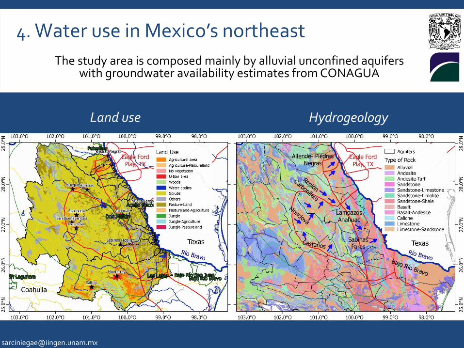
The study area is composed mainly by alluvial unconfined aquifers with groundwater availability estimates from CONAGUA
4. Water use in Mexico’s northeast
Land use Hydrogeology
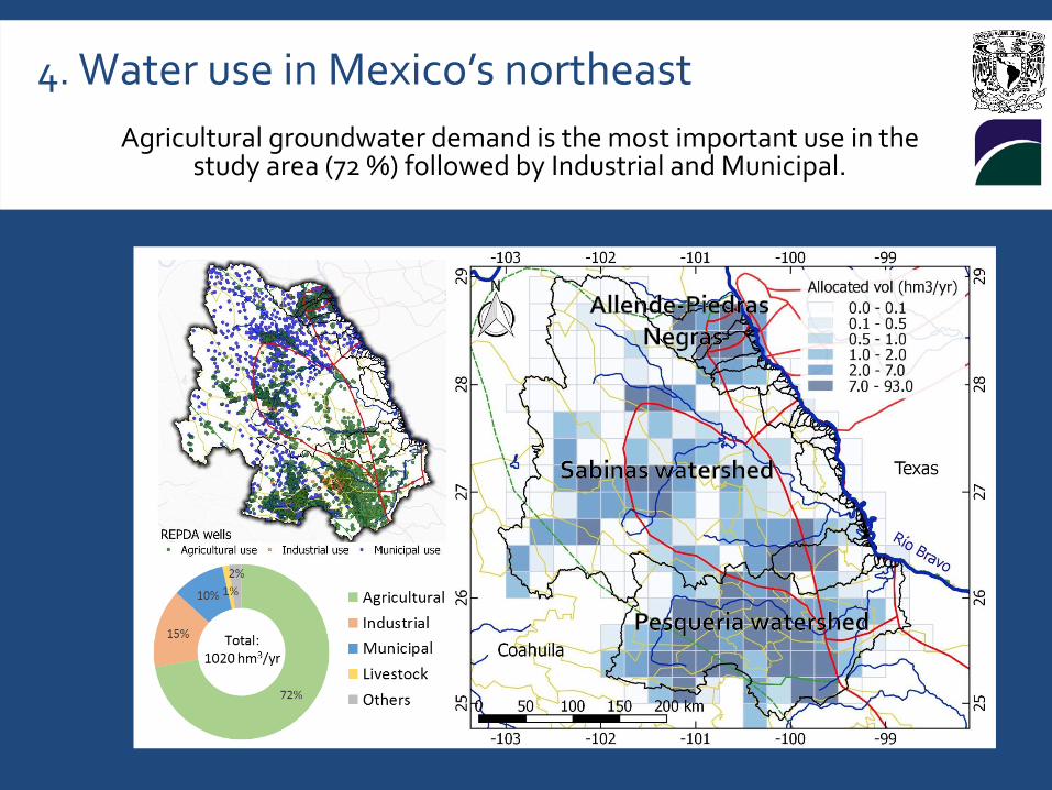
Agricultural groundwater demand is the most important use in the study area (72 %) followed by Industrial and Municipal.
4. Water use in Mexico’s northeast

Water storage changes at total study area
5. Results: Water storage change
Total Water Storage Changes
Storage Changes
Precipitation anomalies
NDVI temporal changes
Negative ∆GW on wet seasons?
∆SM> ∆TWS
Severe Drought
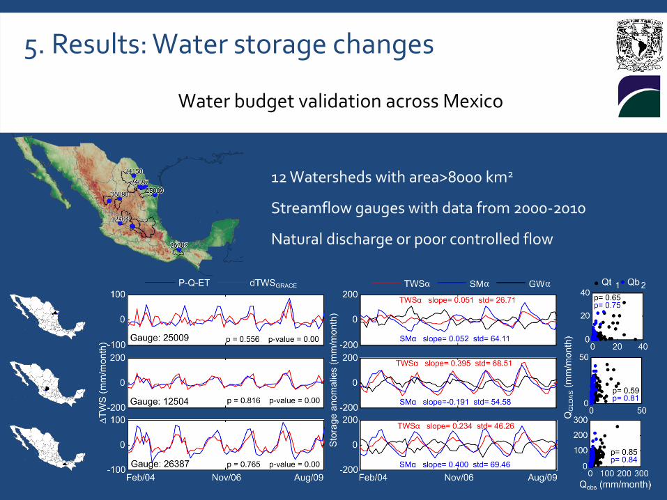
12 Watersheds with area>8000 km2
Streamflow gauges with data from 2000-2010
Natural discharge or poor controlled flow
5. Results: Water storage changes
Water budget validation across Mexico

5. Results: Products validation
Validation of results using GLDAS and GRACE datasets
Total Water Storage correlation between GLDAS and GRACE
Total Water Storage with GRACE and Soil Moisture standard deviation
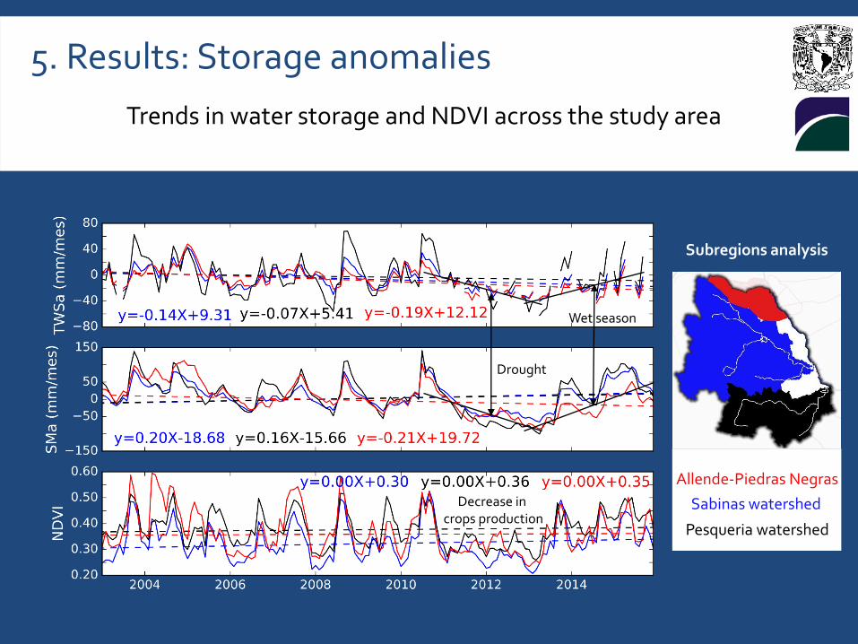
Trends in water storage and NDVI across the study area
5. Results: Storage anomalies
Sabinas watershed
Pesqueria watershed
Allende-Piedras Negras
Subregions analysis
Drought
Wet season
Decrease in crops production
Water balance estimates (GW) using remote sensing shows significant uncertainty in Mexico’s drylands due to inconsistencies between datasets (GLDAS, NLDAS, GRACE).
The study area is sensitive to Drought periods: during rainless years storages shown strong depletions and in humid years it shows a faster recovery.
The Allende-Piedras Negras aquifer shows a lower recovery capacity (TWS and SM) after a long drought period.
Historical droughts and future water demands should be considered for water management in semiarid/arid regions with potential of shale oil/gas regions to avoid conflicts between users.
5. Conclusions

Thanks
Anderson, R.G., Lo, M.H., Famiglietti, J.S. (2012). "Assessing surface water consumption using remotely-sensed groundwater, evapotranspiration, and precipitation".
EIA (2013). Technically recoverable shale oil and shale gas resources: An assessment of 137 shale formations in 41 countries outside the United States. Washington, DC.
Landerer, F.W., Swenson, S.C. (2012). "Accuracy of scaled GRACE terrestrial water storage estimates". Water Resour. Res. 48. doi:10.1029/2011WR011453
Nicot, J.-P., Scanlon, B.R. (2012). "Water use for shale gas production in Texas, U.S.". Environ. Sci. Technol. 46, 3580–3586. doi:10.1021/es204602t
Stevens, S.H., Moodhe, K.D. (2015). "Evaluation of Mexico’s Shale Oil and Gas Potential". Adv. Resour. Int. Inc. 177139, 1–13.
USGS (2014). Assessment of Unconventional Oil and Gas Resources in Northeast Mexico.
Vengosh, A., Jackson, R.B., Warner, N., Darrah, T.H., Kondash, A. (2014). "A Critical Review of the Risks to Water Resources from Shale Gas Development and Hydraulic Fracturing in the United States". Enviromental Sci. Technol. 16, 15. Geophys. Res. Lett. 39, 1–6. doi:10.1029/2012GL052400