a generic method for retrieval and validation of aerosol ... · primary convener: jean-claude...
TRANSCRIPT
A generic method for retrieval and
validation of aerosol and surface
reflectance over land: application to
Landsat 8 and Sentinel 2
Eric Vermote et al. 1NASA Goddard Space Flight Center Code 619
Landsat Science Team Meeting, July 11-13, 2017, USGS EROS, South Dakota

Home page: http://modis-sr.ltdri.org
Algorithm reference for L8: Vermote E., Justice C., Claverie M., Franch B.,
(2016) “Preliminary analysis of the performance of the Landsat 8/OLI land
surface reflectance product", Remote Sensing of Environment, 185,46-56.
The MODIS Collection 6 AC algorithm relies on
the use of very accurate (better than 1%) vector radiative transfer
modeling of the coupled atmosphere-surface system (6S)
the inversion of key atmospheric parameters
Aerosols are processed from OLI/Sentinel 2 images
Water vapor and ozone from daily MODIS product.
Landsat Science Team Meeting, July 11-13, 2017, USGS EROS, South Dakota
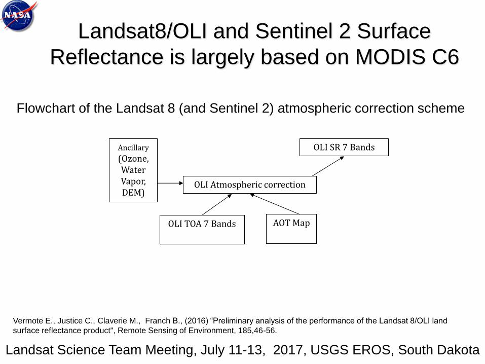
Landsat8/OLI and Sentinel 2 Surface
Reflectance is largely based on MODIS C6
(LaSRC)
Landsat8/OLI and Sentinel 2 Surface
Reflectance is largely based on MODIS C6
Landsat Science Team Meeting, July 11-13, 2017, USGS EROS, South Dakota
AOT Map OLI TOA 7 Bands
OLI SR 7 Bands
OLI Atmospheric correction
Ancillary (Ozone, Water Vapor, DEM)
Vermote E., Justice C., Claverie M., Franch B., (2016) “Preliminary analysis of the performance of the Landsat 8/OLI land
surface reflectance product", Remote Sensing of Environment, 185,46-56.
Flowchart of the Landsat 8 (and Sentinel 2) atmospheric correction scheme
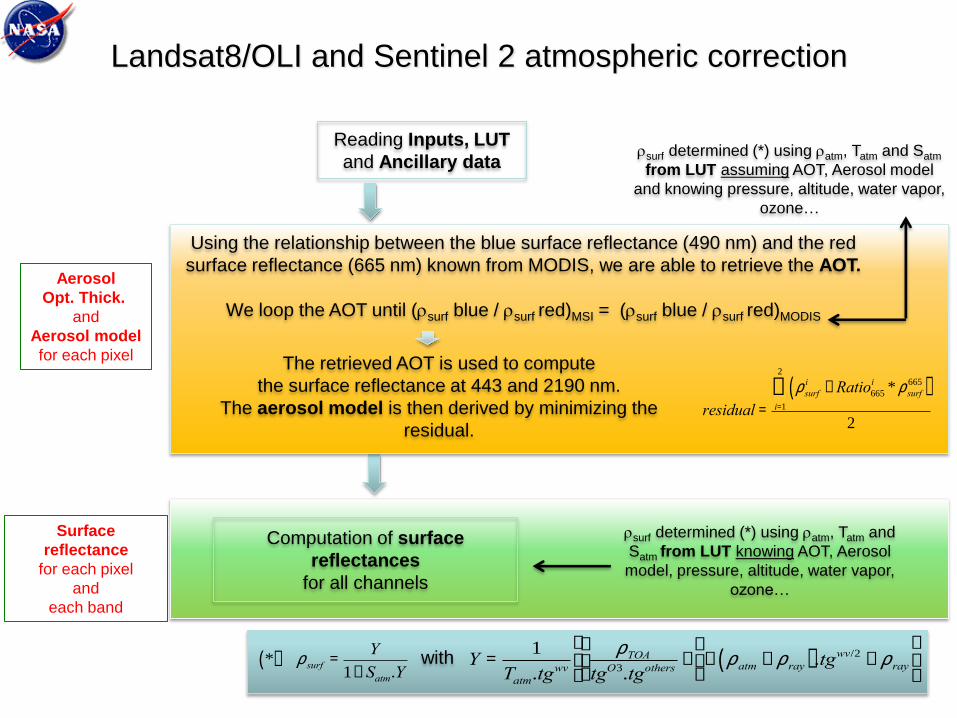
Reading Inputs, LUT
and Ancillary data
Aerosol
Opt. Thick.
and
Aerosol model
for each pixel
Surface
reflectance
for each pixel
and
each band
Using the relationship between the blue surface reflectance (490 nm) and the red
surface reflectance (665 nm) known from MODIS, we are able to retrieve the AOT.
We loop the AOT until (rsurf blue / rsurf red)MSI = (rsurf blue / rsurf red)MODIS
The retrieved AOT is used to compute
the surface reflectance at 443 and 2190 nm.
The aerosol model is then derived by minimizing the
residual. residual =
rsurfi -Ratio665
i * rsurf665( )
i=1
2
å
2
*( ) rsurf =Y
1+ Satm.YY =
1
Tatm.tgwvrTOA
tgO3.tgothers-
æ
èç
ö
ø÷- ratm - rray( ).tgwv/2 - rray
é
ëê
ù
ûúwith
rsurf determined (*) using ratm, Tatm and Satm
from LUT assuming AOT, Aerosol model
and knowing pressure, altitude, water vapor,
ozone…
rsurf determined (*) using ratm, Tatm and
Satm from LUT knowing AOT, Aerosol
model, pressure, altitude, water vapor,
ozone…
Computation of surface
reflectances
for all channels
Landsat8/OLI and Sentinel 2 atmospheric correction

Landsat Science Team Meeting, July 11-13, 2017, USGS EROS, South Dakota
CURRENT STATUS
Atmospheric correction algorithm
• L8 surface reflectance product (V3) available and
validated satisfactorily
• Sentinel 2 atmospheric correction algorithm (V2)
developed and implemented (preliminary validation
through ACIX , cloud mask needs to be implemented)

Methodology for evaluating the
performance of Landsat8/Sentinel2
Subsets of Level 1B
data processed using
the standard surface
reflectance algorithm
Reference data set
Atmospherically
corrected TOA
reflectances derived
from Level 1B subsets
Vector 6S AERONET measurements
(τaer, H2O, particle distribution
Refractive indices,sphericity)
comparison
Landsat Science Team Meeting, July 11-13, 2017, USGS EROS, South Dakota
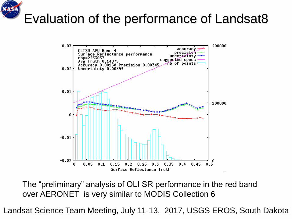
The “preliminary” analysis of OLI SR performance in the red band
over AERONET is very similar to MODIS Collection 6
Landsat Science Team Meeting, July 11-13, 2017, USGS EROS, South Dakota
Evaluation of the performance of Landsat8
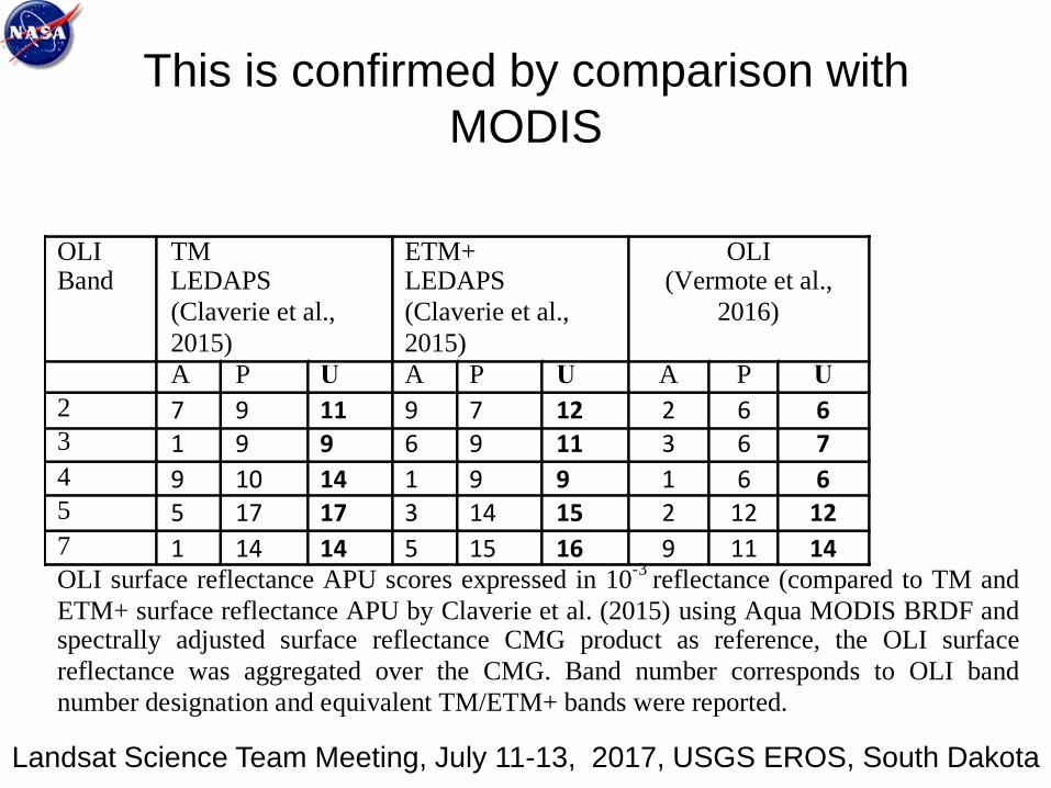
This is confirmed by comparison with
MODIS
OLI Band
TM LEDAPS
(Claverie et al.,
2015)
ETM+ LEDAPS
(Claverie et al.,
2015)
OLI (Vermote et al.,
2016)
A P U A P U A P U
2 7 9 11 9 7 12 2 6 63 1 9 9 6 9 11 3 6 74 9 10 14 1 9 9 1 6 65 5 17 17 3 14 15 2 12 127 1 14 14 5 15 16 9 11 14OLI surface reflectance APU scores expressed in 10
-3 reflectance (compared to TM and
ETM+ surface reflectance APU by Claverie et al. (2015) using Aqua MODIS BRDF and spectrally adjusted surface reflectance CMG product as reference, the OLI surface
reflectance was aggregated over the CMG. Band number corresponds to OLI band
number designation and equivalent TM/ETM+ bands were reported.
Landsat Science Team Meeting, July 11-13, 2017, USGS EROS, South Dakota

Landsat Science Team Meeting, July 11-13, 2017, USGS EROS, South Dakota
* 1st Workshop in June 21st-22nd 2016 @ University of Maryland: to elaborate
concepts, protocols and guidelines for the inter-comparison and validation of SR products
• 2nd workshop in April 2017
• Results to be finalized in fall 2017
ACIX: CEOS-WGCV Atmospheric Correction
Inter-comparison Exercise
(ESA/NASA/UMD)
The exercise aims to bring together available AC processors (actually 14
processors including SEN2COR, MACCS, L8-S2-6SAC, …) to generate the
corresponding SR products.
The input data will be Landsat-8 and Sentinel-2 imagery of various test sites,
i.e. coastal, agricultural, forest, snow/artic areas and deserts.
Objectives
To better understand uncertainties and issues on L8 and S2 AC products
To propose further improvements of the future AC schemes
https://earth.esa.int/web/sppa/meetings-workshops/acix
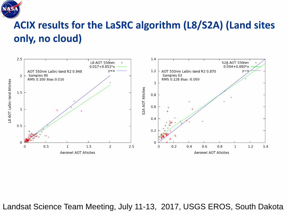
ACIX results for the LaSRC algorithm (L8/S2A) (Land sites only, no cloud)
Landsat Science Team Meeting, July 11-13, 2017, USGS EROS, South Dakota

ACIX results for the MODIS SR algorithm (L8/S2A) (Land sites only, no cloud)
Landsat Science Team Meeting, July 11-13, 2017, USGS EROS, South Dakota
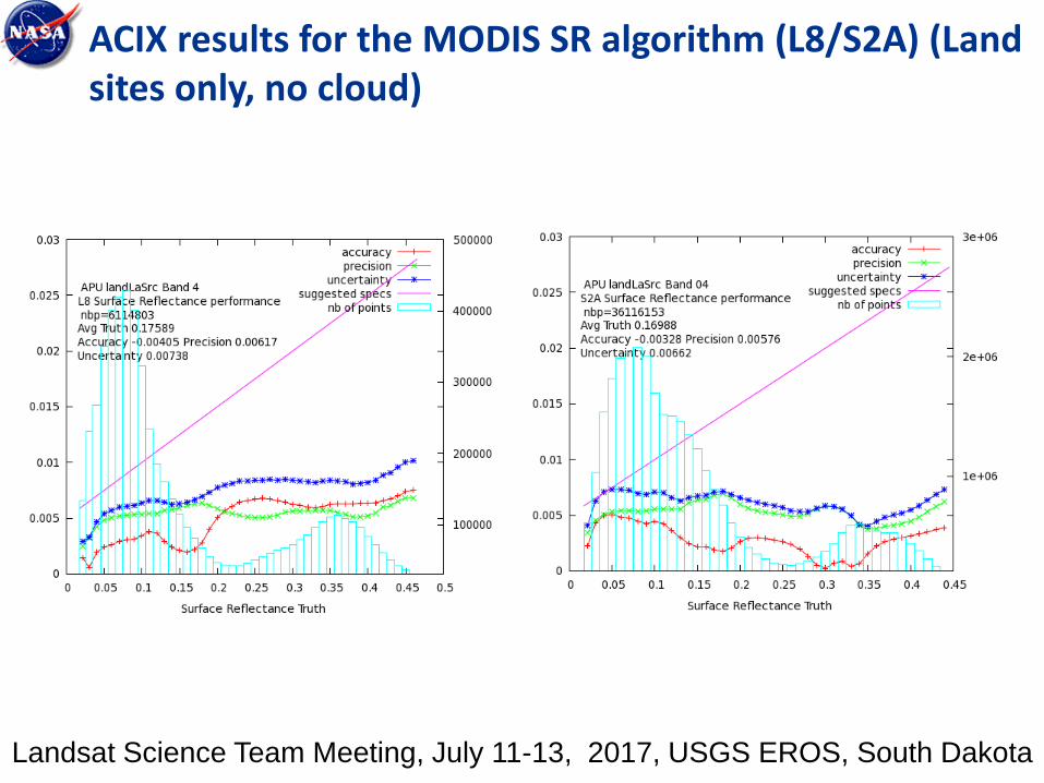
ACIX results for the MODIS SR algorithm (L8/S2A) (Land sites only, no cloud)
Landsat Science Team Meeting, July 11-13, 2017, USGS EROS, South Dakota
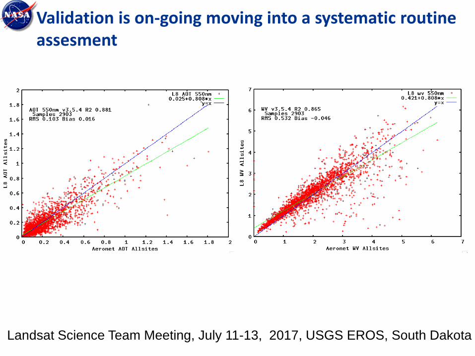
Validation is on-going moving into a systematic routine assesment
Landsat Science Team Meeting, July 11-13, 2017, USGS EROS, South Dakota

Landsat Science Team Meeting, July 11-13, 2017, USGS EROS, South Dakota
NDVI aggregated at field level (Argentina, S2A tile 20HNH).
Sentinel-2A image acquired on 04-Dec-15, 10m,
true color B04-03-02 (SR, scaled 0-0.15)
Landsat-8 image acquired on 04-Dec-15,
30m, true color B4-3-2 (SR, scaled 0-0.15)
MOD09GQ image acquired on 04-Dec-15,
250m, false color B2-1-1, SR
Temporal information is now available at the
field level
Sentinel-2A image acquired on 23-Jan-16, 10m,
true color B04-03-02 (SR, scaled 0-0.15)
Landsat-8 image acquired on 21-Jan-16,
30m, true color B4-3-2 (SR, scaled 0-0.15)

Landsat Science Team Meeting, July 11-13, 2017, USGS EROS, South Dakota
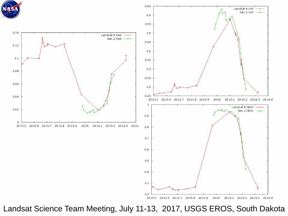
NDVI aggregated at field level (Argentina, S2A tile 20HNH).
LC8 acquired on 15-Sep-2015 (30m). SR
NIR band scaled 0.05-0.55
MODIS/Terra (MOD09GQ) acquired on
15-Sep-2015 (250 m). SR NIR band
scaled 0.05-0.55
MODIS/Terra (MOD09GQ) acquired on
16-Sep-2015 (250 m). SR NIR band
scaled 0.05-0.55
Maize
Temporal information is now available at the
field level
Landsat Science Team Meeting, July 11-13, 2017, USGS EROS, South Dakota
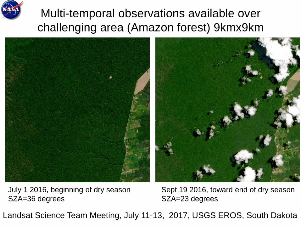
Multi-temporal observations available over
challenging area (Amazon forest) 9kmx9km
Landsat Science Team Meeting, July 11-13, 2017, USGS EROS, South Dakota
July 1 2016, beginning of dry season
SZA=36 degrees
Sept 19 2016, toward end of dry season
SZA=23 degrees
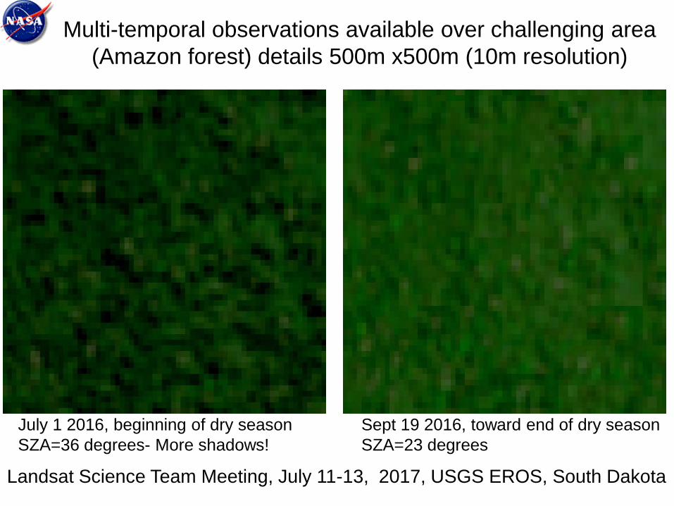
Multi-temporal observations available over challenging area
(Amazon forest) details 500m x500m (10m resolution)
Landsat Science Team Meeting, July 11-13, 2017, USGS EROS, South Dakota
July 1 2016, beginning of dry season
SZA=36 degrees- More shadows!
Sept 19 2016, toward end of dry season
SZA=23 degrees

Conclusions • Surface reflectance code (LaSRC) is mature and pathway
toward validation and automated QA is clearly identified.
• Algorithm is generic and tied to documented validated
radiative transfer code so the accuracy is traceable enabling
error budget.
• The use of BRDF correction enables easy cross-comparison
of different sensors (MODIS,VIIRS,AVHRR, LDCM, Landsat,
Sentinel 2 ,Sentinel 3…)
• Preliminary Sentinel 2 surface reflectance validation shows
good performance but needs a more extensive study
Landsat Science Team Meeting, July 11-13, 2017, USGS EROS, South Dakota

Landsat Science Team Meeting, July 11-13, 2017, USGS EROS, South Dakota
Satellite Land Surface Reflectance at Medium/High Resolution: Algorithms, Validation and Applications
Session ID#: 26260
Session Link: https://agu.confex.com/agu/fm17/preliminaryview.cgi/Session26260
Session Description:
We solicit papers on the inversion and use of reflectance products from Landsat(s) and Sentinel 2 sensors with
other sensors. For the last years, medium and high resolutions became a useful and a powerful toll for Earth
studies. Topics of interest mainly include (not limited to):
•Algorithm description and validation (including Cloud screening, Aerosol inversion, Radiative transfer);
•Use of products in agricultural monitoring applications (such as crop area, crop type, crop growing, yield
estimation and prediction, damage assessment);
•Data integration / Harmonized products from both sensors with others;
•Theoretical studies for sensors capabilities enhancements (e.g. addition of spectral bands) to future sensors for
agriculture application;
•Development and use of new vegetation indices (i.e. red edge) and other products for agriculture applications.
Primary Convener: Jean-Claude Roger, University of Maryland College Park, Department of Geographical
Sciences, College Park, MD, United States
Conveners: Eric Vermote, NASA Goddard Space Flight Center, Greenbelt, MD, United States, Shinichi
Sobue, JAXA Japan Aerospace Exploration Agency, Sagamihara, Japan and Ferran Gascon, European Space
Research Institute, Frascati, Italy
Index Terms:
0416 Biogeophysics [BIOGEOSCIENCES]