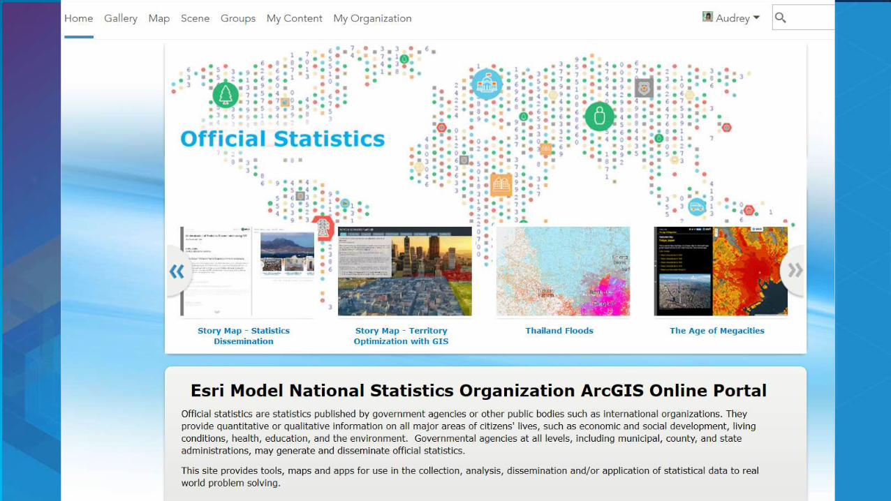
a geographic platform for data across society - unsd 3... · design form in excel . data processing...
TRANSCRIPT

A Geographic Platform for Data Across Society From Community to Global

Integrating Existing Systems . . .
. . . Creating a System of Systems
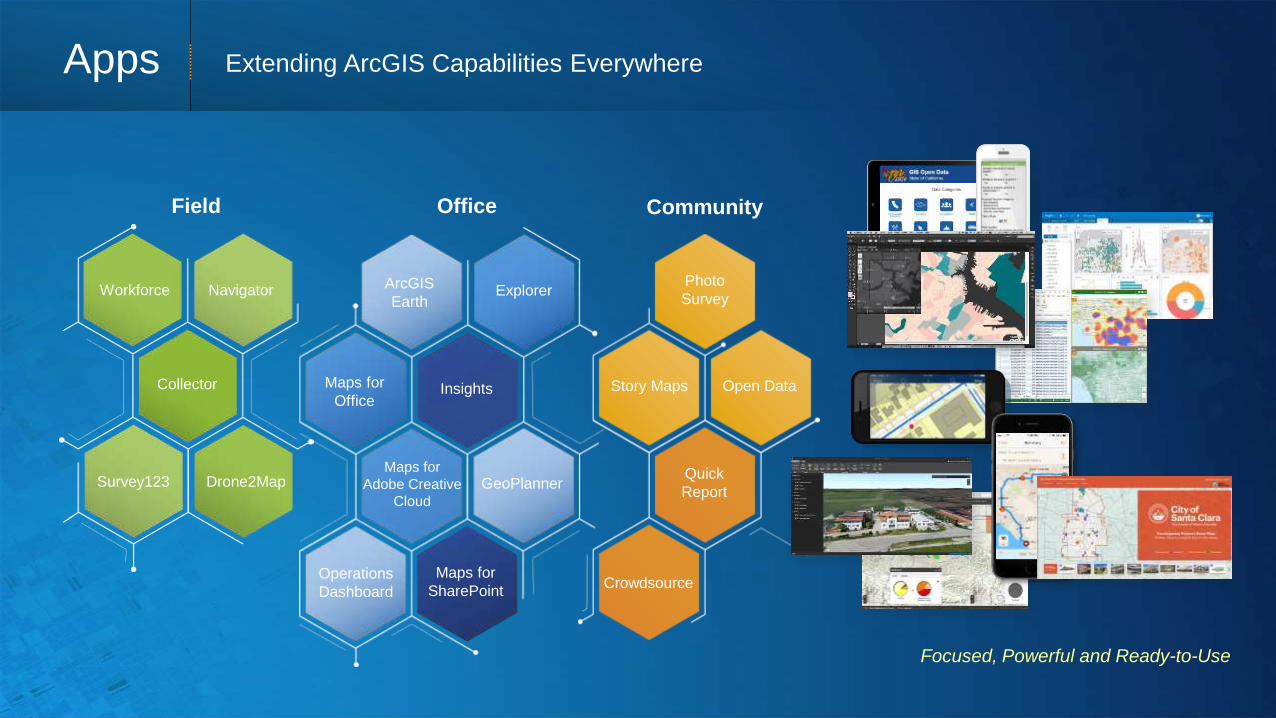
Apps
Desktop
Server
Identity
Real-Time Systems of Record
System of Engagement
Connected
Services
Web GIS is Transforming GIS Opening, Integrating and Simplifying Everything

Creating a System of Engagement
Analytics &
Dissemination
Reporting (Dashboards)
Mapping and
Visualization
Work Force /
Operations
Management
Data Processing &
Management Data Collection /
Updating
GIS for Official Statistics System of Record

Creating a System of Engagement
Data Processing &
Management
Collector/ Survey123/ Drone2Map
Workforce
Web Map Viewer
Dashboard
Smart Mapping
Data Model
• Administrative Boundaries
• Enumeration Area Boundaries
• Transportation Network
• Rivers and Water Features
• Worker Locations
• Populations/Counts
• …
GIS for Official Statistics System of Record

Form-centric Data Collection
Survey123 for ArcGIS
Works Offline
Smart Forms

Survey123 for ArcGIS
Works Offline
Design form in
Excel
Data Processing &
Management
Story Maps
Analytics
Dashboards
Open Data
SDG Hub
System of Engagement | Applications and Tools

Data Processing &
Management
Story Maps
Analytics
Dashboards
Open Data
SDG Hub
System of Engagement | Applications and Tools

Improving
• Efficiency
• Collaboration
• Communication
Smart GIS Integrates Everything Connecting People, Processes, Things and Data About Them
System of
Insight
System of
Engagement
System of
Record
Supports Multiple
Types of Systems
Helping Organizations
Understand . . .
. . . and Be Aware, Alert,
and Responsive

City GIS
Smart GIS Engages Communities “Community GIS” Is a New Pattern
Enabling Smart Communities . . .
Journalists
Civic Organizations
Citizens
NGOs
Startups
Schools
Providing a Platform for
Civic Engagement . . .
Civic Hackers Open Data

Apps
Web GIS Architecture
Client / Server Web Services & App
Stand Alone Desktop Connected Desktop
Data Models Web Maps
Static Data Real-Time
Custom Applications Configurable Templates and Apps
All Purpose Applications Focused Apps
Proprietary Data Open Data & Shared Services
Distributed Services
Shifts the Focus

City of Los Angeles Is Already Implementing a Community GIS

Expanding Their GIS to Support Everyone
COMMUNITY LEADERS
CITY STAFF
START-UPS
CITIZENS & NGOs
SCHOOLS
CITY LEADERS


The Goals
SDG HUB
SDG Hub No one is left behind
City Leaders
NGOs
Academia
Start Ups
Private Sector
Community Leaders

Thousands of Maps and Layers
Ready-to-Use
Authoritative
Online Content A Living Atlas of the World
Millions of User Contributions . . . Billions of Views per Week
Basemaps | Imagery | Demographics | Landscape
Tens of Thousands of
Open Data Sets

Advancing the Science of Geography
Aggregation
Hot Spots
Charting
Mode-Specific Routing
Statistical Clustering
Web Browser Desktop
Interpolation Anomaly Detection
Living Atlas Integration
New Raster Functions
Bayesian Regression (EBK)
Scientific Data Support
Faster Geocoding (230+%)
Location Allocation
Buffer
Spatial Analysis Providing Insights and Understanding
Integrating Analysis Tools
Data Exploration
Open Data
Photo
Survey
Quick
Report
Crowdsource
Story Maps
Focused, Powerful and Ready-to-Use
1
Collector
Drone2Map
Workforce
Survey123
Navigator
Field
Maps for
Office
GeoPlanner
Operations
Dashboard
Maps for
SharePoint
Insights
Explorer ArcGIS
Earth
Maps for
Adobe Creative
Cloud
Office Community
Apps Extending ArcGIS Capabilities Everywhere

Delivering Innovation & Best Practices
Public Safety &
Emergency
Management
Utilities & Telecom
Local & State Government
Military &
Security
500,000+ Downloads
Open-Source
Solutions
Open-Source Maps & Apps Hundreds of Ready-to-Use Solutions
Emergency
Management
Utilities &
Telecom
Local
Government
Military &
Security
Provincial/
State
Government
• Easily Configurable
• Fully Supported
• No Cost

Providing Massively Parallel Processing
. . . Creating New Insights
Parallelized Analytics on Vector and Raster Data
Lightning Strikes
Spatiotemporal Analysis
Big Data GeoAnalytics and Visualization of Massive Data
Solar Suitability
GeoAnalytics
Server
Image
Server

Insights App
• New Paradigm (Visual, Intuitive, Responsive)
• Dynamic Analysis
• Very Fast Data Access
Extending and Complementing Traditional Analysis
Transforming Understanding with Interactive Analysis
Linked and Responsive Charts and Maps
On-The-Fly Visual Models
Integrated Spatial and Tabular Analysis
Insights
Coming Later
This Year…

To teach the World Data community how to
leverage the GIS platform capabilities.

http://www.esri.com/mooc
http://www.esri.com/mooc

The Goals
SDG HUB
A Geographic Platform for Data Across Society No one is left behind
City Leaders
NGOs
Academia
Start Ups
Private Sector
Community Leaders
