a guide to teaching earth system science - nasa - er · pdf fileour mission to planet...
TRANSCRIPT

A Guide to Teaching Earth System Science
OU
R
MISSION TO PLANET EARTHEducational Product
Teachers Grades K-4
National Aeronautics andSpace Administration

Our Mission to Planet Earth—A Guide to TeachingEarth System Science is available in electronic formatthrough NASA Spacelink—one of the Agency's elec-tronic resources specifically developed for use by theeducational community.
The system may be accessed at the following address:http://spacelink.nasa.gov

OUR MISSION TO PLANET EARTHA Guide to Teaching Earth System Science
This publication is in the Public Domain and is not protected by copyright. Permission is not required for duplication.
National Aeronautics and Space AdministrationOffice of Mission to Planet Earth
Office of Human Resources and EducationEducation Division
EP-1997-12-292-HQ

Acknowledgments
Julia BerrySt. Patrick’s Episcopal SchoolWashington, DC
Elizabeth Fucella BurgosAbingdon Elementary SchoolArlington, VA
Shelley NovacoRidgecrest Elementary SchoolChillum, MD
Don PetersenWillow Springs SchoolFairfax, VA
Margaret LongoMill Creek Towne Elementary SchoolDerwood, MD
Irene MorrisStevens Elementary SchoolWashington, DC
NASA wishes to express its deep appreciation and gratitude to the teachers who helped inreviewing and developing “Our Mission to Planet Earth.”

Table of Contents
Introduction A Guide to Teaching Earth System Science ...............................................1
Unit 1 Demonstrating the View from Space.........................................................5Earth From Energy ......................................................................................................6Space Creating an Earth System Model ...............................................................7
Systems ....................................................................................................8
Unit 2 Cycles: How Earth's Components Interact within the System .................11Forces of Water Cycle............................................................................................12 Change Water Cycle Changes .............................................................................14
Unit 3 Global Environmental Impacts................................................................17Global Change Land-use Changes: Deserts .....................................................................18
Greenhouse Effect: Global Warming.......................................................19Global Cooling.......................................................................................21
Unit 4 Satellites: Observing the Whole Earth ....................................................23Mission to Satellites .................................................................................................26Planet Earth Instruments.............................................................................................26
Satellite Design.......................................................................................26Data .......................................................................................................27Modeling................................................................................................27Careers ...................................................................................................30
NASA Resources for Educators ...............................................................................................................33

Volcanic eruptions, hurricanes, floods, and El Niño are naturally occurringevents over which humans have no control. But can human activities causeadditional environmental change? Can scientists predict the global impactsof increased levels of pollutants in the atmosphere? Will the planet warmbecause increased levels of greenhouse gases, produced by the burning offossil fuels, trap heat and prevent it from being radiated back into space?Will the polar ice caps melt, causing massive coastal flooding? Havehumans initiated wholesale climatic change?
These are difficult questions, with grave implications. Predicting globalchange and understanding the relationships among Earth’s componentshave become a priority for the nation. The National Aeronautics and SpaceAdministration (NASA), along with many other government agencies, has ini-tiated long-term studies of Earth’s atmosphere, oceans, and land masses usingobservations from satellite-, balloon-, and aircraft-borne instruments. NASAcalls its research program Mission to Planet Earth. Because NASA can placescientific instruments far above Earth’s surface, the program allows scientiststo explore Earth’s components and their interactions on a global scale.
Although this program will never answer all the questions, NASA realizesthat understanding the planet will not happen by examining pieces one at a time; it will take teams of biologists, physicists, chemists, and geologistsworking together to fully understand Earth as a system. Earth Science, inshort, must be an interdisciplinary challenge. The scope of Earth Science is sometimes limited to the study of geology and some closely allied fields,such as oceanography. The Mission to Planet Earth calls for an interdiscipli-nary approach including biology, chemistry, and physics.
1
OUR MISSION TO PLANET EARTHA Guide to Teaching Earth System Science
Introduction
Earth as a System
This leads to why NASA initiated the development of “Our Mission toPlanet Earth: A Guide to Teaching Earth System Science.” The children inyour classrooms today could become the scientists of tomorrow who willanalyze the data streaming back to Earth via satellite communications.NASA will look to their generation for talent. Consequently, children’sexposure to the concept of Earth as a system cannot begin too early. Even ifyour students do not pursue careers in Earth Science, they must understandEarth System Science. They could face the challenge of trying to adapt toglobal climate change.
This teacher’s guide is not meant to replace the existing curricula of yourlocal school jurisdiction, but rather to augment it. The primary goal is forchildren to become familiar with the concept of cycles, defined as a processthat repeats itself in the same order, and to learn that some human activitiescan cause changes in their environment.
It is assumed in this guide that children are already studying the basics ofEarth Science. They have learned about the planet’s primary components—its land, air, and water, and understand the role of the Sun in providing uswith energy. Although the guide addresses Earth’s components, it does sofrom the perspective of space to show the planet as a large system, withinteracting parts. To demonstrate on a much smaller scale how these partswork together, children are asked to build their own Earth system, a terrari-um, which will be used for experimentation throughout the guide. Forinstance, your students observe how water evaporates due to the Sun’s radi-ation and eventually condenses to form clouds. They are exposed to therelationship between land and water, and the topographical changes due toerosion. Through experimentation with the terrarium, they learn about theimpact of global change on the system.
After completing these lessons, they learn how scientists use satellite tech-nology to examine the entire planet as a whole to study global climate—thebasics of NASA’s Mission to Planet Earth program. They create their ownmodels of instruments and satellites and learn about careers in Earth SystemScience. Although some younger children may understand these concepts,the activities are geared primarily to second and third graders. For kinder-garten and first grade teachers, however, this should not preclude you fromincorporating some of the activities into your lessons.
2
Cycles andChange

“Our Mission to Planet Earth” is designed to reinforce basic skills. Throughhands-on activities, experiments, and discussions, students practice how toidentify, classify, organize, and recall information. They become familiarwith new vocabulary. You are encouraged to create any type of scenario—pretending, for instance, that students are Earth scientists—to make thelessons come to life. Above all, the program is aimed at allowing youngerpeople to recognize themselves as part of the Earth system.
For NASA, the challenge has been to develop a package that makes inte-grated Earth Science compelling, understandable, and interesting to youngminds. NASA has a vested interest. The agency, after all, is depending onyour students to become the engineers, scientists, and technicians of tomor-row, those who will build the next generation of satellites or interpret thedata and inform leaders of responsible environmental policies. While manyof your students will pursue other roles in society, an understanding of theEarth system is still important. They could face the more daunting, long-term challenge of trying to control or adapt to global climate change.
Our Mission to Planet Earth includes a teacher’s guide and a set of sevenlithographs designed to illustrate key lessons in the package. AlthoughNASA has recommended specific lithographs for each unit (see “Visuals”selection of each unit), you may use other visuals to augment the lessons.Photographs found in magazines, newspapers and other sources work well,as do posters and slides.
3
Tomorrow’sScientists,Engineers, and Technicians

4

Photographs of Earth taken from space show that our planet is a single sys-tem. When students observe Earth from this perspective, they can readilysee oceans, clouds, and continents that are lit by sunlight, the energy thatsupports life on Earth. We do not know of any other planet that has waterand an atmosphere like Earth’s. (However, the components alone—solids,liquids, gases—without continuous changes in temperature, composition,and chemistry, might not support life as we know it.) To understand the waythe Earth system works, students first must learn what these components areand then examine ways that they interact and change. To do this, they willbuild terrariums as models of Earth. Throughout these four units, studentswill learn how scientists study Earth’s system to understand human-inducedand natural changes.
Students will be able to:
• Identify in photographs Earth’s components from space: water (oceans, bays, rivers), land (continents), and air (atmosphere).
• Find the atmosphere in a photograph showing the limb (curved edge) of Earth.
• Identify the Sun as the source of energy and life on Earth.• Recognize that different-colored components absorb and reflect
sunlight differently.
• NASA Lithograph: View of Earth• NASA Lithograph: Water is a Force of Change• NASA Lithograph: TOPEX/Poseidon. Photo of Earth limb from space
showing Earth’s atmosphere.
5
EARTH FR M SPACEDemonstrating the View from Space
Introduction
Objectives
Visuals
Unit 1

Absorb Heat River
Atmosphere Land Soil
Cloud Ocean Sunlight
Continent Oxygen Surface
Earth Reflect Terrarium
Demonstrating the View from Space.
Films, videos, and photos: Show aerial and space views of Earth to helpstudents understand that the air, land, and water seen in the photo are thesame as those seen from the ground; they just are seen from a different per-spective. Ask students who have flown in airplanes or climbed to the top oftall mountains to describe what they saw. Point to the U.S. in the photo ofEarth from Space. If they are not familiar with the U.S. map, explain thatlarge areas of land are visible from space and that it would take many hoursto drive by car from one area to another. Use common local trips to helpyour students relate to distances.
The Sun’s radiation is the source of energy for the Earth system. The heatand light allow plants and animals to thrive. The radiation also supplies theenergy for many of the cycles among the atmosphere, oceans, and land.Air, land, and water absorb or reflect energy differently, affecting weatherpatterns, ocean currents, winds, and temperatures. Deserts and cloudsreflect a great deal of energy, while ocean surfaces and forests reflect less.The warming of Earth’s atmosphere moderates the temperatures around theglobe making it inhabitable by living things.
6
Vocabulary
Activities
BALTIMORE
ANNAPOLIS
WASHINGTOND.C.
MA
RY
LA
ND
CHESAPEAKE BAY
Energy

White sand, black potting soil, and light grey gravel, three thermometers,three clear glass bowls. (Many heat-resistant, hard, fine-grained pottingmaterials could work.) Be sure to use one white and one black for contrastin absoption of energy.
Demonstrating Absorption of Solar Energy.
To demonstrate the effects of solar energy on our planet, students mustlearn that components of the Earth system absorb sunlight differently.Place sand, gravel,and soil in each of the three glass bowls and insert oneof the thermometers just below the surface of each material. Leave thecontainers in sunlight for several hours. White sand represents the cloudsand snow; black soil, the land (forest, green grass); and grey, the ocean ordead grass. Ask the students to compare the temperatures to see how thedifferently colored materials absorb heat.
Under which materials would you put ice if you wanted it to melt faster? Try it.
Lighter colors reflect more light (stay cooler); darker colors absorb morelight (get warmer). Clean white surfaces, like snow, reflect about 90% of thelight hitting them. City snow-removal crews could put dark soil on piles ofsnow when they want the snow to melt faster.
Students should build a small Earth environment to understand that thecomponents fit together, and that they interact and change. Students maycreate a terrarium using animals and plants. Include a pond in the terrari-um. The terrarium could show land, air, water, and energy. The easiestmethod to control the conditions during the experiments found in the nexttwo lessons is to build one large group terrarium and several small ones (up to six). Some students may choose to pick a particular environment.One student team might work with sandy soil and cactuses, for example,and another might fill an aquarium with tadpoles and pond plants.
Extra Activity
Observation
Materials
Creating an Earth System Model
Introduction
7

Terrarium. Potting soil, gravel, activated charcoal, sand, clay, rocks, andsmall plants. Rectangular glass tank, watering can with a thermometerinside. Small glass bowl to sink in the soil as a pond. Small plastic toysloaned by the students. Optional occupants: salamanders, newts, turtles,insects, frogs, or fish. (Fish will die in a little bowl; each one requires at leastone gallon of water, which needs to be changed regularly.) Laws govern thecapture and handling of wildlife, so check with your state, city, or federalauthorities. Several of these animals can be purchased from pet stores for aslittle as five dollars.
Aquarium System Terrarium
A “system” is a group of elements that interact and function together as awhole. To help students understand the complexity of a “system,” discussother systems found in their immediate environment. School, neighborhoods,families, and local public transportation services all can be classified as systems.Second, to help students recognize the impact of change, ask studentswhether those systems ever malfunctioned. Was the bus late? Do largesnowstorms sometimes close school? Tell them that to understand how thesystem works, they are going to construct their own model of an Earth system.Later, when all the components are in the terrariums, the students can con-duct experiments to observe how the components interact with each other.
How to building the model Earth system, with several approaches to con-struction. Students should build an unsealed terrarium (open system) unlessthe teacher has experience with closed-system terrariums.
8
Vocabulary
Systems
Activity
Bowl/Pond
2-5” soil
~1/4”charcoal
1-11/2” gravel
Soils
Materials

Terrariums or aquariums would work best in a class that has time to watchliving things grow. A version built by the whole group might be better suitedto K and Grade 1, while team or individually built versions would workwell for Grades 2 or 3. To conduct the terrarium experiments foundthroughout the guide, classes will need at least six jar-size terrariums. Do not use terrariums containing live animals in any of the experiments.Some of the experiments could harm the animals.
Terrarium: Part 1, Setting up the Terrariums.
(A follow-up to this experiment will be conducted in subsequent lessons.)
Use one of the terrariums or separate containers. Set up an experimentmonitoring plant growth and plant appearance in which frequency of water-ing, water temperature, exposure to fresh air, soil, and light at the start are asconstant as possible. Select plants with different light or water requirementsand establish if they thrive under these starting conditions. Select rapid-growing grasses or flowers and slow-growing cactuses, succulents, ferns,etc. Note their condition and growth on a chart (see model, page 10) or innotebooks. Later, students will experiment with the terrariums by alteringone of the components, either exposure to light or frequency of watering, tosee how changes affect the various types of plants. To teach the activity as amore controlled experiment, set up two identical containers for each plantvariety. Allow a few days for them to stabilize, then use one as the controland one as the experimental mini-terrarium.
9
Observation

10
Type of Plant Terrarium Observation Chart
Hou
rs o
f Lig
htEx
posu
reFr
eque
ncy
ofW
ater
ing
Roo
m
Tem
pera
ture
Soil
Type

Cycles: How Earth’s Components Interact within the System
A demonstration of the water cycle using a terrarium is an ideal model foryour class to observe changes that occur in the Earth system. Looking at thewhole planet, cycles include events occurring over very large areas andlong periods of time, so they are difficult to see from the surface. In the“model Earth,” events can cause immediate and dramatic changes. Thenext two units use the water cycle and the effects of erosion and drought to demonstrate the principle of cycles in the Earth system.
Cycles, like the seasons, are a natural occurrence on Earth. Earth’s cyclesprovide a balance to which people and nature have adapted. The watercycle spreads life-giving water and minerals within local regions andaround the world.
Students will be able to:
• Recognize that because air, land, and water absorb and reflect sunlight differently, they all affect the water cycle.
• Document in a notebook or on a group-produced chart a “scientific investigation” using the terrarium. Observe, measure, and make predic-tions about changes to the components of the terrariums.
• Name the parts of a water cycle on Earth and in the terrarium: water, evaporation by the Sun, clouds, rain or snow (precipitation), rivers, lakes, oceans and ice, etc.
• Describe what happens to the soil and the plants in the terrarium when they has too much water (flood).
• Predict how too much rain might affect soils and plants on Earth.• Describe what happens to the soil and the plants when they get sunlight
but too little water (drought).
11
F RCES OF CHANGE
Introduction
Objectives
Unit 2

NASA Lithograph: Water is a Force of Change
Cycles Erosion Moisture
Dissolve Evaporation Precipitation
Drought Global Change Water Cycle
A cycle is a sequence of events that repeats itself, such as the seasonal cycle:summer, fall, winter, and spring. In the Earth system, the same componentsinteract repeatedly; the water cycle is a good example. Sunlight evaporateswater; the moisture rises into the atmosphere, where it condenses as clouds.When the warm, moisture-laden clouds meet colder air, the temperaturedrop makes the water vapor precipitate and fall to Earth as rain or snow.On land, water soaks into the ground or flows to the oceans and lakes bystreams and rivers. This water is redistributed across Earth as water vapor,clouds, and rivers or snow and ice.
WaterCycle
12
Visuals
Vocabulary
Ocean
Ground Water
Lake

Demonstrating the Water Cycle.
Glass or plastic to cover the terrarium, bowl or mirror, wet towel, household iron.
Terrarium: Part 2, Demonstrating the Water Cycle: Catch a Cloud.
Cover the terrarium and observe how moisture collects on the glass anddrips down the sides of the terrarium. Ask the students to guess why thishappens. You can also generate water vapor by ironing a towel or boilingwater in a covered pot. Either can represent the Sun heating Earth. Hold aglass bowl or large mirror over the rising steam and “catch a cloud.”
Demonstrating Evaporation.
Demonstrate evaporation of water from a puddle. On a sunny day, pour acup of water on the sidewalk. Have students draw a circle around theperimeter with chalk. Tell them to come back in 30 minutes to see the pud-dle. Create a smaller puddle indoors by putting drops of water on a bakingsheet. Use a hair dryer on the puddle to represent a warm, windy day whenthe Sun is shining. Ask them where the water went and why.
Terrarium as a System.
Record information about the terrarium experiment on a wall chart or inindividual notebooks. Draw pictures of the different plant species bothbefore and after conditions are changed.
Terrarium: Part 3, Changes to the System.
Continue to track the conditions of the plants in a terrarium. To make theterrarium climate more like Earth’s, change one of the conditions (eitherprovide more or less water or reduce or increase the exposure to light).Monitor each of the plants’ growth under this new condition. Studentsshould note all changes to the plants and how much water and sunlightthey received. Plants grow long and weak and lose some of their color ifthey need more light, or they wilt and dry out when they need more water.
13
Activities
Materials
Observations

Living things are highly dependent on the water cycle. Some creatures liv-ing in lakes, rivers, or streams will be affected if water levels rise or fall. Toolittle rain, which results in a drought, can weaken or kill plants, thus reducingfood for animals. People and animals can migrate to food and water, but ifthe drought continues or spreads, eventually they will die.
Too much snow or rain, on the other hand, can drown plants or createfloods that wash away land (plant and animal habitats) and flush pesticidesand industrial chemicals into rivers. With flooding, erosion sometimesoccurs. While erosion is a natural process, careless practices by humanscan cause loss of valuable topsoil and contribute to the spreading of desertsin the world.
Terrarium: Part 4, Demonstrating Erosion.
Use the terrarium as a model of Earth to demonstrate how water can carrymaterials from one place to another through erosion of soils or dissolutionof minerals.
One of the terrariums, or empty jar and soil; source of tap water; bag of salt;paper cups.
Demonstrate by pouring water onto the terrarium soil how land erodes anddestroys vegetation. The water will wash soil into the terrarium pond andmake it cloudy. Particles of dirt, sand, and small pebbles are suspended inthe water as a mixture. If the students did not build a terrarium, mix dirtwith water in a jar and stir to show how the particles are suspended whenthe water is moving. You could create a canyon on a baking sheet. Fill ashallow pan with soil. To slowly pour water on the soil, poke a hole in theside of a Styrofoam cup half an inch from the bottom. Set the pan at a lowangle. At the high end set the cup and fill it with water. The water will trickleout and make a small canyon in the pan.
14
Observation
Materials
Mixing
WaterCycleChanges

Water can dissolve minerals from rock and soil. For example, mineral watercomes from deep within the ground. Tell students to watch salt crystals dis-appear as they stir a teaspoon full into a glass of water. By tasting, comparea glass of salted tap water to one of plain tap water. Ask students if they haveever swam in the ocean. Did they swallow any water? How did it taste? Why?
Erosion/Drought.
1. Erosion Field Trip: Visit muddy creeks, ponds, river deltas, flood plains, or hillsides plagued by erosion. Explain how water washes away soil and then deposits it in another location.
2. Film or photograph viewing: Let the students watch films or study pic-tures of drought-stricken farmlands to see what happens when valuable topsoil is blown away. Show photographs from NASA Space Shuttle flights (see lithograph “Water is a Force Changing”) of soil-laden rivers flowing into the ocean such as the mouth of the Amazon River. Photos from space show the huge areas subjected to flooding and the large vol-umes of water carrying soil. The color lithograph of the Nile River Delta/Sinai Peninsula shows how the river erodes the banks and carries soil down river. The soil is eventually deposited at the mouth of the river, where the materials form a new land mass.
15
Activities
Dissolving

3. Impact on Human Lives: Find magazine and newspaper stories about floods, especially those that describe the plight of individual farmers andthe efforts of volunteer sandbaggers, rescue groups, water and sewer pump-station managers. Read the news stories to the students and ask them to embellish them with more details and pictures. They could invent additional family members and describe what happened to those people, too. Create little books, like photo albums, illustrated with drawings about these flood-time “heroes.”
What problem does erosion present for farmers and for nearby waterways?How can farmers prevent erosion? Erosion also affects forests and beaches;what needs to be done to protect these lands?
• Erosion washes away rich topsoil—the soil in which plants grow best. Waterways are affected by runoff of chemical fertilizers and manure. Farmers can prevent erosion by carefully plowing their fields and planting another crop or hay after harvest.
• Foresters should avoid clearcutting trees and replace trees that they have logged.
• To stop beach erosion, people should maintain or plant grasses and trees, import sand after erosion has occurred, and avoid using jetties thattrap sand in one area of the beach at the expense of another.
16
Discussion

To recognize the impact of human activities on the Earth system, studentsshould be introduced to some of the changes affecting the whole planet.This unit illustrates examples of land-use changes and global warming andcooling. Students’ model Earth terrariums will be used to demonstrate thegreenhouse effect and the difference between global warming and cooling.Global change is a complicated subject even for scientists. An integratedapproach to Earth science research is needed to understand how local andregional impacts can become global-scale environmental problems.
Terrarium or jar, and U. S. maps showing coasts.
The student will be able to:
• Associate global change vocabulary words with pictures of environ-mental changes.
• Recognize that human activities are a force of global change on Earth (desertification, disappearance of forests, air pollution, global warming).
• Demonstrate that changes to one of the components in the terrarium cancause changes to all the components.
• As a member of a team, demonstrate how the terrarium is a greenhouse.
NASA Lithograph: Water is a Force of Change
Deforestation Greenhouse Rain Forest
Desert Pollution Volcanoes
Global warming
17
Global Environmental Impacts
GL BAL CHANGE
Introduction
Objectives
Materials
Visuals
Vocabulary
Unit 3

Deserts occur naturally, but people also help to create them. In their searchfor more farmland, people around the world have pushed into areas thatnaturally supported only grasses and shrubs, like the Midwestern prairie.These plants, with their deep root mat and/or succulent leaves and stems,adapt to periodic drought. However, when farmers plowed under theseplants and planted food crops that depended on greater rainfall and richersoil, they damaged the area’s natural balance.
During short-term droughts, these ill-adapted crops failed to hold water andlarge areas dried out. Livestock worsened the situation. Confined by humansto pastures, they overgrazed and killed the roots of native grasses. When raindid come, it washed away the mineral-rich topsoil. The farmers eventuallymoved on, leaving behind unproductive, dry land. The photo of the SinaiPeninsula in Algeria shows what deserts look like from space. Some of thedesert lands in the Middle East were fertile farmlands a few thousand years ago.
18
Land-UseChanges

In recent history, human activities have increased significantly the amountof greenhouse gases in the atmosphere. These gases—carbon dioxide andozone—allow the Sun’s light to pass through the atmosphere and heat theland and oceans. They also reflect ground-generated heat that otherwisewould escape into space. A similar kind of warming happens in a green-house or glass-covered terrarium when the glass traps heat inside. Scientistshave used computer models to predict that global temperatures could riseas much in the next 100 years as they have over the last 18,000 years.
High and low clouds reflect and pass light differently. High, thin (cirrus)clouds are like the glass in the jar or terrarium; they let radiation pass through,but do not let heat out. Low, thick (stratocumulus) clouds, on the other hand,are cooling clouds; they reflect light away before it reaches the ground.
19
Green-houseEffect

Terrarium Observation: Part 5, The Greenhouse.
Fill a terrarium or glass jar with dark soil; place a thermometer inside; coverthe terrarium; and place it in the sunlight for one hour. Take the tempera-ture inside the glass terrarium and compare it to the temperature of theroom. Temperatures are warmer inside the terrarium. Explain what hashappened. The air inside the glass containers represents the atmosphere,and the dark soil, land. When the soil is heated by the sunlight, the radiat-ed heat is trapped by the glass, creating a greenhouse effect.
Visit a Greenhouse.
If possible on a cold sunny day, visit a local greenhouse, zoo with a junglehabitat, botanical garden, or solar-heated atrium. Students can feel what itis like to be inside a greenhouse. Have the students identify the life-sup-porting components. What cycles can they identify? Ask them to comparethe greenhouse to their terrarium and to the whole Earth.
Global Warming Map.
Discuss with students how a temperature change of a few degrees coulddrastically change our world. If global temperatures rise, the heat wouldmelt glacial ice and raise sea levels (see glacier photograph in the litho-graph, “Water is a Force of Change). What would happen to us if all theworld’s coasts flooded? On a U.S. map, identify some of the coastal cities(low-lying areas) that might be covered with water if sea levels rise. Whatwould happen inland to cities and farms if the climate became warmer?Are there other ways people’s lives would change due to global warming inyour area? It is okay to speculate.
Global Warming Mural.
Have students draw a picture of the places around them after global warm-ing has taken place. Display the pictures as part of a mural on “GlobalWarming.” The pictures could be mounted on a map of the world.
20
Observation
Field Trip
Activities
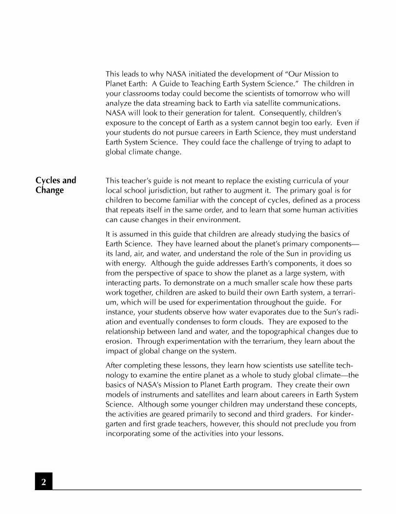
Naturally occurring volcanic eruptions and large forest fires can impact theEarth’s system just like human-caused air pollution. These events can fillthe atmosphere with dust and darken the global “greenhouse roof,” whichresults in cooling. This is why scientists must study Earth as a system tounderstand how the planet is changing beyond these natural events.
Terrarium: Part 6, Global Cooling.
Cover the terrarium with smoked or dirty glass or colored plastic wrap.Place it in the sunlight and take the temperature inside the terrarium after anhour. In the same way that volcanic dust or air pollution has a coolingeffect on the atmosphere, the temperature will not increase as much as itdid when the clear glass was used to cover the terrarium (TerrariumObservation, Part 5).
Global Cooling.
Examine photos that show urban pollution, volcanic explosions, Amazonbasin fires, and wildland fires in the Los Angeles area. These are sources ofair pollution that have a cooling effect on Earth’s atmosphere. Show photosof the human activities that cause air pollution and fires. Discuss how peo-ple could change their behavior and technology to prevent air pollution.
21
Observation
GlobalCooling

22

The Mission to Planet Earth is NASA’s program to determine scientificallywhether Earth’s climate is changing and to assess the contribution of humanactivities. Scientists are using satellite-borne instruments to measure theinteractions of the atmosphere, oceans, and solid Earth through hydrologicand biogeochemical cycles. Scientists need data from many sources to geta better picture of the whole system. You could compare the Mission toPlanet Earth program to other NASA programs where the agency has devel-oped sophisticated instruments and satellites to study the environments ofother planets in our Solar System.
Satellites are particularly effective because they can cover the entire globeevery few days. They can see a whole ocean at once to study wind, tem-peratures, and currents. Scientists use advanced computers to analyze thedata from satellites and make predictions using mathematical “models.”Models could be said to work like a computer game, but in this case, thegame simulates the Earth system. With data about how Earth works as asystem, we can understand human impacts and cooperate as nations tomake sure the planet remains healthy and life-sustaining.
Scissors, cardboard, paper, string, paint or crayons, egg cartons, paper toweland toilet paper rolls, paper or foil cupcake holders, paper plates, aluminumfoil, poster paint.
Students will be able to:
• Identify satellite components: antennae, solar arrays, and instruments to study Earth from space.
• Associate color data images with NASA’s Mission to Planet Earth program.• Recognize that Earth’s climate can be studied by a variety of professionals.
23
MISSI N TO PLANET EARTHSatellites: Observing the Whole Earth
Introduction
Objectives
Materials
Unit 4

• NASA Lithograph: TOPEX/Poseidon
• NASA Lithograph: First Image of Global Biosphere
• NASA Lithograph: Viking Orbiter 1 Mars Mosaic
• NASA Lithograph: Sea Surface Temperature
• NASA Lithograph: World Cloud Cover Pattern
• NASA Lithograph: Water is a Force of Change
• NASA Lithograph: Viking Orbiter 1 Mars Mosaic
Computer Model
Data Satellite
24
Visuals
Vocabulary

25
HIG
H P
OW
ER
AN
TEN
NA
LOW
PO
WER
AN
TEN
NA
SATE
LLIT
E
CO
NTR
OLS
THRU
STERS
PO
WER S
YST
EM
INST
RU
MEN
TIN
STRU
MEN
TH
OU
SIN
G
NA
VIG
ATO
R
AN
TEN
NA
SOLA
R A
RRA
Y
INST
RU
MEN
T
INST
RU
MEN
T
INST
RU
MEN
T
Sate
llite
Par
ts
TOPE
X/P
osei
don
Earth-observing satellites observe our planet from paths called orbits, manyof which are greater than 400 miles above the ground. That distance is atleast as far as Washington, D.C. to Boston, Massachusetts. Satellites are sohigh above Earth and travel so quickly that, in the right orbit, a satellite canpass over every part of Earth once every few days. Such orbits allow satellitesto study and take pictures of all of Earth’s features: land, plant life, oceans,clouds, and polar ice. Some satellites, such as those used for weather fore-casting, are placed in fixed orbits to look at Earth continuously.
Satellite instruments are like special cameras that see and take pictures indifferent kinds of light, such as in ultraviolet (invisible energy from the Sunthat causes sunburns) and infrared (heat waves). From satellite data, we cansee farmers’ fields and tell whether crops are healthy. This tells us about thefood supply. We can see the forests and tell where something is killingtrees. This tells foresters that they may need to look for blight or gypsy-moth infestations. We can see forest fires and tell how fast the forests arebeing cut down. Satellites also see clouds, hurricanes, lightning, and rain.In addition, we can see the temperatures and movements of ocean currents.And from the color of the oceans, we can see the abundance of tiny plants,called phytoplankton, which are an important food source for fish.
Engineers design satellites to support instruments flown in space. Satellitesmust be light enough to be carried into space on rockets, yet strong enoughto withstand the forces of launching. The materials used must handle hotand cold temperature extremes because most satellites will pass from theday to night side of Earth many times in 24 hours. Scientists use specialpaints on the instruments to control temperature. (In Unit One we learnedthat dark colors absorb solar heat and light colors reflect it.) Satellites’ solarcells extend like wings to capture solar energy and convert it into electricity.When the satellite is on the night side of Earth, it runs on batteries that arerecharged during the day from solar energy.
26
Satellites
SatelliteDesign
Instruments

Data come down as electronic signals from satellites, and engineers and sci-entists convert them into measurements useful to us on Earth. For studyingweather, scientists create maps of clouds. Meteorologists compare the satel-lite maps to their ground data and learn more about weather patterns.Scientists compare ocean-color data gathered by a satellite to measurementstaken by oceanographers on ships showing the abundance of phytoplank-ton. Microwave radar signals from space are compared to rainfall measure-ments on Earth. Computer engineers organize and store vast quantities ofsatellite data so that the information can be sent via computer networks toscientists around the globe.
In the same way students made a terrarium as a model of Earth, scientistsuse computers to create models to predict what will happen when globalchanges occur. Will the temperatures rise because of warming caused bygreenhouse gases? Can we see a warming trend even if a major volcanohas erupted? A model is like a “what-if” game. When you play “what-if”using a computer model, your prediction is based only on available dataand scientific principles.
Demonstrating Heat Sensors.
Show students how heat-sensing instruments work by letting them holdheat-sensitive cards (frequently given away at health fairs), “mood rings,” oraquarium thermometers. The warmer you are, the darker the color appearson the card or ring registering your body temperature. The data in the litho-graphs, “World Cloud Cover Pattern” and “Global Sea Surface Temperature,”were collected during observations from satellites carrying heat-sensing orinfrared instruments.
Satellite Construction.
1. Satellite Construction: Students can make their own satellites out of paper, cardboard, and recycled containers. Use foil or plastic wrap on acardboard frame for solar arrays; paper or foil plates could be antenna dishes; aluminum foil could be a heat-resistant metallic surface. Encourage the students to pretend that their satellites are going to observe components of the Earth system found in their terrariums or
27
Modeling
Data
Activities

aquariums. Let them use their imaginations to determine the satellite’s shape, instruments, and the equipment it will need according to what they are going to observe. When they are finished, hang the satellites from the ceiling with fishing line. The satellites could be “observing” the terrariums or aquariums or their region of the country. Show studentsthe lithograph, “TOPEX/Poseidon.” Note in the illustration its orbit and what it is observing. Point to the solar arrays, antennae, and instruments.
2. Satellite Launch and Deploy: Divide the class into launch teams; let them pick roles and dramatize a Space Shuttle or rocket launch and satellite deploy. Use real or invented language for their missions. Each child could bring in baseball cap. Attach the job label to the cap; later have them try different jobs by switching labels. Such jobs are Mission Commander, Payload Commander, Pilot, Mission Specialists, Project Scientists, Flight Director.
3. Data: Scientists study Earth by taking measurements of light that we cannot see. They assign artificial colors to represent each measurement.It’s as though you were coloring a picture, and you had to decide which crayon to use for each part of the picture. Each child should draw and color “data” collected by their satellites (see data map, page 29). Choosedifferent colors to represent each kind of measurement. For example, the healthiest plants could be compared to the progressively more dried-out plants. The healthy plants could be represented by reds, oranges and yellows. Try the same color scheme to compare conditions in the different terrariums. Look at the lithograph, “The First Image of the Global Biosphere.” These ocean data are indicated by red and orange for high concentrations of plant life in the oceans (phytoplankton), blue and violet for lower concentrations. On the land, forests are indicated byall shades of the color green. Semi-arid steppes and tundra are orange, and deserts and ice are yellow. A black and white map of Earth is included for classes that want to try coloring global Earth data.
28

29
54
32
1
Col
dC
ool
Mild
War
mH
ot
5
4
3
1
5
4
3
22
1
4
2
12
2
3
4
4
2
43
2
4
3
3 2
34
3
Our
Mis
sion
to
Plan
et E
arth
Surf
ace
Tem
pera
ture

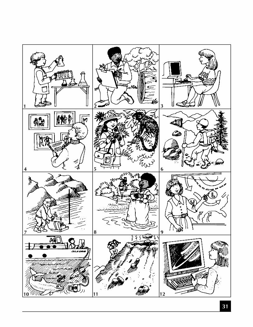
Mission to Planet Earth Careers.
Let students pick a career. Ask them to tell a story in the form of an auto-biography about how their Earth science career (“what I want to be when Igrow up”) could help improve knowledge of Earth or life on Earth.Improvise a costume and tools. Find or draw pictures of the Earth compo-nent they want to study, and ask the students to draw and color examples ofdata they will obtain.
1. Atmospheric Chemist: I study the atmosphere over time to understand what is natural and what has changed because of pollution. I take sam-ples from aircraft or balloons, conduct laboratory experiments, and cre-ate computer models.
2. Climatologist: I study weather on a big scale over a long period of time—even centuries. I gather samples that show long-term histories, like those taken from the bottom of the ocean or from polar ice cores. I also study the growth rings of trees, and then I predict the future climate.
3. Mathematician Computer Scientist: I invent and improve computers and programs to study data about Earth. I know how to create programson computers that are more complicated than computer games. I makethe work of many scientists possible by keeping all the satellite informa-tion easy to access and understand.
4. Sociologist: I study people in large populations—how they live, grow food, and manufacture things. From what I learn about large numbers of people, I can help predict what people could do to the environment. My work helps decision makers make policies that help prevent dam-ages to the environment.
5. Ecologist: I study various forms of life on Earth and how they interact. I go out in ships or use aircraft and satellites to measure where and how healthy the plants and animals are in their habitats. See the lithograph, “First Image of the Global Biosphere.” We can learn from observing the abundance of life what changes are occurring environmentally on Earth.
30
Activity
Careers
31
1 3
4 5 6
7 8 9
10 11 12
2

6. Geologist/Geophysicist: I study how Earth is formed, what has hap-pened to it since then, and what might happen to it in the future. I study volcanoes, earthquakes, and landslides. I can study rocks and rock formations and determine the geological history of an area.
7. Glaciologist: I study glaciers in the Arctic and Antarctic as well as those formed in the tallest mountains. I study temperatures, snow accu-mulation, and deep ice cores to understand what is happening to the glaciers. I also use satellites and aircraft to get these data (see lithograph;“Water is a Force of Change”).
8. Hydrologist: I study the water cycle. I study where the water goes, what elements it contains, and whether its chemistry has changed. My research often is used to determine where droughts occur and why fish populations decline.
9. Meteorologist: I study weather, the local short-term changes that affect how we live every day. I use satellites and ground measurements to predict the weather. You can see some meteorologists on television news. See the lithographs, “World Cloud Cover Pattern” and “Water isa Force of Change” (hurricane photograph).
10. Oceanographer: I study oceans and how they change. I work on ships or in aircraft and get data from floats and satellites. See the lithograph,“Global Sea Surface Temperature.”
11. Volcanologist: Using ground instruments, I study volcanoes and how they influence the climate. I use satellite and robots to gather data when the volcanoes are active and become too dangerous to go near.
12. Planetologist: I study planets other than Earth. When I compare planets like Mars, which has very little water compared to Earth, I can learn moreabout what could happen to our planet. The only way I can study Mars is by observing the planet with large telescopes or using data collected by satellites, such as that obtained by Voyager. Compare the lithograph of Earth from space with the litho, “Viking Orbiter 1 Mars Mosaic.”
32

NASA’s Central Operation of Resources for Educators (CORE) was established for thenational and international distribution of NASA-produced educational materials in audiovisualformat. Educators can obtain a catalogue and an order form by one of the following methods:
• NASA CORELorain County Joint Vocational School15181 Route 58 SouthOberlin, OH 44074
• Phone (440) 774-1051, Ext. 249 or 293
• Fax (440) 774-2144
• E-mail [email protected]
• Home Page: http://spacelink.nasa.gov/CORE
Educator Resource Center NetworkTo make additional information available to the education community, the NASA EducationDivision has created the NASA Educator Resource Center (ERC) network. ERCs contain a wealthof information for educators: publications, reference books, slide sets, audio cassettes, videotapes,telelecture programs, computer programs, lesson plans, and teacher guides with activities.Educators may preview, copy, or receive NASA materials at these sites. Because each NASA FieldCenter has its own areas of expertise, no two ERCs are exactly alike. Phone calls are welcome ifyou are unable to visit the ERC that serves your geographic area. A list of the centers and theregions they serve includes:
33
NASA Resources for Educators
AK, AZ, CA, HI, ID, MT, NV, OR, UT, WA, WYNASA Educator Resource CenterMail Stop 253-2NASA Ames Research CenterMoffett Field, CA 94035-1000Phone: (650) 604-3574
CT, DE, DC, ME, MD, MA, NH, NJ, NY, PA, RI, VTNASA Educator Resource LaboratoryMail Code 130.3NASA Goddard Space Flight CenterGreenbelt, MD 20771-0001Phone: (301) 286-8570

CO, KS, NE, NM, ND, OK, SD, TXJSC Educator Resource CenterSpace Center HoustonNASA Johnson Space Center1601 NASA Road OneHouston, TX 77058-3696Phone: (281) 483-8696
FL, GA, PR, VINASA Educator Resource LaboratoryMail Code ERLNASA Kennedy Space CenterKennedy Space Center, FL 32899-0001Phone: (407) 867-4090
KY, NC, SC, VA, WVVirginia Air and Space MuseumNASA Educator Resource Center forNASA Langley Research Center600 Settler’s Landing RoadHampton, VA 23669-4033Phone: (757) 727-0900 x 757
IL, IN, MI, MN, OH, WINASA Educator Resource CenterMail Stop 8-1NASA Lewis Research Center21000 Brookpark RoadCleveland, OH 44135-3191Phone: (216) 433-2017
AL, AR, IA, LA, MO,TNU.S. Space and Rocket CenterNASA Educator Resource Center for
NASA Marshall Space Flight CenterP.O. Box 070015Huntsville, AL 35807-7015Phone: (205) 544-5812
MSNASA Educator Resource CenterBuilding 1200NASA John C. Stennis Space CenterStennis Space Center, MS 39529-6000Phone: (228) 688-3338
NASA Educator Resource CenterJPL Educational OutreachMail Stop CS-530NASA Jet Propulsion Laboratory4800 Oak Grove DrivePasadena, CA 91109-8099Phone: (818) 354-6916
CA cities near the centerNASA Educator Resource Center forNASA Dryden Flight Research Center45108 N. 3rd Street EastLancaster, CA 93535Phone: (805) 948-7347
VA and MD’s Eastern ShoresNASA Educator Resource LabEducation ComplexVisitor Center Building J-1NASA Wallops Flight FacilityWallops Island, VA 23337-5099Phone: (757) 824-2297/2298
34
Regional Educator Resource Centers (RERCs) offer more educators access to NASA edu-cational materials. NASA has formed partnerships with universities, museums, and other educa-tional institutions to serve as RERCs in many states. A complete list of RERCs is available throughCORE, or electronically via NASA Spacelink at http://spacelink.nasa.gov

NASA On-line Resources for Educators provide current educational information andinstructional resource materials to teachers, faculty, and students. A wide range of information isavailable, including science, mathematics, engineering, and technology education lesson plans,historical information related to the aeronautics and space program, current status reports onNASA projects, news releases, information on NASA educational programs, useful software andgraphics files. Educators and students can also use NASA resources as learning tools to explore theInternet, accessing information about educational grants, interacting with other schools which arealready on-line, and participating in on-line interactive projects, communicating with NASA sci-entists, engineers, and other team members to experience the excitement of real NASA projects.
Access these resources through the NASA Education Home Page: http://www.hq.nasa.gov/education
NASA Television (NTV) is the Agency’s distribution system for live and taped programs. Itoffers the public a front-row seat for launches and missions, as well as informational and educa-tional programming, historical documentaries, and updates on the latest developments in aero-nautics and space science. NTV is transmitted on the GE-2 satellite, Transponder 9C at 85degrees West longitude, vertical polarization, with a frequency of 3880 megahertz, and audio of6.8 megahertz.
Apart from live mission coverage, regular NASA Television programming includes a Video File fromnoon to 1:00 pm, a NASA Gallery File from 1:00 to 2:00 pm, and an Education File from 2:00 to3:00 pm (all times Eastern). This sequence is repeated at 3:00 pm, 6:00 pm, and 9:00 pm, Mondaythrough Friday. The NTV Education File features programming for teachers and students on science,mathematics, and technology. NASA Television programming may be videotaped for later use.
For more information on NASA Television, contact: NASA HeadquartersCode P-2NASA TVWashington, DC 20546-0001 Phone: (202) 358-3572 NTV Home Page: http://www.hq.nasa.gov/ntv.html
How to Access NASA’s Education Materials and Services, EP-1996-11-345-HQThis brochure serves as a guide to accessing a variety of NASA materials and services for educa-tors. Copies are available through the ERC network, or electronically via NASA Spacelink. NASASpacelink can be accessed at the following address: http://spacelink.nasa.gov
35

Listed below are additional Mission to Planet Earth Materials available through the EducatorResource Center Network or NASA Spacelink.
Teacher • “Atlas 1 Earth’s Mysterious Atmosphere Teacher’s Guide” (EP-282 11/91)Guides • “La misteriosa atmosfera de la Tierra” (EP290 3/93)
• Atlas 2 Teacher’s Guide with Activities: Atmospheric Detectives (EP285 11/92)
Lithographs • “Earth View” HQL-331• “Nimbus-7 TOMS Images: The 8 Marches” HQL -366• “Nimbus-7 TOMS Images: The 12 Octobers” HQL-308• “Nimbus-7 Ocean Ice Maps” HQL-319• “NASA and World Food Production” HQL-305• “The Upper Atmosphere Research Satellite” HQL-207
Brochure • “NASA’ s Mission to Planet Earth”
The following Mission to Planet Earth materials are available by writing Goddard Space FlightCenter, Educator Resource Center, Code 130, Greenbelt, MD 20771
Fact Sheets • “EOS: Understanding Earth on a Global Scale”
Mission to Planet Earth series:• “Ozone: What is it and why do we care about it?”• “Clouds and the Energy Cycle”• “El Niño”• “Global Warming”• “Volcanoes”• “Biosphere”• “Polar Ice”
NASA Facts are documents that provide general information and background on NASA-relatedmissions, research topics and activities.
36
The following videos, slide sets, and videodisc are available through CORE:
Videos • “Liftoff to Learning: The Atmosphere Below”• “TOPEX/Poseidon: A Mission to Planet Earth” (9 minutes)• “Mission to Planet Earth” Satellite Video Conference
April 14, 1993 ($24.00 plus $3.50 shipping)
Slide Sets “Atlas 1: Studying Mysteries in the Earth’s Atmosphere”“Volcanoes of Hawaii and the Planets”
Space Shuttle Earth Observing Photography Videodisc contains approximately 91,500 stillimages of the Earth taken during Space Shuttle missions from 1981-1991. The videodisc packageincludes the videodisc, a guide to the images, and two IBM-formatted disks containing an imagedescription database. The price for the package is $55 and is available from NASA CORE.
37

EP-1997-12-292-HQ
Office of Mission to Planet EarthOffice of Human Resources and Education

Lithographs for Use with this Packet
• Apollo 17 View of Earth
• Water is a Force of Change
• Global Sea Surface Temperature
• First Image of the Global Biosphere
• World Cloud Cover Pattern
• Topex/Poseidon
• Viking Orbiter 1 Mars Mosaic
NASALithographs

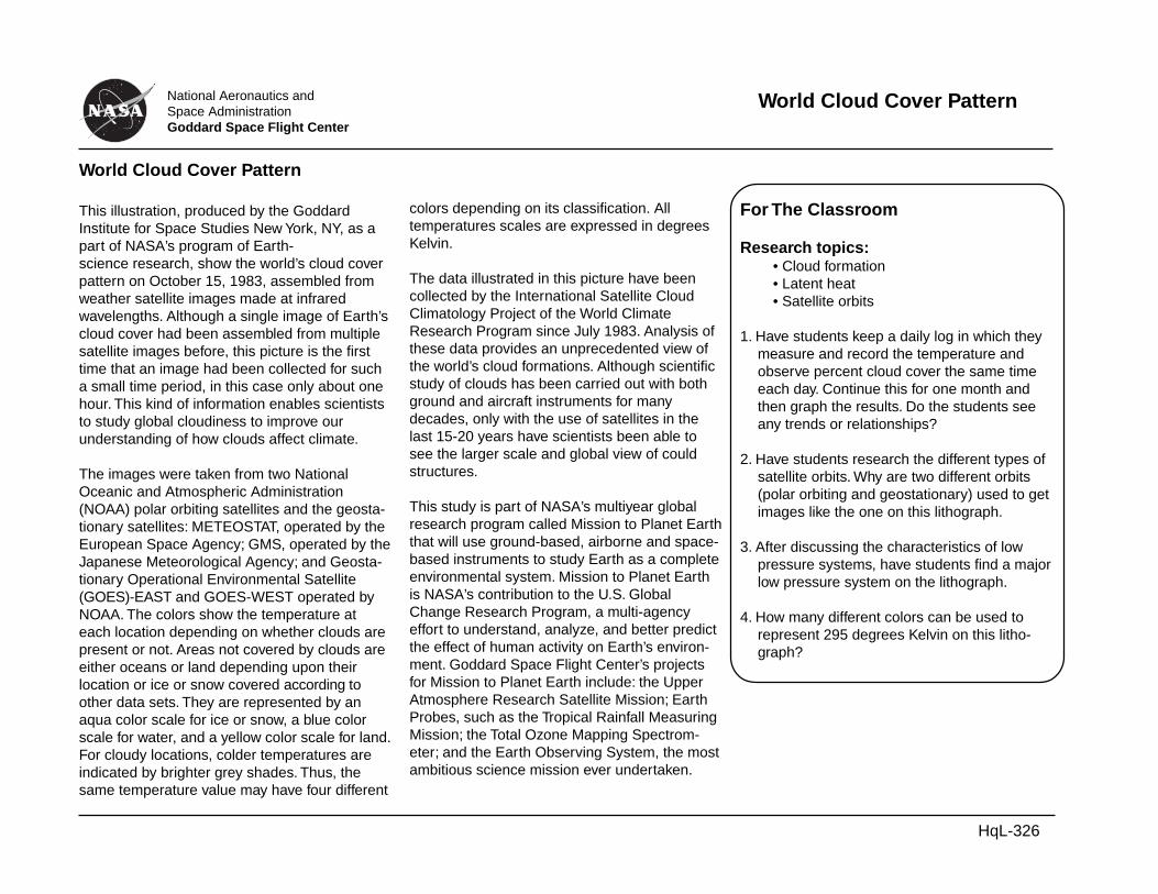
World Cloud Cover Pattern
This illustration, produced by the GoddardInstitute for Space Studies New York, NY, as apart of NASA’s program of Earth-science research, show the world’s cloud coverpattern on October 15, 1983, assembled fromweather satellite images made at infraredwavelengths. Although a single image of Earth’scloud cover had been assembled from multiplesatellite images before, this picture is the firsttime that an image had been collected for sucha small time period, in this case only about onehour. This kind of information enables scientiststo study global cloudiness to improve ourunderstanding of how clouds affect climate.
The images were taken from two NationalOceanic and Atmospheric Administration(NOAA) polar orbiting satellites and the geosta-tionary satellites: METEOSTAT, operated by theEuropean Space Agency; GMS, operated by theJapanese Meteorological Agency; and Geosta-tionary Operational Environmental Satellite(GOES)-EAST and GOES-WEST operated byNOAA. The colors show the temperature ateach location depending on whether clouds arepresent or not. Areas not covered by clouds areeither oceans or land depending upon theirlocation or ice or snow covered according toother data sets. They are represented by anaqua color scale for ice or snow, a blue colorscale for water, and a yellow color scale for land.For cloudy locations, colder temperatures areindicated by brighter grey shades. Thus, thesame temperature value may have four different
colors depending on its classification. Alltemperatures scales are expressed in degreesKelvin.
The data illustrated in this picture have beencollected by the International Satellite CloudClimatology Project of the World ClimateResearch Program since July 1983. Analysis ofthese data provides an unprecedented view ofthe world’s cloud formations. Although scientificstudy of clouds has been carried out with bothground and aircraft instruments for manydecades, only with the use of satellites in thelast 15-20 years have scientists been able tosee the larger scale and global view of couldstructures.
This study is part of NASA’s multiyear globalresearch program called Mission to Planet Earththat will use ground-based, airborne and space-based instruments to study Earth as a completeenvironmental system. Mission to Planet Earthis NASA’s contribution to the U.S. GlobalChange Research Program, a multi-agencyeffort to understand, analyze, and better predictthe effect of human activity on Earth’s environ-ment. Goddard Space Flight Center’s projectsfor Mission to Planet Earth include: the UpperAtmosphere Research Satellite Mission; EarthProbes, such as the Tropical Rainfall MeasuringMission; the Total Ozone Mapping Spectrom-eter; and the Earth Observing System, the mostambitious science mission ever undertaken.
For The Classroom
Research topics:• Cloud formation• Latent heat• Satellite orbits
1. Have students keep a daily log in which theymeasure and record the temperature andobserve percent cloud cover the same timeeach day. Continue this for one month andthen graph the results. Do the students seeany trends or relationships?
2. Have students research the different types ofsatellite orbits. Why are two different orbits(polar orbiting and geostationary) used to getimages like the one on this lithograph.
3. After discussing the characteristics of lowpressure systems, have students find a majorlow pressure system on the lithograph.
4. How many different colors can be used torepresent 295 degrees Kelvin on this litho-graph?
World Cloud Cover PatternNational Aeronautics andSpace AdministrationGoddard Space Flight Center
HqL-326

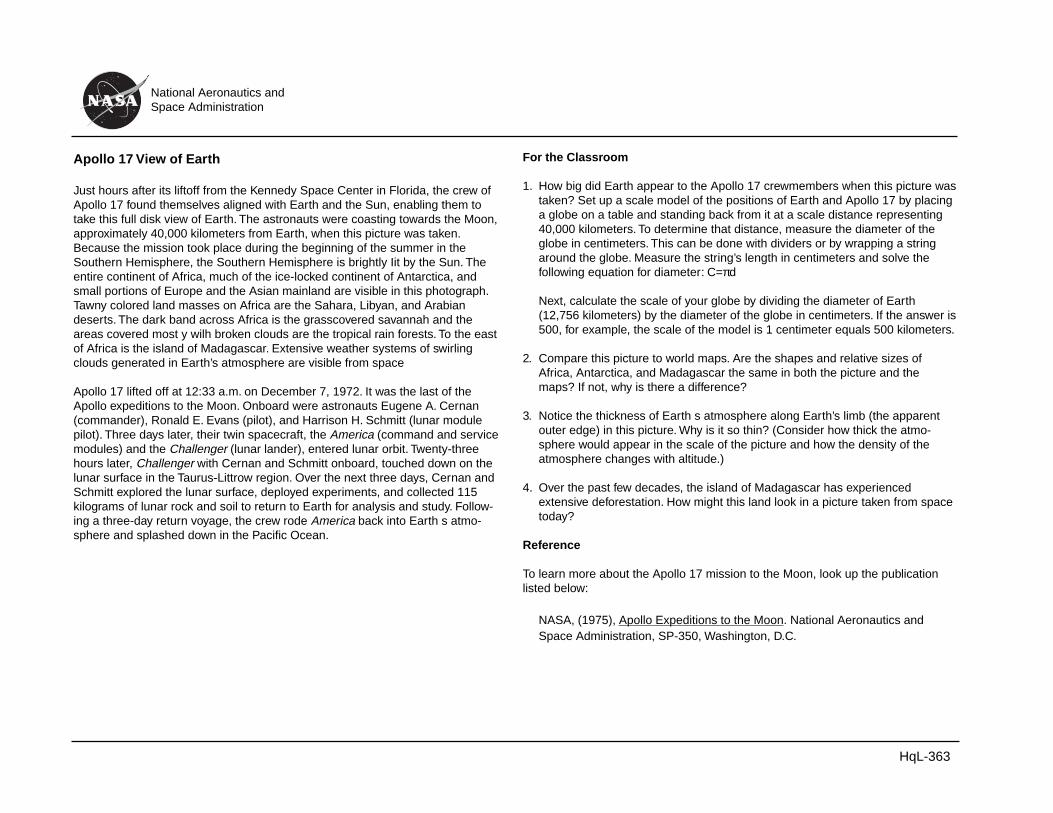
Apollo 17 View of Earth
Just hours after its liftoff from the Kennedy Space Center in Florida, the crew ofApollo 17 found themselves aligned with Earth and the Sun, enabling them totake this full disk view of Earth. The astronauts were coasting towards the Moon,approximately 40,000 kilometers from Earth, when this picture was taken.Because the mission took place during the beginning of the summer in theSouthern Hemisphere, the Southern Hemisphere is brightly Iit by the Sun. Theentire continent of Africa, much of the ice-locked continent of Antarctica, andsmall portions of Europe and the Asian mainland are visible in this photograph.Tawny colored land masses on Africa are the Sahara, Libyan, and Arabiandeserts. The dark band across Africa is the grasscovered savannah and theareas covered most y wilh broken clouds are the tropical rain forests. To the eastof Africa is the island of Madagascar. Extensive weather systems of swirlingclouds generated in Earth’s atmosphere are visible from space
Apollo 17 lifted off at 12:33 a.m. on December 7, 1972. It was the last of theApollo expeditions to the Moon. Onboard were astronauts Eugene A. Cernan(commander), Ronald E. Evans (pilot), and Harrison H. Schmitt (lunar modulepilot). Three days later, their twin spacecraft, the America (command and servicemodules) and the Challenger (lunar lander), entered lunar orbit. Twenty-threehours later, Challenger with Cernan and Schmitt onboard, touched down on thelunar surface in the Taurus-Littrow region. Over the next three days, Cernan andSchmitt explored the lunar surface, deployed experiments, and collected 115kilograms of lunar rock and soil to return to Earth for analysis and study. Follow-ing a three-day return voyage, the crew rode America back into Earth s atmo-sphere and splashed down in the Pacific Ocean.
For the Classroom
1. How big did Earth appear to the Apollo 17 crewmembers when this picture wastaken? Set up a scale model of the positions of Earth and Apollo 17 by placinga globe on a table and standing back from it at a scale distance representing40,000 kilometers. To determine that distance, measure the diameter of theglobe in centimeters. This can be done with dividers or by wrapping a stringaround the globe. Measure the string’s length in centimeters and solve thefollowing equation for diameter: C=πd
Next, calculate the scale of your globe by dividing the diameter of Earth(12,756 kilometers) by the diameter of the globe in centimeters. If the answer is500, for example, the scale of the model is 1 centimeter equals 500 kilometers.
2. Compare this picture to world maps. Are the shapes and relative sizes ofAfrica, Antarctica, and Madagascar the same in both the picture and themaps? If not, why is there a difference?
3. Notice the thickness of Earth s atmosphere along Earth’s limb (the apparentouter edge) in this picture. Why is it so thin? (Consider how thick the atmo-sphere would appear in the scale of the picture and how the density of theatmosphere changes with altitude.)
4. Over the past few decades, the island of Madagascar has experiencedextensive deforestation. How might this land look in a picture taken from spacetoday?
Reference
To learn more about the Apollo 17 mission to the Moon, look up the publicationlisted below:
NASA, (1975), Apollo Expeditions to the Moon. National Aeronautics andSpace Administration, SP-350, Washington, D.C.
National Aeronautics andSpace Administration
HqL-363


As we look at Earth from the vantage point ot outer space, we can’t but help notice how important water is to Earth’s surface. Three quarters of ourplanet is covered with liquid and frozen water. The land surface is shaped by water’s movements. Living things need water for survival. Water exists asvapor in the atmosphere and is the stuff of clouds. As a renewable resource, water transforms through three states of matter— solid, liquid, and—gasas it cycles from the oceans to the atmosphere, to the land, and back to the oceans. Water and its effects are the dominant features Space Shuttleastronauts see from space. Water is a powerful force of change.
National Aeronautics andSpace Administration
Upper left: Hurricane Bonnie, Atlantic Ocean (STS 47-151-618)Among the most destructive forces of nature, hurricanes andtyphoons are driven by the Sun’s heath and act as a great pressurerelief valve for Earth’s atmosphere. The view of Hurricane Bonnie wascaptured by the Crew of STS-47 as the storm swirled about 800kilometers away from Bermuda near 35.4 degrees north latitude and56.8 degrees west. At this stage in its life, Hurricane Bonnie has well-developed eye where air currents are relatively calm. Window reflec-tions are visible on the right side of the picture.
Lower left: Glaciers in the Andes Mountains (STS 48-151-074)Although much slower as an agent of change than is nunning water,mountain glaciers dramatically alter the land as the ice in themslowIy flows to lower elevations. Wrenching rock and soil from valleyfloors and walls, glaciers sculpt the land as they deposit sediment attheir lower end. In this STS-48 picture, some of the most dramaticlandscape in the Americas is seen. The Andes mountain range nearPatagonia, Argentina is partly covered by a permanent ice cap thatis part of the Los Glacieres National Park. One glacier is seencutting off an arm of Lake Argentina (top). Water backs up behindthe glacier and eventually gives way in spring in a thunderous burstthat can be heard as far as 40 kilometers away.
Upper right: Nile River Delta/Sinai Desert (STS 50-153-020)The presence and the absence of water are both clearly seen in thisSTS-50 view of the Sinai Peninsula from the Nile river into Iraq. TheFayum Depression, the well-watered valley of the lower Nile, and thefertile Nile Delta are dark in contrast to the lighter orange and yellow ofthe surrounding desert. The boundary between the light desert and darkerbrush land marks the Egypt-lsrael border. Other color variations arecaused by differences in bedrock composition and weathering.
Lower right: Mouth of the Amazon River (STS 46-80-009)Though slow-moving at its mouth, the Amazon River has deposited millionsof cubic meters of sediment into the Atlantic Ocean. Up river, heavy tropicalrains cover the Amazon Basin and wash away thin tropical topsoil to thesea. Converting rain forest to agricultural land aggravates the erosion. Thesediment plume from the river extends past the delta, built up of depositedsediment, and bends to the north to hug the coast. The plume is drivennorthward by the west by northwest Guyana Current. The large island ofMarajo is partly visible through the widespread scattered cloud cover. Thestnucture to the side of the picture is the remote manipulator system arm ofthe Shuttle orbiter.
Space Shuttle Earth PhotographyA videodisc containing over 91,000 images of Earth taken by Space Shuttle astronauts is available for a modest charge from NASA CORE, LorainCounty Joint Vocational School, 15181 Route 58 South, Oberlin, OH 44074. The images on the disk contain all Earth-looking still images takenduring the STS-1 through STS-44 missions. A computer data base listing image data is available for both DOS and Macintosh formats.
Water is a Force of Change
HqL-401June 1994


This illustration of Earth’s sea surfacetemperature is part of NASA GoddardSpace Flight Center’s program of Earth-science research. It was obtained from twoweeks of infrared observations by theAdvanced Very High Resolution Radiometer(AVHRR), an instrument on board NOAA-7during July, 1984.
Temperatures are color coded with redbeing warmest and decreasing throughoranges, yellows, greens, and blues.
Temperature patterns seen in this imageare the result of many influences includingthe circulation in the ocean, surface winds,and solar heating. Major ocean currentssuch as the Gulf Stream off the UnitedStates East Coast, the Kuroshio off theEast Coast of Japan, the mixing of theBrazil and Falkland currents off the easterncoast of South America, and the Agulhasoff southern Africa, appear as meanderingboundaries of cool and warm waters.
The image indicates a large pool of water inthe Western Pacific and a tongue of rela-tively cold water extending along the Equa-tor westward from South America. Everyfew years, there occurs an interrelated setof changes in the global atmospheric andoceanic circulation known as an El Niño in
National Aeronautics andSpace AdministrationGoddard Space Flight Center
which the region of warm equatorial waterin the west extends eastward across thePacific and blankets the cool, productiveregions along the coast of South America.Fish, birds, and marine mammals thatdepend upon the normally phytoplankton-rich waters often die in large numbersduring El Niño.
Images of sea surface temperature such asthis help scientists to better monitor andultimately understand the changes to Earthcaused by events such as El Niño.
This study is part of NASA’s multiyearglobal research program called Mission toPlanet Earth. It will use ground-based,airborne and space-based instruments tostudy Earth as a complete environmentalsystem. Mission to Planet Earth is NASA’scontribution to the U.S. Global ChangeResearch Program, a multi-agency effort tounderstand, analyze, and predict better theeffect on human activity on Earth’s environ-ment. Goddard Space Flight Center’sprojects for Mission to Planet Earth include:the Upper Atmosphere Research SatelliteMission; Earth Probes, such as the TropicalRainfall Measuring Mission; the Total OzoneMapping Spectrometer; and the mostambitious science mission ever undertaken,the Earth Observing System.
For the ClassroomResearch Topics:• El Niño• Upwelling• Major ocean currents• Mission to Planet Earth
1. Have students, individually or in teams,consult the Reader’s Guide to PeriodicalLiterature and compile a bibliography ofarticles dealing with different facets ofMission to Planet Earth (ocean tempera-tures, international cooperation, etc.).
2. John Muir, an American Naturalist, oncesaid “When we try to pick out anything byitself, we find it hitched to everything elsein the universe.”
Using this statement as a writing prompt,have students explain its meaning andhow it can be applied to the goal ofMission to Planet Earth.
3. Using this lithograph and a labeledworld map, have the students list coun-tries influenced by cool currents and listways in which these countries might beaffected by these currents.
Global Sea Surface Temperature
Global Sea Surface Temperature
HqL-324


This illustration of the global biosphere is part ofNASA Goddard Space Flight Center’s program ofEarth-science research. It shows, for the first time,the patterns of plant life both on the land and in theoceans as observed from space. The illustration wasproduced by combining data from two differentsatellites and shows Earth as a complex system,teeming with life.
Ocean Measurements
The ocean portion is a composite of more than66,000 images collected between November 1978and June 1986 by the Coastal Zone Color Scanner(CZCS), which flew on the Goddard-managedNIMBUS-7 satellite launched in October 1978. Theocean color measurements made by the CZCSindicate the distribution and abundance of phy-toplankton in Earth’s oceans. Phytoplankton aremicroscopic plants that grow in the upper sunlightregions of the ocean and are the ultimate food sourcefor most marine life. Their uptake of carbon dioxideduring photosynthesis is also be a key factor inhelping us to better understand the role of the oceansin the global carbon cycle.
Red and orange colors indicate areas of highconcentrations. Yellow and green represent areas ofmoderate concentrations. Blue and violet colorsrepresent the lowest concentrations.
The high phytoplankton concentrations along coastsand other regions where wind and currents mix thecooler, nutrient-rich waters near the surface, are oftenrich with fish and wildlife.
Land Measurements
The land vegetation image is a composite of threeyears of data, collected during 15,000 orbits from theAdvanced Very High Resolution Radiometer(AVHRR) flown on the NOAA-7 satellite, launched inJune 1981. The AVHRR measured land-surfaceradiation, which can be a measure of the potential forvegetation production on land.
The dark green areas (rain forests) show the highestpotential for vegetation growth. The lighter shades ofgreen highlight tropical and subtropical forests,temperate forests and farmlands, and some drierregions such as savannas and pampas. The yellowshades in the United States Midwest show lowerpotential. The great deserts of the world are evidentas the lighter shades of yellow. The snow and icecovered regions are shown to have no productivepotential in this image.
This study is part of NASA’s multiyear global re-search program called Mission to Planet Earth thatwill use ground-based, airborne and space-basedinstruments to study Earth as a complete environ-mental system. Mission to Planet Earth is NASA’scontribution to the U.S. Global Change ResearchProgram, a multiagency effort to understand, analyze,and better predict the effect of human activity onEarth’s environment. Goddard Space Flight Center’sprojects for Mission to Planet Earth include: theUpper Atmosphere Research Satellite Mission; EarthProbes, such as the Tropical Rainfall MeasuringMission; the Total Ozone Mapping Spectrometer; andthe Earth Observing System, the most ambitiousscience mission ever undertaken.
For the ClassroomResearch topics:
• Remote sensing• Phytoplankton and their requirements• Global carbon cycles• El Niño• Meteorological satellites
1. Rapid increases in phytoplankton biomass areknown as “blooms.” In the tropics, “blooms,” arestimulated by upwelling of cool, nutrient-richsubsurface waters. “Blooms” in temperate andpolar seas are caused by a different mechanism.What factor stimulates these seasonal blooms intemperate and polar seas? Remember thatphytoplankton are plants and have certainrequirements.
Answer: Amount of sunlight
2. According to the image on this lithograph, whichcontinent has the largest percentage of tropical/temperate forests? Why is this area one of globalconcern? How will images such as this assistthose in the study of deforestation?
Answer: a. South America b. Problems related to deforestation, global warming, etc. c. One way the images will assist scientists is in speeding the gathering of data regarding rates and areas of deforestation.
3. Have students create their own images by mappingthe vegetation in the school area or a nearby park.Have them develop a color scale that demon-strates where vegetation is present and where it isnot. You could have them get more involved byhaving herbaceous plants represented by adifferent color than woody plants.
National Aeronautics andSpace AdministrationGoddard Space Flight Center
First Image of the Global Biosphere
First Image of the Global Biosphere
HqL-325


National Aeronautics andSpace Administration Viking Orbiter 1 Mars Mosaic
Viking Orbiter 1 Mars Mosaic
It has been more than 15 years since the Viking mission spacecraft first ap-proached Mars. There were four spacecraft that made the journey to the redplanet. The Viking 1 and 2 landers entered Mars’s thin atmosphere and, by usingparachutes and then breaking rockets, came to rest on the surface. Viking Orbiters1 and 2 remained in orbit. Although all Viking spacecraft are now silent, the datacollected by them is stiil providing scientists with new insights about this solarsystem neighbor.
Using the Planetary Image Cartography System (PICS) developed at theU.S. Geological Survey, Flagstaff, Arizona, Tammy Becker, Alfred S. McEwen, andLarry Soderblom recently processed 102 Viking Orbiter 1 images taken of Mars in1980 to form this dramatic mosaic of nearly a full hemisphere of the planet. PICS,a computer-based system, permitted each image to be aligned with the others ina manner like fitting together the pieces of a jigsaw puzzle. Image distortions wereadjusted by PICS to provide perfect border matches. To bring out detail, colorvariations of the dark materials were enhanced by a factor oi about two andbrightness variations of the images adjusted to provide consistency across thehemisphere. The view is comparable to what would be seen from a spacecraftorbiting 2,500 kilometers above the surface of the planet.
The center of the Mars mosaic shows the entire Valles Marineris, acanyon system that stretches over 3,000 kilometers in length and is up to 8kilometers deep. The Grand Canyon of Earth compares to just one of the tributarycanyons of this giant system. Layers of bright material in the eastern and centralregion of the canyon may be carbonate-rich sediments deposited in an ancientlake. Huge ancient river channels, such as Kasai Valles, stretch northward fromthe central and western regions of the canyon.
South of Valles Marineris is very ancient terrain covered by many impactcraters. North of the eastern end of the Valles Marineris is the Chryse Planitia. TheViking 1 spacecraft landed in the place indicated on the sketch map.
To the west of Valles Marineris lie three of Mars’s huge volcanoes. TheTharsis volcanoes, as they are known, appear as dark reddish spots. Eachvolcano is about 25 kilometers high, over 350 kilometers in diameter, and has acentral crater at its summit. The most famous member of the Tharsis volcanoes,Olympus Mons, is not visible in the mosaic. It lies approximately 1,100 kilometerswest of Ascraeus Mons.
For the Classroom1. Research the Latin roots of surface feature names on Mars such as
labyrinthus, mons, planitia, and valles.2. Learn about the life and accomplishments of Percival Lowell.3. To visualize the size of the Martian features found on this mosaic, draw an
outline of the United States on a separate piece of paper to the same scale asthe mosaic. Cut out the outline and place it on the mosaic for comparison.(The distance between the central craters of Ascraeus Mons and PavonisMons is approximately 700 km.)
ReferencesCarr, M. H., ed., (1984), Geology of the Terrestrial Planets, NASA SP-469,
NASA Scientific and Technical information Branch, Washington, DC.Greeley, R. & Batson, R. M., ed., (1991), Planetary Mapping, Cambridge
University Press, New York.NASA, (1978), The Martian Landscape, NASA SP-425, NASA Scientific and
Technical information Branch, Washington, DC.Spitzer, G. R., ed., (1980), Viking Orbiter Views of Mars, NASA SP-441,
NASA Scientific and Technical information Branch, Washington, DC.
Ascraeus Mons
Pavonis Mons
Arsia Mons
Valles Marineris
Kasai Valles
Chryse Planitia andthe Viking 1 Lander Site(Mutch Memorial Station)
NoctisLabryinthus


National Aeronautics andSpace Administration
TOPEX/Poseidon
TOPEX/Poseidon
The Ocean Topography Experiment (TOPEX)/Poseidon is a cooperative project betweenthe United States and France to develop andoperate an advanced satellite system dedi-cated to observing Earth’s oceans. Themission provides global sea level measure-ments with an unprecedented accuracy. Thedata from TOPEX/Poseidon is used to deter-mines global ocean circulation and to under-stand how the oceans interact with theatmosphere. This understanding improvesour ability to predict global climate.
For this joint mission, the National Aeronauticsand Space Administration (NASA) providedthe satellite bus and five instruments withtheir associated ground elements. NASA’sJet Propulsion Laboratory is responsible forproject management and operates andcontrols the satellite through NASA’s Track-ing and Data Relay Satellite System. TheCentre Nationale d’Etudes Spatiales (CNES)furnished two instruments with their associ-ated ground elements and dedicated alaunch on an Ariane rocket. Both CNES andNASA provided precision orbit determination,and processed and distributed data to scien-tists from more than nine nations.
In the summer of 1992, an Ariane rocketlaunched TOPEX/Poseidon into orbit fromthe European Space Agency’s Space Centerlocated in Kourou, French Guiana. From itsorbit 830 miles (1,336 kilometers) aboveEarth’s surface, TOPEX/Poseidon makes sealevel measurements along the same pathevery 10 days using the dual frequencyaltimeter developed by NASA and the CNESsingle frequency solid-state altimeter. Thisinformation relates changes in ocean currentswith atmospheric and climate patterns.
Measurements from NASA’s Microwave Radi-ometer provides estimates of the total watervapor content in the atmosphere, which is usedto correct errors in the altimeter measurements.These combined measurements allow scien-tists to chart the height of the seas acrossocean basins with an accuracy of 5 centimeters.
Three independent techniques determine thesatellite altitude to within 5 centimeters. NASA’sLaser Retroreflector Array is used with anetwork of 10 to 15 satellite laser rangingstations to provide tne baseline tracking datafor precision orbit determination and calibrationof the radar altimeter bias. The DORIS systemprovides an alternate set of tracking data usingmicrowave Doppler techniques. The system iscomposed of an onboard receiver and a net-work of 40 to 50 ground transmitting stations,providing all-weather global tracking of thesatellite. NASA’s Global Positioning SystemDemonstration Receiver demonstrated a newtechnique for precise, continuous tracking ofthe spacecraft.
TOPEX/Poseidon is vital part of a strategicresearch effort to explore ocean circulation andits interaction with the atmosphere. It was timedto coincide with and complement a number ofinternational oceanographic and meteorologicalprograms, including the World CirculationExperiment (WOCE) and the Tropical Oceanand Global Atmosphere (TOGA) Program, bothof which are sponsored by the World ClimateResearch Program (WCRP). TOPEX/Poseidonwill build the foundation for a continuing pro-gram of long-term observations of oceancirculation from space, and for an extensiveocean monitoring program in the next century.
HqL-322

Our Mission to Planet Earth—A Guide to Teaching Earth System Science
EDUCATOR REPLY CARDTo achieve America’s goals in Educational Excellence, it is NASA’s mission to developsupplementary instructional materials and curricula in science, mathematics, geogra-phy, and technology. NASA seeks to involve the educational community in thedevelopment and improvement of these materials. Your evaluation and suggestions arevital to continually improving NASA educational materials.
Otherwise, please return the reply card by mail. Thank you.
1. With what grades did you use the educator guide?Number of Teachers/Faculty:
K-4 5-8 9-12 Community College
College/University - Undergraduate Graduate
Number of Students:
K-4 5-8 9-12 Community College
College/University - Undergraduate Graduate
Number of Others:
Administrators/Staff Parents Professional Groups
General Public Civic Groups Other
2. What is your home 5- or 9-digit zip code? __ __ __ __ __ — __ __ __ __
3. This is a valuable educator guide?
❏ Strongly Agree ❏ Agree ❏ Neutral ❏ Disagree ❏ Strongly Disagree
4. I expect to apply what I learned in this educator guide.
❏ Strongly Agree ❏ Agree ❏ Neutral ❏ Disagree ❏ Strongly Disagree
5. What kind of recommendation would you make to someone who asks about this
educator guide?
❏ Excellent ❏ Good ❏ Average ❏ Poor ❏ Very Poor
6. How did you use this educator guide?
❏ Background Information ❏ Critical Thinking Tasks
❏ Demonstrate NASA Materials ❏ Demonstration
❏ Group Discussions ❏ Hands-On Activities
❏ Integration Into Existing Curricula ❏ Interdisciplinary Activity
❏ Lecture ❏ Science and Mathematics
❏ Team Activities Standards Integration
❏ Other: Please specify: _________________________________________
7. Where did you learn about this educator guide?
❏ NASA Educator Resource Center
❏ NASA Central Operation of Resources for Educators (CORE)
❏ Institution/School System
❏ Fellow Educator
❏ Workshop/Conference
❏ Other: Please specify: _________________________________________
8. What features of this educator guide did you find particularly
helpful?
____________________________________________________________
______________________________________________________________
9. How can we make this educator guide more effective for you?
______________________________________________________________
______________________________________________________________
10.Additional comments:
______________________________________________________________
______________________________________________________________
Today’s Date:
Please take a moment to respond to the statements and questions below.You can submit your response through the Internet or by mail. Send yourreply to the following Internet address:
http://ednet.gsfc.nasa.gov/edcats/teachers_guide
You will then be asked to enter your data at the appropriate prompt.
EG-1997-12-292-HQ

Please P
laceS
tamp H
ereP
ost Office
Will N
ot Deliver
Without P
roperP
ostage
NAT
ION
AL A
ER
ON
AU
TIC
S A
ND
SPA
CE
AD
MIN
IST
RAT
ION
ED
UC
ATIO
N D
IVIS
ION
MA
IL CO
DE
FE
WA
SH
ING
TON
DC
20546–0001
Fold along line and tape closed.
!20
54
60
00
12
!