a land information system for turkey
DESCRIPTION
ÂTRANSCRIPT
Journal of Arid Environments (2003) 54: 513-525
A land information system for Turkey – a key to the country's
sustainable development S.H. Hallett*����, D.M. Ozden†, C.A. Keay����, A. Koral†, S. Keskin† & R.I. Bradley���� � National Soil Resources Institute, Cranfield University at Silsoe, Silsoe, Bedford MK45 4DT, U.K. †General Directorate of Rural Services, Eskişehir Yolu 9. Km. 06530 Lodumlu, Ankara, Turkey
(Accepted 17 July 2002)
This paper describes the development by the General Directorate of Rural Services (GDRS) of a land information system for Turkey, namely the National Soil and Water Information System. It is of great significance for the modern state of Turkey as, prior to its establishment in 1999 under the Turkish Agricultural Research Project, there was no definitive, national technological information resource underpinning land and water resource management. The system will underpin the operational and research responsibilities of the Directorate in combating some of the pressing contemporary environmental concerns in Turkey, including wind and water erosion, waterlogging, sodicity and salination of the soil resource. The complex process of compiling the first national digital soil map will be among the initial tasks, as well as establishing a national infrastructure for distributing the information amongst GDRS managers and scientists. With the proposed accession of the Turkish Republic to the European Union, alignment of the National Soil and Water Information System with European standards and protocols will prove to be an important facet of its ongoing development.
Key Words: Turkey; soil and water information system; GDRS; land management; Turkish Agricultural Research Project, TARP
* Corresponding author. Fax +44 1525 863253. E-mail: [email protected]

Introduction
The General Directorate of Rural Services (GDRS, or in Turkish, Köy Hizmetleri Genel Müdürlüğü, KHGM), a government Ministry in the Republic of Turkey, has established the Turkish Soil and Water Resources National Information Centre (NIC). The NIC aims to provide a comprehensive data framework for the natural resource management responsibilities of the Directorate as a whole and will serve to underpin the European soils-related requirements (King et al., 1998), subsequent to the proposed accession of Turkey to the European Union. An initial case-study project and feasibility study by the NIC and the UK National Soil Resources Institute (NSRI) covering the Ankara region has been followed by a programme to capture and store the first fully digital soil map of Turkey. Other sources of relevant information from similar resource information agencies at national and international levels have also been considered for inclusion within the system. The NIC will serve the commitments of GDRS to the development of the Turkish rural economy through the integration of soil and irrigation services, the planning of rural roads, potable water and power supplies, as well as land settlement planning.
GDRS and the Turkish Rural Economy The GDRS of today is founded upon three previous government Directorates; TOPRAKSU (General Directorate of Soil and Irrigation Works), YSE (General Directorate of Rural Road, Potable Water and Electricity Affairs) and TOPRAK ISKAN (General Directorate for Land and Settlement). These areas, now managed by the unified GDRS, deliver rural and agricultural services and social infrastructure to 76,457 villages and settlements in Turkey. This infrastructure includes the provision of drinking water, rural road construction, settlement of rural communities and agricultural extension activities. GDRS is committed to ‘contribute to the cost-effective and sustainable agricultural use of the land and water resources of Turkey, by the conduct of focussed research activities of international quality’ (KHGM, 1999a). This remit calls for the establishment and maintenance of the balance between the demands of rural socio-economic development and the need to support and sustain a fragile arid and semi-arid environmental resource. In the coming decades, this resource will be under increasing pressure and there are significant challenges faced in advancing this plan. By example, increasingly technologically based food production practices and poor management has contributed to problems ranging from wind and water erosion (Ozden and Sonmez, 1998; Taysun et al., 1998), waterlogging, sodicity and salination of the soil resource (Cullu et al., 1998). GDRS operates within a legislative framework which enforces the importance of its environmental management responsibilities, relating specifically to: (1) stopping erosion in areas suitable for agriculture, preventing damage from flood
waters, preserving water in the soil and maintaining productivity, (2) rendering suitable for agriculture, lands in private or state tenure that are degraded
because of acidity, salinity or sodicity, (3) providing services for irrigated agriculture, including land-levelling, on-farm
irrigation and drainage,

(4) constructing irrigation supply headworks for schemes requiring less than 500 ls-1 (5) classifying soils, carrying out analyses and producing information in regard to
productivity, irrigation, drainage, land clearing, improvement, consolidation and use capability,
(6) undertaking research in relation to all of the above (KHGM, 1995).
Traditionally, the Turkish national economy has been heavily dependent upon agriculture. Almost half the population of Turkey live in rural areas and work in the agricultural sector. From a total land area of 77.8 million hectares, Turkey has some 27.7 million hectares under arable farming. Within this, some 4 million hectares has been developed for irrigated production. Out of the further total stock of 8.5 million hectares of land considered to be capable of economic agricultural development, Turkey plans to increase the irrigated land area by 1.62 million hectares by the year 2001, supported by the necessary investments in infrastructure (KHGM, 1995). As the Turkish economy has developed, so the ongoing importance of the role played by the rural agricultural sector has become more apparent. Turkey’s overall social and economic prosperity still heavily depends upon the interplay of population, agricultural production and rural environment. Consequently, rural areas are in need of significant investment to underpin the development of sustainable agricultural production, social infrastructure and education.
The rural development services provided by GDRS aim to raise the general standard of living, and the Directorate has the responsibility for establishing the infrastructure to achieve this. In Turkey, quality agricultural land is a valuable but limited resource. It has been estimated that 1.5 million hectares of the Turkish arable land resource suffers from production limitations due to the effects of salinity, with a further 2.8 million hectares suffering from waterlogging. The condition of much of the available arable land has deteriorated over recent decades due to water and wind erosion. Some 63% of the total erosion recorded is categorised as severe or very severe, with 20% having moderate and 14% slight or negligible erosion (KHGM, 1987). Great importance is attached to increasing and sustaining agricultural production and in promoting the importance of soil and water research in Turkey (KHGM, 1995). To achieve the greatest benefit from the agricultural market, GDRS continually reviews and expands the use of contemporary technological and scientific advances. The role offered by information technology is recognised as being of profound importance in the sustainable management of natural resources (M.Gűner Saygili, GDRS Director General, Pers. Comm.), and this tenet has underpinned the establishment of the NIC.
The remit of the National Information Centre Prior to the creation of the NIC, there was no single centralised point of contact in GDRS for key geographical and related information used in its operational and research activities. Geographical Information System (GIS) developments are not new to GDRS as prototype research-oriented land information systems have been established in the GDRS Soil and Fertiliser Research Institute (SFRI) and the research institutes of Eskişehir and Erzurum. However, in general, research and management planning information has been produced and stored principally in non-digital form; each Regional and Provincial office collecting and holding the information it required for day-to-day activities, with little co-

ordination. Historically, the result has been poor information management and much duplication of resources. Furthermore, paper-based maps produced indicating locations of entities such as rural road features and potable water supply equipment have not been kept fully updated, with no formal central mechanism to service this requirement. The NIC was established to provide a managed system and a central repository for the core information resource of GDRS. To achieve this, the Centre was tasked with providing the ability to collect, integrate and analyse digital data deriving from a variety of different sources from within and outside GDRS, in satisfying its operational and research requirements. The ultimate intention is to extend the information and any related applications of the NIC to all the national offices of GDRS, providing its managers with an effective and easy access to the centralised resource. In drawing together the data resources required, and being advised by the UK National Soil Resources Institute (NSRI), the NIC has embarked upon the construction of the first Turkish national soil map in digital form. This work will constitute the initial focus for the activities of the Centre.
Formed in Ankara in the late 1990s with initial sponsorship through the World Bank Turkish Agricultural Research Project (TARP) project (KHGM, 1995), the NIC was tasked with addressing the following core functions in developing the rural economy (after KHGM, 1999b): 1. To collect and organise both point and spatial data on Turkish natural resources and
environment; 2. To develop a computerised Information System to store, manipulate and maintain
such data; 3. To provide a centralised resource for GDRS staff, reducing duplication of effort; 4. To act as a repository for publications containing rural environmental information on
Turkey; 5. To increase awareness of other organisations collecting and disseminating rural
environmental data in Turkey; 6. To use Geographical Information System and Remote Sensing techniques in the
analysis and planning of natural resources, the adoption of which will greatly speed researchers, users and decision-makers in their work;
7. By using the national database, preparations can be made for solving problems related to the usage of natural resources and their management. New data can be provided, the differences can be monitored and brought up to date;
8. To facilitate and encourage the exchange of ideas among resource information agencies at national and international levels.
Establishing an enterprise such as the NIC, calls for the adoption of flexible data management structures. Although focussing upon soil and water resource management in GDRS, the system is also intended to incorporate data sources from a number of other Government Directorates. Furthermore, the data holdings of the NIC are to be made available to other Government Directorates. When this occurs every effort will be made for such interchanges to occur directly over the Internet, and to subscribe to emergent spatial interoperability standards such as those of the OpenGIS Consortium’s ‘Open Geospatial Datastore Interface (OGDI) (SAI, 1998; Rigaux et al., 2002). Whilst it

appears unlikely that a comprehensive government-wide information system will be established in Turkey in the immediate future, the approaches adopted by the NIC will facilitate co-operative practices with other Government initiatives using the same sources and types of information. There does exist the long-term intention to develop a Turkish National GIS office, and if this occurs the approaches of the NIC should prove directly transferable. In the UK the phrases ‘joined-up government’ and ‘joined-up geography’ have emerged to describe the phenomenon of co-operative inter-Departmental sharing of information and knowledge. For natural resource management, such data frameworks will include thematic sources including soils, geology, watercourses, topography and other natural features. Allied to this are other data frameworks including political and cadastral boundaries, geo-demographics and street mapping.
Within GDRS, it is planned that the NIC should serve all elements of the Directorate’s activities and responsibilities (Fig. 1). In addition to the operational responsibilities of GDRS, there are also strong research and development activities. Here the NIC will contribute particularly to the fields of agronomy and soil management and conservation.
Soil and WaterResourcesNational
InformationCentre
General Directorate of Rural Services
The Turkish NationalGeographic Information System
Headquarters
Regi
onal
Directorates
Computer Cen
tre
Research Institutes
Provincial Directorates
Figure 1. The components of GDRS to be serviced by the NIC Source: NIC Management Team As the Centre develops, there will clearly be many opportunities for the data holdings of the NIC to feed directly into the work undertaken by GDRS at its Ankara headquarters site, its 11 research facilities and in its outlying regional and provincial offices. Three obvious areas for application of the NIC within GDRS are as follows.
1. Planning and operational activities through the timely provision of quality information. Examples including catchment rehabilitation, soil conservation, irrigation and drainage and land consolidation;
2. Provision of data resources for the research programmes. Examples including soil erosion modelling in sensitive catchments;
3. The spatial representation of the inventory asset data resource required for investment management research. Examples being geo-locations of major inventory assets.
In basing such functions upon the underpinning information system foundation, the NIC will follow other established European soil and land information systems such as the LandIS system of the UK National Soil Resources Institute (Dufour et al., 1998; Hallett et al., 1996).
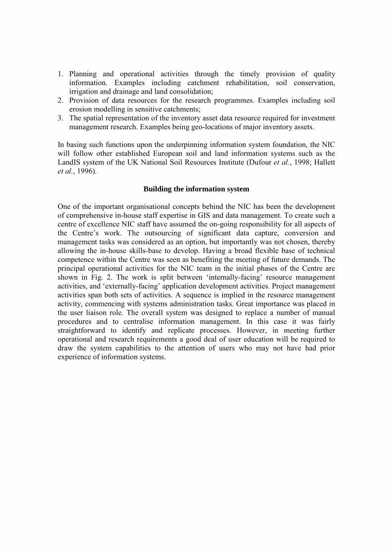
Building the information system One of the important organisational concepts behind the NIC has been the development of comprehensive in-house staff expertise in GIS and data management. To create such a centre of excellence NIC staff have assumed the on-going responsibility for all aspects of the Centre’s work. The outsourcing of significant data capture, conversion and management tasks was considered as an option, but importantly was not chosen, thereby allowing the in-house skills-base to develop. Having a broad flexible base of technical competence within the Centre was seen as benefiting the meeting of future demands. The principal operational activities for the NIC team in the initial phases of the Centre are shown in Fig. 2. The work is split between ‘internally-facing’ resource management activities, and ‘externally-facing’ application development activities. Project management activities span both sets of activities. A sequence is implied in the resource management activity, commencing with systems administration tasks. Great importance was placed in the user liaison role. The overall system was designed to replace a number of manual procedures and to centralise information management. In this case it was fairly straightforward to identify and replicate processes. However, in meeting further operational and research requirements a good deal of user education will be required to draw the system capabilities to the attention of users who may not have had prior experience of information systems.

Project Management
Application Development
User Liasion Teams
Help Desk Teams
Developer Solution Teams
Resource Management
InterfaceDevelopment
SystemsAdministration
DatabaseAdministration
SystemsAnalysis
DatabaseLoading
DataCapture
DataProcurement
QualityControl
Figure 2. Principal NIC activities and services Source: NIC Management Team Among the core information technologies to be implemented initially in the NIC will be Geographical Information Systems (GIS) together with database management systems (DBMS) and in due course Remote Sensing (RS). Together, these will permit the construction of toolkits aimed specifically at supporting decision-making or management relationship techniques, as well as providing information about a lot of different geographical structures, and analysis and usage of resources. Adopting such an approach will bring a number of advantages, providing a useful facility for users, offering effective means for data input, storage, analysis and presentation. The GIS will be used as a ‘data-mixer’ to create an integrated view of the variety of databases and data themes employed in the information system, spanning levels of map content, scale, detail and usage. The GIS will be further used to ‘spatialise’ existing data, and to provide access to the data resource through data mining and analysis techniques. The GIS will also play a role in presenting the information required to explain environmental policies and the impacts of decision making to an increasingly well-informed and participatory public. In this way, GIS offers a powerful tool for visualisation and presentation of the information resource.
A range of GIS software was evaluated for the purposes of the overall project; a factor in this was prior GIS software adoption elsewhere in GDRS. There were components within GDRS already possessing GIS expertise, notably the research institutes. The final choice of software was the ‘TNTmips’ package from the NPA Group (NPA, 2001), see Fig. 3. Although new software for GDRS, the choice was made for several reasons including; cost-performance, the level of local support offered, integration with existing Oracle-based database management systems, its ability to serve information via the Internet to Regional offices and importantly its strong support for the Turkish language in GIS interface design.
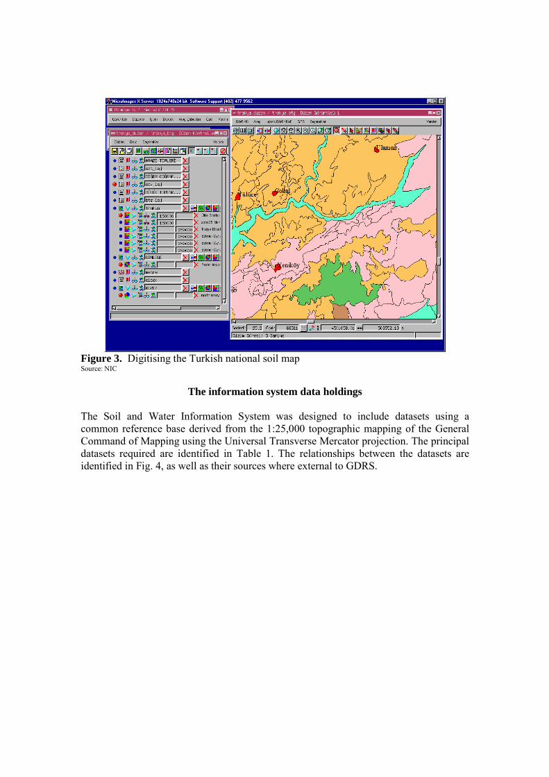
Figure 3. Digitising the Turkish national soil map Source: NIC
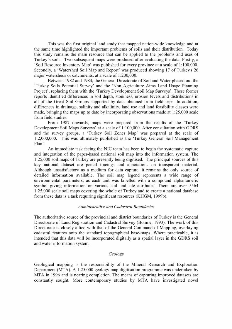
The information system data holdings The Soil and Water Information System was designed to include datasets using a common reference base derived from the 1:25,000 topographic mapping of the General Command of Mapping using the Universal Transverse Mercator projection. The principal datasets required are identified in Table 1. The relationships between the datasets are identified in Fig. 4, as well as their sources where external to GDRS.

Table 1. Principal datasets for the NIC Information System - the environmental data and associated spatial data types most sought after within GDRS operational and research
activities. Data Theme Category Description / Example Soil maps at the 1:25,000, 1:100,000 and 1:200,000 scales
Pedological group level classification
Administrative Boundaries / Locations Regional, Provincial, District, Village Geological maps at 1:25,000 scale Surface and sub-surface geology Climate and Meteorology Weather Station Records Topography Altitude, DEM/DTM Inventory Asset registry; wells, pumps, plants Cadastral data Land Ownership/parcels Hydrology River networks, catchment or watershed
drainage basins Remote sensing and aerial imagery Space imaging (NOAA, LANDSAT, SPOT,
IRS), Aerial photography
Land use, type and capability maps Current observed and classified Demography Census Records Cartographic – Raster 1:25,000 scale Raster basemaps for navigation Cartographic – Vector 1:25,000 scale Roads, Railways, Urban zones, etc. The following sections outline the main anticipated data holdings of the NIC information system. One notable absence is an up-to-date comprehensive thematic land-cover dataset. A basic land use map was prepared in parallel to the soil map described below, at a scale of 1:25,000 and was completed in 1970. However, there are now plans to derive a contemporary dataset using remotely sensed imagery, combined with a field validation for a pilot area in Trakya. If this pilot proves successful, the programme could be extended to cover the rest of the country.

Climate Data
Soil Maps
DigitisedAdministrativeboundaries
Hydrological Data
Cadastral Data
Topographic Data
Geology Data
Hydrological Data
Summary of Inventory Data
SOIL
AERIAL PHOTOGRAPHY
SATELLITE IMAGERY
HYDROLOGICAL
CADASTRAL
INVENTORY
TOPOGRAPHY
CLIMATE
GEOLOGY
ADMIN BOUNDARIES
Digitiseand LoadSoil Maps
Procure andLoad SmallScale HydroData
Procure andLoad LargeScale HydroData
Load Viewof InventoryData
Procureand LoadTopography
Procure, Loadand ProcessClimate Data
Procureand LoadGeology
Procure andLoad AdminBoundaries
Procure andLoadCadastral Data
GENERALCOMMAND
OF MAPPING
MINERALRESEARCH &
EXPLORATION
STATEHYDRAULIC
WORKS
GENERALDIRECTORATE OFRURAL SERVICES
EXTERNALPROVIDER
Key
Source
Dataset
Process
GDRS
NIC
Hydrological
Data Flow
Load view ofInventory data
Figure 4. Principle NIC data sources and inputs Source: NIC Management Team
The Turkish National Soil Map In Turkey the first real attempt at soil survey and mapping began in 1952 with the help of the United Nations Food and Agriculture Organisation (UN FAO). This resulted in the publication in 1954 of the 1:800,000 ‘Turkey General Soil Map’ and associated report, with geological and topographical maps being used to develop a reconnaissance-level study.
Subsequently, a Turkish soil classification was created. Between 1966 and 1971 the General Directorate of Soil and Water (now a part of GDRS) produced a series of soil maps including the ‘Turkey Development Soil Map (TDSM)’, using a 1:25,000 scale topographical basemap. However, the number of observations was more appropriate to a reconnaissance level map. In this survey, map units were described according to the 1938 American Soil Classification System based on soil groups and including soil and land features such as depth, slope, stoniness and erosion risk to delineate phases.
This was the first original land study that mapped nation-wide knowledge and at the same time highlighted the important problems of soils and their distribution. Today this study remains the main resource that can be applied to the problems and uses of Turkey’s soils. Two subsequent maps were produced after evaluating the data. Firstly, a ‘Soil Resource Inventory Map’ was published for every province at a scale of 1:100,000. Secondly, a ‘Watershed Soil Map and Report’ was produced showing 17 of Turkey's 26 major watersheds or catchments, at a scale of 1:200,000.
Between 1982 and 1984, the General Directorate of Soil and Water phased out the ‘Turkey Soils Potential Survey’ and the ‘Non Agriculture Aims Land Usage Planning Project’, replacing them with the ‘Turkey Development Soil Map Surveys’. These former reports identified differences in soil depth, stoniness, erosion levels and distributions in all of the Great Soil Groups supported by data obtained from field trips. In addition, differences in drainage, salinity and alkalinity, land use and land feasibility classes were made, bringing the maps up to date by incorporating observations made at 1:25,000 scale from field studies.
From 1987 onwards, maps were prepared from the results of the ‘Turkey Development Soil Maps Surveys’ at a scale of 1:100,000. After consultation with GDRS and the survey groups, a ‘Turkey Soil Zones Map’ was prepared at the scale of 1:2,000,000. This was ultimately published as the ‘Turkey General Soil Management Plan’.
An immediate task facing the NIC team has been to begin the systematic capture and integration of the paper-based national soil map into the information system. The 1:25,000 soil maps of Turkey are presently being digitised. The principal sources of this key national dataset are pencil tracings and annotations on transparent material. Although unsatisfactory as a medium for data capture, it remains the only source of detailed information available. The soil map legend represents a wide range of environmental parameters, as each unit was labelled with a compound alphanumeric symbol giving information on various soil and site attributes. There are over 5564 1:25,000 scale soil maps covering the whole of Turkey and to create a national database from these data is a task requiring significant resources (KHGM, 1999b).
Administrative and Cadastral Boundaries The authoritative source of the provincial and district boundaries of Turkey is the General Directorate of Land Registration and Cadastral Survey (Bohme, 1993). The work of this Directorate is closely allied with that of the General Command of Mapping, overlaying cadastral features onto the standard topographical base-maps. Where practicable, it is intended that this data will be incorporated digitally as a spatial layer in the GDRS soil and water information system.
Geology Geological mapping is the responsibility of the Mineral Research and Exploration Department (MTA). A 1:25,000 geology map digitisation programme was undertaken by MTA in 1996 and is nearing completion. The means of capturing improved datasets are constantly sought. More contemporary studies by MTA have investigated novel
techniques for identifying active faults in the rift valleys of western Turkey using digital terrain data (Akman et al., 2001).
Climate
Historic climate data is held in publications of meteorological station data produced by the State Meteorological Service (SMS). These documents contain daily, monthly and annual summaries for approximately 400 meteorological stations in Turkey. These data are not currently held in a digitised form and will need to be entered either by hand or using raster-scanning technology. SMS have, however, provided useful datasets for recent meteorological research in degree-day modelling (Büyükalaca et al., 2001), and such accumulated temperature data could be utilised as the basis for crop-suitability modelling applications (Hallett and Jones, 1993).
Topographical Base-Mapping Topographic datasets for Turkey are the responsibility of the General Command of Mapping (GCM), part of the Turkish Ministry of Defence. The General Command of Mapping has completed a series of 5,564 1:25,000 scale topographic maps for the whole of Turkey (Bohme, 1993). This basic scale mapping is prepared to conform to the Universal Transverse Mercator (UTM) grid with 6o bands, using the Hayford International 1909 Ellipsoid. Each of the map sheets displays an area of 7’ 30” latitude by 7’ 30’’ longitude and is prepared on a five-colour base with contour data being included at 10-metre contour intervals. The Unit has also completed a 72 map series at 1:250,000 scale. Each of the map sheets displays an area of 1o 30’ longitude by 1o latitude and includes contours at 100-metre intervals with supplementary at 50 and 25 metres. On these latter map sheets, relief is represented through hill-shading techniques and also contour data. The General Command of Mapping is also creating digital 10-metre contours from the 1:25,000 scaled maps; it has completed digital 100, 50 and 25 metre contours from the 1:250,000 scaled maps for the whole of Turkey. As the data become available, they will form a keystone for the NIC database resource. The General Command of Mapping also maintains an archive of aerial photographs. These photographs are mostly black and white and could, in most instances, be considered as the basis for other mapping purposes.
Inventory, Census and Small-Scale Hydrology GDRS is responsible for mapping and recording inventory, census and small-scale hydrological features (operating at <500 l/s). This information is captured and managed in a purpose-built Inventory information system. It is envisaged that it will be necessary for the NIC system to interact with the Inventory system, providing access to spatial referencing for its features (Table 3).
Table 3. Inventory, Census and Small-Scale Hydrology Data in the NIC System 1. Sub-districts 12. Irrigation dams
2. Villages 13. Water pipes 3. Sub-villages 14. Hydrogeological information 4. Resettlement 15. Wells 5. Bridges 16. Pumps 6. Agriculture 17. Co-operatives 7. Rural roads 18. Economic plants 8. Drinking water facilities 19. Ground and underground water wells 9. Land consolidation 20. Land development services 10. Electricity plants 21. Collector pipes 11. Income sources and settlement places
for migrating families 22. Soil conservation and new settlements
The Inventory also holds population data for the villages derived from the State Institute of Statistics (SIS), and having recently become operational, these data are now being loaded. This process was completed in 2000. The geographic distribution of the data will be derived from the village location points. District and provincial town centre locations will not be available from this source as they tend to cover larger areas and a single grid reference is considered to offer impracticable referencing.
Large-Scale Hydrology In Turkey, large-scale hydrological features (>500 l/s) are the responsibility of the State Hydraulic Works (SHW). This department publishes reports on the rain flow and lake levels on a sub-catchment basis for the 26 major catchments in Turkey. It is planned to store digitised maps of the catchment and sub-catchment boundaries as a GIS layer within the NIC information system to enable the display of rain flow and associated data. Each catchment and sub-catchment would be given a SHW number and name as an attribute. Similarly a lake GIS layer could be digitised and linked with the lake level data. These observations would be held within the database system. The catchment, sub-catchment and lake numbers would be used to link the spatial areas to the observation data.
Developments of the information system The initial deployment of the NIC has been undertaken jointly between the GDRS Research, Planning and Co-ordination Department and the GDRS Computer Centre. The intention from the outset was to establish an infrastructure that would propagate its data and services to the outlying ‘clients’ from a central service (Fig. 1). A number of mechanisms for delivering content were envisaged according to the requirements and the recipients. This would range from the distribution of complete datasets, to on-demand mapping and analysis based on secure wide area network, or Internet World Wide Web access.
The greatest challenge for GDRS in managing agricultural land resources will come from salinity, waterlogging and erosion. Any comprehensive and sustainable rural policy must accommodate measures designed to ameliorate or reduce these factors. Yet, as the pace of development and the demands on the rural economy increase, the balance is harder to maintain. Furthermore, the strain placed upon GDRS resources by the recent

earthquake disasters has made the process of allocating resources and identifying priorities even more difficult.
The Soil and Water National Information System offers GDRS an effective and cost-efficient management tool to meet its many and varied responsibilities. Although still in its early days, the NIC has already drawn together many of the key thematic datasets which underpin such decision-making, with considerable effort being made in identifying the most appropriate distribution mechanisms for the resulting information. The Centre has also commenced with great efficiency the compilation of the first national soil map in digital form. This will be of great importance in the direction of the rural economy, especially given Turkey’s proposed accession to the European Union and the subsequent compliance required for its environmental Directives. The European Commission has a strong requirement for Europe wide information on soils to assist in the formulation of policies addressing topics such as freshwater and groundwater management policies, improved agricultural production, environmental protection and countering the threats of soil erosion and agricultural pollution (Burrill, 1996).
There are plans underway to enhance and improve the basic soil mapping resource in Turkey. It is anticipated that a national programme of detailed surveys may soon be commenced to determine factors including soil type, land use, land capability and fertility levels with greater precision and accuracy than before. In recognition of the limitations of the current soil mapping, which lacks fully comprehensive geo-located profile observations to validate the map separates, GDRS is planning two specific projects. Firstly, a revised version of the 1:1,000,000 scale soil map will be compiled, which will retain the original soil lines but will re-allocate the map units according to the FAO/Soil Map of Europe classification with a soil interpreted report (KHGM, 1999c). This development would allow for a variety of interpretations to be made consistent with research elsewhere in Europe (Van Ranst et al., 1995). Secondly it is proposed that a new land cover and land use map be compiled using modern technology and including classified remotely sensed imagery. This reappraisal of the soil mapping will feed directly into the planning requirements for catchment rehabilitation, soil conservation, irrigation and drainage and land consolidation projects. Also, soil and water analyses are conducted to determine the factors most limiting to agricultural yield and productivity, with farmers being provided with technical recommendations as to the appropriate use of fertilisers and other agrochemicals, together with suitable crop rotation patterns. In these cases, it is imperative that the NIC data framework be in place to handle and manipulate these new datasets. However, at this time, the financial constraints under which the NIC will operate in the future are not yet fully defined. Indications are that the importance of the NIC is fully recognised at the highest levels within GDRS and means are being sought to provide appropriate ongoing financial support. Future assessments will be required to identify and review the impacts the information system has upon the management and research of the key environmental problems identified. These will feedback into ongoing developments for the information system, supporting its value as an effective tool for GDRS.
Summary
The infrastructure has now been established for the development of the GDRS Soil and Water NIC. This resource will be highly valuable to GDRS supporting its responsibility towards the effective and sustainable ongoing management of the Turkish rural economy. The NIC will provide a cost-effective national centre of excellence in land information systems design and implementation, and its work will underpin a large part of the operational aspects, as well as the research activities undertaken in GDRS. For Turkey to gain the fullest benefit from this investment, it is important that the work of the NIC be made available in digital form to associated government directorates and agencies, such as the Ministry of Agriculture, the South-Eastern Anatolia Project (GAP) project offices, the State Hydraulic Works and the State Meteorological Service.
The initial steps are now underway to create the full infrastructure required to administer the national Soil and Water Information System, as well as the data resources that it will hold. An important task for the NIC is to retain and develop staff experienced in the use of GIS and database management, maintaining the impetus of the project and its developments. Operationally, this is made particularly difficult given the IT skills-shortage in Turkey. There are many challenges to be faced in the next decades as GDRS and associated government agencies and directorates address environmental threats including wind and water erosion, waterlogging, sodicity and salination of the soil resource. However, the tools that the NIC will offer will be an invaluable aid in natural resource and rural management and, importantly, would contribute further to the national information infrastructure following Turkey’s proposed accession to the European Union.
References Akman, A.U., Sanga, T., Narui, E. & Oikawa, N. (2001) Development of a new
technique for geological investigation using DTM data: an example in western Turkey. Int. J. Remote Sensing, 22: 5, 851-859.
Bohme, R. (1993) National Mapping Organisations: Turkey. In: Inventory of World Topographic Mapping. Vol. 3: Eastern Europe. London: Elsevier, on behalf of ICA.
Burrill, A. (1996) The European Commission’s Soil Information Focal Point. In: Le Bas, C. & Jamagne, M. (Eds.), Soil Databases to Support Sustainable Development. EUR 16371 EN, pp. 109-113. Luxembourg: Office for Official Publications of the European Communities.
Büyükalaca, O., Hüsamettin, B. and Yilmaz, T. (2001) Analysis of variable-base heating and cooling degree-days for Turkey. Applied Energy, 69: 269-283.
Cullu, M.A, Almaca, A., Öztürkmen, A.R., Ağca, N., İnce, F. & Derici, M.R. (1998) The Salinity Changes of Harran Plain Soils. In: Yesilsoy, M.S. (Ed.), Proceedings International Symposium on Arid Region Soils, pp. 375-380. International Society of Soil Science, Turkey 21-24 September, 1998. ISBN 975-96629-0-6.
Dufour, M.J.D., Hallett, S.H., Jones, R.J.A. & Gibbons, J.W. (1998). Spatial Information Systems for Environmental Impact Assessment in the UK. In: Heineke, H.J., Eckelmann, W., Thomasson, A.J., Jones, R.J.A., Montanarella, L. & Buckley, B. (Eds.) Land Information Systems: Developments for planning the sustainable use of land resources, pp. 403-418. EUR 17729 EN, Luxembourg: Office for Official Publications of the European Communities.
Hallett, S.H., Jones, R.J.A. & Keay, C.A. (1996). Environmental Information Systems Developments for planning sustainable land use. Int. J. Geographical Information Systems, 10: 1, 47-64.
Hallett, S.H. and Jones, R.J.A. (1993). Compilation of an Accumulated Temperature Database for use in an Environmental Information System. Agricultural and Forest Meteorology, 63: 21-24.
King, D., Meyer-Roux, J., Thomasson, A.J. & Vossen, P. (1998). A Proposed European Soil Information Policy. In: Heineke, H.J., Eckelmann, W., Thomasson, A.J., Jones, R.J.A., Montanarella, L. & Buckley, B. (Eds.) Land Information Systems: Developments for planning the sustainable use of land resources, pp. 11-18. EUR 17729 EN. Luxembourg: Office for Official Publications of the European Communities.
Köy Hizmetleri Genel Müdürlüğü (KHGM) (1987). Türkiye Genel Toprak Amanajman Planlaması (Toprak Koruma Ana Planı), KHGM.
Köy Hizmetleri Genel Müdürlüğü (KHGM) (1995). Toprak ve Su Kaynaklari Araştırma Master Planı, Araştırma Planlama ve Koordinasyon Dairesi Başkanlığı, Yayın No: 87, Türkiye Tarımsal Araştırma Projesi 3472 – TU.
Köy Hizmetleri Genel Müdürlüğü (KHGM) (1999a). http://www.khgm.gov.tr/ Köy Hizmetleri Genel Müdürlüğü (KHGM) (1999b). Türkiye Toprak ve Su Kaynaklari
Veri Tabanının Oluşturulması Projesi, Toprak ve Su Kaynaklari Ulusal Bilgi Merkezi
Köy Hizmetleri Genel Müdürlüğü (KHGM), (1999c). Türkiye Genel Toprak Haritası ve Raporunun FAO-UNESCO ve Toprak Taksonomisine Göre Güncelleştirilmesi, Toprak ve Su Kaynaklari Ulusal Bilgi Merkezi
SAI (1998) A Strategic View of GIS Research and Technology Development for Europe. Munro, A. (Ed.), EUR 18126 EN, Luxembourg: Office for Official Publications of the European Communities. 46 pp.
NPA (2001) http://www.npagroup.co.uk/gisandit/mipsinfo.html Ozden, S. & Sonmez, K. (1998) Erodibility of some great soil groups in Eastern Anatolia.
In: Yesilsoy, M.S. (Ed.), Proceedings International Symposium on Arid Region Soils, pp. 148-153. International Society of Soil Science, Turkey 21-24 September, 1998. ISBN 975-96629-0-6.
Rigaux, P., Scholl, M & Voisard, A. (2002) Spatial Datasets with Applications to GIS. Academic press, London. 408 pp.
Taysun, A., Abalı, İ & Uysal, H. (1998) Wind Erosion Damage: Importance and Prevention. In: Yesilsoy, M.S. (Ed.), Proceedings International Symposium on Arid Region Soils, pp. 255-260. International Society of Soil Science, Turkey 21-24 September, 1998. ISBN 975-96629-0-6.
Van Ranst, E., Vanmechelen, L., Thomasson, A.J., Daroussin, J., Hollis, J.M., Jones, R.J.A., Jamagne, M. & King, D. (1995). Elaboration of an Extended Knowledge Database to Interpret the 1:1,000,000 EU Soil Map for Environmental Purposes. In: King, D., Jones, R.J.A. & Thomasson, A.J. (Eds.), European Land Information Systems for Agro-Environmental Monitoring, pp. 71-84. EUR 16232 EN, II.3. Luxembourg: Office for Official Publications of the European Communities.