a landscape logic for sustainable rural...
TRANSCRIPT

A Landscape Logic for Sustainable Rural Development ‐
The Case of Indonesia’s Green Prosperity Program
Part 1: LOWLAND
02 October 2013 GRS Presentation
contents
I. Landscape Logic among Other Donors and Researchers
II. What is a GP Development Landscape? III. Risks of Failure to Adopt a Landscape
Approach for GP IV. “What is the Project?”
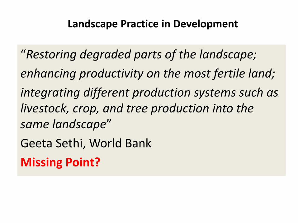
Landscape Practice in Development
“Restoring degraded parts of the landscape; enhancing productivity on the most fertile land; integrating different production systems such as livestock, crop, and tree production into the same landscape” Geeta Sethi, World Bank Missing Point?

Development Landscape Definition, Agricultural Context (source: FAO 2103)
o An area, as perceived by people, whose character is the result of the action and interaction of natural and/or human factors” (COE, 2000).
o Cultural landscapes have been defined by the World Heritage Committee as “distinct geographical areas or properties uniquely representing the combined work of nature and of man, illustrative of the evolution of human society and settlement over time, under the influence of the physical constraints and/or opportunities presented by their natural environment and of successive social, economic and cultural forces, both external and internal” (WHC 1996).
o Expanding on this, [development] landscapes may be defined as the concrete and characteristic products of the interaction between human societies and culture with the natural environment.

Development Landscape Definition, Agricultural Context (source: FAO 2103)
Agricultural landscapes … in terms of the three elements: STRUCTURE, which concerns the interaction between environmental features, land‐use patterns and human‐made objects;
FUNCTIONS, which are the provision of environmental services for farmers and society; and the
VALUES society puts on agricultural landscapes and the costs of maintaining and enhancing landscape provisions by agriculture (Jongman, 2004).
[U]nderlying human and natural processes are subject to change and evolution, [therefore] landscapes are ‘dynamic systems’ (Washer et al., 1999).

KEY MESSAGES: from Module 2 ‐ Managing Landscapes for Climate‐Smart Agriculture, in Climate‐Smart Agriculture – Sourcebook2013
MANAGING agriculture, forestry and fisheries at a landscape scale is key to achieving sustainable development.
APPROPRIATE land‐use planning and decision making …. [that are] participatory, consensus‐based and people‐centred.
PRODUCTION sectors are often managed in isolation from each other, and this can be counterproductive. Coordination at the landscape level facilitates the integrated management of production systems and the natural resources that underpin ecosystem services needed for all sectors.
MEASURING and monitoring the multiple benefits of climate‐smart landscapes is essential for tracking the impact of inter‐sectoral efforts.
SCALING UP CSA and moving from pilot projects …. requires a diverse range of strategies and practices. It is important to create awareness and partnerships between sectors …. These activities must be supported by an enabling policy and market environment.

Other landscape management sources from donors and researchers (see also MCC SSA‐03, October 2012)
• http://blogs.worldbank.org/voices/its‐all‐connected‐landscape‐approaches‐to‐sustainable‐development
• http://siteresources.worldbank.org/EXTSDNET/Resources/Landscapes‐RIO‐FAQ.pdf • http://web.worldbank.org/WBSITE/EXTERNAL/TOPICS/EXTSDNET/0,,menuPK:64885113~
pagePK:7278667~piPK:64911824~theSitePK:5929282~contentMDK:23272757,00.html • http://www.worldbank.org/en/news/feature/2007/03/15/restoring‐chinas‐loess‐plateau • http://blog.ecoagriculture.org/2013/06/26/ifpri_seminar_june2/ • http://blog.cifor.org/12517/landscapes‐for‐sustainable‐development/? • http://www.pnas.org/content/110/21/8349.full.pdf • http://www.watershedmarkets.org/casestudies/India_Arvari_eng.html • http://www.rainforest‐
alliance.org/sites/default/files/publication/pdf/kericho_profile_en_hz_jul09.pdf

contents
I. Landscape Logic among Other Donors and Researchers
II. What is a GP Development Landscape? III. Risks of Failure to Adopt a Landscape
Approach for GP IV. “What is the Project?”


$330 million from the U.S. Millenium Challenge Corporation to fund Green Prosperity (GP) through the Millenium
Challenge Account – Indonesia (MCA‐I) ~ reducing poverty through growth
A. GP Facility Activity to fund investments in Renewable Energy and Renewable Natural Resources ~ $242.5 m [74%]
B. Participatory Land Use Planning Activity to provide enabling conditions for GP investment readiness and sustainability ~ $24.5 m [7%]
C. Technical Assistance and Oversight Activity to improve implementation ~ $50 m [15%]
D. Green Knowledge Activity to expand GP ~ $15 m [4%]

Kinds of GP Investments, e.g.,
(1) RENEWABLE ENERGY Run‐of‐river hydro energy Biogas energy from Palm Oil Mill Effluent (POME) Photovoltaic (PV) energy
(2) NON‐EXTRACTIVE NATURAL RESOURCES o Increasing Productivity of Forestry, Agriculture,
Agroforestry, Aquaculture Systems o Valuing of Environmental Services, especially water o Improved water course management in peatlands

Investing in the Connection between Economic Growth and
Environmental Management to reduce poverty,
enabled and sustained through Spatial Certainty for
GP sponsors + Village Communities,
= equitable spatial certainty

Wider Access to RENEWABLE ENERGY (rE) & NATURAL RESOURCES
(rNR)
Higher VALUE‐ADDED of rNRM
Increased ECONOMIC GROWTH
& INCOMES for POOR
HOUSEHOLDS
Greater IINCENTIVES &
FUNDING to protect
environmental services for rE
& rNR
Spatial Certaintyspatial planning, village areas, NR licensing

What is the Landscape Logic for GP Investments? 1) Reaches entire local communities within and across a cluster
of neighboring villages, e.g., • providing water resources (*) for hydroelectricity,
irrigated rice, drinking water, and reducing un‐controlled fires
• through development of the blue thread “benang biru” 2) Incentivizes protection of the landscape on which (*) depends 3) Creates social cohesion and solidarity to discourage those
who would undermine (*), e.g., those who conduct illegal logging
4) Safeguards carbon and biodiversity 5) Increases the likelihood of post‐project continuity as a result
of participative and formal empowerment of local communities in line with existing policies and regulatory institutions

GP Development Landscape
1. Well‐defined agro‐ecological region important for inter‐connected socio‐economic and environmental reasons, – Increasing biodiversity and carbon sequestration – Enhancing livelihoods of the poor through sustained growth that relies on
mutually‐reinforcing economic and environmental management
2. Amenable to better environmental and economic management through time‐bound GP investments, directly (through the investments themselves) and indirectly (as models for others to invest in),
3. Incentivizing local people and government to manage the environmentally‐defined area for its investment source and safeguard values,
4. Appropriate size (“sweet spot”), ‐ Small enough to be manageable, namely, starter or sub‐landscape area, ‐ Large enough to have replicability value either for GP or other investments
5. Inviting counterfactual comparisons for Impact M&E in adjacent non‐GP areas
contents
I. Landscape Logic among Other Donors and Researchers
II. What is a GP Development Landscape? III. Risks of Failure to Adopt a Landscape
Approach for GP IV. “What is the Project?”

Results of Failure to Adopt a Development Landscape Approach for GP
• Narrow, sectoral project approaches that reach only part of local communities and the inter‐connected landscape
• Increased the risk of allowing or even undermining, – Inter‐connected wider environmental landscape (displacing problems elsewhere), and
– GP Projects themselves through local, • insufficient social cohesion • social jealousy from those in other, ignored sectors
• Benefits unlikely to be sustained beyond the project lifetime

contents
I. Landscape Logic among Other Donors and Researchers
II. What is a GP Development Landscape? III. Risks of Failure to Adopt a Landscape
Approach for GP IV. “What is the Project?”

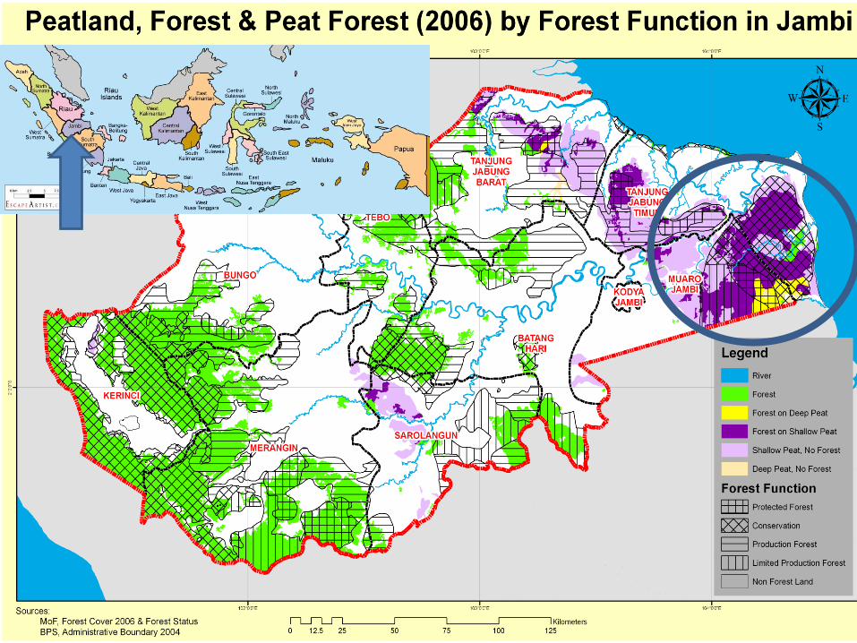
Example of coastal lowand peat swamp Berbak Landscape
Muaro Jambi District, Jambi Province,
Sumatra, Indonesia
20

RIMBA corridor landscape proposed by WWF across the Batanghari river basin, showing village settlements

A sub watershed of the Batang Hari river’s “benang biru” (blue thread)

WHERE?
• Berbak lowland Landscape in Muaro Jambi District, Jambi Province
• The initial priority ‐ Sub‐landscape 1 for GP investment in Sub‐district Kumpeh Hilir that encompasses, – Villages in which are located, • the SFA conservation TAHURA • Non‐state forest / private land or APL
– GP investment sites across the SFA and APL in improved water, forestry, agriculture and fisheries resource management
• Sub‐landscape 2 ‐ HPH (SFA) + APL: see below

BERBAK LANDSCAPE

GP Sub‐landscape 1: TAHURA + APL + river
GP Sub‐landscape 2: HP + APL + river

GP Sub‐landscape 2: HPH + APL + river
GP Sub‐landscape 1: TAHURA + APL + river

WHY? Significant Structure, Function and Value of GP Landscape
A. To reduce RISKS of major carbon emissions and losses in biodiversity that constrain local livelihoods through,
(A1) peat soil degradation (A2) peat land fires that erode forestry resources, both leading to flood‐drought cycles (A3) fueling carbon emissions, (A4) reducing biodiversity
(A5) threatening agriculture, forestry and fisheries Two priority sub‐landscapes where there is the most acute risk of environmental degradation that, • weakens the local economy • Increases poverty • Undermines conservation of a critical ecosystem

Flora and fauna biodiversity under threat

Uncontrolled peat swamp fires

Peat swamps canals too wide, drying out the peat, inviting forest fires

Excessive drainage of peat accelerating excessive drying
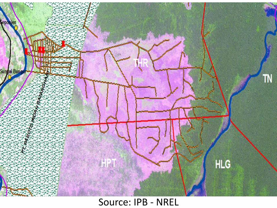
Source: IPB ‐ NREL

2010

Sub‐landscape 1 Sub‐landscape 2
2006
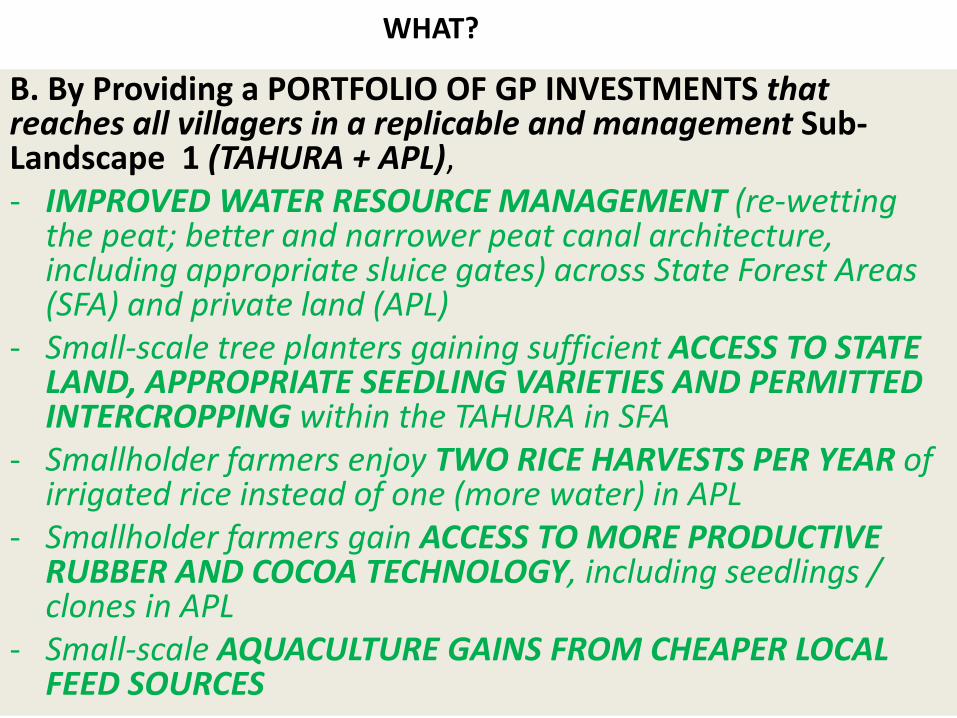
WHAT?
B. By Providing a PORTFOLIO OF GP INVESTMENTS that reaches all villagers in a replicable and management Sub‐Landscape 1 (TAHURA + APL), ‐ IMPROVED WATER RESOURCE MANAGEMENT (re‐wetting the peat; better and narrower peat canal architecture, including appropriate sluice gates) across State Forest Areas (SFA) and private land (APL)
‐ Small‐scale tree planters gaining sufficient ACCESS TO STATE LAND, APPROPRIATE SEEDLING VARIETIES AND PERMITTED INTERCROPPING within the TAHURA in SFA
‐ Smallholder farmers enjoy TWO RICE HARVESTS PER YEAR of irrigated rice instead of one (more water) in APL
‐ Smallholder farmers gain ACCESS TO MORE PRODUCTIVE RUBBER AND COCOA TECHNOLOGY, including seedlings / clones in APL
‐ Small‐scale AQUACULTURE GAINS FROM CHEAPER LOCAL FEED SOURCES

Jelutung seedlings that should be intercropped to reduce fire risk and increase land productivity

Pinang potential for intercropping with Jelutung to reduce fire risk and increase land productivity

Rubber (traditional and clonal) as potential intercrop to increase land productivity

Potential for distribution of more productive local sources of rubber oil palm, rubber, livestock and feed stocks

Two harvests of irrigated rice per year instead of one through better water resource managment

Aquaculture potential
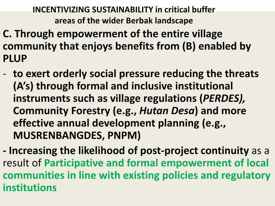
C. Through empowerment of the entire village community that enjoys benefits from (B) enabled by PLUP ‐ to exert orderly social pressure reducing the threats (A’s) through formal and inclusive institutional instruments such as village regulations (PERDES), Community Forestry (e.g., Hutan Desa) and more effective annual development planning (e.g., MUSRENBANGDES, PNPM)
‐ Increasing the likelihood of post‐project continuity as a result of Participative and formal empowerment of local communities in line with existing policies and regulatory institutions
INCENTIVIZING SUSTAINABILITY in critical buffer areas of the wider Berbak landscape

Sub‐landscape 2: Production Forest Concession in SFA and adjacent APL
• Sufficient, village‐wide share of legal logging revenue from production forest concession (HPH) in SFA for social expenditures, e.g., public health, education, civil and religious facilities
• To discourage illegal logging within the (HPH) • Agricultural and fisheries gains for smallholder farmers as for Tahura SFA and adjacent APL, above, including planting of local timber tree species bungur for boat‐building

Legally‐harvested timber within HPH concession
Illegally‐harvested timber within HPH concession

Local timber tree species bungur for boat building

Consequences of Success
• Once success is established as likely through appropriate Impact M&E, continue to other sub‐landscape areas, or,
• Invite other donors to develop remaining sub‐landscapes of the buffer area of Berbak
• Persuading local government to invest in securing the Berbak landscape for sustained growth and poverty reduction beyond donor support