a man, a dam and a disaster: mulholland and the st
TRANSCRIPT

A Man, A Dam and A Disaster: Mulholland and the St. Francis Dam
by J. David Rogers
Introduction FRANCIS DAM WAS BUILT BY THE City of Los Angeles
Bureau of Water Works and Supply in 1925-26 as a curved concrete gravity dam, approximately 200 feet high in San Fran-
cisquito Canyon, about 5 miles northeast of what is now Magic Moun- tain, California. The stated purpose of the dam was to provide an additional 38,000 acre-feet of storage for Los Angeles-Owens River Aqueduct water in close proximity to Los Angeles. The dam failed catastrophically upon its first full filling, near midnight on March 12/13, 1928, killing at least 450 people in the San Francisquito and Santa Clara River valleys. It was the greatest American civil engi- neering failure in the twentieth century.
No less than a dozen separate investigations of the failure fol- lowed, the most cited being the state commission appointed by Governor С. С. Young, which convened on March 19th, made one site visit, and issued their report (known at the time as the "blue book" report) five days later. That board concluded that the dam's failure was most likely ascribable to hydraulic piping of the dam's right abutment, which had been built upon a fault contact between the Sespe conglomerate and the Pelona Schist.1 This somewhat simplistic explanation was offered after observing that blocks from the dam's west abutment were supposedly found further down- stream than those of the opposing, east side.
The failure of St. Francis Dam represents but one of a number of important dam failures that occurred in the 1920s and 30s, when American civil engineers began to push the limits of a technology then in its infancy. The dam's high-profile failure led to the immedi- ate and irrevocable demise of William Mulholland, architect of the Los Angeles water supply system. Like most notorious engineering failures, looking back, we can now take some measure of satisfac-
1
Dow
nloaded from http://online.ucpress.edu/scq/article-pdf/77/1-2/1/248826/41171757.pdf by guest on 27 June 2020
CV

St. Francis Dam Disaster Revisited
tion in knowing that considerable long-term societal benefit result- ed from public outcry following the disaster. Some of the most important consequences included: a) the formulation of the world's first dam safety agency; b) formalization of uniform engineering criteria for testing of compacted earthen materials still in use world-wide; c) a reassessment of all Los Angeles Department of Water and Power dams and reservoirs which led to an extensive retrofit of Mulholland Dam; and d) the formulation of a state-man- dated process for arbitration of wrongful death suits that forms the basis of similar legislation following the 1989 Loma Prieta earth- quake.
In recent years detailed geologic assessments have shown that the eastern, or left abutment of St. Francis Dam was unknowingly founded upon massive paleo mega-slides, developed within the Pelona Schist. The balance of this article explores what is currently understood about the St. Francis disaster by reassessing its failure with modern forensic analytical techniques, most of which were unavailable to civil engineers and geologists in 1928.
Research-to-date suggests that St. Francis was in all likelihood not designed with a proper appreciation of uplift theory; the dam's base width was not as thick as previously assumed; and the design- ers were not aware that the left abutment was a paleo mega-land- slide or that the Sespe red beds would slake upon submersion; and that it was actually pieces of the left (eastern) abutment, against the Pelona Schist, that were actually found furthest downstream fol- lowing the dam's collapse. A review of the available evidence sug- gests the dam failure sequence was likely brought about by a combination of factors, including excessive tilting when fully loaded, an absence of seepage relief in the dam's sloping abut- ments, and the partial reactivation of underlying paleo mega-slides within the Pelona Schist. Uplift forces acting to destabilize the slop- ing abutments would appear to have been similar to those which fostered the disastrous failure of Malpasset arch dam in France in 1959, which took more than five years to sort out and understand (Londe, 1968, 1979, 1970).
2
Dow
nloaded from http://online.ucpress.edu/scq/article-pdf/77/1-2/1/248826/41171757.pdf by guest on 27 June 2020

A Man, A Dam and A Disaster
BillMulholland St. Francis Dam was conceived as an after thought feature of
the original Los Angeles-Owens River Aqueduct by the aqueduct's chief architect Bill Mulholland. In order to unravel the decision- making processes surrounding St. Francis, we first need to under- stand Bill Mulholland and something of the tenor of the times in which he operated.
Most Angelinos are aware of the name Mulholland, which affix- es the prominent roadway traversing the crest of the Santa Monica Mountains above Hollywood. A few locals may also be aware of Mulholland Dam, the official name of the structure that retains Hollywood Reservoir (the dam is virtually identical in design to St. Francis) . But, only a handful of history aficionados are likely aware of the role Mulholland played in creating what was to become the worlďs largest metropolitan area in the years following the Second World War, over a decade after Mulholland had gone to his grave in what was one of the most embarrassing episodes of the city's histo- ry, the failure of the St. Francis Dam.
Bill Mulholland was, simply put, a giant of his time. He embod- ied all of the popular tenets of an American Horatio Alger, who through judicious hard work and self education, rose to become Chief Engineer of Los Angeles water supply system from 1886 until his hastened retirement in 1929.2 A native of Belfast, Ireland, Mul- holland took to the seas at age fifteen, and made landfall in New York as a journeyman sailor four years later, in 1874. After working in Michigan for two years he set out to sea again, eventually arriv- ing in San Francisco in 1877. He worked his way south overland, arriving in the city of Los Angeles later that year. After a year of drilling wells in the vicinity of what is now Compton and Long Beach, Mulholland made an unsuccessful stab at prospecting with his brother adjacent to the Colorado River in western Arizona. He returned to Los Angeles in the spring of 1878 and accepted a job as a "zanjero? ox water ditch tender, with the modest Los Angeles Water Company, one of several private providers of water to the people of Los Angeles.
Mulholland later recalled that he became interested in things technical when serving as a helper on a drill rig digging water wells that pierced a buried tree trunk at a depth of 600 feet. He went to
3
Dow
nloaded from http://online.ucpress.edu/scq/article-pdf/77/1-2/1/248826/41171757.pdf by guest on 27 June 2020

St Francis Dam Disaster Revisited
the library to investigate the manner by which a tree could become buried at such great depth, and read University of California Pro- fessor John LeConte's Introduction to Physical Geology. Mulholland liked the subject matter so much that he later recalled, "Right there I decided to become an engineer" (Kahrl, et ai, 1979). In the apprenticeship tradition ofthat era, he sought an increasingly tech- nical workload and educated himself through reading.
Much of Mulhollanďs success was drawn from his habit of reading the leading technical literature while working with some of the best water resource engineers of the era. His distaste for paper- work was typical of a field man, but it seldom hurt him because of a phenomenal memory. Several years after his death, long-time pro- fessional colleague J.B. Lippincott (1939) would recount that:
When the franchise of the Los Angeles City Water Co. expired in 1898, a valuation of the property became necessary to determine the price to be paid for it by the city. The city employed a Board of Engineers, which included the writer [Lippincott] , to present its case to the arbiters, and this Board called upon Mr. Mulholland, Manager and engineer of the company, for information.
As is frequently the case with people of fine memory, Mr. Mulhollanďs records were not perfect. After the Board of Engineers, as politely as it could, had expressed an opinion that these records were not sufficient for a proper valuation of the property, Mr. Mulholland asked, 'Well, what is it that you want?"
Said one member of the Board: "The thing we want is a com- plete list showing the length of pipe, its size, character, and its age. We also want to know the number of gate valves and all about them, as well as fire hydrants and other structures con- nected with the water system."
Upon hearing this sweeping request, Mr. Mulholland spread out on a drafting table a map of the city and gave from his memory the size, kind, and age of the pipe in every one of the city streets in which it was laid. He also designated the gate valves and hydrants. The Board expressed surprise in his memory, but stated that it did not feel that an inventory made in this way was adequate. Consequently, we indicated, with red circles on the map, 200 places throughout the city where we wished to have the [buried] pipe exposed to view.
Mr. Mulholland was not disturbed in the least over this
4
Dow
nloaded from http://online.ucpress.edu/scq/article-pdf/77/1-2/1/248826/41171757.pdf by guest on 27 June 2020

A Man, A Dam and A Disaster
request. In fact, he seemed rather pleased. He had the pipe dug up in the 200 places indicated; the Board of Engineers actually inspected and classified the condition of all the pipe exposed; and the inspection indicated that Mr. Mulhollanďs memory was correct in every particular. We thereupon accept- ed the complete inventory which he had prepared from memo- ry.
When the city finally acquired the water company's proper- ties in 1902, at a cost of $2,000,000, Mr. Mulholland was retained as manager of the system.
A natural leader blessed with considerable charisma, Mulhol- land was also a man of indefatigable principle. We get a glimpse of this character trait in the long-standing feud between himself and his former best friend and colleague, Fred Eaton, who had pur- chased the Long Valley Ranch within the upper watershed of the Owens River, which he intended to sell to Los Angeles for a healthy profit. But, profiting at the public expense was not something a man like Mulholland could accept, and he exerted pressure for the city to hold out on its acquisition of Eaton's ranch land more than thirty years. Today such behavior would be perceived as naive or stub- born, but to a man of principled conscience, such resolution was a vital building block in a life guided by Christian morals and pre- cepts. To men of his character compromise was work of the devil. Perhaps this is why Mulholland could have no part in politics, despite his tremendous popularity and public trust.
Perhaps more than anything else, Mulholland enjoyed a reputa- tion as a person who could get big things done. He possessed a charismatic persona unusual for an engineer, and his workingman viewpoint made him a champion of construction workers and water and power employees. At the zenith of his career he was the highest paid public official in California (Kahrl, et al , 1979) . The personifica- tion of a field general, he surrounded himself with talent. The young engineers he hired, people such as Harvey Van Norman, Edward Bayley, Charles Lee and Ralph Proctor, were men not unlike him- self: hard-working, to a large degree self-educated, and possessing a willingness to work in the field under difficult conditions.3
For Bill Mulholland and the hundreds of civil engineers whom he influenced, their challenge was that of harnessing nature to build a better world. This attitude is perhaps summed best in a eulo-
5
Dow
nloaded from http://online.ucpress.edu/scq/article-pdf/77/1-2/1/248826/41171757.pdf by guest on 27 June 2020

St Francis Dam Disaster Revisited
gy of a fellow California waterworks engineer published by the American Society of Civil Engineers in 1915: "His was a dreamer as well as a worker, and his dreams were of a world made better and brighter when men become wise enough and fair-minded enough to share with the less fortunate the advantages which have fol- lowed the intelligent control of Nature's laws."4To this group of pio- neer engineers, their careers were a natural response to a high moral calling, that of providing water, the very fiber of human exis- tence.
The First Los Angeles Water Crisis The combination of prevailing drought conditions with an
expanding population created an untenable water supply situation in Los Angeles in the late 1890s. In 1898 the privately-held Los Angeles City Water Company lost its franchise to be the sole pri: vate provider to the citizens of Los Angeles (Nadeau, 1993). Acquired by the city in 1902, Mulholland took his vote of confi- dence as the new manager of the Los Angeles Bureau of Water Works and Supply (BWWS) very seriously. Given a free hand, in his first three years (1902-5) he demonstrated his skill and ability as a water resources manager by rebuilding the city's outmoded distri- bution network, cutting the water rates for domestic service in half, and turning a profit of $640,000.
A 1902 water audit revealed that Angelinos had consumed up to 26 million gallons per day (gpd). Mulholland set about installing water meters as a way to reduce consumption and increase operat- ing profits, and the per capita usage was reduced to 200 gpd. But, it was a losing battle because of Los Angeles' skyrocketing popula- tion growth. In 1899, while Fred Eaton was mayor, the city sur- passed the 100,0000 mark in population. By 1904 that number had swelled to 175,000. To those charged with providing water, it was becoming apparent that the Los Angeles basin was incapable of supporting more than about 200,000 people with the water resources within the Los Angeles River's watershed.5
His first test of drought came in 1904, when only 8.74 inches of rain fell on Los Angeles, about half of normal. Having exhausted the underground aquifers within the Los Angeles River watershed, the city was soon envelopedin a water crisis.
6
Dow
nloaded from http://online.ucpress.edu/scq/article-pdf/77/1-2/1/248826/41171757.pdf by guest on 27 June 2020

A Man, A Dam and A Disaster
Los Angeles-Owens River Aqueduct Mulhollanďs water dilemma had been predicted by his old
boss and mentor at the Los Angeles City Water Company, Fred Eaton. Mulholland had succeeded Eaton as General Manager of the water company when Eaton entered consulting in the mid- 1880s. Eaton was appointed City Engineer in 1886, later being elect- ed to that position in 1892. During the drought of 1893-94, Los Angeles recorded only 6.7 inches of rain. As an adjunct activity of his City Engineer duties, Eaton had undertaken a search for alter- native sources of water in the Sierra Nevada Mountains as far north as the Kings River and east to the Colorado River (Nadeau, 1993). In 1892 or '93 Eaton scouted the Owens Valley and informed Mul- holland of its favorable potential as a water source for Los Angeles. At that time the two disagreed as to whether an out-of-area water source would be necessary to meet demands during drought years.
Born in Los Angeles, Eaton understood the bitter effects of extended droughts in the Los Angeles Basin better than most. Los Angeles had experienced a number of serious droughts. One of the worst had been that of 1875-77, which decimated the local cattle and sheep industries. (Mulholland had arrived in Los Angeles just after this, in 1878.) In 1899 Eaton became the first native-born mayor of Los Angeles, serving for two years. According to Heinly (1910), Eaton had purchased some ranch property in the Owens Valley area in the late 1880s, but other records would suggest his initial purchases were in 1905.6
By 1904 the water situation was changing fast in the Owens Val- ley. In August of that year Eaton accompanied J.B. Lippincott and J.C. Clausen of the newly-formed Federal Reclamation Service7 on a tour of the Owens River watershed, which had been under study by Clausen for the Reclamation Service over the previous year. Lip- pincott, already a veteran water resources engineer in and around the Los Angeles Basin, was the Reclamation Service's Southwest Bureau Chief. After a favorable reconnoiter of the Owens water- shed, Eaton returned immediately to Los Angeles, likely carrying the news that the dream of securing any options on Owens River water would soon evaporate if the reclamation study proceeded to culmination and adoption. All lands then under study by the Recla-
7
Dow
nloaded from http://online.ucpress.edu/scq/article-pdf/77/1-2/1/248826/41171757.pdf by guest on 27 June 2020

St. Francis Dam Disaster Revisited
mation Service were held by the U.S. Department of Interior under the tenets of the 1902 Reclamation Act. К the city didn't move quick- ly, they might lose any chance of securing any legal right to the water. The political realities of gaining such a legal foothold were nothing new to the Angelinos, who had been embroiled in lawsuits with San Fernando Valley ranchers over the latter's drafting of groundwater which they claimed would have otherwise flowed into the Los Angeles River. Mulholland had won this hard-fought battle, but only by convincing the courts of Los Angeles "Pueblo rights," which enabled the city to lay claim to underground as well as sur- face flows of the Los Angeles River.
Judging from the response, Eaton's warning must have been heeded. By September 25th, Eaton was back in Owens Valley, this time with Bill Mulholland in tow (and they kept a low profile amongst the locals in the valley). Their trip appears to have been made solely to reconnoiter the feasibility of siting an aqueduct to carry Owens River water south across the Mojave Desert and San Gabriel Mountains to Los Angeles. Mulholland appears to have been thoroughly convinced by this initial September 1904 recon- naissance that an aqueduct could be constructed.
On paper, the idea of an engineered conduit utilizing gravity flow had several design advantages over any of the competing rivers then under consideration.8 Owens Lake, the terminus of nat- ural flow, lay at an elevation of 3,560 feet above sea level, far above downtown Los Angeles' elevation of only 300 feet. With 233 miles of run (from an intake 12 miles north of Independence near elevation 3,900) , an hydraulic grade of over 15 feet per mile was thereby real- ized, far above what anyone else had ever had to work with in the famous New York aqueducts.9 This surplus in theoretical hydraulic energy head meant that siphons and pressure tunnels should be able to traverse even the most difficult terrain.
Mulholland went back to his governing Board of Water Com- missioners and requested $1.5 million for engineering studies. That these monies were so quickly advanced was likely due to a combination of factors: the city's current water crisis; Eaton's advance groundwork; and the looming threat of the Reclamation Service's studies then underway. That Mulholland could ask for such a sum and be given it without hesitation attests to both his
8
Dow
nloaded from http://online.ucpress.edu/scq/article-pdf/77/1-2/1/248826/41171757.pdf by guest on 27 June 2020

A Man, A Dam and A Disaster
political clout and the desire of his Commissioners to secure new sources of municipal water.
In the spring of 1905, the Board of Water Commissioners appoint- ed a Board of Engineers to investigate the available sources of addi- tional water for the city. This panel consisted of Mulholland, J.B. Lippincott and O.K. Parker. The appointment of Lippincott was like- ly more than a convenience, given his position with the Reclama- tion Service then studying many other watersheds, including that of the Owens River. The panel went on record as having considered all the "alternatives," including the watersheds of the San Gabriel River (283 square miles of watershed) , Santa Ana River (728 square miles), Mojave River (211 square miles) and the Kern River (2,345 square miles) . Of these, the San Gabriel and Santa Ana waters were largely already developed, but the waters of the Mojave were rela- tively unclaimed. But, the Mojave only flowed during spring snow- melt, so any attempt to corral its waters would require a massive storage reservoir in Mojave Canyon, on the back side of the San Bernadino Mountains. The Kern River had a sizable drainage, but its waters were also claimed by ranchers within the southern San Joaquín Valley and it lay on the other side of either Tejon or Tehachapi passes, both over 4,000 feet elevation.
But, the Owens River exhibited enormous potential. The Owens Valley watershed, hundred miles long and five to twelve miles wide, encompassed a whopping 2,629 square miles of watershed. Its ter- minous at Owens Lake was several thousand feet above Los Ange- les, with one major mountain range to cross of slight elevation in comparison to the Tehachapi, Tejon or Cajon passes. Suddenly, Mulhollanďs modest water bureau was dreaming some big dreams. In fact, Mulholland had never attempted the construction of such major facilities as pressure tunnels and inverted siphons, necessary components of such a grandiose scheme. However, his task was clear from the outset: he was purposing to secure sufficient water to support a city of 390,000 persons with an average per capita usage of 150 gpd, requiring 58 million gpd.10 Though not nearly the capacity of New York's new Croton Aqueduct (which carried up to 340 mil- lion gpd) , an aqueduct 250 miles long was simply unprecedented at the turn of the century, when very little in the way of mechanized construction equipment existed. The length alone seemed impracti- cal to most critics, who noted that the longest of the many Roman
9
Dow
nloaded from http://online.ucpress.edu/scq/article-pdf/77/1-2/1/248826/41171757.pdf by guest on 27 June 2020

St Francis Dam Disaster Revisited
aqueducts, that at Marcia, had measured but 58.4 miles (DeCamp, 1990).
Mulholland appears to have been little perturbed by his own lack of experience in the challenge before him. Being self-taught, he was a prodigious reader of the technical literature, and the litera- ture was rife with reclamation and water supply articles during that era. Constrained by natural resources, New York's phenomenal growth had only been accomplished through the construction of great aqueducts. Between 1885-93 the New York engineers had succeeded in constructing a new Croton Aqueduct. The new Cro- ton was constructed as a near-continuous pressure tunnel, an engi- neering first, 45 miles from end to end. The technological marvel of the line was an inverted siphon nearly 7 miles long extending 420 feet below hydraulic grade across the Harlem River.11 Inverted siphons, steam-powered shovels and gasoline powered tractors were recent technological triumphs that would allow for an Owens River aqueduct to become reality.
Peer Review The design of the aqueduct drew upon much of what had
recently appeared in the civil engineering literature, attesting to Mulhollanďs habitual perusal of the professional articles, as only a self-learned man could have maintained in his mid-career years (he was fifty at the time). But, Mulhollanďs earliest challenges lay in securing the trust for such a mighty undertaking: first from the city's political base, then from bond measures passed by the elec- torate in June 1907.
The dream of a mega-scale aqueduct drew critics from the out- set. Other engineers, newspaper editors and electric power inter- ests were quick to point out the unprecedented scale of the project and Mulhollanďs lack of substantive experience in constructing such facilities, much more challenging than a bunch of buried pipes and some wells in the Los Angeles River's dry wash. They also asserted that the project was a desperate gamble, that its fail- ure could place the entire city in receivership.
Prior to the bond election, the Commissioners resolved to elim- inate as much criticism as possible. Responding to technical con- cerns and critiques voiced in the newspapers by other engineers,
10
Dow
nloaded from http://online.ucpress.edu/scq/article-pdf/77/1-2/1/248826/41171757.pdf by guest on 27 June 2020
A Man, A Dam and A Disaster
the Commissioners appointed an Aqueduct Advisory Board, com- prised of three eminent consulting engineers: John R. Freeman, James D. Schuyler and Frederick P. Stearns. Their charge was to make an independent evaluation of the proposed aqueduct design. Lucky for the Angelinos, the board included one giant name in water resources engineering at that time, John R. Freeman.12 The board made an independent technical review of the project's design feasibility, constructability, pricing and logistic require- ments. The selection of such an outside panel of experts by a public agency was something of a novel safeguard at that time,13 but was likely modeled after a similar body that had recently been appoint- ed by President Theodore Roosevelt to provide similar overview of the Panama Canal project then just getting underway (John R. Freeman and CE. Grunsky, a name we shall visit upon later, both served on this prestigious board, appointed by the President) . The external board of consulting engineers found the aqueduct "admirable in conception and outline" in their report released dur- ing the fall of 1906. Few engineers dared to criticize the project after the panel's review was released, due in large part to the clout and credibility of John R. Freeman, who had been one of the princi- pal architects of New York's new Croton Aqueduct. Freeman sub- sequently designed the Hetch Hetchy water supply system for San Francisco in 1909-12.
Design ofthe First Aqueduct Despite the great distance to be traversed, Mulholland's route
enjoyed favorable topography over much ofthe 233-mile transect. The path was almost wholly controlled by California's extensive system of earthquake faults. The linear eastern escarpment of the Sierras is controlled by the Owens Valley or Sierra Nevada fault, which had fostered a Richter Magnitude 7.8 quake in 1872, when the mountains lifted as much as 23 feet, leveling every structure in the town of Lone Pine (Toppozada, Real and Parke, 1981; DWP, 1991). The high eastern crest ofthe Sierra massif is uplifted along this fault, leaving Owens Valley as a deep linear chasm extending some 100 miles, from 12 miles above Bishop, south to Olancha (opposite Owens Lake) .
The original aqueduct was to draw water from the Owens River at headgates about 12 miles north of Independence (about halfway
11
Dow
nloaded from http://online.ucpress.edu/scq/article-pdf/77/1-2/1/248826/41171757.pdf by guest on 27 June 2020

St. Francis Dam Disaster Revisited
up the Owens Valley), at an elevation of 3,714 feet above sea level. That the Owens River terminated in the broad flat expanse of Owens Lake south of Lone Pine was an accident of geology. Vol- canic activity during the Ice Ages (Late Pleistocene time) within the Coso Range of hills between China and Owens Lakes had infilled the southern end of the Owens Valley. The natural obstruc- tion formed by this lava dam had created Owens Lake, just upstream of the closure. The river's sediment soon infilled the newly formed basin, creating a lake of just over 100 square miles in area, but with a maximum depth of no more than 40 feet. Like the Saltón Sea or Mono Lake of today, water which collected in Owens Lake was subject to considerable evaporation, leaving evaporite salts along a receding shoreline.
But, Owens Lake also had a natural outlet. During those years when runoff exceeded the basin's ever-diminishing capacity (due to sedimentation) , the excess overflowed the Coso volcanics at the site of the old lava dam at the extreme south end of the lake. This overflow carved the sculptured potholes of the lower Owens Gorge, and the river intermittently flowed through Rose Valley, across another series of lava dams at Little Lake, and into Indian Wells Valley, which contains China Lake at its eastern end.
It was in the overflow channel just above the lower Owens Gorge waterfalls that Mulholland and Lippincott decided to build their regulation reservoir, known as Haiwee Dam and Reservoir. A regulation reservoir was needed to control discharge quantities into the covered sections and siphon crossings so numerous between the Owens Valley and Mojave.
From its intake north of Independence south to Haiwee the aqueduct was constructed mostly as an open channel canal. South of Haiwee the valley narrows and the route traverses more rugged country. Here the aqueduct was built as a cut-and-cover box chan- nel. Most of the flatter sections were built with rail-mounted steam shovels, thanks to the construction of a standard gauge rail line constructed between May 1908 and October 1910, extending northward from Mojave to the Owens Valley. A total of 320,000 tons of construction hardware would be carried along this line before the aqueduct was finished. The rail-mounted steam shovels dug box-shaped channels which were immediately lined with concrete.
12
Dow
nloaded from http://online.ucpress.edu/scq/article-pdf/77/1-2/1/248826/41171757.pdf by guest on 27 June 2020

A Man, A Dam and A Disaster
More than a million barrels of Portland cement were needed to line the canals, tunnels and cut-and-cover sections. Assistant Chief Engineer J. B. Lippincott engaged in some local geologic studies and discovered requisite quantities of limestone for calcining cement at Monolith, about 17 miles above Mojave, along the rail line crossing Tehachapi Pass.14 Los Angeles was also able to utilize this same site for aggregate production, loading all materials on the Southern Pacific railhead located adjacent to the plant.
Along the western slope of Indian Wells Valley (which contains Inyokern), a series of inverted siphons was necessary to cross steeply incised ravines emanating from the southern Sierras and the Garlock fault zone, which creates the natural escarpment about 10 miles north of Mojave. These ravines were dry, but subject to flash flooding and debris avalanches during infrequent storms. The "queen" of the siphons was at Jawbone Canyon, about 20 miles north of Mojave. Here the siphon pipe was 7,000 feet long and dropped 850 feet. The siphons required huge sections of riveted ductile iron pipe had to be fabricated in Pennsylvania steel mills and trans-shipped to the southern California desert, and pulled by 52-mule teams up to the deep canyons north of Mojave.
When water was introduced into these siphons in early 1913, the one at Sand Canyon (10 miles south of Little Lake) immediately leaked and experienced hydraulic uplift, causing the conduit to lift up out of the canyon slope and become entangled in a landslide spurred by the seepage. This experience (understanding uplift forces) was a harbinger of things to come at St. Francis fifteen years later. Correcting these problems with the siphons added half a year to the completion schedule.
Southwest of Mojave the aqueduct was back on an easier path, skirting the foot of broad alluvial fans coming off the southern Tehachapi Range. The aqueduct dipped underground in several places, and crossed the western apex of the Antelope Valley in a broad siphon that dropped from 3,100 to just below 2,850 feet. It then ran covered along the base of the valley's linear southern escarpment, created by the San Andreas fault. It was this section of the San Andreas that had spawned the January 1857 Ft. Tejon quake, with up to 31 feet of right-lateral ground offset. With an esti- mated Richter Magnitude 7.9 ferocity (Toppozada, Real and Parke,
13
Dow
nloaded from http://online.ucpress.edu/scq/article-pdf/77/1-2/1/248826/41171757.pdf by guest on 27 June 2020

St. Francis Dam Disaster Revisited
1981), this quake, along with the 1872 Owens Valley event, were two of the three largest earthquakes ever recorded in California.
Just opposite Lake Hughes and Elizabeth Lake, natural sag ponds in the San Andreas rift, lay the most difficult challenge of the entire project, the 5-mile long Elizabeth Lake tunnel, between ele- vations 3,030 and 2,980. A hard rock tunnel piercing granite, the tunnel was advanced from either end simultaneously. On several occasions disasters loomed, especially in crossing the fault But Mulhollanďs novel employment of a quota system of 8 feet per day with cash bonuses for exceeding the quota suddenly swung the project ahead of schedule, the miners even setting a hard-rock tun- neling advancement record of 604 feet in one month (Davis, 1993; Nadeau, 1993). Nevertheless, Mulhollanďs innovation always seemed to preserve the construction schedule.
About three miles beyond the south portal of the Elizabeth Lake Tunnel the aqueduct drops almost 900 feet into upper San Francisquito Canyon at what later became Powerhouse No. 1 (completed in 1917). The aqueducťs path then entered a series of tunnels excavated within the Pelona Schist beneath the south slope of the canyon, several hundred feet above the valley floor. At Pow- erhouse No. 2 (completed in 1920) the aqueduct drops another 485 feet, again into the floor of San Francisquito Canyon. These were the two largest drops along the 233 mile course of the original aque- duct.
At Powerhouse No. 2 the aqueduct re-entered the southeast canyon wall as a continuous tunnel, which crossed over into Dry Canyon (where Dry Canyon Reservoir was later built). Here the line crossed Dry Canyon and entered tunnels within the hills bounding the east side of what is now Santa Clarita, then crossed Bouquet Canyon and the Santa Clara River within Soledad Canyon via 10-feet diameter siphons. Returning to tunnel about a mile south of Soledad Canyon, the line soon pierced the San Gabriel fault, one of the prominent structures within the San Gabriel Moun- tains (since found to be geologically active). Then the tunnel turned southeast, still shallow enough to require siphon crossings of Quigly and Placenta canyons.
The last hurdle was the tunnel between Placerita Canyon and south front of the San Gabriel range, just east of the mouth of [San]
14
Dow
nloaded from http://online.ucpress.edu/scq/article-pdf/77/1-2/1/248826/41171757.pdf by guest on 27 June 2020

A Man, A Dam and A Disaster
Fernando/Fremont Pass. Here the mountains were lifted abruptly along the Santa Susana thrust fault. San Fernando Reservoir, which lies a mile beyond the aqueduct terminus, was originally construct- ed between 1911-17, then raised on four subsequent occasions (which will be discussed later). This embankment was unfortu- nately situated upon the Northridge Hills fault which ruptured in 1971, failing the dam.
The logistical tether, panics with the New York public bond financing market, tunneling problems and suction breaks during priming of the inverted siphons, controlled much of the construc- tion schedule. But, the entire project came in on-time and on-bud- get, due in large part to Mulholland's ability to be innovative in problem solving and his charismatic motivation of those who worked for him in the giant undertaking.
Approximately 30,000 people had gathered to watch the first Owens water flow down the open channel aeration cascade at the mouth of Fernando Pass on opening day, November 5, 1913.15 At the time of its completion it was the longest aqueduct in the world. It could transport 258 million gallons of water every day, all by power-free gravity flow. And, the hydroelectric power that would be generated along the lower end of the aqueduct would eventually pay for the entire project. It was, simply put, an accomplishment which drew notice the world over.
The aqueducťs completion brought an unceasing stream of praise to Mulholland. Newspaper editors urged Mulhollanďs can- didacy for mayor, and the University of California (Berkeley) bestowed an honorary doctorate upon him in 1915. But, Mulhol- land had no interest in things political, and crowds roared with laughter when, in response to a probing question as to his possible candidacy, he told a crowd: "Gentlemen, I would rather give birth to a porcupine backwards than be mayor of Los Angeles" (Nadeau, 1993, p. 49) . The response was classic Mulholland, and his aura was beginning to take on an almost mystical sense. He was the quintes- sential personification of the "Chief," a title that remained his nom de guerre within the water department for the balance of his career.
15
Dow
nloaded from http://online.ucpress.edu/scq/article-pdf/77/1-2/1/248826/41171757.pdf by guest on 27 June 2020

St Francis Dam Disaster Revisited
Growth and Drought in the Early '20s
During the city's initial fight to secure Owens River water in 1906, President Theodore Roosevelt had been brought into the fray over the seemingly hasty abandonment of the U.S. Reclamation Service's plan for the Owens Valley. Roosevelt had sided with the city on the grounds that no water from the aqueduct would ever be offered to private interests for resale as irrigation water outside of the city's limits. This was a clear signal to those public services and water commissioners who had purchased extensive land holdings in the semi-arid San Fernando Valley north of Los Angeles proper. The San Fernando Valley land speculators responded to Roo- sevelt's restriction by pushing for annexation of virtually the entire valley area between 1914-23, quadrupling the area of Los Angeles. In 1913 only 3,000 acres had been under cultivation in the valley, but by 1917 that value had risen almost exponentially to 75,000 acres. Suddenly, Los Angeles was becoming an agricultural empire, thanks to aqueduct water.
The Angelino's thirsts were quenched - at least for awhile. Between 1900-20 the population had more than quintupled to 576,000. In the years following the First World War (1914-18) Los Angeles continued to grow, at a rate in excess of 100,000 per year. By 1924 the area of Los Angeles had increased to 407 square miles. During the 1920s the population continued to grow, reaching 1,238,000 by 1930. Los Angeles had not only become the largest city in the American west, it was now also the fastest growing city in America (World Book, 1933).
During the aqueducťs first year of operation Los Angeles received 23.65 inches of rainfall, about 160 percent of normal. But, rainfall in the winter immediately following the November 1918 Armistice (1918-19) was a near-record low, only 6.67 inches of rain. This gave everyone a scare, but was followed by two successive years of above-average rainfall. The post-war land boom was in full swing when an unprecedented series of dry years began in 1922-23, when only 9.59 inches of rain fell. This was followed by 6.67 inches in 1923-24 and only 7.94 inches in 1924-25 (average rainfall over the period of 1877-1992 has been 15 inches annually) . Los Angeles had never seen a three-year drought of such magnitude before.
The effects of the drought stretched into the eastern crest of
16
Dow
nloaded from http://online.ucpress.edu/scq/article-pdf/77/1-2/1/248826/41171757.pdf by guest on 27 June 2020

A Man, A Dam and A Disaster
the Sierra Nevada. By the spring of 1923 Haiwee Reservoir was at an all-time low level, 8,000 of its 58,500 acre-feet of capacity. During this first year of the 1922-25 drought San Fernando Valley ranchers used an average 45 percent of the aqueduct water, but that portion began to soar as the drought dragged on. It wasn't long before Mul- holland had another water crisis on his hands.
Mulholland had engineered the aqueduct to serve 50 years of anticipated growth, but he had underestimated two factors: the rate of expansion, which was unprecedented, and the seasonal fluctua- tion of the Owens River. At the height of the 1922-25 drought, the Owens River flow dropped to 262 cubic feet per second (cfs) , while the aqueduct was capable of carrying 485 cfs (average flow prior to the drought had been 355 cfs). The San Fernando Valley ranchers were drafting up to 277 cfs, or 100 percent of the river/aqueducťs base flow during such conditions. As the drought wore on, Mulhol- land was forced to steadily reduce the rancher's share of the dimin- ishing aqueduct discharge. The ranchers, seeing their livelihoods evaporating, began to panic and did everything in their power to exert political pressure for more water.
Under enormous pressure from the Board of Public Service Commissioners to alleviate the water crisis, the Bureau of Water Works and Supply (BWWS) attempted to acquire additional Owens River watershed upstream of the 1913 intake (which was 12 miles north of the Inyo County seat of Independence). Their initial tar- gets were those ranch lands with established water rights and irri- gation ditches drafting flow from the Owens before it reached the city's intake. Ranchers soon got word of impending sales and held out for exorbitant prices, while local merchants feared for their businesses should the ranks of the ranchers began to diminish. In late 1922 dissent had intensified sufficiently so as to cause some Owens residents to band together to formulate an irrigation district to protect their remaining water under the tenets of the state's 1884 Wright Act (which created the legal process for establishing irriga- tion districts, and thereby, securing a bindable legal title to water rights such that waters could not be transferred out of the district) .
When the city's agents purchased some of the key tracts, mak- ing their owners financially independent (over $3 million was spent for Owens Valley acquisitions in 1924 alone) , the ranchers began to
17
Dow
nloaded from http://online.ucpress.edu/scq/article-pdf/77/1-2/1/248826/41171757.pdf by guest on 27 June 2020

St Francis Dam Disaster Revisited
break ranks. Those whose lands abutted some of the prime river- bank and irrigation ditches commanded top dollar, while those left out of the buy-out flooded fallow fields with as much water as possi- ble, just to keep it out of the Angelino's hands. For their $3 million in hasty purchases, BWWS got almost no additional water. In mid- 1923 the residents of Big Pine became more proactive, taking a con- struction camp hostage and throwing the city's equipment into the Owens River. After attempts by San Fernando Valley ranchers to purchase Owens water independently fell through, the first dyna- miting of the aqueduct began in May 1924. This war of occasional sabotage and publicity carried on through the remainder of the '20s and intensified awareness of the Angelino's water woes.
More Reservoirs For a water resources engineer like Mulholland, deliverance,
once again, lay in sorting out the numbers. In making this reassess- ment, several lines of reasoning emerged. In the near term, the simplest answer to droughts was more reservoir storage so surplus flows of the Owens could be transferred by the aqueduct and stored during wet years. Less pressing an immediate need, but more ominous, was the revelation that even the entire flow of the Owens River could not meet revised growth estimates for the Los Angeles area.16 For a while, Mulhollanďs salvation looked to be the rising water table of the now fully-irrigated San Fernando Valley. After seven years of irrigation, BWWS estimated that approximate- ly 150,000 acre feet of groundwater now lay beneath the valley. Groundwater consultants estimated that 25 to 35 percent of this water could be recovered from a system of wells during drought years. For water well drillers, the drought was a bonanza. But, BWWS knew that they could easily draft more water than could be recharged in the valley for this had been the pattern in the 1890s when the city was forced to sue over overdrafting by local ranchers.
By modern standards, the original aqueduct had been con- structed with the lion's share of the storage capacity at the head end, at Haiwee, which had a maximum capacity of 60,000 acre-feet, and Fairmont, at the head end of the Elizabeth Tunnel, with a capacity of 7,500 acre feet.17 The total combined storage of these reservoirs represented only 112 days of mean base flow, hardly
18
Dow
nloaded from http://online.ucpress.edu/scq/article-pdf/77/1-2/1/248826/41171757.pdf by guest on 27 June 2020

A Man, A Dam and A Disaster
enough to meet the shortfalls of a multi-year drought such as Los Angeles faced in the early 1920s. In addition, both reservoirs were situated north of the ominous San Andreas Fault. A repeat of the 1857 Ft. Tejon quake could be expected to sever the Elizabeth Tun- nel, thereby truncating access to this storage until such time that Fairmont was drained and the tunnel repaired (which could take more than a year).
South of the San Andreas, there was Dry Canyon (1,140 acre feet); [Lower] San Fernando (then 11,000 acre feet); Chatsworth 2 and 3 (9,850 acre feet); Upper Franklin Canyon (123 acre feet); Sil- ver Lake (2,162 acre feet); Bellevue (107 acre feet); Elysian (166 acre feet); Buena Vista (40 acre feet); Solano (17.5 acre feet); Haz- ard (8 acre feet); Mt. Washington (0.9 acre feet); Highland (61 acre feet) ; Garvanza (2.3 acre feet) ; San Pedro (26 acre feet) , and Wicks [Rowenna] with 93 acre feet for a total storage capacity of 24,796 acre feet, only 27 percent of the city's then-available storage.
Up until that time the long range goal of Mulholland had always been to build the Long Valley Dam, retaining an enormous reser- voir above the Owens River Gorge upstream of Bishop. It was another 90 miles north of where the 1913 aqueduct had begun, and it was the property owned by Fred Eaton. Eaton held out for $900,000, but the city only offered $225,000. As the drought wore on and Los Angeles water problems steadily worsened, Eaton raised the ante to $1.5 million, then to $3 million. Mulholland told Van Norman,"the City will buy Long Valley three years after Eaton dies" (Davis, 1993). It was strangely prophetic.
With their dream of building Long Valley indefinitely on-hold, Mulhollanďs water bureau worked feverishly through 1921-23 to survey, design and begin construction of additional storage facili- ties, all within close proximity of Los Angeles and south of the San Andreas fault. What resulted was a second generation of reservoir construction, aimed at completing 67,000 acre feet of additional storage, increasing local storage capacity by almost three-fold.
Construction began on Stone Canyon Dam in the Santa Monica Mountains above what is now Bel Aire Estates in 1921. A tabulation of the major reservoir projects in the early 1920s is summarized in Table 1. Though impressive in scale, the reservoir construction program would come too late to save the San Fernando Valley
19
Dow
nloaded from http://online.ucpress.edu/scq/article-pdf/77/1-2/1/248826/41171757.pdf by guest on 27 June 2020

St. Francis Dam Disaster Revisited
crops during the 1923-24 season when the drought returned after a brief respite the year previous. This ambitious program of capital works improvements received an infusion of funding between 1921-26, with all of the design work completed by mid-1923 (23rd Annual Report of the Board of Public Service Commissioners, 1924). From the fall of 1923 BWWS's attention turned to the Col- orado River surveys ,18
Table 1 Dams Designed and Built Between 1920-26 by Los Angeles
Bureau of Waterworks & Supply
Reservoir Capaci- Years of Con- ReservoirName Height D am Type ty acre-feet struction
J^T? Franklin I 96feet LhydíafC?}| & rolled earth 1,050 I 1921-22 Franklin & rolled earth
Stone Canyon rolled earth 147 feet 8,000 1921-24
Upper San g2feet hydraulic fill 1,850 1921-22 Fernando additional
Lower ban raised f ^^ fiU 3 m tQ i924-25 Fernand0 14,670
Encino 135 feet hydraulic fill 3,229 1921-24
Sawtelle 34 feet rolled earth 103 1923-24
Ascot 73 feet rolled earth 219 1925-26
Hollywood y 200 feet concrete 7m 1923-25 y | | gravity I I
In his 1924 annual report, Mulholland stated that it was his desire to construct reservoir storage sufficient for an entire year's supply of water for Los Angeles. This storage was to be within immediate proximity of the city, south of the ominous San Andreas Fault (24th Annual Report of the Board of Public Service Commis-
20
Dow
nloaded from http://online.ucpress.edu/scq/article-pdf/77/1-2/1/248826/41171757.pdf by guest on 27 June 2020

A Man, A Dam and A Disaster
sioners) . To accomplish this goal, five new reservoirs were built and two existing structures were enlarged. The largest of these struc- tures was to be the dam situated between the aqueduct powerhous- es in San Francisquito Canyon, which was to store 32,000 acre feet, or about half the capacity of the ambitious expansion program.
Selection of the St. Francis Dam Site
Originally, the BWWS thought the site of the "big dam" would be in the Big Tujunga Canyon, above what is now Sunland (Lippin- cott, 1941) . But, when the city went to court to begin condemnation proceedings, much adverse testimony was introduced to inflate the value of the ranches to be affected. In Mulhollanďs view, what should have proceeded as a fair recompensation had turned into another attempted hold-up of the city purses in the likeness of Owens Valley. Mulholland decided to cease the condemnation action and seek another less expensive site. He knew of an ideal site, one which he had explored in some detail eleven years before.
During construction of the aqueduct Mulholland had visual- ized a dam site along San Francisquito Creek, adjacent to the San Francisquito Canyon Construction Camp, which had been built within a broad alluvial flat located about halfway up the canyon to house the men working on the 6-1/4 miles of tunnels along San Francisquito Canyon (between what later became the two power- houses). The topographical character of this area was unusual in what was otherwise a linear fault-controlled canyon with steep sideslopes. A natural dam site existed where the canyon suddenly narrowed, just downstream of the broad wooded flat where the construction camp had been located (Figure 1) .
Mulhollanďs attraction to the St. Francis dam site was linked to what he perceived as favorable topography: a natural narrowing of the canyon downstream of a broad, upstream platform, thereby creating a large water storage area with the minimum possible dam (Mulholland, 1928). He so favored the site early on that he had exploratory adits (horizontal tunnels) excavated into the Sespe conglomerate and water percolation tests performed within these. Though appearing crumbly, the reddish sandstone "passed" the pere tests 19 (Mulholland, 1928) .
Mulholland also appears to have appreciated the potentially
21
Dow
nloaded from http://online.ucpress.edu/scq/article-pdf/77/1-2/1/248826/41171757.pdf by guest on 27 June 2020

St Francis Dam Disaster Revisited
treacherous nature of the mica schist comprising the southeast wall of San Francisquito Canyon. In his Sixth Annual Report of the Bureau of the Los Angeles Aqueduct to the Board of Public Works in 1911, Mulholland had stated:
As the face of the canyon opposite the lower power line [the aqueduct line between Powerhouse No. 1 and Powerhouse No. 2] is exceedingly rough, and the dip and strike of the slate such as to threaten slips, in case side-hill excavation were made, this portion of the line was also placed well back under the mountain and will be constructed from adits [tunnels] run in from the canyons [parallel and beneath the canyon walls] ... (quoted from Outland, 1963, p. 37)
It was in such statements as these that Mulholland displayed his notorious insights for things geological. The schist [slate] was slippery, and the slopes were comprised of old landslides. He also correctly ascertained that making traditional side-hill excavations upon which to place the aqueduct would have been unwise.
DWP records indicate that the dam site and reservoir area were quietly surveyed in December 1922. After the dam's failure, Mulholland would recall that he had taken Stanford geology pro- fessor John С Branner out to see the dam site in 1922, before the survey or any engineering designs had been completed or any out- siders realized what BWWS had in mind.20
Unbeknownst to Mulholland, the reasons for the favorable topography of the dam site lay in the fact that this portion of the canyon had already served as a natural reservoir due to damming of San Francisquito Creek by large prehistoric landslides devel- oped within the Pelona Schist along the southeastern canyon wall. The seemingly-intact Pelona Schist had actually rotated downward onto the opposing bank of Sespe conglomerate, thereby blocking the canyon and creating a large landslide dam (Figure 1). The waters of San Francisquito Creek had eventually overtopped the landslide dam and re-excavated a channel. The broad flat area, seen by Mulholland as an excellent reservoir site, had actually been cre- ated through sedimentation behind the paleo landslide dam. Evi- dence of the paleo slides and the impounded lake is clearly seen today in the form of stepped terraces along the Pelona escarpment (Figures 1, 15 L,and 16 L) .
22
Dow
nloaded from http://online.ucpress.edu/scq/article-pdf/77/1-2/1/248826/41171757.pdf by guest on 27 June 2020

A Man, A Dam and A Disaster
Earth vs Concrete forthe Dam
By 1923 Bill Mulholland was an old hand at the design and con- struction of municipal dams and reservoirs. He and James D. Schuyler had been the founding fathers of hydraulic fill embank- ments, a construction methodology born out of hydraulic mining.21 Like hydraulic mining, hydraulic filling utilized water fed through hoses to small diameter nozzles, generating a high-velocity orifice flow capable of sluicing earth and rock debris from a dam's natural abutments into the canyon bottom where slight inclines could be maintained that would force "zoned disposition," or in more collo- quial terms, the coarse sediment would be left on the flanks of the sloping embankment, while fine-grained silt and clay would be "puddled" within a pond maintained in the center of the embank- ment. In this fashion, a relatively impermeable "core" was created at the center of the embankment, a seemingly favorable situation for entrapment of moisture within a dam. Mulholland constructed South Haiwee, Dry Canyon and Lower San Fernando dams as hydraulic fills ancillary to the Owens aqueduct. North Haiwee Dike, Fairmont and Upper San Fernando were built of wagon- hauled fill that was then hydraulically sluiced. Given this range of experience (the South Haiwee, Lower San Fernando and Fairmont embankments had volumes between 500,000 and 700,000 cubic yards), Mulholland served as a consultant on a large number of hydraulic fill dams built between 1910 and 1930, including the enor- mous Gatun Dam that retains Gatun Lake in the Panama Canal.22
Mulholland Dam
Up until 1923, all of the BWWS reservoirs had been earthen embankments. These had generally been placed initially as sluiced hydraulic fills, but when water was scarce or large rocky material encountered, wagon-hauled end-dumped earthen fill was simply hydraulically sluiced to create a semi-impervious core of puddled clay (Kelly, 1916). Rolled fills became more common in the early 1920s as construction equipment became more mechanized. The cap sections of these hydraulic fills were rolled fills, accomplished with early versions of the sheepsfoot roller.
Weid Canyon Dam, impounding Hollywood Reservoir, was to be the city's first concrete dam structure. Begun in August 1923 as
23
Dow
nloaded from http://online.ucpress.edu/scq/article-pdf/77/1-2/1/248826/41171757.pdf by guest on 27 June 2020

St. Francis Dam Disaster Revisited
a 200-feet high curved concrete gravity arch dam, Weid Canyon was christened Mulholland Dam in honor of the "Chief a year before its completion in March 1925.
At this distant date the author can only speculate as to why the change to concrete. In an age before bulldozers and self-propelled scrappers, concrete was a viable alternative to hydraulic earth fills when dam sites were devoid of requisite quantities of clay for a pud- dled core and sufficient water with which to sluice it into place. The water requirements for an hydraulic fill could be substantive. BWWS had generally employed 4-inch diameter canvas hoses fit- ted to 2-inch brass nozzles (Kelly, 1916). Judging from geological conditions at the other project sites then under construction, con- crete was likely chosen over earth because of the relative paucity of clayey material within the abutment materials, basic requisites for any earthfill embankment.
24
Dow
nloaded from http://online.ucpress.edu/scq/article-pdf/77/1-2/1/248826/41171757.pdf by guest on 27 June 2020

A Man, A Dam and A Disaster
Figure 1 - 1927 view looking upstream at St. Francis Dam and reservoir from a knoll in the Sespe sandstone. The main dam section built within San Francisquito Canyon is seen at right. San Francisquito Canyon Road can be seen just above the dam's far abutment, about 10 to 15 feet above the dam crest. The long dike section lies atop a bedrock spur at center picture, while the auxiliary spillway weir crosses the small saddle in left foreground. Mulholland's Franklin touring car sits atop the ridge, to rightmost of the three vehicles, and the "Chief appears to be walking the crest of the dike at right center. The arrows indicate the topographic bench formed within the Pelona Schist by ancient megalandslides, A geologic cross sec- tion through this slope is shown below.
25
Dow
nloaded from http://online.ucpress.edu/scq/article-pdf/77/1-2/1/248826/41171757.pdf by guest on 27 June 2020

St. Francis Dam Disaster Revisited
Design Changes, Construction and Controversy The tendency of ranchers to raise land prices in anticipation of
being bought out by the city's Water Bureau likely served to create an air of secrecy and suspicion amongst those BWWS personnel working on feasibility projects on lands yet to have been acquired by the city. In quiet San Francisquito Canyon Bureau of Power and Light (BPL) personnel were the canyon's primary occupants since completion of the two major hydroelectric power plants along the aqueduct in 1917 and 1920. Both of these facilities remain in service today.
Mulhollanďs office engineering department appears to have prepared preliminary studies of the main St. Francis dam structure in May 1923. The design called for a stepped concrete gravity arch structure, virtually identical in size and layout to Weid Canyon [Mulholland] Dam, which began construction the following August.23 The original design was for a concrete monolith extend- ing some 175 feet above the bed of San Francisquito Creek (shown in lower left of Figure 3) . The original reservoir capacity was to be for 30,000 acre feet of water. In July 1924, the lake's capacity was increased to 32,000 acre feet by adding a small wing dike extending from the west abutment. This increase may have been to account for the inflation in yearly water consumption then being experi- enced.
The city filed a condemnation petition for the proposed reser- voir inundation area with the federal government in April 1924 just as they began construction. The construction superintendent for the project was Stanley Dunham (E.L. Jacques supervised the Weid Canyon [Mulholland] Dam, then still under construction). The first concrete being placed the following August, exactly one year behind the schedule at Weid Canyon. It would appear that it wasn't until January 1925 that the city provided formal public notice as to what it was doing in San Francisquito Canyon.
There were the ranchers and orchard growers downstream who were dependent on the perennial flow of the Santa Clara River. These people drafted their summertime irrigation water out of the Santa Clara River's alluvial gravels. With the drought affecting them as well as everyone else, they began to get nervous. They formed the Santa Clara River Protective Organization and immedi-
26
Dow
nloaded from http://online.ucpress.edu/scq/article-pdf/77/1-2/1/248826/41171757.pdf by guest on 27 June 2020

A Man, A Dam and A Disaster
ately hired Carl E. Grunsky, one of the most prominent water resources engineers ofthat era, who was based in San Francisco.24 Grunsky made an independent assessment of the proposed dam's effect on recharge of the Santa Clara River. He first visited the dam- site to view the construction in March 1925. In his initial report to the ranchers, he noted that "there was no indication of trenching up the hillsides to provide vertical abutment faces" (Outland, 1963, p. 33).
At this early juncture, it would also appear that the city held to its initial premise that the sole intent of the dam was to entrain an "emergency supply" of water, to be derived solely from their aque- duct. In his first report, Grunsky reassured his clients that "the City of Los Angeles did not intend to store the natural waters of San Francisquito Creek," which had a watershed area of 37.5 square miles above the dam. A review of LADWP records suggests that an internal study made two years earlier, in July 1923, indicates that the city was including the runoff from San Francisquito Creek in its storage calculations Getter from BWWS engineer WW Hurlbut to Mulholland, dated July 1, 1923).
In July 1925, after eleven months of placing concrete, BWWS engineers decided to increase the reservoir capacity once again, to 38,168 acre feet, by adding yet another 10 feet to the dam's height. This increased storage was made possible by extending the dam to a height of 195 feet above the creekbed, while raising and extend- ing a concrete dike some 1,300 feet northwest of the dam's right abutment, atop a natural ridgeline in the Sespe (Figure 1) . As in the previous upscaling, this may have been due to increasing rates of yearly water usage at that time in Los Angeles.
The dam had now been raised 20 vertical feet, or 11 percent of its original 175 foot height, without any substantive widening of the dam's base width. This was a potentially dangerous action in a grav- ity dam, which is a retention structure that derives its stability through simple dead weight to resist the force imposed by the reservoir water. Historian Charles Outland (1910-88) had caught this discrepancy in his sleuthful research of the facts surrounding the dam's construction and demise in both editions of his classic text on the St. Francis tragedy (Outland, 1963, 1977). Outland noted in one of the BWWS construction photos that the lowermost
27
Dow
nloaded from http://online.ucpress.edu/scq/article-pdf/77/1-2/1/248826/41171757.pdf by guest on 27 June 2020

St. Francis Dam Disaster Revisited
four "steps" on the downstream face of the dam portrayed in the structure cross section presented by BWWS to the Governor's Board of Inquiry (Figure 3, lower right) simply weren't to be seen in the construction photos. BWWS may have attempted to "scab" these blocks onto the original dam monolith, but such a move, if it did occur, would have been questionable at best. Simply put, it is dangerous to attempt the heightening of a concrete gravity dam simply by increasing the crest height without a corresponding enlargement of the dam's base.
Relief of Uplift Forces The dam structure was completed in May 1926, as shown in
Figure 2. The main section across San Francisquito Creek was designed as a free-standing gravity section. Limited seepage relief was afforded in the design, and only a few uplift relief wells beneath the central core were employed (Figure 3, upper). In addition, no
Figure 2 - St. Francis Dam as it appeared just after its completion in May 1926. It was a curved concrete gravity section, standing approximately 200-feet high and was comprised of 130,000 cubic yards of concrete with- out benefit of any contraction joints, drainage galleries, cut-off walls, or grout curtain. The Pelona Schist made up the east abutment, on the right side of the photo, while the Sespe formation red beds comprised the upper two-thirds of the west abutment (shown at left) . Photo from Huber Collection, University of California Water Resources Center Archives, Berkeley.
28
Dow
nloaded from http://online.ucpress.edu/scq/article-pdf/77/1-2/1/248826/41171757.pdf by guest on 27 June 2020

A Man, A Dam and A Disaster
Figure 3 - Cross sections of St. Francis Dam through the outlet works contained in Block 1, the only section of the main dam to survive the failure. The upper section is a reconstruction by the author. Some uplift protection, in the form of relief wells, had been provided for the central core of the dam, within the stream channel. No such protection was afforded to the sloping abutments. The section at lower left is from the design sections for the original dam, made in 1923. The section at lower right is that provided by the Bureau of Water Works to the Governor's Board of Inquiry following the failure. Note the variance in maximum base width between these representations. It is unlikely that the dam was as wide as portrayed to the public, although the variance may have been unintentional, given the rush with which the drawing at the lower right was produced.
29
Dow
nloaded from http://online.ucpress.edu/scq/article-pdf/77/1-2/1/248826/41171757.pdf by guest on 27 June 2020

St Francis Dam Disaster Revisited
provision had been made for emplacement of expansion joints with- in the main structure. The main portion of the dam was arched upstream, on a 500-foot radius, as depicted in plan in Figure 4. Addi- tional load-carrying capacity due to arch action was neglected in the dam's design, a common and seemingly conservative decision. During the Los Angeles County Coroner's Inquest following the dam's failure, Mulholland would testify that the dam was designed witha"factor of safety of three or four" (Mulholland, 1928, p. 10).
Most of the post-failure investigative panels would cite the gen- eral absence of measures to reduce seepage forces underneath the dam, causing the dam's resultant thrust to lie within the down- stream third of the main dam block (Figure 3 upper). These would have included such features as a deep cutoff wall/trench, a grout curtain to inhibit underdam seepage, and uplift pressure relief wells (of which there were 8 placed beneath the main portion of the dam, which did not fail). These features became requisite compo- nents of masonry dam design a few years later (Creager, 1931; Henny, 1932, 1934; Houk, 1932; Creager, 1934, 1941; Harza, 1935, 1949; Subcommittee, 1952). In the aftermath of the dam's failure, some stinging criticisms of the city's lack of appreciation for the detrimental effects of uplift pressures were also voiced by some prominent dam designers of that era (Bennett, LaRue, Moore, Wiley, Fowler, Ledoux, Grunsky, Gerry and Jorgensen, all 1928; Terzaghi, 1929; Floris, Grunsky and Morris, 1930; and Henny, 1931).
Many engineers were just beginning to appreciate the destabi- lizing effects of uplift pressures in the late 1920s, when the dam failed (Floris, 1928). In lay terms, uplift pressures are caused by bouyance due to simple submergence or percolation. When water fills behind a dam, the dry dead weight of the dam is significantly reduced because of the water pressures within the foundation rock beneath the dam are pushing upward (water pressure pushes equally in all directions) . Estimating the amount of this upward lift- ing is critical to dam stability assessments, as each pound of uplift pressure negates a pound of the dam's seemingly immense dead weight. In addition, as the dam mass becomes saturated, its weight is also reduced through submergence where its bouyant weight equals the weight of water displaced. The critics were quick to
30
Dow
nloaded from http://online.ucpress.edu/scq/article-pdf/77/1-2/1/248826/41171757.pdf by guest on 27 June 2020

A Man, A Dam and A Disaster
Figure 4 (upper) - Plan view of the main section of St. Francis Dam as originally designed from DWP files. Diagonal lines and numbers delineate the dam blocks identified in the post-failure analysis by the Governor's Board of Inquiry (shown in Figure 9). The dam's horizontal steps were each five feet high and varied in plan, from 5.5 feet in the lower part of the structure to as little as 1.5 feet in the upper- most part of of the dam. The unique spacing of the steps allowed for a good deal of forensic puzzle-solving in the post-failure analysis.
Figure 4 (lower) - Same plan view as above, but with the displaced block designa- tions assigned by the Bureau of Water Works (taken from Lee, 1928b). These blocks were identified through a more extensive program of analysis than those of the Governor's Board.
31
Dow
nloaded from http://online.ucpress.edu/scq/article-pdf/77/1-2/1/248826/41171757.pdf by guest on 27 June 2020

Sí. Francis Dam Disaster Revisited
point out that the concrete mix in St. Francis wasn't very good by structural standards: the average mass density of 140 pounds per cubic foot (pcf) was well below the industry standard of 150 pcf (meaning the dam was 7 percent lighter than other concrete dams) and the concrete porosity was around 13 percent because of the poor character of the aggregate gathered from San Francisquito Canyon. Porosities of 3 percent to 5 percent would be considered normal (Troxell, Davis and Kelly, 1968) .
Dams built without percolation cutoff walls, grout curtains and uplift relief wells could be extremely hazardous if the designers were unaware of these effects. Articles on hydraulic uplift beneath dams were just beginning to appear (Floris, 1928) in the profession- al literature, though a number of engineers were aware of uplift (LaRue, 1928). Most dam structures prior to 1928 had been designed and completed with this deficiency (Subcommittee on Uplift, 1952). Anton Floris (1928), Ivan Houk (1932), William Crea- ger (1931,1934, 1941) and LE Harza (1935) pioneered the poten- tially detrimental effects of hydraulic uplift, but it was not until the early '40s that Creager and Harza had assembled sufficient perfor- mance data to convince everyone of their claims.25 In the failure's aftermath, the city's water and power staff would be quietly appraised of their oversight in regards to properly appreciating the effects of uplift (discussed later in regards to Mulholland Dam). Twenty years later, some of the same BWWS engineers who worked on St. Francis would be writing state-of-the-art articles on relief of uplift pressures in dams (Proctor, 1948).
Initial Operation and Filling Owens aqueduct water was first diverted into the St. Francis
reservoir on March 1, 1926, several months before completion. Fill- ing of the St. Francis reservoir was nothing short of dramatic by modern standards, the level rising at an average rate of 1.8 feet per day over the first three months (between March 1 and June 1, 1926). On July 14, 1926, Los Angeles filed an amended application to the California Division of Water Rights specifically requesting appropriation of the canyon's "flood and surplus waters." The out- flow along San Francisquito Creek immediately ceased and the downstream members of the Santa Clara River Protective Associa-
32
Dow
nloaded from http://online.ucpress.edu/scq/article-pdf/77/1-2/1/248826/41171757.pdf by guest on 27 June 2020

A Man, A Dam and A Disaster
tion became predictably incensed. Once again, C.E. Grunsky and his son were hurriedly shuttled south from their San Francisco office to make inquiry on behalf of the Santa Clara Valley ranchers. With the discharge of San Francisquito Creek truncated, down- stream recharge of the river gravels ceased and those ranchers liv- ing downstream began to notice their well levels dropping.
Grunsky reported what he saw and lawsuits ensued shortly thereafter, with the state's Chief of Water Rights Edward L. Hyatt being "called in" to resolve the dispute.26 Hyatt wisely opted for field tests to ascertain the validity of the opposing technical argu- ments. Water was purposefully discharged from the new dam under the watchful eyes of both Mulholland and Grunsky in June 1927. The water emanating from St. Francis Dam only flowed a few miles before disappearing into the stream gravels, affirming the Grunskys' complaint and negating the defense offered by Mulhol- land on the city's behalf. Up until that time, it was one of the rare occasions when Mulholland was publicly embarrassed.27 The city had been out-gunned, but chose to legally appeal, and the matter was still unresolved when the dam burst nine months later.
By May 10, 1927, the St. Francis reservoir pool reached eleva- tion 1,832 feet, three feet below spillway crest (177 feet above the creekbed) . This elevation was held until May 26, at which point the spring runoff ceased, and the reservoir lowered. The dam had not been designed with a surplus of spillway capacity. Spillway slits, built into the main dam section, were only 18 inches high in eleven 20-foot wide bays (seen to good effect in Figure 2) . A detached con- crete emergency overflow spillway weir was constructed on the crest of a natural saddle, beyond the end of the wing dike, approxi- mately 1,100 feet northwest of the main dam section. Seen to good effect in Figure 1, this weir was built as something of an after- thought when the dam was raised the second time.
Cracks in the Dam
During the initial filling of the reservoir in 1926-27, several cracks had appeared, transverse to the dam's axis, in the down- stream face of the main structure. Mulholland termed these "trans- verse contraction cracks," presumably caused by the thermal stresses associated with the curing of the mass concrete (the main
33
Dow
nloaded from http://online.ucpress.edu/scq/article-pdf/77/1-2/1/248826/41171757.pdf by guest on 27 June 2020

St Francis Dam Disaster Revisited
Figure 5 - Schematic elevation view of transverse cracks which appeared on the downstream face of the dam prior to its failure. The four cracks most often described are portrayed, their having been formed by late 1927. Both abutment cracks were angled obliquely, and widest at their junctures with the foundation rock, suggesting abutment uplift. The two longest cracks, in the dam's central sec- tion, were later found to be those bordering Block 1.
34
Dow
nloaded from http://online.ucpress.edu/scq/article-pdf/77/1-2/1/248826/41171757.pdf by guest on 27 June 2020

A Man, A Dam and A Disaster
structure was comprised of 130,500 cubic yards of concrete, placed in just sixteen months) . Two sets of cracks appear to have formed, those on the steeply rising flanks of the structure, and two within the maximum section. The approximate locations of these frac- tures, deduced from verbal descriptions and photographs, are depicted schematically in Figure 5. The flank cracks were observed to be wider at their juncture with the abutments, narrow- ing upwards; while the two longer, main section cracks appeared widest at the top, near the parapet wall. The transverse cracks with- in the main dam block were infilled with hemp and sealed with wedges of oakum on the downstream face. These were then back- filled with cement grout to seal off active seepage.
The Final Filling In February 1928, the lake level again rose to the dam crest and
a number of new springs developed in the foundation, mostly on the west side, within the sandstone and dirty pebble conglomerate beds of the Sespe formation. One of these leaks was observed in vicinity of the fault contact between the red Sespe beds and the Pelona Schist. In this location the Sespe beds had originally been deposited on an eroded surface of the Pelona Schist, nearly coinci- dent with the schisťs slippery micaceous foliation. The paucity of structural distortion more than a few feet into either unit, suggests that the fault formed here in large part due to the dramatic variance in stiffness and deformability of the two distinctly different rock types.
When the spring runoff began arriving in January 1928, the reservoir was allowed to fill to maximum capacity, reaching eleva- tion 1,834.75 (three inches below the spillway slits) on March 7, 1928, whereupon no additional aqueduct water was diverted into the lake. The previous year's leaks suddenly gushed forth with additional discharge and new leaks developed on both abutments. During the first week of March, a very noticeable leak developed along the wing dike that was issuing artesian flow of about 0.60 cubic feet per second (cfs). Mulholland ordered a work crew to install an 8-inch-diameter concrete pipe underdrain from this point, eastward along the base of the dike, to discharge along the west abutment contact of the main dam section, giving an appearance that there was seepage emanating along this juncture (Figure 6) .
35
Dow
nloaded from http://online.ucpress.edu/scq/article-pdf/77/1-2/1/248826/41171757.pdf by guest on 27 June 2020

St Francis Dam Disaster Revisited
Incidents Leading Up to the Failure
By Monday, March 12th, the reservoir pool had been held at elevation 1,834.75, just three inches below spillway, for five days. Wind-driven waves were lapping up and over the spillways, compli- cating the task of discerning between last-minute leaks and the wind-driven spillage (Figure 6). With all the downstream storage facilities similarly filled to capacity, water from the Los Angeles aqueduct was released into San Francisquito Canyon for the first time in almost two years that morning; the 30 cfs discharge issuing forth from the aqueduct's overflow gates where it crossed Drinkwater Canyon (about 3,000 feet downstream of Powerhouse No. 2). By 2 p.m., workers at Powerhouse No. 2 also sealed off the tunnel which normally diverted the runoff from San Francisquito Creek (between the dam and the powerhouse) back into the aque- duct. They then opened the bypass gates allowing what leakage was coming from the dam to flow unimpeded downstream past the powerhouse. Some downcanyon residents, noticing water in the usually dry creekbed, wondered if something wasn't wrong at the dam (Outland, 1963, 1977).
That same morning, the BWWS damkeeper, Tony Har- nischfeger, had telephoned Mulholland to say that a new, larger leak had developed on the Sespe abutment, and that the discharge was "dirty," cause for concern to any dam engineer, as this would be an alarm to the possibility of hydraulic piping. It was a Monday morning and Mulholland, very much the personification of "the man in charge," chose to personally inspect the dam immediately with Harvey Van Norman, Mulhollanďs Assistant Chief Engineer (according to his subsequent testimony at the Coronor's Inquest, Mulholland made a practice of visiting all of his nineteen dams once every ten to fourteen days) .28 Mulholland and Van Norman arrived by chauffeured BWWS car at the dam at 10:30 a.m., whereupon they inspected the dam for the next two hours (Figures 6 and 7 upper).
Wave-whipped water was issuing over the dam's spillway slits, even though the lake had dropped to 1,834.3 over the previous forty-eight hours (Figure 6) . Their inspection revealed that about 2 cfs outflow was then issuing from the Sespe beds on the right (west) abutment, but the water was decidedly clear where it was
36
Dow
nloaded from http://online.ucpress.edu/scq/article-pdf/77/1-2/1/248826/41171757.pdf by guest on 27 June 2020

A Man, A Dam and A Disaster
Figure 6 - View of downstream face of St. Francis Dam, taken around noon on Monday, March 12, 1928, the day of the failure. Note the windswept spillage coming over the spillways, thereby complicating the task of dis- cerning last minute leakage from spillage. At this time approximately 2 cfs of water was running down the west abutment contact, shown at left center. Photo from the Los Angeles Department of Water and Power.
actually bubbling up from beneath the concrete wing dike. This observation precluded the possibility of hydraulic piping (but not that of hydraulic uplift) . The volume of water leaking through the abutment was observed to be somewhat inconsistent, with a surg- ing style of flow. Further investigation showed that the water had become muddy where it washed over uncompacted sidecast fill, on the west abutment access road (which had an 18 percent uphill grade) . BWWS was then engaged in grading a new access road up the opposite side of this same canyon with a lessened gradient.
Though not appreciating its significance at the time, the pair also noticed "a small stream of clear water" cascading down the exposed (downstream) juncture of the dam's east abutment against the schist.29 Mulholland and Van Norman left the dam around 12:30 p.m., assuring Harnischfeger of its apparent sound- ness. Within twelve hours, Harnischfeger and his six-year-old son would be the first victims of the dam's collapse, their bodies never being recovered.30
37
Dow
nloaded from http://online.ucpress.edu/scq/article-pdf/77/1-2/1/248826/41171757.pdf by guest on 27 June 2020

St. Francis Dam Disaster Revisited
Figure 7 (upper) - Bill Mulholland, Harvey Van Norman and damkeeper Tony Harnischfeger walking across the crest of the swollen dam around noon on March 12, 1928, approxi- mately 12 hours before the failure. The west dike, running across the top of a natural ridge in the Sespe forma- tion red beds, lies at right center. Photo from the Los Angeles Depart- ment of Water and Power.
Figure 7 (lower) - Approximately the same view, as seen the following day, after the dam failed, leaving the west dike in place. Water had been leaking from beneath this dike the previous day. Note the widespread occurence of shallow earthflows on the Sespe slope, likely due to rapid drawdown- induced pore pressure differential as the reservoir emptied in less than an hour. Photo by permission of Ventu- ra County Museum of History & Art.
38
Dow
nloaded from http://online.ucpress.edu/scq/article-pdf/77/1-2/1/248826/41171757.pdf by guest on 27 June 2020

A Man, A Dam and A Disaster
Last Witnesses to the Disaster The apparent conditions at the dam site on Monday evening,
March 12, 1928, are depicted schematically in Figure 5. No less than four separate parties drove by the dam within an hour of its apparent failure just before midnight. All of these people were Bureau of Power and Light employees stationed at Powerhouse No.l, five miles up-canyon above the dam.
The first of these was the head of a Powerhouse No. 1 family interviewed by Charles Outland in 1962 and cited in both editions of his hook Man Made Disaster (Outland, 1963, pp. 207-8; 1977, p. 234) .31 Though refusing to be publicly identified, the interviewee told Outland of having crossed a landslide scarp approximately 12 inches high cutting across the road just upstream of the dam on the evening of the failure. This downdropping, or tension "scarp," would have been developed within the Pelona Schist bedrock because the road was constructed as a cut excavation along the dam's eastern abutment (Figure 1). The location identified would seem to correspond to the upstream lateral scarp of the 1928 east abutment slide, shown in Figures 15 and 16. This observation is depicted schematically in Figure 5, while a map view is shown in Figure 17. Such an observation would be expected if the east abut- ment landslide was beginning to drop and thrust against the dam's leftside.
Dean Keagy, a warehouseman at Powerhouse No. 1, had driven through the Powerhouse No. 2 community around 11:25 p.m. (Out- land, 1977). He likely passed the dam's east abutment sometime close to 11:30 p.m..32 He later testified that he saw lights in the bot- tom of the canyon, which he described as "sort of a camp" down in the canyon bottom, below the dam (Outland, 1977, p. 74). These lights must have been either those of damkeeper Tony Har- nischfeger's cottage, located about 400 yards downstream of the dam, or Harnischfeger and Leona Johnson walking up to the dam to investigate something unusual.33
Two other employees stationed at Powerhouse No. 1, Helmer Steen and Katherine Spann, had left the Harley Berry's home (within 50 feet of San Francisquito stream) a short distance below Powerhouse No. 2 around 11:30 p.m., climbing the canyon's south- east wall, and passing the dam's east abutment crest about five to
39
Dow
nloaded from http://online.ucpress.edu/scq/article-pdf/77/1-2/1/248826/41171757.pdf by guest on 27 June 2020

St Francis Dam Disaster Revisited
ten minutes later (around 11:35 to 11:40 p.m.).34 In their testimony before the Coroner's inquest, they stated they had not seen "any- thing unusual,"only that the dam was blacked out (which was nor- mal) and appeared "spooky" in the moonlight as they passed along the rough San Francisquito Canyon Road (which was unpaved) .
The last person to see the dam and live to tell about it was Ace Hopewell, a carpenter living in the construction camp at Power- house No. 1, who crossed by the dam's east abutment sometime around 11:50 p.m.35 Driving alone in a motorcycle with sidecar, he should have been able to notice if anything significant was occur- ring, but he did not.36 He did recall the headlights of two cars ahead of him (presumably those of Keagy and Steen/Spann's vehicles). About halfway along the reservoir (above the dam), Hopewell stopped suddenly, sensing an unusual sound or shaking. He pulled over, but kept the engine running on his motorcycle, smoking a cig- arette while listening to the strange crashing sounds about a mile behind him. He then continued up the canyon, reaching Power- house No. 1 and learning of the disaster he had so narrowly missed.37
Evidence THATTHE Dam Was Aboutto Collapse What happened next has been subject to considerable specula-
tion since the time of the failure. The record of a Stevens Water Stage Gage, situated upon the deep, central core of the dam, was retrieved after the failure (as it was situated on the lone remaining piece of the dam).38 A tracing of this gage prepared by Lee (1928) is presented in Figure 8. An examination of the pencil trace on the recording graph paper indicated that in the forty or so minutes prior to the dam's catastrophic failure, the lake level appeared to have lowered about 3.6 inches in an accelerating manner. The dam was presumed to have failed at 11:57:30 p.m., as that was the time the Southern California Edison (SCE) Lancaster (Borei) power line, running along the east abutment, was suddenly cut. This power line extended the length of San Francisquito Canyon on a series of tandem poles with cross bars and was located about 90 feet above the east abutment crest of the dam (depicted in Figures 16, 19, and 29), suggesting that it was too high above the canyon bot- tom to have simply been severed by water gushing forth from the broken dam.39
40
Dow
nloaded from http://online.ucpress.edu/scq/article-pdf/77/1-2/1/248826/41171757.pdf by guest on 27 June 2020

A Man, A Dam and A Disaster
Figure 8 - Ink overlay of the pencil trace of the Stevens Automatic Water Stage Recorder recovered from the lone remaining piece of the dam, Block 1 (taken from Lee, 1928b). Although not designed for minute to minute precision (the trace was only changed once per week), a literal translation of the record suggest that the reservoir dropped 3.6 inches in an accelerating manner, beginning around 11:20 p.m., or about 40 min- utes preceding the failure (though no discharge was observed) . An alter- native explanation would be that the dam was beginning to tilt downstream, and would have begun to develop excessive tensile force at the upstream toe (see Figure 24) .
The Stevens Gage consisted of a 12-inch diameter pipe affixed to the upstream face of the dam (seen in Figures 19, 26 lower, and 29). Water fed into this "stilling well" through a 1-inch diameter hole at its lower extremity. The intent of a stilling well was to filter out the oscillatory effects of wind-whipped waves on the back of the dam. In the failure's aftermath, many engineers attempted to corre- late the apparent drop of .035 feet in lake level recorded by the gage between 8 and 11:30 p.m.. This drop, if it actually occurred, would have corresponded with an outflow of 934,580 cubic feet of water. Numerous attempts were made to estimate the outflow volume
41
Dow
nloaded from http://online.ucpress.edu/scq/article-pdf/77/1-2/1/248826/41171757.pdf by guest on 27 June 2020

St Francis Dam Disaster Revisited
suggested by the 3.6 inch overall drop recorded in the gage. These estimates varied from 50 cfs at 8 p.m. and building to between 740 and 1,800 cfs by midnight.40 Since the drop in the Stevens Gage after 11:30 p.m. was so rapid it cannot be accepted as an actual indi- cation of the water level in the lake as the gage was limited to rapid changes in stage level by the tiny 1-inch diameter opening in its bot- tom, 75 feet below the dam's crest.
Experts and sleuths ever since have argued that if an increasing discharge were emanating from the dam, beginning forty minutes prior to failure, it would have been noticed at Powerhouse No. 2, 7,300 feet downstream, where an outside watchman was stationed and the concrete lined canal was open and lighted that evening (Lee, 1928a). The concrete-lined "spillway channel" between the dam and Powerhouse No. 2 had a maximum design capacity of 1,580 cfs, which could have accommodated the outflow right up to within just a few minutes of rupture at 11:57:30 p.m. But, there also would have been a lag time between any leak at the dam and the time it took to flow down the canyon. Lee (1928a) calculated a time lag of between eighteen and thirteen minutes, for leak quantities of 25 to 100 cfs, respectively, but only seven and one-half minutes at full capacity (Lee, 1928a). If the shift change at Powerhouse No. 2 occurred at 11 p.m., and stragglers were observed crossing the canal at 11:30, they wouldn't have seen evidence of any modest leakage that occurred after 11:15 p.m.. Powerhouse No. 1 operator Ray Silvey later testified that he had spoken to his companion operator at Powerhouse No. 2 at 11:47 p.m. and everything was reported as normal. If the power canal had been flowing at full tilt, it would have been impossible not to notice as the channel was usually near-dry.
At this juncture, two important facts must be taken into account: damkeeper Harnischfeger and his common law wife, Leona Johnson, must have been alerted to something and were somewhere close to the dam, presumably attempting to investi- gate, when the dam collapsed, because Johnson's fully clothed body was found wedged between displaced blocks of the dam upstream of the damkeeper's cottage where she lived (virtually all of the sleeping victims of the Powerhouse No. 2 hamlet were found naked or scantly clad since they had been sleeping). Near Power- house No. 2 in one of the BPL cottages, Lillian Curtis, her husband and three children were sound asleep. Just after midnight, her hus- band was awakened by "an unusual thick mist or fog" that had sud-
42
Dow
nloaded from http://online.ucpress.edu/scq/article-pdf/77/1-2/1/248826/41171757.pdf by guest on 27 June 2020

A Man, A Dam and A Disaster
denly descended upon their hamlet. It was just enough warning to save his wife and three-year-old son, who scrambled up the steep slope behind their cottage. These two pieces of information sug- gest that some manner of unusual circumstances may have imme- diately preceded the actual collapse. Given the circumstances, it was likely a leak, in the form of high velocity orifice Qike a nozzle) flow, was emanating from the dam or its foundation. Such an out- pouring would have produced an unusual mist within the confines of the canyon bottom. Harnischfeger may have realized the gravity of the situation too late to have survived, or he may have been attempting to return to the damkeeper's cottage for his small son.
Eyewitnesses driving the dark canyon road in the middle of the night could easily have missed these little nuances. San Francisqui- to Canyon Road paralleled the creek to a point about 2,600 feet downstream of the dam, then climbed the east wall of the canyon, skirting the east abutment crest about 10 feet above the dam. Ace Hopewell would have been the only individual who could have noted unusual outflow in the creek channel emanating from the dam after 11:30 p.m.
Final Positions of the Dam's Remaining Sections
Immediately following the collapse, BWWS engineers accom- plished a re-alignment survey of Block 1, the lone remaining sec- tion of the main dam. They were able to utilize one of the brass-in-concrete benchmarks that had been established on the dam's crest for control purposes when the dam was completed two years earlier. By being able to set up on an exact point with the same triangulation network, a precise picture of Block l's post-fail- ure position was attainable. These surveys revealed that the enor- mity of Block 1 had shifted 0.52 feet east and 0.46 feet downstream, for a total displacement of 0.70 feet (8.4 inches), on a bearing of south 3 degrees west, indicating a clockwise rotation .41
These same surveys indicated that the remaining dike section atop the right abutment had shifted 0.12 feet towards the canyon, diminishing to 0.09 feet at a position 500 feet beyond the thrust block (immediately adjacent to Block [40] shown in Figure 10). The dike was also found to have lifted 0.24 to 0.31 feet at various points, and to have developed at least one through-going crack that had previously been unnoticed.
43
Dow
nloaded from http://online.ucpress.edu/scq/article-pdf/77/1-2/1/248826/41171757.pdf by guest on 27 June 2020

St Francis Dam Disaster Revisited
Figure 9 - Distribution of fragments from the St. Francis Dam, as delin- eated in the report by the Governor's Board of Inquiry, issued 11 days after the failure. Some of the largest and most easily identifed fragments were observed to have emanated from the dam's west (right) abutment, but smaller blocks from the east (left) abutment had not been identified at the time of the failure.
44
Dow
nloaded from http://online.ucpress.edu/scq/article-pdf/77/1-2/1/248826/41171757.pdf by guest on 27 June 2020

A Man, A Dam and A Disaster
Unraveling the Puzzle of the Dam's Displaced Blocks In attempting to understand the potential failure mechanisms
of either abutment, we must first consider the final resting posi- tions of the dam's identifiable pieces, presented in Figures 9, 10 and 11. Two sets of block nomenclature were assembled following the dam's failure. Those shown in Figure 9 were prepared by the Gov- ernor's Board of Inquiry and appeared in both editions of Outland's books. Those shown in Figure 10 were the block designations made by the Bureau of Water Works and Supply, which were identi- fied and an aerial photo taken for BWWS approximately a week after the failure.42 Surveyor Harry Wildy of the Los Angeles District office of the California Highway Commission prepared the survey of the displaced blocks for the Governor's Board of Inquiry on March 22nd, nine days after the collapse (shown in Figure 9) .
BWWS engineers had surveyed the position of Block 1 within a week of the dam's failure, but did not complete their mapping and identification of the displaced blocks down-canyon until after the governor's commission had released their report on March 24th. The BWWS engineers spent considerable time and energy examin- ing each of the pieces. Fortunately, the steps formed into the dam's downstream face were constructed at a constant height, but with succeedingly smaller steps, creating a situation wherein the step widths were unique to each elevation (Figure 3 upper). The other opportune aspect of identifying St. Francis' blocks was the sharp contrast in foundation conditions on either abutment. Those blocks in original contact with the foundation all retained remnants of the foundation materials, testifying to the lower strength of the rock as compared to the concrete. In fact, Block 11 [43] was observed to be that portion of the dam's downstream face that had straddled the fault cutting across the right abutment (Report of Governor's Board of Inquiry, 1928).
Table 2 presents relative comparisons of the two different block designations. In the balance of this text, the dual block desig- nations are used; when the block numbers differ, the BWWS desig- nations are shown in brackets. When discussing Blocks 1 thru 5, the dual designation is unnecessary, and is, therefore, omitted.
45
Dow
nloaded from http://online.ucpress.edu/scq/article-pdf/77/1-2/1/248826/41171757.pdf by guest on 27 June 2020

St. Francis Dam Disaster Revisited
Figure 10 - Distribution of fragments from St. Francis Dam as identi- fied an an aerial photograph of the canyon by Bureau of Water Works engineers in the weeks following the failure. Detailed examination revealed that it was blocks from the base of the so-called "missing sec- tion" on the east abutment that were found furthest downstream, not those from the opposing abutment, as reported by the Governor's Board (shown previously). Taken from Lee, 1928b.
Figure 11 [at right] - Vertical aerial photograph of
the St. Francis Dam and downstream area taken
about a week after the failure by Fairchild aerial surveys. It
was upon this photo that BWWS engineers and sur- veyors identified and delin-
eated the locations of displaced blocks shown in the figure at left. Note the
location of Block 35, found furthest downstream.
Dow
nloaded from http://online.ucpress.edu/scq/article-pdf/77/1-2/1/248826/41171757.pdf by guest on 27 June 2020

/';-=09 )(8* =-0/']
Dow
nloaded from http://online.ucpress.edu/scq/article-pdf/77/1-2/1/248826/41171757.pdf by guest on 27 June 2020

St Francis Dam Disaster Revisited
Table 2 Number Designations for Displaced Dam Blocks
Block designations in Report of Block designations by Bureau of Governor's Board of Inquiry Water Works and Supply
1 1 2 2 3 3 4- 4 5 5 6- - - partof5 7 41 11 43 12 27 13 44 14 28 15 39 16- 29 17 37 18- 34 19 32
Rock Mechanics Analysis of East Abutment Construction survey data and geologic mapping of the existing
scars were combined to enable preliminary rock mechanics analy- ses of the abutments, utilizing modern analytical techniques (Fig- ures 12 and 13). As-built surveys indicate that at the base of the east abutment, a "step" was cut into the schist, inclined at approximately 55 degrees (from horizontal). By combining the excavated abut- ment profile survey (from LADWP files) with field measurements, a computerized keyblock analysis was performed on the failed east abutment (this schist was once part of the paleo megalandslide) .
Figures 12 and 14 present the results of such an analysis. Wedge-shaped keyblocks А, В and С shown in Figure 12 were iden- tified beneath the projection of the dam's original east abutment contact, in the vicinity of the steep cut shown on the construction surveys. Keyblock analysis serves to identify the geometry of these
48
Dow
nloaded from http://online.ucpress.edu/scq/article-pdf/77/1-2/1/248826/41171757.pdf by guest on 27 June 2020

A Man, A Dam and A Disaster
Figure 12 - Schematic block diagram view of the St. Francis Dam east abutment, showing rock wedges A, В and C, identified in the keyblock analysis. The blocks are identified only by their geometry, the sizes por- trayed here are only for purposes of illustration. Block В would present particularly unfavorable geometry with respect to reservoir-induced hydraulic uplift. The approximate positions of the paleomegalandslide and the smaller 1928 east abutment slide are shown.
Figure 13 - Schematic block dia- gram of the conditions on the east abutment of St. Francis Dam just prior to its failure in March 1928. Most of the so-called "miss- ing section" of the east abutment was subsequently identified as Blocks [27], [28], [32] and [35], found the furthest downstream. It can be appreciated that these blocks lay above keyblocks А, В and С shown in the previous fig- ure, which coincided with the steepest excavation made for the dam. The approximate area lim- its of the east abutment slide are shown, as well as that of Edison's Borei 60 Kv power lines that went down at 11:57:30 p.m. on the evening of the disaster. These lines were situated 90 feet above the dam crest.
49
Dow
nloaded from http://online.ucpress.edu/scq/article-pdf/77/1-2/1/248826/41171757.pdf by guest on 27 June 2020

Figure 14 - Plan, section and perspective views of keyblock "B", shown schematically in Figure 13. The section view parallels the schist foliation, the lower face that of the abutment excavation. The lower view shows an approximation of the loads that were likely acting on this and adjacent wedges beneath the east abutment after the maximum reservoir pool was attained five days preceding the failure. A simple stability analysis suggests that two-thirds of the lake's full reservoir head would have been sufficient to have lifted this block, with the dam upon it, the same manner of failure by which Malpasset concrete arch dam later failed in 1959.
50
Dow
nloaded from http://online.ucpress.edu/scq/article-pdf/77/1-2/1/248826/41171757.pdf by guest on 27 June 2020

A Man, A Dam and A Disaster
wedges, not their actual size. The representations made herein only approximate those that likely existed beneath the actual struc- ture (since 40 vertical feet of schist, comprising the east abutment, was washed downstream during the 1928 failure, we are forced to presume that the fabric of the removed mass was similarly config- ured).
The original position of the dam's east side was then superim- posed over the identified keyblock wedges, as presented in Figure 13. At this juncture, discontinuous deformation analyses (DDA) techniques were employed to ascertain individual block stability immediately beneath the steeply sloping portion of the dam's left abutment. Figure 14 graphically depicts the apparent imbalance of uplift forces and the dam's effective weight, absent any grouted seepage cutoff (in the style of analysis made by Pacher, 1964; and Londe, 1968, 1969, 1970). If two-thirds of the full reservoir hydraulic pressure were developed beneath any of the three wedge configurations ("B" being the worst of the three) , it can be theoreti- cally demonstrated that the dam abutment would have been lifted, throwing parts of the sloping abutment into tension. Even with only 50 percent uplift, the normal effective weight of the dam, between Blocks 2/3/4 and 5/6 [5] , would appear prone to imminent failure. Though slightly more complex, the east abutment failure would appear similar in principle to the block uplift failure mode subse- quently experienced at Malpasset Dam, a concrete arch structure in France, which collapsed catastrophically during initial filling in 1959 (Ministère d L'Agriculture, 1960; Terzaghi, 1962; Pacher, 1964; Londe, 1968, 1969, 1970).
Redistribution of Forces in an Overstressed Dam
By modeling the likely seepage pressures that developed beneath the entire structure, the weakest sections of the dam appear to have been the steeply sloping abutments. In vicinity of Block [35], at the base of the so-called "missing section" (Figures 9 and 10), the dam's dead weight (cross section) diminishes rapidly, while the seepage pressures within the schist would eventually develop to the level of the reservoir pool (due to the abutment's complete lack of underdrainage) . At the bottom of Block [35] , this uplift pressure might have been as much as 140 feet of head, or
51
Dow
nloaded from http://online.ucpress.edu/scq/article-pdf/77/1-2/1/248826/41171757.pdf by guest on 27 June 2020

St. Francis Dam Disaster Revisited
8,736 pounds per square foot acting UPWARD, against the dam. It would have taken some time for these maximum seepage pres- sures to have developed through percolation of the high pool into the schist.
As the reservoir level rose, water would seep deeper into the abutments, and the effective weight of the dam and the ancient landslide deposits forming the left abutment would have been pro- gressively diminished. These changes in forces acting against and within the dam likely caused a progressive redistribution of stress- es. From the pattern of transverse cracking (Figure 5), it would appear that some uplift adjustment of the east abutment occurred with the first filling of the reservoir in 1926-27. К this were the case, we could also expect that high toe pressures would have developed at the base of the inclined section between Blocks 2/3/4 and 5/6 [5] . This situation is sketched in the upper half of Figure 18.
As the reservoir rose to full pool at elevation 1,834.75, the left abutment would have become increasingly instable. Precursory incipient slippage would have been expected if the abutment began to fail, ever so slowly, almost imperceptibly, creeping downslope. Such mobilization of the enormous east abutment mass would have loaded the dam obliquely. This lateral loading, much higher than that imposed by reservoir water, would have brought the upstream face of the dam into tension, induced by the downstream deflection (or bending) of the narrow abutment section (Blocks 5/6/7).
The sudden creation of tensile stresses in the heel or upstream face of a brittle concrete dam is a requiem for disaster, as full reser- voir hydraulic pressures would enter into such cracks and negate the dam's stabilizing dead load through hydraulic uplift (for exam- ple, a reservoir pool 195 feet deep could exert 12,168 pounds per square foot of uplift pressure). A simple calculation can demon- strate that were full reservoir pressures allowed to leak into a trans- verse crack (or series of cracks within the section between Blocks 2/3/4 and 5/6/7) , the dam's resultant thrust would be deflected far downstream, promoting localized overturning failure of the abut- ment. This is depicted schematically for the dam's maximum base section in Figure 21. The actual situation would have been much worse between Blocks 2/3/4 and 5/6/7 (in vicinity of Blocks [32]/[35]/[28]).
52
Dow
nloaded from http://online.ucpress.edu/scq/article-pdf/77/1-2/1/248826/41171757.pdf by guest on 27 June 2020

A Man, A Dam and A Disaster
The pre-failure observations of Outlanďs "mystery witness" (1963, p. 208; 1977, p. 234) would appear to be a layperson's descrip- tion of incipient landslide motion of the east abutment, likely within two or three hours of the failure.43 Such an observation would be expected, in light of the sheer size of the slide seen the following morning (Figures 15 and 16). Realizing that landslide motion on the east abutment, regardless of how slight, PRECEDED the dam's imminent demise is a critical piece of information in unraveling the failure puzzle. We could reasonably expect that the incipient motion of such a large slide (877,500 tons/500,000 cubic yards of schist) would impose enormous loads on the dam (251,000 tons/130,000 cubic yards of concrete), thereby progressively dis- torting the distribution of stresses within the structure (and negat- ing most of the dam's conventional loading assumptions) .
Figure 17 shows a present-day topographic plan map of the dam site prepared in 1980. The former position of St. Francis Dam was overlain on the present-day topography utilizing as-built sur- veys of the dam (some common points of fixity still exist, such as the base of the thrust block atop the west abutment) . From this fig- ure, it can be appreciated that the upstream portion of the slide must have been dropping and thrusting against the lowest portion of the east abutment wall, in the vicinity of keyblocks А, В and С As mentioned previously, this steeply sloping east abutment had NOT been provided with a seepage cutoff, grout curtain, or uplift pres- sure relief. Given the fact that the eastern abutment was comprised of mica schist that had already been displaced by paleo landsliding, the rock mass would have experienced appreciable increase in vol- ume and porosity, with a corresponding loss of bulk density. The volume increase caused by ancient landslippage would have pro- moted the formation of seepage conduits within the schist that would have elevated pore water pressures beneath the left abut- ment, a facet of the likely failure genesis actually discussed by Stan- ford geology professor Bailey Willis (1928) .
53
Dow
nloaded from http://online.ucpress.edu/scq/article-pdf/77/1-2/1/248826/41171757.pdf by guest on 27 June 2020

Figure 15 (upper) - View looking southeast, at east abutment slide scar, from posi- tion of Edison power poles, across canyon, after the failure. The enormity of the slide can be vividly appreciated, with a mass of well over 500,000 cubic yards.
Figure 15 (lower) - The same view as seen at the damsite in 1989. "A" indicates the position of the highline road to the Powerhouse No. 2 surge chamber (still opera- tive) ; "B" is the outcrop of schist utilized in making the keyblock analysis; "C" are the remains of dam Blocks 2 and 3; and "D" is the remains of Block 1, demolished in mid 1929.
Dow
nloaded from http://online.ucpress.edu/scq/article-pdf/77/1-2/1/248826/41171757.pdf by guest on 27 June 2020

Figure 16 (upper) - View looking uphill into the evacuation scar of the 1928 east abutment slide, as seen from the floor of the canyon, just downstream of the dam's former position. This photo shows the guardrail of San Francis- quito Canyon road parallel to the slide's west headscarp, thereby fixing its relative vertical position (as shown on Figure 17). Photo by permission of Ventura County Museum of History & Art.
Figure 16 flower) . View looking up-canyon from the highline, or surge chamber road, immediately above the east abutment slide headscarp (posi- tion "A" in lower portion Figure 15), a few days after the failure. Retrogres- sive tension scarps reached 200 feet uphill of the slide, dropping this upper road by about 10 feet. Note the tandem poles of the Edison Borei power line, well above the level of the reservoir. In this.area the highline road approxi- mates the headscarp of the ancient landslide complex shown in the lower half of Figurei.
Dow
nloaded from http://online.ucpress.edu/scq/article-pdf/77/1-2/1/248826/41171757.pdf by guest on 27 June 2020

St Francis Dam Disaster Revisited
Figure 17 - Surface geologic and topographic map of the St. Francis Dam site as it appears today, prepared under the direction of Professor Larry Herber at Cal Poly Pomona in 1980. The positions of the San Francisquito fault and the east abutment slide relative to the main section of the dam are easily discerned. Foliation atti- tudes in the Pelona Schist are reversed in the extreme toe areas of the pale- omegaslide.
56
Dow
nloaded from http://online.ucpress.edu/scq/article-pdf/77/1-2/1/248826/41171757.pdf by guest on 27 June 2020

Figure 18 (upper) - Schematic elevation view of onset of undercutting in vicinity of Blocks [35] and [28], at the toe of the east abutment slide, between Blocks 2/3/4 and 5/6/7. This sequence likely initiated between 11:50 and 11:55 p.m., and would have been hiden from the view of people dri- ving along the road passing above the east abutment crest.
Figure 18 (lower) - Schematic portrayal of the initial mobilization of the east abutment slide, around 11:57:30 p.m. A rather sudden mass movement is suggested by several facts, including, but not limited to, the dropping of the Edison power lines some 90 feet above the dam crest at this instant (arguing against a toe-headward, progressive style of failure); the creation of wave flotsam 4 feet above the maximum reservoir level; and the apparent move- ment of Blocks 5/6/7 completely across the downstream face of the dam, with Block 7 [41] being found upstream and behind Block 5.
Dow
nloaded from http://online.ucpress.edu/scq/article-pdf/77/1-2/1/248826/41171757.pdf by guest on 27 June 2020

St Francis Dam Disaster Revisited
Discontinuous Deformation Analyses Recent analyses reveal that the St. Francis Dam was woefully
inadequate in any number of potential failure modes (Rogers and McMahon, 1993). Even with modest uplift relief, the dam's maxi- mum section becomes unstable when the reservoir level is raised to within 7 feet of spillway crest. Modern stress analyses of the dam also suggest that excess cantilever (bedding in a plane normal to the dam's cross section) loads were shed in the form of arching towards either abutment when the pool was raised above elevation 1,828 feet (7 feet below crest). If the excess stress could no longer be shed via arching towards either abutment, excess cantilever loading would generate tension in the upstream heel and excessive bearing pressures in the downstream toe (which had been consid- ered after the failure; see Wiley, 1928). The tensile strength of the dam's concrete was fairly low (100 to 130 psi) and the foundation beneath the downstream toe of Blocks 1/2/3/4 would have been subjected to something around 30,000 psf toe pressure, far above what we could expect it to accept without ample distortion (due to its acute anisotropy and the fact that the schist had been displaced and dilated by ancient landsliding) .
The schematic reconstructions presented in the upper and lower halves of Figure 25 present what likely occurred in order to allow for the known parts of the puzzle (both physical evidence and eyewitness accounts) to corroborate with each other.
Precipitating a Massive East Abutment Failure As mentioned previously, there is evidence to suggest that
some manner of high-velocity orifice outflow manifest itself prior to the catastrophic failure that led to a progressive flood wave which destroyed the Powerhouse No. 2 hamlet. As Block [35] was the largest identifiable piece found the furthest distance downstream, it may represent one of the first pieces to have been removed. If this were the case, the following failure sequence likely occurred.
К failure initiated in the lowermost east abutment, in vicinity of Block [35], full hydrostatic pressures would have been exerted on the opposing faces of any transverse cracks, reaching the upstream face of the dam. Once this occurred, arching action towards the east abutment would have ceased. This loss of arching would then increase the cantilever loads on the remaining section, likely caus-
58
Dow
nloaded from http://online.ucpress.edu/scq/article-pdf/77/1-2/1/248826/41171757.pdf by guest on 27 June 2020

A Man, A Dam and A Disaster
ing it to deflect excessively, lift and tilt. Such a scenario offers the most plausible explanation of the "3.6 inch shift" in maximum pool level, faithfully recorded by the Stevens Gage: the dam was LIFT- ING as opposed to the reservoir dropping just prior to the failure. Several engineers, including Grunsky (1928), had voiced this pos- sibility in the aftermath of the failure.
If reservoir water began to escape from either of the dam's lower abutments, its erosive effects would have been most acutely felt against the moving mountain of schist (as none of this material remained on the canyon walls following the failure). Orifice flow, emanating from an ever-enlarging breech would be expected. Pieces from the "missing section" of east abutment in the Gover- nor's Inquiry Board report, between Blocks 2/3/4 [2/3/4] and 5/6 [5], were eventually identified by Lee (1928) and the BWWS engi- neers FURTHER DOWNSTREAM than the preliminary surveys performed for the Governor's Inquiry Board. In fact, Block [35], identified to have come from the very base of the "missing section," was FOUND FURTHEST DOWNSTREAM of any of the identified blocks. BWWS engineers also identified Block [32] as having come from the top of the so-called "missing section." (Figure 10). This very large block was discovered the third furthest downstream (Figures 10 and 11).
Based on the recollections of Lillian Curtis at Powerhouse No. 2 and the likely activity of damkeeper Harnischfeger, it is plausible to assume that some noticeable quantity of concentrated, orifice flow must have preceded the catastrophic failure in order to create the "misty haze" in the canyon bottom just before the flood wave released (Willman, 1978).
Regardless of just how large a hole developed, a massive chain reaction failure must have ensued shortly after a substantive por- tion of the dam, including Blocks [35] and [32] (between Blocks 2/3/4 and 5/6/7) were removed. The sketch in the upper half of Figure 18 shows the subsequent loss of Blocks 12 [27] and 14 [28], out of the lower east abutment, which must have undercut the incipient slide mass, thereby setting about its apparent catastroph- ic failure. Blocks 12 [27] and 14 [28] were later found a half mile downstream (Figures 9 and 10), 20 feet above the channel level, and offset about 50 yards to the outside of the first bend in the San Francisquito channel.
59
Dow
nloaded from http://online.ucpress.edu/scq/article-pdf/77/1-2/1/248826/41171757.pdf by guest on 27 June 2020

St Francis Dam Disaster Revisited
The Landslide Precedes the Flood Outbreak A shallow portion of the ancient landslide underlying the dam's
east abutment began to mobilize as early as Saturday, March 10th, when large tension cracks were noted in the schist on that abut- ment. By Monday evening, one of these cracks had shifted upwards of 12 inches, with the low side dropping towards the dam. Dilation, or physical enlargement of the slide mass, had to have accompanied such incipient movement. This dilation could be expected to locally increase seepage within the toe of the slide mass.
In attempting a forensic reconstruction of the events, we are left to deduce that a catastrophic landslide occurred before the reservoir had drained appreciably for six key reasons:
1. The morning after the failure, flotsam and debris was observed along the reservoir shoreline at a level 4 feet HIGHER than the maximum level of the reservoir pool; meaning that a siz- able wave had been generated while the lake was still at a relatively high level (Lee, 1928a; Outland, 1977) .
2. The Stevens Gage stilling well pipe, affixed to the upstream face of Block 1 (on the WEST side of the dam's central core) , was found to have been buckled between elevation 1800 and 1815, TOWARDS the east abutment (Figure 19); indicating that a massive outpouring was occurring to the east side of the central dam block when the lake was still very high.
3. Blocks 5/6/7 [41], comprising the majority of the east abutment, were carried ACROSS the entire main dam section, shearing off approximately 20 feet of the downstream toe of this main section (Figures 20 - 23) . Enormous lateral forces had to have been acting when this occurred, in order to overcome the hydrosta- tic pressures of the reservoir (or its remnants), which would have been pushing against the apparent line of motion of these blocks. The fact that piles of schist were found atop Blocks 5 and 7 [41], some 20 to 40 feet above the creekbed (Figure 22), also indicates that the lake level was still sufficiently high when these enormous pieces were carried across the Canyon.
4. Lillian Curtis and Ray Rising, the only adult survivors out of a population of 123 BPL employees and dependents at Power-
60
Dow
nloaded from http://online.ucpress.edu/scq/article-pdf/77/1-2/1/248826/41171757.pdf by guest on 27 June 2020

A Man, A Dam and A Disaster
Figure 19 - Post-failure view looking downsteam, at the upstream face of the lone remaining section of the main dam. The thin black lines running verti- cally down the back of the dam are the gate controls for the dam's five outlet conduits. The snapped portion of the 12-inch diameter housing for the Stevens Water Stage Gage is clearly seen to the left of the uppermost outlet gate, pointing towards the east abutment, between elevation 1,800 and 1,815. The lake had been at elevation 1,834.4 just prior to the failure. Photo by permission of Ventura County Museum of History & Art.
house No. 2, were both awakened by extra-normal sounds of high water discharge and an unusual "foggy haze" that had suddenly set- tled over their small community. Curtis had sufficient warning to get out of her home with her three-year-old son BEFORE the water reached its maximum level of 110 feet, wiping away the Power- house No. 2 community at 12:02:30 a.m. She described the flood water as a sort of "liquid mud," indicating an extremely high sus- pended bedload in the INITIAL flood wave. That this initial event was sweeping and occurred early on in the failure sequence is col- laborated by E.H. Thomas, the surge chamber attendant on the mesa above Powerhouse No. 2, who upon hearing and feeling what seemed to him like seismic tremors, ran down the canyon slope to
61
Dow
nloaded from http://online.ucpress.edu/scq/article-pdf/77/1-2/1/248826/41171757.pdf by guest on 27 June 2020

St. Francis Dam Disaster Revisited
Figure 20 (upper) - Schematic portrayal of the east abutment slide carrying Blocks 5/6/7 across the downstream face of the dam's central section (Blocks 1/2/3/4) early on in the failure sequence. At this time the lake appears to have been near its maximum pool level, above elevation 1,827. The outer 20 feet of the dam's face was abraided by the movement of Blocks 5/6/7.
Figure 20 (lower) - Schematic portrayal of the landslide dam, temporarily formed across the east abutment breech. Slide debris likely overthrust upon itself, building up a short-lived impedence to outflow. This temporary dam allows for the 60 to 90 seconds of flood water build-up related by sur- vivors at Powerhouse No. 2 before the maximum discharge peaked and then began to receed. The Powerhouse No. 2 community was destroyed at 12:02-1/2 a.m., 5 minutes after the Edison power lines went down.
Dow
nloaded from http://online.ucpress.edu/scq/article-pdf/77/1-2/1/248826/41171757.pdf by guest on 27 June 2020

A Man, A Dam and A Disaster
Figure 21 - Loading conditions likely exerted upon Block 1, based on physi- cal evidence observed immediately following the failure. The snapping of the Stevens Gage around elevation 1,815 suggest that the reservoir was still nearly full when the east breech was developing maximum outflow condi- tions. If reservoir water entered the heel crack in vicinity of Grunsky's lad- der, the dam's resultant thrust would have been shifted 240 feet downstream of the structure (the resultant thrust must remain in the middle third of the dam's base for the structure to be stable) . The crushed ladder (Figure 24) is mute testimony that this crack must have opened as much as 12 inches, more than enough to have created the tilting displacement recorded by the Steven's Gage (Figure 8) .
see what had happened. He reached the high water line at 12:15 a.m., only to find that the water had already receded 20 vertical feet (this scour line is seen to good effect in Figures 28 and 29) .
5. There was not sufficient time for an appreciable lowering of the reservoir between the earliest time Ace Hopewell drove by (11:50 p.m.) and when the Edison power lines went down on the east abutment slide at precisely 11:57:30 p.m. The fact that these lines were located almost 90 feet above the crest level of the east
63
Dow
nloaded from http://online.ucpress.edu/scq/article-pdf/77/1-2/1/248826/41171757.pdf by guest on 27 June 2020

St. Francis Dam Disaster Revisited
Figure 22 (upper) - Ground view looking upstream at the mass of Block 1 with Blocks 5/6 in right foreground. Note level of schist detritus atop Block 5, well above the channel bed, which is still flowing when this photo was taken four days after the failure. Huber Collection, University of California Water Resources Center Archives.
Figure 22 (lower) - Close-up of Blocks 5 and 6, as seen after the failure. The two lowermost steps of Block 1 remained intact. Note the accumulation of schist detritus upon Block 5, about 25 to 30 feet above the creek bed.
64
Dow
nloaded from http://online.ucpress.edu/scq/article-pdf/77/1-2/1/248826/41171757.pdf by guest on 27 June 2020

A Man, A Dam and A Disaster
Figure 23 - Photo looking upstream showing the final resting positions of the east abutment and main section blocks. Note the schist detritus left upon Blocks 4 and 5, as well as the position of Block 7 [41] , behind Block 5. The oakum patch of the crack in Block 5 is also very apparent. Blocks 2/3/4 separated very late in the failure sequence, when much less water was avail- able to disloge them (they toppled upstream) . Photo from University of Cali- fornia Water Resources Center Archives.
abutment seems to have been overlooked in most of the post-fail- ure assessments (Figures 16L, 19 and 26) .
6. The fixed times of known events suggests that the failure sequence was rapid and catastrophic, arguing against a convention- al, piping style of progressive failure.44 The dam appeared normal shortly before the failure, around 11:50 p.m. (when Hopewell drove by); and failed about 7-1/2 minutes later (Edison line downed); destroyed the Powerhouse No. 2 area at 12:02:30 (transmission ceased at Powerhouse No. 2); and had already receded 20 feet by 12: 15 a.m. (as measured by surgechamber attendant Thomas) . The reservoir was basically emptied within an hour (when first reached by BWWS line patrolman Lindstrum around 12:40 a.m.) ,45 The per- sonal accounts assembled by Outland (1977) are consistent with respect to time, but spaced very closely.
65
Dow
nloaded from http://online.ucpress.edu/scq/article-pdf/77/1-2/1/248826/41171757.pdf by guest on 27 June 2020

St. Francis Dam Disaster Revisited
Destabilizing Effects of Uplift Pressures If the failure sequence were initiated by massive sliding of the
east abutment, arch stresses thrusting towards the east abutment would have been truncated, and thereby dramatically increasing the cantilever loads on the dam's main section (Blocks 1/2/3/4). With arching capacity lost, a sudden and dangerous overstressing of the dam's cantilever load capacity would have occurred, leading to excessive tilt and overturning (Figure 21). As mentioned previ- ously, this is the tilt recorded for about forty minutes preceding the collapse by the Steven's Gage (Figure 8). The tilt would have become progressively worse until some major component of the structure actually collapsed, setting about a rapid chain of events. No large outpouring of water is necessary to explain the reading of the Stevens Gage.
Tilting of the overstressed dam also would have caused the upstream heel of the dam to have gone into tension. This situation is an absolute nightmare for a gravity dam structure, as full hydro- static head would then be introduced into the dam structure (Fig- ure 21). At the west base of Block 1 this uplift pressure suddenly introduced into the dam would have been something around 11,300 psf uplift, acting against 24,975 psf dead load. The net decrease in the dam's dead load would have been approximately 45 percent, which would have shifted the dam's resultant thrust 240 feet downstream, instead of within the middle third of the struc- ture, necessary to maintain stability. To say that St. Francis was under-designed for such loads is an acute understatement.
Grunsky (1928) found that the gage ladder had been swal- lowed into the crack at the base of the remaining section, mute tes- timony that the dam MUST have tilted at least 12 inches to have allowed the ladder complete access into this horizontal crack (see Figures 21 and 24). When the upstream heel actually cracked and full reservoir head entered the crack (s), the failure process would have ensued in rapid fashion.
Whatthe Post-Failure Positions ofthe Blocks Suggest If the blocks were progressively plucked off the hillside, the
outpouring water should have been capable of translating them some distance downstream (Figures 27 and 28). The city's desig-
66
Dow
nloaded from http://online.ucpress.edu/scq/article-pdf/77/1-2/1/248826/41171757.pdf by guest on 27 June 2020

A Man, A Dam and A Disaster
nated expert for the litigation they presumed would ensue after the failure was San Francisco consulting engineer Charles H. Lee.46Lee and Grunsky, though working on opposing sides of the matter, were neighbors in the small cadre of San Francisco consulting engineers who worked on the St. Francis failure.47 Santa Paula his- torian Charles Outland based his assertions of an east abutment failure on Grunsky and Willis' work, but does not appear to have discovered that of Lee (1928b), which appeared in the same issue of Western Construction News as that of Willis. Another water
Figure 24 - Photo showing the upstream gage attendant's ladder wedged into a major crack at the west upstream heel of Block 1. This was often referred to as "Grunsky's ladder," because engineer C.E. Grunsky made its discovery after the reservoir's water had receded (the ladder was underwa- ter for several days after the failure). Block 1 would have to have tilted at least 12 inches to swallow up the ladder, which was 18 inches wide. There is little doubt, therefore, that the upstream heel of the dam's central section was in tension and that, at some point, either before or during the failure sequence, full hydrostatic pressures must have acted upon the block's inte- rior, significantly negating its effective dead load. Photo from Huber Collec- tion, University of California Water Resources Center Archives.
67
Dow
nloaded from http://online.ucpress.edu/scq/article-pdf/77/1-2/1/248826/41171757.pdf by guest on 27 June 2020

St. Francis Dam Disaster Revisited
resources engineer, H.R Gillette (1928), had also come to similar conclusions in an article that appeared in Water Works magazine.
Outland, who probably studied the disaster more than any other person, correctly deduced that the east abutment must have mobilized as an enormous landslide in order to have freighted Blocks 5/6/7 across the gorge. The tremendous "grinding motion" of the massive concrete blocks (which sheared off a 20-foot thick section of the downstream face) was the likely source of the "seis- mic tremor" described by Ace Hopewell and surge chamber atten- dant E.H. Thomas and his mother, atop the schist ridgeline. The block kinematics involved in such a massive translation can be bet- ter appreciated when viewing the dam in plan, as shown in Figures 5 and 17. As it was carried upon the translating landslide, Block 5 had sheared off the steps of Blocks 2/3/4 and Block 1, as depicted in both halves of Figure 20.
The approximately 500,000 yards of schist landslide debris would have been taken into the massive void created by the removal of the entire east abutment. Initially, the breech would have been partially blocked by the sheer volume of slide debris (as depicted schematically in the upper half of Figure 20) . The outpour- ing waters of the reservoir, some 200-feet deep, could then have been expected to rapidly excavate this temporary "landslide dam," issuing forth a PROGRESSIVELY larger discharge, as the schist was rapidly excavated away. Short-lived but dramatic increases in discharge quantity typify the breaching of erodible landslide dams (Lee and Duncan, 1975) . Peak flows observed from landslide dams have been the largest recorded channel flows in modern time (Schuster, 1985).
The massive landslide failure sequence likely took only 30 to 90 seconds, just enough time for the few survivors at Powerhouse No. 2 to realize something was amiss and gain but the briefest chance to escape. Mrs. Curtis described the flood wave as consisting of "liquid mud," likely resulting from the 500,000 cubic yards of weathered schist that was rapidly being scoured and picked up in the east abutment breech. In the flood's aftermath, the Los Angeles County Coroner (1928) would testify as to the large amounts of silt found in the victim's bodies (completely filling esophagi and stom- achs) , attesting to their drowning in extremely turbid water.
68
Dow
nloaded from http://online.ucpress.edu/scq/article-pdf/77/1-2/1/248826/41171757.pdf by guest on 27 June 2020

A Man, A Dam and A Disaster
Failure ofthe West Abutment As the eastern side of the dam was torn away by the massive
landslide, the main section ofthe dam would have relaxed slightly towards this new opening. This relaxation would have allowed the pre-existing transverse cracks, bordering the right (west) side of Block 1 (depicted in Figure 5), to open up, thereby subjecting the fissure to full reservoir hydraulic pressure. The amount of tension developed within this crack would be a function of reservoir water pressure acting against the unsupported side of Blocks 2/3/4. As the reservoir lowered, the relaxation movement towards the major breech should have increased.
We know from post-failure surveys that a hole 60-feet deep was cut beneath the dam's maximum section, undermining Blocks 2/3/4 (see upper half of Figure 25). As this occurred, Blocks 1/2/3/4 must have tilted towards the undercut/void, or towards the south. Such motion would release even more constraint on the west abutment (above the fault), and in short order any transverse cracks in this area would have developed full hydrostatic pressures in a manner similar to the failure genesis on the opposing abut- ment.
Conclusion: An East Abutment Failure As the central core of the dam moved towards the east abut-
ment breech, tension would have developed in any pre-existing cracks, such as those shown in Figure 5, which bounded Block 1. With tilting and relaxation of Blocks 1/2/3/4 towards the east abut- ment, lateral confinement ofthe dam's west abutment section was suddenly lost, and transverse cracks formed under conditions of induced tension. Reservoir water entering these cracks would have negated stability ofthe fractured monolith, and the foundation pore pressures would not have time to equilibrate with the levels of the draining reservoir pool.
Among the experts, Lee, Grunsky, Willis and Gillette had noted six key pieces of evidence that suggest the west abutment failed AFTER the east:
1. The Stevens Gage was pulled towards the east abutment when the reservoir pool was at an elevation of between 1,800 and 1,815 feet (as seen in Figure 19) .
69
Dow
nloaded from http://online.ucpress.edu/scq/article-pdf/77/1-2/1/248826/41171757.pdf by guest on 27 June 2020
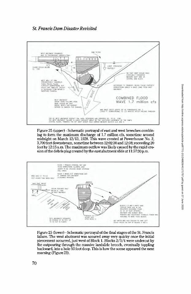
St. Francis Dam Disaster Revisited
Figure 25 (upper) - Schematic portrayal of east and west breeches combin- ing to form the maximum discharge of 1.7 million cfs, sometime around midnight on March 12/13, 1928. This wave crested at Powerhouse No. 2, 3,700 feet downstream, sometime between 12:02:30 and 12:08; receeding 20 feet by 12: 15 a.m. The maximum outflow was likely caused by the rapid ero- sion of the debris plug created by the east abutment slide at 11:57:30 p.m.
Figure 25 (lower) - Schematic portrayal of the final stages of the St. Francis failure. The west abutment was scoured away very quicky once the initial piercement occurred, just west of Block 1. Blocks 2/3/4 were undercut by the outpouring through the massive landslide breech, eventually toppling backward, into a hole 50 feet deep. This is how the scene appeared the next morning (Figure 23) .
70
Dow
nloaded from http://online.ucpress.edu/scq/article-pdf/77/1-2/1/248826/41171757.pdf by guest on 27 June 2020

A Man, A Dam and A Disaster
Figure 26 (upper) - View looking across side canyon just below right abut- ment, near position of Figure 1, just after the failure. Note how the vegeta- tion scour line cannot even be seen, suggesting that the right abutment failed only after the reservoir had dropped at least 60 feet from the crest. Photo from the Huber Collection, University of California Water Resources Center Archives.
Figure 26 (lower) - Detail of failed west abutment, looking downstream, with people circled for scale. Only a portion of the sidecast fill for the construction road was excavated by the outpouring water (arrow), with scrub brush left upon the cut slope side down to elevation 1,775, 60 feet below the reservoir level. Photo by permission of Ventura County Museum of History & Art.
71
Dow
nloaded from http://online.ucpress.edu/scq/article-pdf/77/1-2/1/248826/41171757.pdf by guest on 27 June 2020

St Francis Dam Disaster Revisited
Figure 27 - Close-up view of dam Block 16 [29] , which at 10,000 tons was the largest piece of the dam moved any appreciable distance downstream (as shown in Figures 9 and 10) . This block came from the lower part of the west abutment, adjacent to Block 1, which remained standing. The small holes visible on the upper cold joint were for the form rakers used to hold the forms for the downstream steps when the concrete was poured. Blocks of such immense size can be transported in a dirty fluid or slurry, which great- ly diminishes their effective weight, as shown in Figure 30 upper. Photo by permission of Ventura County Museum of History & Art.
72
Dow
nloaded from http://online.ucpress.edu/scq/article-pdf/77/1-2/1/248826/41171757.pdf by guest on 27 June 2020
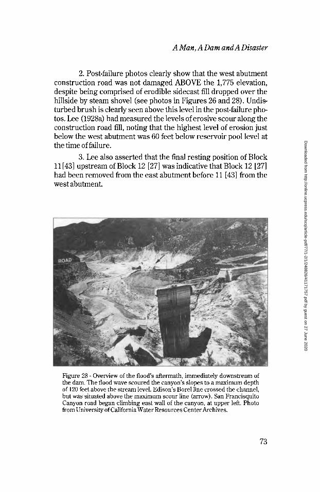
A Man, A Dam and A Disaster
2. Post-failure photos clearly show that the west abutment construction road was not damaged ABOVE the 1,775 elevation, despite being comprised of erodible sidecast fill dropped over the hillside by steam shovel (see photos in Figures 26 and 28). Undis- turbed brush is clearly seen above this level in the post-failure pho- tos. Lee (1928a) had measured the levels of erosive scour along the construction road fill, noting that the highest level of erosion just below the west abutment was 60 feet below reservoir pool level at the time of failure.
3. Lee also asserted that the final resting position of Block 11 [43] upstream of Block 12 [27] was indicative that Block 12 [27] had been removed from the east abutment before 11 [43] from the west abutment.
Figure 28 - Overview of the flood's aftermath, immediately downstream of the dam. The flood wave scoured the canyon's slopes to a maximum depth of 120 feet above the stream level. Edison's Borei line crossed the channel, but was situated above the maximum scour line (arrow). San Francisquito Canyon road began climbing east wall of the canyon, at upper left. Photo from University of California Water Resources Center Archives.
73
Dow
nloaded from http://online.ucpress.edu/scq/article-pdf/77/1-2/1/248826/41171757.pdf by guest on 27 June 2020

St. Francis Dam Disaster Revisited
Figure 29 (upper) - Ground view of Blocks 13, 14 and 11 (left to right), as seen from across the canyon 400 yards downstream of the dam the morning after the failure. Note the enormous bank of schist silt and detritus upon which the blocks were deposited. Photo from University of California Water Resources Center Archives.
Figure 29 (lower) - Portion of panorama of displaced dam blocks, looking downstream from a position about 300 yards downstream of the dam. Block designations are those of the Governor's Board of Inquiry (Figure 9). Photo from Lippincott Collection, University of California Water Resources Cen- ter Archives.
74
Dow
nloaded from http://online.ucpress.edu/scq/article-pdf/77/1-2/1/248826/41171757.pdf by guest on 27 June 2020

A Man, A Dam and A Disaster
4. Much greater volume of the east abutment, in excess of 100,000 cubic yards of material, was swept downstream than within the relatively weak Sespe beds comprising the west abutment, sug- gesting more water, and thereby erosive force was placed upon the east side of the dam site.
5. Blocks [35] and [32], from the so-called "missing sec- tion" between the main dam (Blocks 1/2/3/4) and the east abut- ment, were found furthest downstream after the failure at a far greater distance than any block identified from the west abutment.
6. A large pile of schist from the east abutment was noted beneath Blocks 7 [41] and 5 after the failure, as well as perched upon Blocks 5 and 7, downstream of Block 1, a good 30 feet above creek level. This would suggest that the east abutment landslide carried these pieces down and enveloped them with schist detritus, as shown in Figure 20 upper.
Back-Estimates of Outflow Based on a hydraulic assessment of the flood wave scour depth
and channel cross section, the maximum flow quantity appears to have been approximately 1.7 million cfs, a much higher number than that supposed by the various boards of inquiry, although E.C. Eaton, Chief Engineer of the Los Angeles County Flood Control District, had estimated a peak discharge of something over 1 mil- lion cfs, based on his surveys of the canyonsides and scour marks downstream of the dam (Eaton, 1928) .48 The height of the flood wave at Powerhouse No. 2, 7,300 feet downstream of the dam, was later measured at 110 feet above the floor of the canyon (the maxi- mum water level of the dam being only 179 feet above canyon floor). An engineering check of this estimate is easily accom- plished today by utilizing computerized assessments of unsteady flow with asymmetric cross sections. An outflow hydrograph, or record of the outflow quantity with time was reconstructed for St. Francis Dam (Figure 30, lower) utilizing the established facts. The reconstructed outflow hydrograph suggests that the reservoir must have emptied very quickly through a large breech excavated in the slide debris on the east abutment.
75
Dow
nloaded from http://online.ucpress.edu/scq/article-pdf/77/1-2/1/248826/41171757.pdf by guest on 27 June 2020

St Francis Dam Disaster Revisited
Figure 30 - Preliminary evaluation of flood wave turbidity effects on buoyan- cy of the dam's concrete blocks. Although heavy when dry, tests of the dam's concrete show it to have avoid ratio of around 13 percent. Post-failure photos also suggest that the blocks were saturated, as they wept consider- able moisture for days following the failure. If saturated, and immersed in turbid flood waters, the effective weight of the blocks was reduced by as much as 67 percent.
76
Dow
nloaded from http://online.ucpress.edu/scq/article-pdf/77/1-2/1/248826/41171757.pdf by guest on 27 June 2020

A Man, A Dam and A Disaster
Buoyancy Effects The rapid dissolution of 500,000 to 1 million cubic yards of
weathered mica schist on the east abutment created an outpouring flood wave supercharged with sediment. This large quantity of sed- iment would have a much GREATER relative density than a dis- charge of clean reservoir water. The submerged weight of the dam's concrete blocks would be proportional to the DENSITY of the fluid they displaced. By such a mechanism, normally termed "buoyancy" in channel hydraulics and "effective stress" in geome- chanics, enormous blocks might weigh only a fifth of their dry weight, as demonstrated in the example calculations presented in Figure 30. Back-analyses utilizing conventional "clear water chan- nel hydraulics" would not replicate the eyewitness descriptions of "moving mud" and the simple fact that 500,000 cubic yards of disin- tegrated Pelona Schist quickly vanished from the scene.
Towards the end of the failure sequence, Blocks 2/3/4 fell into the scour hole excavated beneath it by the massive east breech (Figure 23). A hole 60-feet deep was excavated beneath Blocks 2/3/4 according to the state's post-failure surveys (Figure 9). As this east side of the dam's central core toppled over, it separated along near-horizontal cold/pour joints, markedly observed in the pieces remaining on site today. This final sequence is sketched in the lower half of Figure 25, and appears to have occurred when the reservoir had emptied to a level of only 20 to 30 feet above the creek bed (Figure 31).
The Sabotage Theory A number of officials within the Water Works Bureau privately
held that it was their belief the dam had been dynamited as another act of sabotage by the disgruntled inhabitants of Owens Valley. Mulholland had even intimated that this was the case in his testi- mony before the Coronor's Inquest, and Davis (1993) presented the dynamite theory in her recent best-selling work on Mulholland. After the failure of Malpasset arch dam in 1959, similar allegations of sabotage were also put forth (Ministère de L'Agriculture, 1960) .
Outland (1977, p. 49) had related that in late May 1927, shortly following a rash of dynamiting on the aqueduct up north, the Los Angeles County Sheriff had received a phone tip that a "carload of
77
Dow
nloaded from http://online.ucpress.edu/scq/article-pdf/77/1-2/1/248826/41171757.pdf by guest on 27 June 2020

Figure 31 (upper) - Ground view looking upstream on east side of Block 1 at Blocks 5, 7, 2, 3 and 4. The scour hole containing Blocks 2 and 3 must be approaching 60 feet deep in order to have accounted for their buried mass. Huber Collection, University of California Water Resources Center Archives.
Figure 31 (lower) - Ground view booking at upstream face of Block 2 and east edge of Block 1, showing silt scour lines approximately 15 feet above the infilled reservoir floor. These water lines suggest that Blocks 2/3/4 top- pled over late in the flood sequence, when only 20 to 25 feet of water remained in the reservoir. Huber Collection, University of California Water Resources Center Archives.
Dow
nloaded from http://online.ucpress.edu/scq/article-pdf/77/1-2/1/248826/41171757.pdf by guest on 27 June 2020

A Man, A Dam and A Disaster
men were on their way from Inyo County with the intention of dyna- miting St. Francis Dam." Within minutes the Water Works Bureau personnel within the canyon were notified and carloads of deputies sped north to guard the new dam, but no suspects were ever observed.
It was within such framework that the dam failed nine months later. The Water Works Bureau even issued a statement to the press on March 20th suggesting that foul play was involved. At the center of this allegation was the observation of dead fish within the apparently clean water filling large pools created within San Fran- cisquito Canyon during the breakout for a considerable distance downstream of the failed dam. Dead fish were also found on the pile of schist sitting atop Blocks 5 and 7 [41] . Dead fish observed within the reservoir floor were found pointing upstream, supposedly with- out any evidence of "floating."
San Francisco consulting engineer Frank Rieber suspected that the fish were killed by an explosive concussion. With the approval of the Water Bureau, attorney W B. Matthews convened a group to investigate, which appears to have included Professor Edwin Starke of Stanford and engineers F.H. Fowler, Charles Lee,49 and a fellow named Arledge. Starke supervised the recovery of a number of the fish for study by himself and a Mr. Schofield of the California Department of Fish and Game. Starke was of the opinion that the dead fish had not died from lack of oxygen because their gills were closed. He instead suggested that they had died from silt ingestion as the carcasses showed no sign of trauma. This conclu- sion would be in agreement with everything we know about the outbreak flood: that it was a very dirty outflow because of the more than 500,000 cubic yards of schist excavated by the flood wave. Autopsies of the human remains recovered from the Powerhouse No. 2 area also revealed large ingestions of silt. The schistose silt would have settled out of the flood pools long before Rieber arrived.
At the time of the post-failure investigations, the dynamiting theory was considered by the Governor's Board of Inquiry. One member ofthat panel was Dr. E Leslie Ransome, Professor of Eco- nomic Geology at the California Institute of Technology (Cal Tech) in nearby Pasadena. Seismologists Charles Richter and Harry Wood of the Carnegie Institute at Cal Tech had begun recording
79
Dow
nloaded from http://online.ucpress.edu/scq/article-pdf/77/1-2/1/248826/41171757.pdf by guest on 27 June 2020

St Francis Dam Disaster Revisited
rock quarry blasts across southern California in 1923 with an array of seismographs, building up to five different recording stations by early 1928. These seismographs faithfully recorded blasting at rock quarrys in eleven differing localities throughout southern California, from distances of 2.2 to 121 miles (Wood and Richter, 1931). In fact, the Cal Tech seismographs routinely recorded pro- duction blasts at the Monolith Portland Cement quarry (built by Mulholland and Lippincott for the aqueduct) in Tehachapi Pass on seismograph stations located 70 to 100 miles distant. The seismolo- gists soon discovered that these blast shocks closely resembled the records of small earthquakes of nearby origin, with the excep-* tion that they created some phase interference due to their surficial origins (Wood and Richter, 1931) . During this same period seismol- ogists at U.C. Berkeley made similar observations (Byerly and Wil- son, 1935).
As part of his duties investigating the St. Francis failure as a member of the Governor's Board of Inquiry, Ransome asked the Seismological Observatory Director Dr. Harry 0. Wood to check the lab's seismograph for any indication of such energy releases, as would be expected from a dynamite blast, on the evening of March 12-13, 1928. Wood reported that he found absolutely nothing on the seismograph arrays during that time period (Committee Report for the State, 1928). Given the fact that the Pasadena seismograph array routinely detected quarry blasts at Monolith, 70 miles dis- tant, a similar explosion at St. Francis, only 35-1/2 miles away on the same trend, should have been recorded if such explosion actu- ally existed. Armed with this information, Ransome later testified in Ray Rising's wrongful death suit against the city that notions about dynamiting were totally unfounded. Those familiar with the record- ing capabilities of seismographs and accelographs would be com- pelled to agree. Any manner of explosion would had to have been very small not be detected on the Cal Tech or Mount Wilson arrays the evening of the failure.
Post-Failure Notes After an eighteen-year-old man exploring Block 1 with a friend
fell to his death in May 1929 (14 months after the failure), the city chose to have the remaining pieces of the dam demolished (ENR,
80
Dow
nloaded from http://online.ucpress.edu/scq/article-pdf/77/1-2/1/248826/41171757.pdf by guest on 27 June 2020

A Man, A Dam and A Disaster
1929). The imposing mass of Block 1 was blown backward (upstream) by excavating its heel (Figure 32) and loading it with explosives. When it fell it broke apart along near-horizontal pour contacts, much as Blocks 2/3/4 had separated during the failure. What remains is a low mass of concrete rubble, sitting upstream of the dam's original position Cower half of Figure 15).
A new road had to be constructed through San Francisquito Canyon as the east abutment slide and two major slides within the reservoir pool area had forever erased the old route. The new road was built later in 1928 to provide permanent access to Powerhouse No.l, cutting through what had been the west abutment (Figure 17). Most of the original roads built for the Los Angeles aqueduct still lie high above San Francisquito Canyon, including the Bee Canyon Road, Highline Road, Surge Chamber 2 and Haskell Canyon roads utilized by searchers the night of the collapse (although these are all closed to public entry without permission from LADWP). Sometime in the early 1950s the city established Road Camp No. 7 near what was once the upper end of the reser- voir for work furlough crews. Over the years these work crews have constructed a new highway alignment which bypasses the old dam site, its cuts slashing through the former position of the over- flow dike, approximately 1,200 feet northwest of the dam. Soon the memory of California's greatest man-made disaster will simply lie as a footnote in the annals of the state's civil engineering history.
Conclusions
Many lessons can still be gleaned from the St. Francis failure. Foremost of these is the critical importance of soliciting sound engineering geologic input from more than one expert source. A number of prominent geologists viewed the site (John Branner, George Louderback, Leslie Ransome, Allan Sedgewick, L.Z. John- son, Robert T. Hill, CF. Tolman, Hyde Forbes, Tom Clements and Bailey Willis) , but Willis (1928) was the only geologist who recog- nized the geomorphic indicators of ancient landsliding. Somehow, in the failure's aftermath, too much emphasis was placed on the fault which was vividly exposed on the west abutment (Figures 11 and 26 lower).
From all indications it would appear that Mulholland and his
81
Dow
nloaded from http://online.ucpress.edu/scq/article-pdf/77/1-2/1/248826/41171757.pdf by guest on 27 June 2020

St Francis Dam Disaster Revisited
Bureau's engineers did not completely appreciate or understand the concepts of effective stress and uplift, precepts just then begin- ning to gain recognition and acceptance (Floris, 1928; Creager, 1931; Houk, 1932; Weaver, 1932; Henny, 1934; Creager, 1934; and Terzaghi, 1934). If they had, the dam's foundations would have been deeper, a cutoff wall employed, and grout curtain with seep- age relief wells installed beneath the entire structure.
We do know that by 1931 the Department of Water and Power (the BWWS successor agency) was formally apprised of their error when Mulholland Dam underwent independent assessment (dis- cussed later) . The lesson appears to have been learned. By the mid- 19408, DWP field engineer Ralph Proctor, who had helped construct and dissect St. Francis Dam, through the 1920s was pub- lishing internationally on the design and employment of uplift pres- sure relief in earth dams.50
The other weak link in Mulhollanďs design process had been the apparent omission of any outside consultants to review the dam's design, a curious decision considering that he had previous- ly convened a consulting board to review the Los Angeles-Owens Aqueduct plans. During the Coroner's Inquest, Mulholland (1928) stated that he had brought Stanford Professor John Branner to the dam site to view it before construction had commenced, but this had to have been early-on as Branner passed away in March 1922. This assertion is somewhat curious in that prior to March 1922, Mulholland had been pursuing the Big Tujunga Canyon damsite. He may have "brought Branner to the site" back during the days of the aqueduct construction (1911-12) when he made the prelimi- nary assessment of the dam site.
State Review of Dams and Reservoirs The Governor's Board of Inquiry concluded that the owners of
all dams should submit their plans for review by an outside board of consultants; a recommendation almost identical to that made by Idaho's Teton Dam Inquiry Board a half century later. The Coro- ner's Inquest reached a similar verdict, as quoted by Raphael (1988), stating: "A sound policy of public safety and business and engineering judgment demands that the construction and opera- tion of a great dam should never be left to the sole judgment of one
82
Dow
nloaded from http://online.ucpress.edu/scq/article-pdf/77/1-2/1/248826/41171757.pdf by guest on 27 June 2020

A Man, A Dam and A Disaster
Figure 32 - Detail of base of Block 1 during preparations for demolition in August 1929. The upstream heel of Block 1 was excavated, filled with explo- sives and detonated a short time later, forcing the dam's remains to topple backward and split apart along near-horizontal cold (pour) joints. Note the elevations painted in black every five feet running down the upstream face. The gage ladder (Figure 24) had been affixed to the dam just to the left of these numerals. Photo by permission of Ventura County Museum of Histo- ry & Art.
83
Dow
nloaded from http://online.ucpress.edu/scq/article-pdf/77/1-2/1/248826/41171757.pdf by guest on 27 June 2020

St Francis Dam Disaster Revisited
man, no matter how eminent, without... checking by independent experts."
With those conclusions expressed, the State Engineer and President of the Railroad Commission (Hyatt and Whitsell, 1928) proposed legislation mandating state review of all but federally- sponsored dams and reservoirs in California. A sweeping act, it was the first of its kind in the United States, and many other states later followed suit. The legislature enacted legislation to bring about a dam control law the following year. This new law mandated that the owner of proposed dams pay for a review of their projects by a board of eminent civil engineers and geologists retained by the State Engineer. This body subsequently became the Division of Safety of Dams (DSOD), eventually absorbed within the State Department of Water Resources (DWR) , the first such agency cre- ated strictly for dam safety review in the world.
It didn't take long for the sting of the St. Francis memory to be felt. In October 1929, the first board (ENR, 1929) was convened to review another Los Angeles project: Los Angeles County Flood Control's (LAFCD) San Gabriel Dam (also called "the Forks Dam"), then under construction in San Gabriel Canyon, seven miles north of Azusa. The Forks Dam was to have been the world's largest dam up to that time, an arched concrete gravity structure, similar in concept to St. Francis, but 425 feet high and over 2,000 feet across, entaining a reservoir of 240,000 acre feet (more than 6 times the size of St. Francis) . The project became bogged down in September 1929 when excavation of the west abutment began to slide (ENR, 1929). Initially, the county convened their own review board. Then, acting under the aegis of the new law, the state select- ed their own review panel consisting of two engineers and two geol- ogists. Both panels convened independent of each other, but reached identical conclusions: that being that the west abutment, although comprised of dioritic gneiss and mica schist, was, in fact, a paleomegalandslide. Berkeley geology professor George Louder- back, who had served on the Governor's Board of Inquiry on St. Francis eighteen months earlier, was one of those chosen for the state panel that evaluated the San Gabriel Dam. Although he hadn't recognized the paleoslides in San Francisquito Canyon, he was able to in San Gabriel Canyon.51 The world's largest dam project
84
Dow
nloaded from http://online.ucpress.edu/scq/article-pdf/77/1-2/1/248826/41171757.pdf by guest on 27 June 2020

A Man, A Dam and A Disaster
was suddenly stopped and the project cancelled. The dam contrac- tor and chief engineer of the County Flood Control District were subsequently prosecuted on charges of conspiracy, on the grounds that they had known ahead of time that the west abutment was unsatisfactory for an arch dam, and had underbalanced their con- struction bid to gain a high price for foundation excavation, know- ing the main dam structure would never be built.52 They were found guilty and sentenced to prison (ENR, 1929, 1930) .
MULHOLLAND DAM RETROFIT
The next dam the State Engineer convened review of was Mul- holland Dam, which had been operating with a reduced reservoir level since the St. Francis collapse. In January 1930, a board con- sisting of G.A. Elliot J.L. Savage, C.P. Berkey, G.D. Louderback and I.A. Williams was convened to examine the sister dam of St. Fran- cis, located in the Cahuenga hills just above Hollywood. The Bureau of Water Works responded with its own board in March, comprised of L.C. Hill, A.L. Sonderegger and Harvey Van Norman. Although the state's panel did not recommend modification of the structure in their June 1930 report, both panels came to the conclu- sion that due to the dam's lack of uplift relief, the resultant force thrust outside the middle third of the dam, was considered unac- ceptable. Luckily, Bill Mulholland had directed that Hollywood Reservoir be lowered after the St. Francis tragedy, just as a precau- tion. It was one of his last acts as the "Chief," and one which likely saved the dam.
The city would have to build new spillways at a lower elevation to keep the thrust resultant inside the middle third of the structure. In 1931 another panel was formed, this time comprised of B. F. Jakobsen, C.T. Leeds and University of Southern California geolo- gy professor Allen Sedgwick. Jakobsen and Sedgwick issued a majority report stating that the dam had insufficient base width to withstand uplift and earthquake loading, or against basal sliding.
The inherent design deficiencies employed in the Mulholland, and thereby St. Francis Dam, were thus brought to light without substantive fanfare in 1931. The Department of Water and Power made a number of innocuous statements about "alleviating the stress and concern of downstream residents" (who had been flood-
85
Dow
nloaded from http://online.ucpress.edu/scq/article-pdf/77/1-2/1/248826/41171757.pdf by guest on 27 June 2020

St Francis Dam Disaster Revisited
ing the City Council with their fears, given the identical design and layout with St. Francis) . Be that as it may, beginning in 1932 a mas- sive retrofit of Mulholland Dam began, which was to last two years. This work consisted of extending a conduit down Weid Canyon for the spillway and placing over 300,000 cubic yards of earth fill against the downstream face of the dam. It was mute testimony to the deficient design assumptions incorporated into the original structure, but it would appear that DWP had learned their lesson. For the next twenty years DWP took a leading role in developing state-of-the-art engineering procedures, routinely employed peer review panels, and subjected all of their designs to the State Engi- neer for their review.
Requiem for Mulholland
Regardless of the technical gliches of their fast-paced review, the governor's commission appears to have served their political purpose by assigning blame to an individual (Mulholland) in lieu of an organization or profession. From the very outset, Mulholland publicly accepted the blame, telling the Coroner's inquiry that he "only envied those who were killed." His most quoted statement in regards to the failure was his final statement to the Coroner's Inquest, where he told the panel: "Don't blame anyone else, you just fasten it on me. If there was an error in human judgment, I was the human."
Subjected to considerable public scorn in the press, a high pro- file public inquiry at the Coroner's Inquest, Mulholland faced his greatest challenge in a criminal proceeding brought against him by a politically-ambitious Los Angeles County District Attorney named Asa Keyes (who was later found guilty of bribery, conspira- cy and jury tampering and sent to prison; see Davis, 1993) . Mulhol- land, by then seventy-five and suffering from Parkinson's disease, was an easy mark for college professors, who were quick to point out his lack of university pedigree and negligence for not having realized the tendency of Sespe sandstone to slake profusely when dropped into a glass of water.
His professional reputation assassinated, Bill Mulholland re- signed as Chief Engineer and General Manager of the Bureau of Water Works and Supply after the inquiries and trials in November
86
Dow
nloaded from http://online.ucpress.edu/scq/article-pdf/77/1-2/1/248826/41171757.pdf by guest on 27 June 2020

A Man, A Dam and A Disaster
1929. Though broken in spirit, the monuments of his life's accom- plishments have continued to serve as the lifeblood of millions of Angelinos: he had created the model public water agency of the semi-arid west; he created what became the largest public utility agency (the Bureau of Power and Light) in the United States; and his dream of a Colorado River Aqueduct was in the process of achieving fruition when he quietly passed away on July 22, 1935. Few engineers have graced the earth who gave so much to society.
In the modern era, chocked full of environmental awareness and the benefit of hindsight afforded historians, he has been criti- cized for not having acquired Eaton's ranchlands earlier than 1932. These critics point out that if he had built the Long Valley Reservoir (Lake Crowley) before the 1922-25 drought, there would not have been a water crisis in the early 1920s. Others cite the $27 million the city had spent acquiring Owens Valley properties by 1925, which seemed like a whole lot of money in comparison to the paltry one million Fred Eaton held out for in vain.
But, we should remember that the land barons of Los Angeles (Davis, 1993) were attempting to construct their water infrastruc- ture AHEAD of their burgeoning population base. The engineering economics of the first Los Angeles aqueduct were extremely tenu- ous, by anyone's standards: when Mulholland's $23 million con- struction bond was approved by the voters in 1906, Los Angeles had a population less than 240,000 people, barely enough to fund such an undertaking given the average per capita salaries of that era Gess than $900 per year) . Had ANYTHING gone wrong on the Owens aqueduct, similar to the problems experienced by San Fran- cisco in constructing their Hetch Hetchy line, Los Angeles would have been forced into receivership. That Mulholland pulled it all off, on time and on budget without so much as a hair of prior experi- ence, would seem almost providential.
Mulholland has also been scolded from the vantage point of not having a crystal ball to see the explosive and unprecedented growth of Los Angeles. In large part this migration was brought about by an incredible change in American lifestyle in the years immediately following the First World War: suddenly there were affordable cars, which meant people could drive themselves to work; gasoline was cheap; railroads cut prices to compete with
87
Dow
nloaded from http://online.ucpress.edu/scq/article-pdf/77/1-2/1/248826/41171757.pdf by guest on 27 June 2020

St Francis Dam Disaster Revisited
cars; a system of public highways was suddenly advanced across the entire state; silent movies and radio were broadcasting alluring advertisements to an entire generation; and magazines with tinted photos of a Garden-of-Eden atmosphere lured people to Los Ange- les by the thousands.
The men who had brought the water and made it all possible, people like Mulholland, Eaton, Freeman and Grunsky, were all born in 1855; theirs was another era, transitioning into a new sort of world that would have been hard to imagine in 1905 when the aque- duct planning was carried out.
I began the journey of examining Bill Mulholland close to twenty years ago with a jaundiced eye, prejudiced by nearly a half century of unmitigated slander. Mulholland was the fall guy, the St. Francis fail- ure was his fault, he had even said so. After considerable study, I am of the opinion that we should be so lucky as to have any men with just half his character, integrity, imagination and leadership today. Big Bill Mulholland was the kind of rugged individualist that made great things happen, but his style of standing on principle would never be seen as "politically correct" in the style of today's committee-sitting, bean-counting, lawyer-consulting, image-conscious compromisers. Mulholland would sooner "give birth to a porcupine backwards" than to have to work inside air conditioned buildings sitting in padded chairs with people of compromising principle.
We could learn a great deal about character from studying his life, for despite any shortcomings he may have harbored in his later years, his integrity remained intact despite what were probably the most stressful challenges ever faced by an American civil engineer in the months following the St. Francis tragedy. Despite a gruff exterior, Mulholland appears to have been a caring individual. His tears and the carefully chosen words while under attack on the stand reveal a genuine humbleness and remorse. It would seem unjust to judge the men of one era by the standards of another. I think history will be kinder to Bill Mulholland than his contempo- raries.
88
Dow
nloaded from http://online.ucpress.edu/scq/article-pdf/77/1-2/1/248826/41171757.pdf by guest on 27 June 2020

A Man, A Dam and A Disaster
Epilogue
Looking back, it's particularly sad that the engineering profes- sion didn't do more to unravel the causes of the failure. With the exception of Grunsky, Willis, Gillette and Lee, the published dis- cussions focused on the fault, Sespe beds' propensity to slake under submersion, and the Sespe's low shear strength, which was about one fourth that of the dam's concrete. The larger culprits appear to have been a proper appreciation of uplift theory and the incorporation of solid engineering geologic input. A similar failure mechanism befell Malpasset Dam thirty-two years later, and it was only after YEARS of studying that failure that the importance of complex rock mechanics analyses were demonstrated (Londe, 1968, 1969, 1970). Had people kept working on St. Francis, the real complexity of the failure might have been discovered.
Around the 50th anniversary of the failure, in the spring of 1978, Charles Outland asserted that much about the St. Francis tragedy had been conveniently swept under the table to keep from impairing the titanic battle then ensuing in Congress over the ratifi- cation of the Colorado River Compact and the Boulder Canyon Pro- ject, then being hotly contested by Arizona (Nadeau, 1993). Outland's assertion appears well founded. The last thing the Angelinos needed at that time was the failure of a curved concrete gravity arch dam, the precise manner of structure then being pos- tulated for Boulder Canyon. Mulholland's magnanimous public acceptance of the blame served to end the inquiries, and the matter quietly passed. Within four years BWWS built a replacement struc- ture in Bouquet Canyon. The Bouquet Canyon dams were the first mechanically compacted earth dams in the United States actually tested for compaction during construction, and led indirectly to the birth of the mass grading and excavation industry that shaped southern California development in the years following the Second World War.53
It is of more than passing interest to note that much of what we can discern from the St. Francis failure didn't come from civil engi- neers or geologists, but through the efforts of a single historian. The late Charles Outland, a life-long Ventura County resident and native of Santa Paula, spent the better part of his mature years researching the failure. As a high school senior, Outland watched
89
Dow
nloaded from http://online.ucpress.edu/scq/article-pdf/77/1-2/1/248826/41171757.pdf by guest on 27 June 2020

St. Francis Dam Disaster Revisited
the flood decimate his hometown in the early morning hours of March 13, 1928. It was a sight he was never to forget. For thirty years he researched the St. Francis failure. This effort culminating with the publication of his first book, Man-Made Disaster, which first appeared in 1963 and was expanded upon in 1977. It continues to be the only definitive work ever published on the construction and failure of the St. Francis Dam.
In researching the failure from an engineering perspective over the past twenty years, one gets the distinct impression that the Los Angeles Department of Water and Power would just as soon bury the memory of the failure, though they have always been forthcoming with the author in responding to a myriad of requests. For engineering geologists, St. Francis will forever exist as a warn- ing beacon to those who do not heed the importance of geologic input. A structure is only as strong as its foundation. No student of geology in southern California has completed his or her college curriculum without a visit to the imposing waste and heartfelt tragedy of the St. Francis site. Might we never forget it.
90
Dow
nloaded from http://online.ucpress.edu/scq/article-pdf/77/1-2/1/248826/41171757.pdf by guest on 27 June 2020

A Man, A Dam and A Disaster
NOTES
Acknowledgments. The author would like to express his most sincere gratitude to Dr. Doyce B. Nunis, Jr., Professor Emeritus of History, University of Southern California, who formulated the idea for this article. It is a difficult assignment for an engineer to write an his- torical essay for lay audiences. His patient encouragement over these past two and one-half years and experienced editorship have made this contribution possible.
The author also wishes to thank past and present colleagues in the Department of Civil Engineering at the University of California, Berkeley. Interest in making a modern-era reassessment was fostered by the late Jerome M. Raphael (1911-89) , Professor Emeritus of Structural Engineering at Cal, a recognized expert on concrete gravity dams for many years. The many anecdotes contained herein about the various personalities emanated from my many conversations with Professor Raphael between 197¿81. 1 was fortunate to inherit his files on the dam's failure which included many original materials from state and federal agen- cies.
Fellow geotechnical engineers Robert B. Rogers and David L. McMahon provided many constructive comments on technical aspects involved in unraveling the failure. Professor Lawrence J. Herber of California State Polytechnic University, Pomona, provided the plane table survey and geologic map of the dam site made in 1980. Dr. Fred Chin prepared the com- puterized preliminary keyblock analyses and tested samples of the foundation materials in the Rogers/Pacific lab. Dr. Max Ma performed the discontinuous deformation analyses of the sloping abutment sections that revealed much about the foundation's sensitivity to the effects of uplift.
Historians and librarians provided the bulk of historical documentation critical to sorting out fact from conjecture. These included Charles Johnson, Librarian of the Ventura County History Museum, which houses the Charles Outland Collection; Gerald Geiffer, Susan Greer and Linda Vida-Sunnen of the University of California Water Resources Center Archives in Berkeley, where the personal files of J.B. Lippincott and Charles H. Lee are archived; and Dr. Paul Soifer, the archivist of the Los Angeles Department of Water and Power, who provided access to that agency's voluminous files. Most of all I would like to per- sonally thank Frank Stock, Principal Drafting Technician of the Los Angeles Department of Water and Power, who doggedly pursued finding copies of the original St. Francis design, as- built plans, photographs and related documentation as exists in DWP files in regards to St. Francis and Mulholland dams.
Lastly, Margaret Leslie Davis, author of Rivers in the Desert, passed along innumerable hard-to-find references, contacts, phone numbers and a sympathetic ear whenever I hit dead- ends. She deserves much of the credit for pointing me to what non-technical documents exist on Mulholland's life and the early activities of the Bureau of Water Works and Supply.
4n water resources engineering, the terms "right" and "left" abutment refer to the respective channel banks when viewed facing downstream.
2Mulholland originally rose through the ranks within the privately-held Los Angeles City Water Company, succeeding Fred Eaton as the Chief Engineer in 1886. In 1898 the franchise of the company expired, and the firm's holdings were acquired by the city in 1902, with Mul- holland retained as Chief Engineer and General Manager. The new water agency would be a bureau within the Los Angeles Department of Public Services, simply titled the Bureau of Waterworks and Supply (BWWS) .
During construction of the original Los Angeles-Owens River Aqueduct (1906-13), the Waterworks Bureau built two modest-sized hydroelectric plants to generate power from small tributaries emanating from the east Sierra escarpment. In 1911 Los Angeles voters approved a charter amendment that established a municipal power system, and the Bureau of Power and Light (BPL) of the Department of Public Service was bora, under the direction of graduate electrical engineer E.F. Scattergood, who had originally served as power chief on the aqueduct. It wasn't until 1916 that the first municipal power was actually delivered.
91
Dow
nloaded from http://online.ucpress.edu/scq/article-pdf/77/1-2/1/248826/41171757.pdf by guest on 27 June 2020

St Francis Dam Disaster Revisited
Mulhollanďs decision to enter into the hydroelectric power business appears to have been fostered in part by attempts of the electric companies to lock him out of the public utilities market (see Nadeau, 1993, p. 30) . Los Angeles gradually absorbed the infrastructure of the three private utilities supplying the city, eventually becoming the largest municipal electric utility in the nation. Hydroelectric generation stations were built along the aqueduct, includ- ing San Francisquito No. 1 in 1917 and No. 2 in 1920.
The two bureaus were combined on January 13, 1931 to become their own separate department within the city, called the Los Angeles Department of Water and Power, or "DWP," the acronym commonly associate with the agency today.
3When asked in Court to describe his qualifications as an expert on water engineering, Mulholland had responded: "Well, I went to school in Ireland when I was a boy, learned the three R's, and the Ten Commandments - or most of them - made a pilgrimage to the Blar- ney Stone, received my father's blessing, and here I am." But, it was not uncommon for engi- neers in the late nineteenth century to be self-educated, learning their craft through apprenticeship and individual study. None of the principal players involved in the design and construction of St. Francis, Mulholland, Harvey Van Norman, W. W. Hurlbut, E. A. Bayley or Ralph R. Proctor, ever completed university degrees in engineering. In the era in which Mul- holland and Fred Eaton educated themselves (1890), the International Correspondence Schools (I.C.S.) produced a six-volume set on civil engineering that is still regarded as a benchmark reference on the state-of-the-art at the time. That they created a water infrastruc- ture for several million people would seem sufficient testimony to their abilities.
It was not until 1944 that the Los Angeles Department of Water and Power (DWP) was headed by a graduate engineer, when Samuel Brooks Morris (Stanford Class of 1911) left his post as Dean of Stanford's engineering school.
4"Memoir of William Gomer Davies (1877-1915)" by D.W. Ross, in Transactions of the American Society of 'Civil Engineers ; v. 80, pp. 1474-75.
5Few substantial watersheds with perennial streams exist in southern California. The largest Coast Range watersheds outside of the Los Angeles River (which included BigTujun- ga and Arroyo Seco) were the San Gabriel, Santa Ana, Santa Clara and Santa Ynez. But, waters from the San Gabriel, Santa Ana and Santa Clara rivers had been entirely developed for some time (Hall, 1888) and legally secured by co-operative agricultural interests before the turn-of-the-Century (Harding, 1960) . The Wright Act of 1884 set forth the legal tenets for localized irrigation districts, the formulation of which provided virtual legal security to source watershed resources.
6The allegation about Eaton having owned property in the Owens Valley area beginning in the late 1880s emanates from an article on the aqueduct's construction in the July 1910 issue oí National Geographic by Burt Heinly (1910). Burt Heinly was Mulhollanďs personal secretary. If Eaton did own another property prior to his acquisition of the Long Valley Ranch in 1905, he may have lost this property in the process of his divorce a short time before. Eaton remarried in June 1906 and moved with his young bride to the Long Valley Ranch (Davis, 1993, p. 20).
Son of a California '49er, Frederick Eaton was born one day after William Mulholland in an adobe home just west of the Plaza of the Pueblo of Los Angeles in 1855. He went to work for the privately owned Los Angeles Water Works at the age of fifteen, rising to the position of General Superintendent through self education and study. After appointment as City Engi- neer for Los Angeles in 1886, he designed and built the city's first sewage system. He visited the Owens Valley in 1892 to evaluate its potential as a water source for Los Angeles, and through the use of barometers determined that a gravity-flow aqueduct was feasible. He began to lobby Mulholland on behalf of an Owens aqueduct in 1902, when Mulholland became a public servant. When the Reclamation Service began their study of the Owens River watershed in 1903, the lands within the watershed were withdrawn by the Department of the Interior. Eaton obtained options to purchase the substantial land holdings of the Rick- ey Cattle Ranch in the northern half of the Owens Valley, which included the Long Valley area now occupied by Lake Crowley. He was the central figure in organizing negotiations between the city and the Reclamation Service that eventually led to the city's acquisition of
92
Dow
nloaded from http://online.ucpress.edu/scq/article-pdf/77/1-2/1/248826/41171757.pdf by guest on 27 June 2020

A Man, A Dam and A Disaster
Owens water via an act of Congress and presidential approval. Eaton then sold his options on the Rickey Ranch property south of Long Valley to the city for cost, but held onto that portion above the Owens Gorge which showed promise as the most favorable dam site. Eaton held out for something more than a million dollars for another twenty-eight years, but the Long Valley property was eventually acquired by the city out of receivership in December 1932 for $640,000. Reconciling his differences with Mulholland shortly before his death, Eaton died in March 1934, followed by Mulholland a year later.
7Formed by the Federal Reclamation Act of 1902, the Reclamation Service was subse- quently upgraded to a Bureau in 1923, taking on the acronym USBR, for U.S. Bureau of Reclamation. The Reclamation Service began studies of all of possible major irrigation pro- jects in the west in 1903. Reclamation engineer J.C. Clausen was sent into the area to perform the necessary feasibility studies during 1903-04. At the time the Reclamation Service's Chief of Southwest Operations was J.B. Lippincott, who had served on the Board of Adjusters when the city purchased the Los Angeles Water Company in 1902. An established water resources engineer, Lippincott and Eaton were well acquainted with one another. When Lip- pincott went to the Sierras to consult with Clausen in August 1904, Eaton was invited by Lip- pincott to come along (Nadeau, 1993; Lippincott, et al, 1935). We must assume that Eaton's participation in this trip was strategically orchestrated by Lippincott, who likely knew of Eaton's interest in the Owens water. By May 1906, when the city's designs on the Owens water became a public battle, Lippincott was forced to resign his position with the Reclama- tion Service, whereupon he accepted Mulholland's offer to become Assistant Chief Engineer of BWWS, in charge of the aqueduct's construction.
Joseph B. Lippincott (1864-1942) was an 1887 graduate in civil engineering from the Uni- versity of Kansas. He worked for the Santa Fe Railroad and the U.S. Geological Survey before entering water resources development in southern California in 1893, working in the Santa Ana River basin, and later for the U.S. Geological Survey and the Federal Reclamation Ser- vice. He left Mulholland's employ when the aqueduct was completed in 1913 and established a thriving consulting business in water resources development in California. He was the only contemporary of Mulholland who publicly defended his career after his fall from grace, authoring a series of articles on Mulholland for Civil Engineering magazine in 1940. He died in 1942 and his life's papers and photographs have been preserved in the Water Resources Archives at the University of California, Berkeley.
8This assessment was based upon simple knowledge of the topographic obstacles which had to be overcome over any of the candidate routes to Los Angeles. A Kern River source required crossing either Tehachapi or Tejon Passes, with crest elevations over 4,000 feet. The power requirements for pumps of that era would have negated any further considera- tion. The route to the Colorado River was much longer, and would also require lifting the water close to 2,000 feet. The Owens River route required the least topographic obstacles and could flow via gravity, which would far outshadow operating costs for any of the other alternatives. From an engineering, maintainence and cost-utilization point-of-view, it was the only viable alternative.
4he original Croton Aqueduct between New York City and the Croton Dam (on the Cro- ton River) , was 45 miles long, had a capacity of 79 million gallons per day (gpd) , and was com- pleted in 1842. New York boasted a population of 360,000 people in 1842, more than any other American city.
The new Croton Aqueduct was capable of discharging 340 million gpd, which easily han- dled New York's average draft of 200 million gpd in 1892. But, swelling with immigrants and industry, by 1905 New York was forced to embark on an even more ambitious water develop- ment project, the Catskill Aqueduct. The Catskill is capable of delivering something more than 600 million gpd through a 69-mile route, which included 55 miles of tunnel or cut- and cover section to New York City (work continued on this project up until 1937, though water first reached the city in 1917) .
10Their estimates of future water requirements were hailed as poppycock in much of the press, but turned out to be below the emigration boom that actually occurred over the suc- ceeding half century.
93
Dow
nloaded from http://online.ucpress.edu/scq/article-pdf/77/1-2/1/248826/41171757.pdf by guest on 27 June 2020

St. Francis Dam Disaster Revisited
nThe use of the siphon wasn't actually new, Roman engineers had employed the concept to cross the Rhone River at Aries by means of pipes laid in the river bed (DeCamp, 1990) .
12A giant of the eastern establishment in civil engineering, Freeman's selection to the panel was a real coup for the Board of Public Service Commissioners. John R. Freeman (1855-1932) graduated from the Massachusetts Institute of Technology in 1876, and later received honorary doctorates from Brown University (1904), Tufts College (1905), Pennsyl- vania (1927), Yale (1931), Sachiche Technischen Hochschule in Dresden and Ehrenbürger der Technischen Hochschule in Karlschule. Upon graduation from MIT he was employed in waterworks engineering in New England. In the 1880s he was the first engineer to retrofit factories with fire prevention systems and pioneered the design of modern fire fighting water supply systems. He was a major consultant on the new Croton Aqueduct for the City of New York in the 1890s. He had come to San Francisco shortly after the great fire in May 1906 to study the casualty loss aspects of that city's earthquake-induced fire damage for a consor- tium of insurance companies. Seeing the enormous engineering challenges about him, he decided to remain in California. Between 1910-12 he authored an extensive study on water resources in central California for the City of San Francisco which recommended their acqui- sition of water rights for the Tuolumne River and construction of the Hetch Hetchy water project. Freeman spent the balance of his life fathering the modern science of earthquake engineering, while serving as a member of the Panama Canal Commission (during construc- tion) and president of the American Society of Civil Engineers in 1922. Internationally respected within the engineering community, his stamp of approval on the aqueduct design and retention as an advisor during construction brought the project into both national and international prominence (Heinly, 1910).
13As far as the author is aware, this represented the first time external review panels were used on a civil engineering project in California. Panels composed of private consultants of eminent standing are now commonplace within the engineering profession whenever a structure whose failure could endanger public safety is contemplated. The employment of external boards of consultants to review major engineering structures was one of the funda- mental recommendations that came out of the St. Francis Dam disaster.
14This facility produced up to 1,000 barrels per day of Portland cement by calcining natur- al limestone. The grey-colored powder, when mixed with sand, gravel and water, forms Port- land cement concrete. Lippincott (1913) "stretched" this precious cement by blending it 50/50 with soft volcanic tuff (ash) mined near Haiwee. The tuff was a sort of natural cement, took longer to harden, but made a stronger concrete. This novel introduction of so-called "blended cement" saved the city several million dollars and earned Lippincott the Croes Medal of the American Society of Civil Engineers in 1914. The facility has since remained in commercial operation.
15The original cascades seen in the dramatic opening ceremonies photographs were removed in 1965 in order to bunch DWP's existing pipelines with the second Los Angeles aqueduct, under construction between 1965-69. This relocation effort was made necessary to accommodate all the various water lines into single bridge crossings of the Antelope Valley Freeway (State Route 14), then also under construction. The baffle block chute and channel seen today on the hillside was completed in 1968. The circular steel penstock paralleling the cascades carries aqueduct water to the Foothill Powerplant when that facility is operating. As a consequence, water is rarely seen flowing down the new cascades chute.
16At the height of the drought in 1923-24 a Board of Consulting Engineers was convened to consider the city's options. The members were J.B. Lippincott, Louis C. Hill and AX. Son- dregger. This group concluded that if Los Angeles were to capture and convey the entire runoff from the Owens and Mono Basin watersheds, utilize existing groundwater resources, and that if the city continued to grow at its then-present rate, the Angelinos would run out of water by 1933 (The Intake, October 1924). The Board recommended that BWWS pursue a Colorado River aqueduct.
On October 23, 1923, Mulholland personally launched the first surveys of a new and larg- er aqueduct, this one stretching to the Colorado River on the California-Arizona border (Schwartz, 1991; Nadeau, 1993) . The route eventually chosen would be that basically blazed
94
Dow
nloaded from http://online.ucpress.edu/scq/article-pdf/77/1-2/1/248826/41171757.pdf by guest on 27 June 2020

A Man, A Dam and A Disaster
that winter by Mulholland. Though similar in length to the Owens aqueduct at 242 miles, it had a larger cross section, required lifting the water 1,600 feet at the outset, and over 97 miles of bored tunnels and 158 miles of distribution lines. It was a mega-project, too large in fact for only one city, no matter how bustling, to handle alone. The "Chiefs" Colorado Aqueduct would be completed six years after Mulholland's death by the Metropolitan Water District, yet another water agency created specifically to meet this new challenge.
17Acre-feet is the common volumetric measure used in water resources. It equates to the volume of water one foot deep spread over one acre of area. There are 43,560 square feet in an acre, and 7.48 gallons per cubic foot. This means that one acre foot of water equals approx- imately 326,000 gallons. Haiwee's maximum capacity of 43,000 acre-feet would be about 1.43 billion gallons.
18See note 16, ante. 19These crude percolation tests "passed" in that they retained the water poured into
them. It was only after the dam failed that geologists would recognize that the Sespe beds had a profound tendency to "slake," or explosively disintegrate, when immersed in water. The reason Mulholland's holes "held" water was that the sides of the test holes absorbed the water and caved inward, thereby displacing absorbed water volume and appearing to "retain" water within the holes (which was probably a mixture of very muddy water at best after some period of time). Slaking became recognized in the engineering literature appur- tent to the construction of tunnels along the Colorado River aqueduct in the late 1930s.
20John С Branner was head of the Department of Geology at Stanford University up until the time of his death in March 1922. He had taught at Stanford since the late 1890s and was widely known for his efforts and accomplishments in the field of applied geology. Mulhol- land told the Coroner's Inquiry "that you couldn't do much better than Branner [for a geolo- gist] at the time [1922]." Most who've studied that era would agree with this assertion. No record has been recovered documenting this consultation.
21Hydraulic mining had essentially been outlawed in California in 1884 following the State's Supreme Court's decision in Woodruff vs. North Bloomfield. The decision came after 20 plus years of court actions brought about by disgruntled farmers whose properties had been buried in mine "slickens," as the fine silt was called. These slickens began to inundate the Yuba, Feather, Bear, American and Sacramento River flood plains during the record floods of 1862, and continued well into the twentieth century, clogging the bedrock channel of the Yuba River with as much as 85 feet of silt fill. By 1983 the Yuba River had finally cut back down to its pre-1862 grade, but the river's flood plains retain upwards of 25+ feet of the post-1862 silt.
22During the February 1971 San Fernando earthquake the Lower San Fernando Dam (built in stages, between 1911 and 1940) experienced a near-catastrophic failure due to par- tial liquefaction of the upstream shell. Post-quake engineering investigations revealed the terrible fragility of hydraulic fill embankments to cyclic seismic loading. The State subse- quently required retrofitting of all hydraulic fill embankments. The replacement structure for the Van Norman Reser oin vas christened the Los Angeles Reservoir and was placed in operation in 1977. One of *b-- b' t hydraulic fill dams upon which Mulholland consulted awaiting retrofit is the massi re Catun Dam, kingpin structure of the Panama Canal. It is cur- rently under review.
23 Although Mulholland publicly accepted the entire blame for the dam's design, con- struction and failure, he was not the actual designer. During the Coroner's Inquest on March 27, 1928, BWWS Office Engineer W. W. Hurlbut testified that the plans and specifications for both Mulholland and St. Francis dams had been prepared by fellow BWWS engineer Edgar A Bayley under Hurlbut's supervision (Mulholland Dam had originally been called Weid Canyon Dam and was completed in March 1925). Hurlbut was the person directly in charge of the design, while Mulholland was the responsible head of the agency. In September 1923, Mulholland left for the Colorado River to begin directing preliminary surveys for a Colorado River aqueduct, an activity in which he was almost continuously engaged, on and off, for the remainder of his career.
24Carl Ewald Grunsky (1855-1934) was the most lauded civil engineer on the California
95
Dow
nloaded from http://online.ucpress.edu/scq/article-pdf/77/1-2/1/248826/41171757.pdf by guest on 27 June 2020

St. Francis Dam Disaster Revisited
scene between the turn-of-the-century and his death in 1935. He and Mulholland served as consultants to the newly-formed East Bay Municipal Utility District in Oakland throughout the 1920s. Born of pioneer parents near Stockton the same year as Eaton, Mulholland and Freeman, Grunsky worked his way through the civil engineering curriculum at Stuttgart Polytechnikum in Württemberg, Germany, graduating in 1876. He later received honorary doctorates from Stuttgart (1910) and Rensselaer Polytechnic Institute (1924). Young Grun- sky returned to California and was employed in the State Engineer's office between 1878-88, at which time he became one of California's first true consulting engineers, specializing in irrigation and sewerage problems. He designed several projects of note almost singlehand- edly, including the Sacramento River flood control system and its series of high-flow bypass- es (still in use today) and San Francisco's sewerage system and ocean outfall (also still in use) . He served as San Francisco's first City Engineer between 1900 to 1904, and in 1905 was the only engineer west of the eastern establishment to be named by President Theodore Roosevelt to the original Isthmian Canal Commission overseeing the technical aspects of the Panama Canal project. From 1908 until his death he maintained a private consulting practice in San Francisco. In 1910 he received the Norman Medal of the American Society of Civil Engineers, the highest honor bestowed for technical achievement by that august society. He subsequently served as president of the California Academy of Sciences (1912), American Association for the Advancement of Science, and the American Society of Civil Engineers (1924) . Though the same age as Mulholland, Grunsky was the big engineering wheel of San Francisco that Mulholland was in Los Angeles. But, Grunsky also embodied much of what Mulholland was not: a university graduate, elected industry spokesman/leader, and a learned scholar of international renown, educated in the classic European tradition.
According to Outland (1963, p.33) , A.C. Hardison, a local rancher and one of the founders of the Santa Clara River Protective Association, told Outland that he had been the person to encourage hiring a "name engineering firm" to independently investigate the hydrologie implications of what was being contemplated by the BWWS in San Francisquito Canyon. He could not have done much better. At the time Grunsky had just stepped down as president of the American Society of Civil Engineers.
25Harza published his first large article on uplift in 1935 in the Transactions of ASCE. His subsequent effort, which included considerable published data, was published in 1949 and was subsequently cited for the Croes Medal, one of the highest honors bestowed by the American Society of Civil Engineers.
26A native of San Jacinto in Riverside County, Hyatt (1888-1954) was only thirty-eight when called upon by the governor to arbitrate this dispute between two mega-personalities of the civil engineering profession, both of whom were thirty-three years his senior. Afield test offered the only politically-acceptable method to test the efficacy of what each man alleged. A Stanford graduate who spent his entire thirty-five year career in state service, Hyatt was then serving as Chief of the Division of Water Rights within the State Department of Public Works. His artful handling of the San Francisquito dispute was not unnoticed, and the following year (1927) Governor Young appointed him to the office of State Engineer (Hyatt's predecessor in the position, W.F. McClure, had been critical of Los Angeles in state investigations of the Owens Valley water wars) .
It was in this high visibility role that Hyatt served during the St. Francis disaster and its aftermath. Hyatt then formulated the idea of an independent panel or commission of experts to review all but federally-built dams and reservoirs in California, which eventually became the Division of Safety of Dams (DSOD) ofthe State Department of Water Resources (DWR). In 1965 the underground hydroelectric power plant then under construction at Oroville Dam was named in honor of Hyatt.
27In this incident Mulholland was alleging that the alluvial gravels within lower San Fran- cisquito Canyon were not being hydraulically recharged by the creek's flow. This allegation by someone with Mulholland's experience seems incredulous. For years Mulholland had recognized that runoff from the upper Los Angeles, Pacoima, and Big and Little Tujunga creeks sank into the gravels of their channel beds and flowed underground to the south side of the San Fernando Valley, where they are forced to the surface at the base of the Santa
96
Dow
nloaded from http://online.ucpress.edu/scq/article-pdf/77/1-2/1/248826/41171757.pdf by guest on 27 June 2020

A Man, A Dam and A Disaster
Monica Mountains. Mulholland had even gone so far as to address the basis for the city's legal right to this groundwater (The Intake, December 1924). Early in his career it was com- mon knowledge that virtually all of the streams emanating from the San Gabriel Mountains petered-out before reaching the Pacific due to significant channel infiltration losses in the coastal alluvium (Hall, 1888).
28Harvey A. Van Norman (1878-1954) was born in Texas, but reared in the Los Angeles school system. Like Mulholland, he was completely self-educated through correspondence courses, intensive home study and tutoring from engineer friends (Morris, Leeds and Grant, 1954). Young Van Norman worked for Fred Eaton at the Los Angeles Railroad Company, Pacific Electric, and Los Angeles Gas and Electric Company before Mulholland hired him to build the hydroelectric power plants along the Owens aqueduct in 1907. He subsequently served as engineer-in-charge of the Lone Pine, Owens Valley and Mojave divisions of the aqueduct during construction. Mulholland developed a deep trust and abiding affection for "Van," as he was called (Davis, 1993), and he supervised the maintenance and operation of the aqueduct between 1913-23. In 1923 he was given a leave of absence from BWWS to work on the Los Angeles sewer outfall, then serve as interim City Engineer (August 1924 to Octo- ber 1925), whereupon he was recalled to BWWS as Assistant Chief Engineer of the Water Bureau. When Mulholland officially resigned his position in November 1929, Van Norman succeeded him as Chief Engineer and General Manager of the Bureau of Water Works and Supply. Van Norman retained this same title when the power bureau was absorbed into one coherent Department of Water and Power in January 1931. Van sat in the hot seat through five years of post-St. Francis assessments of the city's dams and reservoirs by several inde- pendent boards, committees and consultants. The balance of his career as Chief Engineer then spanned even larger water supply projects than those of his mentor, and included the final surveys of the Colorado River Aqueduct (subsequently built by the Metropolitan Water District between 1933-41) , the construction of the Bouquet Canyon Reservoir and pipeline as the replacement for St. Francis between 1931-35, and the Mono Basin Project between 1935- 41, which extended the Owens aqueduct another 108 miles northward. Van Norman retired on September 30, 1944. After his death in January 1954, DWP renamed the upper and lower San Fernando Reservoirs after him.
29This observation confirms that hydrostatic uplift had developed within the mica schist comprising the steeply sloping left abutment. The abutments had not been afforded any manner of seepage relief during construction. The photograph reproduced in Figure 2 with the reservoir approximately 18 feet below spillway (possibly the previous year) shows seep- age along the entire downstream side of the left abutment.
30Harnischfeger had worked for DWP as an aqueduct guard prior to accepting the damkeeper's position in 1924. He lived in a cottage about 1/4 mile downstream of the dam. In the process of having his divorce decree finalized, his 6-year old son was living with him and a woman named Leona Johnson. Johnson's clothed body was found wedged between dis- placed blocks of the dam, upstream of the dam (Outland, 1977, pp. 73-75) . This discovery suggests that Harnischfeger and Johnson were clothed and awake somewhere between their cottage and the dam when caught in the outbreak. There is no other plausible explana- tion for her body being found so far upstream of the caretaker's cottage.
31The mystery witness was referred to as "a Powerhouse No. 1 family," presumably dri- ving together. A review of the Coroner's Inquest reveals that Powerhouse No. 1 operator Henry (Ray) Silvey also travelled the road that evening, arriving at Powerhouse No. 1 around 9:25 p.m.. Silvey was likely Outland's "mystery witness" who refused to be identified in regards to this particular observation. He was on an LADWP pension at the time of Outland's 1962 interview.
32Prior to the dam's collapse, San Francisquito Canyon Road hugged the southeast canyon wall and passed the dam's east abutment approximately 10 feet above the dam's crest. Only a walking trail led onto the dam crest on this side (Figure 2) . The only way of dri- ving directly onto the dam was by driving along the service road to the damkeeper's resi- dence, then climbing the 18 percent grade of the dirt road cut into the walls of the tributary canyon below the wing dike right (Figure 17) on the west abutment (construction was under-
97
Dow
nloaded from http://online.ucpress.edu/scq/article-pdf/77/1-2/1/248826/41171757.pdf by guest on 27 June 2020

St. Francis Dam Disaster Revisited
way to grade a new access road with less steep grades at the time of the failure, appreciated in Figure 11).
For a tension scarp 12 inches high to have developed within the road, cut into the mica schist, would have meant the east abutment was beginning to separate as a large bedrock landslide, as the road was built entirely in cut at this location. Outland (1963,1977) related that these tension cracks along the road had been noted as early as Saturday, March 10th (two full days prior to the failure) . It is important to realize that Mulholland and Van Norman WOULD NOT have driven along this portion of San Francisquito Canyon Road to access the dam on Monday morning March 12th, although the photographs of the dam taken that day (Figures 6 and 7) appear to have been imaged from the road, possibly by Mulholland's chauf- feur Harry Thayer. It is possible that the "mystery witness" was referring to shallow shoulder separations, which would have been less ominous.
33We could presume that the lights of Harnischfeger's cottage were not usually lit this late in the evening (near midnight). The fact that the body of his commonlaw wife, Leona Johnson, was found fully clothed, wedged between blocks of the dam upstream of the damkeeper's cottage strongly suggests that she and Harnischfeger were awake and about somewhere in vicinity of the dam when it gave way. Keagy's notice of the lights down in the canyon bottom would seem to corroborate this conclusion. Given the "false alarm" of that morning's call to Mulholland, it is likely that Harnischfeger was going up for a detailed look at anything unusual before picking up the phone to call again.
34This estimate of the time is made on the basis of Outland's interview with Miss Spann, who had been the nurse at the Powerhouse No. 1 construction camp. She and Steen had arrived at Harley Berry's home at 11:20 p.m. (Berry was the Powerhouse 2 superintendent) . After talking for a few minutes, they left the Berrys' (slightly down-canyon from Powerhouse No. 2) in time to observe three workmen walking across the bridge over the power canal. These men were likely stragglers coming off the 11:00 p.m. shift (at around 11:30 p.m.). Steen and Spann arrived at Powerhouse No. 1 at 12:10 a.m.
35The exact time of the observation is unclear. All Outland stated was that the observa- tions were made during the evening of March 12th. If Silvey arrived at Powerhouse No. 1 at 9:25 p.m., that would have placed him passing St. Francis Dam a little after 9 p.m. Silvey was the last person to talk to anyone at Powerhouse No. 2, placing a call to their powerplant oper- ator at 11:47 p.m., while he was working as the shift operator at Powerplant No. 1.
36See note 31, ante. 37The Bureau of Power and light was undertaking an enlargement of Powerhouse No. l's
generating capacity at the time the dam failed. As a consequence, a number of construction workers and engineers were being berthed there.
38The Stevens Gage was a 12-inch diameter #16 gage galvanized iron pipe approximately 75 feet long affixed to the upstream side of the central core of the dam. It contained a cork float attached to a wire mechanism which connected to a mechanical pencil in a recording box on the dam crest. The pencil recorded true water level in the reservoir by hydrostatic (water) pressure exerted within the pipe via a 1-inch diameter hole at the bottom of the still- ing well. In this way the gage measurement of water level was not affected by surface wave action or wind, but reflected the true water level via hydrostatic pressure. The Stevens Gage was a reliable instrument with a reliable mechanical clock mechanism checked each day by damkeeper Harnischfeger (Outland, 1977, pp. 235-36).
39This was Southern California Edison (SCE) Company's 60 Kv Borei line, which ran up San Francisquito Canyon between Saugus and Lancaster. The tandem timber power poles with cross braces are clearly seen undamaged on the right abutment approximately 1,000 feet below the dam site in past-failure photos (see Figure 29). This line crossed over to the east abutment from this position, climbing the canyonside to gain altitude above the reser- voir. It would seem most likely that the Edison power lines were severed in the massive slide of the east abutment early on in the failure's genesis.
40This range in outflow comes from calculations by two sources: the Governor's Board of Inquiry and Charles H. Lee, the city's engineering expert. Both groups based their calcula-
98
Dow
nloaded from http://online.ucpress.edu/scq/article-pdf/77/1-2/1/248826/41171757.pdf by guest on 27 June 2020

A Man, A Dam and A Disaster
tions on a literal interpretation of the gage time and stage record, suggesting an ever-increas- ing flow, reaching peak discharges of 390,000 to 438,000 cfs between 12:35 to 12:45 a.m., which Lee realized was a fruitless exercise in view of the actual timing of the maximum flood wave sometime around midnight.
41For years this estimate of displacement has been doubted due to the enormous size of Block 1 and prejudice about BWWS surveyors having performed the assessment. But, after securing copies of the original survey documents retained in Lee's files, the author is of the opinion that the BWWS survey was extremely accurate because the triangulation compari- son was made upon a brass benchmark monument that had been permanently affixed to the dam's crest. Most critics seemed to have been unaware of the benchmark, which allowed for precise comparisons before and after the failure.
42The day following the dam's failure BWWS contracted with Spence Aerial Surveys of Los Angeles to fly the dam site and flood path down to Ventura. These low level aerial oblique photos are very dramatic and are held in the Spence Aerial Photo Collection of the Geogra- phy Library at University of California at Los Angeles. About a week later Fairchild Aerial Surveys was hired to take approximately 124 vertical stereopair photographs of the entire reservoir and the flood-devastated area, all the way to the coast. This collection of pho- tographs is in the Fairchild Aerial Photograph Collection of the Geology Library at Whittier College.
The BWWS engineers performed their mapping project directly upon one of the Fairchild vertical photos, reproduced in Figure 11. Figure 10 is a "map" of the displaced blocks prepared by Lee (1928b) by ink overlay of this photograph. Figure 9 was prepared by terrestrial optical survey methods (on the ground) by a state highway surveyor. Low level aerial photos exhibit considerable parallax error, with increasing radial offset from photo center. As a consequence, Figures 9 and 10 cannot be overlaid upon each other to make pre- cise spatial comparisons. The corrolary block numbers listed in Table 2 were made by com- paring ground photos (with block designations) presented in the Governor's Board of Inquiry Report with those on the original aerial photo annotated by BWWS surveyors (Fig- ure 11).
*3See note 35, ante. ^Piping style failures ensue when reservoir water is able to seep through either the dam
or abutments with sufficient pressure at the point of exit to erode portions of the earth or rock material. In this manner, an ever-enlarging conduit forms which eventually fails the dam. Two excellent examples of piping failure were the Baldwin Hills Dam in 1963 and the Teton Dam in 1976. In both instances many hours of warning preceded the actual failures and most people evacuated from the expected flood paths.
45In his second edition, (Jutland (1977) made a credible case for Spanhower and Lmd- strom having reached the dam much sooner than 1:09 a.m. It would appear that transmission line patrolman Lindstrom had attempted to reach St. Francis Dam via San Francisquito Canyon Road in response to an inquiry that was relayed to Powerhouse No. 1 at 12:15 a.m. Engineer Clarke Keeley kept a logbook and told Outland years later (1965-67) that Lind- strom had already made the attempt to reach the dam, found the reservoir empty (or drain- ing rapidly) and the road blocked by a massive landslide when he encountered Keeley at the Powerhouse No. 1 clubhouse no later than 12:50 a.m. (there were two sizable landslides involving the road along the reservoir, upstream of the east abutment slide) . This would have made Lindstrom's initial observations around 12:35 to 12:40 a.m. at the latest. Lindstrom and others stationed at Powerhouse No. 1 reached the Powerhouse No. 2 surge chamber via the Bee Canyon highline road, likely arriving sometime between 1:30 and 2:00 a.m. From this vantage point they could see the remains of the Powerhouse No. 2 community and estimated the flood flow at around 500 cfs between 2 and 2:30 a.m They left the surge chamber at 2:30 a.m. when C.C. Ruble, BPL Chief of Power Plants, arrived from Los Angeles to oversee the power generation situation.
46Charles H. Lee (1884-1963) received his bachelor s degree in civil engineering from the University of California, Berkeley in 1905. After working for the U.S. Geological Survey as a water resources hydrologist, he was hired by Mulholland in 1908 to work on the construe-
99
Dow
nloaded from http://online.ucpress.edu/scq/article-pdf/77/1-2/1/248826/41171757.pdf by guest on 27 June 2020

St. Francis Dam Disaster Revisited
tion of the Los Angeles Aqueduct. He left the city's employ after the aqueduct was completed and opened up a consulting business in San Francisco, where he eventually became the Bay Area's first soils and foundation engineer, and a recipient of the Norman Medal of ASCE in 1939. Though he resided in Berkeley, he maintained a Los Angeles office in the Central Building for his consultations as an expert witness to the Los Angeles Department of Water and Power legal department headed by W.B. Matthews. Because of his position as a privi- leged consultant, Lee was likely privy to more information than other engineers who studied the failure. His work on the subject was published in the obscure Western Construction News, a San Francisco-based trade journal popular with both Lee and Grunsky. Engineering News Record did publish a synopsis of Lee's ideas in its summary article by Nathan Bowers on May 10, 1928. Outland borrowed on Grunsky's hypotheses about the east abutment slide in his books, but does not appear to have been aware of Lee's efforts and conclusions, which great- ly paralleled his own.
47These included engineers Lee, Grunsky, his son E.L. Grunsky, John D. Galloway, Wal- ter L Huber, Frederick H. Fowler, F.L. Bonner, Nathan A. Bowers, M.H. Gerry, Jr. and Lars Jorgensen, as well as geologists Hyde Forbes, Bailey Willis, CF. Tolman and George D. Louderback. Bonner, Bowers and Louderback were members of the Governor's Board of Inquiry.
'^This information is based on handwritten notes taken at the reservoir site after the fail- ure by Charles Lee. The notes are contained in the Lee Collection of the University of Califor- nia Water Resources Center Archives located in Berkeley.
™Seenote38,ante 50This man was Ralph R. Proctor (1894-1962) . Proctor joined the BWWS in 1916 after two
years of engineering studies at the University of Southern California and spent his entire career with the agency, mostly as a field engineer. Like his mentors Mulholland and Van Norman, he gained a rich and diverse knowledge of engineering thru professional appren- ticeship. Proctor was field engineer at the damsite during the construction of St. Francis, then supervised the post-failure surveys. A few years later, while working as field engineer at Bouquet Canyon (1932-34), he invented the so-called "Proctor compaction test," which was subsequently adopted as the worldwide standardized compaction test procedure. In 1948 Proctor presented four papers at the Second International Congress on Soil Mechanics and Foundation Engineering in Rotterdam, including one entitled: 'The Elimination of Hydrosta- tic Uplift Pressures in New Earthfill Dams."
51Ironically, the recognition of paleomegaslides remains elusive: in a modern study aimed at identifying such features, the same slope seen by that 1929 panel of experts as a massive paleolandslide is neither mapped as an ancient or recent landslide in a federally- funded study oí Landslides in the San Gabriel Mountains completed by the U.S. Geological Survey in 1969 (Morton and Streite, 1969). This dichotomy would seem to reinforce the con- cept that more than one expert geologic opinion is prudent when contemplating the con- struction of any significant structure.
52This engineer was E.C. Eaton, architect of the County's Flood Control District. Eaton had been the engineer who had earlier made the most accurate estimate of the St. Francis flood wave in the wake of the disaster.
53Roller compacted dams had been built in California since the 1880s (Hall, 1888). The sheepsfoot compaction roller was patented in Los Angeles in 1904. By the mid-1920s sheeps- foot compaction was being utilized on the Lake Henshaw embankment in San Diego County (one of the consultants on that project was J. B. Lippincott). However, the Bouquet Canyon embankments represent the first earthen structures where actual standardized compaction testing was utilized, giving birth to the mass grading and excavating industry which emanat- ed from southern California following the Second World War.
100
Dow
nloaded from http://online.ucpress.edu/scq/article-pdf/77/1-2/1/248826/41171757.pdf by guest on 27 June 2020

A Man, A Dam and A Disaster
REFERENCES
American Society of Civil Engineers, 1974. Foundations for Dams (New York: AS-CE., Geotechnical Engineering Division and U.S. Commit- tee on Large Dams) , 472 pp.
, 1975. Lessons From Dam Incidents USA (New York: A.S.C.E. and U.S. Committee on Dams) , 387 pp.
Bailey, F.S., Ï929. "Discussion of Essential Facts Concerning the Failure of the St. Francis Dam," Proceedings of the American Society of Civil Engineers, 94 (December): 2729-31.
Balliet, Leston, 1928. "St. Francis Dam Failure Due to Lack of Geological Study," Engineering News Record, 100 (April 19): 638.
Bennett, Ralph, 1928. "St. Francis Dam Failure- An Engineer's Study of the Site y" Engineering News Record, 100 (March 29): 517-18.
Bowers, Ralph, 1928. "St. Francis Dam Catastrophe - A Great Foundation Failure," Engineering News Record, 100 (March 22): 466-75.
, 1929. "St. Francis Dam Catastrophe- A Review Six Weeks After," Engineering News Record, 100 (May 10): 727-33.
Byran, Kirk, 1929. Problems involved in the geologic examination of sites for dams (New York: American Institute of Mining, Metallurgical and Petroleum Engineers), Technical Publication No. 215.
Byerly, P., and Wilson, T.J., 1935. 'The Richmond Quarry Blast of August 16, 1934 ," Bulletin ofSeismological Society of America, 25 (July): 259-68.
California, Division of Water Resource, 1931. Report on the Consulting Board on the Safety of the Proposed Pine Canyon Dam, Los Angeles, County (Sacramento: State Printing Office) , 22 pp.
Chalfant, W.A., 1933. The Story oflnyo (N.p.: Printed by the Author), 430 pp.
Clements, Thomas, 1929. Geology of a Portion of the Southeast Quarter of the Tejon Quadranqle, LosAnqeles County, California. Master's Thesis in Geology, California Institute of Technology, Pasadena.
, 1966. "St. Francis Dam Failure of 1928," in Engineering Geology in Southern California, ed. by R. Lung and R. Proctor (Los Angeles: South- ern California Section, Association of Engineering Geologists) : 88-91.
Committee Report for the State, 1928. Causes Leading to the Failure of the St. Francis Dam (Sacramento: California State Printing Office) , 77 pp.
Contractors and Engineers Monthly, 1928. "A Great Construction Disas- ter," 30 (April) : 249-52.
101
Dow
nloaded from http://online.ucpress.edu/scq/article-pdf/77/1-2/1/248826/41171757.pdf by guest on 27 June 2020

St Francis Dam Disaster Revisited
Creager, W. P., 1931. "Discussion of Design of Masonry Dams," Transac- tions of the American Society of Civil Engineers, Vol. 95: 197.
, 1934. "Discussion of Stability of Straight Gravity Dams," Transac- tions of the American Society of Civil Engineers, Vol. 99: 1006 .
, 1941. "Masonry Dams [discussion]," Transactions of the American Society of Civil Engineers, Yol 106: 1248.
, Justin, J.D., and Hinds, J., 1945. Engineering for Dams, Vol. 2: Con- crete Dams (New York: John Wiley & Sons) , 618 pp.
Crosby, LB., 1940. "Geological Problems of Dams," Transactions of the American Society of Civil Engineers, Y o'. 103: 1171-92.
Davis, Margaret L, 1993. Rivers in the Desert (Wew York: Harper-Collins Publishers), 303 pp.
De Camp, L. Sprague, 1990. The Ancient Engineers (New York: Dorset Press), 408 pp.
Eaton, E.C., 1928. Letter to Charles H. Lee, April 28, 1928, Unpublished manuscript, Lee Collection, University of California Water Resources Center Archives, Berkeley.
Electrical West, 1928. "Dam Failure Wrecks Power Systems," 60 (April 1): 190-95.
Engineering News Record, 1925. "Los Angeles Building New Dam in San Francisquito Canyon," 97 (March 19): 497.
, 1928. "St. Francis Dam of Los Angeles Water-Supply System Fails Under Full Head," 100 (March 15) : 456.
, 1928. "The St. Francis Dam Disaster [editorial]," 100 (March 22): 465.
, 1928. "Investigations Under Way on St. Francis Dam Failure, " 100 (March 22): 491.
, 1928. "Builders Blamed For Failure of St. Francis Dam," 100 (March 29): 527-28.
, 1928. "Commission Finds Failure of St. Francis Dam Due to Defec- tive Foundations," 100 (April 5): 553-55.
, 1928. "Personal Committees on St. Francis Dam Investigations," 100 (April 5): 561.
, 1928. "Foundations of St. Francis Dam Again Indicted," 100 (April 12): 605.
102
Dow
nloaded from http://online.ucpress.edu/scq/article-pdf/77/1-2/1/248826/41171757.pdf by guest on 27 June 2020

A Man, A Dam and A Disaster
, 1928."A11 St. Francis Dam Reports Agree as to Reason for Failure," 100 (April 19): 639.
, 1928. "Mead Committee is in Agreement With Others on St. Fran- cis Failure," 100 (April 26) : 675.
, 1928. 'The Human Factor," 100 (May 10) : 725. , 1928. "Reports of Four Boards of Engineers and Geologists," 100
(May 10): 733-36. , 1928. "An Engineering Obligation," 100 (June 7) : 800-81. , 1928. "Sixth Report on St. Francis Dam Offers New Theories," 100
(June 7): 895. , 1929. "Requiescat [for St. Francis Dam] ," 101 (May 23) : 814. , 1929. "San Gabriel Dam Site Declared Unsafe by Board," 103
(October 24): 667-68. , 1929. "Serious Defects in Foundation Rock Stop Work on San
Gabriel Dam Project," 103 (October 31) : 699-701. , 1929. "State Commission Named to Report on San Gabriel Dam,"
103 (November 7): 742. , 1929. "State Denies Permission to Build San Gabriel Dam as Pro-
posed," 103 (December 5): 895-96. , 1929. "San Gabriel Contract Cancelled," 103 (December 12) : 944. , 1930. 'Western Engineers Giving Increased Study to Safety of
Dams," 104 (November 6): 726. , 1931. "Mulholland Dam Unsafe, Investigating Board Reports," 105
(September3): 383. , 1934. "Mulholland Dam Backed by Earthfill Against Downstream
Face," 112 (May 3): 558-60.
Fishman, Yuri A., 1979. "Investigations into the Mechanisms of Failure of Concrete Dam Rock Foundations and Their Stability Analyses," in Pro- ceedings of the 4th International Congress of Rock Mechanics (Montreal: International Society of Rock Mechanics) , Vol. 2: 147-52.
Floris, A., 1928. "Uplift Pressure in Gravity Dams," Western Construction News, 3 Qanuary 25) .
, Grunsky, E.L., and Morris, S.B., 1930. "Discussion of Articles of Essential Facts Concerning the Failure of St. Francis Dam," in Transac- tions of the American Society of Civil Engineers, Vol. 94: 1023-32.
103
Dow
nloaded from http://online.ucpress.edu/scq/article-pdf/77/1-2/1/248826/41171757.pdf by guest on 27 June 2020
St. Francis Dam Disaster Revisited
Forbes, Hyde, 1928. "Geology of the St. Francis Damsite," Western Con- struction News, 3 (April 10) : 234-35.
, 1928. "Geological Foundations at the St. Francis Dam Site," Engi- neering News Record, 100 (April 12): 596-97.
Fowler, Frederick H., 1928. "Untitled Letter to the Editor," Western Con- struction News, 3 (May 25) : 324.
Gerry, M. H., 1928. "Deficiencies in Dam Design as Illustrated by the St. Francis Failure," Engineering News Record, 100 (June 21): 983.
Gillette, H. P., 1928. 'The Causes of the St. Francis Dam Failure," Water Works, 67 (May): 181-86.
Godfrey, E., Turner, CAR, and Jorgenson, L.R., 1930. "Discussion of arti- cle on 'Essential Facts Regarding the Failure of the St. Francis Dam/" in Proceedings of the American Society of Civil Engineers, Vo'. 56: 163-74.
Goodman, R.E., and Gen-hua, Shi, 1985. Block Theory and Its Application to Rock Engineering (New York: Prentice Hall, Inc.) , 338 pp.
Goodman, Richard E., 1990. "Rock Foundations for Dams: A summary of exploration targets and experience in different rock types," Keynote Address, 10th Annual USCOLD Lecture, U.S. Committee on Large Dams, New Orleans, March 6 (Denver: U.S. Committee on Large Dams), pp. 1-31.
Griffith, J. R., 1929. "Discussions of Essential Facts Concerning the Fail- ure of the St. Francis Dam," Proceedings of the American Society of Civil Engineers, 94 (December): 2730-31.
Grunsky, C.E., and Grusky, E.L., 1928. "St. Francis Dam Failure," Western Construction News, 3 (May 25) : 314-23.
, 1928. "The Grunsky Report on the Failure of the St. Francis Dam," Engineering News Record, 100 Quly26): 144 [letter to the editor].
Hall, William H., 1888. Irrigation in [Southern] California, Second Part Report of the State Engineer of California on Irrigation and the Irriga- tion Question (Sacramento: State Printing Office) , 672 pp.
Harding, Sydney T, 1960. Water in California (Talo Alto: N-P Publica- tions), 231 pp.
Harza, L.F., 1935. "Uplift and Seepage under Dams on Sand," Transactions of the American Society of Civil Engineers, Y o'. 100: 1352.
, 1949. "The Significance of Pore Pressure in Hydraulic Structures," Transactions of the American Society of Civil Engineers, Vol. 114: 193- 289.
104
Dow
nloaded from http://online.ucpress.edu/scq/article-pdf/77/1-2/1/248826/41171757.pdf by guest on 27 June 2020

A Man, A Dam and A Disaster
Heinly, Burt, 1910. "Carrying Water Through a Desert," National Geo- graphic, 21 (July): 568-96.
Henny, D.C., 1928. "Important Lessons of Construction Taught by Failure of St. Francis Dam," Hydraulic Engineering, 4 (December) : 731-33, 758.
, 1931. "Classification, Selection, and Adaptation of High Dams," Transactions of the American Society of Civil Engineers, Vol. 95: 139-48.
, 1931. "Problems in Concrete Dam Design," Engineering News Record, 108 (March 12): 431-35.
, 1934. "Stability of Straight Gravity Dams," Transactions of the American Society of Civil Engineers, Vol. 99: 1041.
Hill, L.C., Evans, H.W., and Fowler, F.H., 1929. "Essential facts concern- ing the failure of St. Francis Dam," in Report of the Investigating Com- mittee, Proceedings of the American Society Civil Engineers, 94 (October) : 2147-63.
Houk, Ivan E., 1932. "Uplift Pressures in Masonry Dams," Civil Engineer- ing, 2 (September).
Hulbert, W.W., 1925. "William Mulholland, Man and Engineer," The Mo¿é?,2(March):6-7.
Hyatt, E., and Whitsell, L.O., 1928. Proposed Legislation Regarding Design and Construction of Dams in California (Sacramento: State Printing Office), 19 pp.
Jakobsen, B.F., Gerry, Jr., M.H., Marsh, F.B., and Finkle, F.C., 1930. "Dis- cussion regarding the article 'Essential Facts Concerning the Failure of the St. Francis Dam/" Proceedings of the American Society of Civil Engineers, 56 (April): 827-46.
Jansen, Robert В., 1980. Dams and Public Safety (Denver: U.S. Depart- ment Interior Water and Power Resources Service [Bureau of Reclama- tion]), 332 pp.
Jorgenson, Lars R., 1928. 'The Structural Safety Factor in the St. Francis Dam/' Engineering News Record, 100 Qune 21): 982-83.
, 1928. "St. Francis Dam Failure Analyzed," Western Construction News, 3 (July 10): 443-45.
Kahrl, W.L., et al, 1979. The California Water Atlas (Sacramento: Gover- nor's Office of Planning and Research in cooperation with the Califor- nia Department of Water Resources) , 1 18 pp.
Kelley, Allen, 1916. Construction of the Los Angeles Aqueduct, Final Report (Los Angeles: Board of Public Service Commissioner of the City of Los Angeles).
105
Dow
nloaded from http://online.ucpress.edu/scq/article-pdf/77/1-2/1/248826/41171757.pdf by guest on 27 June 2020

St. Francis Dam Disaster Revisited
Kirby, R.S., Withington, S., Darling, A.B., and Kilgour, F.G., 1956. Engi- neering in History (New York: McGraw-Hill) , 530 pp.
Krynine, D., and Judd, W.R., 1957. Principles of Engineering Geology and Geotechnics (New York: McGraw-Hill), 730 pp.
LaRue, E.C., 1928. "St. Francis Dam Failure," Unpublished manuscript, in Department of Water and Power Archives, Los Angeles, 3 pp.
Ledoux, J.W., 1928. "Sliding Probably Cause of Failure of St. Francis Dam," Engineering News Record, 100 (April 19): 638.
Lee, Charles H., 1928a. "Discussion of the St. Francis Dam Failure," Unpublished manuscript of an address to the San Francisco Chapter of the A.S.C.E., June 19, in Lee Collection, University of California Water Resources Center Archives, Berkeley, 4 pp.
, 1928b. "Theories of the Cause and Sequence of Failure of the St. Francis Dam," Western Construction News, 3 Qune 25) : 403-8.
Lee, K.L., and Duncan, J.M., 1975. Landslide of April 25, 1974 on the Man- taro River, Peru (Washington, D.C.: National Research Council, Com- mittee on Natural Disasters) , 72 pp.
Lippincott, H.B., 1913. 'Tufa Cement as Manufactured and Used on the Los Angeles Aqueduct," Transactions of the American Society of Civil Engineeers,Vo'. 76: 520.
, 1939. "Mulholland's Memory," Civil Engineering, 9 (March) : 199. , 1941. 'William Mulholland - Engineer, Pioneer, Raconteur," Part
I, Civil Engineering, 11 (February): 105-7; Partii, Civil Engineering, 11 (March): 161-64.
, Mulholland, W., and Eaton, В., 1934. "Memoirs of Frederick Eaton," Transactions of the American Society of Civil Engineers, Vol. 97: 1645-47.
Literary Digest, 1928. "Seeking a Scapegoat for the Santa Clara Flood," April 14, 1928, pp. 35-42.
, 1928. "Engineering Verdict on the St. Francis Disaster," April 21, 1928, pp. 19-20.
Londe, Pierre, 1968. "Stability Analysis of Rock Slopes," Unpublished manuscript (March), Geological Engineering, University of California, Berkeley.
, Vigier, G., and Vormeringer, R., 1969. "Stability of Rock Slopes, A Three Dimensional Study " Journal of the Soil Mechanics and Founda- tion Engineering Division, American Society of Civil Engineers, 95 Jan- uary): 225-62.
106
Dow
nloaded from http://online.ucpress.edu/scq/article-pdf/77/1-2/1/248826/41171757.pdf by guest on 27 June 2020

A Man, A Dam and A Disaster
, Vigier, G., and Vormeringer, R, 1970. "Stability of Rock Slopes, Graphical Methods," Journal of the Soil Mechanics and Foundation Engineering Division, American Society of Civil Engineers, 96 Guly): 1411-34.
Los Angeles, City of, 1911. Sixth Annual Report of the Bureau of the Los Aqueduct (Los Angeles: Department of Public Services, Bureau of Waterworks and Supply) .
Los Angeles County Coroner, 1928. Transcript of Testimony and Verdict of the Corner's Jury in the Inquest over Victims of the St. Francis Dam Disaster, Book 26902, 847 pp., Los Angeles County Archives.
Martindale, R., 1928. "Memorandum of E.F. Scattergood Concerning Destruction at San Franciscquito Power Plant No. 2 and St. Francis Dam- March 13, 1928," Unpublished manuscript dated March 27, 1928, Los Angeles Department of Water and Power Archives.
Mead, Elwood C, ed., 1928. 'The St. Francis Dam Failure," New Reclama- tion Era, n.v. (May) . (Report of the committee appointed by the City of Los Angeles to investigate the failure.)
Ministère de L'Agriculture [France], 1960. Final Report of the Investigat- ing of the Malpasset Dam, ed. by D. Zucker, trans, by D. Ben-yakov (2 vols., Washington, D.C.: Office of Techical Services, U.S. Department of Commerce) , 243 pp.
Moore, George H., 1928. "Untitled Letter to Editor," Western Construction News,3 (May 25): 323-24.
, 1928. "Untitled Letter to Editor," Western Construction News, 3 (June): 420
Morton, D.M., and Streitz, R., 1969. Preliminary Reconnaissance Map of Major Landslides, San Gabriel Mountains, California (Sacramento: California Division of Mines and Geology), Map Sheet 15, 1:62,500 series.
Mulholland, William, 1928. Testimony offered before the Inquest of the Los Angeles County Coroner: pp. 6-37, 87-126, 373-86, 582-89, 620-24, in Transcript of Testimony and Verdict of Coroner's Jury in the Inquest over Victims of the St. Francis Dam Disaster," Book 26902, Los Ange- les County Archives.
Nadeau, Remi A., 1961. "The Water War," American Heritage, 13 (Decem- ber): 30 et Seq.
, 1993. The Water Seekers (3rd rev. ed.; Santa Barbara: Crest Publish- ers), 280pp.
107
Dow
nloaded from http://online.ucpress.edu/scq/article-pdf/77/1-2/1/248826/41171757.pdf by guest on 27 June 2020

St. Francis Dam Disaster Revisited
Charles F. Outland, 1963, Man-Made Disaster: The Story of the St, Francis Dam (Glendale: Arthur H. Clark Co.) , 249 pp.
, 1977. Man-Made Disaster: The Story of the St. Francis Dam (Rev. ed., Glendale: Arthur H. Clark Co.) 275 pp.
Pacher, F., 1964. "The Influence of Fissure Water on the Stability of the Rock Abutments of Arch Dams," International Journal of Rock Mechan- ics and Mining Science, Vol. 1: 237-39.
Proctor, Ralph R., 1948. "lbe Elimination of Hydrostatic Uplift Pressures in New Earthfill Dams," Proceedings of the Second International Confer- ence on Soil and Foundation Engineering (Rotterdam, The Nether- lands) , Session IVb, Paper 12, p. 85.
Ransome, F.L., 1928. "Geology of the St. Francis Dam Site," Economic Geology, Vol. 23.
, 1931. "High Dams: The Viewpoint of the Geologist," Transactions of the American Society of Civil Engineers, Vol. 95: 149-58.
Raphael, Jerome M., 1988. "Concrete Gravity Dams," in Development of Dam Engineering in the United States, ed. by Kollgaard and Chadwick (New York: Pergamon Press) , pp. 22-23.
Robertson, R.R., 1928. "Penstocks at Power Plant Below St. Francis Dam Found Undamaged After Disaster," Western Pipe and Steel News, 5 (April-May): 1-6.
Rogers, J.D., 1992. "Reassessment of the St. Francis Dam Failure," in Engineering Geology Practice in Southern California, ed. by R. Proctor and B. Pipkin (Los Angeles: Association of Engineering Geologists), Special Publication No. 4, pp. 639-66.
, and McMahon, DJ., 1993. "Reassessment of the St. Francis Dam Failure," in Proceedings of the 10th Annual Meeting of State Dam Safety Officials, Kansas City, pp. 333-39.
Schuster, Robert L, ed., 1986. Landslide Dams: Processes, Risk, and Miti- gation (New York: American Society of Civil Engineers) , Geotechnical Special Publication No. 3, 164 pp.
Subcommittee on Uplift in Masonry Dams, 1952. Uplift in Masonry Dams, Final Report of the Subcommittee on Uplift in Masonry Dams of the Committee on Masonry Dams of the Power Division, 1951, Transac- tions of the American Society of Civil Engineers, Y o'. 117: 1218-52.
Terzaghi, Charles [Karl], 1929. Effects of Minor Geologic Details on the Safety of Dams (N.p.: American Institute of Mining Engineers) , Techni- cal Publication No. 215, 31 pp.
108
Dow
nloaded from http://online.ucpress.edu/scq/article-pdf/77/1-2/1/248826/41171757.pdf by guest on 27 June 2020

A Man, A Dam and A Disaster
, 1934. "Discussion of Stability of Straight Gravity Dams," Transac- tions of the American Society of Civil Engineers, Vol. 99: 110 7.
, 1962. "Stability of Steep Slopes on Hard Unweathered Rock," Geo- technique, 12 (September): 251-70.
Toppozada,T., Real, C.R., and Parke, D.L., 1981. Preparation oflsoseismal Maps and Summaries of Reported Effects for Pre-1900 California Earth- quakes (Sacramento: California Division of Mines and Geology), Open File Report No. 81-11, 182 pp.
Troxwell, G.E., Davis, H.E., and Kelly, J.W., 1968. Composition and Proper- ties of Concrete (New York: McGraw-Hill) , 529 pp.
Van Norman, H.A., 1935. "Memoirs of William Mulholland," Transactions of the American Society of Civil Engineers, Vol. 98: 1604-08.
Volk, K.Q., and Rowe, E.A., 1943. "Memoirs of Joseph Barlow Lippincott," Transactions of the American Society of Civil Engineers, Vol. 108: 1543- 50.
Water Works, 1928. 'Three Unreliable Reports on the St. Francis Dam Dis- aster," 67 (May): 177-78.
, 1928. "Some Lessons Taught by the St. Francis Dam Failure," 67 (May): 178-79.
Weaver, Warren, 1932. "Uplift Pressures on Dams," Journal of Math and Physics, n.v. Qune).
Western Construction News, 1928. "St. Francis Dam Failure," 3 (April 10): 224-32.
, 1928. "Reports of Engineers on Stability of Los Angeles Water Department Dams and Reservoirs," 3 (September 10) : 553-55.
Wiley, A.J., 1928. "Untitled Letter to Editor," Western Construction News, (May 25): 324.
Willis, Bailey, 1928. "Report on the Geology of St. Francis Damsite, Los Angeles County, California," Western Construction News, 3 (June 25): 409-13.
Willman, Martha L, 1978. "St. Francis Employee Spotted Trouble Sign," Los Angeles Times, March 13, 1978.
Wood, Harry O., and Richter, Charles F., 1931. "A Study of Blasting Record in Southern California," Bulletin of Seismological Society of America, 21 (March): 28-46.
World Book Encyclopedia, 1933. [Discussion of Los Angeles] (Chicago: W.F. Quarrie & Company) , pp. 4111-16.
109
Dow
nloaded from http://online.ucpress.edu/scq/article-pdf/77/1-2/1/248826/41171757.pdf by guest on 27 June 2020