a multi-scale observation dataset of the snow cover in the ... · sd min = 105 mm (aqua et terra)...
TRANSCRIPT
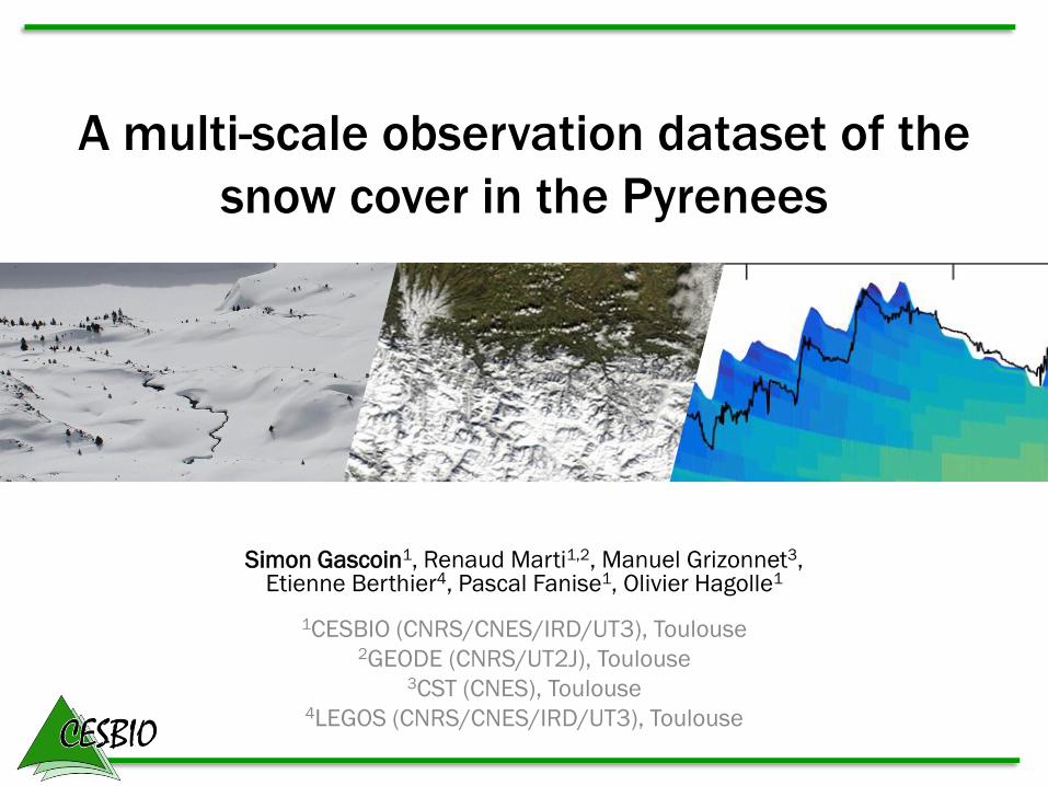
Simon Gascoin1, Renaud Marti1,2, Manuel Grizonnet3, Etienne Berthier4, Pascal Fanise1, Olivier Hagolle1
1CESBIO (CNRS/CNES/IRD/UT3), Toulouse 2GEODE (CNRS/UT2J), Toulouse
3CST (CNES), Toulouse 4LEGOS (CNRS/CNES/IRD/UT3), Toulouse
A multi-scale observation dataset of the
snow cover in the Pyrenees

Simon Gascoin1, Renaud Marti1,2, Manuel Grizonnet3, Etienne Berthier4, Pascal Fanise1, Olivier Hagolle1
1CESBIO (CNRS/CNES/IRD/UT3), Toulouse 2GEODE (CNRS/UT2J), Toulouse
3CST (CNES), Toulouse 4LEGOS (CNRS/CNES/IRD/UT3), Toulouse
A multi-scale observation dataset of the
snow cover in the Pyrenees
satellite

Importance of the snow in the Pyrenees

Importance of the snow in the Pyrenees
Crop irrigation
Hydropower
Ski

In situ snow monitoring network
R. Marti, PhD thesis
Winter snowline
Summer snowline

Presentation outline
• A snow cover area climatology from MODIS
snow products (NASA)
• A snow cover area product from Landsat-8
and Sentinel-2
• A peak snow depth product from Pléiades
stereo imagery

MODIS snow cover climatology
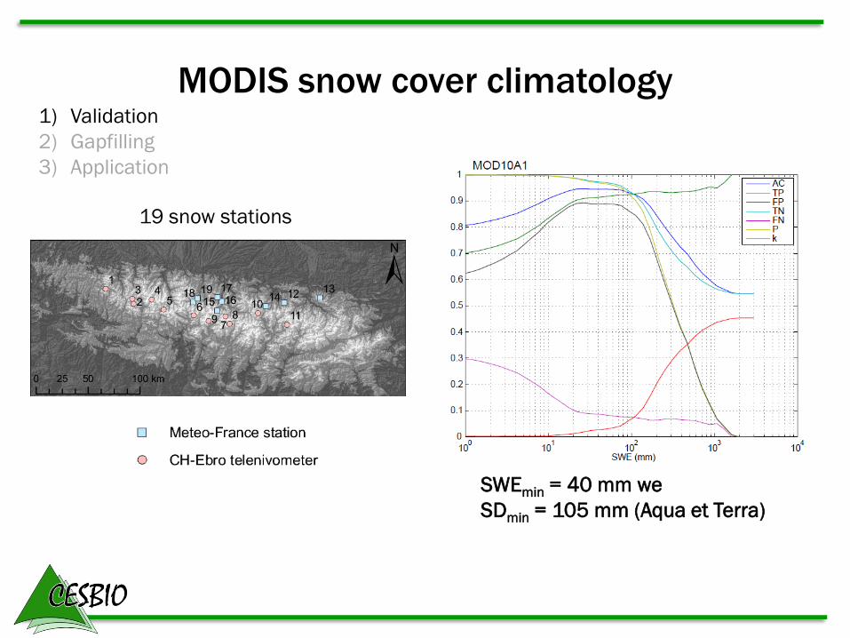
Aqua (MYD10A1) and Terra (MOD10A1)
binary snow products from NSIDC

MODIS snow cover climatology 1) Validation
2) Gapfilling
3) Application
157 Landsat dates Snow cover fraction
MODIS snow cover climatology
SWEmin = 40 mm we
SDmin = 105 mm (Aqua et Terra)
19 snow stations
1) Validation
2) Gapfilling
3) Application

MODIS snow cover climatology
Cloud fraction
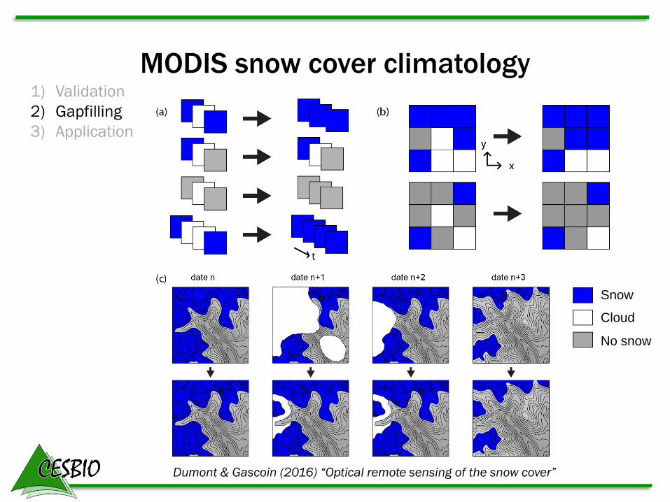
MODIS snow cover climatology 1) Validation
2) Gapfilling
3) Application
Snow
Cloud
No snow
Dumont & Gascoin (2016) “Optical remote sensing of the snow cover”
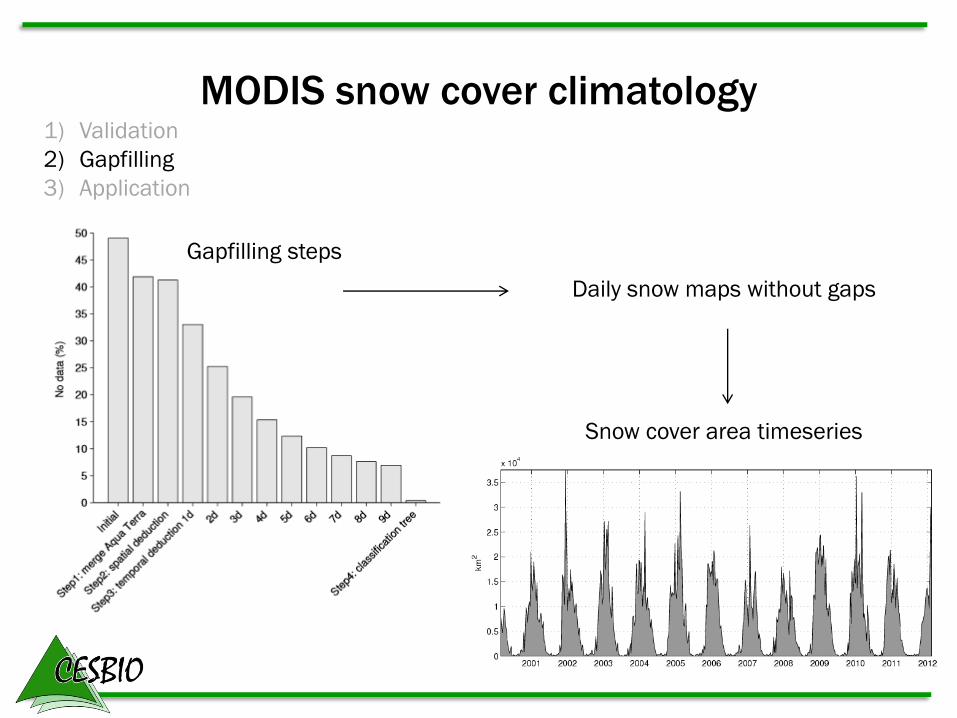
MODIS snow cover climatology 1) Validation
2) Gapfilling
3) Application
Gapfilling steps
Daily snow maps without gaps
Snow cover area timeseries

MODIS snow cover climatology 1) Validation
2) Gapfilling
3) Application Mean snow cover duration
by elevation band by slope aspect
Gascoin et al. 2015
“Snow cover climatology for the Pyrenees”

MODIS snow cover climatology
0
50
100
150
200
250
300
350
0
500
1000
1500
2000
2500
3000
3500
1 2 3 4 5 6 7 8 9 10 11 12
Total 2012 Total 1995-2012
Hydro 2012 hydro 1995-2012
Impact of 2012 snow deficit on Spain
national hydropower production

MODIS snow cover climatology 1) Validation
2) Gapfilling
3) Application Comparison with SURFEX-ISBA (Ariège à Foix 1340 km2)
Martin et al. 2016
Surv. Geophys.
Presentation outline
• A snow cover area climatology from MODIS
snow products (NASA)
• A snow cover area product from Landsat-8
and Sentinel-2
• A snow depth product from Pléiades stereo
imagery

MODIS vs. Landsat
MODIS 500-m, 1 day Landsat-8 30-m, 16 days
t
MODIS
Landsat-8

MODIS vs. Landsat
MODIS 500-m, 1 day Landsat-8 30-m, 16 days
t
MODIS
Landsat-8
Sentinel-2

Sentinel-2 TOA
Snow and cloud masks
Atmospheric and terrain correction
Cloud and cloud shadow
detection
Snow detection
neigeaNDSI
MIRVIS
MIRVISNDSI
Sentinel-2 and Landsat-8 snow product
DEM

First Sentinel-2 snow map
Central Pyrenees
06-Jul-2015 vs. Aug-2013…

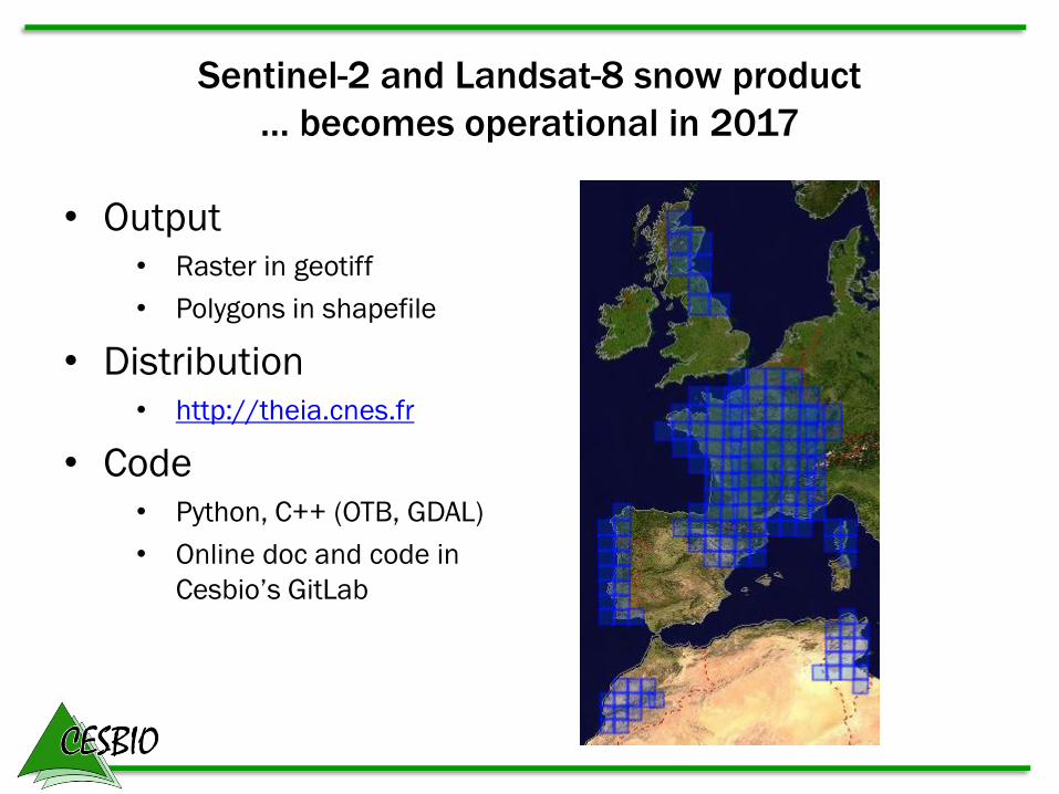
Sentinel-2 and Landsat-8 snow product
… becomes operational in 2017
• Output • Raster in geotiff
• Polygons in shapefile
• Distribution • http://theia.cnes.fr
• Code • Python, C++ (OTB, GDAL)
• Online doc and code in
Cesbio’s GitLab 57 Landsat-8 tiles of 110 km x 110 km
Sentinel-2 and Landsat-8 snow product
… becomes operational in 2017
• Output • Raster in geotiff
• Polygons in shapefile
• Distribution • http://theia.cnes.fr
• Code • Python, C++ (OTB, GDAL)
• Online doc and code in
Cesbio’s GitLab

Presentation outline
• A snow cover area climatology from MODIS
snow products (NASA)
• A snow cover area product from Landsat-8
and Sentinel-2
• A snow depth product from Pléiades stereo
imagery
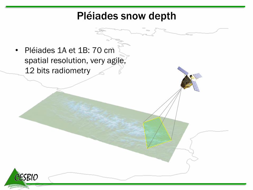
Pléiades snow depth
• Pléiades 1A et 1B: 70 cm
spatial resolution, very agile,
12 bits radiometry

Pléiades snow depth
• Pléiades 1A et 1B: 70 cm
spatial resolution, very agile,
12 bits radiometry
High resolution tri-stereo
imaging capability

Pléiades snow depth
26-Oct-2014 11-Mar-2015
Bassiès power plant watershed
Ariège, Pyrenees
Pléiades Tristereo
UAV survey
442 snow probe measurements (10-Mar-2015)
Pléiades Tristereo
UAV survey (13-Jul-2015)
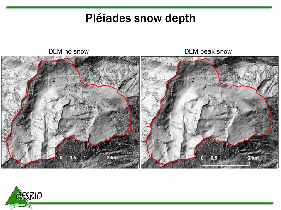
Pléiades snow depth
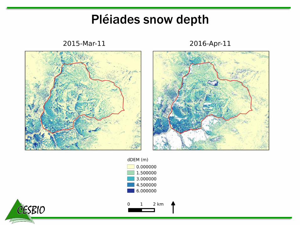
DEM no snow DEM peak snow

Pléiades snow depth
dDEM Comparison with snow probe data
Residuals:
median=-16cm
std=58cm
NMAD=45cm

Pléiades snow depth
Marti et al. 2016
Pléiades Drone
Pléiades snow depth

Summary
MODIS snow cover area
S2/L8 snow cover area
Pléiades snow depth
Mountain range
Watershed
Time (log)
Exte
nt
in k
m (
log)
500m
resolution,
every day
20m
resolution,
every 5 days
2m
resolution,
once a year

Data availibility
Email: [email protected]
Twitter: @sgascoin
Facebook: sgascoin
Skype: sgascoin
Tel. +33 5 61 55 86 68
Postcards: 18 ave. E. Belin 31400 Toulouse
Check our blog :
http://www.cesbio.ups-tlse.fr/multitemp/