a nabo and ipy field project 2010 excavations at
TRANSCRIPT

REU
A NABO and IPY field Project 2010 Excavations at Skútustaðir, Mývatn Northern Iceland:
Preliminary Field Report After the Excavation Season June – July 2010
Fornleifastofnun Íslands May 2011
FS 457-08273
Megan T. Hicks and Lilja Björk Pálsdóttir with
Þóra Pétursdóttir (FSI), Dr. Thomas H. McGovern, Aaron Kendall, Seth Brewington, Amanda Schreiner and George Hambrecht (all from CUNY). With C.U.N.Y Brooklyn College REU Program: Sophia Perdikaris (Director), Derya Gunyadin, Erin Friedman, Marissa Gamliel, Finessa Javier, Kimberly Kearns, Ingrid Lisudottir-Feeney, Ayo Oti, Reaksha Persaud, Joanna Tchurchenthaler & Jessica Vobornik.
2
Front page: A group photograph of the 2010 season team members
© Fornleifastofnun Íslands Bárugötu 3 101 Reykjavík Sími: 551 1033 Fax: 551 1047 Netfang: [email protected]

3
Table of Contents Samantekt á íslensku........................................................................................................... 4 Summary ............................................................................................................................. 6 Excavations in Area E3....................................................................................................... 9 Excavations in area H ....................................................................................................... 16 Faunal Analysis of Skútustaðir: a report on ongoing fieldwork and laboratory analysis. 24
Summary ....................................................................................................................... 24 Introduction................................................................................................................... 25 Field Season 2010: Recovery of Faunal Remains in Area H........................................ 26 Field Season 2010: Recovery of Faunal Remains in Area E3 ...................................... 28 Ongoing Laboratory Analysis....................................................................................... 30 Discussion..................................................................................................................... 32 Future Objectives: Field and Laboratory ...................................................................... 35 Reference ...................................................................................................................... 35
Skútustaðir 2010: Interim finds report.............................................................................. 37 E3 .................................................................................................................................. 37 H.................................................................................................................................... 38 Summary ....................................................................................................................... 38 Reference ...................................................................................................................... 38
Appendices........................................................................................................................ 39 Context register............................................................................................................. 39 Finds register................................................................................................................. 40 Sample register.............................................................................................................. 48

4
Samantekt á íslensku
Sumarið 2010 var haldið áfram að rannsaka bæjarhólinn að Skútustöðum í Mývatnssveit. Rannsókn á bæjarhólnum hófst þegar tekin voru borkjarnasýni á svæðinu árið 2007 en niðurstöður þeirrar borunar leiddu til uppgrafta sumurin 2008 og 2009. Búið hefur verið á Skútustöðum frá fyrstu tímum Íslandsbyggðar, jörðin jafnvel talin vera með þeim elstu við Mývatn og að hún hafi fljótt orðið miðstöð jarða við sunnanvert Mývatnið.1 Ýmislegt hefur komið fram við uppgröftinn sem styður háan aldur, gripasafnið bendir til búsetu á staðum allt frá landnámi og afstaða gjóskulaga við mannvistarlögin sýna einnig fram á búsetu frá fyrstu tíð. Rannsóknarmarkmið fyrir árið 2010 voru að halda áfram uppgreftri á svæði H sem byrjað var að grafa árið 2009 auk þess að opna nýtt svæði, E3, sem er vestan og sunnan við núverandi íbúðarhús. Á svæði H komu í ljós mikil ösku- og ruslalög sem hægt er að tímasetja nokkuð vel út frá gjóskulögum. Gjóskulögin sem komu í ljós voru frá 1717, tvö gjóskulög frá 17. Öld, þar af annað fá því snemma á 17. öld og loks lag frá 1477 sem var fjarlægt við lok uppgraftar en ekki var grafið niður fyrir það. Mikið fannst af dýrabeinum og gripum á svæði H og á þetta sérstaklega við um jarðlög frá 1550-1850 þó að einnig hafi verið mikið um bein og gripi á tímabilinu 1477-1717. Á hinu nýja svæði E3, sem er í framhaldi af E1 og E2 svæðum frá 2009, kom í ljós hlaðinn veggur. Veggurinn var hlaðinn úr torfi og grjóti en grjótið hefur verið hlaðið utan á þá hlið sem sjáanleg var innan uppgraftarmarka. Í torfi var að finna bæði landnámsgjósku og 940 gjósku. Hann hefur verið hlaðinn á tímabilinu 940-1262 því að síðarnefnda gjóskan lá óslitin yfir veggnum. Ekki voru önnur mannvirki rannsökuð á Skútustöðum þetta árið. Vísbendingar um að reynt hafi verið að bæta tún á Skútustöðum með því að dreifa þunnum lögum af ösku og torfsneplum yfir svörð var að sjá á svæði E3. Við uppgröft kemur þetta fram sem þynnri lög eða linsur af mismunandi jarðefnum en þegar um hefðbundin ruslalög er að ræða. Þó ber að nefna að einnig gæti verið um endamörk ruslahaugs að ræða þar sem lögin verða mjög þunn til endanna. Þessar vísbendingar um jarðabætur eru þó ekki síður mikilvægar í ljósi þeirrar jarðeyðingar sem virðist hafa orðið þess valdandi að búskapur á tveimur jörðum í nágrenni Skútustaða, Sveigakot og Hrísheimar, lagðist snemma af á meðan Skútustaðir hafa haldist í byggð allt til dagsins í dag. Í beinasafninu er mest af kinda- og geitabeinum en einnig er hátt hlutfall af nautgripabeinum miðað við aðra staði í Mývatnssveit sem hafa verið rannsakaðir. Þá er einnig athyglisvert að bein sjávarfiska finnast á Skútustöðum í bland við ferskvatnsfiska.
1 Ágústa Edwald, ritstj. 2010. Öskuhaugsrannsóknir á Skútustöðum í Mývatnssveit 2009. Framvinduskýrsla II. Fornleifastofnun Íslands. Reykjavík. Bls. 7.

5
Gripasafnið er athyglisvert og fjölbreytt, en þar er að fina gripi allt frá því fyrir 1262 og til 20. aldar. Listafallegir útskornir gripir eru meðal annarra merkilegra gripa sem fundist hafa á Skútustöðum þetta árið. Á Svæði H hafa flestir gripirnir fundist í jarðlögum milli gjóskulaga frá 1477 og 1717 en á svæði E3 eru flestir fundnir í jarðlögum sem eru tímasett til miðalda. Nánari greining á gripum sem fundust 2010 fer fram samhliða greiningu á gripum sem kunna að koma í ljós 2011. Uppgröftur mun halda áfram á Skútustöðum sumarið 2011.

6
Summary
In 2007 a joint FSÍ/CUNY NABO team, conducting a coring and test trenching survey, visited Skútustaðir following the discovery of a patch of eroding midden, noted by Árni Einarsson ( of the Mývatn Research Station). Investigations in 2008, lead by Agusta Edwald and Thomas H. McGovern, followed up on the 2007 results with a set of test trenches. The three 2008 test units (D, E1&2, and F) located midden deposits with excellent organic preservation and multiple tephra horizons. Artifacts recovered and tephra observed in area D indicate that the deposits sampled date from ca. 1717-1477, E1 & 2 have an early Viking Age deposit directly upon the Landnám surface, and F revealed a very rich early modern midden deposit and an unexpected structural wall. The 2009 season saw a major expansion of the area D unit into two connected larger units G (13 sq m) and H (20 sq m). Unit G was carried-out down to lava bedrock, revealing an exceptionally productive Viking Age midden deposit packed into the natural fissures and crevices. Large artifact and eco-fact collections were recovered from the early modern and Viking age deposits, with excellent conditions of preservation throughout.
Objectives for the 2010 season included further excavation in Area H, where extensive deposits, in some places nearly two meters deep, are known to be present. In addition a new area was opened a midden near the contemporary house of Gerður Benediktsdóttir. Excavations of test pits E1 and E2 in 2008 indicated that deposits in the new area could be dated to the Viking age. In addition to adding to the collection of ecofacts and artifacts, we successfully integrated undergraduate students-in-training into our research process. Last, structural remains were unexpectedly found in the northern edge of area E3- further indication of the rich archaeological record at Skútustaðir. The structural remains were not excavated or otherwise disturbed as that was not within the scope or permit of the project.
Several related projects were carried out during the 2010 field season. These included the production of a blog and multimedia teaching tool composed by Aaron Kendall (CUNY, Ph.D. program in Archaeology). In addition, we collaborated with the local archaeological association, Hið þingeyska fornleifafélag, working closely with friend and host Unnsteinn Ingason in building a community consisting of local and international groups support of archaeology in Þingeyjarsýsla. Visiting student trainees from the Research Experience for Undergraduates (REU) program lead by Dr. Sophia Perdikaris from CUNY Brooklyn College. Collaboration continued with the Hið þingeyska fornleifafélag and the Litlulaugaskóli and Hafralækjarskóli KAPI (Kids Archaeology Project Iceland, formerly Fornleifaskóli barnanna). The project is part of a larger NABO (North Atlantic Biocultural Organization) and IPY (International Polar Year) program Human Ecodynamics in the North Atlantic, which works to coordinate international interdisciplinary projects in the Shetlands, Faroes, Iceland, and Greenland

7
(see www.nabohome.org). KAPI (Kids Archaeology Project Iceland) is locally headed by Sif Jóhannesdóttir and Pétur Ingólfsson with collaboration from the REU program.
The excavation of the rich multiperiod site was lead by Þóra Pétursdóttir (FSI) and Dr. Thomas H. McGovern (CUNY Hunter College). Excavators, all from CUNY PhD program in Archaeology include, Seth Brewington, Frank Feeley, Megan Hicks, Aaron Kendall, and Amanda Schreiner. Óskar Gisli Sveinbjarnarson of FSI contributed expertise in GIS and mapped the 2010 trenches and Lilja Björk Pálsdóttir (FSÍ) assisted with post excavation work.

8
Figure 1 The location of Skútustaðir and other lake Mývatn archaeological sites (map by Oscar Aldred).

9
Excavations in Area E3
Area E3 formed an “L” shape around the southwestern corner of the modern building. The area was truncated to the east by two areas excavated in 2008 (E1 and 2) as well as the home itself. The trench edges and corners do not align with the site grid created in 2008. Instead, Óskar Gísli Sveinbjarnarson established absolute points using a trimble and ARGIS software.
Figure 2. The opening day for the 2010 excavations included unturfing a large area (E3) around the contemporary home. Intact midden layers and improved homefield soils compose the ground surface and subsurface, except from the small builders- thench cut around the home at approximately one to two meters out from the modern structure’s edges.
After unturfing in area E3, we were able to work back from a clear profile of midden deposits, soil amendment deposits and tephra layers that were previously exposed by the excavation of areas E1 and E2 in 2008. Very intact, flat surfaces of the V1717 tephra and the V1477 tephra were easily encountered beneath relatively homogeneous soil layers containing very scant anthropogenic debris.

10
Such deposits including thinly dispersed domestic waste may likely relate to those
described as soil amendments, i.e. varying types of waste added to soil to improve its fertility (Adderly et al 2008). The deposits may be the result of past inhabitants lightly distributing refuse around the home field to fertilize and increase hay production. It is highly significant that the build-up of home field soil at Skútustaðir sharply contrasts the farming landscapes to the south that surround the archaeological farms of Sveigakot and Hrísheimar -which lost soil and productive land to the extent that this may have contributed to their abandonments.
Figure 3. The V1477 tephra is removed on to a medium brown soil amendment
deposit. The ground surface is uniform and soil- rich at this juncture, but a portion of the uneven bedrock, encountered later in the excavation, is just barely visible in
the profile.
When the V1477 tephra was excavated, the team noted a cracked ground surface. The tephra ran into deep fissures and lines converging in polygon shapes resembling frost polygons. The cracking ran through several stratigraphic units, creating uneven surfaces and was visible in the profiles. In other places, stratigraphy was visibly interrupted by a shift in vertical position of the ground surface. This frost cracking and vertical disturbance was noted in Area E3, though not in Area H.
Excavation down to the 1300 tephra began to reveal a more uneven landscape, with lava bedrock crags appearing in slopes and ridges. Deposits including midden, turf, and gravel were found to have also been spread in E3. It’s possible that residents intentionally spread these materials as general soil amendments or potentially over the tephra.

11
After the excavation of the deposits below the H1300 tephra, a ridge of lava bedrock emerged which divided the deposits in Area E3. To north side of the bedrock ridge within the trench, deposits lay in a basin created by the bedrock and to the south, deposits lay flat on a more evenly sloped and higher plane of loose bedrock gravel, without the deep bedrock ravines below that we would later find.
Figure 4. REU Kimberly Kearns (Brooklyn College) and George Hambrecht (CUNY Ph.D. program) begin to excavate the baulk at the eastern end of area E3. The baulk extends to a truncation by a late 20th century builder’s trench dug for utilities and delimits the eastern extent of area E3. We encountered southward sloping deposits in the northern side of Area E3 that, when removed, were overlying the remains of the edge of a turf and stone wall. Several stones, approximately 20-30 centimeters in length, were aligned in an east-west direction with turves apparently packed around them. The entire feature lay under the 1262 tephra and the turves contained both the landnám tephra and the V940 tephra placing the wall’s construction at post 940 CE and predating 1262 CE. As more deposits were removed, we found the crevices in the lava surface were deep, and the remains of the wall ran along a ridge of lava bordering a steep drop into the crevice.

12
Figure 5. A small portion of the remains of a wall are uncovered on the north side of Area E3. This photograph was taken on July 14th 2010.
Figure 6. The above images show the NE corner of trench E3. The stone and turf wall is becoming visible as is the ravine in the lava bedrock which spread over this area in 300 BC, before it was settled. Aaron Kendall (CUNY PhD program) works
in the ravine that is depicted below after being excavated down to the natural ground surface.

13
100
204
200
205
12 1717 tephra
206
14 1477 tephra
211
215
225 16 1410 tephra
217 216
222
223
226
228 1300 tephra
230
232 1262 tephra
241 233 237
238 242
247 240245 243
248 w.950 tephra255
250
Natural Natural LNS/NAT
SKU '10 - Area E3
=
=
Figure 7. Matrix for area E3.

14

Frost action
Context numberAreaTypeDescription200E3dBrown soil204E3dgrey coarse tephra ??205E3dmedium brown cultural deposit, very low conc. 206E3dmedium brown cultural deposit, very low conc. 211E3dbrown unform deposit (soil amendment??)(Frost crack)215E3ddark brown deposit216E3dlt brown deposit with small amount of midden material217E3dmedium brown midden deposit, much bone and art. Below 1477 above 1410222E3dmed brown midden deposit with ash lumps223E3ddark brown midden deposit filling depression in N side of E3 along E1 profile, many bones225E3d1410 tephra226E3dMedium brown midden below 1410227E3dMedium-light brown soil below 226228E3d1300 tephra230E3dMottled tan deposit with pebbles below 1300232E3d1262 tephra surface, black, thin233E3dGravel and midden fill between 1212 and 1158235E3dTephra: H 1158236E3dTurf deposit237E3dTurf collapse=[233]--> (fallen out as one)238E3dGravel and turf debris240E3dMottled brown with gravel below 1262 and above LNS241E3dBrown silt below 1262242E3dOrange midden between turf wall and rock formation243E3dTurf debris with charcoal lenses and gravel245E3dMixed soil with tephra (landnam) in gravel substrate247E3dMixed midden in crevice248E3dTurf deposit in lava crevice249E2dAsh and charcoal deposit on top of natural = context250E3dSilty midden with windblown tephra255E3gTurf and rock wall in North of trench


16
Excavations in area H Turf, in-fill and protective teram fabric were removed off of Area H on the first excavation day, to reveal the archaeological levels left in place in 2009. In 2009, excavation ended at contexts lying just below the 1717 tephra. The 2010 excavation unit differed slightly in extent: the trench’s northern and southern boundary were consistent with the previous years (being four meters apart, however the western boundary was a baulk of turves placed to protect H from the backfill of the contiguous area G. This baulk was approximately 64 cm wide so it should be noted that the western side of trench H no longer corresponds with an even meter on the site, grid, but that distance off of it. The eastern end of the trench was extended by one meter to compensate for the loss on one meter on the western end, making the total length of the excavated area 8 m and 36 cm. This eastern end was reduced to come into phase with the main body of the trench and the context relations were as follows.
2009 2010100 201
120 202
122 203
124 207
125 208
127 209
129 2102009
130 212 153
118 213 1717 Tephra
214
218 early‐17th c. tephra
219
220
221
224
C. 1610‐1640 pipe bowl 229
231
234
239
244
246
Unidentified tephra 251
252
253
256
1477 tephra 254
EOS
SKU 2010 - Area H
=
=
=
=
=
=
=
=
=
Figure 8. Matrix for area H 2010 and corresponding contexts from 2009.

17
Figure 9. Area H, Context [229] contained a 1610-1640’s “WS” pipe bowl to aid in dating stratigraphic units between the V1717 tephra and the V1477 tephra). The deposits are very deep, and consist of dense midden until they neared the V1477 tephra. Comparisions of the pipe’s stamp with the Museum of London’s information archive indicated that the maker was possibly William Sterridge. This date and identification should be re-confirmed by a specialist.

18
Figure 10. A knife handle and a carved figurine from area H.
19
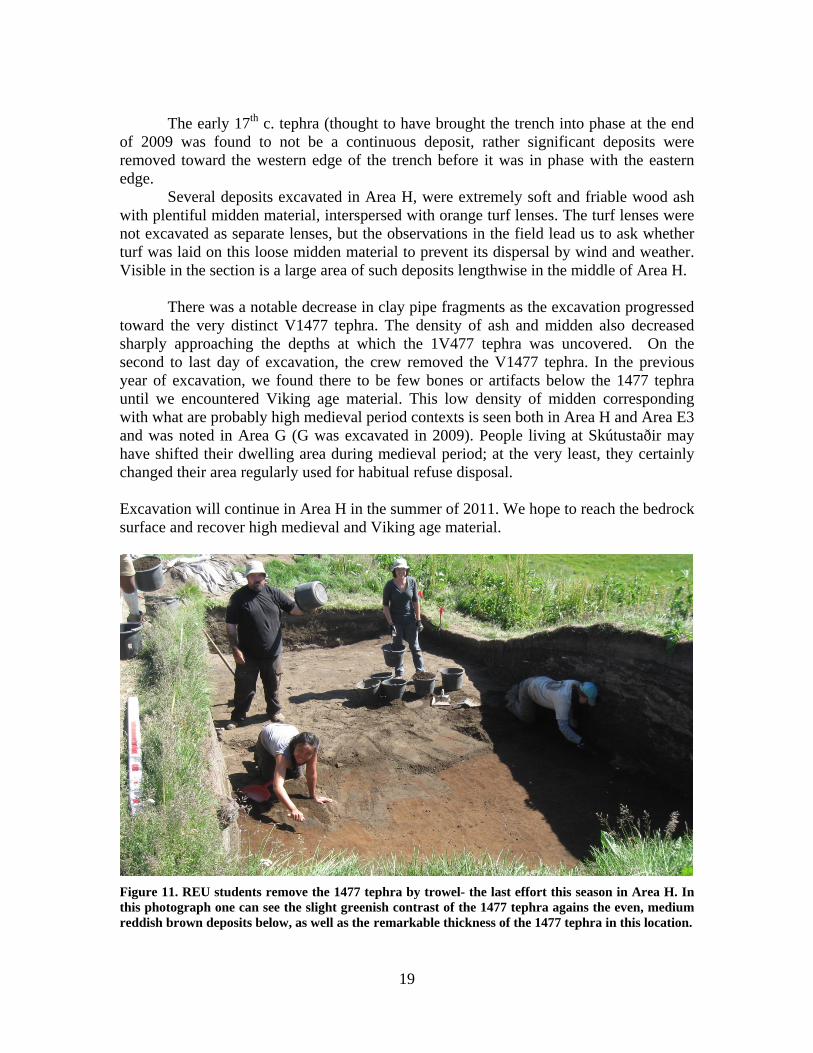
The early 17th c. tephra (thought to have brought the trench into phase at the end
of 2009 was found to not be a continuous deposit, rather significant deposits were removed toward the western edge of the trench before it was in phase with the eastern edge.
Several deposits excavated in Area H, were extremely soft and friable wood ash with plentiful midden material, interspersed with orange turf lenses. The turf lenses were not excavated as separate lenses, but the observations in the field lead us to ask whether turf was laid on this loose midden material to prevent its dispersal by wind and weather. Visible in the section is a large area of such deposits lengthwise in the middle of Area H.
There was a notable decrease in clay pipe fragments as the excavation progressed toward the very distinct V1477 tephra. The density of ash and midden also decreased sharply approaching the depths at which the 1V477 tephra was uncovered. On the second to last day of excavation, the crew removed the V1477 tephra. In the previous year of excavation, we found there to be few bones or artifacts below the 1477 tephra until we encountered Viking age material. This low density of midden corresponding with what are probably high medieval period contexts is seen both in Area H and Area E3 and was noted in Area G (G was excavated in 2009). People living at Skútustaðir may have shifted their dwelling area during medieval period; at the very least, they certainly changed their area regularly used for habitual refuse disposal. Excavation will continue in Area H in the summer of 2011. We hope to reach the bedrock surface and recover high medieval and Viking age material.
Figure 11. REU students remove the 1477 tephra by trowel- the last effort this season in Area H. In this photograph one can see the slight greenish contrast of the 1477 tephra agains the even, medium reddish brown deposits below, as well as the remarkable thickness of the 1477 tephra in this location.

20
Figure 12. The 1477 tephra was cleaned on to a surface that appears to have been stepped on the eastern end, possibly by past turf cutting. Bedrock is emerging but deposits are deep in other areas of the area H. The V1477 tephra was the last context to be excavated in 2010 in Area H.
Figure 13. The final view of the southern (north facing) profile in Area H clearly shows the friable grey ash, bone and turf (in a wedge that thickens to the west) that composed much of the material removed in 2010. Below the ashy deposits were more silty deposits containing fewer bones and artifacts, following a similar pattern to findings in 2009: late medieval deposits contained more silt and less bone and were less artifact- rich than the early modern deposits.

21

100
124
125118144218
219
224
231239251253254
246
252 253251
125
234
229
221
219136
118
256
239
229
EW
SKU10_H_PX_Profile1m
Context numberAreaTypeDescription200HdBrown soil201HdSand and pebble deposit under topsoil202Hdtephra 1717 and ash deposits203Hdmedium brown deposit with charcoal207Hdgrey brown midden deposit208Hdgrey midden deposit209HdBrown grey mottled midden deposit210Hdlt grey brown midden deposit212Hdpink to lt brown burnt peat ash deposit213Hdtephra (early 16th c ??). End point of 2009 excavation in H214Hdlensed midden deposit218HdPossible early 17th c tephra, cleaned off219Hdmedium brown bone rich midden deposit220Hdgreyish brown wood ash deposit221HdBrown grey mottled midden deposit224Hddark grey brown fine mottled midden229HdGrey brown midden deposit with turf lenses231HdMid-grey finely mottled miden deposit234HdBrown (mid) mottled midden deposit239HdUniform brown deposit244HdCharcoal rich midden deposit246HdAshy midden layer251HdTephra, unidentified tephra above 1477 (early 16th c.)252HdGrey midden dump253HdLight brown windblown soil254Hd1477 tephra256HdDark midden above 1477 tephra


23
References
Edwald, Ágústa et al. 2009 Excavations at Skútustaðir 2008, FSÍ field Report
Adderly, W. Paul, Ian A. Simpson and Orri Vésteinsson. 2008. Local-Scale Adaptations: A Modeled Assessment of Soil, Landscape, Microclimatic, and Management Factors in Norse Home-Field Productivities. www.nabohome.org

24
Faunal Analysis of Skútustaðir: a report on ongoing fieldwork and laboratory analysis
Megan T. Hicks Ph.D. Program in Archaeology City University of New York
[email protected] 3/30/11
Summary Intensive archaeological study of the Mývatn area of northern Iceland has been an
ongoing focus of international, collaborative teams for two decades (McGovern et al
2007, Vésteinsson ed. 2008). Skútustaðir, a long term farming site in the same region,
occupies a unique niche within these works as it has so far yielded the most continuous
archaeological record of farming, subsistence, diet and economy, when compared to the
faunal record from several other sites. A combination of dense and well-preserved
midden deposits and the presence of several volcanic tephra isochrones make this site
ideal for extensive study (McGovern in Vésteinsson ed. 2008). Analysis of the
Skútustaðir faunal collection is currently being carried out by the present author at the
City University of New York, Hunter College and Brooklyn College NORSEC
Zooarchaeological Laboratories. The preliminary results are summarized here.
Skútustaðir’s archaeofauna points to a focus on caprines (sheep and goats) but also
indicates long- term cattle raising at possibly a higher degree than surrounding farms.
Marine fish are present, potentially increasing during the early modern era (1550-1850
CE). Also present in the archaeofauna are horses, pigs, seals in low numbers and several
species of birds. Analysis is ongoing. For detailed reports, please refer to the NABO
website: www.nabohome.org
The Research Team

25
Dr. Thomas H. McGovern (CUNY) and Þóra Pétursdóttir of Fornleifastofnun
Íslands (FSÍ) led our team which included students from the CUNY Ph.D. program: Seth
Brewington, Francis Feeley, George Hambrecht, Megan T. Hicks, Aaron Kendall and
Amanda Schreiner. The 2010 field efforts were greatly enhanced by the REU (Research
Experience for Undergraduates) program under the direction of Dr. Sophia Perdikaris of
(CUNY) Brooklyn College. Reaksha Persaud, and Jessica Vobornik, (both
undergraduates from Brooklyn College) joined us as senior members of the REU
program. New REU students included Ayo Oti, Kimberly Kearns, Derya Gunayaden,
Joanna Tchurchenthaller, Ingrid Feeney, Finessa Javier and Jade de la Paz. We worked
alongside archaeological teams pursuing related projects nearby from FSÍ who
generously lent their assistance in the first days of excavation. Óskar Gísli
Sveinbjarnasson (FSÍ) aided us in the establishment of fixed GPS points to delineate our
trenches with the help of David Stott. Magnús Sigurgeirsson lent his expertise in
identifying volcanic tephras in situ.
Acknowledgements
Many thanks to the scholars who have built the foundations for this research and are cited within this paper. Thanks also to local friends and collaborators: Unnsteinn Ingasson and his entire family, Árni Einarsson, the Director of the Mývatn Research Station, collaborators from KAPI (Kids Archaeological Project, Iceland) and the current residents of Skútustaðir, especially Gerður Benediktsdóttir, for ongoing collaboration, assistance, and for welcoming our team in to the area. Many of us regard Þingeyjarsýsla and the Mývatn region as a second home because of the generosity of these friends of our project. Funding support from the U.S. National Science Foundation Office of Polar Programs Arctic Social Science Program through International Polar Year grant 0732327 is gratefully acknowledged. This report is a product of the International Polar Year program and of the NABO research cooperative.
Introduction Investigations at Skútustaðir emerged out of a regional-scale research design
called Landscapes of Settlement that was initiated by Orri Vésteinsson and Adolf
Friðriksson. The collective work aimed to describe through archaeology, past regional
settlement patterns, economic developments, social histories, and environmental histories
of Mývatnssveit. Thus far, the majority of the archaeofaunal collections excavated in the
Mývatn area dated to the Viking period and the subsequent medieval period, but none
had been recovered from the early modern period. Seeking a broader chronology, Orri

26
Vésteinsson led an Mývatn regional survey which was carried out by CUNY
archaeologists. This research was conducted under the project entitled Human and Social
Dynamics in Myvatnssveit, Iceland, from the Settlement to the Present, directed by Astrid
Ogilvie. Efforts were focused on locating a site with an archaeofauna that included late
medieval and post medieval remains (ca. 1300-1900). Following a very promising 2007
coring survey at Skútustaðir (McGovern in Vésteinsson ed. 2008), four test trenches were
excavated in 2008: Area E 1& 2, Area D, and Area F. A full report is available as Edwald
and McGovern 2008. The 2009 field season included additional trench Areas G and H
and the results are described in Edwald 2009 and Hicks 2010.
Field Season 2010: Recovery of Faunal Remains in Area H Excavations continued in Area H from the 2009 field season. During the 2009
season, the upper strata of Area H were found to be rich in well-preserved midden
remains pertaining to the early modern period (1550-1850 CE). In 2009, excavation was
carried out only through early modern strata so the 2010 field team aimed to excavate
Area H as far as possible.
In 2010, Area H was extended down slope to the east by one meter. It measured
4m in width by 8 m and 36 cm in length. We were able to recover bone and artifacts from
rich contexts both above and below the V1717 tephra. The chart below details that faunal
finds were especially rich in the early modern context [246] and there was good recovery
throughout the site phase defined between the V1717 and the V1477 tephras. It should be
noted that as a result of significant volumes gravel being recovered along with the faunal
remains context [246], the documented number of bags is inflated to some degree. Gravel
was recovered along with the bones to maintain time-efficient ant total recovery of sieved
material, as context [246] was a mixture of small mammal bone fragments, small fish
bones and small (1 cm) gravel.

27
Figure 2. The chronological grouping of the recovered bones is based on identification of volcanic tephras V1717 and V1477 in situ kindly provided by Magnús Sigurgeirsson. This chart depicts 142 bags of bone recovered from area H. Additionally, three bags of unstratified bone were recovered, which normally includes a very small amount of bone from a profile cleaning or surface find, hand collected and does not actually indicate a full bag.
Excavations in 2010 ended with the removal of the V1477 tephra on to a deposit
that appears to have been truncated by past turf cutting. We expect that the proposed
2011 field season will allow us to carry excavation in Area H down to the lava bedrock
and to reach a particularly important deposit that was present in the contiguous Area G.
This deposit was an anthropogenic, bone, rich in-filling of a crevice in the lava bedrock
surface that closely related to the V940 tephra (context [161]). The complete excavation

28
of Area H is crucial for the recovery of well-preserved faunal remains from several
phases.
Field Season 2010: Recovery of Faunal Remains in Area E3 Area E3 was laid out and excavated in 2010 after Viking age and medieval
midden remains were uncovered in closely located units (E1 and E2) during the 2008
field season. It measured 9 meters on the western side, 11 meters on the southern side and
4 meters on the northern side. The remaining trench edge was a curving open profile from
excavation season 2008, arching around the home of Gerður Benediktsdóttir. In area E3
we hoped to expand our faunal collection from the medieval occupation phase of
Skútustaðir. While recovery was excellent from some contexts in E3, others were mostly
devoid of the rich archaeological deposits encountered elsewhere within the site. The
majority of layers in E3 were composed of silty soils with occasional charcoal and bone
and low densities of artifacts. Instead of looking like the characteristic rich middens,
commonly preserved in Iceland, these deposits resembled soil amendments, soils
enriched by the addition of domestic waste, manure and other materials, as described by
Ian Simpson in his work on infield soil characteristics on farms in the north Atlantic
(Simpson et al. 2002). Another possibility is that the deposits with thinly dispersed ash
and bone could be the edges of thicker midden deposits, thinning as they spread outward
from a concentrated area.

29
Figure 3. The bags of bone are phased chronologically using volcanic tephras identified in the field by Magnús Sigurgeirsson. Two contexts, each yielding one bag of bone, were not included in this tally. Unstratified bone (3 bags) was also left out.
Aspects of excavation in Area E3 are reviewed in detail in the main body of the
2011 field report, however, there are some important additional notes regarding recovery
of faunal remains. The majority of osseous finds were recovered from contexts between
the H1300 and V1410 tephras, while from most other contexts, one bag of bone on
average was recovered. Faunal analysis benefits increasingly with greater sample sizes,
so the excavation of Area E3 will certainly benefit our understanding of farming, diet,
and economy in the high medieval to the late medieval phase. It is worth re-iterating here
that Area E3 demonstrated and reconfirmed that Skútustaðir’s archaeological sequence is
run through with a comparatively high number of tephra, providing very secure and
sometimes high- resolution dating.
The depositional patterns of the faunal remains at Skútustaðir clearly changed
through time. Based on changing density of midden material, some areas are used
intensively for periods and then fall out of use. This likely compliments changes over
time in settlement organization, the placement of domestic spaces, work-spaces, animal
enclosures, infields, and storage areas. The decisions regarding where to dispose of

30
disused items relates to and shadows other aspects of use of space, and in this way hints
to the variety of processes that make up the archaeological site. As Skútustaðir is a large
site whose remains are segmented by numerous tephras, it seems it would be worthwhile
to carry investigation into other realms of past uses, such as those of domestic spaces or
sacred and burial places. As these phenomena are often interrelated in complex ways to
the economic activity observable the midden remains.
Ongoing Laboratory Analysis The most complete report resulting from the ongoing faunal analysis (Hicks 2010)
is available on the NABO website nabohome.org, and the results are summarized here.
Laboratory Methods
Analysis completed so far was carried out at the Hunter College
Zooarchaeological Laboratory and made use of the extensive reference collections there.
Analysis of the fish bones recovered in 2008, 2009, and 2010 will be carried out at the
Brooklyn College and the Hunter College Zoorchaeological Laboratories. All elements
(bird and mammal) were identified as far as taxonomically possible (a selected element
approach was not employed) but most mammal ribs, long bone shaft fragments and
vertebral fragments were assigned to “Large Terrestrial Mammal” (cattle or horse sized),
“Medium Terrestrial Mammal” (sheep, goat, pig or large dog sized), and “Small
Terrestrial Mammal” (small dog-fox sized). Only elements positively identified as Ovis
aries and Capra hircus were assigned to the separate sheep and goat categories
respectively while all other sheep/goat element were assigned to the “caprine” category
potentially including both sheep and goats.
Digital records of all data collected were made following the 9th edition of the
NABONE recording package (a Microsoft Access database supplemented with
specialized Microsoft Excel spreadsheets). The animal bones excavated will be
permanently curated at the National Museum of Iceland. This report, other reports and
data are available from [email protected] and the NABO website:
www.nabohome.org.
Curation followed the NABONE protocols followed for other archaeofauna from
Iceland, Faroes, Greenland, and northern Norway. Following widespread North Atlantic

31
tradition, bone fragment quantification makes use of the Number of Identified Specimens
(NISP) method (outlined in Grayson 1984).
Species Present

32
Discussion Among domestic mammal bones analyzed from Skútustaðir, caprines (sheep and
goats) are the most common. This follows a general pattern for the lake Mývatn area
where during the time of settlement (871 – 950 CE) there may have been some livestock
diversity, but by the medieval period, the most common animals were caprines, followed
by cattle (Brewington et al 2004). Caprines were kept for wool, meat and dairy products.
33
Skútustaðir seems to have a high relative number of cattle (Bos taurus domesticus)
compared to other Mývatn region farms studied archaeologically. Where some Mývatn
area farms had 22 sheep (Ovis aries) for every cow, Skútustaðir seems to stay well below
ten sheep for every cow, throughout its record (Brewington et al 2004, Hicks 2010).
The high ratio of cattle apparently kept at Skútustaðir joins the archaeology with
ongoing discussions regarding environmental change, past land use, value, and social
change in Iceland. This dialogue is best illustrated in McGovern et al. 2007, Vésteinsson
2008 and Vésteinsson 2000. To summarize some key points, the productivity and value
of land in Iceland was linked to its infield hay production capacities and cattle holdings.
Cattle depended on hay cultivation to a high degree. Cattle rearing became linked to
productive, wealthy elite farms and thus a marker of status. As Skútustaðir appears to be
a long-term elite farm, the ongoing description and study of its economy will lend
important new information to studies of the changing socio-environmental conditions of
Iceland over a long period of time. This ongoing conversation highlights the cross-
disciplinary nature of the study of Iceland’s environmental and social past. It will be
worthwhile to apply the archaeofauna from Skútustaðir to carry this discussion through
the early modern period as it is a central issue in landscape change in the Mývatn area
(McGovern et al 2007, Dugmore et al 2005).
Horses (Equus caballus) and pigs (Sus scrofa) are relatively scarce in the faunal
collection when compared to caprines and cattle. It has been suggested that horses were
not typically eaten in Iceland (especially after ca 1000 CE) because of Christian
prohibitions on eating horseflesh. However evidence through space and time in the
archaeological record of Iceland suggests that these prohibitions were irregularly heeded.
Fish species have not yet been analyzed though analysis will commence after the
2011 field season. It was noted both in the field and can be seen in the above chart, that
use of fish species appears to increase. More work needs to be done here to securely
assert such a pattern and it is currently a preliminary suggestion. Species visible in
preliminary observations in the field include members of the cod family (Gadidae) as
well as Salmon (Salmo salar), Trout (Salmo trutta) and Char (Salvelinus alpinus).
Scant bird bones demonstrate a low relative frequency of birds being consumed
compared to other animals. Bird species found throughout the site include mallards (Anas

34
platyrhynchos), red breasted merganser (Mergus serrator), scaup (Aythya marilla), swans
(Cygnus sp.), swan/goose sized specimens, slavonian grebe (Auritus podiceps), long-
tailed ducks (Clangula hyemalis) and one specimen of gull (Larus sp). Another present
avian species was ptarmigan (Lagopus mutus), a local terrestrial bird. One sea eagle claw
(Haliatus albicilla) was found in an unstratified context. In addition, domestic chicken
(Gallus gallus) was represented among avian fauna.
Most notably, the team repeatedly unearthed compact, thin, but horizontally dense
layers of eggshell in situ during all excavation seasons. A research design is still being
formulated to obtain information (such as species identification) from these remains, but
they are well documented and sampled. The eggshell most likely belongs to eider ducks
(Somateria molissima) that congregate in a small chain of lakes about two hundred
meters to the east of the main cluster of modern homes at Skútustaðir. Egg collection has
been a long-term practice of Icelanders and there is documentary and archaeological
evidence that it has been strictly managed for sustainability over the long term
(McGovern et al 2007).
Seal remains (Phocidae) are present but rare; it is significant to note that the
nearest stretch of seacoast is 60 km distant. Seal bones so far appear to predominantly be
distributed amongst early modern contexts. Though it is early in analysis- a preliminary
pattern may at least be suggested for further inquiry; that seal remains and marine fish
remains (both from the coast) increase into the early modern period (1550-1850 CE).
Remains of Arctic fox (Alopex lagopus) and mouse (Mus musculus) were not
included in the bar chart above, as they are not necessarily indicative of economic
patterns at the farm in the same manner as the other species/taxa listed; that is, they are
not likely food items. Very few fragments of each were present among material analyzed
so far.
Molluscan remains from the coast are also present but uncommon. Other scholars
have suggested that they were incidentally introduced inland, traveling on seaweed used
for salt production or to pad cargo from the coast.
For an in-depth discussion of taphonomy, age at death patterns, and metrical analysis
of the collection analyzed so far, see Hicks 2010 available on the NABO website
(www.nabohome.org).

35
Future Objectives: Field and Laboratory The most singular aspect of Skútustaðir’s archaeological record is its chronological
distribution: artifacts and faunal remains recovered so far have spanned from the Viking
age through the early modern period. This will allow for a thorough analysis of how
people farmed, fed themselves and interacted economically over the long term.
It would be beneficial to include the following objectives within the research design
for the 2011 field season:
1. to complete recovery of archaeological material in Area H and carry excavation
down to the natural ground surface.
2. to locate an additional area where high medieval midden deposits may be
present either for excavation in a future season or for a test pit in the 2011
season.
Goals for laboratory work include the analysis of fish skeletal remains from Skútustaðir
for a more complete picture of the use of non- terrestrial resources through time. Special
focus for laboratory work in 2011 will be placed on material from the medieval period
and it is hoped that faunal material from the 2010 fieldwork in Area E3 will fill current
gaps in our knowledge of past activity at this site by enlarging our current data sets.
References Brewington, Seth. Ramona Harrison, Colin Amundsen and Thomas H. McGovern. 2004. An Early 13th Century Archaeofauna from Steinbogi, Mývatn District, Northern Iceland. Norsec Report No. 13. Dugmore, A.J., Buckland, P.C., Church, M.J., Edwards, K., Lawson, I., MgGovern, T.H. Panagiotakapulu, E. Simpson I.A. Skidmore, P., and Sveinbjarnardottir, G. 2005. The Norse Landnamon the North Atlantic Islands: an environmental impact assessment. Polar Record 41, 216, 21-37. Edwald, Ágústa & Tom McGovern (2008) Skútustaðir Midden Investigations Mývatn Northern Iceland 2008: an Initial Field Report ; NABO IPY field report available for download at www.nabohome.org 23 Edwald, Ágústa et al. 2009 Excavations at Skútustaðir 2008, FSÍ field Report. Grayson, D. K. 1984. Quantitative Zooarchaeology. Academic press, Orlando Hicks, Megan T. 2010. Skútustaðir: An Interim Zooarchaeological Report following the

36
2009 Field Season. NORSEC Report No. 48 Hicks, Megan T. & Ramona Harrison. 2009. A Preliminary Report of the 2008 Midden Excavation at Skútustaðir, N Iceland NORSEC Report No. 45, see also http://www.nabohome.org/publications/fieldreports/SKUpreliminaryNORSEC09.pdf Karlsson, Gunnar. 2003. Iceland’s 1000 Years: The History of a Marginal Society. Hurst and Co. Publishers. London. McGovern, Thomas H., Orri Vésteinsson, Adolf Fridricksson, Mike Church, Ian Lawson, Ian A. Simpson, Arni Einarsson, Andy Dugmore, Gordon Cook, Sophia Perdikaris, Kevin J. Edwards, Amanda M. Thompson, W. Paul Adderly, Anthony Newton, Gavin Lucas, Ragnar Edvardsson, Oscar Aldred, and Elaine Dunbar. 2007. Landscapes of Settlement in Northern Iceland: 24 Ian A. Simpson, W. Paul Adderley, Garðar Guðmundsson, Margrét Hallsdóttir, Magnús Á. Sigurgeirsson and Mjöll Snæsdóttir. 2002. Soil Limitations to Agrarian Land Production in Premodern Iceland. Human Ecology. Volume 30, Number 4, 423-443 Vésteinsson, Orri. 2008. Archaeological Investigations in Mývatnsveit 2007. Fornleifastofnun Islands. FS386-02263. Reykjavik

37
Skútustaðir 2010: Interim finds report Guðrún Alda Gísladóttir
In 2010 the midden at Skútustaðir continued to provide substantial amount of finds, 340
finds number registered in the excavation database. The excavation took place within two
areas; in new area E3 and continued in trench H, though extended from previous year.
Several tephra deposits have been detected in Skútustaðir, though it varies between areas.
The time frame given by the tephra layers will add greatly to our knowledge and help our
interpretation and understanding of the data, not the least the medieval data as the
research evolves.
The preservation is low/fair to excellent; iron is corroded but copper alloys in good
condition as are organic materials as bones and textiles. Leather is absent and wood and
textiles few.
E3 Roughly 1/3 of the total material is from this area. By far most of the finds are from
medieval period. Fourteen finds numbers are registered below the 1226 tephra, 73 are
registered within the time period 1300-1410. Only two find are between 1477 and 1717
and eight above 1717 tephra.
Only few fragments of glass and ceramics were found in top soil deposit 200, along with
imported coal. Rest of the materials are divided between bone, copper alloys, lead, iron
and stone - iron and stone being the largest group. Below the 1226 tephra are mainly
Manuports but also pre-formed bone pin, iron objects (i.e. nails) and a hook. The
medieval assemblage from the 1300-1410 period includes most of the finds. The
categories are diverse, i.e. knife with bone handle, bone bead, copper-alloy button, nails
and fittings.

38
H The excavation from this area returned 240 registered finds numbers. The material is
more diverse than in area E3. Most of the finds are found in deposits between the two
tephras from 1477 and 1717.
Most of the datable material is 17th and 18th century ceramics and glass (vessels,
clay pipes, bottles and window glass). Interestingly large pieces of copper-alloy cooking
vessels are present but those were common from the medieval period until the late 17th
century when import of iron cooking vessels started.2 Knives, nails, fish hooks, bone
handle, metal chain, cubical bone dice, worn whetstones, stone mould, buttons, carved
figurines and beads are amongst the assemblage.
Summary As the Skútustaðir research evolves it becomes clearer that the site is producing very rich
artefact assemblage that stretches from late 9th century to ca. 1900. The material is well
sequenced and good amount is of late medieval date which has not received the same
attention as the Viking age period and early modern/modern periods in Iceland. The
assemblage reflects voluminous and long residence and the material culture will add
greatly to our understanding of the function and household of a high status farm in North-
Iceland. Through 1000 years of usage the midden might not only provide information on
i.e. the relevance of imported materials, exploitation of local resources, changes in
material culture through time, reuse and recycling and handicraft. It might also add
insight to the activity (i.e. household, workshops, smithies) around the midden and
(changing) roles of nearby houses suggested by absence/presence of specific waste
through time.
Reference Hallgerður Gísladóttir. 1994. ´Rauðamelskatlarnir´. Gersemar og þarfaþing. Úr 130 ára sögu
Þjóðminjasafns Íslands. Árni Björnsson (ed.). Reykjavík, Þjóðminjasafn Íslands og Hið íslenska bókmenntafélag, 204‐205.
2 Hallgerður Gísladóttir. 1994. ´Rauðamelskatlarnir´, 204.

39
Appendices
Context register Context number Area Type Description
200 E3 d Brown soil201 H d Sand and pebble deposit under topsoil202 H d tephra 1717 and ash deposits203 H d medium brown deposit with charcoal204 E3 d grey coarse tephra ??205 E3 d medium brown cultural deposit, very low conc. 206 E3 d medium brown cultural deposit, very low conc. 207 H d grey brown midden deposit208 H d grey midden deposit209 H d Brown grey mottled midden deposit210 H d lt grey brown midden deposit211 E3 d brown unform deposit (soil amendment??)(Frost crack)212 H d pink to lt brown burnt peat ash deposit213 H d tephra (early 16th c ??). End point of 2009 excavation in H214 H d lensed midden deposit215 E3 d dark brown deposit216 E3 d lt brown deposit with small amount of midden material217 E3 d medium brown midden deposit, much bone and art. Below 1477 above 1410218 H d Possible early 17th c tephra, cleaned off219 H d medium brown bone rich midden deposit220 H d greyish brown wood ash deposit221 H d Brown grey mottled midden deposit222 E3 d med brown midden deposit with ash lumps223 E3 d dark brown midden deposit filling depression in N side of E3 along E1 profile, many bones224 H d dark grey brown fine mottled midden225 E3 d 1410 tephra226 E3 d Medium brown midden below 1410227 E3 d Medium‐light brown soil below 226228 E3 d 1300 tephra229 H d Grey brown midden deposit with turf lenses230 E3 d Mottled tan deposit with pebbles below 1300231 H d Mid‐grey finely mottled miden deposit232 E3 d 1262 tephra surface, black, thin233 E3 d Gravel and midden fill between 1212 and 1158234 H d Brown (mid) mottled midden deposit235 E3 d Tephra: H 1158236 E3 d Turf deposit237 E3 d Turf collapse=[233]‐‐> (fallen out as one)238 E3 d Gravel and turf debris239 H d Uniform brown deposit240 E3 d Mottled brown with gravel below 1262 and above LNS241 E3 d Brown silt below 1262242 E3 d Orange midden between turf wall and rock formation243 E3 d Turf debris with charcoal lenses and gravel244 H d Charcoal rich midden deposit245 E3 d Mixed soil with tephra (landnam) in gravel substrate246 H d Ashy midden layer247 E3 d Mixed midden in crevice248 E3 d Turf deposit in lava crevice249 E2 d Ash and charcoal deposit on top of natural = context250 E3 d Silty midden with windblown tephra251 H d Tephra, unidentified tephra above 1477 (early 16th c.)252 H d Grey midden dump253 H d Light brown windblown soil254 H d 1477 tephra255 E3 g Turf and rock wall in North of trench256 H d Dark midden above 1477 tephra

40
Finds register Finds number Area Context number Phase Type Material type
600 cleaning finds III pottery fragments ceramic601 H 203 III nail metal602 H 203 III pottery fragments ceramic603 H 203 III pipe stem ceramic604 H 201 III fragments glass and ceramic605 H 201 III fragments of sheet metal, fish hook, nails Fe606 topsoil fragment whetstone stone607 E3 200 III buttons Glass608 E3 200 III fragments glass and ceramic609 E3 200 III Nails and other objects Fe610 E3 200 III small fragments coal611 H 207 III Fe612 H 207 III ceramic613 H 208 III Fe614 H 208 III Stone?615 H 207 III stone?616 H 207 III flint stone617 E3 206 II flint? stone618 H 209 III Fe objects619 H 203 III vessel fragments glass620 E3 205 III bead?, ceramic pipe stem? bone?621 H 203 III Fe622 H 210 III Pipe stem Kaolin 623 H 210 III Nails Fe624 H 210 III Vessel base Ceramic625 H 212 III Button glass?626 H 214 II Pipe stem Ceramic627 H 214 II Nails Fe 628 H 214 II Ceramic629 H 214 II Knife Fe 630 H 214 II Fe 631 E3 211 II Nails Fe 632 H 214 II ? Fe 633 H 214 II Glass634 H 214 II Hook Fe 635 H 214 II Glass636 H 214 II Hook/Loop Fe 637 H 214 II Ceramic?638 H 214 II Loom Stone639 H 214 II Stone640 H 214 II Ceramic641 H 214 II Nail Fe642 H 214 II Fe643 H 214 II Glass644 H 214 II Whetstone Stone645 H 214 II Nails Fe646 H 214 II Glass647 H 214 II Ceramic648 H 214 II Fe 649 E3 217 I Bone comb frag? Bone650 H 219 II Cu651 E3 217 I Hook? Fe652 E3 217 I Hook? Fe

41
653 E3 217 I Bead Bone654 E3 217 I Nail? Fe655 E3 217 I ? Fe656 E3 217 I Nail Fe657 E3 217 I ? Cu658 E3 217 I ? Fe659 H 221 II Pipe stem Ceramic660 H 221 II Worked object Bone661 H 221 II Bone662 H 221 II Pipe stem Ceramic663 H 221 II ? Fe664 H 229 II Ceramic665 H 229 II Glass666 H 221 II ? Stone667 H 221 II Many Metal668 H 221 II Worked (toggle) Bone669 H 221 II Glass670 H 221 II Thimble Cu alloy671 H 221 II Pipe Clay672 H 221 II Pipe stem Clay 673 H 221 II Pipe stem Clay674 H 221 II Pot sherd Ceramic675 H 221 II Pot sherd Ceramic676 H 221 II Bone677 H 221 II Dice Bone678 H 221 II Bone679 E3 223 I Knife Bone+Fe680 E3 223 I Sheet fragment Cu681 H 221 II Indeterminate Cu682 H 221 II Wire Cu683 H 221 II Sheet metal loop Cu684 H 221 II Knife blade Fe685 H 221 II Unknown Ceramic686 E3 222 I Nail Fe687 H 221 II Unknown Wood688 H 221 II Clay pipe fragments Ceramic689 H 221 II Indeterminate Glass fragments Glass690 H 221 II pottery fragments Ceramic691 H 221 II Manuport Stone692 H 221 II Composite tool? Bone+Fe693 H 221 II Nail Fe694 H 221 II Unidentified objects Fe 695 H 221 II Sheet fragment Cu696 H 221 II Manuports Stone697 H 221 II Pipe stem fragments Clay698 H 221 II Unidentified fragments Ceramic699 H 221 II Unidentified fragments Fe700 H 221 II Sheet with rivet Cu701 H 221 II Fragments Glass702 H 221 II Worked Bone703 E3 223 I Nail Fe704 E3 223 I Nail Fe

42
704 E3 223 I Nail Fe705 E3 223 I Sheet fragment Cu706 E3 223 I Whetstone Stone707 E3 223 I Unknown fragment Fe708 E3 223 I Whetstone Stone709 E3 223 I Unknown fragments Fe710 E3 223 I Nail with rove Fe711 E3 223 I Unidentified object Fe712 E3 223 I Unidentified object Cu713 E3 223 I Manuport Stone714 E3 223 I Rivet Cu715 E3 223 I Staple Fe716 E3 200 III Nail Fe717 E3 200 III Nail Fe718 E3 200 III Nail Fe719 E3 223 I Nail Fe 720 E3 223 I Nail Fe721 E3 223 I Rove? Fe722 E3 223 I unidentified fragment Cu723 E3 223 I Sheet with perforation Cu724 E3 222 I Knife blade Fe725 E3 223 I Handle? Fe726 H 221 II Whetstone Stone727 H 221 II Pipe Stem fragment Clay728 H 221 II Worked Bone729 E3 217 I Manuport Stone730 E3 217 I Nail Fe731 E3 217 I Unidentified fragments Stone732 H 221 II Fragments Ceramic733 H 221 II Pipe Stem fragment Clay734 E3 217 I Nail Fe735 E3 217 I Manuport Stone736 E3 217 I Unidentified objects Fe737 E3 217 I Unidentified objects Fe738 E3 217 I Nail Fe739 E3 217 I Whetstone Stone740 E3 217 I Flint fragment Stone741 E3 217 I Nail Fe742 E3 217 I Whetstone? Stone743 E3 217 I Unidentified object Fe744 E3 217 I Sheet Cu745 E3 217 I Nail Fe746 H 218 ? Miscellaneous Ceramic747 E3 217 I Nail Fe748 H 218 ? Nail E3749 H 218 ? Rivet Cu750 E3 217 I Whale bone clamp? Bone751 E3 217 I Nail Fe752 E3 217 I Nail Fe753 E3 217 I Unidentified object Fe754 E3 217 I Unidentified objects Fe755 E3 217 I Unidentified objects Fe756 E3 217 I Manuport Stone

43
757 E3 217 I Manuport Stone758 E3 217 I Manuport Stone759 E3 217 I Manuport Stone760 E3 216 I Rivet Fe761 E3 216 I Nail Fe762 H 221 II Pipe Stem fragment Clay763 H 221 II Shards Glass764 H 221 II Sheet fragments Cu765 H 221 II pottery fragments Ceramic766 H 221 II Unidentified fragments Fe767 H 221 II Nails Fe768 H 221 II Unidentified fragments Fe769 H 221 II String fragment Cloth770 H 219 II Fragments Ceramic771 H 219 II Fragments Glass772 H 219 II Nail Fe773 H 219 II Unidentified fragments Cu774 H 219 II Unidentified fragments Fe775 E3 223 I Nail Fe776 H 218 ? Fragments Glass777 H 218 ? Bottle top Glass778 H 224 II Clay pipe stem Ceramic779 H 221 II Clay pipe bowl Ceramic780 E3 226 I Fragment Cu781 H 231 II Pipe stem Clay782 H 221 II Fragment Glass783 H 221 II Fragment Fe784 H 229 II Vessel fragments Ceramic785 E3 226 I Fragment Obsidian786 H 229 II Nail Fe787 H 229 II Unidentified Fe788 H 229 II Unidentified Fe789 H 229 II Nail Fe790 H 229 II Unidentified Cu791 H 229 II Vessel fragments Ceramic792 H 229 II Vessel Rim sherd Ceramic793 H 229 II Vessel Rim sherd Ceramic794 H 229 II Sherds Glass795 H 229 II Whetstone fragments Stone796 H 229 II Clay pipe stem fragments Ceramic797 H 229 II Pipe bowl Ceramic798 H 229 II Pippin? Ceramic799 H 229 II Pipe stem fragments Ceramic800 H 229 II Whetstone fragment Stone801 H 229 II Shards Glass802 H 229 II Manuport Stone803 H 229 II Thimble Cu804 H 221 II Rivet Cu805 H 224 II Shards Glass806 H 224 II Clay pipe stem fragments Ceramic807 H 224 II Nails Fe808 H 224 II Unidentified fragments Fe809 H 224 II Vessel fragments Ceramic

44
810 H 224 II Bead? Ceramic811 H 224 II unidentified fragment Fe812 H 224 II Pottery sherds Ceramic813 H 231 II Nails Fe814 H 231 II Fragments Glass815 E3 226 I Fragments Cu816 E3 226 I Button Cu?817 E3 226 I Nail Fe818 E3 226 I Unidentified Fe819 E3 226 I Manuport Stone820 E3 226 I Nail Fe821 H 224 II Fitting Cu822 H 221 II Nail Fe823 H 221 II Indeterminate Cu824 H 221 II Rivet Cu825 H 221 II Shards Glass826 H 231 II Shards Glass827 H 231 II ? Fe828 H 231 II ? Bone829 H 231 II Pipe stems Ceramic830 H 231 II Nails Fe831 E3 233 I Hook Fe832 H 231 II ? Cu833 H 231 II Ceramic834 H 231 II ? Bone835 H 231 II Whetstone Stone836 H 239 II Fabric837 H 239 II ? Cu838 H 239 II Obsidian839 H 239 II Hooks Fe840 H 239 II Fe841 H 239 II Nails Fe842 H 234 II ? Fe843 H 239 II Pin Cu844 E3 238 I Wood845 E3 238 I Stone846 E3 238 I Stone847 E3 238 I Fe848 E3 238 I Stone849 H 234 II Pipe stem Ceramic850 E3 238 I Nail Fe851 H 234 II Glass852 E3 236 I Fe853 H 234 II Ceramic854 H 234 II Fe855 H 234 II Cu856 H 239 II Fe857 H 239 II coin/mark Cu858 H 239 II ? Cu859 H 239 II Loop Silver?860 H 239 II Chain Silver?861 H 221 II Pipe stem Ceramic

45

46
862 H 221 II Pipe bowl Ceramic863 E3 238 I Manuport Stone864 H 239 II Fragment Glass865 H 239 II Strip Cu866 E3 242 I Pin Bone867 E3 242 I Manuport Stone868 E3 243 I Manuports Stone869 H 244 II Knife blade Fe 870 H 244 II Indeterminate Fe871 H 244 II Indeterminate Fe872 H 244 II Rolled sheet Cu873 H 244 II Manuport Stone874 H 244 II Obsidian Stone875 H 246 II Strip Cu876 H 246 II Fitting Cu 877 H 246 II Nail Fe878 H 246 II Nail Fe 879 H 246 II Coarse fabric fragment Textile 880 H 246 II Indeterminate fragments Cu881 H 246 II Token? Cu882 H 246 II Manuport Stone883 H 246 II Handle Reindeer Antler884 H 246 II Weight Stone885 H 246 II Worked Bone886 H 246 II Pot sherd Ceramic887 H 246 II Handle? Fe888 H 246 II Loop Fe889 H 246 II Nails Fe890 H 246 II Indeterminate Fe891 H 246 II Indeterminate Fe892 H 246 II Nail Fe893 H 246 II Manuports Stone894 H 246 II Indeterminate Fe895 H 246 II Indeterminate Stone896 H 221 II Indeterminate Cu 897 H 246 II Loop Cu898 E3 211 I Fire Starter? Red Sandstone899 H 246 II Indeterminate Fe900 E3 226 I Indeterminate Fe901 E3 226 I Indeterminate Cu902 H 246 II Indeterminate Fe903 H 246 II Whetstone Stone 904 H 246 II Indeterminate Fe905 H 246 II Nail Fe906 H 246 II Sherd Ceramic 907 H 246 II Indeterminate Fe908 H 246 II Indeterminate Fe909 H 246 II Indeterminate Fe910 H 246 II Loop Fe911 H 246 II Sheet Fe 912 H 246 II Manuport Stone913 H 246 II Fragments Cu alloy

47

48
Sample register Sample number Area Context Quantity Description
Bag/Buckets1 E3 204 1 Bag Post 1717 tephra?2 E3 211 10 L Brown soil with charcoal3 H 214 10 L Lensed midden deposit4 E3 216 10 L Brown soil with some midden5 E3 217 10 L Medium brown midden deposit6 H 219 10 L Medium brown midden deposit7 H 221 10 L Brown grey mottled8 H 221 1 Bag Birch bark9 H 224 10 L Dark grey brown deposit10 E3 226 10 L Turf and midden deposit11 H 229 10 L Grey brown12 E3 226 1 Bag Wood (burnt partially)13 H 231 10 L Mid‐grey midden14 E3 230 10 L Mottled brown midden15 H 224 1 Bag Birch bark16 E3 233 10 L Motted tan‐brown midden17 H 234 10 L Mottled brown midden18 E3 236 10 L Turf debris19 E3 235 Small bag Tephra (1158?)below 23320 H 239 10 L Uniform brown deposit21 E3 238 10 L Mix of gravel and turf22 E3 242 10 L Orange brown midden23 E3 243 10 L Turf debris and gravel24 H 246 10 L Wood ash midden25 E3 247 10 L Mixed midden in crevice26 E3 248 10 L Turf deposit in crevice27 H 246 10 L Charcoal wood ash midden28 H 246 1 Bag Organic soil from cow skull29 E3 250 10 L Midden at base of crevice30 H 251 Small bag Tephra31 H 252 10 L Grey midden deposit32 H 246 1 piece Sulfur33 H 246 1 Bag Wood34 H 251 1 Bag Tephra Sample35 H 246 1 Bag Wood/carbonized