a navigability metric for amazon rivers in the …
TRANSCRIPT

International Conference IDS2013 - Amazonia 17th – 19th July 2013, Iquitos, Peru
Congreso Internacional IDS2013 - Amazonía 17 – 19 de Julio de 2013, Iquitos, Perú
11-1
A NAVIGABILITY METRIC FOR AMAZON RIVERS IN THE FRAMEWORK OF A SUSTAINABLE SHIP
TRANSPORTATION DEVELOPMENT
Jean-David Caprace1,*, Oliver Utne2, José Ruben Cedeño Coronel3 1ESPOL/FIMCBOR, Guayaquil, Ecuador ([email protected]) 2Pachamama, Quito, Ecuador ([email protected]) 3ESPOL/FIMCBOR, Guayaquil, Ecuador ([email protected]) (*) Corresponding author
ABSTRACT
This paper presents a development of navigability metric and its application on 150 km of the Pastaza, Bobonaza y Capahuari Ecuadorian rivers of the upper level of the Amazon hydrographic basin. The metric is based on various input parameters such as the year period, the river slope, river depth, river currents, river bends, river width, etc. The main objective is to evidence reaches where navigation is more or less hampered and a guess on optimal vessel dimensions is derived. This navigability study was made in the framework of an innovative project to develop a fleet of small electric solar boats to promote the transport of passengers and load between various Achuar communities of Amazonia region (Ecuador and Peru).
Keywords: solar electric ship; sustainable transport; Amazon hydrographic basin; inland navigation; Ecuador; Peru; Achuar; navigability metric; waterborne.
RESUMEN
Este artículo presenta el desarrollo de una métrica de navegabilidad y su aplicación en 150 km de los ríos ecuatorianos Pastaza, Bobonaza y Capahuari de la parte alta de la cuenca hidrográfica del Amazonas. La métrica se basa en varios parámetros de entrada, tales como el período del año, la pendiente del río, la profundidad del río, las corrientes, en las curvas del río, ancho del río, etc. El objetivo principal es evidenciar donde la navegación está más o menos obstaculizada y derivar las dimensiones optimas de las embarcaciones. Este estudio de navegabilidad se ha hecho en el marco de un proyecto innovador para desarrollar una flota de pequeños barcos eléctricos solares para promover el transporte de pasajeros y de carga entre distintas comunidades Achuar en la región Amazónica (Ecuador y Perú).
Palabras clave: barco solar eléctrico; transporte sostenible; cuenca hidrográfica del Amazonas; navegación interior; Ecuador; Perú; Achuar; navegabilidad métrica; fluvial.

International Conference IDS2013 - Amazonia 17th – 19th July 2013, Iquitos, Peru
Congreso Internacional IDS2013 - Amazonía 17 – 19 de Julio de 2013, Iquitos, Perú
11-2
INTRODUCTION
The Amazon region, due to its geographical position and its specific natural features (climate, topography, vegetation, hydrology, environmental fragility, etc.) and due to low investment in infrastructure support, do not count in most of its extension with enough routes and air transport infrastructure to enable efficient transport of cargo and passengers between the different Amazonian communities.
So that ship transport in the upper level of the Amazon hydrographic basin (Ecuador, Peru and Colombia) is becoming one of the key factors to promote additional welfare and economic activities for various communities that are living in the rain forest.
In Ecuador, on the Napo River, the port of Francisco Orellana, also called Coca, is the highest spot that can be reached by tugboats and barges with a 1.2m draught during high discharges. Other rivers whose sources are in Ecuador, such as the Aguarico, the Coca, the Tigre, the Pastaza, the San Miguel, the Bobonaza and the Morona-Santiago, are only navigable to canoes or small outboard motorboats. This is due both to the fact that there are rapids and to the fact the river has a low flow rate (small depth available). Moreover, sand/clay/stones bars and the number of tree trunks and paling on riverbeds make the navigation even more difficult.
To promote the ship transport on these rivers there is definitively a need to define a metric of navigability, to accurately indicate where the navigability limits for a given type of ship are. This metric might also be used by the authorities to analyse the impact of river maintenance on the navigability, e.g. releasing tree trunks.
This paper presents a development of navigability metric and its application on 150 km of the Pastaza, Bobonaza y Capawi Ecuadorian rivers of the upper level of the Amazon hydrographic basin. The metric is based on various input parameters such as the year period, the river slope, river depth, river currents, etc. This navigability study has been made in the framework of an innovative project to develop a fleet of small electric solar boats to promote the transport of load and passengers between various Achuar communities of Amazonia region (Ecuador and Peru). The objective was to define what the maximum main dimensions of the ship (draught, breadth, length) are to ensure enough navigability of the boats throughout the year.
This project is funded by the Energetic and Environmental Alliance Program (EEA) from the Finland foreign affairs Ministry and managed by the Inter-American Institute for Cooperation on Agriculture and the non-Governmental Pachamama Foundation.
AREA OF THE STUDY The navigability study has been focused on three rivers, the Pastaza, Bobonaza and Capahuari located in the Achuar territory of Ecuador, see Figure 1. Along Pastaza River the study has been focused between Charapacocha Achuar community and Peru border; along the Capahuari River between the Kusutkau and Capaui Achuar communities and finally along the Bobonaza River between Chichirat Achuar community and Peru border. We can thus define the bounding box of the study such as latitude varying between S2°19'42.47" and S2°37'2.18", and longitude varying between W76°36'47.73" and W77°6'44.82".

International Conference IDS2013 - Amazonia 17th – 19th July 2013, Iquitos, Peru
Congreso Internacional IDS2013 - Amazonía 17 – 19 de Julio de 2013, Iquitos, Perú
11-3
Figure 1: Achuar nationality territory (Ecuador) – Red colour shows the measurement area
METHODOLOGY The paper presents results out of a field survey in the three rivers of the Amazon Region identifyed before, aimed to assessing river navigability for small vessels, in the framework of a project for improvement of local transportation facilities. Then, a metric is established, to evidence reaches where navigation is more or less hampered and a guess on optimal vessel dimensions is derived.
The objective was to define what the maximum main dimensions of the ship (draught, breadth, length) are to ensure enough navigability of the boats throughout the year. Indeed there is a strong relation between ship dimensions and navigability. For instance, it is obvious that draught of the ship is directly linked to the available water depth of the river, while river water depth is strongly related to the river slope, geologic and topographic conditions. In the same way, ship length and ship breadth are linked to river bends dimensions and river width.
To achieve our objectives, a three day measurement campaign has been organized to collect the input parameters. This campaign has been realized during the lowest discharge period of the rivers, between the October 8th and October 10th of 2012. The mission began at Chichirat Achuar community and ended at Muitsensa Achuar community. Two small boats have been hired in order to increase the measurement points and collected data.
MEASURED PARAMETERS The two small boats have been equipped respectively with, a GPS, a current meter (log), an echo-sounding depth measurement device, a barometric altimeter and a camera to identify all the obstacles located around the rivers channels and bars. Two additional parameters extracted from

International Conference IDS2013 - Amazonia 17th – 19th July 2013, Iquitos, Peru
Congreso Internacional IDS2013 - Amazonía 17 – 19 de Julio de 2013, Iquitos, Perú
11-4
SRTM and maps [8] have been included in the study: the ground altitude and the curvature of the river bends. Furthermore, about 160 measurement points have been settled.
Altitude and river slope
Three different ways have been used to measure the river altitude variation (river slope): The Global Positioning System (GPS), barometric altimeter and SRTM (Shuttle Radar Topography Mission) data, [4].
For a pure GPS altitude-indication, it is commonly admitted that the vertical inaccuracy is about three times the horizontal inaccuracy. This means that if the best horizontal precisions obtained during the measurements have been about ±3m the best vertical precision was about ±9m. Thus we realise why this measurement have not been used for the study since the error has the same order of magnitude that the measure intended to be done; i.e. about 25 meters variation of altitude between the upper and lower point of the studied part of the Bobonaza. Due to high variations of barometric pressures during the measurements, it has been decided to don’t consider the altitude coming from the barometric altimeters. Indeed, we observed, during one hour in a fixed point, a variation of more than 13 meters due to the barometric pressure variation.
We finally decided to use data coming from SRTM satellite altitude measurement mission [4], where the data have been sampled over a grid of 1 arc-second by 1 arc-second (approximately 30m by 30m). These data has a linear vertical relative height error of 5.5 meters in South America, thus better than the two other considered measurement systems, i.e. GPS and barometric altimeter. An algorithm to average many sampled points have been applied in order to smooth the data in the horizontal plane. Then, the altitude profiles of the three rivers have been extracted has shown in Figure 2 and regressions have been used to smooth the data and to assess the river slopes.
𝑥 = �1 4112� � 𝑚𝑎𝑥 = �1 2346� � 𝑚𝑖𝑛 = �1 8185� �
𝑥 = �1 36320� � 𝑚𝑎𝑥 = �1 597� �
𝑚𝑖𝑛 = �1 4322109� �
𝑥 = �1 3868� � 𝑚𝑎𝑥 = �1 3868� � 𝑚𝑖𝑛 = �1 3868� �
(a) Bobonaza River (b) Pastaza River (c) Capahuari River Figure 2: Altitude profile of the studied rivers
The maximum slope rate [1/597] has been detected for the upper part of the Pastaza River. It commonly admitted, [7], that a river slope bigger than [1/1500] can generate difficulties of navigation even for small boats by the generation of rapids, high currents and reduction of available depth. It will be worst in case of low discharge period. It has been proved during the measurement campaign. Indeed, it has been impossible to progress more upstream of the Pastaza river due to low depth available (less than 0.2 meters).
The following rules have been applied to define the penalties of the navigability index:
• If slope <= 1/1500 then penalty = 0 • If 1/1500 > slope > 1/750 then penalty = 4

International Conference IDS2013 - Amazonia 17th – 19th July 2013, Iquitos, Peru
Congreso Internacional IDS2013 - Amazonía 17 – 19 de Julio de 2013, Iquitos, Perú
11-5
• If slope >= 1/750 then penalty = 9 It is important to highlight that the weight of this penalty have been calibrated to be assessed each 100 meters of the river while penalties were aggregated every 1km. It means that if a constant slope of 1/750 is observed during 1km of river, the slope penalty of this river portion will be 90.
River bends curvatures
River bends are one of the factors that can influence the navigability, first by increasing consequently the travelling distance, then because the boats and ships must be shorter enough to be able to turn in the curves. Thus, bends radius will directly limit the length of the boats.
In order to take into account this parameter we measured, based on satellite pictures, the diameter of the rivers bends. The results are presented in Table 1. The minimum bend radius for commercial vessels is defined to be less than 4 to 6 times the length of the ships for double-lane traffic profiles, [1]. Thus, we can assess the maximum length of the boats able to navigate on the rivers as reported in Table 1.We can notice that we can double this value in case of a single-lane traffic profile. In the case, that the length of the ship overpass the maximum length recommended in this table, it will be necessary to slow down to have enough manoeuvrability in the river bend.
Table 1: Minimum curvature diameter of river bends in meters River Min bend diameter [m] Max boat length [m]
Double lane Single lane Bobonaza 124 10 - 15 20 - 30 Pastaza 328 27 - 41 54 - 82
Capahuari 30 2.5 - 3.7 5 – 7.4 The following rule has been implemented to define the penalties of the navigability index:
• If river bend radius <= 4 times the length of the ship then penalty = 9 • If river bend radius is between 4 and 6 times the length of the ship then penalty = 4 • If river bend radius is >= 6 times the length of the ship then penalty = 0
It is important to highlight that the weight of this penalty were calibrated to be assessed each 100 meters of the river while penalties were aggregated every 1km. How to improve the navigability regarding the river bends? A common solution is to design some artificial cut-offs at meander necks of the river. Figure 4 and Figure 3 shows the downstream part of the Bobonaza River where we made a simulation of 5 small artificial channels. The consequences are a significant reduction of the travel distance, from 21.8km to 14.7km (30% reduction) in this case, and an increase of the length of the boats due to the lowering of the curvatures. A side effect of this technology is the increase of river flow velocity that can significantly reduce the benefits if river rapids are created. However, this solution is quite easy to construct and create an oxbow-like habitat for wildlife in the river bend. In the case of this study, it is obviously not a profitable solution but it has the merit to be mentioned.

International Conference IDS2013 - Amazonia 17th – 19th July 2013, Iquitos, Peru
Congreso Internacional IDS2013 - Amazonía 17 – 19 de Julio de 2013, Iquitos, Perú
11-6
Pilot channel
Cutoff
Figure 3: Artificial cut-off of bended rivers, [7]
Figure 4: Downstream part of the Bobonaza River with artificial channel simulation
Currents velocities
The superficial current velocity has been measured in some points during the measurement campaign. These currents have only been measured parallel to the river stream. The measurements have been done with a log current meter (Valeport Model 106). The results of the measurements are presented in Table 2. We have to notice that currents have been measured during the lower discharge period of the rivers. So that, we strongly recommend making additional measurement during the higher discharge of the rivers in order to find what is the maximum current of the studied area.
Table 2: Measured currents parallel to the river streams in knots and meter per second River Average Maximum
[knots] [m/s] [knots] [m/s] Bobonaza 1.08 0.56 1.81 0.93 Pastaza 1.81 0.93 3 1.54
Capahuari 0.64 0.33 1 0.51

International Conference IDS2013 - Amazonia 17th – 19th July 2013, Iquitos, Peru
Congreso Internacional IDS2013 - Amazonía 17 – 19 de Julio de 2013, Iquitos, Perú
11-7
The maximum currents, i.e. 3 knots (1.54 m/s), have been found in the upstream part of the Pastaza River where the slope rate of the river is higher. Because this navigability study has been done for the design and development of a fleet of solar electrical boats, we defined the following rules to take into account the current parameter in the navigability index:
• If maximum current is higher or equal than 3 knots then penalty = 25 • If maximum current is between 2 knots and 3 knots then penalty = 9 • If maximum current is between 1 knot and 2 knots then penalty = 4 • If maximum current is below 1 knot then penalty = 0
It is important to highlight that the weight of this penalty were calibrated to be assessed for each available current velocity measurement point. The frequency of the current velocities measurement is varying between 500 meters to 5 kilometres.
Available depth
The available depth of the rivers has been measured with an echo-sounder device (FURUNO FCV600L) for the depths superior to 1 meter and with a graduated wooden rule for the depth less than 1 meter. Reported river depth presented in Table 3 refers to the maximum depth in the river cross section. We have to notice that the depths have been measured during the lower discharge period of the rivers so that we are confident on the reliability of the minimum values presented. It is interesting to note that the Capahuari River present a significant higher available depth than the Bobonaza and Pastaza Rivers. This greatly facilitates the navigability. Minimum depths, around 20cm, have been measured in the upstream part of the Pastaza River. During the measurement campaign it has been impossible to progress more upstream to Pastaza River due to the low depth available, less than 20cm. So that it has been impossible to meet our original planning i.e. to reach the Charapacocha Achuar community. It should be probably possible in the case of high discharge period.
Table 3: Measured depths River Average [m] Maximum [m] Minimum [m]
Bobonaza 2.1 4.9 0.5 Pastaza 2.97 9.5 0.2
Capahuari 5.6 8 3.4 In order to take into account the depth parameter in the navigability index we defined the following penalties rules:
• If measured depth is lower than 1 meter then penalty = 36 • If measured depth is higher or equal to 1 meter then penalty = 0
It is important to highlight that the weight of this penalty were calibrated to be assessed for each available depth measurement point. The frequency of the depth measurement is varying between 500 meters to 5 kilometres. The density of measurement points were raised when navigability difficulties have been observed. [1] recommends that the depth of the waterways must be at least a factor 1.4 times the deepest draught of the reference vessel. In our case, it means that the maximum draught of the ship should be equal to the available depth of the river divided by a factor 1.4, e.g., for an available depth of 0.4 meters, the maximum draft should be 0.28 meters. Considering the observed state of the rivers during the measurement campaign, we recommend that a draught of 0.28 meters is a maximum not to exceed if the ship must be able to navigate along all the rivers of the studied area. Nevertheless

International Conference IDS2013 - Amazonia 17th – 19th July 2013, Iquitos, Peru
Congreso Internacional IDS2013 - Amazonía 17 – 19 de Julio de 2013, Iquitos, Perú
11-8
this draught will not allow the boats to access the upstream part of the Pastaza during the low discharge period. It means that the Charapacocha Achuar community will be difficult or impossible to reach. In this case, it seems unrealistic and too expensive to consider the dredging of the rivers as an effective solution to improve the navigability.
River width
River width have been measured starting from maps provided by the Ecuadorian Geographic Military Institute (EGMI) with a scale of 1:50 000, [8]. Table 4 presents the results of the river width. We can observe that the Capahuari River presents the lower average width followed by the Bobonaza and the Pastaza Rivers.
Table 4: Extracted width of the river from EGMI maps, [8] River Average [m] Maximum [m] Minimum [m] Maximum breadth of boats [m]
One lane Two lane Bobonaza 75.5 136.8 16.6 5.4 2.7 Pastaza 365.7 1000 91 29.35 15.2
Capahuari 36.4 79 21 6.7 3.5 [2] and [6] proposed a method to assess the minimum width of waterways. We propose to use this method to assess the maximum breadth of the boats to be designed. The minimum channel 𝑤 width is respectively presented for one-way channel and for two-way channel by the equations (1-2), where 𝑤𝐵𝑀 is the width of the basic manoeuvring lane given in [2]-Table 5.2, 𝑤𝑖 is a collection of additional width given in [2]-Table 5.2, 𝑤𝐵𝑟 and 𝑤𝐵𝑔 are the width for bars clearance (red and green side) given in [2]-Table 5.3 and finally 𝑤𝑝 is the passing distance given in [2]-Table 5.1. 𝑤𝑜𝑛𝑒 𝑙𝑎𝑛𝑒 = 𝑤𝐵𝑀 + ∑ 𝑤𝑖
𝑛𝑖=1 + 𝑤𝐵𝑟 + 𝑤𝐵𝑔 (1)
𝑤𝑡𝑤𝑜 𝑙𝑎𝑛𝑒 = 2𝑤𝐵𝑀 + 2∑ 𝑤𝑖𝑛𝑖=1 + 𝑤𝐵𝑟 + 𝑤𝐵𝑔+ ∑𝑤𝑝 (2)
Considering that, 𝐵 is the breadth of boats, the ship manoeuvrability is good (small ships), the speed of the vessel is moderate (between 8 and 12 knots), the prevailing cross wind is mild (≤15 knots), the prevailing cross current is low (between 0.2 and 0.5 knots), the prevailing longitudinal current is moderate (between 1.5 and 3 knots), the significant wave height 𝐻𝑆 ≤ 𝑙 and length 𝜆 ≤ 𝐿, aids to navigation is inexistent, bottom surface is rough and hard, depth of the river channel is between 1.5 and 1.25 times the draught, cargo hazard level is low, encounter traffic density is light and finally that we have sloping channel edges and shoals, we find that: 𝑤𝐵𝑀 = 1.3𝐵, 𝑤𝑖𝑎 = 0𝐵, 𝑤𝑖𝑏 = 0𝐵, 𝑤𝑖𝑐 = 0.1𝐵, 𝑤𝑖𝑑 = 0.1𝐵, 𝑤𝑖𝑒 = 0𝐵, 𝑤𝑖𝑓 = 0.2𝐵, 𝑤𝑖𝑔 = 0.2𝐵, 𝑤𝑖ℎ = 0.2𝐵, 𝑤𝑖𝑖 = 0𝐵, 𝑤𝑝 = 1.4𝐵, 𝑤𝐵𝑟 = 𝑤𝐵𝑔 = 0.5𝐵, so that we obtain finally that 𝑤𝑜𝑛𝑒 𝑙𝑎𝑛𝑒 = 3.1𝐵 and 𝑤𝑡𝑤𝑜 𝑙𝑎𝑛𝑒 = 6𝐵. Thus, based on those factors, we can deduce the maximum breadth of the boats presented in Table 4.
We can conclude respectively for a one lane and a two lane traffic strategy that the maximum breadth of the boats is 2.7 meters and 5.4 meters. Therefore, in the framework of this study, i.e. for small boats, it seems that the width of the rivers will not be an active constraint for the boat design process. This is why we decided to don’t define a penalty regarding the river width for the navigability index.
Obstacles
Various obstacles have been encountered during the measurement campaign. Sand/clay/stones bars, tree branch, sticks, tree trunks, fences and paling on riverbeds are making the navigation more difficult, see Figure 5. It is thus important to quantify the impact of these obstacles.

International Conference IDS2013 - Amazonia 17th – 19th July 2013, Iquitos, Peru
Congreso Internacional IDS2013 - Amazonía 17 – 19 de Julio de 2013, Iquitos, Perú
11-9
(a) bough, branch (b) stick (c) planted tree
(d) planted tree (e) fallen tree (f) trunc, stem
(g) fence, paling (h) fence, paling (i) point bar
(j) mouth or braid bar (k) sediments bar (l) island
Figure 5: Types of obstacles encountered during the study
Two families of obstacles have been defined. The first family is related to trees obstacles, where we can find boughs and branches (a), vertical sticks (b), planted trees in the riverbeds (c, d), fallen trees generally transversal to the river flow (e), isolated trunk and stems (f), and finally fences and palings that are an accumulation of trunks, stems and branches (g, h). The second family is related the effect of erosion of river beds that generate sand/clay/stones beaches (i) and bars (j, k) as well as small islands (l) when plants and trees have time to grow.
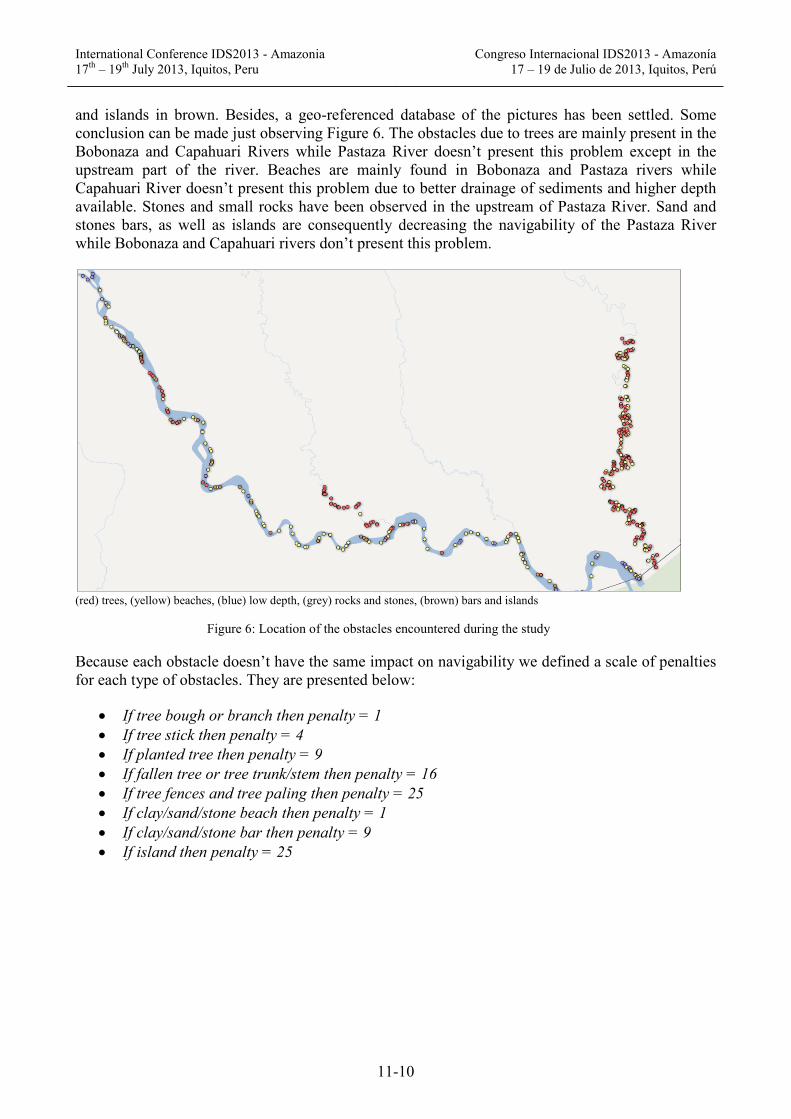
The locations of each type of obstacles can be observed on Figure 6 where obstacles related to trees are showed in red, beaches in yellow, low depth in blue, rocks and stones in grey and finally bars
International Conference IDS2013 - Amazonia 17th – 19th July 2013, Iquitos, Peru
Congreso Internacional IDS2013 - Amazonía 17 – 19 de Julio de 2013, Iquitos, Perú
11-10
and islands in brown. Besides, a geo-referenced database of the pictures has been settled. Some conclusion can be made just observing Figure 6. The obstacles due to trees are mainly present in the Bobonaza and Capahuari Rivers while Pastaza River doesn’t present this problem except in the upstream part of the river. Beaches are mainly found in Bobonaza and Pastaza rivers while Capahuari River doesn’t present this problem due to better drainage of sediments and higher depth available. Stones and small rocks have been observed in the upstream of Pastaza River. Sand and stones bars, as well as islands are consequently decreasing the navigability of the Pastaza River while Bobonaza and Capahuari rivers don’t present this problem.
(red) trees, (yellow) beaches, (blue) low depth, (grey) rocks and stones, (brown) bars and islands
Figure 6: Location of the obstacles encountered during the study
Because each obstacle doesn’t have the same impact on navigability we defined a scale of penalties for each type of obstacles. They are presented below:
• If tree bough or branch then penalty = 1 • If tree stick then penalty = 4 • If planted tree then penalty = 9 • If fallen tree or tree trunk/stem then penalty = 16 • If tree fences and tree paling then penalty = 25 • If clay/sand/stone beach then penalty = 1 • If clay/sand/stone bar then penalty = 9 • If island then penalty = 25
International Conference IDS2013 - Amazonia 17th – 19th July 2013, Iquitos, Peru
Congreso Internacional IDS2013 - Amazonía 17 – 19 de Julio de 2013, Iquitos, Perú
11-11
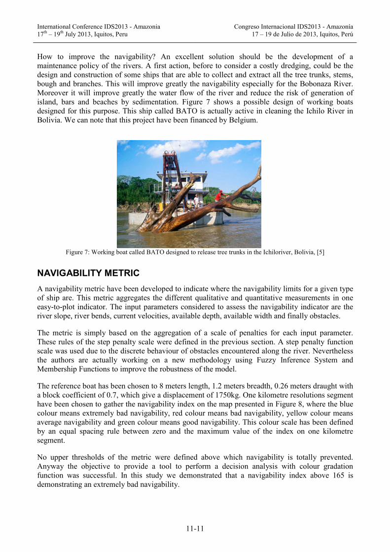
How to improve the navigability? An excellent solution should be the development of a maintenance policy of the rivers. A first action, before to consider a costly dredging, could be the design and construction of some ships that are able to collect and extract all the tree trunks, stems, bough and branches. This will improve greatly the navigability especially for the Bobonaza River. Moreover it will improve greatly the water flow of the river and reduce the risk of generation of island, bars and beaches by sedimentation. Figure 7 shows a possible design of working boats designed for this purpose. This ship called BATO is actually active in cleaning the Ichilo River in Bolivia. We can note that this project have been financed by Belgium.
Figure 7: Working boat called BATO designed to release tree trunks in the Ichiloriver, Bolivia, [5]
NAVIGABILITY METRIC A navigability metric have been developed to indicate where the navigability limits for a given type of ship are. This metric aggregates the different qualitative and quantitative measurements in one easy-to-plot indicator. The input parameters considered to assess the navigability indicator are the river slope, river bends, current velocities, available depth, available width and finally obstacles.
The metric is simply based on the aggregation of a scale of penalties for each input parameter. These rules of the step penalty scale were defined in the previous section. A step penalty function scale was used due to the discrete behaviour of obstacles encountered along the river. Nevertheless the authors are actually working on a new methodology using Fuzzy Inference System and Membership Functions to improve the robustness of the model.
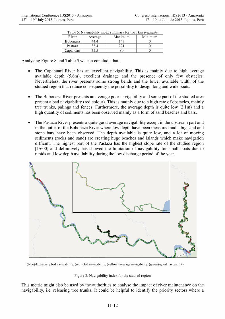
The reference boat has been chosen to 8 meters length, 1.2 meters breadth, 0.26 meters draught with a block coefficient of 0.7, which give a displacement of 1750kg. One kilometre resolutions segment have been chosen to gather the navigability index on the map presented in Figure 8, where the blue colour means extremely bad navigability, red colour means bad navigability, yellow colour means average navigability and green colour means good navigability. This colour scale has been defined by an equal spacing rule between zero and the maximum value of the index on one kilometre segment.
No upper thresholds of the metric were defined above which navigability is totally prevented. Anyway the objective to provide a tool to perform a decision analysis with colour gradation function was successful. In this study we demonstrated that a navigability index above 165 is demonstrating an extremely bad navigability.
International Conference IDS2013 - Amazonia 17th – 19th July 2013, Iquitos, Peru
Congreso Internacional IDS2013 - Amazonía 17 – 19 de Julio de 2013, Iquitos, Perú
11-12
Table 5: Navigability index summary for the 1km segments River Average Maximum Minimum
Bobonaza 44.4 147 0 Pastaza 33.4 221 0
Capahuari 35.5 80 0 Analysing Figure 8 and Table 5 we can conclude that:
• The Capahuari River has an excellent navigability. This is mainly due to high average available depth (5.6m), excellent drainage and the presence of only few obstacles. Nevertheless, the river presents some strong bends and the lower available width of the studied region that reduce consequently the possibility to design long and wide boats.
• The Bobonaza River presents an average poor navigability and some part of the studied area present a bad navigability (red colour). This is mainly due to a high rate of obstacles, mainly tree trunks, palings and fences. Furthermore, the average depth is quite low (2.1m) and a high quantity of sediments has been observed mainly as a form of sand beaches and bars.
• The Pastaza River presents a quite good average navigability except in the upstream part and in the outlet of the Bobonaza River where low depth have been measured and a big sand and stone bars have been observed. The depth available is quite low, and a lot of moving sediments (rocks and sand) are creating huge beaches and islands which make navigation difficult. The highest part of the Pastaza has the highest slope rate of the studied region [1/600] and definitively has showed the limitation of navigability for small boats due to rapids and low depth availability during the low discharge period of the year.
(blue)-Extremely bad navigability, (red)-Bad navigability, (yellow)-average navigability, (green)-good navigability
Figure 8: Navigability index for the studied region
This metric might also be used by the authorities to analyse the impact of river maintenance on the navigability, i.e. releasing tree trunks. It could be helpful to identify the priority sectors where a

International Conference IDS2013 - Amazonia 17th – 19th July 2013, Iquitos, Peru
Congreso Internacional IDS2013 - Amazonía 17 – 19 de Julio de 2013, Iquitos, Perú
11-13
cleaning of the river bed and bars is required. In that manner it will be faster and will increase the navigability of the river with a lower investment.
CONCLUSIONS The navigability of Bobonaza River is quite bad due to a high number of obstacles such as beaches, islands, tree trunks, paling and fences with some spots of low depths available, i.e. sometimes it was necessary to raise-up the propeller to pass over underwater tree trunks. Moreover the river presents sharp bends that reduce the possibility to navigate with long boats. The Bobonaza River presents an average depth of 2.1 meters, with a minimum measured of 1 meter. The maximum current measured is about 1.8 knots while the average current is about 1 knot.
Comparing to Bobonaza, Capahuari Rivers present highest depth available but lower width. This River has also sharp bends that reduce significantly the maximum allowable length of the boats. Nevertheless for small boats the navigability is excellent due to the highest depth available and the lower rate of obstacles found in the river channels and bars. The Capahuari River presents an average depth of 5.6 meters, with minimum measured of 3.4 meters. The maximum current measured is about 1 knot while the average current is about 0.6 knots.
The Pastaza River presents a quite good average navigability except in the upstream part, close to Chapracocha community and in the outlet of the Bobonaza River, close to Ishpingo Nuevo, where low depths have been measured and big sand and stone bars were observed. The upstream part of the Pastaza River has the highest slope rate of the studied region [1/600] and definitively has showed the limitation of navigability for small boats due to rapids and low depth availability during the low discharge period of the year. The Pastaza River presents an average depth of 3 meters, with minimum measured of less than 20 centimetres. The maximum current measured is about 3 knots while the average current is about 1.8 knots.
The outcome of this paper shows that the dimensions of the ship to be designed must be inferior to about 3.5 to 4 meter breadth, 0.3 meter draught (if the minimum depth considered is about 0.4 meters) and 5 to 7.5 meters length. These limits should be seen as a guideline for design but not as strong constraints.
REFERENCES [1] Brolsma J.U. and Roelse K., 2011, Waterway Guideline, RWS Centre for Transport and Navigation Desk,
Netherlands, ISBN 9789036900690
[2] Fraenkel P.M. et al.,1997,Approach Channels – A Guide for Design, Final report of the joint Working Group PIANC and IAPH, in cooperation with IMPA and IALA, Belgium, ISBN 2872230874
[3] Dominguez C., 2004, Issues of Local and Global Use of Water from the Amazon, Chapter 5 - The Importance Of Rivers For The Transportation System Of The Amazon, ISBN 9290890762
[4] Farr, T.G. et al., 2000, The Shuttle Radar Topography Mission (SRTM)
[5] SEMANA, Servicio De Mejoramiento De La Navegación Amazónica, Bolivia, http://www.semena.gob.bo
[6] McCartney, B., 2005, Ship Channel Design and Operation, ASCE manuals and reports on engineering practice, n°107, ISBN 0784407703
[7] Julien, P. Y., 2002, River Mechanics, Cambridge university press, ISBN 0521562848
[8] http://www.geoportaligm.gob.ec
[9] http://www.aquawatt.at
[10] http://www.elcomotoryachts.com/