a plan to use continuously operating gps … harris-galveston coastal subsidence district (hgcsd)...
TRANSCRIPT

A PLAN TO USE CONTINUOUSLY OPERATING GPS STATIONS TO MONITOR SUBSIDENCE IN THE HARRIS-GALVESTON COASTAL SUBSIDENCE DISTRICT RONALD J. NEIGHBORS, HARRIS-GALVESTON COASTAL SUBSIDENCE DISTRICT
GILBERT J. MITCHELL, NATIONAL GEODETIC SURVEY INTRODUCTION The Harris-Galveston Coastal Subsidence District (HGCSD) and the National Geodetic Survey (NGS) have signed a cooperative agreement to jointly pursue improved methods of monitoring land subsidence in the Houston Metropolitan area. The agreement seeks an unprecedented 1-centimeter accuracy in determination of rates of land subsidence. The plan developed as a result of the agreement, details the use of modern technology such as the Global Positioning System (GPS) high speed computers, sophisticated software, and electronic communications. A major objective of the planned project is to foster the development and use of high level technology in the public sector and the sharing of that technology with others. HGCSD, an agency created by the Texas State legislature to monitor subsidence in Harris and Galveston Counties, and NGS, a small agency in the U.S. Department of Commerce (NGS’ organizational hierarch is : U.S. Department of Commerce, NOAA-National Oceanic and Atmospheric Administration, NOS-National Ocean Service, C&GS-Coast and Geodetic Survey, NGS), have a long history of beneficial joint activity in the study of land subsidence. HGCSD is a local government agency created in 1975 by the 64th Texas legislature to regulate the withdrawal of groundwater within Harris and Galveston Counties and, in the words of the legislation, “... for the purpose of ending subsidence which contributes to or precipitates flooding, inundation, or overflow of any area within the district, including, without limitation, rising waters resulting from storms or hurricanes.” HGCSD is governed by a 17-member Board of Directors appointed by local government officials. In order to drill or operated a well in Harris or Galveston Counties, a permit must be obtained from HGCSD. HGCSD is self-supporting, raising revenues through the permitting of water wells. A fee for the use of the water well is paid by the permitter based on the annual allocation of groundwater authorized by the Board. Subsidence, i.e., sinking of the land surface, is frequently related to the withdrawal of underground water, oil, and other fluids. Subsidence in the coastal areas of Louisiana may also

be related to the composition of underlying geologic structures. In the Harris-Galveston region of Texas, subsidence poses the greatest threat in the coastal areas susceptible to flooding due to high tides, heavy rainfall, and hurricane storm surge. We all remember the recent visit of Hurricane Andrew, as well as past members of Andrew’s family. Those of you who live or work in the New Orleans area, unfortunately, all too familiar with its susceptibility to flooding from heavy rainfall and the potentially devastating effects of hurricanes. The recognition of problems associated with ground subsidence in the region dates back to the
1950s and the beginning of rapid development of the Harris-Galveston area. Water requirements for this rapid growth were met tapping into the two fresh water aquifers that lie beneath the Harris-Galveston area. However, the area soon began to see dramatic ground subsidence and, in the 1960s, community and business leaders began seeking solutions to the problems. It was not until 1975, however, that HGCSD was created. By the time of HGCSD’s creation, areas around Clear Lake, including the Johnson Space Center, had subsided 4 feet and nearly all of the two-county area had sunk at least 1 foot. Subsidence of the Harris-Galveston and adjacent areas is really a national problem. While it is devastating to local residents caught in the consequences of flooding in subsided areas, it is a national problem in that hundreds of thousands of people live and work in the are, producing goods and services for the entire nation. The multi-million Ship Channel provide the economic base which the Harris-Galveston area was built and still depends. These industrial complexes require waterfront access and must be protected. NGS has a long history of concern about subsidence in the Harris–Galveston area. As figure 2 indicated, NGS has been monitoring Harris–Galveston subsidence for many years.

HGCSD had developed several cooperative and partnership approaches in meeting its responsibilities, including agreements with other Federal, state, and local agencies. Another major Federal agency that has cooperated very effectively with HGCSD is the U.S. Geological Survey (USGS), which assisted the District in the development and deployment of six subsidence monitoring extensometers. These extensomters have played a significant role in the monitoring of subsidence in the District. Figure 3 is a diagram of a typical bore hole extensometer, the type most prevalent in the District.


In addition to extensometer activity, USGS has shared its technical expertise and provided assistance to the District in the development of water quality and quantity data. USGS personnel have also offered to assist HGCSD and NGS in the development of the new approach to subsidence monitoring described in this document. In addition to NGS and USGS, the District has forged partnerships of limited extent and duration with a number of other Federal, state, and local agencies, including the Texas Water Board, Texas Department of Transportation, Metro, Houston Power and Light, National Aeronautical and Space Administration, Federal Emergency Management Agency, and the U.S. Department of Energy. NGS and HGCSD have cooperated in subsidence monitoring since the District was established in 1975. NGS had completed leveling surveys in 1963 and 1973 prior to the existence of the District. Cooperatively funded surveys were completed in 1976, 1978, and 1983. As reported in the 1989 NOAA Technical Report NOS 131 NGS 44 Subsidence at Houston, Texas 1973-87 by Holdahl, Holzchuh, and Zilkoski: “Balazs (1980) compared level survey results from 1963, 1973, 1976 and 1978. A significant conclusion in that report was that subsidence rates between 1973 and 1978 had slowed by 25 percent on the east side of Houston where maximum change had occurred for the prior period 1963-73. The lowering of subsidence rates in that region was attributed to reduced withdrawal of water for industrial use. Increasing amounts of surface water brought in by newly constructed canal systems have continued to replace water previously taken form underground.”
SURVEYING AND MAPPING • DECEMBER 1981 -SOURCE

Holdahl et al. (1989) also noted “During the period from 1978 to present (1978), groundwater withdrawals continued to decrease on the east side of Houston due to the continued regulation of groundwater and the availability of service water to replace it. The area to the west of Houston, however, was continuing a period of rapid growth which was supported solely by groundwater withdrawals. The means to supply surface water to west Houston have not yet been implemented. After a partial releveling of the Houston network in 1983, Zilkoski (1984) also calculated a decrease in subsidence east of Houston (328.6 mm between Houston and Addicks) since 1978. This result seemed to conform well with the pumping results.” The report also notes “The 1973 and 1978 surveys were undoubtedly biased by magnetic errors that were not known to exist in 1978.” The 1978 survey was one of the most comprehensive areal surveys completed up to that time. Not only was the entire Houston Metropolitan area leveled using eh latest instruments and

procedures, but the surveys were held to very tight specifications with relevelings as necessary to meet allowable tolerances. This was done to assure the most accurate base data for future remeasurements and monitoring of subsidence. In addition to the leveling, there were also more than 80 points common to the level network that were observed using the most accurate Global Positioning System (GPS) receivers available. The addition of GPS points was in preparation for the eventual use of GPS observations to measure and predict subsidence. In addition, the precise leveling operation undertaken by NGS in 1987 required all NGS field capability for several months. The size of NGS’ field component was already in a downward spiral that has continued to date. The GPS observations were looked on as a sort of “insurance,” since both NGS and HGCSD had agreed to continue future cooperation in the subsidence monitoring effort.
Figure 6 – 1987 GPS Survey Sites Source: NOAA Tech. Rpt 131


HGCSD had a legislative mandate from the Texas legislature and a duty to their clients to be accurate in th analysis of the subsidence rates. NGS has a continuing obligation to the integrity of National Geodetic Reference System (NGRS) and a interest in developing the most efficient manner of measuring subsidence throughout the nation. In addition, HGCSD had taken on other responsibilities, including a contractual arrangement with the Fort Bend Subsidence District (FBSD). HGCSD had agreed to provide support and assistance to this new board, bringing their experience and professional knowledge to assist them. FBSD had to operate with a large handicap, in that there are no extensometers presently available in the district to monitor subsidence on a continuing basis. Therefore, NGS and HGCSD are faced with the following tasks: 1. Meeting Their Respective Continuing Obligations Under Changing Technical Conditions,
i.e., HGCSD to Faithfully Monitor Subsidence in Their Area of Responsibility and NGS to Validate NGRS Coordinate Values. 2. Meeting the Stated Objectives on Their Continuing Cooperative Agreement: For HGCSD
This Would Receive Funding fo Releveling Costs Approaching $1.5 Million, however NGS Has Insufficient Field Personnel to Accomplish the Task! 3. Providing Current Information On Subsidence Rates in New Areas of Interest Without Extensive New Leveling! (Underground Water Withdrawal Patterns Have Changed Dramatically Over the Past 10 Years in the Houston Metropolitan Area)

4. Providing Current information on Subsidence Rates to the Coverage Area of the Fort
Bend Subsidence District Where No Extensometers Exist (Estimated Cost of Extensometer Installation Is At Least $500,000 Each). 5. Providing an Approach That Would Be Useful to Others Facing Subsidence Problems: A
Way to Make Technology Transfer Happen. Several meetings have been held over the past several months between key HGCSD and NGS officials to discuss possible approaches to meeting the problem facing both agencies. These meetings have since been broadened to include USGS and other interested parties. There was considerable interest by both HGCSD and NGS in following up on the possible use of GPS that had been initiated in 1987. A number of factors bode well for the initiation of such a project: 1. The GPS satellite configuration is near completion, thereby providing almost-the-clock coverage for observations; 2. Computers of very small physical size now have tremendous computational power; 3. GPS Surveying has dramatically improved in accuracy (and receivers have become much smaller in size and weight); 4. Similarly, software used for the reduction of GPS observations and elimination of errors
such as cycle slips has been greatly improved; 5. The extensometers have proven over time to be like “super” bench marks, i.e., they are
very stable; 6. There is growing interest throughout the nation in the development of GPS base stations (continuously operating reference stations), hence other organizations are likely to contribute and/or participate in a project of this nature. The operations approach in the initial stages is based on the known stability of the extensometers, which are to be developed as continuously operating GPS stations in the first phase of the project. The following diagram shows the location of the subsidence monitoring extensometers that will be used in this project and initial locations of additional GPS stations to be measured with “portable permanent” facilities.

The small house located at the extensometers, shown in the photograph labeled figure 8 will be replaced with larger prefabricated concrete structures such as that shown in figure 9.

The larger concrete structures will also allow installation of air conditioning and computer and peripheral electronic gear for data transmission. At least three of the six extensometers will be outfitted with the special prefabricated concrete houses in the initial phase. These sites are 10 to
20 miles apart. It is anticipated that one of these sites will be used in testing the feasibility of the continuously operating reference station concept, however further development and appropriate cooperating mechanisms are not yet in place. Operation of the GPS receivers at the three extensometers sites is expected to continue for 1 year. Future operation of these facilities will be decided after these initial tests are completed.
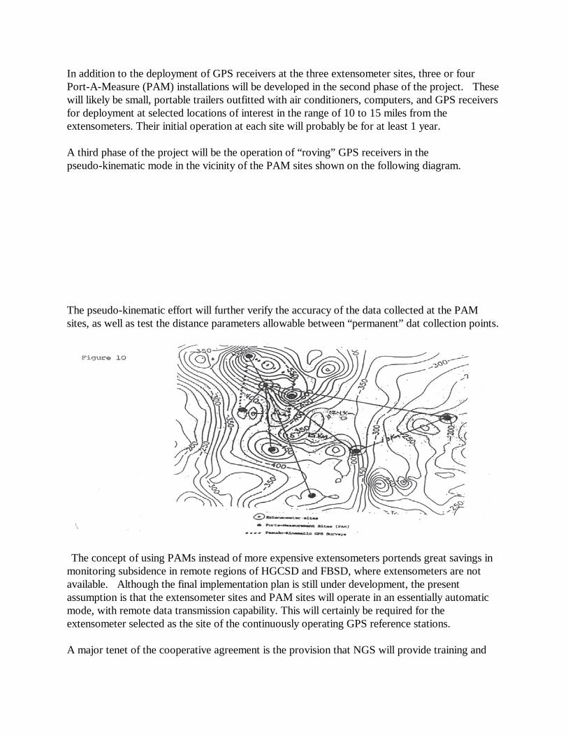
In addition to the deployment of GPS receivers at the three extensometer sites, three or four Port-A-Measure (PAM) installations will be developed in the second phase of the project. These will likely be small, portable trailers outfitted with air conditioners, computers, and GPS receivers for deployment at selected locations of interest in the range of 10 to 15 miles from the extensometers. Their initial operation at each site will probably be for at least 1 year. A third phase of the project will be the operation of “roving” GPS receivers in the pseudo-kinematic mode in the vicinity of the PAM sites shown on the following diagram. The pseudo-kinematic effort will further verify the accuracy of the data collected at the PAM sites, as well as test the distance parameters allowable between “permanent” dat collection points.
The concept of using PAMs instead of more expensive extensometers portends great savings in monitoring subsidence in remote regions of HGCSD and FBSD, where extensometers are not available. Although the final implementation plan is still under development, the present assumption is that the extensometer sites and PAM sites will operate in an essentially automatic mode, with remote data transmission capability. This will certainly be required for the extensometer selected as the site of the continuously operating GPS reference stations. A major tenet of the cooperative agreement is the provision that NGS will provide training and

assistance to HGCSD personnel or designees in the analysis of the subsidence data so that HGCSD can develop an operational capability. NGS will remain “on call” to assist after the development phase of the project is completed. SUMMARY HGCSD and NGS are embarking on a “leap of faith” in their desire to stretch GPS technology to its limits. This project is being undertaken not only to meet the immediate needs of the agencies involved, but also as an outreach in the struggle to see more cooperation between public agencies. Costs and expertise are being shared by HGCSD and NGS to move forward in the analysis and monitoring of a common problem, land subsidence. This problem affects large areas of the United States and other nations of the world. The project utilizes GPS in several observational techniques, from pseudo-kinematic in areas of known subsidence, to the use of static observations at “stable” extensometer sites, to static observations at specially designed portable observing stations in a variety of locations. It will feature testing of various electronic methods of transmitting GPS observations from the acquisition point to a central location for processing and analysis. The project will seek to determine elevation or height differences over time at selected points in the most accurate manner, approaching 1 centimeter accuracy. Other agencies will be invited to participate in this project. The results of this unique project will be readily available to all interested users.