a proposed orphanage and retreat house 2014
DESCRIPTION
A research made by students as requirement for AR 327 - Site Planning. It a study beneficial for people in need of finding a suitable space for their project.TRANSCRIPT

Ateneo de Davao University
School of Engineering and Architecture
Emilio Jacinto Street, Davao City
PROJECT 1 - SITE ANALYSIS OF AN ORPHANAGE AND RETREAT HOUSE
In Partial Fulfillment of the Requirements for the Degree of Bachelor of Science in Architecture
AR 327 – Site Planning and Landscape Architecture
Submitted to:
Ar. Jasmin D. Conquilla
Submitted by:
Avena, Dayanara
Cabarroguis, Alexa
Mendiola, Paola
Yee, Via

ACKNOWLEDGEMENT
We would like to express our gratitude to our parents for supporting us
in the process of completing of our project and for taking us to the site on
our first visit.
We would also like to express our sincere gratitude and appreciation to
our dearest Ar. Jasmine Conquilla for mentoring and guiding us all through
out the process and for allowing us to allot some time to visit our site and
gather information for the completion of our requirement.

TABLE OF CONTENTS
TITLE PAGE………………………………………………………………………….….1
ACKNOWLEDGEMENT……………………………………………………………..…2
INTRODUCTION…………...………………………………..………………………....4
EXECUTIVE SUMMARY…………………………………..…………………………..5
SITE 1………………………………………………………………………..……..……..7
LOCATION………………………………………………………………..….…..7
ORIENTATION……………………………………………………………...…..8
HISTORICAL BACKGROUND…………………………………………..…...8
SOIL TYPE………………………………………………………………...….....9
SLOPE……………………………………………………………………..……..9
VEGETATION…………………………………………………………….....…10
HYDROLOGY……………………………………………………………....…..11
SINKHOLES……………………………………………………………..….….11
TRANSPORTATION…………………………………………………..…....…11
HEIRARCHY OF ROADS……………………………………………………..11
NEIGHBORHOOD CONTENT…………………………………………….…12
MANMADE FEATURES………………………………………………….…..13
CLIMATIC CONDITIONS…………………………………………….……...14
LEGALITIES/PARCEL OF LAND…………………………………………..14

SITE 2……………………………………………………………………....……..……15
LOCATION………………………………………………………………….….15
ORIENTATION………………………………………………………….....….15
HISTORICAL BACKGROUND…………………………………………..….15
SOIL TYPE……………………………………………………………….....…16
SLOPE……………………………………………………………………....….16
VEGETATION…………………………………………………………....……16
HYDROLOGY.................................................................................17
SINKHOLES…………………………………………………………….……..17
TRANSPORTATION…………………………………………………….…….18
MANMADE CONDITIONS……………………………………………..……18
UTILITIES AND FACILITIES ………………………………………………19
CLIMATIC CONDITIONS………………………………………………......19
LEGALITIES/PARCEL OF LAND……………………………………....…19
HIERARCHY OF ROADS …………………………………………….….....20
NEIGHBORHOOD CONTENT……………………………………………...21
COMPARATIVE ANALYSIS…………………………………………………………22
RECOMMENDATION/CONCLUSION………………………………………….…23
SITE PERSPECTIVE.................................................................................24

INTRODUCTION
In this study the readers will be able to thoroughly investigate the given area. The
researchers have provided various information about the lot that would be essential in
the study. This includes the topographical, geographical and physical features of the
site. Some of the specific factors that should be considered are the zoning,
neighborhood content, history, legal elements, circulation, natural features and man-
made features available in the site.
This paper will focus on the characteristics of two different areas located in
opposite direction. At the end of the study, the researchers' aim is to evaluate which
site is most effective and appropriate for the proposed project. Through this, proper site
planning will be implemented.

EXECUTIVE SUMMARY
The sole purpose of documenting the site analysis investigation is to provide
proof and reason to support why our chosen site is the most appropriate for our
orphanage and retreat house. Through this, we will be able to gather information that
will help our study and future possible projects. Collecting data will help us improve and
gain knowledge about our site which will therefore be our basis and reference if our site
is suitable for this project or not.
Our site is a huge lot which is next to the main road (highway) which makes it
suitable because it is highly accessible and convenient. Although it may be a busy and
polluted area, we took into consideration the size of the lot and made it big enough that
the structures have large setbacks from the highway so it could still maintain its peace
and harmony. We also considered the natural boundaries (trees, plants) and
landscaping which could be a form of noise and pollution blocker and somehow isolate
the site from the busy street. We would also like to emphasize that only the front part of
the site is busy. At the rear part of the site is a residential zone therefore there is less
noise and distractions from the city streets.

SITE 1
I. Location
Picture 1.0 Satellite view of the site
Site 1 is located at
Carmelite Monastery
along J.P. Laurel Ave.

Picture 1.1 Map view of the site
II. Orientation
Picture 2.0 Vicinity map
with sun and wind path
direction
III. Historical Background
The Carmelite monastery was a tribute to St.
Theresa of Jesus de Avila. Shewas a prominent
Spanish mystic, Roman Catholicsaint,
Carmelitenun, an author of the Counter
Reformation and theologian of contemplative life
through mental prayer. She was a reformer of
the Carmelite Order and is considered to be a
founder of the Discalced Carmelites along with
John of the Cross.
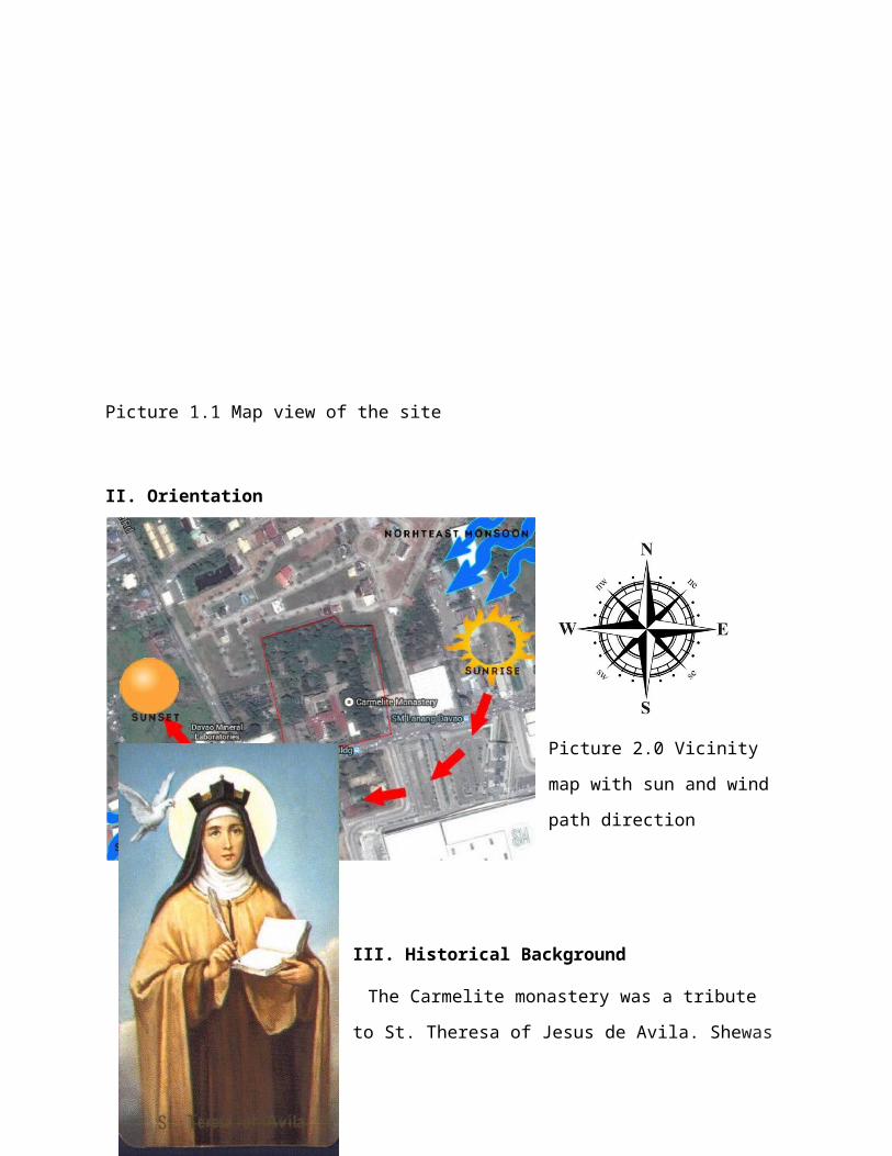
Picture 3.0 St. Theresa of Jesus de Avila
IV. Soil Type
Picture 5.0 Clay and Loam soil
The soil type present in the area is
mostly clay, such soil are suitable for
planting trees and shrubs. Based on
the topographical map we have, the
site mountainous.
Picture 5.1 Topographical map of site
V. Slope
The site has little slope that it is almost plain. Since it is located along highways and big establishments, the land has already been paved and developed.

VI. Vegetation
There are a lot of trees and landscaping in the area. There are trees such as Indian tree, palm trees, and pine trees. There are also shrubs and flowering plants.
VII. Hydrology
There are no major water features found in the site. It is not prone to
flooding.
VIII. Sinkholes
Picture 6.0 Indian treesPicture 6.2 Palm trees and shrubs
Picture 6.3 Pine tree

There are no sinkholes found in the site and it is not prone to
corrosion. There are also no mining activities that occurred in the past. The
site is just plane.
IX. Transportation
The site is accessible to almost all types
of vehicles. We may ride a jeepney, taxi, or
private vehicle since it is located next to the
major road. From the Ateneo de Davao College
going to Carmelite, it will take us 15-20
minutes depending on the traffic. We visited
the site three times and we observed and
took a few notes about it. We used a
private vehicle on our first visit and a jeepney
on our succeeding visits going to the site
Picture 9.1
Jeepneys along the main road
X. Hierarchy of roads
Vehicles can pass
through the J.P laurel
road, which is the main
road since the site is just
along it. There are also 2
main roads near the site,
which is the Carmelite
road and Mamay road.
Picture 9.0 Private cars at the site

Picture 10.0 Vicinity map with hierarchy of roads
XI. Neighborhood Content/Context
Picture 11.0 SM Lanang
Picture 11.1 Commercial Buildings
Picture 11.2 Damosa Gateway

The dominant landmarks near the site are commercial buildings like
SM Lanang just in front the site, There are also commercial buildings and
Damosa gateway with an approximate of 250-300 meters away. The site is
accessible to the city proper through the main road which is JP Laurel Ave.
The zoning is General Institution since there are also schools and hospitals
near the site.
XII. Man made Features
There are existing buildings in the
site, that is the church and the
office. There are also man-made
water features and grottos.
Picture 12.0 Carmelite church
Picture 12.2 Grotto
Picture 12.1 Office building
XIII. Utilities and Facilities
The Davao Light supplies power to the site and
its surrounding areas while the Davao City
Picture 13.0 Electrical line

Water District provides water. Telecommunication lines are provided by
Philippine Long Distance Telecommunications and cellular phone coverage
provided by Globe, Smart, Sun, TnT and Touch Mobile also Internet
connection is available. All signals are strong in the vicinity.
XIV. Climatic Conditions
Davao City enjoys a mild tropical climate. Compared with other parts
of the Philippines in which there is a district hot and wet season. It enjoys the
privilege of a climate where the days are always sunshiny and mild followed
by nights of rain. The city is outside the typhoon belt and lacks major
seasonal variations. The predominant wind direction is northward from the
Davao Gulf where the cooler air of the sea replaces the warm air mass over
the city. Surrounding mountain chains protect the city effectively from
strong wind
XV. Legalities/Parcel of Land
Ownership
Legal documents

SITE 2
I. Location
The second site is located at Toril, BaranggayDaliao. The lot is found in the outskirts of a peaceful community. It is surrounded by government establishments and beach resorts since it is near Davao gulf.
We have chosen this site because we think than an ideal Orphanage and Resort House should be solemn and away from the noise of the city. Toril is also now a fast developing district here in Davao, this new proposed project could also help Toril to be more locally competitive.
II. Orientation
The orientation of our chosen site is facing toward the beach. The cool breeze from the sea permits cool air to just circulate around the area, so it's not that humid during noontime.
III. Historical Background
The site we have chosen has an interesting background. Way back during the Presidential
Picture 1.0 Location of Site 2
Picture 1.1-Paved Area of Site
Picture 2.0-Paved Area of Site
Picture 3.0 President Ferdinand Marcos

term of Ferdinand Marcos, this area was used as a plantation of Abaca. This was mostly the source of livelihood of the people living near the neighborhood, since during this period the use and export of abaca is prevalent in the trade of the industry in the Philippines.
IV. Soil Type
The soil present in the area is very good for planting and establishment of massive buildings. They have loam and sand as their soil types. Since the present site now is flat and paved, any contours and difference in height of irregularities cannot be
determined around the area. But based on the topographical map we have, Baranggay Dalao is not mountainous.
There is just little deformation in the elevation of the land.
V. Slope
The land in the site has also a little slope. Since it is near the shoreline, the land is sloping downwards to the sea. But in the site itself, the land is paved and developed.
VI. Vegetation
One of the vegetation that could be found in the area is the banana tree. It is an edible fruit, botanically a berry,
produced by several kinds of large herbaceous flowering plants in the genus Musa. There are various other
Picture 4.1 Topographic Map of TorilPicture 4.0 Soil found in the site
Picture 6.2 Ipil-Ipil Tree
Picture 6.1 Banana Tree

types of trees present in the area. There are scattered shrubs of plants and long stalk of grasses.
VII. Hydrology
The existing body of water near the area is the Davao Gulf. It is 180-200 meters away from the seashore. Mostly the source of water of the people living in the neighborhood is from water pumps provided by the government. According to the residents, flooding is not a problem in the area because of the bountiful presence of vegetation in the area.
There are also resorts near the area like the Vales Resort. As part of the livelihood of the residents, there is also a Fish Port Complex near the site.
VIII. Sinkhole
According to the residents and based in our survey of the area there are no
existing sink holes or mining history in the site. Neither do landslides occur because it is in the lowlands. The residents try to protect this area because of its virginity and also there are no investors who would like to improve the site.
Figure 7.0 Image of Davao Fish Port
Picture 7.1 Image of Vales Beach Resort

IX. Transportation
We went to the site by riding a jeepney. From Ateneo de Davao University, it would take at least 40 minutes to 1 hour travel time going to Toril depending on the flow of traffic. Going inside the site, we rode a
tricyle which took us around 5-10 minutes.
In the given span of one month, we went to the site a total of seven times. We went there on different kind of weather and time so that we could gather various types of information.
X. Man-made Features
Pave cement, manhole and barangay hall are some features located on the
site. The manhole allows easy access to underground piping which is used
for storm water access. There are also canals in the areas which are still
being used today for navigation, land drainage and urban water supply.
Barangay Hall
Picture 9.0 Jeepneys available in the area
Picture 9.1 Tricyclearound the area

Existing drainage system in the site
XI. Utilities and Facilities
The site’s power is being provided by the Davao City Light and Power
Company (DPLC). Water is being supplied by the Davao Water District
(DCWD) within the site and its neighboring establishments.
Telecommunication companies such as PLDT, Globe, Smart and Sun are also
present within the area
XII. Climatic Conditions
Davao city has a district hot and wet season. It is designated by a uniform
distribution of humidity, air pressure and rainfall. The city is also a typhoon-
free which enclosing a range of mountains that protects the city from strong
winds and a balmy tropical climate where the days are always shiny and
mild followed by the nights of rain.
XIII. Legalities/ Parcel of Land

This site is legally owned by a private company of the National Development Company (NDC) and is acknowledged and registered in the Property Identification map of the Tax Mapping Division of the City Assessor's Office.
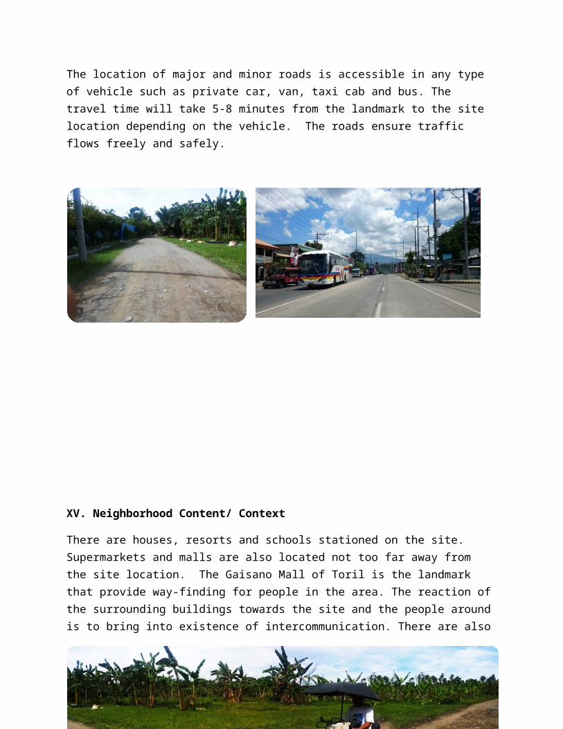
XIV. Hierarchy of Roads
The location of major and minor roads is accessible in any type of vehicle such as private car, van, taxi cab and bus. The travel time will take 5-8 minutes from the landmark to the site location depending on the vehicle. The roads ensure traffic flows freely and safely.
XV. Neighborhood Content/ Context

There are houses, resorts and schools stationed on the site. Supermarkets and malls are also located not too far away from the site location. The Gaisano Mall of Toril is the landmark that provide way-finding for people in the area. The reaction of the surrounding buildings towards the site and the people around is to bring into existence of intercommunication. There are also street lights positioned along the road for nighttime visibility security and safety.

The Site Location
Gaisano Mall of Toril
COMPARATIVE ANALYSIS
LEGEND:
DESIRABLE
MODERATE
UNDESIRABLE
SITE CRITERIA SITE 1 SITE 2
Size of the lot
Proximity to future expansion of the community
Road access
Safety of roadways
Desirable neighborhood
Potential for Environmental hazard condition
Soil foundation conditions
Aesthetic value of the site
Noise/Air pollution
Availability of water/power/communication utilities
Ease of access to users
RECOMMENDATION/CONCLUSION
The researchers recommend the site 1 more than the site 2 because it is more accessible and has more landmarks. The site 2 is a good site for a retreat house since it is located farther from the city. But we think the site 1 could be a better site because in our own perspective people don't need to go far away just to find peace and a refreshing place to stay. The site 2 could be developed and be an effective orphanage and retreat house. It is also near establishments that could make the proposed project to be more effective.

"A PROPOSED

ORPHANAGE AND RETREAT HOUSE"
LEGEND:
1. Chapel
2. Orphanage House
3. Retreat House
4. Open Area and Garden
Site Perspective