a reassessment of the zuniga map and the old paradigm of the lost colony relocating on the...
TRANSCRIPT

A Reassessment of the Zuniga map and the old paradigm of the
Lost Colony relocating on the Chesapeake
Bay is tested
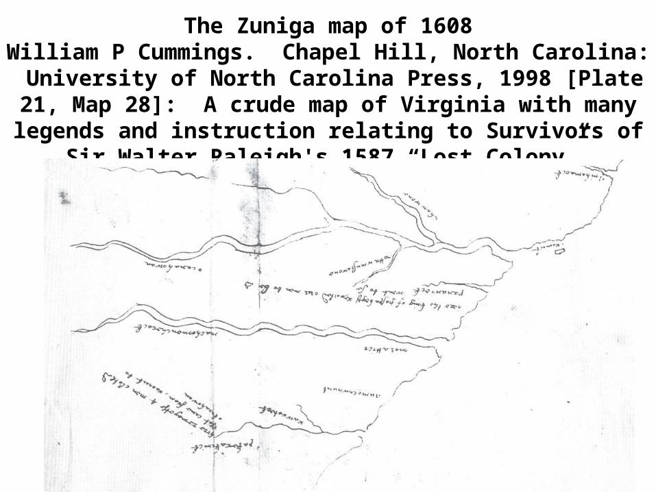
The Zuniga map of 1608William P Cummings. Chapel Hill, North Carolina: University
of North Carolina Press, 1998 [Plate 21, Map 28]: A crude map of Virginia with many legends and instruction relating to
Survivors of Sir Walter Raleigh's 1587 “Lost Colony”.
The next slide is a transliterated copy of the Zuniga map.
The Zuniga Map is one of only a few documents that have been recently found in
the Spanish archives. Many more documents relating to North American research may also
be there and not-yet-discovered

All of the notations on this map are information discovered from Jamestown about the Lost Colony of 1587, and are Indian Villages that
have never been located successfully on other maps

This is a Theodor DeBry version of John White’s map of 1585. It was published in 1588 and is turned with North orientation to the right. The three important villages relating to the Roanoke mystery are depicted with arrows. The colony merged with the Indians and many citations
as developed in this paper show the location of important Indian Villages

Mercator-Hondins Map 1606 (Cumming: [Plate 20, Map 26]) This map drawn two years before Jamestown was settled, but shows the same
villages

• Seventeen maps are referenced to in the addenda below and all irrefutably depict Panawiky, Coahohorn or Ritino, Kinic or Pakrawick and Carrawack or Carohch as depicted on the Zuniga Map. All of the maps are from William P. Cumming, “The Southeast Early Maps” third edition, revised and enlarged by Lewis De Vorsey, Jr. Chapel Hill, North Carolina; the University of North Carolina Press, 1998.)

The “Lost Colony” resettled on Chesapeake Bay
The old paradigm has little evidence to support it. Many new
reported citations and references, relating to the Lost Colony being located in North Carolina, have been recently
found and documented

• 1). John White in 1587: “Also he (John White) alleaged, that seing they • intended to remoue 50 miles further vp into the maine presently, • he (John White) being then absent, his stuff and goods, might be • both spoiled, and most of it pilfered away…” (Quinn 1955:533-• 534).• 2). John White in 1590: “…for at my coming away they were prepared to • remoue from Roanoke 50 miles into the maine” (Quinn 1955: 613)• 3). One of the weroances of Quiyoughcohannock (It was probably “Pepis-• cunimah [also called Pipsco] sent guides with an expedition to the • Chowanoke Indian Village to find Lost Colonist that they knew • where living there (Rountree1989:51, 295).• 4). Opechancanouh (Powhatans brother) while holding John Smith cap-• tive at Rasawrack told John Smith that there were people at the • Indian Village of “Ocanahohan” (Most likely on the Roanoke river • in North Carolina) who were wearing European clothing (Rountree • 1990: 37)• 5). “Machumps, a werrowance of the village of Pespehay told William • Strachey that at the towns of “Peccarecamek” (near the Coree Indi-• an Village which is a few miles west of Cedar Island North Caroli- • na) and “Ochanahoe” the people have built houses with stone walls • (on story above another), so taught them by those English who es-• caped the slaughter at “Roanok”. (Miller 2002: 250 [citing Strac-• key-History-1884:26]. There is much brass at “Pakerakanick” (Pos-• sibly in Pamlico County North Carolina) and “Ocanahowan” (Roa-• noke River North Carolina) the people breed up tame turkeys a-• bout their houses. At “Pakerakanick” they take aps from the moun• tans (copper).•

• 6). Wowinchopunk, the Paspahegh king gives a relation that the lost co- • lonists are well known at an Indian Village called Panawicke (pos-• sibly on the upper Pamlico River near Chocowinity North Carolina), • beyond Roonoke many clothed men who are appareled can be • found. Wowinchopunk agrees “to conduct two of our men to a • place called Panawicki (sic) (Miller 2000: 214, citing Smith True • Relation CR4).• 7).”Tackonekin a werraskoyack leader agrees to give John Smith two • guides and directions” of where to (---“search for the Lost company • of Sir Walter Rawly, (and where to find) silk grass” Michale Sickle-• more spent three months looking on the Chowan River where he • gave presents to the King of the Chowan Indians (John Smith “Pro-• ceedings : 87)• 8).Powhatan’s servant named Weinock told William Strachey “That hou-• ses are built like ours, which is a ten days’ march from Powhaten • (Miller 2002:255).• 9).The Zuniga Map: On September 10 1608 Phillip III (of Spain) received • Intelligence from the London spy network of Pedro de Zuniga (The • person is described by Zuniga as an Englishman-(probably Cap-• tain Francs Nelson). Contained in a packet from Zuniga is a tra-• cing of a map sent home to England from John Smith in Virginia. • This document gives intelligence that Panawicke (Possibly now lo-• cated on the upper Pamlico River near Chocowinity North Caro-• lina). Pakercanick (Possibly in Pamlico County North Carolina) • and Ohanhowan (Possibly on the Roanoke River) are all locations • where colonists from Roanoke Island are now residing with Indians • probably as captive slaves. [The original Zuniga map is in the Ar-• chivo General.• 10).James Sprunt reports, in 1664, that the Coree Indians from the • Cape Fear River report that the Lost Colony is living with the Hat-• teras Indians not far away.

The single-most important source to support
the Chesapeake Bay paradigm is found below and many problems with it have recently been discovered
Strachey reports about the 1587 Colony: [The Powhatton of Ro- anocke slaughtered the colony (Miller 200:250, 255, 258, at Ri- tino (The king Eyanoco, where all but seven were killed. Four men, two boys and a young maid who were sent to the Chowan to beat the said Kings copper]. Strachey thought this meant Po- cahontas’s father. Powhatan can be translated as priest. This possibly should be reconsidered as saying: “The priest of Roa- noke -----”, placing the attack in or near the settlement of Roa- noke Island or River. [This is the main source for the Chesa- peake Bay Paradign] Ritino is Coahohorn and on the Roanoke River and the king Eyanoco is the deadly enemy of Powhatan.

Studies in deed research and the migration of coastal Indians all support the North Carolina paradigm.
Of the one hundred surnames of Indians from the coast, forty-nine are on the roster of the Lost Colony of 1587


This land grant to Williams Elks (and the rest of the Hatteras Indians) in 1759, from the state of North Carolina, is from the Croatan Indian site in Buxton, listed here as "Indian
Town". It is from these documents that the movement of the Native Americans from Croatan to the west has been ascertained.
Published by The Roanoke Beacon, and can be visited @ (www.Lost-Colo-ny.com). Sixty-six people today with the last name of Elks live on Chicod creek (the location of our
proffered Panawicky-Chocowinity today). They are all descended from the Hatteras Indian Chief Samuel and William Elks which was ascertained with an in-depth genealogy
research project. The main proffered hypothesis is the colony assimilated with the Croatan.

The Alligator River depicted below is the area where the Croatan/Hatte-ras/Mattamuskeet Indians moved to after 1690. The
large landmass to the right is Beech-Land, called East Lake today. On the upper right of the photo is Roanoke Island. The Buck Ridge site is on the west side of the river, at the bottom, where it cuts to the west.
This is the location where the deed for Samuel Elks was found.

This grant is also for an Indian site and signed by another Indian named Samuel Elks. All of the Elks moved from the coast and settled in Chocowinity which is our proffered location of Panawicky. Indians would have moved to a
location they knew was friendly, another Indian village.

The migration before 1600 is shown in red, and the more gradual migration over 200 years is shown in blue. Additional upporting
genealogical and historical data for the latter migration has also been found The early migration began at three villages on Croatan Island, The Croatoan later occupied Dasemonkepeuc (Manns Harbor) after the Roanoke Indians abandoned it. They then moved to the Pamlico
after 1777 to Chicod creek or Panawicky as depicted on Zuniga.

Addenda• Maps studied documenting the locations of Panawicky, Pakrakwick (sic), Careohoch, and Ocanahonan . (The
following maps are taken from Willi-am P. Cumming, “The southeast Early Maps” third edition revised and enlarged by Lewis De Vorsey, Jr. Chapel Hill, North Carolina; the Univer-sity of North Carolina Press, 1998.)
• 1---John Speed. A New Description of Carolina, 1676. [Plate 4, Map 77] • Kinack (on Beard’s Creek) First map to list Machapungo Indians• 2---Robert Mordon, John Thorron and Phillip Lea. A New Map of Caroli-• na (A) Ca 1685. [Color Plate 6, Map 140] 1---Pantrooc (sic)• 3---Nicolas Sason D’Abbeville, Carte General de La Caroline, Ca 1696 (A) • [Plate 9, Map 120] 1---Ma(e)rpung (sic)• 4---Jacques Nicolas Bellín. La Caroline dans I’ Amerique Septentrional, • 1764 [A, Plate 21, Map 342] At Cape Hatteras “A Village of Indi-• ans”• 5---White-De Bry. Americae Pars, Nunc Virginia dicta, 1590 (A) [Plate 14, • Map 12] 1---Panauuaioc (sic), 2---Cwarrutoc (sic), 3---Tramans-• quecooc (sic)• 6---John White. Virginea Pars. 1585 (MS B.) [Plate 12, Map 8] 1---Tra-• mansquecooc, 2---Croatan• 7---Wright. A Chart of the World on Mercator & Projection, 1599 [Plate • 18, Map 21 A] Croatan and Road to Croatan• 8---Mercator-Hondius. Virginiae Itemet Floridae, 1606 [Plate 20, Map 26] • 1---Kinikowooc (sic), 2---Carrwooc (sic), 3---Paneuuock, 4---Mon-• goack (sic), 5---Croatan, 3 villages, 6---Tramansquecooc (sic)• 9---John Smith. Ould Virginia, 1624 [Plate 23, Map 32] 1---Pananaioc • (sic), 2---Cawruuock (sea level) (sic), 3---Tramansquecooc (sic)• 10---Zuniga. Chart of Virginia (southern part), 1608 (ms) [Plate 21, Map • 28] • 11---Jan Jansson. Nova Belgica et Anglia Nova, 1647 [Plate 25, Map 43]• 1---Cunaruuoc (sea level) (sic), 2---Panauioc (sic), 3---Croatan, •

• 4---Tramansquecooc (sic)• 12---Willem Jan Zoon Blaeu. Virginia partis australis, et Florida, 1640 • [Plate 26, Map 41] 1---Pannequk (sic), 2---Caurawack (sea level) • (sic), 3---Croatan [Look at Beechland and Alligator], 4---Tramans-• quecooc (sic)• 13---Robert Dudley. Virginia Vecchia e’ Nuoua, 1647 [Plate 27, Map 44] • 1---Cuwarcuuoc (sea level) (sic), 2---Croatan, 3---Tramansquecooc • (sic) [see Dudley Map 45 for next map]• 14---Nicholas Comberfard. The South Part of Virginia, 1657 (MS O) [Plate • 32, Map 50] 1---Machepaunga (sic), 2---Maramasskeet (sic)• 15---Richard Blome. A General Map of Virginia, 1672 [Plate 34, Map 69] • 1---Machapungo [moved way to the west and covered the whole • landmass between Albemarle and Pamlico/Pungo Rivers]• 16---John Ogilby-James Moxon. A New Discription of Carolinia, Ca 1672 • [Plate 37, Map 70] 1---Machapung (sic), 2---Croatan, 3---Kinack • (sic) on one of the few maps shown. Research would place this • village on Green Creek on the Neuse River [Croatan Indians • shown on mainland moved west]• 17---Joel Gascoyne. A New Map of the Country of Carolina, 1682 [Plate • 39, Map 92] 1---Panugne (sic), 2---Carrawack (sic), 3---Masepungo • (sic)• On many of the maps the location of Panawicky (sic) on the Pamli-co River is
irrefutable, because the location is always depicted where the river narrows and becomes the Tar, and a bend in the river four to eight miles to the east can only be Blount’s Bay.