a reevaluation of the munson-nygren-retriever … reevaluation of the munson-nygren-retriever...
TRANSCRIPT
A Reevaluation of the Munson-Nygren-Retriever Submarine Landslide Complex, Georges Bank Lower Slope, Western North Atlantic
Jason D. Chaytor, David C. Twichell, and Uri S. ten Brink
U.S. Geological Survey, USGS Woods Hole Coastal and Marine Science Center, Woods Hole, MA 02543, USA.
Abstract
The Munson-Nygren-Retriever (MNR) landslide complex is a series of distinct subma-rine landslides located between Nygren and Powell canyons on the Georges Bank lower slope. These landslides were first imaged in 1978 using widely-spaced seismic reflec-tion profiles and were further investigated using continuous coverage GLORIA sidescan imagery collected over the landslide complex in 1987. Recent acquisition of high-resolution multibeam bathymetry across these landslides has provided an unprecedented view of their complex morphology and allows for a more detailed investigation of their evacuation and deposit morphologies and sizes, modes of failure, and relationship to the adjacent sections of the margin, including the identification of an additional landslide within the MNR complex, referred to here as the Pickett slide. The evacuation zone of these landslides covers an area of approximately 1,780 km2. The headwalls of these landslides are at a depth of approximately 1,800 m, with evacuation extending for ap-proximately 60 km downslope to the top of the continental rise. High-relief debris de-posits, in the form of blocks and ridges, are present down the length of the majority of the evacuation zones and within the deposition area at the base of the slope. On the con-tinental rise, the deposits from each of the most recent failures of the MNR complex landslides merge with debris from earlier continental slope failures, canyon and along-slope derived deposits, and prominent upper-rise failures.
Keywords: Canyons, multibeam bathymetry, debris deposits, seismic reflection
1. Introduction
The lower continental slope and upper rise off Georges Bank, southeast Massachu-setts, USA (Fig. 1), has been known for some time to be the location of several large submarine landslides (e.g., Scanlon 1984), but the spatial and temporal distribution of slope failure has proven elusive. O’Leary (1986a) using seismic reflection profiles pro-vided the first detailed examination of the lower slope off Georges Bank specifically for the characterization of the Munson-Nygren landslide. Using additional data collected as part of the 1987 GLORIA surveys along the US east coast, O’Leary (1993) observed that the Retriever slide was a distinct feature adjacent to, but not part of the Munson-Nygren slide and resolved three time periods of landslide activity.

2
The continental slope and upper rise along Georges Bank consists of a layered succession of Cretaceous through Cenozoic sediments overlying Triassic breakup and Jurassic reef basement (Poag, 1982). The scars for each of the landslides in the MNR complex incise the Layered Rise Unit (LRU) of O’Leary (1986b, 1988) or upper continental rise sedimentary wedge of Danforth and Schwab (1990), which onlaps Upper Cretaceous-Paleocene age lower slope units (Poag, 1982). O’Leary (1988) identified three subunits of the LRU: 1) an upper layered subunit consisting of Pleistocene to Pliocene silty-clay; 2) a middle transparent subunit of Pliocene to early Oligocene politic silty-clay; and 3) a lower parallel-layered subunit of Eocene stratified mudstones. Danforth and Schwab (1990) identified four seismostratigraphic units within the LRU and concluded that the age of the base of the section is mid- to late Miocene (Merlin reflector). Local variability within the LRU is present along the margin due to interfingering of locally derived slope and shelf material deposited by debris flows and turbidites. It is likely that sections of the LRU are time-correlative, if not down-slope extensions of, similar Tertiary sedimentary units along the upper slope above the MNR complex.
In this paper, we use newly acquired multibeam bathymetry data and previously collected subbottom reflection data to reevaluate the surfical morphological features and relative ages of the landslides (slides) within the MNR complex. A more detailed understanding of these characteristics of the slides is required in order to investigate their potential pre-conditioning factors, triggering mechanisms, and failure processes.
Figure 1. Shaded-relief bathymetry of the MNR complex area with the Munson-Nygren (red), Retriever (orange) and Picket (green) submarine landslide scars (evacua-tion zones) highlighted. The debris deposit of the Munson-Nygren slide is outlined by the yellow dashed line. Upper rise landslide scars are marked in white. Seis-mic reflection profiles that cover the area are also shown. Inset shows the location of the study area.
3
1.1 Data
A new multibeam bathymetry compilation was the primary source of information used in the reanalysis of the MNR complex (Fig. 1). This new compilation merged multibeam data from the 2005 University of New Hampshire (UNH) USNS Henson 4-1 survey undertaken as part of the U.S. extended continental shelf program (Gardner et al., 2006) and a 2009 U.S. Geological Survey (USGS) cruise on the NOAA Ship Ronald H. Brown. The UNH data were acquired with a Kongsberg EM121 and extend from ~ 1,800 to 4,000 m, while the USGS data were acquired with a SeaBeam 2112 and cover the upper slope from ~400 m to 1,800 m. The merged data were gridded at resolutions of 100 m, and where data density was sufficiently high, 30 m.
Single-channel (airgun and sparker) and 3.5 kHz seismic reflection profiles collected from the late 1970’s to the mid 1980’s, partially for the investigation of submarine land-slides, were reexamined in light of the new bathymetry dataset. These included data from the 1979 R/V James Gillis (Bailey and Aaron, 1982a), 1978 R/V Columbus Iselin (Bailey and Aaron, 1982b), and 1987 R/V Farnella (GLORIA) surveys (EEZ-SCAN 87, 1991).
Only one core is known to have been collected from within the MNR complex and only a limited number of cores have been collected in adjacent areas. Core 69-20 was collected at the seaward end of the Retriever slide scar (Zimmerman, 1972), and con-tained a Holocene/Pleistocene sedimentary section similar to that found along the Sco-tian slope to the north (Mosher et al., 2004). Core 69-20 was composed of olive-gray/green clay with a relatively high carbonate content overlying alternating layers of moderate reddish-brown clay and silt with isolated pebbles (low carbonate content). No landslide facies similar to those described by Tripsanas et al. (2008) or turbidite layers were described in the core.
2. Results and Interpretations
2.1. Munson-Nygren Slide
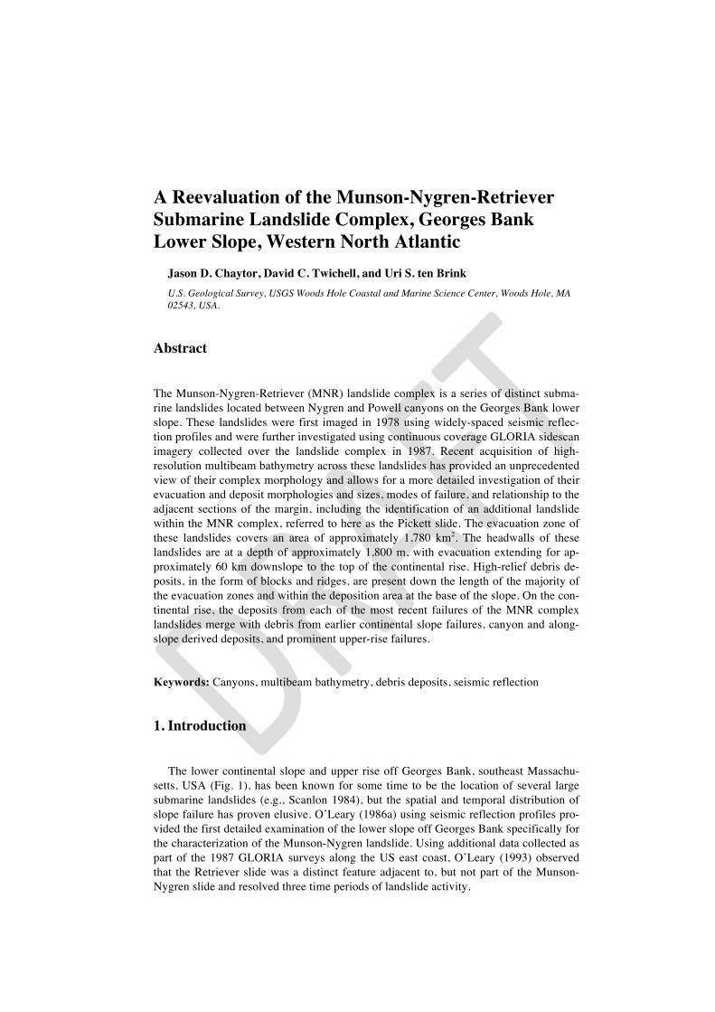
The Munson-Nygren submarine slide is the most northern and one of the largest (in terms of area and volume) surficial submarine mass failures identified along the US At-lantic continental margin. The morphology of the evacuation zone of Munson-Nygren slide bears the characteristics of a retrogressive landslide, but is complicated by its in-teraction with an unnamed canyon and a large secondary landslide on the northern flank of the main scar (flank slide; Fig. 2). Because of a lack of cores and high-resolution seismic reflection data, the mode of failure for the Munson-Nygren slide is unknown,
4
but may be similar to that of the Logan Canyon debris-flow corridor on the Scotian slope (Mosher et al., 2004).
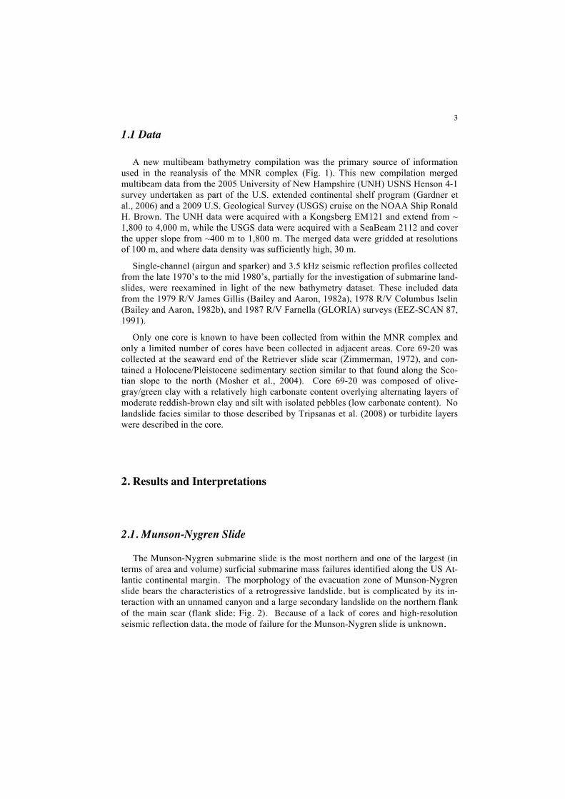
The downslope length of the main evacuation zone is approximately 60 km, with a maximum width of approximately 12 km, excluding the width of the adjacent canyon and a secondary landslide. These values are significantly different from those of O’Leary (1986a), who measured a length of at least 35 km and a width of 20 km. The headwall is characterized by a series of concave, stepped scarps that cut slope gullies, the shallowest at a depth of 1,790 m (present only along the western side of the evacua-tion), the main headwall scarp at approximately 1,880 m, and the lower scarp at approx-imately 2,230 m (Figs. 2 and 3). The main headwall scarp has a maximum height of 280 m, while the maximum heights of the lower and shallow scarps are only 100 m and 50 m, respectively. Seismic reflection profiles (e.g., Fig. 3) show the presence of chaotic reflections above the main headwall, leading O’Leary (1986a) to suggest sediment load-ing by debris from an earlier failure upslope of the Munson-Nygren slide as the trigger for failure. Sidewall heights exceed 200 m along much of the length of the main evacu-ation zone and in places are prominently stepped, revealing the architecture of the upper rise stratigraghy. The gradient of the failure surface, as measured down the main axis of
Figure 2. The Munson-Nygren slide scar (evacuation zone). Prominent headwalls and sidewalls marked by red hatched lines. The yellow dashed line marks the upslope limit of blocky debris deposits. The loca-tion of the seismic profile in Figure 3 is highlighted by the white line.
5
the evacuation zone is 1.3o. A roughly circular flank slide breaches the northeastern sidewall of the Munson-Nygren evacuation zone, which may have occurred coeval with, or subsequent to, the failure of main Munson-Nygren slide. A number of small curved scarps are observed along the margin of the channel downslope of the flank slide, likely revealing the location of incipient landslides. Using the method outlined in Chaytor et al. (2009), the area and volume of the evacuation zone of the Munson-Nygren slide, in-cluding the flank landslide were calculated to be 973 km2 and 152 km3, respectively. These and subsequent area and volume values are only estimates, given the presence of debris within the evacuations and at times, poorly defined downslope lengths.
Seismic reflection profiles show that the seafloor within the evacuation zone is cov-ered by debris deposits of varying thicknesses (Fig. 3). Blocky surficial debris deposits from the Munson-Nygren slide are present within the evacuation zone of the landslide and further downslope (Figs. 1 and 2). In the upper part of the evacuation zone, blocky debris is only present at the base of sidewall scarps, but blocky and hummocky deposits become more widespread throughout the evacuation zone beginning adjacent to the flank landslide. Debris from the flank slide forms a prominent lobe at the base of the evacuation zone, infilling and blocking the channel. Beyond this, debris deposits ex-tend at least 50 km downslope from the base of the evacuation zone, infilling slope and rise channels and partially burying the base of Picket Seamount. At present, it is not clear whether these deposits are the result of a single or multiple landslide events.
Figure 3. A portion of Iselin air-gun line 26. Note the main and lower headwall scarps and the presence of chaotic (debris?) deposits above the headwall scarps (out-lined by dashed red line) and deformed stratigraphy below the lower scarp
6
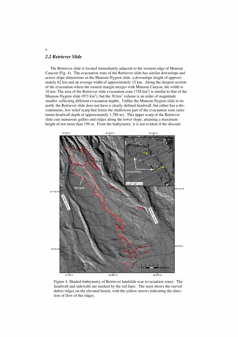
2.2 Retriever Slide
The Retriever slide is located immediately adjacent to the western edge of Munson Canyon (Fig. 4). The evacuation zone of the Retriever slide has similar downslope and across slope dimensions as the Munson-Nygren slide, a downslope length of approxi-mately 62 km and an average width of approximately 12 km. Along the deepest section of the evacuation where the eastern margin merges with Munson Canyon, the width is 16 km. The area of the Retriever slide evacuation zone (728 km2) is similar to that of the Munson-Nygren slide (973 km2), but the 30 km3 volume is an order of magnitude smaller, reflecting different evacuation depths. Unlike the Munson-Nygren slide to its north, the Retriever slide does not have a clearly defined headwall, but rather has a dis-continuous, low relief scarp that forms the shallowest part of the evacuation zone (min-imum headwall depth of approximately 1,780 m). This upper scarp of the Retriever slide cuts numerous gullies and ridges along the lower slope, attaining a maximum height of not more than 150 m. From the bathymetry, it is not evident if the disconti
Figure 4. Shaded-bathymetry of Retriever landslide scar (evacuation zone). The headwall and sidewalls are marked by the red lines. The inset shows the curved debris ridges on the elevated bench, with the yellow arrows indicating the direc-tion of flow of the ridges.

7
nuous morphology of the headwall is original or if it has undergone post failure modifi-cation (e.g., renewed canyon incision). Except for the upper 15 km of the slide, signifi-cant sidewalls are only present along the western margin of the evacuation zone, with only a low-relief lip present along its eastern side where it flanks Munson Canyon. Sidewall scarp heights exceed 100 m along most of the evacuation zone, and as with the Munson-Nygren slide, display a stepped morphology. Below 2,600 m, a number of subdued scarps are present along the eastern margin and main axis of the evacuation zone. While these scarps may be temporally related to the most recent phase of failure, it is possible that they are relict landslide or canyon features partially covered by more recent debris deposits. Seismic reflection data show that failure deposits are present down the length of the evacuation zone, but blocky surficial deposits like those associ-ated with the Munson-Nygren slide are largely absent on the bathymetry.
One of the most prominent feature of the Retriever slide is an elevated, approximate-ly 15 km-long terrace on the western flank of the evacuation zone that contains debris ridges up to 20 m high (Fig. 4), which in general conform to the shape of the adjacent sidewall scarp. Micallef et al. (2007) described a similar ridge and trough morphology within the Storegga Slide, attributing it to a spreading mechanism. The terrace on which this ridge and trough feature sits has a gradient of 2.2o, which is greater than the 1.4o gradient of the main axis of the excavation zone suggesting failure of the Retriever slide has occurred along more than one bedding plane.
2.3 Picket Slide
Between the Munson-Nygren and Retriever source scars lies the Picket slide (Fig. 5a). While this feature was initially considered to be part of the Munson-Nygren slide (O’Leary, 1986a), it has well defined head and sidewalls that are adjacent to, but sepa-rate from the Munson-Nygren and the Retriever landslides. It is the smallest of the three distinct landslides, with a source evacuation area of 76 km2 and a volume of 3 km3. The concave headwall of the Picket slide is at a depth of approximately 1880 m, and has a maximum height of 100 m. The gradient of the failure surface is approximately 1.7o. About 6 km downslope of the headwall, the bulk of the evacuation zone bends to the southwest towards Munson Canyon, while a narrow arm of the evacuation zone contin-ues downslope to the southeast (Fig. 5a) where it intersects a section of what appears to be an older landslide scar or buried canyon. Sidewalls along the western arm are dis-tinctly scalloped and stepped and their heights exceed 100 m in places. The morpholo-gy of the Picket slide suggests failure occurred as a single event, with only minor sec-ondary sidewall collapses.
Landslide deposits were funneled down both arms of the evacuation zone, but the majority of the material appears to have been focused down the southwest arm (Figs. 5a and 5b). Blocky debris deposits are present from about 2.5 km downslope of the head-wall to the top of the southeastern area of the evacuation and to the toe of the debris lobe that is located in the axis of Munson Canyon. Deposits from the Picket slide com-pletely fill the thalweg of Munson Canyon immediately below the landslide (Figure 5a). The downslope extent of landslide deposits funneled down the southeastern arm is cur-rently unknown.

8
3. Age of Slope Failure
Beyond a detailed examination of the landslide morphology, the primary interest in the reevaluation of the MNR landslide complex is the determination of the age of the failures as a means of investigating pre-conditioning factors and triggering mechanisms along the Georges Bank section of the US Atlantic margin. From the seismic reflection data, it appears that the youngest regionally correlatable units (LRU and younger) have been cut by these landslides. Because of the lack of cores collected within the evacua-tion and deposit zones, the absolute ages and sequencing of the landslides within the MNR complex are unknown and little is known about the characteristics of the sedi-
Figure 5 (a) Shad-ed-relief bathyme-try of Picket slide. The location of the seismic profile in (b) is highlighted by the white line. Note that the thal-weg of Munson Canyon (dashed yellow line) is cut and infilled by de-bris from the Pick-et slide; (b) A por-tion of Iselin air-gun line 25. Blocky debris is as much as 50 m thick. The likely failure surface is marked by the red dashed line.
9
ments involved in the failures. That said, a first approximation of the relative aging of these failures is provided by the morphology of the debris deposits and cross-cutting re-lationships of the landslide scars and canyons.
Blocky landslide debris deposits are relatively rare along the U.S. Atlantic continen-tal margin, which is likely due to a combination of landslide age (i.e., insufficient time to be buried by younger sediments) and the mechanisms of failure (i.e., disintegration of the failed mass). The presence of blocky debris associated with the Munson-Nygren, Picket, and the terrace of the Retriever slides suggests that these landslides may have occurred relatively recently, within the late Pleistocene-Holocene period. Furthermore, A recent age for the Picket slide is possible, based on the infilling of the thalweg chan-nel of Munson Canyon directly in front of the downslope end of the western arm. Simi-larly, the axis of canyon below the flank slide of the Munson-Nygren slide appears to be filled with blocky debris, indicating deposition post-dates the last canyon cutting epi-sode. Finally, debris deposits from the Munson-Nygren slide can be seen overlying and possibly cutting scars of broad continental rise landslides (Fig. 1) which have thick lay-ers of recent sediment accumulated below them. Discontinuous landslide scars are also present on the continental rise ESE of Retriever Seamount (Fig. 1), but the source of these draping sediments cannot be definitively identified. Additional high-resolution subbottom profiles and coring are needed to determine the presence and thickness of re-cent sediment drape layers overlying each of the debris deposits.
The reevaluation of the MNR complex using the new multibeam dataset reveals that the sequence of failure of the individual landslides is likely substantially more complex than previously thought (O’Leary,1986a; Twichell et al., 2009). While the reevaluation presented here supports the contention of O’Leary (1986a) that the Retriever slide (with the possible exception of the failure of the upper terrace) is the oldest of the landslides in the complex, it differs from the more detailed headwall-depth based sequencing sce-nario of Twichell et al. (2009) by the introduction of the Picket slide and a younger age for the flank slide (headwall 4A of Twichell et al.).
4. References
Bailey, N. G., and Aaron, J. M., 1982a, High-resolution seismic-reflection profiles col-lected aboard R/V JAMES M. GILLISS, Cruise GS-7903-3, over the Atlantic continental slope and rise off New England: U.S. Geological Survey Open-File Report 82-718, 2 p..
Bailey, N. G., and Aaron, J. M., 1982b, High-resolution seismic-reflection profiles from the R/V COLUMBUS ISELIN, Cruise CI 7-78-2, over the continental shelf and slope in the Georges Bank area: U.S. Geological Survey Open-File Report 82-607, 2 p..
Chaytor, J.D., ten Brink, U.S., Solow, A.R., and Andrews, B.D., 2009. Size distribution of submarine landslides along the U.S. Atlantic margin. Mar. Geo., 264, 16-27.
Danforth, W.W. and Schwab, W.C., 1990. High-resolution seismic stratigraphy of the upper continental shelf seaward of Georges Bank. U.S. Geological Survey Map, MF-2111.
EEZ-SCAN 87, 1991. Atlas of the U.S. Exclusive Economic Zone, Atlantic continental margin. U.S.G.S. Misc. Investigations Series I-2054. 174 pp.
Gardner, J.V., Mayer, L.A., Armstrong, A.A., 2006. Mapping supports potential submi-ssion to U.N. Law of the Sea. EOS Trans., Am. Geophys. Union 87, 157–159.
10
Micallef, A., Masson, D.G., Berndt, C., and Stow, D.A.V., 2007. Morphology and me-chanics of submarine spreading: A case study for the Storegga Slide. J. Geophys. Res., 112, doi:10.1029/2006JF000739.
Mosher, D.C., Piper, D.J.W., Campbell, D.C., and Jenner, K.A., 2004. Near-surface geology and sediment-failure geohazards of the central Scotian Slope. AAPG Bulletin, 88, 703-723.
O’Leary, D.W., 1986a. The Munson-Nygren slide: A major lower-slope slide off Geor-ges Bank. Mar. Geo., 72, 101-114.
O’Leary, D.W., 1986b. Seismic structure and stratigraphy of the New England Conti-nental Slope and the evidence for slope instability. U.S. Geological Survey Open-File Report, 86-118, 182pp.
O’Leary, D.W., 1988. Shallow Stratigraphy of the New England Continental Margin. U.S. Geological Survey Bulletin, 1767, 40 pp.
O’Leary, D.W., 1993. in Schwab, W.C., Lee, H.J., and Twichell, D.C., eds., Submarine landslides: selected studies in the U.S. exclusive economic zone: U.S. Geologi-cal Survey Bulletin 2002, p.
Poag, C.W., 1982. Stratigraphic reference section for Georges Bank Basin – Depositio-nal model for New England passive margin. AAPG Bulletin, 66, 1021-1041.
Scanlon, K.M., 1984. The continental slope off New England: A long-range sidescan-sonar perspective. Geo-Marine Lett., 4, 1-4.
Tripsanas, E.K., Piper, D.J.W., Jenner, K.A., and Bryant, W.R., 2008. Submarine mass-transport facies: new paerspectives on flow processes from cores on the eastern North American margin. Sedimentology, 55, 97-136.
Twichell, D.C., Chaytor, J.D., ten Brink, U.S., and Buczkowski, B., 2009. Morphology of late Quaternary landslides along the U.S. Atlantic continental margin. Mar. Geo., 264, 4-15.
Zimmerman, H.B., 1972. Sediments of the New England continental rise. Geological Society of America Bulletin, 83, 3709-3724.
Acknowledgments
We thank the U.S. Nuclear Regulatory Commission project for funding the 2009 multibeam data collection and analysis. The authors would like to express their appreciation to the officers and crew of the NOAA Ship Ronald H. Brown. David Mosher, Kathy Scanlon, and Emily Himmelstoss provided excellent reviews which improved many aspects of the manuscript. Any use of trade, product, or firm names is for descriptive purposes only and does not imply endorsement by the U.S. Government.