a report on archaeological test excavations at
TRANSCRIPT


Archaeological Report No. 10
A REPORT ON ARCHAEOLOGICAL TEST EXCAVATIONS
AT GOODE LAKE
JACKSON COUNTY, MISSISSIPPI
Richard A. Harshall
Mississippi Department of Archives and History and
Jackson County Port Authority
1982

I I
fi

i
CONTENTS
INTRODUCTION
ACKNOWLEDGEMENTS
FIELD STUDY
DESCRIPTIONS AND INTERPRETATIONS
The Setting Description of the Sites
22-Ja-543 22-Ja-544 22-Ja-545
Descriptions of Features and Comparisons
Pit Features Earth Fill (22-Ja-543) Soil Stains
Descriptions of Cultural Materials and Comparisons
Ceramics Projectile Points Flakes and Lamellar Blades Grinding and Abrading Stones Hason Wasp Nests Historic Materials
S~~Y AND INTERPRETATIONS
22-Ja-543 22-Ja-544 22-Ja-545
Interpretation
CONCLUSIONS
REFERENCES
iv
vi
3
7
7 9
9 10 11
11
11 22 27
30
30 46 49 50 51 52
53
53 56 56
57
72
75
ii
FIGURES
1. Grid Plan of Site 22-Ja-543 Excavation 4
2. Grid Plan of Site 22-Ja-544 Excavation 5
3. Grid Plan of Site 22-Ja-545 Excavation 6
4. Map of the Area Around the Goode Lake Sites 8
5. Location Plan of Pit Features at Site 22-Ja-543 13
6. Location Plan of Pit Features at Site 22-Ja-544 17
7. Location Plan of Pit Features at Site 22-Ja-545 18
8. Relative Pit Sizes, Shapes, and Depths from the Goode Lake Sites 20
9. Location Plan of Soil Stains at 22-Ja-543 26
10. Diagrammatic Representation of Soil Zones at 22-Ja-543 53
11. Location of Sites Mentioned in Comparative Discussion 58
12. A Prehistoric Culture Sequence for the Eastcentral Coast of the Gulf of Mexico 61
PLATES
1. Baytown Plain from Pit 21, 22-Ja-545 31
2. Bayou La Batre 31
3. Baytown Plain and Coles Creek Polished Plain 34
4. Larto Red Filmed, O'Neal Plain, and Mississippi Plain 34
5. Leland Incised 36
6. Marksville Incised and Marksville Stamped 36
7. Check Stamped 38
8. Mulberry Creek Cordmarked 38
9. Tchefuncte Plain and Wheeler Plain 43
10. Miscellaneous Incised, Plain, Punctated, and Red Filmed 43

iii
4711. Projectile Points from the Goode Lake Sites
12. Lamellar Flake and Abrading Grinding Stones 47
TABLES
1. Categorization and Characterization of Pit Features, Goode Lake Sites 23-25
2. Distribution of Projectile Points 49
3. Distribution of Flakes and Lamellar Blades 50
4. Distribution of Grinding and Abrading Stones 51
5. Distribution of Mason Wasp Nests at 22-Ja-543 51
6. Ceramic Series Used in Summarizing the Goode Lake Sites' Data 54

iv
INTRODUCTION
Early in 1972, the Mississippi Department of Archives and History learned of plans to construct a large sewage aeration lagoon and settlement basin at Goode Lake and on the adjacent land on the property of the International Paper Company, Moss Point Plant, Moss Point, Mississippi. This project was being sponsored by the Jackson County Port Authority. The initial plans and preparations were being carried out by the engineering firm of Michael Baker, Jr., Incorporated, of Jackson, Mississippi.
In late January, the Jackson County Port Authority contacted the Department of Archives and History regarding an archaeological survey of the proposed area in compliance with the Antiquities Law of Mississippi. The writer was contacted to conduct the survey. In mid-February the field survey was carried out with the assistance of Ray Wallace and Mark Williams, members of the Gulf Coast Chapter, Mississippi Archaeological Association.
Three small adjoining sites were located on the eastern bank of Goode Lake. Brief tests were made to check the extent of the deposits and depth of cultural materials. Though the materials were relatively sparse at two of the sites, the third site had a good deposit which was believed to represent several prehistoric occupations. In a report of the survey findings made February 22, 1972 (Marshall 1972), the following recommendations were made for possible further testing and salvage of the sites:
Site 1 (22-Ja-543): This site is potentially the most important because of the pottery and depth of the deposit. Since, however, there are two or more superimposed occupations on the site, they must be viewed as being partially mixed and thus requiring more extensive testing than the others in order to derive data which will lead to the separation of the different cultural components. It is recommended that approximately three ten-foot wide trenches be cut from the river bank for a distance of 25 to 35 feet or more to 12 inches below the base of the deposit. The purpose of this is to discover the nature of the superimposed zones, to obtain a useful collection of cultural materials for identification of the occupations, to obtain a minimum of one radiocarbon sample for dating the occupations, to locate and excavate different kinds of features related to the different components, to obtain samples of paleoflora and fauna for ecological and subsistence activity pattern reconstruction, and to evaluate the site for more extensive testing or excavation if warranted.
Site 2 (22-Ja-544): This site is potentially important because of the possibility that the two occupation zones in the highest portion are separated by a sterile zone of sand. This site could, because of the separated occupation zones, be used as a check against the excavation and interpretation of Site 1, which apparently has two zones superimposed but not separated. It is recommended that approximately three five-foot-wide trenches be cut from the river bank back for a distance of 25 feet or more to 12 inches below the base of the deepest deposit. It is also recommended that one or more test pits be dug deeper to try to determine if there are

v
deeper and older occupations. The purpose of these recommendations is the same as for Site 1, with the additional aim of obtaining information possibly leading to the clarification of the superimposed zones in Site 1.
Site 3 (22-Ja-545): This site is potentially important because of the possibility of finding a single occupation or cultural component. If so, all materials present will belong to a single cultural component and the site data can be comparatively used in the delineation of earlier or later components at other sites in the area. It is recommended that the testing on this site follow essentially the plan of the emergency effluent canal and that the test pattern consist of approximately three test squares not less than 20 feet to a side dug to a depth of approximately 12 inches below the base of the deposit. The purpose of this is the same as for Site 1.
After acceptance of the report, details were worked out regarding archaeological testing of the sites to further determine their content and extent and to evaluate their importance to Mississippi archaeology. Funds for the project, in the amount of $4,000 from the Jackson County Port Authority, were granted to the Mississippi Department of Archives and History in April, 1972.
On June 14, 1972, a field crew from Mississippi State University arrived to begin salvage test operations at the three sites. The field crew consisted of a student supervisor and seven students from the First Summer Term of the Sixth Summer Field School in Mississippi Archaeology, Mississippi State University, and this writer as director.

vi
ACKNOWLEDGEMENTS
Though many individuals were involved with this work, all of whom contributed greatly, only those who were in direct contact with the field crew are listed by name. The writer is deeply grateful for all the assistance that made this operation possible.
Numerous persons connected with the Jackson County Port Authority were involved in the initiation of preliminary contacts with the Department of Archives and History and assisted throughout the entire project. The writer wants especially to thank Charles P. Lee of the Jackson County Port Authority for his help, particularly in working out numerous small details of contact with citizens of the Moss Point-Pascagoula community which made our visit there so pleasant and enjoyable. Representatives of the Michael Baker engineering firm and the International Paper Company visited often and assisted in many ways.
Bubba Harris of the International Paper Company, Moss Point Plant, assisted in several matters directly related to the excavation. The writer is also indebted to Ray Wallace and Woody Johnson of Litton Industries for providing at no expense to the group excellent lodging at Blue Lake Manor.
This writer would also like to acknowledge with thanks and appreciation the aid of a most congenial and hardworking crew. John Glover acted as student supervisor and assisted in analysis and in the preparation of this manuscript. Students Martin Borkon, Chris Bailey, Nancy Atkins, Pam Snelson, Roger Dean, and Michael Taylor participated in the fieldwork. Donny Chandler was a paid assistant. To all of these people, whose enthusiasm and dedication made the field school and project so successful, I owe thanks. To this I must add my appreciation to my family for enduring with love and enthusiasm the difficult uprooting from a comfortable home to the "rigors" of the field.
I want to thank also Elbert R. Hilliard of the Department of Archives and History for his assistance in making and keeping contacts with the officials of the Jackson County Port Authority, Michael Baker engineering firm, and others who made the entire project possible.

A REPORT ON ARCHAEOLOGICAL TEST EXCAVATIONS
AT GOODE LAKE
JACKSON COUNTY, MISSISSIPPI


3
FIELD STUDY
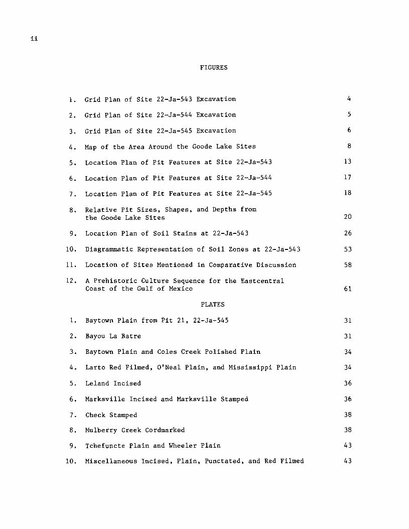
Preliminaries to test excavation of the three Goode Lake sites. which began at site 22-Ja-543 on the morning of June 15. 1972. involved clearing the test area. staking off the site. and preparing sifters. Commencement of the actual archaeological investigation was delayed because of the high wind and heavy rains of hurricane Agnes. which swept the area until June 19. Fortunately. the Pascagoula area was only on the western edge of the storm.
A grid system of five-foot squares was used for site 22-Ja-543 (Figure 1). A datum point was first placed in the southwest corner of the site at the apex of the bank overlooking Goode Lake and designated as stake E25N110 (East 25 feet. North 110 feet). With the use of a Brunton Compass and a lOa-foot steel tape. a northward line of stakes was placed at five-foot intervals from the datum point. This north-south line provided the base line for extending the grid both north and east until that portion of the site first selected for testing was covered. This grid system allowed for easy future expansion in any direction if the test area needed to be enlarged. Following placement of the grid system. the site was mapped using a one-foot contour interval.
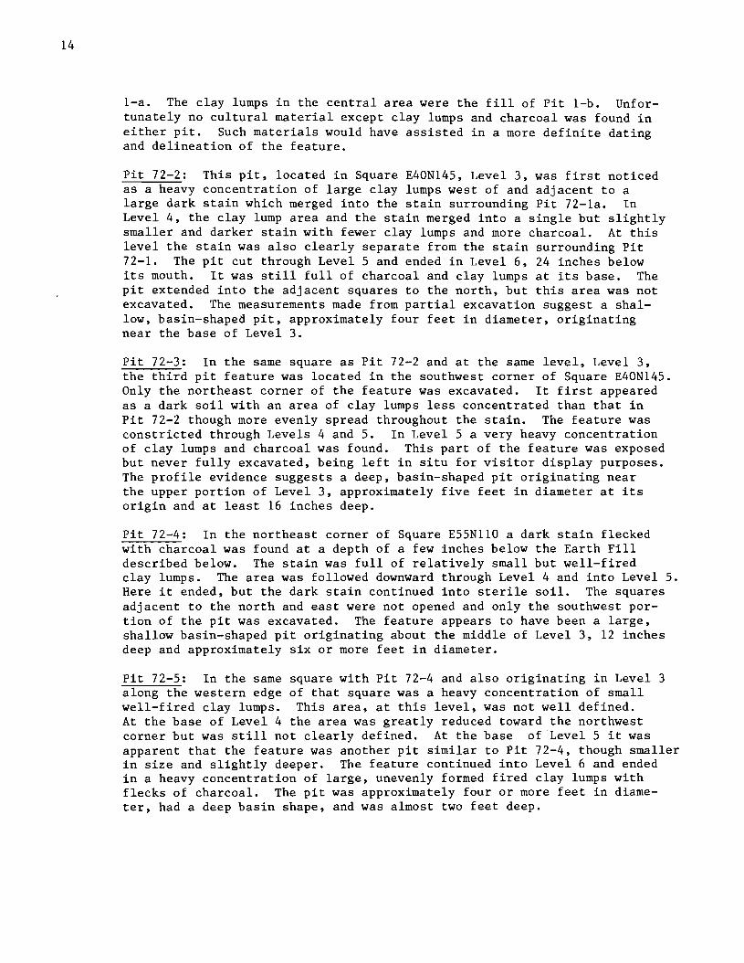
Each excavation unit (a five-foot square) was designated by the stake number in its southeast corner; this stake served as the square's reference point for all measurements. All excavation units were taken down by four-inch levels. as measured from the surface at the reference stake. Levell was surface to four inches; Level 2. four inches to eight inches; and so on. Material from each four-inch level was kept separate from that of other levels. As the excavation of each level was completed. detailed notes of artifactua1 material. photographs. and a plan of soil colors and features were made by the excavator.
A relatively flat ground surface at Site 22-Ja-543 allowed the use of line levels in recording depth measurements. A line drawn on each of the reference stakes marked the original surface level. so that the reference point remained constant in spite of possible soil erosion through rains. wind. or other possible damage. Depth readings were always taken to this line on the square's southeast stake. With the use of a string and line level. that elevation point could be duplicated anywhere over the floor of the pit for accurate measurement. Elevation at each stake was recorded on a master grid plan.
All soil from each level of each excavation unit was sifted through quarter-inch mesh hardware cloth before being discarded.
Attempts made to recover the faunal and floral remains were largely unsuccessful. Flotation recovered wood charcoal. but no charred vegetable remains were obtained even though a 1/16-inch mesh brass wire sifter was used. Only small. calcined bone fragments (from large-boned animals. probably deer) occurred. Small bone, unburned, did not exist. In an effort to explain the absence of faunal material. three soil samples from site 22-Ja-543--one each of the three obvious soil zones-- were taken. The results of the pH test, recorded below, showed all three to be slightly alkaline.

4
\
\
/ /
,/
125
115
120
-
4
3
4 3 130 \
l35
.......... N 5~150
I 5 [ 7 I6 I L!J 14~\ \
140 ' \
3 3 3 I
5 2 2 2 2
SHELL ROAD ~::;:m~
SCALE:
6 2 6 6 4 6
E 20 25 30 35 40 45 50 55 60" 0
Figure 1. Grid plan of site 22-Ja-543 excavation. Numbers in each excavation unit indicate the number of levels excavated. Contour interval, 1 foot.

5
--Margin of Site
........... -- ------ - --...... -= - @
c
0 <C
'"00 a::
~
a. ..J ..J L&J~ 0 %
~ U)-"t) ~
~ ~ NQS
@
Scale: I in. =10 ft.
Figure 2. Grid plan of site 22-Ja-544 excavation. Number in the excavation unit indicates the number of levels excavated.

6
8 B~
ION
IIJ Z
/
o o
o en-
It) .....
G~ et
0 II- C
0 0
B~ w -J
00) « rt) o ZlLl
en
Figure 3. Grid plan of site 22-Ja-545 excavation. Numbers in each excavation unit indicate the number of levels excavated.

7
Zone I (Humus and Grass Roots) No sample taken
Zone II (Ceramic occupation) 7.9
Zone III (Nonceramic occupation) 7.6
Zone IV (Sterile zone below occupation) 7.1
This would not account for the absence of animal bone. No explanation for the absence of charred vegetable remains has been proposed.
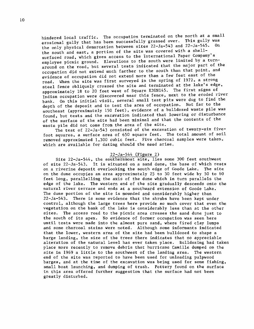
Two parallel rows of east-west test squares, separated by 30 feet, were begun across the site in an attempt to locate any features and to sample the deposit. Later, most of these test squares were joined by excavation of the intervening squares for a greater sample of materials (Figure 1). Although excavations at site 22-Ja-545 were not as extensive as those at site 22-Ja-543, they covered a much larger area (Figure 3). A grid system was used here also. The test at site 22-Ja-544 was limited to a single test pit (Figure 2).
DESCRIPTIONS AND INTERPRETATIONS
The Setting The Goode Lake sites are located on the east bank of Goode Lake, a
portion of an oxbow of the Escatawpa River. Goode Lake is situated east of Moss Point, Jackson County, Mississippi (Figure 4). The area is now greatly altered by dredging, and an accurate reconstruction of the prehistoric setting would be difficult without an interdisciplinary study. Goode Lake forms the western edge of the International Paper Company's Moss Point Plant property, which is located in the northeast portion of Moss Point and on the south bank of the Escatawpa River. The locale is typical of the tidal flat upper estuary areas of the lower Coastal Flatwoods section of the Lower Coastal Plain (Vanderford 1962). Tidal marsh and swampland make up a large part of the Coastal Flatwoods section.
In this locality, the Escatawpa River makes a series of undulating swings to the south, but with each swing there is a greater drift to the west and the eventual junction with the Pascagoula River estuary lies less than four air miles distant. All along the river are ancient oxbow lakes which have been cut off from the meandering stream. Many of these have been rejoined to the river in order to provide water access for industrial plants and private boating. In the numerous meanderings of the river, ancient terraces have been cut, and banks or "bluffs" of different elevations have been formed.
The soil of the terrace on which the Goode Lake sites are located is primarily a11uvia11y deposited sand. It is almost clean and devoid of any clay at 22-Ja-543. Site 22-Ja-545, adjacent to 22-Ja-543, south of the other sites and actually on the south bank of Goode Lake, appears to be on part of the same terrace system. The main occupation at this site, however, was found on a sand dune of considerable height next to the bank. This sand, which appears to be a windblown deposit, lies on a very sandy

oe
I'%j
t-'.
(JQ
~
t-
I ro .~ ~
'd o H'l
rt
;:T
ro Pi
t-I ro Pi
Pi
t-I o § P.
rt
;:T
ro ~
o c, ro t""
Pi
?I"
ID
Ul
t-'"
rt
ro .Ul
...-
------ I
30~
SC
AL
E:
3_~~
~_I~
~~'_
_ ~~J?~_
--
----
---
-
I I ,----
---_
.,-
119
j I • I I I 'ESC
ATA
WPA
R
I M
OS
S
PO
INT
I I I I
,---
--
I
I N

9
clay terrace deposit, probably the same system on which 22-Ja-545 is situated. The elevation of Site 22-Ja-544 is some four feet above the elevation of the other sites and perhaps as much as 11 to 13 feet above the water level of Goode Lake and the river. It is quite possible that the clean sand at site 22-Ja-543 is also largely windblown, especially on the bank, although some evidence suggests that the major portion of the sand there is part of a natural levee.
The soils in the Goode Lake area support a variety of vegetation typical of the present Gulf Coast region. The terrace on which sites 22-Ja-543 and 545 are located was planted mainly in grass and pine, although the variety of plants growing along the bank of the lake included tree oak, holly, and bay. The sand dune at site 22-Ja-544 was supporting large live oak and magnolia. This area had been greatly disturbed and deliberately planted, perhaps as was the area of the other two sites. Swamp or tidal flats adjacent to Goode Lake were covered mainly with marsh grass. Some cypress, growing at some distance from the immediate locale of the sites, was noted in the flat bottom1ands that flooded frequently as a result of tidal changes. Cypress stumps much closer to the sites suggest some recent environmental changes. Tidal fluctuations affected the elevation of the waters of the river and Goode Lake daily as much as 18 to 24 inches.
It would be difficult to reconstruct the paleoenvironment of the Goode Lake area, as it has been greatly altered by many factors. One would have to go upstream--out of the present zone of intense human activities and deve10pment--to find an area in any way comparable to the Goode Lake locale in aboriginal times. Further up the river any appreciable distance, however, one would find a lessening or a complete absence of tidal fluctuations, indicating a substantial difference from the present as well as the aboriginal environment of the Goode Lake sites.
Without discussing in detail a history of the Gulf coast, mention may be made of the identity of the aboriginal inhabitants of the area at the European contact period. Among those Indians mentioned in the early documents concerning the lower Pascagoula River basin are the Pascagoula, Biloxi, Capinan, and Moctobi (Swanton 1953). These names may refer to two or more distinct groups living adjacent to one another or to various towns of the same people. Penicaut (McWilliams 1953:5) cites Pascagoula, Capinan, Chicacha, Passaco1a (Pensacola?), and Biloxi chiefs in attendance at the first calumet ceremony at Fort Biloxi.
Description of the Sites
22-Ja-543 (Figure 1) Site 22-Ja-543 lies between the other two Goode Lake sites, situated
on what is largely a natural levee overlooking the eastern edge of Goode Lake. The site occupies an area approximately 40 feet wide and 75 to 120 feet long, para11e11ing the lake. The area of occupation was quite level over all of this distance, but there was a slight sloping of the surface from south to north toward the river. There had also been some recent filling of a low area back of the bank edge, next to the road crossing the site, apparently with the idea of eliminating an area that held water and
10
hindered local traffic. The occupation terminated on the north at a small erosional gully that has been successfully grassed over. This gully was the only physical demarcation between sites 22-Ja-543 and 22-Ja-545. On the south and east, a portion of the site was cov~red with a she11- , surfaced road, which gives access to the Internat10na1 Paper Company s employee picnic ground. Elevations to the south were limited by a turnaround on the road, but several tests indicated that the major part of the occupation did not extend much farther to the south than that point, and evidence of occupation did not extend more than a few feet east of the road. When the site was first surveyed in the spring of 1972, a strong steel fence obliquely crossed the site and terminated at the lake's edge, approximately 18 to 20 feet west of Square E30N145. The first signs of. Indian occupation were discovered near this fence, next to the eroded r1ver bank. On this initial visit, several small test pits were dug to find the depth of the deposit and to test the area of occupation. Not far to the southeast (approximately 150 feet), evidence of a bu11dozeq waste pile was found, but tests and the excavation indicated that lowering or disturbance of the surface of the site had been minimal and that the contents of the waste pile did not come from the area of the site.
The test of 22-Ja-543 consisted of the excavation of twenty-six fivefoot squares, a surface area of 650 square feet. The total amount of soil removed approximated 1,300 cubic feet. Five charcoal samples were taken, which are available for dating should the need arise.
22-Ja-544 (Figure 2) Site 22-Ja-544, the southernmost site, lies some 300 feet southwest
of site 22-Ja-543. It is situated on a sand dune, the base of which rests on a riverine deposit overlooking the south edge of Goode Lake. The site on the dune occupies an area approximately 25 to 30 feet wide by 50 to 60 feet long, para11e11ing the axis of the dune which in turn parallels the edge of the lake. The western end of the site gradually descends onto the natural river terrace and ends at a southward extension of Goode Lake. The dune portion of the site is mounded and considerably higher than 22-Ja-543. There is some evidence that the shrubs have been kept under control, although the large trees here provide so much cover that even the vegetation on the bank of the lake is considerably less than at the other sites. The access road to the picnic area crosses the sand dune just to the south of its apex. No evidence of former occupation was seen here until tests were made into the almost pure sand, where fired clay lumps and some charcoal stains were noted. Although some informants indicated that the lower, western area of the site had been bulldozed to shape a barge landing, the size of the trees there indicates that no appreciable alteration of the natural level has ever taken place. Bulldozing had taken place more recently to remove debris that hurricane Camille dumped on the site in 1969 a little to the southwest of the landing area. The western end of the site was reported to have been used for unloading pulpwood barges, and at the time of the excavation was being used for some fishing, small boat launching, and dumping of trash. Pottery found on the surface in this area offered further suggestion that the surface had not been greatly disturbed.

11
The test, a single five-foot square taken to a depth of six four-inch levels, or three feet, was excavated. One charcoal sample was taken from Pit 72-18 but has not yet been dated.
22-Ja-545 (Figure 3) This site is on a remnant riverine terrace which, because of the
meandering action of the river, extends out into the river bottom with oxbow lakes on either side, Goode Lake being the one on the west. It is a large area, flat, and covered with a good stand of pine trees approximately fifty years old. The International Paper Company employee picnic ground area is located on this site.
The soil here was rather clayey and more difficult to excavate. Several test pits dug when the site was surveyed indicated that there was some occupation, but none of any great importance. Of the three sites, this one is the largest in area, yet material was as sparse as at 22-Ja-544 or more so. Starting with the erosional gully separating this site from 22-Ja-543 on the west, the terrace extends northward for approximately 100 feet, then begins to drift eastward to turn southward. The distance across the end of the terrace is approximately 275 feet. The western half of the terrace slopes toward Goode Lake, while the northern and the eastern ends drop rather steeply, the eastern edge directly into the tidal flat marshes. The crest of the ridge is decidedly on the east side, but not more than a foot or two above the general elevation of the entire terrace. The greatest concentration of cultural material, if it could be called that, was along the northern and eastern edges of the terrace adjacent to the tidal flat and the eastern oxbow lake. The present Escatawpa River channel is situated approximately 250 to 300 feet north of the northern edge of the terrace. Goode Lake forms the western edge of the terrace.
Testing was carried out in three widely separated areas. Test Area 1 consisted of two five-foot squares separated by a distance of ten feet
\ (Squares E100N30 and El15N30). This test area was situated approximately 35 feet south of the northernmost and highest projection of the terrace system into the Escatwapa River bottom. Test Area 2, Square E200N25, was situated east of Test Area 1 and just below the terrace break toward the eastern oxbow. Here the slope was somewhat steeper than anywhere else on the terrace except one spot directly north of Test Area 1 where the land dropped almost seven feet into the tidal marsh. Test Area 3, consisting of two five-foot squares (Squares E195S35 and E200S35), was about 230 feet south of Test Area 2. Though situated on the apex of the terrace flat, it was adjacent to the break of the eastern slope. This area was a considerable distance from the eastern oxbow. Altogether, in the three test areas, 125 square feet of surface area were tested and about 190 cubic feet of soil removed. One charcoal sample, which would give a date on the pottery type Baytown Plain, var. A, for the vicinity, was taken from Pit 72-21.
Descriptions of Features and Comparisons
Pit Features (Table 1) Pit features are of interest because they often harbor debitage that
may be associated with artifacts and other cultural evidences reflecting

12
one or more specific activities on the site through a relatively short period of time. Incomplete glimpses of the past can be obtained from individual pits. These, when combined, assist in the inventory of cultural traits and patterns from the site. A number of pits were found and excavated at the Goode Lake sites.
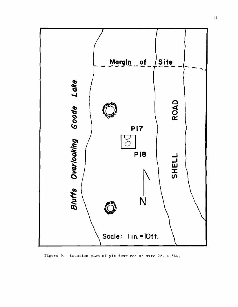
22-Ja-543 (Figure 5)
Pit 72-1: Located at the base of Levell, Square E50N145, the pit was first suggested by a dark brown soil stain with several large fired clay lumps to one side. After the stain had been followed down through Level 6 and its outline exposed in the profile, it was decided to remove the adjacent square to the west (E45N145). Here the major part of the pit was exposed to view. That portion in the adjacent squares to the south was not excavated, therefore the pit outline was not at any time clearly determined. Studies of notes, plans, and profile drawings made in the field would suggest a 4~ foot to 5~ foot diameter and a depth of approximately two feet. Some difficulty was encountered in determining just where the actual pit ended and the downward drift of soil stain from the pit into the sterile sand began. This difficulty, common to most of the pits found, will be discussed later in the description of an experiment conducted to test this condition. Clay lumps, a characteristic of the pit fill, ended at about 22 inches below the surface.
The decision to excavate Square E45N145 hinged on the fact that there was thought to be a second pit cutting into the first. According to this model, Pit i-a was seen as older and larger, while Pit 1-b was smaller, more recent, and better-defined. When the second square was excavated this interpretation was deemed incorrect by the student excavators, who perceived only one pit with a relatively dark central core containing considerable charcoal with a few lumps of clay (Pit i-b). Charcoal samples 72-1 and 72-3 were taken from this hypothesized pit. The outer portion (actually Pit i-a) was seen as the perimeter of the pit area, which had been lined with clay lumps leaving a relatively barren moderately sized clay lump central core without an admixture of charcoal from the outer area.
The writer strongly feels, along with his student assistant, that there were actually two pits making up this feature, with some time separating them in use. The evidences found at the base of Level 1 were those associated with Pit i-b. The confusion as to the pit outline is due to the mistaken identification of Pit 1-b with Pit i-a; the latter had a surface about six to eight inches lower than the former. Pit i-a is an older feature, basin-shaped, and approximately three feet in diameter. The base of the pit was undetermined. Pit 1-b, the more recent, was "U"-shaped, approximately three feet in diameter, and almost that deep. The base of Pit 1-b may actually have penetrated the base of Pit i-a. What Pit i-a appears to be is one of the larger shallow basin-shaped features, while Pit 1-b is one of the intermediate or deep "U"-shaped pits (these terms are defined in the subsequent discussion of pit features). The area where these pits were found was to the north of the major portion of the excavation tests, where the sand was finer, resembling the sand characteristic of the Third Zone. The Third Zone, however, did not clearly underlie Pit

13
NI50 E2~h1 pg: LLJ
\ ' ... '--'
PIO , ......... " - J '. -/
NIIO E20
PH Q
PI3 o
P6~ \ P7 -' . ' ...... ~
PI2
P5
C '
-..I,.,.~ ~)P4
1000----" N II0 E55
Figure 5. Location plan of pit features at site 22-Ja-543.
14
i-a. The clay lumps in the central area were the fill of Pit i-b. Unfortunately no cultural material except clay lumps and charcoal was found in either pit. Such materials would have assisted in a more definite dating and delineation of the feature.
Pit 72-2: This pit, located in Square E40N145, Level 3, was first noticed as a heavy concentration of large clay lumps west of and adjacent to a large dark stain which merged into the stain surrounding Pit 72-1a. In Level 4, the clay lump area and the stain merged into a single but slightly smaller and darker stain with fewer clay lumps and more charcoal. At this level the stain was also clearly separate from the stain surrounding Pit 72-1. The pit cut through Level 5 and ended in Level 6, 24 inches below its mouth. It was still full of charcoal and clay lumps at its base. The pit extended into the adjacent squares to the north, but this area was not excavated. The measurements made from partial excavation suggest a shallow, basin-shaped pit, approximately four feet in diameter, originating near the base of Level 3.
Pit 72-3: In the same square as Pit 72-2 and at the same level, Level 3, the third pit feature was located in the southwest corner of Square E40N145. Only the northeast corner of the feature was excavated. It first appeared as a dark soil with an area of clay lumps less concentrated than that in Pit 72-2 though more evenly spread throughout the stain. The feature was constricted through Levels 4 and 5. In Level 5 a very heavy concentration of clay lumps and charcoal was found. This part of the feature was exposed but never fully excavated, being left in situ for visitor display purposes. The profile evidence suggests a deep, basin-shaped pit originating near the upper portion of Level 3, approximately five feet in diameter at its origin and at least 16 inches deep.
Pit 72-4: In the northeast corner of Square E55Nll0 a dark stain flecked with charcoal was found at a depth of a few inches below the Earth Fill described below. The stain was full of relatively small but well-fired clay lumps. The area was followed downward through Level 4 and into Level 5. Here it ended, but the dark stain continued into sterile soil. The squares adjacent to the north and east were not opened and only the southwest portion of the pit was excavated. The feature appears to have been a large, shallow basin-shaped pit originating about the middle of Level 3, 12 inches deep and approximately six or more feet in diameter.
Pit 72-5: In the same square with Pit 72-4 and also originating in Level 3 along the western edge of that square was a heavy concentration of small well-fired clay lumps. This area, at this level, was not well defined. At the base of Level 4 the area was greatly reduced toward the northwest corner but was still not clearly defined. At the base of Level 5 it was apparent that the feature was another pit similar to Pit 72-4, though smaller in size and slightly deeper. The feature continued into Level 6 and ended in a heavy concentration of large, unevenly formed fired clay lumps with flecks of charcoal. The pit was approximately four or more feet in diameter, had a deep basin shape, and was almost two feet deep.

15
Pit 72-6: In Square E35NII0, Level 2, a very dark area was located near the northeast corner. It was not well defined even at the base of Level 3, but a heavy concentration of large, poorly-fired clay lumps mixed with a considerable amount of charcoal was exposed. At the base of Level 4 the area was well defined and found to extend into the two adjacent north squares and into the one to the east. The pit continued through LevelS but was left in place for viewing. Profiles and notes suggest a deep basinshaped or "U"-shaped pit filled with charcoal and clay lumps. The pit originated at the base of Level 2 and was at least 20 inches deep and about four feet in diameter.
Pit 72-7: Near the southwest corner of Square E45NI10, at the base of Level 3, a large dark stain was located. Instead of continuing downward to trace the stain vertically, the adjacent square to the west was opened in an attempt to follow the horizontal outline and to assist in the exposure of Pit 72-6. At the base of Level 3 in Square E40N110, Pit 72-7 continued across the south quarter and into the south profile near the southwest corner. In Level 4 of both squares this dark area appeared to be lined at its perimeter with very large, poorly fired clay lumps, and inside was an admixture of small clay lumps, sparsely scattered, large pieces of charcoal, and some mottled ash. The charcoal pieces were rather long, with the grain of the wood pointing toward the center of the feature. The large clay lumps were consistently the largest ones found in the excavations, averaging about five inches in diameter with some measuring more than eight inches in overall length. There was no evidence of shaping, but occasional impressions of sticks would suggest that large chunks from a nearby clay bank had been pried out with a digging stick and transported directly to the pit. The center of the pit was a darker color and contained considerable charcoal. In LevelS the same continued, though the perimeter of the feature was not as extensive as in Level 4 and the large clay lumps were more continuous across the feature. The pit was left open for viewing and was not further excavated. It appears that this feature was a large basin-shaped hearth-pit, approximately 6~ feet in diameter and at least 12 inches deep.
Pit 72-8: In Square E50N145, at the base of Level 2, a small dark brown soil stain occurred with what appeared to be ash near the outer edge. It was heavily charcoal-flecked throughout. This small area, approximately two feet in diameter, continued through LevelS without much change in size. Large lumps of charcoal were found and Charcoal Samples 72-2 and 72-4 were taken here. Below LevelS the area began to contract but could still be traced to a depth of 46 inches with occasional fired clay lumps found nearly all the way to the bottom. This pit was unusually deep for a narrow "U"- or "V"-shaped type and at times seemed to be a burned-out tree stump. There were, however, no evidences of lateral offshoots as there should have been with a tree stump.
Pit 72-9: At the base of Level 4, Square E30N145, a dark charcoal-flecked stain occurred in the very clean sterile sand. This area was approximately two feet in diameter and continued down through Level 8 (33 inches deep), where the stain faded out. No definite pit outline was ever obtained except

16
in Levels 7 and 8, where a concentration of clay lumps was found, helping to define the base of the pit. The feature was shallow and "U"-shaped.
Pit 72-10: In Square E25Nll0, near the base of Level 4, a dark stain appeared near the center of the northern edge. This stain was poorly defined at first, but by the base of Level 5 it was clear that it was evidence of a pit. There were a few small pieces of well-fired clay in the pit fill but not what could be called clay lumps. By the base of Level 6 the area faded out. Although little attention was paid to this stain during excavation, when the profiles for the square were recorded, a "U"-shaped outline of approximately 3-foot diameter was seen originating from near the surface of the site. Two potsherds were found in this pit, an incised rim sherd typed as Leland Incised, var. Fatherland and a plain body sherd classed as Plain Ware, var. A, both from Level 6. Numerous sherds were found throughout the loose fill of the square, particularly in the upper levels, but these two sherds are clearly associated with the feature.
Pit 72-11: At the base of Levell, in the reference corner of Square E40N125, a heavy concentration of fired clay lumps and charcoal was found in a dark gray soil stain. The clay lump concentration contained a number of large, poorly-fired lumps in a neat pile on top of a zone of well-fired small clay fragments heavily mixed with charcoal. The extent of this underlying zone was about the same size as the clay lump concentration but was situated in the midst of other concentric soil zones. The nearest one appeared to have been largely a hearth area heavily flecked with charcoal. Surrounding this was an outer area of crushed and largely pulverized clay lumps extending N-S for almost ten feet and E-W almost six feet. This appears to have been a living or activity area around the pit. The pit was followed through Level 3 and into Level 4, where it ended in a heavy concentration of clay lumps. This was a basin-shaped pit approximately 12 inches deep by about three feet in diameter.
Pit 72-12: In the square adjacent to Pit 11, Square E45N125, another area of fired clay lumps was found in a charcoal flecked darker soil at the base of Levell. In Level 2 the area was surrounded by a darker zone on the west half, but this disappeared by the base of Level 3. The area was followed down through Level 3 and into Level 4. The feature appears to have been a small hearth-pit, basin-shaped, approximately two to three feet in diameter and ten to twelve inches deep.
Pit 72-13: This pit was a small area approximately ten to twelve inches in diameter on the eastern edge of Square E35Nl15, which was distinguished near the upper "surface" of Soil Stain 8 (Level 3) and continued down into Level 5. No actual outline of the pit was recorded, but the concentration of clay lumps would suggest a deep circular "U"-shaped pit some six to eight inches or more deep.
Pit 72-14: This pit was drawn in the notes as a light tan stain in the northwest corner of Square E40N145, Levell. At the base of Level 2, the pit was somewhat better outlined and filled with clay lumps and some char
17
Cb 'b () () (,!)
Scale: lin. =10ft.
PI?
[Q] PIS
N
o <l o 0::
-' -' LLI :J: en
Figure 6. Location plan of pit features at site 22-Ja-544.

18
N 0 rr> a.[9 «
C\J w 0 a::f <{en t\Iw f- a.
~ (J) W I
-en a. - «
W L Z .,; .....0::: 0LJ « II C
D ~ .. lLJ(J) ....J <[W 0
I-(/J
Figure 7. Location plan of pit features at site 22-Ja-545.

19
coal. The pit soil was. in spite of the charcoal concentration. a light tan and very sandy. It is suggested that the pit had been left open and had filled with blowing sand. The feature appears to have been a shallow basin-shaped pit extending into Level 3. approximately ten inches deep. and possibly 4~ to 5~ feet in diameter.
Pit 72-15: See Soil Stain 5 description.
Pit 72-16: See Soil Stain 5 description.
22-Ja-544 (Figure 6)
Pit 72-17: In the northwest dark soil area with numerous
corner of the only sqbroken clay lumps and more
uare tested. than a
a large. light
occurrence of charcoal was present at the base of Levell. This area continued in the succeeding levels almost to the base of Level 4. It was 38 inches in diameter and 18 to 20 inches deep. Its profile cross-section was intermediate between the deep. basin-shaped pit category and the large diametered. shallow. basin-shaped pits at 22-Ja-543. Apparently the humus content of this pit was considerable. as the area was firmly matted with small roots from the nearby tree. A single potsherd of Tchefuncte Plain was found in the screening of the square's first level. It is not possible to be certain of this sherd's association with the pit.
A probable second pit appeared at the base of Level 2 in the center of the square. Like the other. it was full of broken clay lumps and some charcoal. Though only about six inches deep and almost 30 inches in diameter. the appearance was more like that of a hearth: a broad. shallow basin. Both pits appeared to be associated with soil stains (SS12 and SS13) that were not fully excavated due to lack of time.
22-Ja-545 (Figure 7)
Pit 72-19: In the eastern wall of Square El15N30 in Test Area 1. a cluster of clay lumps was located at the base of Level 2. This concentration. about 15 inches in diameter. continued through Level 3. where charcoal was found which extended well into Level 4. Although this feature was rather more "U"-shaped than expected for a hearth pit. this is what it may have been. It was possibly associated with an accompanying soil stain. although the darker soil appeared more likely to be a soil zone built up largely of cultivated soil and humus above the mouth of the pit. It was also in this square that an Abby Point was found at the same level as the mouth of the "pit" or cluster of clay lumps.
Pit 72-20: This was a feature located in Test Area 2. in the south profile of Square E195N55 at the base of Level 2. With the exception of a cluster of clay lumps. this feature was much like Pit 72-18. It was larger in diameter--about 30 inches--and approximately six inches deep. It was charcoal stained and had small pieces of fired clay in the fill. One piece of Baytown Plain. var. B. was found in the first level of the square but cannot be directly associated with this pit.

20
Pit 72-21: This feature, in Test Area 3, was the most significant find on the site. The pit was located in Square E200S35, approximately two inches below the base of Levell. It began with a slightly tannish-yellow charcoal flecked soil area (surrounded by the sterile, buff-colored terrace soil), about 34 inches in diameter. At the base of Level 3 there was no doubt that it was a pit feature, the soil being considerably darker and still flecked with charcoal. At a depth of 40 inches the pit was 20 inches in diameter, and its bottom rounded out at 45 inches in depth. A large and very good charcoal sample was taken about midway down in the pit. In the upper portions of the pit, several potsherds were found which fitted together to form at least one quarter of a small globular jar (Plate 1) identified as Baytown Plain, var. A. This finding indicates that the pit, probably connected with the latter ceramic levels of Site 22-Ja-543, is associated in time with the Marksville or Early Baytown Period. No soil stain was apparent for the adjacent area.
Comparative Study of Pit Features
A comparative study of the pit features from the Goode Lake sites suggests that there are three major pit types (Table 1 and Figure 8): a very broad, shallow, basin-shaped pit type; a broad, moderately deep basin or "U"-shaped pit type; and a rather narrow, deep "U"-shaped pit type. A possible fourth pit type is represented by two sma11-diametered, deep "U"-shaped pits.
LEVEL o
I
2
3
4
5
6
7
8
9
10
17 II
Figure 8. Relative pit sizes, shapes, and depths from the Goode Lake sites.

21
It appears that two of the types are more or less common to both of the major occupation zones at 22-Ja-543. There is, however, some difference in the distribution of these features, related to the depth of their occurrence. For instance, of the broad, shallow, basin-shaped pits at 22-Ja-543, only one, Pit 14, appears to be in the ceramic zone (Second Zone). At the same time, Pits 3, 4, and 7 occurred in the non-ceramic zone (Third Zone). This presents an apparent dichotomy which is further strengthened when a study of the deep basin-shaped pits is made. Of this pit type, Pits 1-b, 2, 6, 10, 11, and 12 are in the ceramic zone, while Pits I-a and 5 appear to be in the non-ceramic zone. With this data in hand from both categories of pits, it is apparent that the two types are not of the same kind and have complementary distributions. It might be pointed out here that along the northern portion of the site, the ceramic zone thinned considerably just back of the apex of the bank and that any broad, basin-shaped pit here (Pits I-a, 3, and 14) could easily begin near the surface and yet be in the non-ceramic zone. The deep, basin-shaped pits are also near the surface here, and in fact originate above the base of Level 2. On the other hand, Pit 5, at the opposite end of the excavation area, was rather deeply placed, under the historic earth fill. It is quite possible that its point of origin was not observed quite as high as it should have been. There is, then, a rather solid argument for the correlation of pit type with occupation zone.
The third major category of pit, the deep "U"-shaped pit, is exclusively a ceramic zone type at 22-Ja-543, while the fourth type, represented only by Pit 13, appears to be non-ceramic.
The data from the other two Goode Lake sites compare rather favorably with that from 22-Ja-543. At 22-Ja-544, Pits 17 and 19 are of the deep basin-shaped type. One of them, Pit 17, originated from near the surface and would probably be comparable to the same type from the Second Zone of 22-Ja-543. Pit 18, a somewhat shallow basin-shaped pit, may have in fact originated from the level above where it was first noticed and would therefore probably belong to the same zone as Pit 17. At 22-Ja-545 the three pits were each from a different test area. Pit 19 is much like Pit 13 of 22-Ja-543, being rather small in diameter but rather deep. Both pits are of a basin-shaped type although rather small and might logically be classified as of the deep, basin-shaped type because of the overall diameter-to-depth proportions. Their size and shape, however, and the uniqueness of the contents, appear to denote a different kind of use. Pit 21 clearly is of the deep "U"-shaped type, and because of the ceramics found within is comparable to those of the same type found at 22-Ja-543.
Clay lumps were a common feature of many of the pits, but the manner of occurrence of the clay lumps was not so clear. The small, deep basinshaped pits, Pits 13 and 19, were entirely filled with fired clay lumps and had almost no charcoal. Neither pit appeared to have had the clay lumps fired in place because of a lack both of charcoal and of discoloration of the soil into which the pit was cut. It is almost certain that the clay was fired elsewhere and then put into the pits. These two pits may be some kind of baking oven or may possibly be associated with a sweat bath.
The deep "U"-shaped pits had rare, and then only small, clay lumps in their fills. They had, however, large samples of charcoal, with the

22
exception of Pit 9, where only a few charcoal flecks were noted. It appears certain that the clay lumps were fired in place in these pits. This is particularly convincing after the experiment which was conducted at the site and which is described later. Pit 8 had a few charred hickory nut shells in it and this constituted the total floral sample from the site. The possible purpose of such deep pits is unclear.
It is interesting to note that the pits in which large and heavy concentrations or clusters of clay lumps were found were mostly the deep, basin-shaped pits. But of these, Pit 10 had no clay lumps in it at all. That pit did, however, have some pottery in it, sharing this feature with Pit 21 at 22-Ja-S4S, a deep "U"-shaped pit type on the basis of its proportions and the presence of ceramics. Pits of this category also appear to have had fires in them and are often, in their individual descriptions, referred to as hearth-pits. Here again, it is hard to account for the presence of fires in such large deep pits. Although cooking might have been part of the activity associated with the feature, the lack of ceramics and bone debris in the fills might suggest sweat bath activities rather than food preparation.
The broad, shallow basin-shaped pits also had clay lumps in their fills. The clay lumps were, on the average, much larger than those found in the deep, basin-shaped pits. Also, because of the great diameter of this type of pit, a common feature was a variable distribution of clay lump sizes within. The very large-sized clay lumps were usually around the perimeter of the pit, often intermixed with large lumps of charcoal, remains of logs burned in place. Toward the center of the feature the clay lump sizes diminished and the incidence of small pieces and flecks of charcoal and what was probably ash increased. There was also greater evidence for disturbance in the centers of pits of this type. With these characteristics, it appears that the shallow, basin-shaped pits were used largely as hearths, but the diameters are far too great for only this use. It is probable that these large shallow basin-shaped features were at least partially food preparation features where large pieces of wood, burning slowly, even smoldering, with clay lumps as radiators, were used in driving off moisture from foodstuffs being prepared for storage. Further discussion of this topic will be presented later.
Earth Fill (22-Ja-S43)
In the southeast corner of the excavation area of site 22-Ja-S43, particularly in Squares ESSNIIO, ESONllS, and ESSNllS and extending partially into the adjacent squares, a zone of compact, relatively sterile, gray ashy-like soil was located immediately below the grass root zone and loose surface soil. At the outset it was apparent that a different situation prevailed than at other excavation units at the site. This area was the lowest portion of the site back of the descending bank of Goode Lake. Imbedded in the soil were occasional clam shells, iron nails, and fragments of bottle glass. The presence of clam shells, which were used to surface adjacent access roads, along with the other historic materials indicated that this zone was recent. It was later determined that the fill had been put in to elevate the surface and prevent the collection of water in a depression. That part of the site next to the road had been used for

TABL
E 1:
C
ATE
GO
RIZ
ATI
ON
AND
C
HA
RA
CTE
RIZ
ATI
ON
OF
PI
T
FEA
TUR
ES,
GOOD
E LA
KE
SIT
ES
A.
Bro
ad,
Sh
allo
w,
Bas
in-S
hap
ed P
its
22
-Ja-
54
3
Pit
3:
Mo
der
ate
sized
cla
y
lum
ps
co
ncen
trate
d
in d
ark
so
il w
ith
co
nsi
dera
ble
ch
arc
oal
Pit
4:
Mo
stly
sm
all
cla
y
lum
ps m
ixed
th
rou
gh
o
ut
dar
k so
il w
ith
fl
eck
s o
f ch
arc
oal
Pit
7
:
Lar
ge
cla
y
lum
ps
aro
un
d
the p
eri
mete
r w
ith
sm
all
er
cla
y
lum
ps
co
ncen
trate
d
in cen
ter
Pit
14
:
Mo
der
ate
sized
cla
y
lum
ps m
ixed
th
rou
gh
o
ut
sli
gh
t st
ain
wit
h
fleck
s o
f ch
arc
oal
Pit
15
: S
par
se m
od
erat
e si
zed
cla
y
lum
ps m
ixed
w
ith
so
me
ch
arc
oal
fleck
s
Pit
16
: M
od
erat
e si
zed
cla
y
lum
ps m
ixed
th
rou
gh
o
ut
sli
gh
t sta
in w
ith
fl
eck
s o
f ch
arc
oal
22
-Ja-
54
5
Pit
20
: M
od
erat
e si
zed
cla
y
lum
p clu
ster
near
cen
ter
wit
h
fleck
s o
f ch
arc
oal
B.
Dee
p B
asin
-Sh
aped
Pit
s
22
-Ja-
54
3
Pit
I-
a:
Lar
ge
cla
y
lum
ps
to
one
sid
e a
nd
aro
un
d
peri
mete
r w
ith
ou
t ch
arc
oal
Pit
1
-b:
Mo
der
ate
sized
cla
y
lum
ps cen
trall
y
locate
d
and
co
ncen
trate
d in
dar
k so
il
mix
ed w
ith
ch
arc
oal
Dia
met
er
5'
6+'
6~'
5+'
4~+'
6'
3'
5~'
3'
Dep
th
16"
12"
12"
10"
10" 8"
6"
?24+
"
36
"
Rem
arks
Sid
es sli
gh
tly
co
nst
ricte
d.
Pit
m
ay b
e in
term
ed
iate
wit
h d
eep
basi
n
shap
ed
typ
e.
Bro
ad fl
at
bo
tto
m.
Bro
ad fl
at
bo
tto
m.
Bro
ad fl
at
bo
tto
m.
See
S
oil
S
tain
1
0.
Bro
ad fl
at
bo
tto
m.
See
S
oil
Sta
in
5.
Su
per
imp
ose
d in
Pit
1
6.
Deta
ils
no
t cle
ar
bec
ause
o
f P
it
15.
See
S
oil
S
tain
5
.
Bro
ad fl
at
bo
tto
m.
Bas
e u
nd
eter
min
ed.
C-1
4 S
ampl
es
1 an
d
3 co
llecte
d.
N
W

N
+:
TABL
E 1
(Co
nti
nu
ed):
22
-Ja-
54
3
Pit
2:
M
od
erat
e si
zed
cla
y
lum
ps
thro
ug
ho
ut
dar
k s
oil
wit
h c
harc
oal
Dia
met
er
4'
Dep
th
24"
Rem
arks
See
So
il S
tain
11
.
Pit
5
: S
mal
l cla
y
lum
ps
co
ncen
trate
d w
ith
fl
eck
s o
f ch
arc
oal
4'
23"
See
So
il S
tain
2.
Pit
6:
L
arg
e cla
y
lum
ps
co
ncen
trate
d i
n a
st
ain
wit
h c
on
sid
era
ble
ch
arc
oal
dar
k
4'
24"
Bel
on
gs
to S
oil
S
tain
1.
Pit
10
: N
o cla
y
lum
ps
so
il st
ain
o
r ch
arc
oal
bu
t so
me
dar
k
3'
36"
Po
ttery
ass
ocia
ted
. T
his
fe
atu
re
cou
ld b
e a
dee
p
"U"-
shap
ed p
it a
s w
ell
.
22
-Ja-
54
5
Pit
11
: M
od
erat
e si
zed
cla
y
lum
ps
co
ncen
trate
d
in d
ark
st
ain
wit
h co
nsi
dera
ble
ch
arc
oal
3'
12+
" A
sso
ciat
ed w
ith
a
larg
e so
il a
rea
char
ged
wit
h c
lay
lu
mp
frag
men
ts.
See
So
il S
tain
5.
Pit
12
: M
od
erat
e si
zed
cla
y
lum
ps
scatt
ere
d
thro
ug
h d
ark
so
il sta
in w
ith
ch
arc
oal
fleck
s
2+
' 12
"
22
-Ja-
54
4
Pit
17
: M
od
erat
e si
zed
cla
y
lum
ps
thro
ug
ho
ut
dar
k st
ain
wit
h ch
arc
oal
fleck
s 3+
' 20
" Se
e S
oil
Sta
in
12.
Pit
18
: M
oder
ate
sized
cla
y
lum
ps
thro
ug
ho
ut
dar
k s
tain
wit
h ch
arc
oal
fleck
s 2~'
12
+"
See
S
oil
Sta
in
13.
C.
Sm
all.
B
asin
-Sh
aped
Pit
s 2
2-J
a-5
43
P
it
13:
Mo
der
ate
sized
cla
y
lum
ps
co
ncen
trate
d
and
fill
ing
th
e
featu
re w
ith
no
ch
arc
oal
1'
8"
See
S
oil
Sta
in 8
.

TABL
E 1
(C
on
tin
ued
):
22
-Ja-
54
5
Pit
19
: M
od
erat
e si
zed
cla
y
lum
ps
co
ncen
trate
d
and
fi
llin
g
the fe
atu
re w
ith
d
ark
sta
ined
so
il
flec
ked
wit
h c
harc
oal
D.
Dee
p,
"V"-
Sh
aped
Pit
s
22
-Ja-
54
3
Pit
8:
Sm
all
cla
y
lum
ps li
gh
tly
sc
att
ere
d
thro
ug
ho
ut
sli
gh
t so
il st
ain
wit
h
co
nsi
dera
ble
ch
arc
oal
Pit
9:
Sm
all
cla
y
lum
ps co
ncen
trate
d in
th
e
bas
e o
f th
e fe
atu
re.
So
il d
ark
and
fl
eck
ed
wit
h c
harc
oal
22
-Ja-
54
5
Pit
21
: N
o cla
y
lum
ps
exce
pt
for
a sm
all
clu
ster
near
cen
ter
of
pit
. S
oil
fl
eck
ed
wit
h
ch
arc
oal
exce
pt
for
sin
gle
co
ncen
trati
on
n
ear
cen
ter
Dia
met
er
Dep
th
Rem
arks
1+
' 12
"
2'
46"
Hea
vy
co
ncen
trati
on
of
ch
arc
oal
gav
e C
-14
Sam
ples
2
and
4.
2'
33"
2~'
46
" C
14 S
ampl
e 5
and
po
ttery
fo
und
(Pla
te
1).
N
VI

26
,." ~
., _ , "" ""' ... '"E25
- .. ESO
NI50 D N'50 :'1 ~!~.5!~'D ~ ,""- .... --_ .... - .
::-....", ... " \I
' \59:
I
,
J \ I , \
\
J \
/S3
\ I
54 ;
52
N II 0EL...-2-0--------IE2~IO
Figure 9. Location plan of soil stains at site 22-Ja-543.

27
picnic parking. International Paper Company employees, who often visited the site, later concurred with this interpretation.
Soil Stains
22-Ja-543 (Figure 9)
While describing the various pits from 22-Ja-543 it was mentioned that at the level where they first appeared soil stains accompanied some of them. These stains have been plotted for the different excavation levels of the site. They are true features though some are more or less interpolated from the records and drawings of the soil color changes made by the different excavators when the level records were made. They are significant in that they represent occupation activity areas. It was assumed early that the artifacts found on or within the stains were likely to be associated in some way with those activities. It was also thought that a careful study of the stains and the artifacts would help delineate individual occupations and assist in identification and interpretation of the activities. Though the assumption may have been sound, the data did not bear it out.
Soil Stain 1: This zone appeared at the base of Levell in the area of reference stake E35Nl15. It was marked by a concentration of fired clay fragments and a dark brown soil at the base of Level 2. The surrounding soil color was a beige tan while the stain was dark gray-brown heavily mottled with fired clay fragments. By the time the base of Level 3 was recorded the stain had been completely removed. On the south edge of that area in Square E35Nl15 the outline of Pit 72-6 was recorded. Aside from the clay lumps, two small triangular arrow points (Fresno and Madison Points) and a large number of late period potsherds were found. The types represented for this square were Leland Incised, var. Fatherland, confined to the southwestern edge of the site, and Leland Incised, var. Natchez, confined strictly to the area of Soil Stain 1. It is assumed that this stain and Pit 72-6 belong to the very late protohistoric Mississippian and/or to the Early Historic Period.
Soil Stain 2: Directly below the Earth Fill in the southeast area of Square E45N110, a second soil stain was found. The stain in Level 2 extended from that square well into Squares E55N110 and E55Nl15. This was a thin elliptical area and by the base of Level 3 had been completely removed. It is interesting that no artifacts were recorded for this stain, though in the area adjacent in Square E45Nl15 some, of the oldest pottery collected was found. Below this area, in Square E55N110, Pit 72-5 was located, but there did not seem to be direct association between Soil Stain 3 and Pit 72-5. It is quite possible that this stain, because of the absence of artifacts, is a product of the low physiography and contour of the area in which the square was located. Stain 2 may have been formed when soil was washed from higher portions of the site and may not be directly associated with any Indian occupation, although the natural deposition of erosional soils was not sufficient to prevent impoundment of water by historic times.

28
Soil Stain 3: At the base of Levell, centering more in unexcavated Square E50N125 but visible in the adjacent excavated squares, was a lighter than usual soil zone. This area was flecked with some charcoal. Covering the south edge of the area was the historic Earth Fill described earlier. The zone contained a number of potsherds but no lithics. It was lightly mottled with fired clay fragments and a possible hearth was found on the southeast edge of the area. At the base of Level 2 the area darkened somewhat and the fired clay fragments and charcoal flecks increased in number. This is probably the base of the stain, since in Level 3 the area of fired clay fragments expanded greatly to the north and dropped off considerably to the south, suggesting still another and earlier activity area.
Soil Stain 4: This area was located at the base of Level 2, Squares E55N110 and E55Nl15. Only the western portion of the stain was found, while the rest lay under the unexcavated squares to the east. It was a somewhat darker area than the surrounding soil and lay directly below the even darker Earth Fill described earlier. This, like the Earth Fill, was an historic deposit and contained clam shells, nails, and glass, though somewhat older than that in the Earth Fill.
Soil Stain 5: Several rings of soil color change have already been mentioned for Pit 72-11, Levell, Square E40N125. These will be referred to collectively as Soil Stain 5 rather than separated as poorly defined color changes. We must mention that although the mouth of Pit 72-11 was apparent at the base of Levell, Soil Stain 5 did not appear until the base of Level 2 was reached. The soil stain was made up of more or less concentric rings. Ring 1 next to the pit was of a dark brown soil, heavily flecked with charcoal and containing some clay lump fragments. The other ring, Ring 2, was heavily charged with clay lump fragments and did not completely encircle Ring 1 and Pit 72-11. A portion of what appeared to be Ring 1 persisted to the base of Level 3. In studying the records, profiles, and plan drawings of the excavation, it now seems to this writer that another case of superposition has been recorded. Pit 72-11 was cut into a pit (Pit 72-15) incorrectly identified as a soil stain. Pit 72-15 was a shallow basin-shaped pit of approximately four to five feet in diameter and six to ten inches deep. That pit, in turn, had been cut into an even earlier, broad pit (Pit 72-16), possibly basin-shaped or more likely a hearth-activity zone, approximately six feet in diameter and about six to eight inches deep.
Soil Stain 6: Primarily in Square E45N130, Level 3, but also extending into the two squares opened to the west and south, there was a dark brown soil stain which contained a greater than usual number of small clay lump fragments. The clay lumps were better fired than usual for the site. This area faded out to the west in Square E40N130, but remained rather well defined to the south, where it ran under Soil Stain 3 and the outer limits of Soil Stain 5. The area was apparently devoid of artifacts other than fired clay lumps.

29
Soil Stain 7: An irregularly outlined area of dark tan soil was recorded for Level 3, Square E35Nl15. The stain extended southeast into the adjacent three squares at this same level. Pit 72-6 was found on the southern edge of this area. The stain's major characteristic was a high clay lump and charcoal content, while the areas outside it were much less densely mingled with clay and charcoal and were generally lighter in color. The area immediately to the north was an exception, being darker (Soil Stain 8). Soil Stain 7 was probably a hearth area as it did not extend through the following level. A few artifacts were found but cannot be directly associated with the feature.
Soil Stain 8: Also in Level 3, Square E35Nl15, and extending into the two adjacent squares to the east and north, was another area of dark brown soil. This area was mottled with fired clay lump fragments and charcoal. Near the center of the area was a concentration of large clay lumps in a !lU"-shaped pit (Pit 72-13), which extended down through Level 4. This area was probably a hearth-activity zone not quite so old as Soil Stain 7, since it extended over the latter to some degree. There was no evidence of the stain in Level 4. Because of the continuation of Pit 72-13 below Soil Stain 8, it is highly possible that the area was a hearth-activity zone.
Soil Stain 9: At the base of Level 4, Square E40N130, a lighter tan soil zone was recorded. This area covered approximately two-fifths of the level and extended into the adjacent squares to the south and west. The corresponding level of the southern squares was not excavated, so the soil zone could not be followed out. A group of clay lumps were found in the southeastern portion of this stain adjacent to the historic fencepost mold.
Soil Stain 10: In Square E40N145, at the base of Levell, there was a dark brown soil stain, the outline of which was most irregular. Much of this irregularity was due to the disturbance of what, in Level 2, had been identified as Pit 72-14, though the stain was not clear even there. The area was flecked with small fired clay lump fragments and a few potsherds. One small area of clay lumps was found near the center of the southeast quadrant of the square. No outline of any feature was recorded for these clay lumps, but it was an area much like Pit 72-13 though not as deep.
Soil Stain 11: In Square E40N145, northeast quadrant, another soil stain began to show up at the base of Level 2 as Soil Stain 10 began to fade. The area was heavily charged with large pieces of charcoal and numerous fist-sized clay lumps. The soil was dark brown to almost black. It was also a little more compacted than the surrounding soil. By the base of Level 3, this area was still the same approximate size as in Level 2. This may have been a pit rather than a soil stain, since Pit 72-2 was found at the base of Level 3. The entire area might be considered as Pit 72-2, but the profiles and plan drawings suggest that this may be another series of superpositioned pits, Pit 72-2 as described being cut into Soil Stain 5, which may be interpreted as a large activity area or a large shallow basin-shaped pit approximately five feet in diameter.

30
22-Ja-544
Soil Stain 12: The profiles of the excavation suggest that associated with Pit 72-7 there was a dark stain below the humus line and at the same level as the mouth of the pit. No evidence as to the area covered by this feature was recorded. The single sherd of Tchefuncte Plain from this square probably came from this zone, placing Soil Stain 12 in the Tchula Period.
Soil Stain 13: Seemingly associated with Pit 72-1 at the initial level of its occurrence was a dark soil horizon recorded throughout the profiles for the test square.
22-Ja-545
No soil stains were observed or recorded for this site. The darker soil zone in which Pit 72-19 was found has previously been mentioned as a possible zone disturbed by cultivation. There are, however, several sherds of Bayou La Batre Plain, and possibly one sherd of Bayou La Batre Cord Wrapped Dowel Impressed from Levell of the adjacent square of Test 1. In view of this occurrence, it might be assumed that any soil stain found superimposed over the mouth of Pit 19, believed to be associated with the Archaic occupation, is not associated with the pit. There is no assurance that the level at which the Bayou La Batre pottery occurred is connected either with the assumed soil stains above Pit 19 or with Pit 19.
Though there were zones in which rare sherds of pottery occurred in the other test areas at 22-Ja-545, there was no evidence of features of the kind described here as soil stains. The occurrence of pottery within a shallow and delimited zone does not imply the existence of soil stains.
Descriptions of Cultural Materials and Comparisons
There was not a great variety in the kinds of cultural materials recovered from the three Goode Lake sites. The most frequently found artifact type was fired clay lumps, few examples of which bore any particular sign of having been shaped. Those that bore some evidence of shaping presumably resulted from an effort to compact the crumbly riverine terrace clay. The most striking, variable, and useful artifacts found were the potsherds. Numerous sherds were found at 22-Ja-543, very few at 22-Ja-544 and 22-Ja-545. Description and comparison of the pottery forms the basis of the chronological and sequential interpretations made in this report. Next in importance to the ceramics are the lithic materials, of which only a few really diagnostic examples were found. It is unfortunate that all evidence of food bone and shell seems to have disappeared. Also, no heavy concentration of charred vegetal remains other than wood charcoal was found. Such evidence could have formed the basis for a study of subsistence activities at the sites and in the area. Without it, interpretation must be limited to chronological and functional studies.
Ceramics (Plates 1-10)
The pottery from the excavations is described here, either as examples

31
Plate 2. Bayou La Batre Pottery. Top row: A, B, a n d C, Bayou La Batre Plain; center row: D, Bayou La Batre Stamped , and E, Ba you La Batre Cord Wrapped Dowel Impressed; bo t t om r ow: F, G, a n d H, Mi s c e l laneous Ba you La Ba t r e paste sherds.
Plate 1. Baytown Plain sherds from Pit 21, site 2 2-Ja-545. The sherds form approximately one quarter of a beakershaped jar.

32
of known and already described types and varieties of pottery or as sorted categories of similar potsherds. The latter appear to represent a "type" of pottery which could have cultural and chronological significance and for which no comparable known type could be found. Some of the miscellaneous categories were so small that it was too difficult and perhaps would be misleading to try to find comparative material in the literature. Twenty types or varieties of known prehistoric or early historic pottery and 10 miscellaneous categories are described.
Bayou La Batre Pottery
Bayou La Batre Plain (Wimberly 1960:71-4) This is a sample of 27 sherds, all except two from 22-Ja-543. The
pottery has the diagnostic features characteristic of Bayou La Batre Plain (Plate 2: A, B, and C). The pottery in this category is mainly sand-tempered, with very few inclusive pieces of large grit (1 rom). The sand is, however, much larger-grained than the sand-tempering in the Alexander ware type O'Neal Plain (Haag 1939). This is the basis for separating the Bayou La Batre ware from Alexander ware.
Chronological Position: Possibly Poverty Point to Early Tchula.
Bayou La Batre Stamped (Wimberly 1960:64-8) There is one sherd of pottery which can be identified as Bayou La
Batre Stamped from 22-Ja-543 (see Plate 2: D). This one sherd is quite different in paste from the Bayou La Batre Plain ware. The sherd has very little of the sand-tempering so characteristic of the plain. In place of the sand there is a moderate amount of large sand grains (3 rom to 6 rom in diameter) with some presumed clay, giving the paste a very contorted, Tchefuncte-like look (Ford and Quimby 1945).
Chronological Position: Possibly Poverty Point to Early Tchula Period.
Bayou La Batre Cord Wrapped Dowel Impressed (Wimberly 1960:68-70) There is one sherd identified as this type. The cord impressions are
rather widely spaced over a very carefully smoothed surface. The impressions are clear and deep (see Plate 2: E).
Chronological Position: Possibly Poverty Point to Early Tchula Period.
Miscellaneous Bayou La Batre Paste Sherds There are three sherds here classed as Bayou La Batre ware. One of
the sherds is stamped with a fine linear check (Plate 2: F). This technique and mode cannot be confused with Bayou La Batre Stamped (Wimberly 1960:64-8), as the stamping under discussion is quite different and much more regular than scallop shell drag-and-jab stamping. The paste of the sherd is rather smooth with a moderate amount of sand used in addition to the usual quartz grit, and is not greatly contorted. A second sherd has a characteristic Bayou La Batre paste. It is a very carefully smoothed sherd and has rather small hollow reed stamping (4.5 mm diameter) across the surface forming a curvilinear line (Plate 2: G). Parallels for this decorative mode are undetermined. The third Bayou La Batre sherd has very fine parallel incised lines on it (Plate 2: H). This sherd could very easily be classified as Alexander Incised (Phillips 1970:37 and Haag

33
1942:514-15) if not for the abundant large sand used as tempering (identical with the Bayou La Batre paste described above).
The latter sherd raises a question. How sandy does a paste have to be before it can be classified as Alexander ware, and how large must the aplastic sand and grit be before it can be classified as Bayou La Batre ware? There is a strong feeling that both Alexander and Bayou La Batre wares are closely related and that this is certainly one subject that requires further study before a careful, technical, and successful separation between the two wares can be made. Some researchers would have Alexander ware developing out of Bayou La Batre ware. In this regard, it might be pointed out that there is a similarity between Bayou La Batre ware and the Black Sands ware (Cole and Deuel 1937) found in Illinois, though there are certainly some differences in the decorative techniques and modes. Temporal problems may exist, but they may not be so serious as to rule out the possibility of relationship.
The problem of Bayou La Batre ware and Alexander ware is certainly very confused, and more confusion results when Tchefuncte sherds are brought into the discussion. People who regularly handle Tchefuncte sherds often assign the sandier sherds to Alexander paste ware, but no satisfactory separation can be found between Tchefuncte and Alexander paste sherds on some sites. Sometimes the Tchefuncte sherds are quite sandy, making them Alexander if the basic type description is adhered to, even when some sand is presumably in Tchefuncte paste. The problem is further complicated by the presence of Bayou La Batre paste sherds in the same or similar samples. This writer has, on several occasions, examined large samples of sandy paste sherds, some of which would be sorted as Bayou La Batre Plain (Wimberly 1960). At the same site, however, Alexander Incised, which was described as having a finer paste, might be found. And sometimes the same kind of paste that would be sorted as Bayou La Batre is incised with the Characteristic Alexander Incised designs, as is the case here. What then is the separating characteristic between Bayou La Batre Plain and O'Neal Plain (Haag 1939:6) versus Tchefuncte Plain? Is it sandy paste? Or is it the amount and size of the sand? One other sherd of what could be called an Alexander paste ware, a sherd of O'Neal Plain not discussed above, was found in the series of excavations reported on here. The sherd described above is identified as an Alexander Incised motif on a Bayou La Batre paste sherd.
Chronological Position: Late Tchula.
Baytown Plain Pottery
Baytown Plain (Phillips 1970:147-57; Ford, Phillips, and Haag 1955:76-80), var. A
The sample consists of 196 sherds from 22-Ja-543, of which 11 are rims and the remainder are body sherds (Plate 1 and Plate 3: A), and 7 sherds (including one rim) from 22-Ja-545 (Pit 72-21). The pottery was fired consistently to a buff or tan color. There are, however, occasional sherds shading into the darker shades of red-gray and brown-gray. A few sherds are fired a very bright, light tan. This pottery is relatively well finished and smoothed. The paste is clay tempered ware, but the tempering particles are quite small and very evenly mixed through the

34
Plate 3. Baytown Plain varieties and Coles Creek Polished Plain. Top row: A, Baytown Plain, var. A, B, Baytown Plain, var. B, and C, Baytown Plain, var. C; bottom row: D. E. and F, Coles Creek Polished Plain.
Plate 4. Larto Red Filmed, O'Neal Plain, and Mississippi Plain. Top row: A, Larto Red Filmed, B, O'Neal Plain; bottom row: C, Mississippi Plain, var. A, D, Mississippi Plain, var. B.

35
paste. It does not have the contorted appearance of Tchefuncte Plain (Phillips 1970:162-64), but is evenly mixed and compacted, and apparently small particles have been floated to the surface. This ware is comparable to the Baytown Plain, var. Marksville (Phillips 1970:50). The rims all appear to be from vessels that are of the beaker shape with slightly constricted mouths or straight rims. There is no evidence of rim folding on any of the vessels, the rims being very carefully smoothed and rounded at the lip. The entire sample from 22-Ja-543 ranges through the top five levels of the excavation; however, by far the greatest portion occurred in the first two levels, with a very small percentage occurring in Levels 3, 4, and 5.
Chronological Position: Marksville and/or Early Baytown Periods.
Baytown Plain (Phillips 1970:47-57; Ford, Phillips, and Haag 1955:76-80), var. B
This sample consists of 196 sherds of which 19 are rims, the remainder body sherds, all from site 22-Ja-543 (Plate 3: B). The sample as a whole consists of rather carelessly smoothed sherds, mostly fired to a light gray but ranging from a very dark gray on toward a buff color. The rims all appear to be from beaker-shaped or straight-sided vessels with slightly constricted to straight rims. There are no basal sherds in this sample. Several of the sherds have been rather severely gnawed by rodents. The sample was found in the first four levels of the site, with only a few sherds found in Levels 3 and 4. It appears to resemble the variety of Baytown Plain more commonly associated with the Baytown or Coles Creek Complexes.
Chronological Position: Baytown and/or Coles Creek Period.
Baytown Plain (Phillips 1970:47-57; Ford, Phillips, and Haag 1955:76-80), var. C
This sample consists of 11 sherds, all of which are very finely tempered with crushed clay and what appears to be a little bit of sand or mica grit (Plate 3: C). The sand particles in the tempering show through the surface, but cannot be felt. The sherds are all very carefully smoothed. They range in color from a dark red-gray to a buff-tan. The sample is possibly a coastal variety of some of the Coles Creek Period pottery and resembles Coles Creek Plain. The entire sample was confined to the first two levels of site 22-Ja-543.
Chronological Position: Late Baytown and Coles Creek Periods or later.
Coles Creek Polished Plain (Ford 1951:68-70; Ford, Phillips, and Haag 1955:94-5)
This is a sample of pottery consisting of 30 sherds, four of which are rims, all from site 22-Ja-543 (Plate 3: D, E, and F). The sample has a rather wide distribution through the four ceramic levels of the site; very little of it occurred in Level 3. A large portion of the sample, however, occurred in Level 4. The pottery is inordinately thin, characteristically Coles Creek Polished Plain.
Chronological Position: Coles Creek Period.

36
Plate 5. Leland Incised. Top row: A, B, and C, Leland Incised, var. Fatherland; bottom row: D, E, and F, Leland Incised, var. Natchez.
Plate 6. Marksville Incised and Marksville Stamped. Top and center rows: A. B. and C, Marksville Incised, var. A; bottom row: D. E. Marksville Incised. var. B. F. Marksville stamped, var. Crooks.
37
Larto Red Filmed (Phillips 1970:98-100) There are three sherds (Plate 4: A). One, the largest, is a rim.
The entire sample came from Levell, site 22-Ja-543. The paste is identical to that of the other Baytown Period paste wares described in this report.
Chronological Position: Baytown Period.
Leland Incised Pottery
Leland Incised (Ford and Willey 1940:541; Neitzel 1965:52-3; Quimby 1957:123-4), var. Fatherland
Nine sherds, of which one is a rim, make up this sample, all from site 22-Ja-543 (Plate 5: A, B, and C). The sample represents a single vessel, well-fired to a dark reddish-orange and then black filmed. The black filming resembles an asphalt or tar-based material, thickly applied to the exterior surface after the vessel was fired. The paste of the sherd is identical to the "protohistoric" material described in this report. The sherds were through Levels 1 to 5, with a concentration in Levell. The three-line design of the incised decoration is present to a sufficient extent to describe it as an interlocking scroll.
Chronological Position: Protohistoric Mississippian Period to Historic Period.
Leland Incised (Neitzel 1965:52-3; Quimby 1957:127-8; Phillips 1970:107), var. Natchez
Eight sherds, including two rims, make up the collection from site 22-Ja-543, (Plate 5: D, E, and F). They all appear to be from the same vessel, a fire-clouded brown to dark red in color. The incising is rather carelessly applied, with corners of the pattern not meeting. The paste is like that of the "protohistoric" material described below. All sherds were found in Levell.
Chronological Position: Protohistoric Mississippian Period to Historic Period.
Marksville Pottery
Marksville Incised (Phillips 1970:110-17), var. A This is a fairly large sample of 56 sherds from 22-Ja-543, all of
which are characterized by a rather narrow "U"-shaped incised line (Plate 6: A, B, and C). The majority of the sample is certainly from a single vessel. The three rim sherds suggest a minimum of two vessels. One is rounded and the other is somewhat squared. Both have an incised line about 10-12 mm below the exterior lip. This incised line was apparently separate from the curvilinear incising on the lower portion of the vessel. The entire sample came from the first two levels of the site.
Chronological Position: The specific variety involved is probably one of those that belongs to the Baytown or perhaps Early Coles Creek Period.

38
Plate 7. Check Stamped wares. Top row: A, B, McLeod Check Stamped, C, Wakulla Check Stamped; center row: D, Wakulla Check Stamped, E, F, Wheeler Check Stamped, var. A; bottom row: G, H, Wheeler Check Stamped, var. B, I, Misc. Check Stamped.
Plate 8. Mulberry Creek Cordmarked. Top row: A, B, Mulberry Creek Cordmarked, var. A; bottom row: C, D, E, Mulberry Creek Cordmarked, var. B.

39
Marksville Incised (Phillips 1970:110-17), var. B This is a small sample of seven sherds apparently representing a
minimum of two different vessels from site 22-Ja-543 (Plate 6: D and E). One of them was fired to the usual buff-brown or tan, while the other is dark gray and apparently has a flat base. There are no rims present. The incising is a rather wide, shallow type of line forming a series of zones or interconnecting lands. The pattern is not sufficiently distinct to be described. The entire sample came from the first two levels of the excavation. The paste is contorted very much like that of Tchefuncte Plain.
Chronological Position: Baytown Period.
Marksville Stamped, var. Crooks (Phillips 1970:121) This is a collection of seven small sherds, all of which are clay
tempered and carry marks of zoned incising with scallop shell stamping in one of the outlined zones (Plate 6: F). These sherds seem to separate into two groups. One group of four sherds is a red-buff, thin, and the paste is slightly sandy to the touch. This group has been carefully stamped. The other group of three sherds, not as carefully stamped, has a slick feel; one is a grayish tan and one is slightly thicker than the first group. There is a strong possibility that two different vessels are represented in this collection.
Chronological Position: Marksville Period.
McLeod Check Stamped (Wimberly 1960:126-30) Fifty-eight sherds, of which seven are rims, come from 22-Ja-543
(Plate 7: A and B). The paste is slightly sandy to soapy to the touch. The color is gray-brown to tan with a dark core. The entire surface is check stamped with very little overstamping. Rims are slightly everted and carefully rounded. They are stamped up to the exterior lip and show some smoothing in the outward folding and finishing. One rim sherd has a drilled hole about 1 cm below the lip. Stamped impressions were consistently about 4 cm square, about 0.75 to 1 mm deep, and in bands of about 2 to more often 1.5 mm wide.
Chronological Position: Wimberly (1960:58-9) suggests that this type is in the Marksville Period.
Mississippi Plain Pottery
Mississippi Plain (Phillips 1970:130-135) var. A Fifty-eight sherds, of which three are rims and the remainder body
sherds, belong to this group (Plate 13: C). The sherds were fired a red-brown buff color. The tempering material, which has leached out leaving only small flat holes in the paste, was apparently crushed mussel shell. The rims show several vessel shapes. One of them is a fairly large, shallow bowl or pan. It has been carefully smoothed on both exterior and interior and has widely separated notching on the exterior lip. A second rim appears to be from a flared rimmed jar. There is evidence of a welded strap or loop handle extending from the rim. The rim is decorated just below the exterior lip with a series of rather carelessly made punctations (see Incised Pottery, var. B). The third rim is apparently from a deep bowl with appliqued nodes on the neck just below the exterior lip; some of

40
these nodes were attached using so much pressure from the interior that they resemble bosses rather than appliqued nodes. Although it is possible that this pottery could be related to the Fort Walton developments toward the east on the Gulf Coast, the material described as var. A is certainly more characteristic of the kind of material found on the Lower Mississippi. The entire sample of Mississippi Plain, var. A, is confined to the first two levels of Site 22-Ja-543.
Chronological Position: Mississippian and/or Protohistoric Period.
Mississippi Plain (Phillips 1970:130-135), var. B This pottery is again more or less typical of Mississippian pottery
(Plate 4: D). But the sample here, which consists of one rim and 29 body sherds, is fired to a tan to gray-tan color, darker than the var. A pottery described above. The single rim in this sample appears to be from a rather shallow to moderately deep bowl. All of the sherds appear to have a smoother, more carefully made finish than the sherds of var. A. The entire sample is from the first two levels with the exception of one sherd in Level 3, site 22-Ja-543. This pottery, instead of being characterized by flat holes where the shell tempering has leached out, has rather large angular holes more characteristic of the tempering with crushed marine shell. This variety is probably much more closely related to the Fort Walton complex, Pensacola Plain (Wimberly 1950:179-181), and is certainly within the range of that complex. Many sites in Jackson County and the Mississippi Gulf Coast have pottery types common to the Fort Walton complex.
Chronological Position: Late Mississippian and/or Protohistoric Period.
Mulberry Creek Cordmarked Pottery
Mulberry Creek Cordmarked (Ford 1951:53-5; Ford, Phillips and Haag 1955:87-9; Wimberly 1960:175-6; Phillips 1970:136-9), var. A
This sample is made up of 124 sherds, two of which are rims (Plate 8: A and B). All are from site 22-Ja-543. The distribution on the site is rather widely scattered, with a concentration in Level 2 or deeper. The sherds are very chalky to the touch, soft, and generally fired to a tan or orange-tan to mouse gray color. The color is consistent all the way through the sherd as a rule. The sherds are thick, averaging about 6 mrn. The cord marking is heavy with moderately small cord impressions, apparently applied to the surface obliquely to the rim (to the degree illustrated by Item 3, Fig. 54, Phillips 1970:225).
Chronological Position: It is difficult to place this variety into a time period, since Mulberry Creek Cordmarked varieties cover such a wide area of the Southeast and span several time periods. Using the texture of the paste and other characteristics which resemble other ceramics from this site tentatively placed into the Marksville Period, this writer would suggest that pottery of this type belongs to the Late Baytown or Coles Creek Period.

41
Mulberry Creek Cordmarked (Ford 1951:53-5; Ford, Phillips, and Haag 1955:87-9; Wimberly 1960:175-6; Phillips 1970:136-9), var. B
The sample of nine sherds (no rims) is distinctly different from var. A above. It is, however, similar in color, being buff to dark tan or brown with the color consistent through the sherd (Plate 8: C, D, and E). The sherds are also thin, much as those of var. A. Separating var. B from var. A are the degree of cord marking and the composition of the paste. The cord marking is sparsely applied with some cross-hatching, but the cord impressions are similar to those of var. A. The paste is very sandy. This variety resembles the Blue Lake variety of Mulberry Creek Cordmarked (Phillips 1970:136). The sherds had a definite tendency to concentrate in the upper level of site 22-Ja-543.
Chronological Position: Baytown Period, probably throughout most the period.
of
O'Neal Plain (Haag 1939:6) A single sherd was found at site 22-Ja-545, Test 2, where it came
of Level 2 along with a single sherd of Tchefuncte Plain (Plate 4: B). Chronological Position: Tchula Period to possibly Marksville.
out
Tchefuncte Plain (Phillips 1970:161-165) The sample consists of III sherds, of which five are rims (Plate 9:
A, B, and C). Two of the body sherds represent some kind of a flat or slightly rounded base, while a third sherd represents a thumb-sized poda1 support. The pottery in this sample is characteristically roughly finished and has an extremely contorted paste with small pieces of included fired clay. Color ranges from buff-gray into light tans. One of the rims is too fragmentary to be described, but the other four represent three vessel types. One of these is a relatively shallow bowl or at least a f1aredrimmed vessel, and the other one is from a straight-sided vessel. The sample ranged through all five levels of the excavation with the majority appearing in the first two levels and a very small percentage continuing on through Levels 3, 4, and 5 of site 22-Ja-543. One sherd is from 22-Ja-545.
Chronological Position: Tchula Period.
Wakulla Check Stamped (Wimberly 1960:147-51) Three sherds, two rims, of a heavily stamped and overstamped checked
ware were found (Plate 7: C and D). This ware has been compared directly with a sample of Wakulla Check Stamped (from Fort Walton, Florida). The checked impressions are about 2mm square and 0.5 mm deep, with approximately 1 mm wide lands. The paste is very sandy and fired to a dark gray throughout. The rims are folded out and smoothed over the check stamped surface. The sample is from site 22-Ja-543 and concentrated in Levell.
Chronological Position: Coles Creek Period.

42
Wheeler Pottery
Wheeler Check Stamped (Phillips 1970:171; Haag in Webb and De Jarnette 1942:518). var. A
Thirty-five sherds, three of which are rims, make up the sample, all from site 22-Ja-543 (Plate 7: E and F). The color of the sherds is rather consistently gray-brown, but ranging between light brown to mouse gray with cores almost always black. All sherds are thin. about 5 to 6 rom, and "slick" or soapy to the touch. Stamped impressions are consistently about 4 mm wide. The distribution of this type on the site concentrated in Level 2.
Chronological Position: Coles Creek Period.
Wheeler Check Stamped (Phillips 1970:171; Haag in Webb and De Jarnette 1942:518), var. B
Thirty-one body sherds make up this sample (Plate 7: G and H). This is much thinner ware than that of Variety A, averaging 3 to 4 rom in thickness. The surface has been carefully smoothed and polished after stamping. The paste is very compact and fired to a brown-tan to orange-brown to very dark brown color. Check stamped impressions are about 2 mm by 3.5 to 4 rom square. 0.5 rom deep. and with lands of about 1 rom width. All in all, this variety shows greater skill in stamping and manufacture than the preceding one, and the stamping technique used resembles Wakulla Check Stamped (Wimberly 1960:147-151). The sample concentrated in Levell, site 22-Ja-543.
Chronological Position: Placement of the ware into a time period is difficult. From its distribution on the site, thinness, surface treatment, and manner of firing. its time period should be about Coles Creek.
Wheeler Plain (Ford, Phillips, Haag 1955:66; see also Fiber Tempered Pottery, Phillips 1970:82)
Ten sherds, one of which is a rim, make up this type collection from site 22-Ja-543 (Plate 9: D and E). The paste is slightly sandy to the touch with some mica showing on the surface. It is a soft, thick ware, crumbly because of the holes left by the burned-out fiber. There are, however, several sherds which are abnormally thin for this type. The entire sample was found in Level 2 or deeper.
Chronological Position: Tchula Period. The lack of Poverty Point Period clay balls is used to exclude the ceramic sample described here from the Poverty Point Period, where it often occurs (two C14 dates from the Claiborne Site show Wheeler Plain present at 1225 B.C. and 1140 B.C.: ~furshall 1971:35).
Miscellaneous Pottery Categories
Check Stamped Rim Sherd If it were not for the fineness of the check stamping, which resembles
in size that of Wakulla Check Stamped without the heavy over-stamping, as described in this report, this sherd (found in three pieces) is identical in paste to that of Wheeler Check Stamped, var. B. Most outstanding is the wide plain rim, thinned from the interior, about 3.4 cm wide, and separated from the obliquely applied check stamping by a shallow incised line

43
Plate 9 . Tchefuncte Plain and Wheeler Plain . Top row : A, B, e, Tchefuncte Plain; bottom row : D, E, Wheel er Plain .
Plate 10 . Mi scel lan e ous Incised, Plain, Punctated, Red Filmed. Top row: A, Mis c. Incised, v a r . A, B, Misc. Incis e d, var. B, e, Misc. Plain, var . A; center row: D, Mis c. Plain, var . B, E, Mis c . Plain, var . e, F, Misc . Plain, var . D; bottom row: G, Misc . Punctated , var . A, H, Mis c . Punctated, var. B, I, Red Filmed.

44
5 rom to 6 rom wide (Plate 7: I). This sherd seems to be a variety of Wheeler Check Stamped, the result of Wakulla Check Stamped influence on the Wheeler Check Stamped tradition. It was found in Level 3 (see Square E25Nll0, Level 3 being comparable to Levell in other parts of the site).
Chronological Position: Coles Creek Period.
Incised Pottery, var. A This is a rim of very compacted pottery with finely pulverized shell
tempering (Plate 10: A). The paste resembles the paste type called Bell Plain (Phillips 1970:58-61). The surface is very smooth and polished much as Coles Creek Polished Plain (Ford 1951:68-71; Ford, Phillips, Haag 1955:94). The color is tan on both surfaces, but medium brown to gray at the core. The sherd was decorated with a horizontal fine incised line below the thick but flattened rim at the neck. Suspended obliquely from this neck down onto the body for an undetermined distance are a series of shallow but overhanging incised lines. The incising resembles the incising on Mazique Incised (Phillips 1970:129 and Phillips, Ford, and Griffin 1951:98-100) or Alligator Incised (Phillips 1970:43-5). Mazique and Alli gator Incised, however, are clay tempered types. The application of the incised lines also resembles that on some Barton Incised varieties (Phillips 1970:43-5), and is more carefully applied than that of Plaquemine Brushed (Phillips 1970:152-3), but these latter two types are tempered with coarse shell.
Chronological Position: In spite of the lack of comparative material from this period, the sherd is tentatively being placed in the Late Mississippian and/or the Protohistoric Period.
Incised Pottery, var. B One sherd of carefully smoothed ware with light, overhanging incis
ing, nearly parallel with the rim, came from Levell, site 22-Ja-543 (Plate 10: B). Within each line of incising is a row of small and lightly impressed round punctations. The paste is somewhat similar to that of the sherd described above as Miscellaneous Pottery, var. A. The sherd is fired to a buff color throughout.
Chronological Position: Because of its overhanging incised lines, similar to those of Coles Creek Incised (Phillips 1970:69-76), and the carefully smoothed surface and apparent clay tempering, one would be tempted to place it in the Coles Creek Period. The small punctations do not follow that tradition, and can be reasonably compared to Weeden Island Incised (Wimberly 1960:158-9). The category is, however, tentatively assigned to the Coles Creek Period.
Plain Ware, var. A Fifty-five sherds, two of which are rims, make up this sample (Plate
10: C). The paste is slightly sandy to the touch, but is obviously and intentionally clay tempered, very compact and well wedged. It is fired to a reddish buff to dark tan color on the exterior, while most of the sherds are gray to dark gray at the core. The sherds are not polished but are carefully smoothed. The ware resembles very closely that of the two unidentified punctated sherds described below as Punctated Pottery, var. B, a variety of the protohistoric material. One sherd, from Levell, appears

45
to be a pipe bowl fragment. The distribution of the sherds, all from site 22-Ja-543, is predominately in Level 1 with a scattering of sherds down to Level 3.
Chronological Position: Probably Protohistoric or Late Mississippian Period.
Plain Ware, var. B Seventy-two body sherds of a plain ware were found. All have a paste
much like or identical to that which has been called McLeod Check Stamped above. The sample is regarded as a companion ware to McLeod Check Stamped though Wimberly made no mention of a plain ware as a companion to that type (Plate 10: D). The ware was predominately located in the upper two levels of site 22-Ja-543, but some sherds were found down to Level 5. The ware is characteristically gray in color, with a few sherds ranging to brown or dark tan. Fire clouding is common; darker sherds go to a dark gray, while some sherds may be tan on the exterior with very dark interiors. The paste is predominately clay tempered, but there is a considerable amount of sand included. The ware was first sorted as O'Neal Plain (Phillips 1970:148), as the sand was quite fine. It closely resembles and is probably related to Baytown Plain, var. Thomas (Phillips 1970:54), some sherds inseparably so. Generally the sherds in this sample are more carefully smoothed, have more and finer sand, and are distinctly thinner than the Baytown Plain variety mentioned.
Chronological Period: Baytown Period.
Plain Ware, var. C The sample consists of 64 sherds of which one is a rim (Plate 10: E).
These were found distributed in the top four levels of the site 22-Ja-543 excavation, with only a very small percentage occurring in Levels 3 and 4; the single rim occurred in Level 4. These sherds are all quite thin, fired to a reddish buff to light tan color. The paste is very plain and apparently without tempering material at all. It is uncontorted, and in many instances there is a general similarity to some of the Mississippi Plain pottery (Phillips 1970:130-34), very much like var. A described above. There is, however, a complete absence of small holes from leaching of the shell tempering. The paste is quite possibly a Lower Valley variety of Bell Plain (Phillips 1970:58-61).
Chronological Position: Late Mississippian and/or Protohistoric Periods.
Plain Ware, var. D This sample is a rather small group of 32 sherds, of which two are
rims (Plate 10: F). The entire sample is from the top three levels; however, only one sherd came from Level 3 on site 22-Ja-543. This pottery resembles very closely in texture and paste that described above as Baytown Plain, var. C, but there is some small clay grit or crushed stone included in this paste which gives the pottery a gritty feel. The texture of the pottery and the paste is very fine, very homogeneous, and the surface has been carefully smoothed. Again, this could be a late Lower Mississippi Valley variety of Bell paste (Phillips 1970:58-61).
Chronological Position: Probably Late Mississippian and/or Protohistoric Periods.

46
Punctated Pottery, var. A One sherd with holes from leached shell tempering (Plate 10: G) was
found in Level 1 of site 22-Ja-543. The paste of this sherd is identical to that described above as Mississippi Plain (Phillips 1970:130-35), var. A, with several small punctations. The sherd is quite small and only two punctations are present. The punctating tool was used at a low oblique angle with the punctations being made side by side rather than in line. This kind of punctated pottery resembles Pensacola Incised from the Fort Walton complex (Wimberly 1960:181-2), while the paste is that of Mississippi Plain (Phillips 1970:130), thus is a variety of Matthews Incised (Phillips 1970:128). The sherd was fired to an orange color on the exterior with a dark gray core.
Chronological Position: Mississippian Period.
Punctated Pottery, var. B Two sherds (actually four pieced together) with punctations (Plate
10: H) were found in Levell, site 22-Ja-543. The paste resembles that of the "protohistoric" material described in this report and to a degree that of Baytown Plain (Phillips 1970:47-55), var. C, described above. The punctations were made at a low oblique angle and in line (resembling the drag and jab technique). The sherds were large enough when reassembled to show two rows of rather widely spaced punctations. The punctating tool appears to have been a broken stick. All sherds are from the same vessel, fired to an orange-red color on the exterior with a black core and brown interior.
Chronological Position: Probably Protohistoric or the Mississippian Period.
Unidentified Red-Filmed Pottery This is a small sample of eight sherds, all of which are body pieces
from site 22-Ja-543 (Plate 10: I). These can be identified as red-film on a late Lower Mississippi Valley Bell-like paste. The entire sample occurred in Level 1 of the excavation.
Chronological Position: Late Mississippian and/or Protohistoric Periods.
Projectile Points (Plate 11 and Table 2)
The projectile points from the Goode Lake excavations were rare, a disappointing feature of the sites. With a minimum of points there is very little to cross-reference the ceramic finds, as both are helpful indicators of general cultural affiliation and chronology. With a good collection of projectile points it would have been possible to expand the cultural interpretation of pits and soil stains, and to have had a better understanding of cultural activities taking place on the sites. The few points found are described below.
Madison Point, one specimen (Scully, 1951, and Cambron and Hulse 1969:53)
A small, flat, triangular arrow point 29 mm long, 14.5 mm wide (at the base), and 4 mm thick (Plate 11: A). The hafting area is indistinguishable from the blade edge. The basal edge is deeply concave and thinned with fine secondary flaking. The blade edges are also worked with fine

47
Plate 11. Projectile points from the Goode Lake sites. Top row: A, Madison, B, Fresno; center row: C, Collins, D, Abby; bottom row: E, F, unidentified projectile points.
Plate 12. Lamellar flake and abrading and grinding stones. Top row: A, utilized lamellar flake from 22-Ja-543, B, abrading stone with face worn smooth from 22-Ja-544; bottom: C, rough piece of ferruginous sandstone with edges smoothed through use, from 22-Ja-543.

48
secondary flaking g1v1ng them a somewhat finely serrated appearance. The material is the silica-cemented siltstone from the Tallahatta Formation.
Chronological Position: Mississippian through to Post Contact or Early Historic Periods, circa 800 to 1800 A.D.
Fresno Point, one specimen (Bell 1970:44) A small somewhat triangular arrow point 20 mm long, 10 mm wide (above
the base), and 4 mm thick (Plate 10: B). The hafting area is indistinguishable from the blade edges, but the lower third or quarter nearest the blade is not as wide as the widest portion of the blade. The basal edge is slightly concave and carelessly thinned. The material is the silica-cemented siltstone from the Tallahatta Formation.
Chronological Position: Mississippian through to Post Contact or Early Historic Periods, circa 800 through 1800 A.D.
Collins Point, one specimen (Brain 1971:62) A small somewhat triangular arrow point 31 mm long (total length), 12
mm wide (just above the shoulders), and 4 mm thick with side notches 5 mm wide, a wide flaring stem 5.5 mm long (measured from shoulder to base), and a straight base 11 mm wide (Plate 11: C). The flaking is very good and the base is carefully thinned. The material is a rich brown chert.
Chronological Position: Late Baytown and Coles Creek Periods, circa 500 to 900 A.D.
Abby Point, one specimen (Cambron and Hulse 1961:1) A moderate sized stemmed projectile point 48 mm long, 34 mm wide (meas
ured at the shoulders), and 13 mm thick (Plate 11: D). The parallel-sided stem is 14 mm long and 16 mm wide. The overall flaking is rather rough or crude but the alternately beveled blade edges are carefully worked with secondary retouching. The material is a fossiliferous brown chert.
Chronological Position: Late Archaic Poverty Point Periods, circa 4000 to 500 B.C.
Unidentified Projectile Points Two unidentified projectile points were also found. Both are medium
sized stemmed points having a slightly rounded or convex base. The blades are roughly triangular. Specimen 72-255 is 39 mm long, 28 mm wide (measured at the shoulders), and 11.5 mm thick (Plate 11: E). The stem contracts from the shoulders for approximately 3 mm, and then turns to the base, stem sides parallel, for approximately 7 mm. The base is rather well thinned, but the great thickness of the point makes the base thick in spite of the thinning. The second specimen (Plate 11: F), 72-284, is 38 mm long, 22 em wide (measured at the shoulders), and 8 mm thick. The stem contracts from the shoulder for approximately 2 mm, then turns to the base, the sides parallel, for approximately 10 mm. The corners of the stem where they meet the base are greatly rounded, unlike the more or less square corners of specimen 72-255. The base of the second specimen is well thinned. One of the blade edges of this specimen is beveled. Both specimens are made of the silica-cemented siltstone of the Tallahatta Formation. No directly comparable artifacts were found in the literature. The nearest was the Taylor Point (Bullen 1968:22), but the Taylor Point has a slightly expand

49
ing base while our sepcimens are parallel-sided. The next most similar point is the Halifax Point (Coe 1959 and Cambron and Hulse 1969:57), and here again the bases are slightly expanding. Both of the more or less comparable types have other characteristics much the same or similar to our specimens. Numerous other projectile point types bearing a number of similarities were found in the literature, but all of the points having some similarity to our specimens fall in the Late Archaic, Poverty Point, and Tchula Periods, circa 3000 to 100 B.C. giving us possibly some rough idea of the time period for our specimens.
The small arrow points found are certainly confined to the ceramic zone of 22-Ja-543, where they should be. Some difficulty arises when we try to assess specimens 72-255 and 72-284, which are points similar to those generally thought of as preceramic, since here they were found in ceramic levels. This suggests that the areas where they were found could have been disturbed, a good possibility. On the other hand, if they were out of context, actually belonging to preceramic levels, similar points should have been found in the preceramic levels. This was not the case even though a very good portion of the preceramic deposit was tested. We have no alternative but to view the two large points as belonging to the Tchula Period, one of the periods incorporated in the ceramic zone of the site.
TABLE 2: DISTRIBUTION OF PROJECTILE POINTS
Level 22-Ja-543 22-Ja-545
1 Fresno Point E35Nl15 72-284 E60N145 72-255 E50N145 Madison Point E35NllO Collins Point E40N130 Fresno Point E35NllO
Abby Point El15N30
2
3
Flakes and Lamellar Blades (Plate 12 and Table 3)
Only 24 flakes were found in the excavation of 22-Ja-543 in spite of sifting all excavated soil through a quarter-inch hardware cloth. Four of the flakes are fragments of silica-cemented siltstone from the Tallahatta Formation, a mid-state outcropping located approximately a hundred and fifty miles north of the Goode Lake sites. Six flakes are fragments of Fort Payne chert that has been fire cracked. Fort Payne chert can be found in the central Tennessee river area (Jones 1942:331-5). The remainder of the flakes, except specimens 72-58 and 72-221, are waste flakes of the red to brown, opaque cherts common to river gravels found in most southern Mississippi streams. Most of these cherts, Mississippi River cherts largely excepted, are probably from the Citronelle Formation. Some of these flakes still exhibit portions of the original water-worn cortex. Specimen 72-59 is the only lamellar blade, 27 mm long and 11 mm wide, in the collection (Plate 12: A). Alteration is through use, probably as a knife. Specimen 72-221 is a milk quartz pebble with one flake removed from the end. The

50
quartz is a kind common in the area of the southern Appalachian mountains, the nearest source probably being central Alabama.
The concentration of the flakes within the site was in the upper three levels, that is, with the ceramic occupation. The significant lack of flint flakes at the site suggests that what tools were present were brought there in a ready-to-use condition and most probably taken away when the site was abandoned. Certainly stone tools were not being manufactured at the site or there would have been a greater number of flakes. The majority of the flakes are small, the result of reworking edges or sharpening. This suggests that the site was a temporary and special activity site, not a residential site.
TABLE 3: DISTRIBUTION OF FLAKES AND LAMELLAR BLADES
Level 22-Ja-543 1 72-89
72-124 72-217** 72-60 72-200 72-224* 72-47
72-288 72-288 72-248** 72-183** 72-217** 72-214** 72-217** 72-228** 72-228* 72-245 72-221**** 72-58*** 73-262 72-47
2
3 6
* Silica cemented siltstone (Tallahalla Formation) ** Fort Payne chert, burned *** lamellar blade **** quartz pebble with flake removed
Grinding and Abrading Stones (Plate 12 and Table 4)
Three grinding pallettes or whetstones and/or saws and several fragments, all made of ferruginous sandstone, were found. Specimen 72-33 is large and represents a complete tool (Plate 12: B). It is triangular in outline, the sides measuring 94, 79, and 86 mm. One broad face is rather well smoothed from abrasion. The edges or sides of the stone (approximately 20 mm thick) are more or less straight and at right angles to the two broad surfaces; only one shows any use or smoothing. The second specimen, 72-295, is fragmentary (Plate 12: C), but enough of it remains to identify it accurately as an abrading stone. One of the broad surfaces is worn very smooth and is slightly concave from this smoothing, while the opposite surface, though also smoothed, probably acquired this feature through shaping, since the grinding was along a single axis. Several other fragments of ferruginous sandstone may be fragments of grinding pallettes. One has a trough-shaped surface that is quite smooth. From the shape of the wear patterns one might surmise that a rotary whetting motion was used on the broad surfaces, the objects being ground having broad and relatively flat or grooved shapes. A sawing motion was used on the wedges (Plate 12: D). There was no discernable concentration of these artifacts in any level in any of the sites.
The rather wide distribution of the few abrading stones found would suggest that they were standard items in a tool kit over a long span of

51
time. Their intensive wear from use would strengthen this interpretation. The lack of such abrading stones at the other two sites is probably a result more of the sampling procedures than of an absence of tools.
TABLE 4: DISTRIBUTION OF GRINDING AND ABRADING STONES
Level 22-Ja-543 22-Ja-544 Specimen Square Specimen Square
1 72-197 72-164
E45N130 E45NllO
2 72-200 72-33*
E45N130 E30N145
3 72-295 E60N145 4 72-44 E30N145 72-307 E195S35 5 72-45 E30N145
*A complete spec1men. All others fragmentary.
Mason Wasp Nests (Table 5)
Throughout the excavation of 22-Ja-543 small fragments of Mason Wasp nests were found. Three nearly complete specimens were collected for identification. The significance of these nests to archaeology does not lie so much in the particular species represented, but in postulating the presence of some kind of protective shelter for the wasp to build on at the site. Even here, there is no direct evidence of Indian construction, but some kind of shelter must have appeared sufficiently permanent to last out the wasp's needs in protecting the nest. Had the nests been brought into the camp area as a food source it is likely that the crumbly clay "capsules" would have been destroyed in the opening. All nests appear to have been opened naturally, that is, by the emerging adult. This suggests that the nests remained sheltered for an adequate length of time (approximately 3-5 weeks) on the site. The nests were then fired into their present state, perhaps at the time of the destruction of the protective shelter. If at tached to an Indian structure, that structure may have been destroyed as the camp was abandoned, which seems unlikely to this writer. More plausibly, the shelter, in a deteriorated condition, was simply used as firewood by a later group and replaced by a new structure. Examination of the attachment surface of the nests does not show identifiable impressions which would assist in identification of the kind of shelter in question. Though the evidence is not conclusive, it does offer suggestions which are well worth the effort of collecting it.
TABLE 5: DISTRIBUTION OF MASON WASP NESTS AT 22-Ja-543
Level Specimen Square Level Specimen Square 1 5 72-22 E15N110 2 6 3 72-7 E25NllO 7 4 8

52
Historic Materials
A modest but varied sample of historic materials was found at the Goode Lake sites. This sample includes wrought. rolled. and cast iron; ceramics of stoneware and china; glass; other metals; tar; coal; cinders; charcoal; and of course clam shells used as road surface. Most of the material came from the upper two levels of the excavation. At site 22-Ja-543 most of the material was confined primarily to the grass zone of the first level or to a dark soil zone overlying the tan sands wh~ch made up the soil of the latest Indian occupations. One exception. however. was the earth fill in the southeast squares. where the fill underlay the dark soil zone found below the grass. This fill was historic and shells. metal. and glass were even found below it and above the Indian occupations. A few historic items were found in the first levels of a few squares of 22-Ja-543 and in the first level of the one test pit at 22-Ja-544. All of the materials at 22-Ja-543 and 22-Ja-545 are associated with the relatively recent activities of the pulp wood and paper mill industry or the picnic area. The material at 22-Ja-544 was trash dumped at that site. Descriptions of the historic materials have not been included in this report.

53
SUMMARY AND INTERPRETATIONS
Limited test excavations were conducted on the three Goode Lake sites recovering a fair amount of cultural material and a number of features. Though tests were largely limited to 22-Ja-543, where cultural materials were abundant along with a number of features, there was some sequential data useful for the interpretation of the prehistoric occupations at the Goode Lake sites. The tests, limited in extent at the other two sites (22-Ja-544 and 22-Ja-545), did yield cultural data leading to some interpretation of identity, age, and cultural affiliations, and to some extent supportive of interpretations at 22-Ja-543.
22-Ja-543 At 22-Ja-543 a large quantity of ceramics and an even larger quantity
of fired clay lumps was found, both in random scatterings in several zones of occupation and soil stain areas and in some of the earth and pit features. Several post molds, a few projectile points, and other stone artifacts or chipping debris were also found. Strikingly, however, no shell or bone artifacts or faunal refuse came to light. Some calcined bone was found, suggesting that the condition of the soil might account for the lack of unburnt bone and shell materials, but this factor had little or nothing to do with the lack of vegetal remains. Very little in the way of floral remains was found other than pieces of wood charcoal and a few nut shells located in a pit and hearth.
Shell Road
Zone 1 (recent accumulation) Earth Fill
Zone 2 (Ceramic Period deposit)--------------_ . Zone 3 (Archaic Period deposit)
----------------------_ .. ... Zone 4 (sterile)
Figure 10. Diagrammatic representation of soil zones at 22-Ja-543. Goode Lake is to the left.

54 Table 6. Ceramic Series used in Summarizing the Goode Lake Site's Oa~a
A. EARLIEST SERIES: Probably contemporary with the Poverty Point Period, however, possibly contemporary with Tchula P~riod in part.
Wheeler Plain Bayou La Batre Stamp_d Bayou La Batre Plain Bayou La Batre, Miscellaneous Bayou La Batre Cordwrapped Dowel Impressed
B. TCHULA PERIOD SERIES: Possibly contemporary in part with some of the pottery types of the Earliest Series.
Tchefuncte Plain O'Neal Plain Wheeler Plain
C. t~SVILLE PERIOD SERIES:
Marksville Incised, var. A Marksville Stamped, Baytown Plain, var. A var. Crooks
D. BAYTOWN PERIOD SERIES:
Marksville Incised, var. B Baytown plain, var. B Mulberry Creek Cordmarked, var. A Wakulla Check Stamped Mulberry Creek Cordmarked, var. B Red Filmed, vaI' B
E. COLES CREEK PERIOD SERIES:
Mulberry Creek Cordmarked, var. B Wakulla Check Stamped Coles Creek Polished Plain Wheeler Check Stamped, var. A Miscellaneous Incised, var. B Wheeler Check Stamp~d, var. B Baytown Plain, var. B
F. MISSISSIPPIAN PERIOD SERIES:
Early:
Mississippi Plain, var. B Punctated, var. A Red Filmed, var. A nay town Plain, var. 0
General: Could be found with either Early or Late Mississippian Series
Mississippi Plain, var. A Miscellaneous Incised, var. A Miscellaneous Plain, var. A Miscellaneous Incised, var. B Punctated, var. B Miscellaneous Plain, var. C
i
Late:
Leland Incised, var. Fatherland Leland Incised, var. Natchez
G. UNKNOWN PERIOD:
McLeod Check Stamped Miscellaneous Check Stamped Miscellaneous Plain, var. B Baytown Plain, var. C Miscellaneous Plain, var. D

55
Analysis of the data suggested four zones of deposit on the site (Figure 10). The upper three zones were associated with human occupation, while the lower one was sterile of human evidence. The upper zone, Zone 1, a rather thin layer of humus completely removed in places by erosion or covered by a shell-surfaced road, was historic. This historic zone reflected activities largely related to the logging industry. There was evidence of the reported later boating and picnicking activities represented in this zone also.
The second zone of occupation was associated with a long and varied period of occupation by ceramic-making peoples (see Table 6). The ceramics were of types that represented almost every major cultural period for the Central Gulf Coast and the Lower ~1ississippi River Alluvial Valley or Delta region. Associated with these ceramics in some way, and representing the modes of some activities and occupations, were ill-defined soil stains. These were associated with great quantities of fired clay lumps, shallow hearths, and rather deep basin-shaped and deep "U"-shaped pits which often contained fired clay lumps and charcoal. Only one pit, Pit 8, had any identifiable vegetal remains, these being hickory nut shells.
The soil stain areas were usually shallow, rarely extending to more than 10 inches deep and usually only as a product of deep disturbance. The stains were usually not more than 12 to 15 feet in diameter and irregular in shape. Associated with these stains were one or more hearths, each rather shallow and near the surface of the stain. Deep, basin-shaped pits were often associated with the hearths, or actually the hearth was in one of the pits. Sometimes a deep uU"-shaped pit could be traced to an origin within such a stain. Often in the hearth there was a concentration of fired clay lumps. Sometimes there were other concentrations of fired clay lumps in these stains that were not associated with a hearth or pit. Such secondary concentrations of fired clay lumps were always within several feet of the cluster found in the hearth, often representing another hearth. Surrounding the hearth and the secondary concentrations of fired clay lumps were lesser clusters of the same small or broken lumps of fired clay, decreasing in number with distance from the primary sources. This distribution suggests a scattering of clay lumps by accident over an indefinite period of hearth-associated activities or reuse of the hearths. Post molds were not observed in association with or surrounding the soil stain areas, though a few random molds were located in the occupation levels of the zone.
The situation in the Third Zone at 22-Ja-543, also an occupation zone, was somewhat different. For one thing, there were no ceramics at this time. In fact, there appears to have been a hiatus in the occupation use of the site between the Second and Third Zones. There was a clear soil color change from the Third Zone, characterized by a finer grayish tan sand, to the coarse orange-tan sand deposit of the Second Zone. Though there was no evidence of a humus buildup between the two deposits, the texture of the sand and the marked difference in coloration would suggest that conditions had changed in the environment between the time of the Third Zone and that of the beginning occupation of the Second Zone. The Third Zone sand was fine and may have been windblown deposits, natural levee, or possibly beach sand. The sand of the Second Zone was large, well-rounded, and appears to have been the result of a natural levee build

56
up. There may be a possible correlation between some of this evidence and the postulated sea level changes of Mobile Bay (Holmes and Trickey 1974:122-4). Even a minor change in the mean sea level could affect the occupancy of the site. It was observed from day to day as the tide changed that even as far up the Escatawpa as the Goode Lake sites are. the fluctuation was about 18 to 24 inches daily. When hurricane Agnes struck to the east early in the season (June 16. 1972). it was noted that water backed up to within about four feet of the site. Normally at low tide the bank at 22-Ja-543 was about 10 feet above water. If a hurricane had occurred during one of the periods of higher mean sea level. the site would have gone under water; it was reported that at the time of hurricane Camille in 1969. the site was awash. This might also have happened at times of high tide. so that the finer sand of the Third and Fourth zones may have been deposited as ~
result of wash. All of the pits of the Third Zone were large. broad. and shallow basin
shaped. usually about five to six feet in diameter and rarely more than ten to twelve inches deep. These also appear to have served largely as hearths. with fires being fed by large pieces of wood. Unshaped clay lumps. some of them huge. had been placed in these hearths. In view of the fact that no artifacts were found in this zone. it is difficult to establish an accurate time period for it. The zone was. however. under the ceramic zone and therefore is assumed to be of the Archaic Period. probably dating earlier than 2000 B.C. No charcoal samples were taken from this zone.
The Fourth Zone at the site was pre-occupation. sterile alluvium.
22-Ja-544 At site 22-Ja-544 the excavation was limited to a single five foot
square test pit. Here. two deep basin-shaped pits (Pits 17 and 18) were found. They are of the type associated with the ceramic zone at 22-Ja-543. but no ceramics were found in the pits and only one sherd of Tchefuncte Plain in the excavation. These pits may represent an occupation intermediate between the non-ceramic Third Zone and the ceramic Second Zone at 22-Ja-543. Here also. the size of clay lumps was mediate between those of the two zones at 22-Ja-543. sherd suggests an intermediate placement as well.
on the average interThe Tchefuncte Plain
22-Ja-545 At site 22-Ja-545 several tests were made. with the resultant interpre
tation that the site had been utilized off and on over a long period of time without much concentration of activities. In the first test area. nearer the north end. some evidence for an Archaic Period occupation was found. A small pit (Pit 19) full of fired clay lumps was located. The only projectile point from this site was an Abby Point. a Middle to Late Archaic Period point type. Several sherds of Bayou La Batre Plain and one O'Neal Plain sherd were also found. suggesting a later. Early Woodland occupation. Though this is slim evidence for the dating of the occupations. the point and the ceramics represent some of the better known types and thus provide relatively secure reference points for certain periods. The pit also appeared to be similar to one found in the assumed Archaic Period occupation of Zone Three. 22-Ja-543. lending further evidence to

57
support the Archaic Period placement of the occupation at Test Area 1, 22-Ja-545. If this assumed association should be proved valid, we have another feature type for the Archaic Period on the Gulf Coast. The pit found in Test Area 2 might, on the basis of similarity with those in the Second Zone at 22-Ja-543, be associated with the ceramic period.
The occupation at Test Area 3, 22-Ja-545, is not difficult to identify; it is the only occupation whose temporal provenience cannot be questioned. There are several kinds of evidence available. First, of course, is the shape of the pit: a deep "U"-shaped feature, with charcoal both near its base and distributed throughout and with clay lumps near its middle. This is identical with the deep "U"-shaped pits of the Second Zone, 22-Ja-543. In addition, there were fragments of ceramics identified as Baytown Plain, var. A. This pottery belongs to the Baytown Period and thus will probably date around 450 to 700 A.D. or perhaps later if the Baytown thrust into the Mobile Bay area was rather later, around 900 A.D. (Trickey and Holmes 1967:23).
Interpretation
The Goode Lake sites appear to represent a conglomerate of specific task-oriented occupations over a period of time, possibly beginning as early as the late Middle Archaic (circa 4000 B.C.) and continuing with frequency of occurrence into the late protohistoric or very early historic period (circa 1600 to 1700 A.D.). These occupations appear to have been oriented significantly toward the specific environmental conditions provided by site 22-Ja-543 and on occasion toward those conditions found at 22-Ja-544 and 22-Ja-545 and the surrounding locale.
The Archaic occupations appear to be largely characterized, at least at 22-Ja-543, by large diameter shallow basin-shaped pit-hearths, often filled with large sized amorphous lumps of fired clay. Several of these lumps of fired clay appear to have been pried from the adjacent river bank and transported directly and without any alteration to the hearth, while others may have had minimal hand compaction but no deliberate patterned shaping. On occasion flint chips did occur, and in one instance, at 22-Ja-545, an Abby Point was found. The lack of a large quantity of lithic debris would suggest that such activities as were pursued on these sites were of short duration and probably not oriented toward hunting or long-term occupations. Archaic occupation sites in Mississippi and the southeastern United States are usually heavily charged with a wide variety of lithic debris, altered and utilized flakes, scrapers, a wide assortment of other stone tools, and projectile points. The almost total lack of all of these suggests possible food collecting activities or ceremonies (sweat baths) involving little use of or no need for stone tools. We have apparently been cheated of valuable information regarding plant food gathering and/or fishing because evidence of such activities was not preserved. Sweat bathing could not be expected to leave much evidence.
Fragmentary and whole fired clay lumps have been found with Archaic deposits in other parts of the state (Figure 11). At the Teoc Creek site (Connaway, McGahey, and Webb 1977), the Denton (Connaway 1979 and Berry n.d.) and Longstreet sites (Connaway and McGahey n.d.), and at the Metzger

58
TIIHOflII GO
CUT
c
SITES
ISITE
ILOWOD;
VAUGHN SITE
QI.OAOI.
UUOtROALI
===:----j ••C.....
SITE
11111 TN
Figure 11. Location of sites mentioned in comparative discussion.
LAKE SITES
el\\ J \ BATRE SITE
CLAIBORNE & CEDARLAND PLANTATION SITES

59
site (Marshall 1970) in what are identified as Archaic or near-Archaic Period levels, similar clay lumps have been found. The Teoc Creek site, located just north of Greenwood, Mississippi, on a tributary of the Tallahatchie River, had clay lumps in concentrations which appear to have come from prepared clay hearths or fired clay floors and were associated at times with prepared clay balls similar to those typical of the Poverty Point culture, a transitional Archaic-Woodland development in the lower riverine and adjacent coastal areas of the Lower Mississippi Alluvial Valley (Ford and Webb 1956). Radiocarbon dates for the Teoc Creek site suggest an occupation between 1700+160 B.C. to around 1070+150 B.C. (Connaway 1981:81). At the Denton site,-much the same sort of lumps appeared to have been in part pieces of prepared clay hearths or fired clay floors, but the picture is not so clear as Teoc Creek since the deposit was mixed with moderate-sized amorphous clay lumps, and much of the deposit at Denton is earlier than the Teoc Creek occupation. The same kind of evidence comes from nearby Longstreet in much the same cultural context. Radiocarbon dates for the Denton site are 3280+125 B.C. and 3125+130 B.C. and for the Longstreet site are 2925+145 B.C. and 3050+120 B.C. (Connaway 1981:81). The Metzger site material was largely prepared hearth-like or fired clay floor concentrations much like Teoc Creek, those in upper levels often having some crude prepared clay balls associated with the prepared clay slabs. Lower levels appeared to have only unassociated amorphous clay lumps mixed in the deposit, more like Denton and Longstreet, or clay slabs that were either prepared hearths or floors. The same has been found at the Vaughn site (Rucker 1974) near Columbus, Mississippi, with radiocarbon dates of 3885+95 B.C. and 3090+85 B.C. (Brandau 1974).
Later sites, particularly-those associated with the Poverty Point cultural pattern or perhaps evolving out of it, appear to be dominated by prepared clay balls, often in hearth features. The Cedarland site, near the mouth of the Pearl River, was characterized by deep clay-lined pits with the walls fired in place. The deposit was strewn with amorphous clay lumps and almost no prepared clay balls (Gagliano 1963 and pers. comm.). This was a feature not common to the Claiborne site (Poverty Point culture) across the gully from Cedarland. Here, rather large diameter "U"-shaped pits (about 36 inches in diameter and about the same in depth) were often full of prepared clay balls--more than 30,000 by actual count (Webb, pers. comm. and Webb, Ford, and Gagliano, n.d.) have been taken from the site. Cedar land is regarded as essentially very late Archaic by Gagliano (1963) and Webb (1977:27), having a radiocarbon date of 1240+140 B.C., while Claiborne has two dates, one 1150+110 B.C. (Gagliano 1963) and another 1203+140 B.C. (Brandau 1972). The evidence in the literature would suggest that the occurrence of unshaped fired clay lumps in hearths or mixed in occupation levels is largely Late Archaic, while the occurrence of prepared clay balls in hearths is Poverty Point Culture and Period or later. Should this in fact be true, an interesting question is raised by the Goode Lake sites. Why were prepared clay balls not found in some of the Second Zone hearths? Not even a single shaped or prepared clay ball was found in the deposits tested. The center of the shaped clay ball tradition does not seem to lie to the east of the Goode Lake sites, as they are more often reported, often in large numbers, from a number of sites to the west (Webb, Ford, and Gagliano, n.d.). There is as yet no explanation for this

60
lack of prepared clay and shaped balls at Goode Lake. It may be suggested that on food-collecting forays prepared clay balls were not mandatory or necessary. It does take time to prepare clay balls, but I cannot fully subscribe to this. Farther inland, on numerous sites that may be considered collecting stations, prepared clay balls are often found with early pottery types (Marshall n.d.). The river bank, the source of clay, was adjacent and perhaps it was expeditious to pry chunks of the clay from the bank with a digging stick and not shape them. There are other problems as well, such as the difference in size of the clay lumps in the Third Zone hearths in contrast to the size of the lumps in the Second Zone hearths. Another apparent anomaly is the presence of clay lumps in the late Second Zone hearths, when contemporary hearths at other sites do not appear to have clay lumps or clay balls, and the lack of prepared clay balls in the early Second Zone hearths when their contemporaries in other Gulf Coast sites have them.
The ceramic occupations appear to be of greater frequency and also of more concentrated occurrence. In an attempt to make a sensible discussion and interpretation of these occupations the data will be presented in the same order as for the sequence of cultural periods for the ceramic or Formative Stage. The ceramics of this stage are confined to the Second Zone of 22-Ja-543 or are cross-associated with that zone from the other two sites. The ceramics of the Second Zone are types that represent almost every major cultural period of the ceramic traditions for the central Gulf Coast and Lower Mississippi River Alluvial Valley or Delta Region. These periods, following a recent summarization for the Lower Mississippi River Valley sequence (Phillips 1970:7) are as follows:
Historic* post 1699 AD Mississippian* 1000 AD to 1699 AD Coles Creek 700 AD to 1000 AD Baytown 300 AD to 700 AD Marksville 100 BC to 300 AD Tchula 375 BC to 100 BC Poverty Point 1000+ BC to 375 BC
*Phillips (1970:7) continues the Mississippian Period to AD 1800.
This may be considered the approximate framework for the cultural sequence for the Gulf Coast from Florida to Louisiana (Figure 12).
It is quite possible that the area of the Goode Lake sites would not fit neatly into this sequence, but here we are writing of "periods," not specific phases of local cultural development. The airline distance from the Goode Lake sites west to the Mississippi River is approximately 75 miles. This is a distance great enough to have specific cultural phase differences from those of the Lower Mississippi River Alluvial Valley but not very significant period differences.
For convenience of discussion, the ceramic types will be lumped into series that are more or less typical of individual periods rather than assigned to specific cultural phases (Table 6). There is just not enough evidence at the Goode Lake sites or from the Gulf Coast to assign such phases except as will be mentioned.
Tim
e P
erio
d
Lo
uis
ian
a M
issi
ssip
pi
Ala
bam
a F
lori
da
1700
AD
M
issi
ssip
pia
n
NATC
HEZ
PLA
QU
EMIN
E
NATC
HEZ-
CHOC
TAW
FO
RT W
ALTO
N II
PLA
QU
EMIN
EM
ISSI
SSIP
PIA
N*
CHOC
TAW
-ALA
BAHU
FO
RT W
ALTO
N II
MIS
SISS
IPPI
AN
*
APAL
ACHE
E LE
ON
-JEF
FER
SON
FO
RT W
ALTO
N II
FO
RT W
ALTO
N I
1000
C
oles
C
reek
CO
LES
CREE
K II
CO
LES
CR
EEK
W
EEDE
N IS
LAN
D II
W
EEDE
N IS
LAN
D II
AD
CO
LES
CREE
K I
WEE
DEN
ISLA
ND
CU
LTU
RES
700
Bay
tow
n TR
OY
VIL
LE II
TRO
YV
ILLE
W
EEDE
N IS
LAN
D
I W
EEDE
N IS
LAN
D
I AD
W
EEDE
N IS
LAN
D
TRO
YV
ILLE
I
CULT
URE
S M
CLEO
D D
EPTF
ORD
400
Mar
ksv
ille
II
II
AD
MA
RKSV
ILLE
M
ARK
SVIL
LE
SWIF
T CR
EEK
SA
NTA
ROSA
I
I SW
IFT
CREE
K
TCH
EFU
NCT
ETC
HEF
UN
CTE
Tch
ula
250
BC
TCH
EFU
NCT
ED
EPTF
ORD
BA
YOU
LA B
ATR
E---------------------------
DEP
TFO
RD
700
BC
Po
ver
ty
Po
int
POV
ERTY
PO
INT
CULT
URE
S TC
HEF
UN
CTE
ELL
lOTS
OR
ANGE
PO
INT
2000
BC
A
rch
aic
COPE
L A
MIT
E R
IVER
LI
KE
cu
ltu
re p
rese
nt
bu
t un
nam
ed
8000
BC
P
aleo
-In
dia
n
Som
e fl
ute
d p
oin
ts o
f P
aleo
lnd
ian
tra
dit
ion
pre
sen
t
Fig
ure
12
. A
Pre
his
tori
c C
ult
ure
S
eque
nce
for
from
T
enne
ssee
Val
ley
) th
e E
aste
rn.
Gu
lf o
f M
exic
o C
oas
t.
<*
Mis
siss
ipp
ian
0\ .....

62
With the presence of some fiber-tempered pottery of the Wheeler series, specifically Wheeler Plain, it could be suggested that there were infrequent occupations at 22-Ja-543 by people of the Poverty Point Period. It is not certain, however, whether we could be so specific as to call them people of the Poverty Point Culture, although there is some evidence of association of fiber-tempered pottery with this culture at nearby coastal sites. There is an absence of shaped clay balls, one of the hallmarks of Poverty Point or related cultures, in the Goode Lake sites. There is a rather sparse though even distribution of fiber-tempered pottery of the Wheeler series throughout all of the Tombigbee Basin, largely without the occurrence of Poverty Point clay balls at least in the upper and central portions (Marshall 1970 and Marshall, Howe1 , and Gladney 1970). Poverty Point clay balls occur in the Mobile Bay region. but their association with fiber-tempered pottery and the Poverty Point Culture is questioned there (Trickey and Holmes 1971). Recent archaeological surveys in the area of the Pascagoula basin suggest much the same occurrence of Wheeler series ceramics with a slight occurrence of shaped clay balls. In the area of the Archusa Creek Water Park (Marshall n.d.), there was a sparse but widespread occurrence of unshaped or amorphous fired clay lumps on many of the sites. With these, and in association with fragments of shaped clay balls. were sherds of Wheeler series ceramics. The ceramic occupations having Wheeler series fiber-tempered pottery appear to be largely oriented toward the east rather than to the west, where there was a greater specialization of shaped clay balls in the partially contemporary Poverty Point Culture. Specific radiocarbon dates for nearby Wheeler series pottery with Poverty Point Culture are from the Claiborne site (mouth of the Pearl River) at 1150+110 B.C. (Gagliano 1963) and 1203+140 B.C. (Brandau 1972). There are dates for Louisiana but this is-too far away to lend strength to the argument. Trickey and Holmes (1971) suggest a similar but earlier set of dates, 2139 to 1129 B.C., for Poverty Point-like objects and fiber-tempered pottery in the Mobile Bay region. This set of dates overlaps on the late end with the Claiborne dates.
Some consideration might be given to the possible later, or postPoverty Point occurrence of the Wheeler series pottery. The Wheeler Plain pottery was concentrated in Level 1 of 22-Ja-543 but was more widely distributed throughout all levels than any other pottery type. Trickey and Holmes (1971) report some slightly later time for the occurrence of the fibertempered pottery at site B.L. 3 than for clay balls in the Mobile Bay region. Both, along with some "Archaic" material, fall within the broad radiocarbon date horizon given earlier. The date range that has been suggested for Wheeler series pottery at the Metzger site in the upper Tombigbee Basin is from at least as early as Poverty Point-like materials to possibly much later, perhaps as late as the post-Tchula Period but not through it (Marshall 1970). No features could be associated with Wheeler Plain pottery at the Goode Lake sites.
Another ceramic complex possibly partially present with the Wheeler series pottery is that of the Bayou La Batre tradition. There is now at least one radiocarbon date for Bayou La Batre pottery: 1129 B.C. (Trickey and Holmes 1971). Bayou La Batre pottery has usually been dated later than this. but Trickey and Holmes' placement appears to be rather firm. The Bayou La Batre pottery has a distinctive heavy grit temper, unlike
63
that of any other pottery of the Gulf Coast. Its design or decorative treatment closely resembles those of the somewhat later Tchefuncte Culture pottery series. The Tchefuncte Culture (Ford and Quimby 1945) appears to reach its height of development, or at least its earliest achievement, during the Tchula Period (post-Poverty Point Period) in the Lower Mississippi River Alluvial Valley and the central Gulf Coast region. If the early date for Bayou La Batre as given above holds true, it may have partially given rise to or influenced strongly the more commonly known Tchefuncte tradition and other ceramic traditions of the Tchula Period. The Tchula Period's occupations at the Goode Lake sites are marked by the occurrence of Tchefuncte Plain and possibly vfueeler Plain, suggesting that 22-Ja-543 was occupied by one or more groups of people having cultural affiliations with Tchula Period or earlier cultures.
Bayou La Batre and Tchefuncte appear to be more or less local developments. Bayou La Batre appears to center to the east a few miles, largely in the Mobile Bay region, with a strong spread up the lower Tombigbee Valley and in the Pascagoula Basin at least as far north as Quitman County, Mississippi, and on over to Biloxi Bay on the west. Tchefuncte appears to center to the west, largely in the Lake Pontchartrain region, but has a much greater spread than Bayou La Batre. Tchefuncte Plain sherds far outnumbered the Bayou La Batre sherds at the Goode Lake sites, and this appears to be true for the Pascagoula region. The Tchefuncte tradition is strong in a good portion of the Lower Mississippi River Alluvial Valley well beyond the Yazoo Basin (Phillips 1970) and west of the Mississippi River (Ford and Quimby 1970). Mobile Bay on the east rather effectively marks the eastern limits of its wide influence. None of the Wheeler Plain, Tchefuncte Plain, or Bayou La Batre type sherds could be associated with features of the Goode Lake sites.
Pottery types probably representing the Marksville Period are Marksville Incised, var. A; Marksville Stamped, var. Crooks; and Baytown Plain, var. A. The author is quite certain that the Marksville Stamped, var. Crooks is relatively early, probably being a good t~rksville Culture pottery. The makers of this pottery were probably related to one or more phases of the Marksville Culture in the Mississippi Valley. The remaining Marksville Incised, var. A, and Baytown Plain, var. A sherds are probably late Marksville, or possibly Baytown Period in time, those people being more or less associated with one or more of the Troyville-related phases of the Lower Mississippi Valley or Gulf Coast. They were possibly related or contemporary with the developing Weeden Island I culture of the eastern Gulf Coast and western Florida (see Figure 11). It does not appear that any of these pottery types can be associated with any of the features of the Goode Lake sites.
The next period, the Baytown Period, is represented by the pottery types Marksville Incised, var. B; Mulberry Creek Cordmarked, vars. A and ~; Baytown Plain, var. B; Larto Red Filmed; and possibly Wakulla Check Stamped. It is probable that the Baytown Plain, var. B is rather late in this period, comparable sherds of this type being more or less middle or late Baytown in some parts of Mississippi and particularly in the Tombigbee basin. The Larto Red Filmed pottery, though possibly as early as the Marksville Period, is more likely middle to late Baytown here or may possibly belong to the Coles Creek Period in a part of the Baytown

64
complex coming down the Tombigbee basin. Var. A of the Mulberry Creek Cordmarked may be rather early in the "period, while var. B, roughly equated with Mobile Cordmarked (Trickey 1958), is probably contemporary with both the Baytown Plain, var. B, and the Larto Red Filmed. Wakulla Check Stamped, possibly of this time period with a focus toward the Weeden Island I culture of west Florida, is probably later. Though no evidence was found it is possible that Soil Stains 6 and 7 at 22-Ja-543 and the features in Test 3, 22-Ja-545, are associated with the Baytown Period.
Following the Baytown Period is the Coles Creek Period. Here, pottery types Mulberry Creek Cordmarked, var. B; Wakulla Check Stamped; Wheeler Check Stamped, vars. A and B; Miscellaneous Incised, var. B; Baytown Plain, var. B; and Coles Creek Polished Plain are present. There is little doubt that Mulberry Creek Cordmarked, var. B; Baytown Plain, var. B; and the two Wheeler Check Stamped varieties belong here. The latter two are key types marking the Coles Creek horizon in the northern end of the Lower Mississippi Alluvial Valley (Phillips 1970:193-4). At the same time, however, the Coles Creek Polished Plain; Miscellaneous Incised, var. B; and possibly some of the Baytown Plain, var. B show considerable influence from the west out of the Lower Mississippi Basin. Soil Stains 2, 7, 8, 11, and possibly 5 are probably associated with this period.
The Mississippian Period which follows the Coles Creek Period is somewhat well delineated. This period can be subdivided into an early and a late subperiod, which might also be labeled prehistoric and early protohistoric, but since no early historic trade goods were found it is preferred to just call them early and late, the only real historic occupation of the sites being modern. The early pottery types appear to be Mississippi Plain, var. B; Punctated, var. A; Red Filmed, var. A; and Baytown Plain, var. D. A host of miscellaneous types, mainly Miscellaneous Incised, vars. A and B; Miscellaneous Plain, var. A; and Mississippi Plain, var. A appear to be distributed throughout the period. Those types not mentioned above which appear to be definitely associated with the late subperiod are Leland Incised, var. Fatherland and Leland Incised, var. Natchez. These two types appear to be either late protohistoric or early historic, actually occurring in some portions of southwest Mississippi in an historic context. There can be no doubt that they are late in the period. Associated with the period by the presence of some of the named types are Soil Stains 1 and 10. Soil Stain 1 is quite late, while 10 appears to belong to the earlier subperiod. Pit 10 in the southwest corner of the excavated area appears to have very strong ties with the Mississippian Period (where some of the latest pottery is found), as does an area in the southeast corner of the excavation. There were, however, no recognized soil stains in these areas. Several wasp nests were found in Soil Stain 1, suggesting a possible structure there at one time. In spite of careful searching no post molds were found in that area.
By way of interpretation of some of the features found in the Goode Lake sites it is certain that the hearths, with their primary and secondary concentrations of fired clay lumps, represent cooking and food preparation activities which were centered in these areas. The deep "U"-shaped pits may have been strictly cooking pits or may represent some other kind of activity. The shallow but large basin-shaped pits of Zone 3 probably indicate food preparation activities also, possibly rack-drying systems. Large pieces of wood, slowly burning, will produce a very effective drying

65
heat. This could be facilitated by the large pieces of clay added acting as radiators.
In this regard it might be best to describe here an experiment which was conducted in an attempt to understand the peculiarities of some of the deep "U"-shaped pits, whose results apply to the deep basin-shaped pits as well. Several of the pits were found with both fired clay lumps and charcoal present. There were usually soil discolorations around the hearths and at times these extended for up to six inches beyond the pit. The fired clay lumps and charcoal were usually found near the base of the pit, but the deposits of fired clay lumps and charcoal were rather deep, with the charcoal usually intermingled with the clay and also continuing deeper than the clay, usually to the bottom of the pit. A thick layer of sand often occurred between the charcoal at the base of the pit and the major concentration of clay lumps. This separation of the materials in the pit was not fully understood. An experiment was conducted to see if the conditions could be duplicated, or at least partially determined. A deep "U"-shaped pit was dug on the north edge of the site (22-Ja-543) only a few feet from the road. The pit was approximately 18 inches in diameter at the mouth, two feet deep, and 12 inches in diameter at the base, slightly smaller than the deep, "U"-shaped pits at the site. Here the soil deposit was nearly identical to that in the heart of the excavation area. A fire was started in the base of the deep pit. There was some difficulty in keeping the fire burning, since the pit was deep enough for the smoke often to smother the oxygen supply. This was solved by placing several large sticks of wood end-down into the pit. These acted more or less as a divider, allowing fresh air to descend into the pit on one side while the heat and smoke rose on the other. Shortly after this a very hot fire was burning, swirling around the circumference of the pit and scorching the grass for about six inches back from its edge. Several clay sources which had been located earlier were used in the making of a number of clay lumps and shaped clay balls. These were dried on the edge of the pit as the fire burned.
As the initial charge of fuel was consumed things began to happen inside the pit. First the moisture in the soil was driven out. There was not enough clay in the soil-sand mixture to hold the sand in place and it began to spall and sift down upon the burning fuel, smothering it. By the time it was necessary to fuel the fire a second time, a large quantity of sand had filtered down and covered a large body of the original coals. This condition continued through the second charge of fuel as it burned down. As this burned down into glowing coals the clay balls made for the experiment were introduced into the pit. The fire was charged for the third time directly on top of the clay balls. By the time the third load of fuel had been almost consumed the sand had filtered down from the sides of the pit to such an extent that it had already covered the greater part of the clay balls. At this time the fire was left for the remainder of the day and was untouched throughout the night.
The following morning, at about 8:00 a.m., the pit was again visited and examined. Throughout the night the sand had continued to filter down into the pit so that all of the charcoal and clay balls were covered. There was a considerable amount of heat still present, and a stick was used to recover the clay balls. They were fired very hard, a mouse gray color on the exterior but an orange-red to light tan on the interior. They were

66
so hot that it was not possible to handle them. There were no live coals present, but there was charcoal and ash throughout the base of the pit mixed with sand. Only the mouth of the pit was unchanged from the firing, there being enough soil and clay in the humus of the grass root zone to keep it from spalling off into the hearth. The general configuration of the pit after firing was slightly ballooned or expanded several inches below the mouth, that is, it was of greater diameter than the mouth. The pit was left alone and observed for several days. As the days passed, the mouth of the pit kept gradually falling off in small sections, until the entire original mouth had collapsed into the pit, carrying with it a slightly differentcolored soil.
I feel that this experiment, though perhaps not the exact reconstruction of what took place in the aboriginal pits (certainly no clay balls were fired, though there were clay lumps introduced) was a fairly reasonable reconstruction of some of the processes that created the "U"-shaped features as found at the site. Bundles or packages of food were probably cooked in the pits with the aid of clay lumps as "hot rocks" or radiators. After the food had been in the oven a sufficient time to cook, it was removed, disturbing the sequence of charcoal, clay lumps, and sifted sand. The clay lumps mayor may not have been introduced preheated (from the hearth areas), but the fire in the pit would have been sufficient to fire them. The destruction of the pit during firing and the removal of whatever was fired (cooked?) would argue strongly for a one-time use of the pit. The lack of extensive evidence for multiple pits from each soil stain hearth area suggests a rather short-term use or occupation of the site on each visit.
In some of the very early historic southeastern ethnographic accounts there are some parallels to these activities as projected above. Some are illustrated and I will keep my discussion to five illustrations published by Theodore de Bry (first published in 1591) after the paintings of Jacques le Moyne made between 1566 and 1586 and reproduced in Lorant (1946) and Fundaberk (1958). Le Moyne had accompanied the ill-fated French colonization of Florida under the leadership of Laudonniere in 1564. All but one of Le Moyne's original paintings have disappeared. Some caution is necessary in the use of these engravings. Le Moyne's paintings were made from memory, and De Bry's engravings are typical European interpretations of "strange" things seen through European eyes (note the typical 17th century classic European physiques and body poses). There are no doubt misinterpretations through both sets of eyes, and misunderstandings of what was seen through the first pair of eyes, as well as some drifting of the facts through memory. We thus have a poor record on which to base interpretations, but what they represent are probably "pure" (unacculturated) Floridian Indian culture. The comments which follow are supplemented from other sources.
In the first De Bry illustration, "Hunting Deer," we have one of the hunting activities which also took place in what is now Mississippi. Later ethnographic notes suggest that the practice of decoy hunting was widespread in the Southeast. De Bry's caption for this picture, probably taken from Le Moyne, states:

67
The Indians hunt deer in a way we have never seen before. They hide themselves in the skin of a very large deer which they have killed some time before. The place the animal's head upon their own head, looking through the eye holes as through a mask. In this disguise they approach the deer without frightening them. They choose the time when the animals come to drink at the river, shooting them easily with bow and arrow.
To protect their left forearm from the bowstring, they usually wear a strip of bark. And they prepare the deer skins without any iron instruments, using only shells, in a surprisingly expert way (Lorant 1946:83).
Penicaut verifies this among the Acolapissas:
When they go hunting, they go dressed in deerskins with the antlers attached. They make the same motions that a deer makes; and when the deer notices this, he charges them; and when he gets in good musket range, they shoot at him and kill him. With this method they kill a great many deer; and it should be acknowledged that in hunting buffalo as well as bear and deer they are more skillful than the French (McWilliams 1953:112).
It is not possible to suggest that deer hunting was one of the activities at the Goode Lake sites because of the lack of bone. The few calcined fragments of bone found were deer, but the presence of calcined bone in the hearth suggests food eaten on the spot rather than hunting for meat procurement. Without any great evidence for deer bone at the site, little can be said in favor of its being used as a hunting base. Most archaeological sites where bone is preserved have a great quantity of deer bone present depending on the age and length of occupation.
In the second illustration, "Killing Alligators," we have another hunting activity. This kind of activity taking place out of the Goode Lake sites is possible, but there is again no positive evidence. The evidence would have to be in the way of bone or teeth, none of which were found. The caption for this illustration reads:
This is how they attack alligators. Near the river they put up a little hut full of cracks and holes. In this hut one of their men keeps watch. From his hiding place he can see and hear the animals, even if they are a long way off. Then the alligators, driven to the shore by hunger, give themselves away by their lbud bellowing, which can be heard at a great distance.

68
The watchman in the hut now calls his companions who are waiting in readiness, and they set out for the hunt. They take with them a ten foot pointed pole, and when they come upon the monster--who usually crawls along with open mouth, ready to attack--they push the pole quickly down its throat. The rough tree bark of its sides prevents the pole from slipping out again.
Then the beast is turned over on its back and killed by beating it with clubs and piercing its soft belly with arrows. The alligators are such a menace that a regular watch has to be kept against them day and night. The Indians guard themselves against these animals just as we guard ourselves from our most dangerous enemies (Lorant 1946:87).
Though I could well imagine that alligators the size of those shown in the illustration would be a menace to the populace, I rather doubt that they were commonly anywhere near that size. Even smaller, they were doubtless capable of killing a person, and such danger was apparently something to guard against along the Tombigbee River as late as the early 18th century. Though there is no evidence of alligators at the Goode Lake sites, alligators were surely common in the area at the time of the Indians' use of the sites.
In the third picture "Drying Meat, Fish, and Other Food," we have an activity which I feel could well have taken place at the Goode Lake sites in that Penicaut describes the process for the Pascagoula (McWilliams 1953:19). Though neither the bones of such animals nor post molds suggesting drying racks were found, I have a feeling that such was probably the case for at least the Third Zone hearth-pits and perhaps some of the Second Zone hearths and soil stains. The caption reads:
For drying their provisions, a grating of stakes is built and placed upon four posts. The game is laid on this, and a fire is lighted underneath to cure it in the smoke. The Indians dry the meat very carefully, to make sure it will not spoil.
This stock is presumably laid in for their own use during the winter months (when they take to the woods), since they would never give us anything from these provisions. The reason their granaries are always built near a cliff on the bank of a stream not far from the forest is that they should be accessible by water. Thus, if they are in need of food in their winter quarters, they are able to get supplies by canoe (Lorant 1946:83).

69
Penicaut called meat prepared this way as "buccaned," a Tupi Indian word meaning "smoked meat" (McWilliams 1953:19) and the source for our word for bacon.
From this account we may conclude that the collecting and drying of foodstuffs was a common practice and apparently one undertaken with some energy during the summer and probably fall months. Granaries in Florida were built near the river in which such foodstuffs were stored, and access to them was often by canoe. We have no evidence for granaries, either at the Goode Lake sites or elsewhere on the Mississippi Gulf Coast. Water transportation was no doubt used, and granaries might have been at the horne village.
The fourth illustration is also revealing. This one is captioned as "Bringing in Wild Animals, Fish, and Other Stores." The explanation reads:
Each year at a certain time they gather together a store of wild animals, fish and even crocodiles. These are put into baskets and carried by the curly-haired hermaphrodites to the storehouse. These supplies are not used save in dire necessity. If such occasion arises, everyone shares according to his rank; the chief, however, has the first choice and takes whatever he pleases (Lorant 1946:81).
Here we have the information for the activity that in anthropological terms is called "collecting." It is a seasonally oriented activity, collecting from the woods, bottomlands, rivers, marshes, and other food producing areas, foodstuffs plentiful at the time, to be stored probably in the granaries for future use. Though I think the activity was somewhat misinterpreted by both Le Moyne and De Bry in their illustrations, I feel that such collecting stations, acting as gathering and processing points, including packaging prior to transportation to the granaries, did exist and that the Goode Lake sites, especially 22-Ja-543, probably served in much this capacity.
The fifth illustration, though having really nothing to do with the Goode Lake sites in the same way as the other illustrations, is included here as a suggestion for a partial interpretation of what happened to such foodstuffs gathered and taken into the main villages. The activities portrayed here could in fact illustrate some of the activities of which we have a record at the Goode Lake sites. The illustration is called "Preparing for a Feast." Careful viewing of the picture is informative. The caption reads:
There is a time of the year when the natives feast each other. For this purpose they choose special cooks. These cooks take a great round earthenware pot (which they bake so well that water can be boiled therein as easily as in our own kettles) and put it over a large wood fire. The place where the cooking is done swarms with activity. The head cook empties the raw food into the large pot; another keeps the fire going with a small hand fan; still others pour water into a hole in the

70
ground; women bring water in large vessels; herbs to be used for seasoning are ground on a stone.
Although they give big feasts, they never overeat, and therefore usually live to a great age. One of their chiefs swore that he was three hundred years old and that his father, whom he pointed out to me, was fifty years older than himse1f--and indeed he looked to be nothing but skin and bones. Such facts might well make us Christians ashamed, for we are so immoderate in both our eating and our drinking habits that we shorten our lives thereby. We might easily learn sobriety and wisdom from these men whom we consider only as savages and beasts. (Lorant 1946:91).
We do have evidence for the hearths; it is assumed that food was cooked on the hearths, either on the open flame or in ceramic vessels. In the picture, food is being prepared in a variety of ways. In the foreground, there is a man emptying a basket of something onto the ground. Several baskets are placed nearby which also contain food--a11 rather small sized items, none of it large fruit. In the background a group of women are sorting items, while a man off at the edge of the activity area is bringing food with a stone pestle on a mortar. The man pouring water into the pit may be preparing to cook (bake) clams, the metal-like discs beside him. The deep "U"-shaped pit of the Second Zone at 22-Ja-543 would be about the same as that illustrated in the De Bry picture. No clam shells were found in the deposit or features at the site. There was no evidence of basketry at the sites or of a large cooking vessel as suggested in the illustration. Feasting was probably not the purpose of the Goode Lake site's activities. Eating here would probably be on a family basis requiring no large vessels as illustrated.
Even though the archaeological features at the Goode Lake sites mayor may not be the result of the same or similar activities to those illustrated by De Bry, De Bry's illustrations do serve to give us some glimpse into possible activities that may have taken place there and how they were carried out. To make full and accurate interpretations of what was taking place, there needed to be more information than just features. There must be a good deal more in the way of remains, animal remains, and shells than was discovered.
In regard to sweatbathing, there is a wide range of ethnographic data for the eastern United States. Rather than review several sources of information, it would be easier to summarize that which Driver (1961:130) has brought together in his study of North American Indian ethnography. Throughout the eastern United States, including the Southeast and the Gulf Coast, the custom in early historic times appears about the same, and varied very little in practice, purpose, and procedure throughout. Sweating was largely produced by water vapor. This was accomplished by the heating of stones in a fire and then removing the stones to an enclosure or by placing the enclosure over the area of heated stones. Water was then poured on the hot stones to produce the water vapor.

71
The sweathouses were usually small, domed structures with circular floor plans. They could be produced at will out of almost any materials at hand with a covering of blankets, skins, mats, bark, or, if a sufficiently heavy growth could be found, leaves. The framework was usually light, perhaps made of only a few light poles or stalks of cane, anything sufficient to hold up the relatively tight covering. Such structures were often so low and small that they would accommodate a single person at a time, rarely more. There is some good evidence that "permanent" sweathouse structures were extant among the Choctaw (Swanton 1930:230), probably after a long period of contact. Their use was most often for a ritual purification or relief from some kind of illness. Usually, after the person had endured the sweating the prescribed amount of time, he would rush out and plunge himself into the cold water of a nearby stream. Such a light, portable structure would probably not leave much if any trace of its presence. The only likely feature to survive such an activity would be the hearth and the stones. It is possible that even the stones would be used elsewhere. What could be used in the event there were no stones? Apparently we may assume the normal practice along the Gulf Coast was to use clay lumps or shaped clay balls. Heating clay balls in a hearth might present problems, particularly if one had to move them from the hearth to the sweatlodge. The alternative would be to assemble the lightweight lodge and have it nearby to move over the hearth (-pit?) when things were ready. Clay lumps in a small pit could be the arrangement for a sweat lodge and bath on the Gulf Coast. It has been suggested earlier that a possible use for the two small pits, Pits 13 and 19, might have been for sweatbath purposes. Both were situated near the living or activity areas, and both not too distant from water. However, we must admit that we do not know just when sweatbathing came into vogue with the Indians of the Southeast. Should this be known, we might advance the above hypothesis with a little more assurance, since both of the pits under consideration appear to be Archaic and there is no real evidence that the practice of sweatbathing was common at this time.
It is only fair, in considering all of the evidence, to mention that Pits 13 and 19 are not unlike some of the hearth-pits found at the Cedarland Plantation site (Gagliano 1963 and minimally examined by this writer in 1969 and 1970), which have been mentioned in the discussion on clay lumps. At this site there were small pits full of fired clay lumps, ranging from approximately the same size to a little larger than Pits 13 and 19. There was no doubt that fire had been in the pits at that site, as there was sufficient clay in the sand that it had fired a dark reddishorange for a distance of several inches away from the surface of the pit. These pits were often full of fired clay lumps in similar quantities as in those found at the Goode Lake sites, and were also found in an Archaic context.

72
CONCLUSIONS
The test excavation of the three Goode Lake archaeological sites was part of a larger, more holistic, multidisciplinary approach to a community problem. It was among the first such approaches conducted within the state and was probably the first such program to include archaeological input as a part of the preliminary studies and site preparation activities. This multidisciplinary approach appears to be an outgrowth of the public demand for greater consideration and solution of environmental problems. There has been great concern by archaeologists over the future of the numerous archaeological sites which occur throughout our nation. Mississippi is unique in its great wealth of archaeological remains, but recognition of the need to study these remains has been a long time coming. Partially responsible for this has been the lack of adequate in-state monies for this kind of research. Equally responsible has been the lack of a broad and active research program through the state's educational institutions which would have called the public's attention to this resource. With the initiation of the Mississippi Archaeological Survey and the Historic Sites Survey coordinated with the National Register of Historic Places program of the National Park Service, administered through the Mississippi Department of Archives and History, there has been an awakening. No small part of this awakening has been the interest and active participation of site reporting and preservation by members of the Mississippi Archaeological Association. Further, new Federal regulations governing the activities of its agencies and representatives and how monies it provides for public improvements are spent, coupled with a slight increase in the amount of public monies available for salvage and preservation, have led to an increase in archaeological activities within the state. The public's real concern over the study of all environmental factors has increased awareness of the need for archaeological studies in areas of major environmental alteration with a resultant increase in much-needed archaeological interest. This is providing the state with data on its prehistory in quantities never before obtained.
There is a real need for archaeology. Archaeological remains are not renewable. Certainly culture goes on, and people keep producing both material items and archaeological features. Culture, however, is variable geographically and is ever changing. Therefore culture, in a sense, is nonrenewable, as the factors which were involved in the creation of one archaeological situation were not entirely duplicated in the creation of other contemporary archaeological situations, nor can they ever be repeated. Each archaeological situation, each feature, each artifact, each individual who created these items, is unique, occurring only at one place at one time. Each archaeological site then is the product of a complicated set of unique factors, never occurring in exactly the same way anywhere else. To learn what must be learned about the way people lived, how they responded to their environment, how they saw it, how they used it, what they got from it, and why they did it, each archaeological site must be carefully studied prior to its alteration. To alter, damage, or destroy an archaeological site without any record is to lose just that much more documentation on human history. The loss of such historic documentation diminishes our own history; it erases evidence and factors which might lead to a surer future for ourselves. It is hoped that in the future there will be opportunities for

73
further multidisciplinary studies of this kind within the state. The Goode Lake sites were important in that they furnished us with
some of the first data from the area around the mouth of the Pascagoula Basin. The Second Zone at 22-Ja-543, the ceramic zone, provided us with the first factual and in-place data on the ceramic occupations of the locality. It is unfortunate that this data was not specific enough to provide clear sequential phases of ceramic change. This will have to be sought out at other nearby sites as time passes and the opportunities present themselves. We do, however, have some idea of the association of several kinds of hearth-pits with those ceramic occupations so that in the future these data will be used heavily in interpreting the new data and understanding both. It is also regrettable that there were few lithic artifacts found associated with the hearths, pits, and other features of the ceramic zone. In addition, further environmental data such as palynological, ethnobotanical, ethnozoological, and others were unfortunately not obtained. The techniques for obtaining these data were applied but the data sought had apparently not been preserved in the environmental conditions prevailing at the site. Such data would have led to a more accurate identification of the activities which were performed at the site. The same situation as for the Second Zone prevailed for the Third Zone at site 22-Ja-543. Here, however, the only data gathered pertained to large, shallow, basin-shaped pits full of large lumps of fired clay and charcoal. The information gathered at 22-Ja-543, sparse as it may have been, was sufficient to suggest that all three sites had been used in somewhat similar fashion. This then expanded the overall corpus of data from the site.
A comparative and interpretive study of the data led to the following conclusions:
1. The data from the excavations provided us with the first in-depth, but greatly limited, study of archaeological remains from the Pascagoula Basin mouth locality.
2. The occupations at the three Goode Lake sites were short-term, sporadic, and probably specific-task oriented. This short-term use of the site took place over a long period of time.
3. Site 22-Ja-543 was the most heavily occupied area of the three Goode Lake sites.
4. Floral and faunal data leading to the identification of the specific task-oriented activities at each of the sites was largely lacking. Interpretation of the sites was mostly by analogous comparison with early historic ethnographic data from the Atlantic coast of Florida.

74
5.
6.
7.
8.
9.
The specific-task occupations at the three Goode Lake sites were probably oriented toward food collecting, preservation, and probably some cooking. Secondary activities probably took place for which there was no interpreted evidence, but possible sweatbathing and tool sharpening may be indicated.
The Indian occupations could be divided into two stage types.
A. Lithic, the earlier, probably being of the Archaic Period (Zone Three at 22-Ja-543, and Test Areas 1 and 2 at 22-Ja-545) dating roughly after 6000 to 3000 B.P.(before present).
B. Formative, the later, representing several specific ceramic periods (Zone Two at 22-Ja-543, Test Area 3 at 22-Ja-545, and possibly the Test Area at 22-Ja-544) dating from circa 3000 B.P. up to historic times, circa 1700 A.D.
Each occupation had specific types of cultural materials, features, and ways of using those materials and features.
The occupation and cultural evidence found at the three Goode Lake sites does not represent the entire inventory of traits of the cultures represented.
Further interpretation of the data from the three Goode Lake sites lies in comparative studies of additional local archaeological sites.

75
REFERENCES
Berry. Gerald G. n.d Archaeological Investigations at the Denton Site. Quitman
County. Mississippi. Manuscript.
Brandau. Betty 1972 Personal communication. as Assistant Director. Geochronology
Laboratory. University of Georgia. July 10. 1974 Personal communication to Marc D. Rucker. Mississippi State
University. as Assistant Director. Geochronology Laboratory. University of Georgia.
Bullen. Ripley P. 1968 A Guide to the Identification of Florida Projectile Points.
Florida State Museum. University of Florida. Gainesville.
Cambron. James W. and David C. Hulse 1969 Handbook of Alabama Archaeology. Part I. Point Types.
The Archaeological Research Association of Alabama. Inc.
Cole. Fay-Cooper. and Thorne Deuel 1937 Rediscovering Illinois. University of Chicago Press.
Connaway. John M. 1979 Archaeological Investigations at the Denton Site. Quitman
County. Mississippi. Archaeological Report No.4. Mississippi Department of Archives and History. Jackson.
1981 Archaeological Investigations in Mississippi. 1969-1977. Archaeological Report No.6. Mississippi Department of Archives and History. Jackson.
n.d. Archaeological Investigations at the Longstreet Site. Quitman County. Mississippi. Manuscript. Mississippi Department of Archives and History. Jackson.
Connaway. John M•• Samuel o. McGahey. and Clarence Webb 1977 Archaeological Investigations at the Teoc Creek Site. Carroll
County. Mississippi. Archaeological Report No.3. Mississippi Department of Archives and History. Jackson.
Driver. Harold E. 1961 Indians of North America. University of Chicago Press. Chicago.

76
Ford, 1951
James A. Greenhouse: A Troyville Coles Creek Period Site in Avoyelles Parish, Louisiana. Anthropological Papers of the American Museum of Natural History, Vol. 44, Part I, New York.
Ford, 1956
James A. and Clarence H. Webb Poverty Point, A Late Archaic Site in Louisiana. Anthropological Papers of the American Museum of Natural History, Vol. 45, Part I, New York.
Ford, 1945
James A. and George I. Quimby, Jr. The Tchefuncte Culture, an Early Occupation of the Lower Mississippi Valley. Memoir of the Society for American Archaeology, No.2.
Ford, 1940
James A. and Gordon R. Willey Crooks Site, A Marksville Period Site in LaSalle Parish, Louisiana. Department of Conservation, Louisiana Geological Survey, Anthropological Study, No.3, Baton Rouge.
Ford, 1955
James A., Philip Phillips, and William G. Haag The Jaketown Site in West Central Mississippi. Anthropological Papers of the American Museum of Natural History, Vol. 45, Part I, New York.
Fundaburk, Emma Lila 1958 Southeastern Indians: Life Portraits. Emma L. Fundaburk,
Luverne, Alabama.
Gagliano, Sherwood M. 1963 A Survey of Preceramic Occupations in Portions of South
Louisiana and South Mississippi. The Florida Anthropologist, Vol. 16, No.4.
1967 Late Archaic-Early Formative Relationships in South Louisiana. Proceedings of the 23rd Southeastern Archaeological Conference, Bulletin No.6, Bettye J. Broyles, ed.
Haag, William G. 1942 A Description and Analysis of Pickwick Pottery. In: An
Archaeological Survey of Pickwick Basin in the Adjacent Portions of the States of Alabama, Mississippi, and Tennessee (William S. Webb and David L. De Jarnette). Bureau of American Ethnology Bulletin 129, Washington.
Holmes, Nicholas H., Jr., and E. Bruce Trickey 1974 Late Holocene Sea-level Oscillations in Mobile Bay.
American Antiquity, Vol. 39, No.1.
Lorant, Stefan (ed.). 1946 The New World, The First Pictures of America. Duell, Sloan,
and Pearce, New York.

77
Marshall, Richard A. 1970 Report of the Fourth Summer Field Session. Mississippi
Archaeology. Anthropology,
Mimeographed. Department of Sociology and Mississippi State University.
1971 The Prehistory of Mississippi. A History of Mississippi, Vol.
In R. I, Ch.
A. McLemore 2.
(ed.),
1972 Preliminary Archaeological Survey for the Jackson County Port Authority Sewage Treatment Plant, Escatawpa River, Escatawpa, Mississippi. Manuscript. Report to the Mississippi Department of Archives and History.
n.d. Archaeological Survey of the Archusa Creek Water Park, Quitman, Clarke County, Mississippi. Manuscript in preparation.
Marshall, 1970
Richard A., Robert Howe1, and James A. Gladney Preliminary Archaeological Survey of Lowndes and Noxubee Counties, Mississippi. Mimeographed. Department of Sociology and Anthropology, Mississippi State University.
Neitzel, Robert S. 1965 Archeology of the Fatherland Site: The Grand Village of the
Natchez. Anthropological Papers of the American Museum of Natural History, Vol. 51, Part I, New York.
Phillips, Philip 1970 Archaeological Survey in the Lower Yazoo Basin, Mississippi,
1949-1955. Papers of the Peabody Museum of Archaeology and Ethnology, Vol. 60, Harvard University, Cambridge.
Phillips, Philip, James A. Ford, and James B. Griffin 1951 Archaeological Survey in the Lower Mississippi Alluvial
Valley, 1940-1947. Papers of the Peabody Museum of Archaeology and Ethnology, Vol. 25, Cambridge.
Quimby, George I. 1957 The Bayou Goula Site, Ibervi11e Parish, Louisiana. Fie1diana:
Anthropology, Vol. 47, No.2, Chicago.
Rucker, Marc D. 1974 Archaeological Survey and Test Excavations in the Upper
Central Tombigbee River Valley: Aliceville-Columbus Lock and Dam and Impoundment Areas, Alabama and Mississippi. Prepared for U. S. Department of Interior, National Park Service. Department of Anthropology, Mississippi State University.

78
Swanton, John R. 1931 Source Material for the Social and Ceremonial Life of the
Choctaw Indians. Bureau of American Ethnology Bulletin 103, Washington.
Trickey, E. Bruce 1958 A Chronological Framework for the Mobile Bay Region. American
Antiquity, Vol. 23, No.4.
Trickey, E. Bruce and N. H. Holmes, Jr. 1967 The Mobile Bay Chronology. Proceedings of the 23rd Southeastern
Archaeological Conference, Bulletin No.6, Bettye J. Broyles, ed.
Vanderford, 1962 The Soils of Mississippi, Mississippi Extension Service,
Mississippi State University
Webb, Clarence H. 1977 The Poverty Point Culture. Geoscience and Man. School of
Geoscience, Louisiana State University, Baton Rouge.
Webb, Clarence H., James A. Ford, and Sherwood M. Gagliano n.d. Poverty Point Culture and the American Formative. Manuscript.
Wimberly, Steve B. 1960 Indian Pottery from Clarke County and Mobile county, Southern
Alabama. Alabama Museum of Natural History, Museum Paper 36. Geological Survey of Alabama, Tuscaloosa.