a selection of walks in and around lode with longmeadow...
TRANSCRIPT

1
LODE WALKS
A selection of walks in and around Lode with Longmeadow
Revised version – August 2012 Free to download

2
Lode with Longmeadow Walks
Circular walks from 3km to 20km starting at Lode Church
All distances in this guide are given in metres (m) or kilometres (km) 1km is just under two thirds of a mile.
The walks are listed below in increasing order of distance
Parish walks Map
Short walk via Saxon Farm (3km) 3 Quy water and the old railway (3.5km) 4 Docking Drove and Cranney Drove (6km) 3 White Fen Drove and the Festival Site (6km) 1 Quy Water and Quy Fen (7km) 4 The Sportsman via Red Tile Farm (8.5km) 3 Bottisham and Swaffham Bulbeck (9km) 2 Quy Water and Quy Fen via Allicky Farm (9km) 4 In Search of a Hill (12km) 2 Oily Hall and the River Cam (12km) 1 Going the extra mile (14km) 2 Pub walks The Bell Inn at Bottisham and The Black Horse at Swaffham Bulbeck are both found on the Parish Walk illustrated on Map 2 (9km)
2
The Plough and Fleece at Horningsea (10.5km) 5 The Red Lion at Swaffham Prior - this is a variation of the Reach pub walk (13km) 6 The Dyke’s End at Reach (15 or 17km) 6 The Carpenter’s Arms at Great Wilbraham (19km) 7 The No Hurry Inn - Five Miles from Anywhere at Upware (20km) 8
If you are going on one of the pub walks, check opening times beforehand and, if you want food, check serving hours. The details below were last checked in February 2016.
Pub Notes Village Telephone
The Bell Inn Closed Mondays Bottisham 01223 811483
The Black Horse Swaffham Bulbeck 01223 811366
The Plough & Fleece Horningsea 01223 860795
The Red Lion Closed Mondays Swaffham Prior 01638 745483
The Dyke’s End Closed Mondays Reach 01638 743816
The Carpenter’s Arms Closed Mon & Tue Great Wilbraham 01223 882093
The No Hurry Inn Upware 01353 721654
If you arrive in Lode by car please park legally and sensibly. There is a large car park associated with the National Trust’s property at Anglesey Abbey. At present there is no charge for using this but, at the time of going to press, the possibility of a parking charge is being discussed. Anglesey Abbey has beautiful gardens, a fascinating house and a working mill, all of which are well worth a visit. Contact Anglesey Abbey for details of opening hours and parking charges (01223 810080).

3
Introduction to the Walks Keep to the path
We hope these walks will encourage people to make use of the extensive network of paths in Lode parish. Please keep to the path and respect the landowner. Distances All distances are approximate. If you walk at a good rate you will cover about 5km/hour. If you adopt a more leisurely pace you will perhaps only do 3km/hour. After a few walks you will get to know your own walking rate and can plan accordingly. These are not challenging walks, although some of the longer distances will be too much for those not used to walking. Pace yourself and start with the shorter walks if you are unsure of your capabilities. Be prepared You can set off with nothing more than a pair of stout shoes/trainers and outdoor clothes. To make your walk more comfortable think about taking a sunhat or waterproof, a stick for protection against nettles and brambles, drinking water, compass, and a picnic (make a day of it). Setting off suitably equipped will add to the sense of occasion and make it more of an adventure if you are with children. Walking is probably one of the safest of leisure pursuits but no activity is entirely risk-free. Taking a mobile phone with you will give you the means of contacting the emergency services in the unlikely event of accident or ill health. Maps The maps provided in this guide are based on OS maps but the scale is on the small side, especially for the longer walks. Note that the scales vary between maps. Quite a lot of detail has been missed off the maps for the sake of clarity. However, the directions and maps have all been checked so we hope that you will not get lost. If you want more detail, the OS Explorer Maps (1:25,000) are excellent but you will need two to cover all of the walks (Sheets 226 & 209). Dogs
All of the walks are dog-friendly (although not all the pubs accept dogs – check first). Please keep your dog under control. If your dog fouls the path please bag it and put it in a suitable dog waste bin when the opportunity arises, or take it home with you. DO NOT LEAVE DOG MESS FOR OTHER WALKERS TO TREAD IN. DO NOT BAG IT AND THROW IT IN THE HEDGE! Enjoy
We have had a lot of fun compiling and testing these walks. We hope you enjoy them too. Charlie Rickard (Editor)
On behalf of the Parish Paths Partnership (P3) Group – August 2012

4
Map 1 - Lode North Walks – Oily Hall & the River Cam returning via the Festival Site (12km with a shorter option of 6km missing out the Cam) With your back to Lode Church turn right along the High Street and continue into Station Road. At the edge of the village, just before the last bungalow on your right, turn right down a lane (A).
This track is not shown on the definitive rights of way map, but has become established as a path through many years of use. Follow it along the edge of the field for about 700m until you meet another path (B). Turn hard left here onto a green lane known as Cranney Drove (note the waymarker sign on the old gate post) and follow the drove for another 700m. At the end of the drove (C) turn right and follow the wide grassy track along the field edge. After 200m you reach a finger post and you have a choice. You can cross the field (Swaffham Poor’s Fen) diagonally in a north-easterly direction if the line of the path is clear, or you can continue on
the field-edge path (see map). If you follow the field-edge path, ignore the two way-marked crossings through the hedge on your right. You are aiming for a wooden footbridge across the drain (D). Do not cross the footbridge, but follow the path alongside the drain for 800m, ignoring the tracks on your left unless you want to take the shorter walk (see separate directions). When you reach another footbridge (F), cross it and turn half right to travel northwards diagonally across a field now owned by the National Trust. At the time of writing there are two kissing gates on this path, but they serve no purpose so may have been removed. Continue until you reach a track (G). Turn half left along the track and follow it for 1.5km. You will pass Oily Hall Farm (now just a large barn) and eventually you will reach the River Cam (H). Ascend onto the flood bank, turn left and follow the River Cam upstream. You will pass the junction with Bottisham Lode but ignore the paths here and continue to Bottisham Lock (J).
Here you can pause to watch the boats pass through the lock. Shortly after the lock you turn away from the river, descend from the flood bank, and go over a footbridge to join a path going south-east to Northfields Farm (K). Skirt round the farm on the driveway and follow the path until it meets Bottisham Lode where you turn right and continue to a footbridge which you cross to get to the Fen Road (L). Follow the Fen Road back towards Lode. Immediately after White Fen Drove (M), take a right turn over a large concrete bridge and follow the surfaced track to a wide grassy path between trees. At the end of the trees (N) turn left and strike out across the field that forms part of the festival site, crossing a footbridge to follow a path between fields until you reach a grassy track known as Lodemoor Drove (P). Turn left and follow the drove until you reach a footbridge on your right (Q). The road beyond is a private access so turn right and cross the footbridge and follow the cross-field path until you reach Harvey’s Drove. Note that a small dog-leg diversion is required to get to the drove. Turn left onto the drove and shortly afterwards turn half right (R), ignoring the paths on the other side of a steel gate. This track takes you over the old drover bridge through Sunny Ridge Farm and back onto Station Road where you turn right to retrace your steps to the church. Shorter walk – White Fen Drove and the Festival Site (approximately 6km) After turning left at (D) walk for about 400m and take the grassy track on your left that turns into White Fen Drove, and continue to the Fen Road (M). Follow directions as for the main walk back
to the church. Notes: Where distances are quoted in the directions these are approximate. Reference to the map will
give you a rough idea of how far you have to travel between reference points.

5
MAP 1

6
Map 2 - Lode South Walks – In Search of a Hill (12km with short & longer options) and two pubs on the route! With your back to Lode Church turn left and follow Lode Road round the bends in the road to Millards Lane. Turn left up Millards Lane and follow it eastwards to the end (don’t turn into Northfields). There you will find a path (A) which takes you to Longmeadow. When you get to Longmeadow (B) turn right and follow the road to the T-junction (C). Turn right again and follow the road back towards Lode for about 400m. On the opposite side of the road you will see a field gate and a footpath sign (D). Cross the road with care (fast moving traffic), go through the gate and follow the field-edge path south. Follow this path along the field edge for about 600m and continue alongside the wooded area, then pass by the sewage treatment works and on to the edge of Bottisham (E). Turn right and follow the path, turning left at the end bringing you into Arber Close. Cross the road and carry on along the fenced path between the houses until you emerge opposite Bottisham Motors (F). Turn right into Tunbridge Lane and follow it round to the left into Bottisham High Street (G). The Bell Inn
is opposite for refreshment if you need it. Follow Bottisham High Street in a south-easterly direction through the village and continue out of the village to the T-junction with the Newmarket Road (R). Turn left and follow the road for nearly 1km. You will come to a bridleway on your left (S), turn down this (it runs parallel to the main road for a short way) and then turn left to head up to the hill. Continue northwards on the well-defined track. After a while you will come across a chalk farm track (funnily enough, from Chalk Farm). Do not take this but continue on until you come to a T-junction with a footpath (T). If you feel up to the longer walk refer to the separate directions. Otherwise turn left and take this path which leads you straight down into Swaffham Bulbeck (V). Turn right and follow the road through the village to the Black Horse pub (K). Pause for refreshment if needed. Cross the road to get to the village green side and head back towards Lode alongside the road. At the apex of the left hand bend in the road, look for a footpath sign (located in the verge on the other side of the road) and turn right into the field (L). Follow this path up to Swaffham Bulbeck Lode and turn left along the lode bank until you reach the road at Cow Bridge (M). After puzzling over the meaning of the letters NRDC on the bridge abutment, turn left and follow the road for 250m then turn right where the road bends to the left, onto the track which goes towards Red Tile Farm. After 50m, turn left along the field path (N) and after 300m bear half right across the field to reach the end of Docking Droveway (P). Bear left to follow the wide grassy track past the entrance to Grange Farm and on to Longmeadow (Q). Turn left and almost immediately right to follow the tarmac path back to the recreation ground at Lode.
Cross to the village hall and go down Fassage Close to return to the church. Shorter walk – Bottishan & Swaffham Bulbeck (9km) At (G) turn left off Bottisham High Street into Beechwood Avenue. Turn left at the footpath sign (H) just past Mulberry Close. Follow the path through the kissing gate and keep left along the field edge. Go through another kissing gate and follow the fence to a further kissing gate. Cross the drain via the bridge and keep going until you reach the road (J). Turn right on the road and follow the roadside path all the way to the Black Horse pub in Swaffham Bulbeck (K) where you can
rejoin the route described above to return to Lode. Longer walk – Going the extra mile (14km) At (T) instead of turning left onto the path, turn right and head further uphill (33m above sea level is achievable!). After 700m (W) turn left (the right turn goes to Chalk Farm) and follow the path to the Heath Road. Turn left onto the road and follow it for about 1.7km to a T-junction. Turn left and follow the road round to the right into Swaffham Bulbeck. Turn right to the Black Horse (K) where you can rejoin the route described above to return to Lode.

7
MAP 2
8
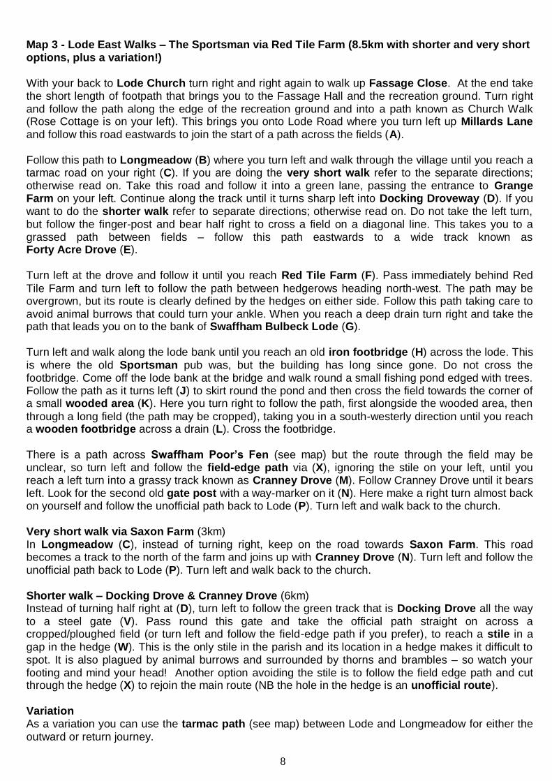
Map 3 - Lode East Walks – The Sportsman via Red Tile Farm (8.5km with shorter and very short options, plus a variation!) With your back to Lode Church turn right and right again to walk up Fassage Close. At the end take the short length of footpath that brings you to the Fassage Hall and the recreation ground. Turn right and follow the path along the edge of the recreation ground and into a path known as Church Walk (Rose Cottage is on your left). This brings you onto Lode Road where you turn left up Millards Lane and follow this road eastwards to join the start of a path across the fields (A). Follow this path to Longmeadow (B) where you turn left and walk through the village until you reach a tarmac road on your right (C). If you are doing the very short walk refer to the separate directions; otherwise read on. Take this road and follow it into a green lane, passing the entrance to Grange Farm on your left. Continue along the track until it turns sharp left into Docking Droveway (D). If you want to do the shorter walk refer to separate directions; otherwise read on. Do not take the left turn, but follow the finger-post and bear half right to cross a field on a diagonal line. This takes you to a grassed path between fields – follow this path eastwards to a wide track known as Forty Acre Drove (E).
Turn left at the drove and follow it until you reach Red Tile Farm (F). Pass immediately behind Red
Tile Farm and turn left to follow the path between hedgerows heading north-west. The path may be overgrown, but its route is clearly defined by the hedges on either side. Follow this path taking care to avoid animal burrows that could turn your ankle. When you reach a deep drain turn right and take the path that leads you on to the bank of Swaffham Bulbeck Lode (G).
Turn left and walk along the lode bank until you reach an old iron footbridge (H) across the lode. This is where the old Sportsman pub was, but the building has long since gone. Do not cross the footbridge. Come off the lode bank at the bridge and walk round a small fishing pond edged with trees. Follow the path as it turns left (J) to skirt round the pond and then cross the field towards the corner of a small wooded area (K). Here you turn right to follow the path, first alongside the wooded area, then
through a long field (the path may be cropped), taking you in a south-westerly direction until you reach a wooden footbridge across a drain (L). Cross the footbridge.
There is a path across Swaffham Poor’s Fen (see map) but the route through the field may be unclear, so turn left and follow the field-edge path via (X), ignoring the stile on your left, until you reach a left turn into a grassy track known as Cranney Drove (M). Follow Cranney Drove until it bears left. Look for the second old gate post with a way-marker on it (N). Here make a right turn almost back on yourself and follow the unofficial path back to Lode (P). Turn left and walk back to the church. Very short walk via Saxon Farm (3km) In Longmeadow (C), instead of turning right, keep on the road towards Saxon Farm. This road becomes a track to the north of the farm and joins up with Cranney Drove (N). Turn left and follow the unofficial path back to Lode (P). Turn left and walk back to the church. Shorter walk – Docking Drove & Cranney Drove (6km) Instead of turning half right at (D), turn left to follow the green track that is Docking Drove all the way to a steel gate (V). Pass round this gate and take the official path straight on across a cropped/ploughed field (or turn left and follow the field-edge path if you prefer), to reach a stile in a gap in the hedge (W). This is the only stile in the parish and its location in a hedge makes it difficult to spot. It is also plagued by animal burrows and surrounded by thorns and brambles – so watch your footing and mind your head! Another option avoiding the stile is to follow the field edge path and cut through the hedge (X) to rejoin the main route (NB the hole in the hedge is an unofficial route).
Variation As a variation you can use the tarmac path (see map) between Lode and Longmeadow for either the outward or return journey.

9
MAP 3
10
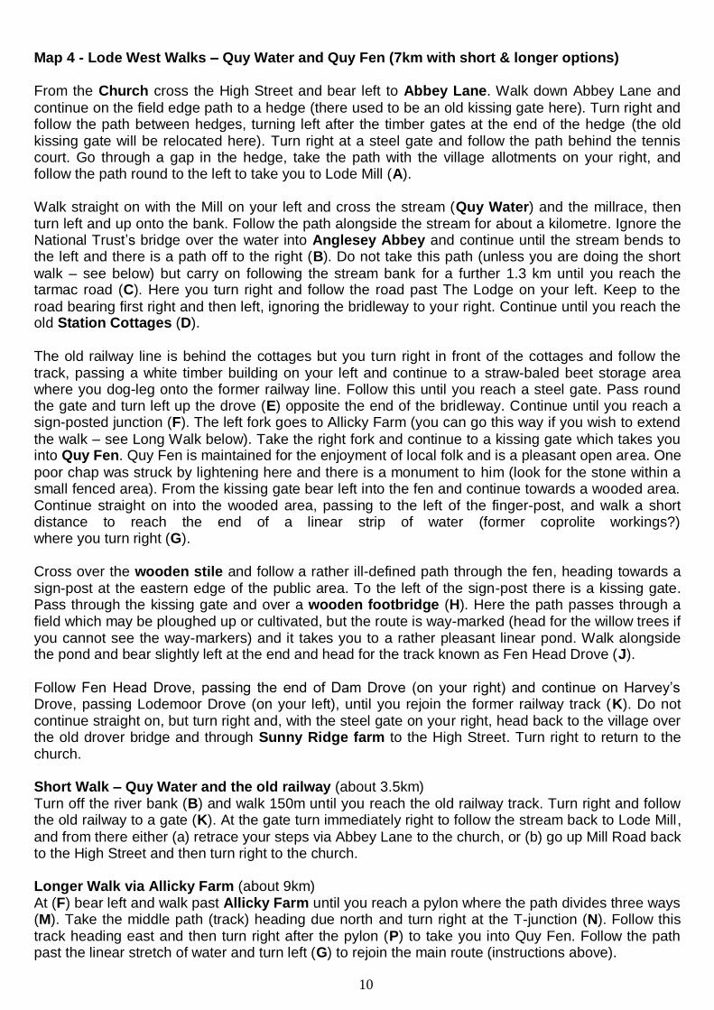
Map 4 - Lode West Walks – Quy Water and Quy Fen (7km with short & longer options) From the Church cross the High Street and bear left to Abbey Lane. Walk down Abbey Lane and
continue on the field edge path to a hedge (there used to be an old kissing gate here). Turn right and follow the path between hedges, turning left after the timber gates at the end of the hedge (the old kissing gate will be relocated here). Turn right at a steel gate and follow the path behind the tennis court. Go through a gap in the hedge, take the path with the village allotments on your right, and follow the path round to the left to take you to Lode Mill (A). Walk straight on with the Mill on your left and cross the stream (Quy Water) and the millrace, then turn left and up onto the bank. Follow the path alongside the stream for about a kilometre. Ignore the National Trust’s bridge over the water into Anglesey Abbey and continue until the stream bends to the left and there is a path off to the right (B). Do not take this path (unless you are doing the short
walk – see below) but carry on following the stream bank for a further 1.3 km until you reach the tarmac road (C). Here you turn right and follow the road past The Lodge on your left. Keep to the
road bearing first right and then left, ignoring the bridleway to your right. Continue until you reach the old Station Cottages (D).
The old railway line is behind the cottages but you turn right in front of the cottages and follow the track, passing a white timber building on your left and continue to a straw-baled beet storage area where you dog-leg onto the former railway line. Follow this until you reach a steel gate. Pass round the gate and turn left up the drove (E) opposite the end of the bridleway. Continue until you reach a sign-posted junction (F). The left fork goes to Allicky Farm (you can go this way if you wish to extend
the walk – see Long Walk below). Take the right fork and continue to a kissing gate which takes you into Quy Fen. Quy Fen is maintained for the enjoyment of local folk and is a pleasant open area. One
poor chap was struck by lightening here and there is a monument to him (look for the stone within a small fenced area). From the kissing gate bear left into the fen and continue towards a wooded area. Continue straight on into the wooded area, passing to the left of the finger-post, and walk a short distance to reach the end of a linear strip of water (former coprolite workings?) where you turn right (G). Cross over the wooden stile and follow a rather ill-defined path through the fen, heading towards a sign-post at the eastern edge of the public area. To the left of the sign-post there is a kissing gate. Pass through the kissing gate and over a wooden footbridge (H). Here the path passes through a field which may be ploughed up or cultivated, but the route is way-marked (head for the willow trees if you cannot see the way-markers) and it takes you to a rather pleasant linear pond. Walk alongside the pond and bear slightly left at the end and head for the track known as Fen Head Drove (J).
Follow Fen Head Drove, passing the end of Dam Drove (on your right) and continue on Harvey’s Drove, passing Lodemoor Drove (on your left), until you rejoin the former railway track (K). Do not continue straight on, but turn right and, with the steel gate on your right, head back to the village over the old drover bridge and through Sunny Ridge farm to the High Street. Turn right to return to the church. Short Walk – Quy Water and the old railway (about 3.5km) Turn off the river bank (B) and walk 150m until you reach the old railway track. Turn right and follow the old railway to a gate (K). At the gate turn immediately right to follow the stream back to Lode Mill,
and from there either (a) retrace your steps via Abbey Lane to the church, or (b) go up Mill Road back to the High Street and then turn right to the church. Longer Walk via Allicky Farm (about 9km) At (F) bear left and walk past Allicky Farm until you reach a pylon where the path divides three ways (M). Take the middle path (track) heading due north and turn right at the T-junction (N). Follow this track heading east and then turn right after the pylon (P) to take you into Quy Fen. Follow the path past the linear stretch of water and turn left (G) to rejoin the main route (instructions above).

11
MAP 4

12
Map 5 - Lode Pub Walks No1 – The Plough and Fleece at Horningsea (10.5km allow 1½ hours each way) From the Church cross the High Street and bear left to Abbey Lane. Walk down Abbey Lane and continue on the field edge path to a hedge (there used to be an old kissing gate here). Turn right and follow the path between hedges, turning left after the timber gates at the end of the hedge (the old kissing gate will be relocated here). Turn right at a steel gate and follow the path behind the tennis court, continue alongside the allotments and then turn left along the path to Lode Mill (E). With the Mill on your left go over the footbridge and then turn left to walk along the lode (Quy Water) for about 1km. Initially you can walk on the bank or at ground level, but keep to the left of the poplars. When you reach the National Trust bridge the path continues along the lode bank. Follow
the path with the lode on your left and woodland on your right. At the end of the wood, where the lode bends to the left, drop off the lode bank and pass through a gate into a field (G).
Follow the field edge path for about 150m until you reach the old railway line (H). Turn left along the
dismantled railway and follow this for about 400m until you are approaching a gate ahead and a large pile of rubble on your left (J). Don’t carry on through the gate, but follow the track round to
your right, noting the dead oak tree on your right. Follow the clearly defined track for 350m until you reach a sign-posted junction (the right fork goes to Quy Fen which we will visit on the return journey). Turn left along the track and continue for a further 400m to Allicky Farm (K). At Allicky Farm keep the buildings on your left and continue on the track until you reach the pylon where the path divides (L). Don’t take the right fork but pass to the right of the pylon and carry straight on across the field. Follow the path passing a raised reservoir on your left. After a little over 1km, ignore the footbridge on your right and instead continue bearing left and cross over the drain at a culvert, passing into a rough field and continue on to the road (M). At the road, turn left and walk through the village of Horningsea. Go past the Crown & Punchbowl and cross the road at a convenient spot. Continue until you reach the Plough & Fleece where you can enjoy a light lunch (N).
After refreshing yourself at the pub, retrace your steps along the High Street and continue out of the village until, after about 1km, you reach a lay-by on the right. Walk into the lay-by (P). Alternatively, to avoid walking along the busy road, you can turn right at M and retrace your steps to the wooden footbridge on your left which you cross to pick up the return route after P. Follow the gravel track (bridleway) sign-posted to Quy. Keep going under the pylons and curve right over the drain. Ignore
the kissing gate on the right and continue to kissing gate ahead. Go through the gate and head to the right of the stretch of water, following it to its end (Q).
You are now in the heart of Stow-cum-Quy Fen where you can roam freely. Bear slightly left and
then right, ignoring the stile and kissing gate on your left, and head for the monument to the unfortunate Mr Ison who was killed by lightning on August 28th 1873. After a pause to reflect on the meaning of life, make for the kissing gate in the eastern corner of the fen and pass over the wooden footbridge (R). The cross-field path may be ill-defined here, but you can head for the near end of a group of willows which fringes a pond. Keep to the right of the pond and, when you reach its end, bear half left across the field to reach the end of a track called Fen Head Drove (S). Follow Fen Head Drove and then Harvey’s Drove until you reach the old railway line. With the steel gate on your right, turn half right to take a track that takes you over the old Drover Bridge through Sunny Ridge Farm and into Lode High Street (T). Turn right onto the High Street and head back to the Church. Notes:
The Plough & Fleece offers bar meals and has plenty of space inside and out. The telephone number is given on the contents page – it is always wise to check opening hours and food availability before setting off.

13
MAP 5

14
Map 6 - Lode Pub Walks No 2 – The Dyke’s End (closed Mondays) at Reach (15km – allow 2½ hours each way) Starting from Lode Church, follow the High Street north-west passing through the village into Station Road. At the edge of the village, just before the speed de-restriction signs turn right down a track between the last two houses (B). This track is not an official right of way but has been well used for many years. At the end turn right (C) onto the grassed track known as Cranney Drove. This takes you past Saxon Farm to the road into Longmeadow. Turn left just before the first house (E) and follow the track past the entrance to Grange Farm (on your left), pass to the side of the metal gate and continue until the track turns sharp left into the grassy lane known as Docking Drove (F). Do not turn into the drove, but follow the finger post direction and bear half right (due
east) to take a diagonal path across the field. Turn half left when you reach the field boundary and continue straight on until you reach a track known as Forty Acre Drove (G).
Turn left here and head towards Red Tile Farm. Before you get to the farm, look for a way-marked path on your right (H). Take this path over a footbridge and continue towards a house until you reach Swaffham Bulbeck Lode (J). Here you can cross the old railway bridge but note that this is not a public right of way. If you choose to cross the bridge turn left to follow the lode bank, otherwise continue along the nearside bank. Both options take you under power lines to a new National Trust timber bridge over the lode. Cross this if you did not cross the lode earlier, walk a little further parallel to the lode, then turn right (K) to take a tarmac road past Slades Farm. Turn right on a tarmac road (L) and head towards the pylons. Turn left on a sign-posted public byway (M). Bear right at the green corrugated iron barns then turn right (N) at the road after the barns and
follow the road round to the left, ignoring the track on your right (Barston Drove – you will return this way if you have the energy!). Continue to follow the road into Reach. The Dyke’s End pub is in the
heart of the village next to the church. Pause for well-earned liquid and solid refreshment (note that the pub is closed on Mondays). When you exit the pub, cross over the village green and turn left to follow the road out of Reach. If you are feeling fit you can do the small extra loop (P-N-Q, instead of P-Q, or you can visit the
Millennium Wood - see Notes). Otherwise continue along the road to the attractive village of Swaffham Prior (call in at the Red Lion if you need refreshment – not open Thursday lunchtime) and on towards Swaffham Bulbeck. Before you get to Swaffham Bulbeck, turn right (R) into Commercial End (more attractive than it sounds). Follow the road (avoiding turning left into the village), pass over Cow Bridge (built in 1927) and carry straight on. When the road bears left (S), turn right towards Red Tile Farm and then immediately left (G) to retrace your steps to the end of Docking Droveway (F). Carry on past the entrance to Grange Farm and turn left into Longmeadow. In Longmeadow you can take one of two paths back to Lode. The first (T) has a tarmac surface and takes you to the recreation ground and thence to Fassage Close which returns you to the church. The second (V) crosses a number of fields and takes you to the end of Millards Lane which you follow and then turn right onto Lode Road and then the High Street back to the church. Notes: You can increase the walk length to 17km by taking a detour to Church Hill. At the edge of the village, just before the speed de-restriction signs (P), turn right up a track. Follow this into a green
lane, ignoring the path to the right. You will reach a field edge at the top of the hill where you turn right. Follow the path which takes you to the road into Reach (N). Turn left (away from the village)
and take the bridleway ahead where the road turns right (sign-posted Devil’s Dyke Walks). This is Barston Drove. Turn right when you reach the road (Q) and follow the road to Swaffham Prior.
Then follow instructions above. If you want to visit the Millennium Wood whilst in Reach take the track between the buildings directly opposite the pub (see map). Bear left behind the building and follow the path.

15
MAP 6

16
Map 7 - Lode Pub Walks No 3 – The Carpenter’s Arms at Great Wilbraham (19km – allow 2½ hours each way) Starting from Lode Church cross the High Street and turn right. After about 150m turn left down Mill Road and continue down to the Mill. Turn right in front of the Mill, cross the footbridge and then turn left to reach the bank of the lode (Quy Water). Follow the lode bank all the way until you reach a road (A). Turn left onto the road, cross the bridge over Quy Water and walk towards Quy village. When you reach the 30mph sign take the path on your right through a kissing gate signposted Church Road ½ mile. Pass through another kissing gate to a field. Ignore the wooden kissing gate on your left and walk along the field edge on the right hand side of a barbed wire fence to reach a pair of metal kissing gates.
Pass through both gates onto a path/track which leads to a wide concrete road. Follow this until you emerge in Quy (B) on the road to Lode. Turn right down Orchard Street and then turn right opposite No9 down a path (old wooden finger-post points the way). Follow the way-marked path left and left again to reach a cross-field path which takes you all the way to Quy Mill car park (C). Turn left and continue until you reach the underpass under the A14 (D).
Continue past the houses on your left until you reach the busy road to Cambridge. Cross this road carefully (there is no particularly safe place but it is best to cross before the crash barriers). Follow the path sign-posted “Wilbrahams via Little Wilbraham River”. This rather insignificant channel is
a tributary of Quy Water. Follow the channel keeping to the right bank, ignoring paths off to the right going to Teversham. Cross the stream at the wide wooden footbridge. Do not continue on the left
bank of the channel (this leads to private land) but bear left to take a path between hedges. Turn left at the track through the farm and continue to Hawk Mill which is now a private house (E).
Go past the house bearing right to Little Wilbraham High Street. Turn right at the Hole in the Wall pub and follow the road to Great Wilbraham and on to the Carpenter’s Arms (PH). After suitable refreshment exit the pub, turn left and walk up the High Street. Go straight ahead at the grass triangle and then turn into Butt Lane (F). Fork left at the Y-junction (G) – you will see pylons in front of you. Cross the Six Mile Bottom road to the right of a pylon (H). Continue on and dog-leg right then left (between hedges) into a wide byway. Turn left at the wooden pylons (J) and onto another wide byway which takes you over the A14 past the rear of a scrap-yard (large dog – chained!) and into a lay-by (K). Turn left and leave the lay-by, cross the road and keep going west towards Bottisham. Turn right (M) to follow the road into Bottisham and continue to the village centre.
When you reach Tunbridge Lane turn right to Bottisham Motors (N) and then cross the road to a
small car parking area (the Pightle). Look for a footpath sign on a lamp-post and follow this tarmac path that takes you to Arber Close. Cross the road and take the path opposite at the near end of the
row of garages. Turn right to follow the path alongside the field, past the sewage works and wood until you reach a steel gate (P) that takes you onto the Lode to Swaffham Bulbeck road. This is
another busy road so cross with care and turn left to follow the roadside path back to the crossroads (R). Turn right into Lode and follow Lode Road into the High Street and back to the church.
Notes:
The scale of the map is rather small so it does not include all the features mentioned in the directions. Judge distances using the scale as an indication of how far each leg is. The walk takes you past three mills - Lode Mill, Quy Mill and Hawk Mill – but only Lode Mill is still milling! It is open to the public (access via Anglesey Abbey – check with the National Trust for opening times). At the time of writing (July 2010) the Carpenter’s Arms has recently been refurbished. They have a restaurant but the bar also serves good bar meals every lunch time (check in advance if in any doubt). See contents page for telephone number.

17
MAP 7

18
Map 8 - Lode Pub Walks No 4 – The No Hurry Inn (Five miles from anywhere) at Upware (20km – allow 3 hours each way) With your back to Lode Church, turn right and right again into Fassage Close. Walk through to the recreation ground and, with the village hall on your left, cross the playing field (go round if in use) to the gap in the hedge where you will find a tarmac path. Follow this all the way to Longmeadow (B). At the road in Longmeadow, turn left then almost immediately right along a farm track, passing
the entrance to Grange Farm on your left, round the metal gate, and continuing until the track turns to the left (C). Do not turn left to follow the track but bear half right to take the diagonal path across
the field, bearing half left when it reaches the field boundary. Continue to the farm track known as Forty Acre Drove (D).
Turn left along the drove and continue on to Red Tile Farm (E). Pass to the left of the farmhouse and turn right immediately behind the building and then turn left to take the path between two hedges (grass may be long on the path). At a deep ditch turn right and mount the bank of Swaffham Bulbeck Lode. Turn left and continue along the lode bank until you reach an old metal footbridge across the lode (G). Go over the footbridge to cross the lode, turn left and continue along the opposite bank. Pass under the two sets of power lines, and go past the new National Trust cycle/horse bridge and shortly afterwards turn right off the lode bank onto a tarmac track. Continue along this track until you reach a T-junction (H). Turn left at the T-junction (you will see a large signboard for Lord’s Ground Farm) and follow the road, bearing round to the right. Ignore the drove on your left which is sign-posted to Lord’s Ground Farm and continue on the road to an offset cross-roads (J). At the cross-roads continue straight on even though Upware is signed to the left. Follow the road, bearing sharp right keeping a bridge over the Commissioner’s Drain on your left. Follow the road to Reach Lode where there is a new bridge (completed August 2010) – (K). Do not cross the lode but turn left to follow the lode bank –
you can mount the bank but you may find the walking easier along the track at the toe of the bank. Follow the lode all the way to Reach Lode Lock (L). Turn right on to the road, go over the bridge and then turn left along a grassy path to the river and the No Hurry Inn (at long last!). Have a nice lunch watching the boats go by (M), and build up your energy reserves for the return journey.
Leave the pub and retrace your steps to the road following it south for a short distance then turn right to join the riverside path. Follow this all the way to Swaffham Lock (N). At the lock, turn left to walk along the bank on the south-west side of Swaffham Bulbeck Lode, following this all the way to the old footbridge (G). Come off the lode bank at the old footbridge and walk round the edge of a small area of water, following the path as it turns left to skirt round the water, and then cross the field to join a field edge path alongside a small wooded area. Turn right to follow this path. At the end of the wooded area the path dog-legs left and right to take you south-west through the middle of a large field to reach a footbridge (Q). Cross the footbridge and continue on another cross-field path across Swaffham Poor’s Fen (or take the alternative route round the field edge if field path is not clear or is very muddy – see map). Rejoin the field-edge path near the start of Cranney Drove (R). Turn left onto Cranney Drove and follow this until you reach a bend to the left (S). At the bend turn hard right to follow a permissive path back to Lode (T). Turn left and walk back to the Church. Notes: This walk is best done in fine weather when ground conditions are dry. The return leg along the Cam is lovely on a nice day. The map has been drawn at a small scale in order to fit on the page so quite a bit of detail is missing. If in doubt as to which way to go, a compass can help to let you know that you are heading in the right direction. You are unlikely to get totally lost but you might want to take a 1:25,000 OS map with you if your sense of direction is not good!

19
MAP 8

20
We aim to keep this walks guide up-to-date so if you find any errors or misleading information on the maps or in the directions, or if you encounter any problems on
the footpaths (obstructions, overgrowing vegetation, missing or broken signs), please let the authors know: