a smart transportation plan for regional development augusta... · a smart transportation plan for...
TRANSCRIPT

THE LAKE AUGUSTA GATEWAY CORRIDOR PLAN
SEDA-COUNCIL OF GOVERNMENTS COMMUNITY RESOURCE CENTER MAY 2012
A SMART TRANSPORTATION PLAN FOR REGIONAL DEVELOPMENT


ACKNOWLEDGEMENTS
Steering Committee MembersJim BakerMatt BeckJan BowmanGretchen BrosiousEd ClarkeTrish CarothersMalcolm DerkJohn DelvecchioJim EisterWes FahringerCory FasoldKen GaydonJim GilfertSteve HermanStacy HinckEd HovenstineShelia HartungJeff HuntCindy InkroteJoe KantzChris KingAlan LichtenwalnerPat MackJulia MaranoEd MarkowskiJoe McGranaghanShawn McLaughlin
Andrew MillerDavid MertzDave MyersFrank NannaSteve PancoeDan RamerTom ReitzDennis RobinsonCharles RossTodd B. RoupFrank SawickiJim SaylorJohn ShipmanJohn ShowersJohn SkotedisTodd SnyderBryan Van SwedenTodd TroxellKim WheelerSkip WiederJesse WoodringRandy Yoxheimer
PennDOT Advisors Anita EverhardBrian HareEric High
SEDA-Council of Governments Team Tom GrbenickBrian AumanAdam WynnKathy HannafordAmy DavisBecky Digan
The Lake Augusta Gateway Corridor Plan is an initiative of the SEDA Council of Governments Community Resource Center. Regional planning for the Lake Augusta gateway corridor was funded through the Pennsylvania Department of Transportation and the Federal Highway Administration. The plan was developed with public input and with the assistance of diverse public-private stakeholders representing local and county governments; local and regional organizations; area residents, business and property owners; and state and regional agencies. For more information please contact:
Tom Grbenick, Director Community Resource Center
SEDA Council of Governments 201 Furnace Road Lewisburg, PA 17837


TABLE OF CONTENTSA Call to Action
Regional Development Opportunity
About the Plan
Community Character And Context
A Regional Vision
Smart Transportation Solutions
The Smart Transportation Plan
The Action Strategies
Organizing The Gateway Community
Afterword
Appendix
SELECTED REFERENCESPAGE1
3
9
13
39
41
67
93
125
129
133
North Central PA Public Transportation Needs Assessment; Gannett-Fleming, Inc.; 2011.
Coming Together—Sunbury’s Plan for the New City; SEDA-COG Community Resource Center; 2011.
Susquehanna River Sports Park Feasibility Study; SEDA-COG Community Resource Center; 2010.
Fixed Transit Study—Sunbury Transit Feasibility Study Final Technical Memorandum; Michael J. Baker; 2009.
Valley Vision 2020—A Plan for Pennsylvania’s Heartland; SEDA-COG Community Resource Center; 2008.
Central Susquehanna Valley Thruway Transportation Study; SEDA-COG Community Resource Center; 2007.
Northumberland County Comprehensive Plan; 2005
Lower Anthracite Transportation System Fixed Route System
FIGURES
Figure 1 — Regional Attractions
Figure 2 — Regional Location Map
Figure 3 — Lake Augusta Gateway Community
Figure 4 — Aerial View Lake Augusta Gateway Corridor
Figure 5 — Regional Zoning Map
Figure 6 — Regional Land Use Map
Figure 7 — Lake Augusta Gateway Corridor Master Plan
Figure 8 — Roadway Categories
Figure 9 — Defining Contexts
Figure 10 — Key Map to Roadway Sections
Figure 11 — Standard Functional Highway Classification Scheme
Figure 12 — Existing Smart Transportation Classification Scheme
Figure 13 — Proposed Smart Transportation Classification Scheme
Figure 14 — RiverLink Concept Diagram
5
13
13
15
34
36
39
44
44
45
64
65
66
69


1LAKE AUGUSTA GATEWAY CORRIDOR
Building Regional Identity in the Middle Susquehanna Valley
Over the past decade we have seen the continued emergence of new ideas for living, working, and playing in the Middle Susquehanna Valley. Plans have been laid locally and regionally to build a better tomorrow in the Lake Augusta gateway area connecting Sunbury, Northumberland and Shamokin Dam.
Sunbury’s Plan for the New City sets forth a compelling vision for new urban living focused on its place-based assets—assets like the Susquehanna riverfront, its historic downtown and neighborhoods, and its proximity to recreational amenities at Lake Augusta and Shikellamy State Park.
Regional institutions of higher learning have invested in new research and education facilities at Shikellamy Marina. Plans have been advanced for the development of a river sports park and boathouse at Routes 11-15 and a migratory fish passage at the Adam T. Bower Memorial Dam in Shamokin Dam.
LAKE AUGUSTA GATEWAY CORRIDORA CALL TO ACTION

2 LAKE AUGUSTA GATEWAY CORRIDOR
Regional communities have joined forces to explore ideas and strategies for connected river town development. Proposals have been advanced for state Heritage Area designation and new projects continue to shape the Susquehanna Greenway experience.
On an even broader scale, SEDA-COG’s 11-county regional plan, Valley Vision 2020, targeted the Lake Augusta gateway area as one of the region’s top areas for sustained public-private investment—a regional community and visitor destination which capitalizes on the locational advantages, recreational and environmental assets of the Susquehanna confluence area.
Future Vision for Lake Augusta Gateway Communities
Lake Augusta is in the eyes of many an underdeveloped community and regional asset. The future use and enjoyment of this resource and the economic development of the communities connected along its urbanized shoreline requires new vision, action strategies, and the alignment of public-private development interests and investments.
The future will place new burdens on the area’s transportation system. But it will also create new opportunities for building an even more functional and efficient system—a Smart Transportation system to compliment, enable, and accommodate desired development in the future. Smart transportation is all about linking land use and transportation planning to create great places.
We have an opportunity to chart this course and to shape a future development agenda for the Lake Augusta gateway region. This plan—The Lake Augusta Gateway Corridor Plan—is the beginning of a multi-faceted and multi-phased approach to smarter growth and smart transportation in the region. It lays groundwork for building an effective transportation network, a network of systems to serve community and regional needs well into the future.
Integrating Transportation, Land Use and Economic Development
This plan is focused on achieving results which stem from contemporary planning philosophies and development models for both smart growth and smart transportation. It provides direction that communities in the gateway region can use to enhance their individual and collective prospects.
Because transportation planning, design, and development permeate all aspects of community and economic development it is perhaps the most logical place to begin. This effort has focused largely on understanding and advancing the implementation of PennDOT’s Smart Transportation idea in the context of a regional community.
Municipal governments can and must become better partners with PennDOT and others in shaping the regional transportation system. Active and constructive engagement with PennDOT will achieve results that work for the area, that fit the community and environmental context of the area, that meet the widest possible range of land use and transportation objectives, including those relating to alternative transportation modes such as walking, bicycling, and public transit.
Special thanks are due to the many stakeholders who contributed to this planning process and to forging a new vision for the area and its transportation system. Through organization and ensuing public-private action the Lake Augusta gateway region is poised to make its mark and realize its fuller potential for living, working, and visiting.

3LAKE AUGUSTA GATEWAY CORRIDOR
Transportation Development in the Lake Augusta Gateway Corridor
Transportation investments shape the prominence of communities, their social vitality and economic prosperity. Today as in the past, for better or for worse, the impact of transportation systems and technologies is of fundamental importance to community and economic development.
Communities in the Lake Augusta gateway area benefit from a modern transportation system. But the system’s ability to address access, mobility and safety is not unstressed. And the ability of the present system to meet future needs will be increasingly challenged as local populations shift, grow and settle; as communities build; and as recreation and tourism attracts even more visitors to the Susquehanna River—River Town—Lake Augusta experience.
The development of Lake Augusta perpetuates the region’s history as a destination for transportation-connected settlement and economic activity. Great Native American footpaths and trails converged at the trading site of Shamokin in present day Sunbury. Early wagon roads in the 18th and early 19th centuries followed the course of the river. Ferry boats moved people and freight from place to place well before the development of bridges. Later in the 19th century Canals and railroads boosted manufacturing and population growth. Inter-urban trolleys, passenger railways, and modern highways and bridges made the
region markedly more accessible to markets and visitors over the 20th century.
Through it all, people have connected to communities via their downtowns and neighborhoods—urban places connected by a well-developed network and hierarchy of humanly scaled and gridded streets, alleys, sidewalks and crossings. Regional transit connections opened outlying areas to new development for work and commerce.
Somewhere in the course of this advancement, however, we lost our focus. We built our communities almost exclusively to accommodate the passage and parking of motor vehicles and frequently to the detriment of other transportation modes such as walking and bicycling. What was once natural and fundamental to daily living is now more often relegated to the status of a “transportation enhancement”.
Regional Character and Identity
The urban communities comprising the Lake Augusta gateway corridor and their connecting countryside exude a particular regional character that is noteworthy and worthy of preservation and betterment in connection with the area’s future development. They share common riverfronts that enable public use and enjoyment of Lake Augusta. They share a distinctive sense of place marked by the confluence of the Susquehanna River main stem with its branches. Here, the River becomes more mighty and prominent on its final run to the Chesapeake Bay.
LAKE AUGUSTA GATEWAY CORRIDORA REGIONAL DEVELOPMENT OPPORTUNITY

4 LAKE AUGUSTA GATEWAY CORRIDOR
This sense of place—this regional character and identity—is fundamental to the success of gateway communities like Sunbury, Northumberland and Shamokin Dam. Just as the region’s transportation system is of paramount importance to shaping the highest and best mix of human and economic activity in years to come. Transportation planning has the potential to add or detract from regional life, commerce, and economic development. In promoting smart approaches to regional growth and transportation design and development, it is possible to build the future transportation system in ways that preserve and enhance existing places while meeting local and regional needs for the movement of people and goods safely and efficiently.
Transportation design and development affects each gateway community in similar yet differing ways. Each presents its own challenges and opportunities as a fact relating to place location and past judgments, decisions and actions. As an urban system real challenges must be addressed to preserve the essential goodness of places and enhance their use and enjoyment by residents and visitors. This is best achieved through wise municipal and intergovernmental decisions and through coordinated public-private action.
A Targeted Investment Area
Lake Augusta is a core and common asset of the Middle Susquehanna Valley—an environmental asset consisting of river towns, the river, and the encompassing landscape. Lake Augusta is an asset open to wide public use and enjoyment—for regional residents and visitors alike. It has the potential to foster active living and healthier lifestyles and communities. Tying it all together is the regional transportation system for motor vehicles, bicycles, pedestrians and potentially public transit.
Figure 1—Lake Augusta Regional Attractions illustrates but a small fraction of the region’s historic, cultural, and recreational attractions. When other assets such as parks, schools, and businesses are mapped the extent of the area’s traffic-generating activity is immediately
apparent. Commonly recognized transportation assets in the study area include US Routes 11 and 15, PA Routes 147 and 61, and Bicycle PA Route J. Other transportation assets include the aforementioned network and hierarchy of streets, alleys, sidewalks and crossings, the regional rail system and even a private airstrip landing on Packer Island.
Recognizing the singular importance of these assets and attractions to the larger Central Pennsylvania region, the Lake Augusta Gateway corridor is also recognized as one of several potential “targeted investment areas” identified in Valley Vision 2020—The Plan for Pennsylvania’s Heartland. In this regard, it is recognized that the Lake Augusta gateway corridor presents multiple development challenges and opportunities of importance to a wider region and is recognized as a viable location for coordinated public-private investment.
Valuing the Region’s Sense of Place
Lake Augusta is the most visible environmental asset in the urbanized Middle Susquehanna Valley and also its most undervalued. As a regional place and recreation attraction it provides needed impetus for community and economic development within a gateway corridor marked by a mix of urban neighborhoods, historic and cultural landmarks, and riverfronts set against a memorable natural and scenic landscape.
As a place and an idea, Lake Augusta has barely realized its true potential. The gateway corridor focuses on the confluence of rivers and human activity-and-on the man-nature connection in an otherwise urban setting. Riverfront projects planned and now under development can build upon the area’s sense of place—can celebrate and foster a sense of place that underlies the area’s attraction.

5LAKE AUGUSTA GATEWAY CORRIDOR
Figure 1—Lake Augusta Regional Attractions

6 LAKE AUGUSTA GATEWAY CORRIDOR
To do so, first requires communities to understand and value their character-defining features and to preserve and enhance these features through public policy aimed at fostering smart growth. But it also requires public-private commitments and partnerships aimed at building a smart transportation system for the future. A system that is multi-modal and balanced. A system that builds consistently and sustainably on the themes and principles of smart transportation design and development espoused in The Lake Augusta Gateway Corridor Plan.
A Vision for Smart Growth and Transportation
We have a significant opportunity in The Middle Susquehanna Valley—an opportunity to change the face of our region and to improve its prospects for future generations—to shape the character of our area and our economic prospects not by happenstance and chance but decidedly through a shared vision and coordinated action.
This will take time to organize and materialize. It will be easier to ignore this opportunity than to pursue it. But to do so will rob future generations of the promise our region holds and to ignore one of our area’s single most important assets.
Lake Augusta is that opportunity. It provides a focal point and stimulus for community revitalization, river-based recreation, and environmental conservation projects and activities connecting the area’s riverfront communities via the evolving Susquehanna Greenway. It is a shared resource common to the area. It doesn’t pit one locale or one project against another. It broadens opportunity for all by creating a bigger pie from which all may partake. It can be used to build a sense of community within the larger region—community building to transform the region in other ways yet imagined or considered.
The Lake Augusta Gateway Plan establishes ideas for connecting existing and proposed riverfront development and related Greenway gateway concepts through “Smart Growth” and “Smart Transportation” design and development as part of a larger targeted investment plan for the region.
As conceived, Lake Augusta Gateway development will stimulate interest in the area’s place-based assets and its related social, economic, and environmental advantages. It will enhance awareness of the Susquehanna River Valley, our distinctive river towns, and the Susquehanna Greenway connection. It will pursue new opportunities for active living, recreation, and environmental conservation. It will lead to fuller use and enjoyment of the Susquehanna River by residents and visitors and it will enhance investments in waterfront-connected development.
Building on a Foundation of Principles and Integrated Actions
Achieving the regional vision for Lake Augusta presents a real and present challenge to the status quo—to our standard approaches to community and economic development and transportation planning. To reach our broader aims we must build on a principled foundation and work from a playbook of integrated actions. Acknowledging this, The Lake Augusta Gateway Plan articulates principles for intergovernmental and public-private consideration.
By following the overarching themes and principles of smart growth and smart transportation we can maintain the livability and attraction of river towns deemed important to regional prosperity while building a transportation system in synch with the character of the region’s traditional towns and neighborhoods , its special places and landscapes—the places and spaces essential to asset- and place-based development.

7LAKE AUGUSTA GATEWAY CORRIDOR
Transportation Investments and Organizational Development
The Lake Augusta Gateway Corridor Plan identifies a mix of transportation projects for incorporation into the region’s broader transportation plan—investments and enhancements to improve motor vehicle, bike and pedestrian access, mobility, and safety—investments to foster local and regional development relating to Lake Augusta and the Susquehanna riverfront, including streetscape and highway corridor enhancements, greenway-trailways, scenic parkways, and intersection enhancements.
Implementing The Lake Augusta Gateway Corridor Plan is necessarily a long term undertaking. But it can begin now by pursuing some of the short term projects identified in the action strategies. To achieve the region’s vision for transportation and growth it will require a sustained commitment to inter-community organization and action.
Regional organization and organizational development is basic to advancing the vision, principles, goals, development proposals, and action strategies embodied in the Plan. Regional organization is needed to promote the continued development of Lake Augusta and to foster regional intergovernmental and public-private collaboration on asset- and transportation-based development.

8 LAKE AUGUSTA GATEWAY CORRIDOR

9LAKE AUGUSTA GATEWAY CORRIDOR
The RiverLink Concept
The concept embodied in the merged word RiverLink is played out daily in towns and cities around the nation. In the Middle Susquehanna region, we look to the Susquehanna River as a place to renew our spirits and a conduit to understanding our past and formulating our future. Our closely spaced river towns are linked by the River and share both the pleasures and the pains of the river setting.
In Looking to the River, an original documentary film produced by WVIA Public TV, we learn that “The Susquehanna River has always drawn humans to its banks and to its basin in search of life. For ten thousand years, man’s imagination and imperfection have entwined with nature’s irresistible forces to create a human and natural history that relentlessly shapes this river and the lives of those who reside near it. And as it has always been, so is it today that we look again to the Susquehanna to nurture our aspirations and dreams.”
In the many miles of riverfront shores from Lake Otsego in Cooperstown New York to Havre de’ Grace in Maryland at the mouth of the Chesapeake Bay, there is nothing that quite compares with the attraction of Lake Augusta at the river confluence. Here we enjoy a wide variety of water-based activities—a connected outdoor recreation experience set within a memorable multi-river town landscape.
The Lake Augusta Gateway Corridor Plan is a bold step in a new direction for the region. It aims to enhance community and environmental assets through smart growth and to connect the Lake Augusta Community through smart transportation design and development. In embarking on this voyage, the Plan—like the RiverLink concept—looks to merge a regional vision and big-picture thinking with community- and environment-enhancing transportation projects for the future.
The Purpose of the Plan
On a broader scale, The Lake Augusta Gateway Corridor Plan proffers direction to better link public-private investment for community and economic development, environmental enhancement, and most importantly, for transportation system design and development. More specifically, the Plan proposes transportation solutions for access, mobility, safety and modality projects in gateway corridor communities. Said yet another way, the Plan proposals illustrate ways to enhance community prospects through integrated, functional and context-sensitive system design.
The advocated methodology has gained traction under the banner of smart transportation. It is smart because it tailors solutions to the community context. It tailors the approach to specific projects. It engages community stakeholders in the process of system design and development. It plans for alternative transportation modes such as walking and bicycling. It uses sound judgment to evaluate choices and make decisions. And it scales transportation solutions to the size of the problem.
LAKE AUGUSTA GATEWAY CORRIDORABOUT THE PLAN
The Planning Approach
The gateway corridor plan provides guidance to address area wide challenges and opportunities keyed to transportation, recreation, environmental enhancement, community revitalization and economic development initiatives.

10 LAKE AUGUSTA GATEWAY CORRIDOR
The plan was developed in conformance with the following approach:
1. Organize stakeholders for Lake Augusta gateway corridor development. A mix of stakeholders representing a range of public-private interests was convened to provide a sounding board for Plan development.
2. Assess existing community needs and conditions. Transportation, economic development, community revitalization and environmental enhancement needs were identified with community input.
3. Develop a future vision for the gateway corridor. A shared future vision for the Lake Augusta gateway community establishes the context for smart transportation system development, future land use, economic and community development.
4. Educate gateway corridor communities on Smart Growth and Smart Transportation principles. Principles were articulated to guide public-private investment in transportation projects, community design and environmental enhancement relating to gateway corridor development.
5. Develop a Smart Transportation concept for the gateway corridor. A regional transportation concept was developed to address transportation barriers and opportunities relating to traffic movement and safety, public sites access and parking, bicycle and pedestrian travel.
6. Develop strategies to foster gateway corridor investment. Direction was recommended to build and enhance the urban Lake Augusta waterfront using integrated transportation, community and economic development strategies to promote public-private collaboration in a targeted investment plan for regional development.
7. Stimulate public-private interest and investment in transportation system enhancements through organizational
development. Organizational models were examined and recommendations were proposed for a permanent organizational arrangement to foster regional cooperation and plan-implementation.
Guidelines and Standards Considered
The Lake Augusta Gateway Corridor Plan responds to the general guidelines of PennDOT’s Smart Transportation Guidebook and to The Charter of the New Urbanism advocated by the Congress for the New Urbanism in addition to other priority focus areas identified in related county and municipal plans and ordinances.
Other state and regional plans referenced in the development of The Lake Augusta Gateway Corridor Plan include: 1) Commonwealth Keystone Principles for Growth, Investment and Resource Conservation, 2) Valley Vision 2020 – A Plan for Pennsylvania’s Heartland, and 3) The Susquehanna Greenway Strategic Plan.
11LAKE AUGUSTA GATEWAY CORRIDOR
Public Participation—Creating an Informed and Involved Community
Transportation, community and environmental advocates helped to develop The Lake Augusta Gateway Corridor Plan. Varied means and methods were used to obtain balanced input in the process and to lay groundwork for organizing and implementing the plan. Stakeholders were involved through task force meetings, focus group and key person interviews, and open-invitation workshops and public meetings. The project was covered periodically by local news media. Special briefings were scheduled with local government officials.
The Steering Committee
A steering committee of nearly 40 individuals contributed to Plan development. Principal committee stakeholders included SEDA-COG, the Susquehanna River Valley Visitors Bureau, Greater Susquehanna Valley Chamber of Commerce, Susquehanna Greenway Partnership and the PA Heartland Coalition; the PA Bureau of State Parks, the PA Historical and Museum Commission, and the PA Department of Transportation; Union, Snyder and Northumberland counties; the City of Sunbury, Shamokin Dam and Northumberland boroughs, Union, Monroe, and Upper Augusta townships; Bucknell and Susquehanna university rowing programs, the Central PA Rowing Association, the Northumberland Boat Club, Sunbury Community Hospital, The Northumberland County Historical Society, and other private institutions, organizations, and businesses.
Key Person and Focus Group Interviews
Ten Key person interviews and eight focus group interviews were conducted to obtain additional background information and insights needed for plan development. Interviews were conducted with present and former county and municipal officials; business, environmental, and community organization leaders and affiliates; and key private property and business owners. Focus group participants helped test Plan proposals and focus group findings were considered in shaping Plan action strategies.
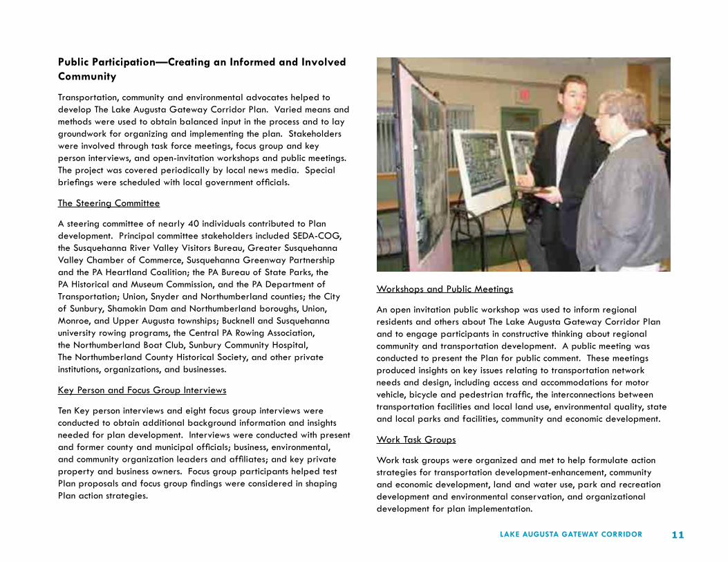
Workshops and Public Meetings
An open invitation public workshop was used to inform regional residents and others about The Lake Augusta Gateway Corridor Plan and to engage participants in constructive thinking about regional community and transportation development. A public meeting was conducted to present the Plan for public comment. These meetings produced insights on key issues relating to transportation network needs and design, including access and accommodations for motor vehicle, bicycle and pedestrian traffic, the interconnections between transportation facilities and local land use, environmental quality, state and local parks and facilities, community and economic development.
Work Task Groups
Work task groups were organized and met to help formulate action strategies for transportation development-enhancement, community and economic development, land and water use, park and recreation development and environmental conservation, and organizational development for plan implementation.

12 LAKE AUGUSTA GATEWAY CORRIDOR
` Development of a river sports park for non-motorized boating (rowing, canoeing, kayaking), related training, and regatta event programming.
` Increased business opportunities for boat sales and water recreation equipment.
` Visitor facilities constructed for Susquehanna Greenway gateway communities (Sunbury, Northumberland, Shamokin Dam and other regional river towns).
` Potential for scenic parkway and streetscape construction around Lake Augusta.
` Fish passage established for migratory sport fishing and sight-seeing.
` Enhance access to The Susquehanna River Environmental Studies Center at Shikellamy State Park Marina building for university sponsored environmental research.
` Enhanced property values and stronger county and municipal tax base.
` Greener environment and reduced air pollution.
` Increased traffic safety and a safer environment for pedestrians and bicyclists.
` Enhanced opportunities for exercise, fitness training, and active healthy living.
` Improved image and identity for adjoining residential neighborhoods through enhanced marketing of Lake Augusta attractions.
` New public-private partnerships, including collaboration among state, county and municipal governments for regional economic development and community revitalization.
Plan Results and Benefits
The Lake Augusta Gateway Corridor Plan will stimulate regional interest and investment in projects to serve community needs and attract regional visitors. It will enhance awareness of the Susquehanna Greenway and the natural, cultural and historical assets of real importance to river town development. It will foster interest in active living, transportation, recreation, environmental conservation, community revitalization and economic development. It will enhance the return on municipal, county, and state investments in waterfront parks and access facilities and will lead to fuller use and enjoyment of Lake Augusta by area residents and visitors.
Here are some of the specific benefits envisioned as an outcome of Plan implementation:
` New construction jobs for street, roadway, and riverfront trail development and related environmental enhancements.
` Enhanced highway safety and flood hazard reduction.
` New hotel and restaurant investment and jobs to serve regional visitors.
` Expansion of Shikellamy State Park around the six mile perimeter of Lake Augusta waterfront.
` More use and higher return on investment for existing state-owned parks, historic sites, and river access facilities.
` New jobs for park rehabilitation, development, operations and maintenance.
` New private investment in park and riverfront related housing and business development.
` New opportunities for public use and enjoyment of the river and riverfront.

13LAKE AUGUSTA GATEWAY CORRIDOR
Lake Augusta
Lake Augusta is formed by the Adam T. Bower Memorial Dam, the world’s largest inflatable dam, located at Sunbury-Shamokin Dam. Lake Augusta is located at the heart of the Middle Susquehanna region. It enjoys ready access from Interstate, state and local highway routes and is within easy driving distance of larger population centers such as State College, Williamsport, Harrisburg, Lancaster, Reading, and Wilkes Barre. It attracts visitors from locally and beyond.
Since becoming operational in the 1970’s Lake Augusta has grown as a regional destination for water-based recreation, sports and fishing. The Lake is a community and environmental asset shared among three counties and seven municipalities, each with their own views, plans and regulating methods.
It extends nearly 3 miles in length, about one half mile in width, with over 6 miles of connected riverfront shoreline and roadways. The area includes four motor vehicle and two railroad river bridges which connect the gateway communities of Northumberland, Sunbury, Shamokin Dam and adjoining segments of Monroe, Point, Union, and Upper Augusta townships.
Lake Augusta and its connected river towns provide superb opportunities for outdoor recreation, river town shopping, museum visitation and historic site touring. In combination, the River and its towns attract diverse populations for motorized and non-motorized boating, picnicking and sightseeing, seasonal camping, walking and bicycling, riverfront and town entertainments, events and activities.
LAKE AUGUSTA GATEWAY CORRIDORCOMMUNITY CHARACTER AND CONTEXT
Figure 2—Regional Location Map Figure 3—Lake Augusta Gateway Community

14 LAKE AUGUSTA GATEWAY CORRIDOR
Past state investments in the Fabridam, Shikellamy State Park and river access areas mixed with other municipal investments in riverfront parks have opened the door to further development possibilities, including the proposed Shamokin Dam fish passage and Susquehanna River Sports Park, and the Susquehanna Heartland Environmental Research and Education Center currently under development.
Large extents of the Lake Augusta urban area shoreline, however, remain underdeveloped or otherwise inaccessible to the public. Public desire knows no limits with respect to river access and rising use of available parks suggests that both the opportunity and the market exist for more intense use by boaters, anglers and sightseers. Meeting these needs will require the continued expansion of connected riverfront access points, linear parks and trails—The Lake Augusta Gateway Corridor Plan builds from this tangible evidence and assumption.
The Lake Augusta Gateway Community
The Lake Augusta Community considered in The Lake Augusta Gateway Corridor Plan consists of 7 gateway communities: 1) Sunbury City, 2) Upper Augusta Township, 3) Point Township, 4) Northumberland Borough, 5) Union Township, 6) Monroe Township, and 7) Shamokin Dam Borough.
The gateway community orients to the confluence of the Susquehanna River and its West and North Branches. From the Blue Hill ridge opposite Sunbury it’s easy to see the beauty of the place—the River, Packer Island, Sunbury—the River City—historic Northumberland and Shamokin Dam, all close to the region’s surrounding countryside. What is especially distinguishing about this place is its confluence purpose. It is a place where transportation, rivers and towns, history, parks and commerce come together. It is the focus of everyday life for thousands living in the region.
Aerial View of the Lake Augusta Gateway Corridor
These communities share a common experience. They share common interests relating to community and economic development. And they share responsibilities for municipal components of the region’s larger transportation network. Over time and in varied ways each has joined forces with one or another to address matters of plain importance and mutual concern—neighbors helping neighbors—mutual aid and shared municipal services—common institutions and organizations.
Today, perhaps more than at any time in the past, there are innumerable opportunities and reasons to pursue regional attachments—to build a regional image, identity and community. Doing so does not diminish the heritage, autonomy, or prospects of the locale. On the contrary—regional coordination and collaboration can build new prospects and prosperity for the area from which all may benefit.
Transportation system development is a logical place to begin as the integration of transportation assets is basic to local-regional development in the gateway corridor. Building a better transportation system for the future—a smart transportation system—requires coordinated development planning, intergovernmental cooperation and collaboration, and organization on a regional scale to fund and implement the region’s transportation goals and strategies.
Moving regionalism from theory to practice works best where a sense of regional community exists or where it can reasonably and realistically be developed. The Lake Augusta Gateway Corridor Plan makes a strong case for regional community building because many ingredients essential to regional action are already in place. It opens the door to regional organization for smart growth and transportation system design and development.

15LAKE AUGUSTA GATEWAY CORRIDOR
Figure 4—Aerial View of the Lake Augusta Gateway Corridor
Figure 3—

16 LAKE AUGUSTA GATEWAY CORRIDOR
Regional Attractions
Wide-ranging attractions draw visitors to the area. Some of these are illustrated in the adjoining map. This map only scratches the surface of possibilities. It shows that tourism has a potentially significant impact on new business development and jobs and reminds us about the need for Lake Augusta focused promotion within and beyond the area. The word cloud illustrates a range of community and environmental assets that contribute to the area’s appeal.

17LAKE AUGUSTA GATEWAY CORRIDOR

18 LAKE AUGUSTA GATEWAY CORRIDOR
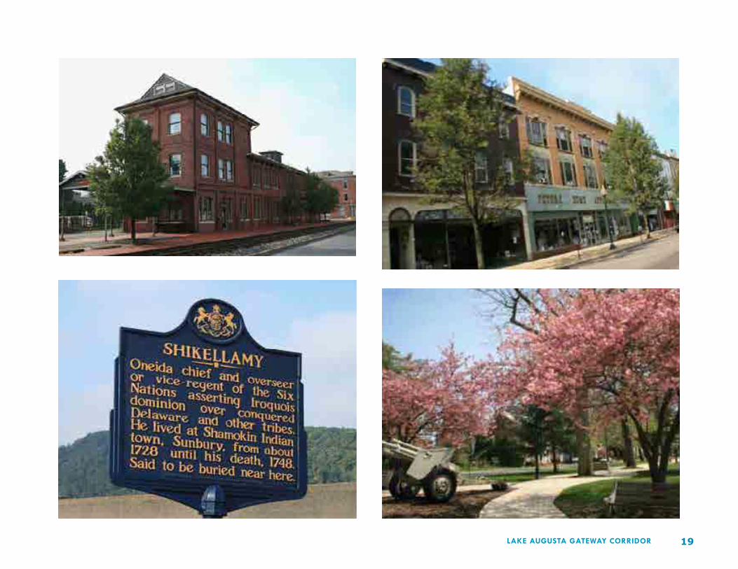
A Sense of Place
The Lake Augusta gateway region exudes environmental character that is regionally distinct and memorable—an organic blend of river towns, ridge and valley vistas, and island landscapes—providing intimate glimpses into nature and the area’s cultural traditions and heritage. These assets of place are the foundation for next generation environmental enhancement, civic and economic betterment, and transportation connections.
We all have different perspectives on Lake Augusta. For many people it’s a destination for boating and fishing activities—perhaps a sought-after location for riverfront camping—or just something nice to look at as we go about our daily activity. For others, it’s also about the historic communities connected to its shoreline—the man-made features and assets like those illustrated.
19LAKE AUGUSTA GATEWAY CORRIDOR

20 LAKE AUGUSTA GATEWAY CORRIDOR
Natural Assets
The gateway corridor is also endowed with a blend of truly special natural assets—some readily observable from common vantage points—others not so obvious. It’s the interplay of these natural and man-made assets in such close proximity—in an urban setting—that gives Lake Augusta its special sense of place. And that sense of place is part and parcel of its appeal and its attraction. Only now are we beginning to realize how this appeal can be turned to broader economic advantage for the region.

21LAKE AUGUSTA GATEWAY CORRIDOR
Roadway Character
Northumberland-Sunbury
Sunbury and Northumberland are the earliest settled communities in the Lake Augusta gateway community. They are linked by PA Route 147 which parallels the east shore of the Susquehanna River and connects to the Interstate 80-180 junction near Milton and to the US 22-322 junction north of Harrisburg. PA Route 61 connects Sunbury with Reading through the Lower Anthracite region of Northumberland County.
The land use context and character of state routes 147 and 61 varies markedly from place to place and presents differing opportunities and challenges relating to river and recreation facility access, traffic mobility and safety. Duke Street in Northumberland Borough (Route 147) has evolved into a modern day commercial strip wedged between the Norfolk Southern rail yard to the west and residential Northumberland to the east.
Duke Street is routinely congested with local and regional traffic, including through motor freight trucks. Traffic back-ups at the intersection of Routes 147 and 11 are an irresolvable part of everyday life in Northumberland owing to a combination of factors—sheer traffic volumes, railroad and riverfront related limitations, and the town’s historic settlement patterns.
Duke Street (PA 147), Northumberland

22 LAKE AUGUSTA GATEWAY CORRIDOR
Water Street (US 11), Northumberland

23LAKE AUGUSTA GATEWAY CORRIDOR
Sunbury and Northumberland are joined via the Route 147 crossing over Packer Island in Upper Augusta Township. Bridge Avenue (Route 147) is lined with a mix of commercial, light industrial and residential development. While it retains the feeling of a residential street its potential for multi-modal use is much compromised by heavy motor vehicle traffic volumes.
The opportunities for walking and bicycling on Packer Island are especially significant, including the potential for connecting links to Sunbury and Northumberland. Sidewalks are located on the upstream sides of both island bridges but there are no safe links to Shikellamy State Park for bicyclists and pedestrians.
Bridge Avenue (PA 147), Packer Island
Packer Island remains a world unto itself—neither Sunbury nor Northumberland—the island is a recreational haven today much as it was historically. The presence of Shikellamy State Park and Marina, the Sunbury Social Club, and several waterfront campgrounds makes this a desired destination for both recreation and residence.
Bridge Avenue (PA 147), Point and Upper Augusta Townships

24 LAKE AUGUSTA GATEWAY CORRIDOR
PA 147 Packer Island at the Confluence
25LAKE AUGUSTA GATEWAY CORRIDOR
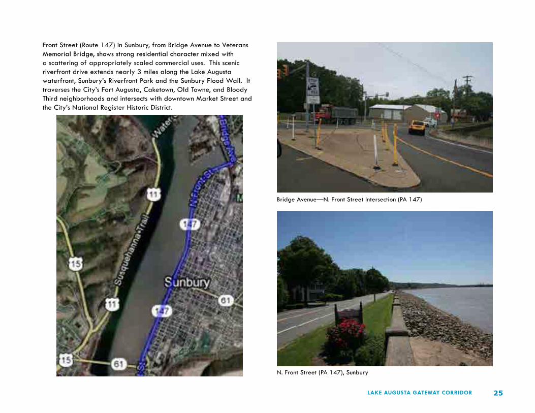
Front Street (Route 147) in Sunbury, from Bridge Avenue to Veterans Memorial Bridge, shows strong residential character mixed with a scattering of appropriately scaled commercial uses. This scenic riverfront drive extends nearly 3 miles along the Lake Augusta waterfront, Sunbury’s Riverfront Park and the Sunbury Flood Wall. It traverses the City’s Fort Augusta, Caketown, Old Towne, and Bloody Third neighborhoods and intersects with downtown Market Street and the City’s National Register Historic District.
Bridge Avenue—N. Front Street Intersection (PA 147)
N. Front Street (PA 147), Sunbury

26 LAKE AUGUSTA GATEWAY CORRIDOR
Sunbury has a well-developed grid of streets and sidewalks that serve bicycle and pedestrian needs. Pedestrian conflicts with motor vehicles are minimized through the use of signalized street intersections and defined crosswalks. However, improvements to Riverfront Park have increased demand for riverfront access and more crosswalk safety improvements are needed to serve bike and foot traffic connecting to Riverfront Park and the Lake Augusta riverfront.
N. Front Street (PA 147), Sunbury
S. Front Street (PA 147), Sunbury

27LAKE AUGUSTA GATEWAY CORRIDOR
Sunbury-Shamokin Dam
Sunbury and Shamokin Dam are joined by Veterans Memorial Bridge (Route 61) located upstream of the Fabridam. This is a conduit for regional traffic in and out of Sunbury and a destination for riverfront access on both the east and west river shores. Pedestrian and bicycle crossing is accommodated via a sidewalk on the downstream side of the bridge which connects to street walks in both communities.
Demand for recreational use of riverfront park and access lands adjacent to the bridge interchanges is significant. Private boat access and docking is available from Route 11 upstream of the Veterans Memorial Bridge. Public access for river boating is provided by the Pennsylvania Fish and Boat Commission from Route 147 immediately below the Fabridam on the River’s east shore.
Fabridam Access in Shamokin Dam
PA Route 61, Sunbury-Shamokin Dam

28 LAKE AUGUSTA GATEWAY CORRIDOR
Veteran’s Memorial Bridge (PA 61), Sunbury-Shamokin Dam

29LAKE AUGUSTA GATEWAY CORRIDOR
Northumberland-Shamokin Dam
The Susquehanna Trail (Route II) between the intersections of Routes 11-15 in Shamokin Dam and Routes 147-11 in Northumberland hugs the west shore of Lake Augusta between the foot of the Blue Hill ridge and the Susquehanna River. Topography and the river flood plain make development along this roadway segment impractical and imprudent.
This segment of Route 11 consists of 2 traffic lanes with limited center lane passing. With the exception of Veterans Memorial Bridge and Route 15, both of which carry four lanes, this is the only roadway segment in the gateway corridor exceeding 2 lanes in capacity. Although this roadway is designated State Bicycle Route J, traffic types and volumes combined with a lack of improved shoulders and crossings render it unsafe for bicycling.
Route 11 in Monroe and Union townships carries significant volumes of auto and truck traffic into and out of Northumberland and Shamokin Dam. While some of this traffic will be redirected around the Lake Augusta gateway area with the eventual construction of the Central Susquehanna Valley Transportation (CSVT) project, it will be many more years before Route 11 traffic to Danville is reduced.
Shamokin Dam and Northumberland today are substantially different in character. While Northumberland retains much of it historical significance, Shamokin Dam has been much impacted by commercial development along Routes 11-15. But both could benefit each in their own way, by parkway-style improvements to the roadway, by conservation of scenic Blue Hill, and by riverfront greenway development for trails, scenic town and river viewing, and roadside picnicking.
Veteran’s Memorial Bridge (PA 61), Sunbury-Shamokin Dam

30 LAKE AUGUSTA GATEWAY CORRIDOR
US 11, Northumberland to Shamokin Dam

31LAKE AUGUSTA GATEWAY CORRIDOR
Demographic Implications for Transportation System Design and Development
Transportation systems exist to serve the needs of municipalities and regions, of community residents, shoppers, employers and employees, and visitors of one type or another. The transportation system serves all levels of society. It creates opportunities that contribute more or less to public health, to community and economic development, to environmental and neighborhood betterment, and to related demographic change.
Because investments in transportation can both stimulate and depress individual, corporate and community prosperity, transportation planning is never lightly considered. The present and future needs of communities are considered. The initial cost of serving public needs is fundamentally important to the attainment of local and regional aims. But equally important, transportation system design must produce a return on initial investment that goes beyond rudimentary thinking.
Municipal objectives may vary according to municipal development patterns and population traits. The way in which these factors come together on a larger regional scale is often the difference between project success and failure, between sustainable design that fits the character of places and rote thinking with the potential to forever alter what people value most about their streets and homes, their neighborhoods and towns, their heritage and common landscapes, and the quality of their environment.
Here are a few demographic facts about the Lake Augusta gateway community:
` Population Density – Population density is derived from looking at the average number of people per square mile. The greatest population density lies in the City of Sunbury (4,637.3) and Northumberland Borough (2,236.3). The population density of these communities is significantly greater than for Northumberland County (197.9). Shamokin Dam (788.5) is also more densely populated than Snyder County (115.1). All three municipalities are more densely populated than the state of Pennsylvania (277.4).
` Declining Population – All three of the urban areas—Northumberland (-) 5.5%, Sunbury (-) 7.3%) and Shamokin Dam (-) 3.8% have shown a loss in continued loss in population since 1980.
` Working-Age Population – Over 54% of the population in the region is between the ages of 18 and 59. The second largest population makes up an average of almost 19% of the population and is over 65 years of age.
` Racial Homogeneity – An overwhelming 97% of the population in the study area is Caucasian.
` Largest Employment Sectors – Food manufacturing, wood products, healthcare, education and local government.
` Unemployment – Average unemployment for the region is 9.2% which is greater than the state average of 9.0%, but less than the national average of 9.6%.
` Educational Attainment – The educational attainment average for the region parallels state percentages. The region falls below the state in the attainment of a bachelor’s degree or higher.
` Poverty Level – The study area’s poverty level averages lower than the state level with the exception of people 65+ who are experiencing a higher level of poverty (10.9%) than the state (6.3%).
` Housing – The study area has a greater ownership and occupancy rate and fewer vacancies than the state.
What do these demographic facts imply? They provide insights into the study area population and suggest direction for community design and the region’s future transportation system.

32 LAKE AUGUSTA GATEWAY CORRIDOR
The community’s greatest population set is those aged 18-59 at 54.5%. This population is integral to maintaining the area’s vitality for the present and near future. This is a target population for community and economic engagement in the region. It is this population that will set new precedents for more sustainable urban living and transportation schemes in the region.
Facts relating to population density in the region suggest that the initial emphasis on multi-modal transportation solutions, including those relating to public safety and improving opportunities for walking and bicycling, may yield higher returns on investment if targeted to Northumberland and Sunbury and the Route 147 corridor (Bridge Avenue) connecting these communities across Packer Island.
All municipalities should consider enacting growth policies to foster community design for active and healthy living and mitigating motor vehicle traffic congestion. One way to achieve these aims is to foster new urban mixed-use development to bring more people in living proximity to work, shopping and play.
Municipal population statistics show continued decline in Sunbury, Northumberland and Shamokin Dam while the region’s population continues its modest growth—at least some portion of the region’s population is shifting to the outlying areas of historically settled places. As this continues it will create new traffic patterns and conditions tied to the region’s major urban streets and highway routes and new demands for transportation investments to address substandard roadway design, intersection improvements, traffic signalization, etc.
Left unchecked, the cost to service unrestricted or marginally restricted land use and development will exact a related toll on the region’s transportation system at both local and state expense. Dollars that could be spent improving transportation assets in core communities and enhancing system functionality and safety throughout the gateway corridor may be redirected to meet problems brought on by the absence of smart growth policy and sustainable community design practices at the municipal scale.
The age spread of the region’s working population suggests that significant cost benefits could be achieved over the next several decades in maintaining and building the region’s transportation system by encouraging work and shopping related development closer to home—by placing more emphasis on the revitalization of urban neighborhoods and less on continued green field highway development. It also suggests that investments in transit may become more viable in the years ahead as the regional population continues to age and as town-based living becomes more attractive to a wider cross section of the population.
An overwhelmingly white population may suggest a bias against more urban living in the short term if prevailing views of race and ethnicity remain unchallenged. Conversely, an increasingly diverse population may create even greater demand for improved urban living conditions and more interest in less auto-centric transportation solutions to meet the access and mobility needs of area residents.
Employment opportunities are greatest in the region’s core communities. Certain industrial and manufacturing uses remain best adapted to larger highway and rail accessible sites. But the development of so-called “smart jobs” in the evolving service and creative economy may benefit from more context-sensitive transportation solutions—from the implementation of “smart transportation” principles linked to regional smart growth strategies and improved urban design.
Although the region falls below the state average for attaining a bachelor’s degree or higher, some of the largest employing job sectors such as food manufacturing and wood products do not necessarily require this educational attainment. The greatest job growth will likely continue to be in healthcare which does require education beyond high school and jobs in emerging industries will require specialized technical training and skills for employment. If the region is to prosper its work force will need to attain higher levels of education. An educated work force has more choices and higher expectations for community living. Transportation design and development that maintains, enhances, and creates desired places may be an even stronger factor in future locational decisions.

33LAKE AUGUSTA GATEWAY CORRIDOR
As the region’s population ages there will be an even greater demand for healthcare services and social service. More job openings will exist for those educated to the task. Presently, youth under the age of 17 make up only 10.8% of the population—likely an insufficient number to fill those job openings. It is also common for the area’s youth to move away for college and career pursuits compounding an already shrinking population. This too has implications for the region’s transportation system design. Building in the environmental-land use context of existing places will help conserve essential aspects of community character—the look and feel of places deemed essential to attracting desired residents and employers to the area.
Interest on the part of regional institutions of higher learning to develop a higher education center in Sunbury could generate more commuter traffic in the region and place new strains on local parking needs. Recognizing and addressing this in advance of need can help set the stage for neighborhood betterment and business development and continued refinements to the transportation system to foster success with this development strategy.
Home ownership is in a healthy position as it currently stands. An aging majority of the population may eventually require different accommodations leading to increased housing vacancies. Also, an aging population may find it difficult, physically and financially, to care for and maintain their homes, potentially creating a decline in desirable housing stock. Smart growth and transportation policies at the local and state level can help shape the successful transition of older housing stock and neighborhoods for new populations.
Lastly, home ownership and occupancy rates higher than those for the state and lower poverty rates suggest that regional residents value their environment, their towns, countryside and riverfronts enough to demand more sensitive approaches to transportation design and development in the future. Safe, accessible multi-modal transportation solutions will help maintain and enhance property values while serving the daily needs of the area’s future populations, including those senior citizens living below poverty.
Zoning
Municipal controls on land use and development are regulated by municipal zoning ordinances and subdivision regulations. A comparison of these ordinances reveals a mixed picture and suggests that more coordination among and between municipalities is needed to reduce burdens on the area’s future transportation system.
Zoning ordinances and comprehensive plans from municipalities comprising the Lake Augusta corridor were reviewed to identify areas where municipal land use or zoning incompatibilities exist or may occur. Compatibility among land use and zoning in the involved municipalities is fundamental to moving forward with regional smart transportation design and development. But it is important to understand the regional context before moving forward on plans that require intergovernmental understanding, collaboration and coordinated action.
With a central focus on Lake Augusta, the region is unique in that the Susquehanna River provides both a buffer between land uses and separation between municipal boundaries in some cases. In effect, the River and Lake Augusta provide transition zones and breathing space between what otherwise might be deemed incompatible land uses and zoning. These spatial relationships provide an organizing framework for analyzing local zoning compatibility.
Sunbury <> Upper Augusta Township
Analysis of zoning and land use between the City of Sunbury and Upper Augusta Township reveals an important difference in zoning. Sunbury’s riverfront is zoned as a thin margin of open space the length of the river in the City. This land use changes abruptly at the northern edge of Sunbury where the Upper Augusta zoning permits highway commercial use. The highway commercial zone borders Lake Augusta between Sunbury and the Route 147 bridge connecting to Packer Island. This zone interrupts what might more logically be designated as continued open space.

34 LAKE AUGUSTA GATEWAY CORRIDOR
Figure 5–Zoning in the Lake Augusta Gateway Community

35LAKE AUGUSTA GATEWAY CORRIDOR
Monroe Township <> Shamokin Dam Borough
On the western shore of Lake Augusta, three municipalities share boundaries land-based boundaries – Union Township, Monroe Township and Shamokin Dam. Monroe Township and Shamokin Dam have zoning. Union Township does not. Zoning between Shamokin Dam and Monroe Township is compatible at the boundaries of their respective commercial zones. However, disparities do arise between the two. Shamokin Dam has a suburban residential zone that is adjacent to Monroe Township’s agricultural zone. And Monroe Township’s medium density residential zone abuts Shamokin Dam’s open reserve zone.
The impacts between agricultural and residential zones can raise issues for both. Agricultural enterprises entail activity that may produce dust, noise and odors that may affect the appeal and value of adjoining residential zones. Conversely, residential development disrupts farm field sizes, patterns and farming practices, further lessening the viability of farm operations rooted in the community. Buffers should be considered to mitigate these impacts.
Residential zoning adjacent to open reserve can create inconsistencies that undermine the intent of open reserve zones. In the case of Monroe Township’s residential zone’s adjacency to Shamokin Dam’s open reserve, these inconsistencies may not pose a problem since the intent of Shamokin Dam’s open reserve district is transitional in nature. At some future date, this zone may yield to development allowing single family dwellings and mobile homes.
Monroe Township’s zoning adjacent to Lake Augusta is open space/recreation which is consistent with the intent of this plan. Shamokin Dam’s zoning adjacent to Lake Augusta is residential and manufacturing. To capitalize on development concepts presented in The Lake Augusta Gateway Corridor Plan, Shamokin Dam should consider zoning for denser forms of mixed commercial residential development.
Northumberland Borough <> Point Township
Northumberland Borough is surrounded by Point Township and both have worked jointly through comprehensive planning to make sound decisions for moving forward in how their municipalities develop. Zoning on the border between the municipalities is congruent. The area adjacent to Lake Augusta is zoned open space for both with identical definitions.
Land Use
Data was extrapolated from municipal and county sources to understand land use in the region. Snyder, Union and Northumberland counties have the most complete maps of existing and proposed land uses which were used to fill gaps in municipal data or in instances where the county comprehensive plan is newer than municipal plans.
Northumberland Borough <> Point Township
The Northumberland County Comprehensive Plan classifies existing land use at the river confluence in Northumberland Borough and Point Township as “community use/utilities” for the area where remaining shoreline areas adjacent to Lake Augusta are classified as “undeveloped land/natural vegetation” with the exception of scattered agricultural and residential uses along the North Branch Susquehanna River in Point Township. The plan does not define existing land uses but the map labeling is self-explanatory.
Categorical descriptions of future land in the county plan are more generalized. For example, where existing land uses were perceived as conflicting, some of the proposed land uses have been generalized such that “residential,” “large commercial/industrial” and “community use/utilities” now fall under the label of “existing developed areas.” Future land use at the confluence point falls is classified as “existing developed areas”. Other land along Lake Augusta is classified as “environmentally sensitive area.” Similar to the existing land use, Point Township continues to have some “agricultural areas” along North Branch of Lake Augusta.

36 LAKE AUGUSTA GATEWAY CORRIDOR
Figure 6–Land Use in the Lake Augusta Gateway Community

37LAKE AUGUSTA GATEWAY CORRIDOR
Sunbury <> Upper Augusta Township
Also under the purview of the Northumberland County comprehensive plan are the land uses of the City of Sunbury and Upper Augusta Township. Existing land use finds a somewhat different picture than previously indicated zoning. Again, there is inconsistency in the northernmost point where the boundaries convene in that “undeveloped land/natural vegetation” is directly adjacent to “large commercial/industrial” land use. More inconsistencies exist where “large commercial/industrial” in the northeast and near the southern point of Sunbury meets “undeveloped land/natural vegetation” in Upper Augusta Township. In the northeast and southeast of Sunbury “community use/utilities” and “residential” land uses are adjacent to “undeveloped land/natural vegetation” in Upper Augusta Township.
Union Township <> Monroe Township <> Shamokin Dam Borough
According to the Union County comprehensive plan, existing land use in Union Township bordering Monroe Township is “open space and recreation” and “residential.” Monroe Township’s land use bordering Union Township is “forest” and “agriculture” with the “forest” designation being the land use closest to Lake Augusta.
Future land use in Union Township in the Lake Augusta region is expected to fall under the category of “conservation/woodlands” in an effort to limit further development and protect natural resources and woodlands. Monroe Township has two future land uses bordering Union Township – “rural” and “slopes greater than 25%.”
“Slopes greater than 25%” depicts land that has severe limitations to development based on physical characteristics. The limitation of development in these areas is congruent with the “conservation/woodlands” in Union Township.
The rural land use designation has the potential to create conflicts with Union Township in that it not only attempts to maintain traditional family farming, open spaces, forest and low density development, but it also allows for commercial agricultural operations and small-scale industrial uses. The latter two land uses have the potential to create
noise and odors, unchecked runoff, heat or vibration that could infringe upon the intent of protecting natural resources and woodlands in the “conservation/woodlands” land use in Union Township.
Community Character and Transportation System Design and Development
This chapter demonstrates the relationship between transportation, land use and economic development—between smart growth policy at the local level and smart transportation design at the state level. Communities comprising the Lake Augusta gateway community will enjoy more social and economic success if they can coordinate to a higher degree on matters linked to physical development and transportation system design.
In doing so, local and state costs for transportation system maintenance and development can be reduced allowing more resources to be dedicated for access improvements to Lake Augusta and safety improvements for bicyclists and pedestrians. In combination these efforts will build upon past investments in riverfront parks and river recreation and help sustain the quality of life valued by river town residents and visitors.

38 LAKE AUGUSTA GATEWAY CORRIDOR

39LAKE AUGUSTA GATEWAY CORRIDOR
The Visioning Process
Charting a path to the future begins with a vision and so it is with The Lake Augusta Gateway Corridor Plan. A statement titled The Lake Augusta Community—Our Future Vision describes the Community as both a home and travel destination—a collection of scenic and authentic historic places linked by the Susquehanna River and its connected shorelines—a center for work and play and commerce—a community marked by the confluence of great rivers, history and ideas—towns connected by the passage of time, each with its own distinctions, yet bound together of common need and a larger vision.
A word cloud captures the aspirations embodied in this vision in key words—community, future, work, together, create, town, Susquehanna, shared, connections, experience and connected. These are the underlying themes inherent in the Lake Augusta vision. They demonstrate a desire on the part of people and communities to come together for the common good—new connections for new communities. Central to this realization is the need for regionally coordinated development of the transportation system.
These themes were identified through a participatory planning process and through key person and focus group interviews with stakeholders—citizens, elected officials, and planners; transportation professionals; public agency staff; employers and employees; business and community organizations; local clubs and organizations. Those involved share a common connection to Lake Augusta and its connected river towns and this is reflected in the future vision they helped set for local and regional development.
LAKE AUGUSTA GATEWAY CORRIDORA REGIONAL VISION
Figure 7–Lake Augusta Gateway Corridor Master Plan
40 LAKE AUGUSTA GATEWAY CORRIDOR
The Lake Augusta Community is both home and travel destination—a collection of scenic and authentic historic places linked by the Susquehanna River and its connected shorelines. We are a center for work and play and commerce—a community marked by the confluence of great rivers, history and ideas. We are towns connected by the passage of time, each with its own distinctions, yet bound together of common need and a larger vision for the future.
As a confluence of transportation routes and systems we enjoy ready-access and easy mobility for better living through connected neighborhoods, business centers, and recreation attractions. We strive to create safe, walkable, bicycle-friendly and healthy communities through Smart Transportation design and development. We work to achieve coordinated land use and consistency in town design, always mindful of our shared heritage, and the impact that our built environment has on the perception of our Community and our future prospects.
We work to strengthen the public realm—the function, safety, character, and capacity of our streets and sidewalks—the uses of our parks and open spaces—and the value of our shared and memorable riverfront. We acknowledge the unique importance of this public
THE LAKE AUGUSTA COMMUNITY—OUR FUTURE VISION
realm as the access network from which we and our visitors experience everyday individual life and the special occasions that mark our collective experience. Our communities are the gateway to the Middle Susquehanna experience and to the use and enjoyment of the larger Susquehanna Greenway.
In time, we have learned the value of good town to town neighbors. Our future health and prosperity is linked to our regional connections. We plan deliberately and act sustainably. We respect the essence of our natural and manmade environment and work together to enhance the character of our regional Community and the quality of life our residents enjoy. We treasure our visitors for they create economic opportunity and bring new perspective and purpose to our Community.
To realize our future aims and fullest potential we work together—advocating our shared vision and acting upon the foundation principles we have established to strengthen our Community connections. We work to align our public-private agendas, actions and investments to create inspiring places and ever-greater economic opportunities. We join together formally and informally to fulfill aspirations that we hold for the future Lake Augusta Community—to create a place of new memories and meaning.

41LAKE AUGUSTA GATEWAY CORRIDOR
Transportation Systems, Community Character and Context
While the location and character of Lake Augusta bridges is fixed for decades to come, this early picture post card view reminds us of the importance of transportation infrastructure to communities and to its role in creating community context and a sense of place.
LAKE AUGUSTA GATEWAY CORRIDORSMART TRANSPORTATION SOLUTIONS
Transportation infrastructure investments are more than investments in the movement of people and goods from place to place. They establish character-defining features of their own and reveal our towns, cities and environment in ways that can either contribute to or detract from the images they project and the way that their identities are perceived.
Smart transportation is about context sensitive design—design that respects the nature of existing places, that works to preserve and enhance what’s best about these places—their essential character—and that aims to minimize the loss of physical fabric deemed fundamental to their use and understanding.
What is Smart Transportation?
Smart Transportation is a new methodology used in roadway planning and design in which transportation investments are calibrated to the specific needs of each project. In formulating transportation solutions for a given area balanced consideration is given to land use, community needs, environmental concerns, and financial feasibility. In addition to understanding the community and environmental context of the problem, smart transportation strives to achieve desired outcomes through a community-based approach.
Smart Transportation can be summarized in the following six principals:
1. Tailor Solutions to the Context. Roadways should respond to the character and land uses that change as a route transitions from rural to suburban to urban areas. The design of a roadway highly influences a motorist’s speed. Good design that responds to changes in land use context and community needs will take this into consideration before determining a solution. Every place has a unique set of opportunities and constraints, and the solutions must respond to these individual determinants.
2. Tailor the Approach. Different types of transportation projects require different approaches for reaching a solution. A well thought out approach that considers all contexts should be developed by a combination of a multi-disciplinary team and community stakeholders.
Historic White Bridge connecting Northumberland to Blue Hill

42 LAKE AUGUSTA GATEWAY CORRIDOR
Applying Smart Transportation Principles to the Lake Augusta Region
Smart Transportation was the framework for transportation system proposals recommended in The Lake Augusta Gateway Corridor Study. Key roadways in the corridor were studied using smart transportation methods and recommendations were synthesized for system development based on the preceding smart transportation principles.
Smart growth planning strategies and strategic transportation planning are at the heart of smart transportation system design and development. In working towards a transportation solution, the context must be understood first. Smart growth emphasizes environmental preservation, compact development patterns, alternative transportation modes, and social equity. Smart transportation planning ensures that roadway’s serve the public’s need for mobility, access and safety.
Lake Augusta begins at the confluence of the North and West Branches of the Susquehanna River. It is a regional community of river towns and connected countryside. Historic and recreational amenities are plentiful throughout the area and Lake Augusta is a centerpiece for community life, recreational activity and visitation. Yet the region is in danger of losing its unique character as outwardly sprawling development further blurs the line between town and country.
The area is ideally situated as a targeted area for regional investment due to its strategic transportation connections, environmental uniqueness, and cultural richness. Future investments in the corridor will create new transportation challenges for municipal and state governments. Addressing these challenges within the larger framework of the smart transportation principles will produce desired outcomes for all stakeholders in this regional development process.
3. Plan all Projects in Collaboration with the Community. Partnerships with local communities are the foundation from which all transportation projects should begin. State and local officials and citizens must discuss the design and impacts of transportation decisions. Design decisions must be consistent with municipal land use plans, but must also meet larger regional transportation needs. Local-state collaboration s will lead to projects that benefit the community and regional connectivity.
4. Plan for Alternative Transportation Modes. Pedestrians, bicyclists and public transportation users must be considered when designing any transportation project. Sidewalk connectivity and crosswalks ensure that pedestrians are accommodated to the same degree as vehicles and dangerous conflicts are avoided. Bike lanes and wide curb lanes encourage bicyclists. Alternative transportation should be promoted and advocated when possible. These transportation modes can reduce sprawl, increase the health of a community, reduce the environmental and cost impacts of vehicles, and serve as a recreational amenity for the community.
5. Use Sound Professional Judgment. Best judgment and sound decision making are crucial to a project’s success. The types of proposed traffic solutions vary from place to place and there is no “one size fits all” solution. Ultimately, a good solution will result from the careful analysis of the specific issues and the surrounding context.
6. Scale the Solution to the Size of the Problem. The ideal solution is not always financially feasible or attainable for the community. Lower scale alternatives that only address the issue at hand often can be implemented sooner and can be completed within existing budgets. Immediate problems can be addressed without losing sight of the long term vision.

43LAKE AUGUSTA GATEWAY CORRIDOR
The Lake Augusta Gateway Corridor Plan points the way to balanced development and more cost effective transportation solutions to meet existing and projected local-regional needs. As the region acts to implement this Plan it would be well to keep the underlying themes of context-sensitive transportation close to heart. Understand, plan and design within the context. Build towns not sprawl. Accommodate all modes. Enhance the local network. Look beyond level of service. Safety first. Develop local governments as strong land use partners. Leverage and preserve existing investments. Choose projects with a high ratio of value to price.
Defining the Community Context
As illustrated in the facing table there are five functional classifications used to define community contexts in smart transportation roadway design—regional arterial, community arterial, community collector, neighborhood collector, and local.
There are 3 general defining contexts used to calibrate smart transportation designs—rural, suburban, and urban. The suburban context is further classified as suburban neighborhood, suburban corridor, and suburban center. The urban context is further classified as town village neighborhood, town center, and urban core.
Roadway volume, functional classification, collected roadway dimensions, and speed limits were used to determine existing functional classifications for the Lake Augusta gateway corridor. Land use, urban form, density, and general character were studied to determine the underlying contexts for each roadway section.
As part of this study, 16 cross sections were drawn representing selected points along streets and roadways in the gateway corridor. Travel lanes, shoulders, medians, and sidewalks were measured at points determined to be strategic to forming a smart transportation network around Lake Augusta. Cross section locations intercept the main points of access used to traverse the region by motor vehicle, bike, or walking. Minor connections into towns were also captured. In series, these cross sections depict the transition of streets and roadways from rural to urban center contexts.
Measurable design elements were paired with contextual information to develop a complete profile for each existing roadway section. Each cross section diagram includes a tabular description of the existing roadway classification, traffic volume, speed limit, adjacent land use and dwelling density data. In tandem these sections and these data describe the contextual information used to define the framework for smart transportation projects proposed in The Lake Augusta Gateway Corridor Plan.
The 16 cross sections presented in this chapter provide an accurate calibration for cross referencing to the roadway dimension standards outlined below in PennDOT’s Smart Transportation Guidelines and to reclassify the local-regional transportation system using PennDOT’s Smart Transportation terminology. Having classified streets and roadways in a smart transportation framework, it was possible to analyze inconsistencies between roadway sections in the present transportation network and propose appropriate changes to each section’s current classification.

44 LAKE AUGUSTA GATEWAY CORRIDOR
Roadway Class Roadway Type
Desired Operating Speed (mph)
Average Trip Length (mi) Volume Intersection
Spacing (ft.) Comments
Arterial Regional 30-55 15-35 10,000-40,000
660-1,320 Roadways in this category would be considered “Principal Arterial” in traditional functional classification.
Arterial Community 25-55 7-25 5,000-25,000 300-1,320 Often classified as “Minor Arterial” in traditional classification but may include road segments classified as “Principal Arterial.”
Collector Community 25-55 5-10 5,000-15,000 300-660 Often similar in appearance to a community arterial. Typically classified as “Major Collector.”
Collector Neighborhood 25-35 <7 <6,000 300-660 Similar in appearance to local roadways. Typically classified as “Minor Collector.”
Local Local 20-30 <3,000 <3,000 200-660
Figure 9–Defining Contexts
Figure 8–Roadway Categories

45LAKE AUGUSTA GATEWAY CORRIDOR
Figure 10–Key Map for Existing Roadway Sections and Tables

46 LAKE AUGUSTA GATEWAY CORRIDOR

47LAKE AUGUSTA GATEWAY CORRIDOR

48

49

50

51

52

53
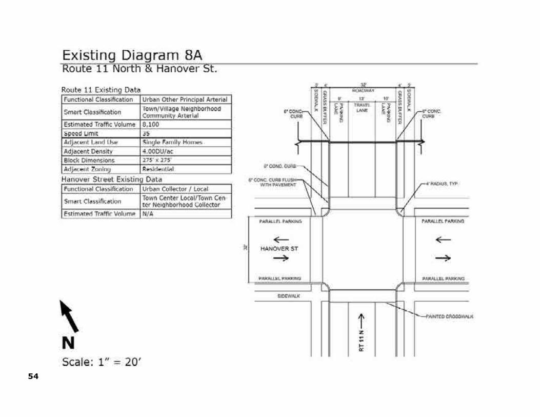
54

55
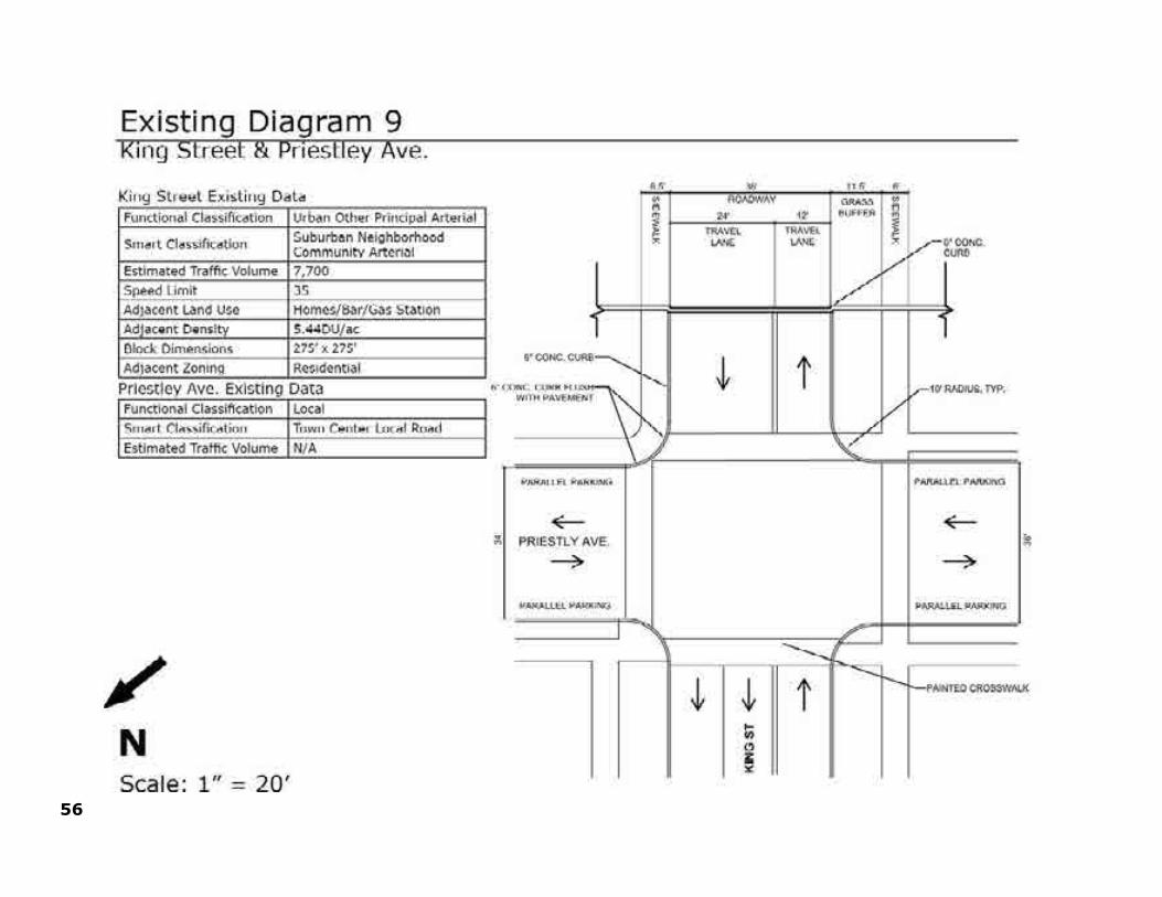
56
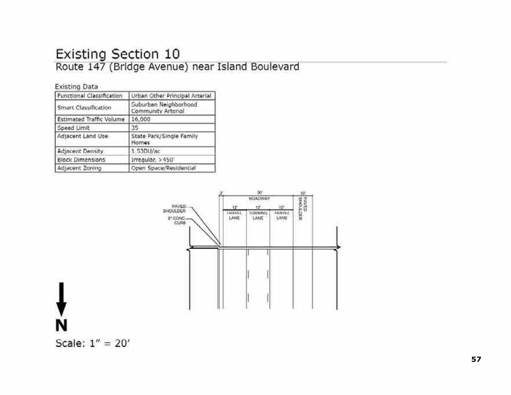
57

58

59
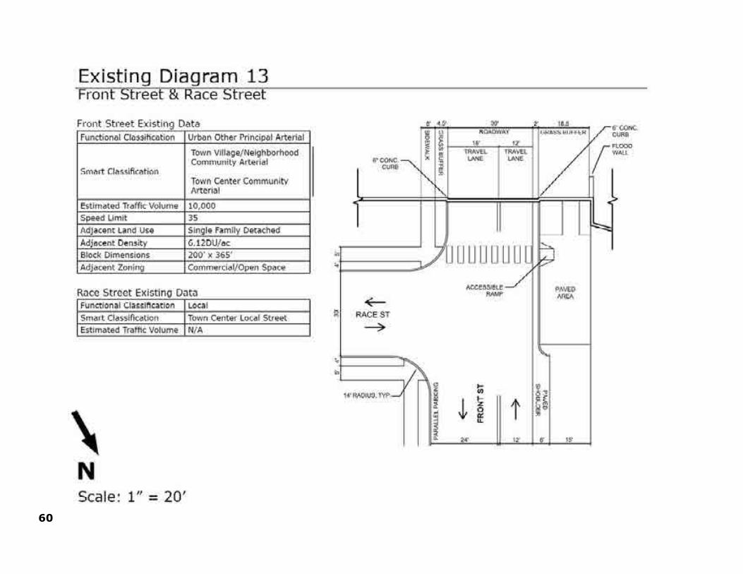
60

61

62 LAKE AUGUSTA GATEWAY CORRIDOR

63LAKE AUGUSTA GATEWAY CORRIDOR
Defining a Smart Transportation Classification Scheme for the Lake Augusta Gateway Corridor
Traditional transportation systems are designed using the functional classification system established by the Federal Highway Administration. Functional classification is the process by which streets and highways are grouped into classes, or systems, according to the character of traffic service that they are intended to provide. There are three highway functional classifications: arterial, collector, and local roads.
All streets and highways are grouped into one of these classes. Arterials couple a high level of mobility with a greater degree of access control. Local facilities provide a high level of access to adjacent properties but a low level of mobility. Collector roadways provide a balance between mobility and land access. As previously described, smart transportation builds on standard approaches to traffic planning. It provides designers with added flexibility needed to calibrate systems to the needs of each place and project.
Distinctions between standard functional classification, existing and proposed smart transportation classifications are illustrated in the ensuing maps and map diagrams. The proposed smart transportation scheme is the framework used to formulate project concepts embodied in The Lake Augusta Gateway Corridor Plan. It illustrates and demonstrates a required first step for proposing changes to the road right of way, such as sidewalks or wider shoulders.
Combined land use and functional classification information was used to establish the existing smart transportation classification for each calibrated roadway section. For example, the Route 11 segment between the Route 11-15 junction and the White Bridge into Northumberland was classified as a rural regional arterial. The roadway’s multiple lanes, wide shoulders, usage volume, and speed limit are characteristic of its regional arterial designation. The scenic and rural land-use along this stretch of road establishes its “rural” context.
This classification methodology was applied to strategic roadway sections throughout the Lake Augusta corridor and was compiled into an existing Smart Transportation classification map. The existing map was used to determine where transportation improvements or investments could be made. Conflicts between land use and transportation were easily identified on the existing smart transportation map and were studied in further detail.
Solutions are proposed for targeted roadway sections and intersections to achieve greater consistency in the relationship between land-use and transportation in the region. These solutions specifically addressed pedestrian and bike connectivity, safety, future planned land-use, recreation, and aesthetic character.
The proposed smart transportation classification map illustrates the system framework after the proposed strategic improvements have been implemented. The smart transportation categorization of some stretches of roadway did not need to change and remained the same, while other sections of roadway needed to be updated to reflect the proposed improvements. As shown on the proposed map, the result of these changes will be a transportation system that more closely matches regional land use and community character.

64 LAKE AUGUSTA GATEWAY CORRIDOR
Figure 11–Lake Augusta Transportation Context—Standard Functional Highway Classification Scheme

65LAKE AUGUSTA GATEWAY CORRIDOR
Figure 12–Lake Augusta Transportation Context—Existing Smart Transportation Classification Scheme

66 LAKE AUGUSTA GATEWAY CORRIDOR
Figure 13–Lake Augusta Transportation Context—Proposed Smart Transportation Classification Scheme

67LAKE AUGUSTA GATEWAY CORRIDOR
Building Community Success via Smart Transportation Planning, Design and Development
Lake Augusta is a target area for asset-based development and environmental enhancement, and for events and activities connecting Middle Susquehanna river towns via the Susquehanna Greenway. The smart transportation proposals proffered in this chapter of The Lake Augusta Gateway Corridor Plan will help shape a desired image and identity for the area and align public-private investment to achieve a future transportation system that is safe, functional and multi-purposed.
The proposals address system needs in the larger context of the gateway corridor—the roadway, community, economy, environment and finances. Achieving the intended benefits of the Plan requires state and municipal governments and other stakeholders to embrace its regional vision. Implementation of the action strategies requires local-regional teamwork, effective and sustained leadership, a multi-disciplinary perspective, and continued community involvement.
The Lake Augusta Gateway Plan is a regional transportation plan for a regional community. Consider the following points:
1. Public use and enjoyment of Lake Augusta has grown over the decades, but Lake Augusta remains an underdeveloped community, economic and environmental asset.
2. The urbanized area of Lake Augusta centered on Sunbury, Northumberland and Shamokin Dam is a destination for river-based recreation and a hub on the Susquehanna Greenway—a growing network of land and water trails connecting about 70 Susquehanna River towns in Pennsylvania.
3. Seven municipalities—Sunbury, Northumberland and Shamokin Dam, Upper Augusta, Point, Union and Monroe townships—constitute the Lake Augusta Gateway Community—these places are linked by the river with the potential to prosper even more through regional action keyed to Lake Augusta development.
4. To capitalize on these locational or place-based advantages—the Lake Augusta Gateway Plan sets forth a unified transportation development concept to serve riverfront development deemed essential to the regional economy. It includes development proposals for each municipality.
5. These proposed projects range from short to long term in execution—they conform to local development objectives as determined through this and other local plans precedent to the Lake Augusta Plan.
6. Achieving the Lake Augusta vision requires new thinking about the regional transportation system serving the Lake Augusta Gateway Community—smart thinking about Smart Transportation and Smart Growth for the region—smart thinking about access to the Lake Augusta experience—about mobility in and around the Lake Augusta Community—about transportation safety—and about a range of transportation modes—not just motor vehicles—but also bicycles and pedestrians.
7. Achieving the Lake Augusta vision also requires smart thinking about the role of transportation development in helping to enhance the Lake Augusta environment—the resident and visitor experience—and stimulating new businesses and jobs linked to tourism and related community and economic development.
LAKE AUGUSTA GATEWAY CORRIDORTHE SMART TRANSPORTATION PLAN

68 LAKE AUGUSTA GATEWAY CORRIDOR
RiverLink—A Master Plan Concept
RiverLink joins the idea of confluence and connection. It aims to build a green economy and transportation system in the Lake Augusta Community—to foster a flowing together of people and the River.
RiverLink is a development concept and strategy for the urbanized Lake Augusta gateway corridor—a plan for enhancing river use and enjoyment, for improving community health and for sustaining the river-river town environment. RiverLink is a transportation concept and strategy—a plan for achieving enhanced community access, safety and mobility through multi-modal transportation and context-sensitive transportation design.
Lake Augusta provides an asset of common reference and central importance to the region. Its shoreline streets, roadways, and trails comprise pathways connecting to the Susquehanna Greenway and its recreational attractions. Its river bridges mark community and regional gateways to the Middle Susquehanna experience—to river town
neighborhoods, culture and commerce.
RiverLink begins the drive, walk and float to greater regional prosperity—to grow the region’s green economy, provide jobs, and enhance the river town experience with renewed focus and purpose—to improve the ecology of the region, its attraction for urban living, and to enhance the area’s transportation network with added focus on walking, bicycling, and transit.
RiverLink is both a process and a plan—it charts a path to better living and more widely shared prosperity. Its aims are short- and long-term. RiverLink sets a starting point for regional community-building and collaboration. RiverLink action strategies aim for wide ranging results and benefits important to residents of the Lake Augusta Community, area visitors, businesses and institutions.
The RiverLink concept diagram illustrates the fundamental ingredients of a future vision for land use, community and economic development, transportation enhancement, environmental conservation, and recreation development in the Lake Augusta Community. Its purpose is to communicate a unifying concept for the Lake Augusta gateway corridor—to provide a schematic illustration of the development concept underlying the master plan concept.
Key components of the RiverLink concept include:
1. Susquehanna River Ecology—Enlarge understanding of the river-land connection relating to water quality, aquatic biology, fish and wildlife habitat and educate the community on the relationship between community health and the environment.
2. Lake Augusta Access and Recreation—Extend and enhance riverfront access to Lake Augusta for beneficial and sustainable recreational uses and activities.
3. River Town Gateways—Develop gateway parks and companion neighborhoods, landscapes and streetscapes to enhance river town image and coordinate regional identity.

69LAKE AUGUSTA GATEWAY CORRIDOR
Figure 14–Lake Augusta RiverLink Concept Diagram

70 LAKE AUGUSTA GATEWAY CORRIDOR
Smart Projects for the Lake Augusta Community
The Lake Augusta gateway corridor consists of varied land uses and transacts multiple jurisdictions. The transportation system improvements recommended in this chapter are tailored to the individual communities and their outlying areas. The project concepts described herein conform to the methodology established in PennDOT’s Smart Transportation Guidebook and provide a point of departure for future transportation design and development in the Lake Augusta region.
The Lake Augusta Gateway Corridor Plan proposes a mix of smart growth-smart transportation projects for the gateway area. In finalizing the proposed improvement scheme consideration was given to the following factors:
1. Regional Land Use—Some of the proposed transportation solutions help to enhance or preserve the existing community context. Other solutions were developed anticipating a different future land use.
2. Local Regional Transportation System—All of the solutions developed took into consideration the different methods by which people get around.
3. Local Regional Economic Development—The transportation improvements aim to improve more than just transportation. The proposed improvements will have a positive impact on the economy, environment and quality of life.
Following is a summary of community assets and proposed transportation system improvements addressed in the smart transportation plan. Project commentary is keyed to the master plan drawing.
4. River Town Intersections—Implement key intersection improvements to accommodate motor vehicle traffic and promote safe walking and bicycling for all ages.
5. Riverfront Parks and Attractions—Build a unified and connected regional riverfront park system as living filters to mitigate transportation induced water pollution, improve river health, and foster outdoor recreation, daily exercise and tourism beneficial to the health and vitality of river town neighborhoods.
6. Riverfront Parkways and Trailways—Build a safe, accessible, and functionally integrated multi-modal transportation system for local and regional travel, for resident and visitor use, with continuous connected riverfront trails and access areas for scenic viewing, boat launching and mooring, exercise walking and running, and bicycle touring.
7. River-River Town Neighborhood Connections—Through urban design, streets and alleys, green development, transit, and public education, create new ways for people to live, work, recreate, socialize, and connect along the Lake Augusta riverfront.
8. River Town Development Themes—Stimulate interest in and use of Lake Augusta and its connected towns and neighborhoods through thematic marketing, promotion of river town parks, attractions, events and business opportunities, through historic preservation, new urban design, and context-sensitive transportation design.
71LAKE AUGUSTA GATEWAY CORRIDOR
Susquehanna River Sports Park-Shamokin Dam Town Center
This concept (Map Legend No’s. 2, 3) expands on the SEDA-COG River Sports Park Feasibility Study completed in 2009. The adjacent land use and transportation system would be modified to accommodate the recreational facility. The transportation system would provide access to the site. River front investment of this type would also create an opportunity for denser urban development of the adjacent K-Mart and Orchard Hills Shopping Plazas.
Lake Augusta Scenic Parkway
It was determined that the best alignment for the Lake Augusta Parkway (Map Legend No’s. 1, 14, 15) is in its current location with the realignment of selected areas to allow for improving bicycle and pedestrian trails. The trailway would be between the roadway and the river, providing scenic and recreational interest. This strategy is most cost effective and also the most attractive option to hikers and bikers
Old Town Northumberland-Pineknotter Park
Improvements are suggested for several intersections and roadway sections in Northumberland (Map Legend No’s. 12, 13). The goal is to improve pedestrian access to the downtown, downtown safety and aesthetics, and to create safe pedestrian connections to riverfront parks.
Packer Island Gateway
Bridge Avenue streetscape improvements (Map Legend No’s. 9, 10, 11) are proposed to create an island-wide gateway into Sunbury and Northumberland. Streetscape improvements, including street adjustments, landscaping, lighting, and designated pedestrian crossings will enhance neighborhood aesthetics, reduce traffic speed, funnel pedestrians to 2 designated crosswalks, and improve pedestrian connections to the river and to Shikellamy State Park.
Sunbury Enhancements
Sunbury enhancements (Map Legend No’s. 5, 7, 8) include strategically located pedestrian and bicycle routes and completion of the riverfront Front Street enhancements. Areas have been identified for more safe and functional pedestrian crossings to the riverfront. Additional traffic studies may be warranted to further evaluate new neighborhood development proposals included in Sunbury’s 2012 comprehensive plan.
Shamokin Creek Park and Greenway
The Shamokin Creek Parkway (Map Legend No. 6) is a long term concept that could alleviate future congestion on Front and Market streets and provide an alternate street route to circumnavigate the city. The corridor would parallel the Shamokin Creek levee and connect with Route 61 at the City’s east and west gateways. It would serve as a parkway and a greenway for bikers, pedestrians and wildlife and would create additional street connections into Sunbury from its southern edge.
South Gate—Sunbury’s Rt. 61 Gateway
Sunbury’s 2012 comprehensive plan proposes new commercial development at the Route 61 interchange between Front and Second streets (Map Legend No. 4). Long range plans for this gateway area include the development of a restaurant and small hotel. This type of development would change traffic patterns and further studies will need to be done.

72 LAKE AUGUSTA GATEWAY CORRIDOR
Marketing and Branding of Lake Augusta
Lake Augusta is a regional community of people and a geographic place. Implementing projects like those described above would benefit from a more cohesive regional image. Signage, banners, media and logos help establish an identity for further marketing the Lake Augusta gateway area.
These projects are further illustrated in the following pages. The intended impact of the proposed transportation projects is to:
1. Increase safety, access and mobility for motorists, bicyclists and pedestrians.
2. Enhance existing community and environmental assets,
3. Create a new resident and visitor experience.
4. Create new potential for economic development linked to public use and enjoyment of community and environmental assets.
No attempt has been made to formally prioritize these multi-municipal projects. However, it is understood that priorities are necessary and properly established in the local-county transportation project priorities set through the SEDA-COG RPO transportation planning process.
Short term projects would include those recommended for inclusion on the region’s Transportation Improvement Program (TIP). This establishes priorities in a 1-3 year timeframe and would include basic bike-pedestrian-motor vehicle safety projects.
Medium range projects would include those listed to PennDOT’s 12 Year Transportation Program for the region. This could include projects such as streetscape or canal park enhancements, transportation-linked trails, interpretive and access signage, project r.o.w. acquisition (roadway, vistas, trails, and rest areas, etc.).
Long range projects are those included in PennDOT’s Long Range Transportation Plan (LRTP) for the region. These projects fall within a 12-20 year timeframe for action. The Lake Augusta Scenic Parkway, Route 11-15 intersection changes and Shamokin Creek Parkway are viewed as long range priorities.

73LAKE AUGUSTA GATEWAY CORRIDOR
The Lake Augusta Gateway Corridor Master Plan
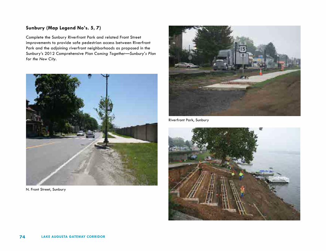
74 LAKE AUGUSTA GATEWAY CORRIDOR
Sunbury (Map Legend No’s. 5, 7)
Complete the Sunbury Riverfront Park and related Front Street improvements to provide safe pedestrian access between Riverfront Park and the adjoining riverfront neighborhoods as proposed in the Sunbury’s 2012 Comprehensive Plan Coming Together—Sunbury’s Plan for the New City.
N. Front Street, Sunbury
Riverfront Park, Sunbury

75LAKE AUGUSTA GATEWAY CORRIDOR
Sunbury (Map Legend No. 8)
Pursue a mix of street greening, streetscape improvements, and bicycle-pedestrian improvements as proposed in the Sunbury’s 2012 Comprehensive Plan Coming Together—Sunbury’s Plan for the New City.
Enhanced Streetscape-Intersection Design
Enhanced Bicycle-Pedestrian Design

76 LAKE AUGUSTA GATEWAY CORRIDOR
The Lake Augusta Gateway Corridor Master Plan

77LAKE AUGUSTA GATEWAY CORRIDOR
Upper Augusta Township (Map Legend No. 9)
Enhance the Shikellamy Avenue streetscape in Upper Augusta Township to improve motor vehicle, bicycle and pedestrian access to Sunbury’s N. Fourth Street commercial district.
Upper Augusta Township (Map Legend No. 10, 11)
Develop the Bridge Avenue gateway streetscape in Upper Augusta Township to provide safe bike and pedestrian connections between Sunbury and Northumberland—to connect Borough and City residents with Shikellamy State Park.—and to connect park and island visitors to services and attractions in Northumberland and Sunbury.
Bridge Avenue, Packer Island
N. Fourth Street Sunbury
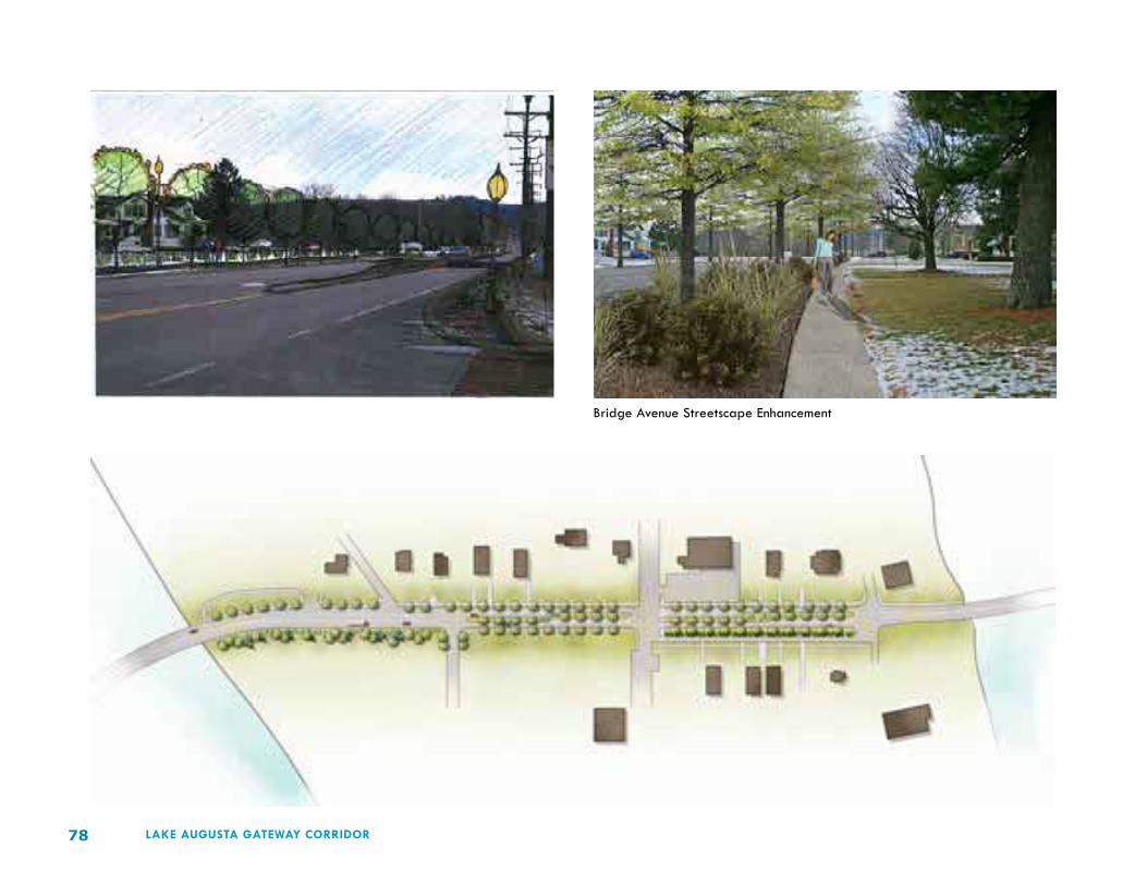
78 LAKE AUGUSTA GATEWAY CORRIDOR
Bridge Avenue Streetscape Enhancement

79LAKE AUGUSTA GATEWAY CORRIDOR
The Lake Augusta Gateway Corridor Master Plan

80 LAKE AUGUSTA GATEWAY CORRIDOR
Point Township—Northumberland (Map Legend No. 12)
Complete riverfront access and trail development in Point Township and Northumberland to close gaps in riverfront connectivity
Northumberland—Point Township (Map Legend No. 13)
Complete streetscape design and intersection safety improvements in Northumberland and Point Township to enhance the northern gateway experience, facilitate bicycle and pedestrian connections to downtown Northumberland and to Northumberland parks and historic sites.
Northumberland Riverfront Trail
Front Street, Northumberland
Water Street, Northumberland

81LAKE AUGUSTA GATEWAY CORRIDOR
The Lake Augusta Gateway Corridor Master Plan

82 LAKE AUGUSTA GATEWAY CORRIDOR
Union and Monroe Townships (Map Legend No’s. 1, 14, 15)
Protect the scenic Blue Hill bluff in Monroe and Union Townships as the iconic “Mount Nittany”-type landscape feature which is fundamentally important to the Lake Augusta “sense of place” and recreation experience.
View of Blue Hill from Northumberland View of River Confluence from Union Township

83LAKE AUGUSTA GATEWAY CORRIDOR
Union and Monroe Townships (Map Legend No’s. 1, 14, 15)
Develop the Lake Augusta Scenic Parkway and Trailway between Northumberland and Shamokin Dam to provide an enhanced scenic drive and unobstructed bike and pedestrian access to the west shore riverfront in Union and Monroe Townships and Shamokin Dam.
River Shore, Susquehanna Trail (US 11)

84 LAKE AUGUSTA GATEWAY CORRIDOR
The Lake Augusta Gateway Corridor Master Plan

85LAKE AUGUSTA GATEWAY CORRIDOR
Shamokin Dam (Map Legend No. 2)
Develop the proposed Susquehanna River Sports Park in the gateway area to establish a local-regional and statewide venue for rowing with a related visitor center, restaurant and lodging at the US 11-15 junction.
Proposed Rowing Venue at US 11-15 Junction

86 LAKE AUGUSTA GATEWAY CORRIDOR
Shamokin Dam (Map Legend No. 2)
Redevelop the Orchard Hills Plaza and K-Mart Plaza sites in Shamokin Dam for mixed riverfront commercial and condominium development in a town-like center.
Mixed-Use New Urban Development Concepts
Orchard Hills Plaza, Shamokin Dam
Junction US 11-15

87LAKE AUGUSTA GATEWAY CORRIDOR
The Lake Augusta Gateway Corridor Master Plan

88 LAKE AUGUSTA GATEWAY CORRIDOR
Shamokin Dam (Map Legend No. 3)
Develop enhanced highway access from US 11-15 at 8th Street in Shamokin Dam to establish a more visible and direct link to Fabridam Park.
Shamokin Dam (Map Legend No. 3)
Develop proposed fish passages in Shamokin Dam and Sunbury to support migratory fish populations and related sport fishing above the Fabridam.
Fabridam Park, Shamokin Dam

89LAKE AUGUSTA GATEWAY CORRIDOR
The Lake Augusta Gateway Corridor Master Plan

90 LAKE AUGUSTA GATEWAY CORRIDOR
Southgate Interchange Development Concept (PA 61) Sunbury
Sunbury (Map Legend No. 4)
Develop the Rt. 61 Southgate Interchange in Sunbury to capitalize on the City’s inherent locational advantages for transportation and economic development as proposed in the Sunbury’s 2012 Comprehensive Plan Coming Together—Sunbury’s Plan for the New City.

91LAKE AUGUSTA GATEWAY CORRIDOR
Shamokin Creek Parkway Concept
Sunbury (Map Legend No. 6)
Develop the Shamokin Creek Parkway and Greenway in Sunbury to relieve in-City traffic congestion and provide improved access to City destinations as proposed in the Sunbury’s 2012 Comprehensive Plan Coming Together—Sunbury’s Plan for the New City.

92 LAKE AUGUSTA GATEWAY CORRIDOR

93LAKE AUGUSTA GATEWAY CORRIDOR
Moving Ahead with Smart Growth-Smart Transportation
The role of transportation planning in achieving desired aims for the Lake Augusta Gateway community cannot be understated. While the Lake is ringed by local streets and interregional roadways, access to the River remains difficult at best. The area lacks a network of safe and well-connected infrastructure to serve pedestrians and bicyclists.
As a hub of local streets and regional roadways, the area faces the prospect of worsening traffic congestion, increased competition for available space and more conflicts between motorists, bicyclists and pedestrians. The Lake Augusta Gateway Corridor Plan provides a remedy for design and action in the form of integrated policy guidance for transportation, environmental conservation, community and economic development. It promotes public-private collaboration to continually improve the region’s urban waterfront as an investment strategy for regional development.
The Plan proposals are context-sensitive transportation solutions. They accommodate relevant modes of transportation and address network connectivity, safety, access, and corridor management—all fundamentally important to community and economic development and environmental enhancement within the gateway corridor.
Over time, implementation of the identified projects will leverage and preserve the value of existing transportation and community investments. In this application, transportation system planning has the potential to strengthen local partnerships for land use planning and local-state partnerships to improve the sustainability and livability of the region’s river towns.
The outcomes of this plan will benefit regional residents and visitors alike. Implementation of Lake Augusta Gateway strategies will create new close-to-home recreational opportunities for residents and
enhanced conditions for neighborhood revitalization and development in adjoining river towns. Equally as important, these strategies will help create a travel destination for visitors with related business and employment opportunities for the region and for related community development.
The strategies charted in this chapter focus generally on interconnected themes relating to: 1) Community Safety and Environmental Health, 2) Enhancing Local-Regional Access and Mobility, 3) Building the Green Economy, and 4) Organizing for Action. Each group of strategies plotted presents a brief description of the relevant issue, related goals and objectives, and suggested timeframes for action. Implementation roles and responsibilities are defined for public-private action. Potential action partners are listed with suggestions for lead agencies, organizations or institutions.
LAKE AUGUSTA GATEWAY CORRIDORTHE ACTION STRATEGIES

94 LAKE AUGUSTA GATEWAY CORRIDOR
SUSQUEHANNA RIVER AND LAKE AUGUSTA RESEARCH AND MONITORING PROGRAM
ISSUE: Maintaining water quality in the Susquehanna River is fundamental to the realization of regional development goals for the Lake Augusta gateway corridor.
GOAL: The water quality of the Susquehanna River is good and improving – offering excellent sport fishing opportunities and a safe venue for swimming, rowing and other water recreation activities.
LEAD: Susquehanna River Heartland Coalition for Environmental Studies.
PARTNERS: DCNR, DEP, Bucknell University, Susquehanna University, Lycoming College, Lock Haven University, Bloomsburg University, Kings College and the Susquehanna Greenway Partnership.
Architect’s Rendering of Environmental Research Center

95LAKE AUGUSTA GATEWAY CORRIDOR
OBJECTIVES ACTIONS TIMEFRAMES ROLES
YR 1-2 YR 3-5 YR 5-10 PUBLIC PRIVATEPUBLIC-PRIVATE
Develop Research and Education Facility on Lake Augusta
Redevelop the marina building at Shikellamy State Park – as a research and education center
XXX XX
Establish and Maintain Research and Education Programs at the new facility XXX XXX XXX XX
Water Quality Monitoring for the Susquehanna River Watershed
(River)
Define and Implement a water-quality monitoring program, using both biotic and abiotic factors, to characterize river health and water-quality change over time
XXX XXX XXX XX
Create strategic partnerships to fund and implement water-quality monitoring program XXX XX
Collect and Interpret water-quality data and make available to interested agencies and the general public
XXX XXX XX
Lake Augusta Research
(Lake)
Define and Implement a research program for Lake Augusta – evaluating the impact of the dam and water-quality data for the impoundment and influence from the two branches of the river
XXX XXX XXX XX
Create strategic partnerships to fund and implement water-quality monitoring program XXX XX
Collect, interpret and publicize Lake Augusta water-quality data and incorporate knowledge into management plan
XXX XXX XX
Management Plan Summarize Susquehanna River and Lake Augusta research results and translate findings into a Management Plan for Lake Augusta
XXX XX
POTENTIAL FUNDING SOURCES: National Science Foundation, POWR (PA Organization for Watersheds and Rivers), Chesapeake Bay Commission, PA Fish and Boat Commission, DCNR, DCED, DEP, Private and University In-Kind.

96 LAKE AUGUSTA GATEWAY CORRIDOR
SUSQUEHANNA GREENWAY LAND CONSERVATION CORRIDOR
ISSUE: The scenic forested ridge that frames the western edge of Lake Augusta is primarily in private ownership and lacks protections from development.
GOAL: Preservation of the scenic qualities and ecological function of the forested ridge parallel to Route 11 (Monroe Township and Union Township).
LEAD: Lake Augusta Organization (See Lake Augusta Organizational Arrangements).
PARTNERS: PA DCNR, Linn Conservancy and Northcentral PA Conservancy, PennDOT, Susquehanna Greenway Partnership, Susquehanna River Heartland Coalition for Environmental Studies and Bucknell University.
Blue Hill Scenic Landscape
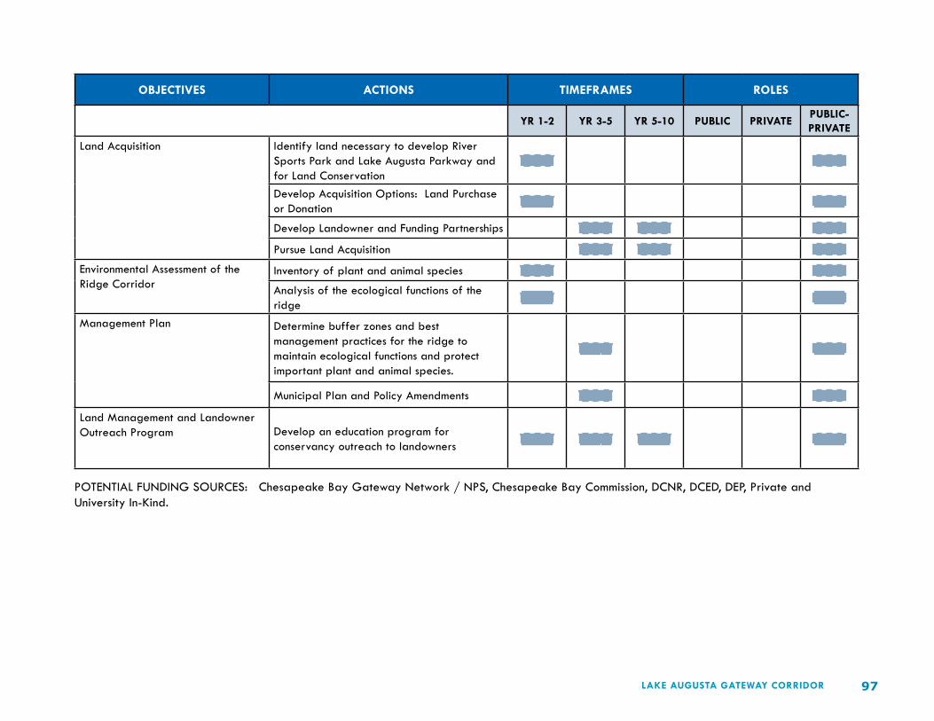
97LAKE AUGUSTA GATEWAY CORRIDOR
OBJECTIVES ACTIONS TIMEFRAMES ROLES
YR 1-2 YR 3-5 YR 5-10 PUBLIC PRIVATEPUBLIC-PRIVATE
Land Acquisition Identify land necessary to develop River Sports Park and Lake Augusta Parkway and for Land Conservation
XXX XXX
Develop Acquisition Options: Land Purchase or Donation XXX XXX
Develop Landowner and Funding Partnerships XXX XXX XXXPursue Land Acquisition XXX XXX XXX
Environmental Assessment of the Ridge Corridor
Inventory of plant and animal species XXX XXXAnalysis of the ecological functions of the ridge XXX XXX
Management Plan Determine buffer zones and best management practices for the ridge to maintain ecological functions and protect important plant and animal species.
XXX XXX
Municipal Plan and Policy Amendments XXX XXXLand Management and Landowner Outreach Program Develop an education program for
conservancy outreach to landowners XXX XXX XXX XXX
POTENTIAL FUNDING SOURCES: Chesapeake Bay Gateway Network / NPS, Chesapeake Bay Commission, DCNR, DCED, DEP, Private and University In-Kind.

98 LAKE AUGUSTA GATEWAY CORRIDOR
SUSQUEHANNA RIVER SPORTS PARK & SHAMOKIN DAM TOWN CENTER
ISSUE: Lands located at the junction of US Routes 11-15 have significant potential for mixed recreation, commercial and residential (re)development.
GOAL: Develop a mixed-use riverfront that includes facilities for river rowing, a boathouse, visitor center, hotel, restaurant and canal park and trail with linkages to adjacent office and residential development.
LEAD: Central PA Rowing Association and Shamokin Dam Borough.
PARTNERS: PennDOT, DCNR, Shamokin Dam Borough, Monroe Township, Northumberland Boat Club, Greater Susquehanna Valley Chamber of Commerce, Susquehanna River Valley Visitors Bureau, Susquehanna Greenway Partnership, SEDA-COG RPO, SEDA-COG CRC, Bucknell University and Susquehanna University.
Shamokin Dam Town Center Development Concept

99LAKE AUGUSTA GATEWAY CORRIDOR
OBJECTIVES ACTIONS TIMEFRAMES ROLES
YR 1-2 YR 3-5 YR 5-10 PUBLIC PRIVATEPUBLIC-PRIVATE
Land Acquisition (See Susquehanna Greenway Land Conservation Corridor)
Identify land necessary to develop River Sports Park and Lake Augusta Parkway and for Land Conservation
XXX XXX
Develop Acquisition Options: Land Purchase or Donation XXX XXX
Develop Landowner and Funding Partnerships XXX XXX XXXPursue Land Acquisition XXX XXX XXX
Preliminary Engineering - U.S. 11/15 Corridor Study
Roadway and Access Study and Environmental Assessment XXX XXX
Engineering Design XXX XXXConstruction XXX XXX
Preliminary Engineering - U.S. 11/15 Corridor Study
Master Site Plan XXX XXXFinal Engineering and Design XXX XXXConstruction XXX XXX
Riverfront Park Master Site Plan XXX XXXFinal Engineering and Design XXX XXXConstruction XXX XXX
Shamokin Dam Town Center Market Analysis XXX XXXMaster Site Planning XXX XXXFinal Design XXX XXXConstruction XXX XXX
Susquehanna River Sports Park Survey and Master Plan XXX XXXEnvironmental Review and Permitting XXX XXXFinal Engineering and Design XXX XXXConstruction XXX XXX
POTENTIAL FUNDING SOURCES: ARC, Transportation Enhancements, ARLE, PCTI, RTP, STP, TE, TIGER, DCNR, DCED, Private Investors, Bucknell University and Susquehanna University.

100 LAKE AUGUSTA GATEWAY CORRIDOR
LAKE AUGUSTA SCENIC PARKWAY
ISSUE: Address roadway safety, function, design and aesthetics.
GOAL: Create a memorable regional gateway by creating a scenic 2-lane parkway on the west shore of Lake Augusta (PA Route 11) that includes landscaping, overlook picnicking and a riverfront greenway with a pedestrian-bicycle trail.
LEAD: Lake Augusta Organization and SEDA-COG.
PARTNERS: PennDOT, DCNR, SEDA-COG RPO, Lake Augusta Regional Organization.
Parkway Scenic Viewing Area Concept

101LAKE AUGUSTA GATEWAY CORRIDOR
OBJECTIVES ACTIONS TIMEFRAMES ROLES
YR 1-2 YR 3-5 YR 5-10 PUBLIC PRIVATEPUBLIC-PRIVATE
Land Acquisition (See Susquehanna Greenway Land Conservation Corridor)
Identify land necessary to develop River Sports Park and Lake Augusta Parkway and for Land Conservation
XXX XXX
Develop Acquisition Options: Land Purchase or Donation XXX XXX
Develop Landowner and Funding Partnerships XXX XXX XXXPursue Land Acquisition XXX XXX XXX
Preliminary Engineering - Parkway / Greenway Master Site Planning
Evaluate alternative roadway re-design options XXX XXX
Evaluate pedestrian and bicycle trail alignment and design options XXX XXX
Municipal Plan and Policy Amendments XXX XXXFinal Engineering and Design Survey, Design and Permit the Parkway and
Greenway Design XXX XXX
Project ConstructionInitiate Construction XXX XXX
POTENTIAL FUNDING SOURCES: Transportation Enhancements, PCTI, RTP, STP, TIGER, DCNR, DCED, Private and Municipal.

102 LAKE AUGUSTA GATEWAY CORRIDOR
NORTHUMBERLAND - PINEKNOTTER RIVERFRONT PARK
ISSUE: Northumberland’s riverfront is underused, but offers great potential for active and passive recreation.
GOAL: Conserve and restore natural areas and establish a riverfront trail connecting Pineknotter Park to adjoining river access areas and neighborhoods.
LEAD: Borough of Northumberland and www.17857.org.
PARTNERS: Point Township, DCNR, SEDA-COG CRC, Susquehanna Greenway Partnership, Friends of Shikellamy State Park and PennDOT.
Northumberland River Shore

103LAKE AUGUSTA GATEWAY CORRIDOR
OBJECTIVES ACTIONS TIMEFRAMES ROLES
YR 1-2 YR 3-5 YR 5-10 PUBLIC PRIVATEPUBLIC-PRIVATE
Park Planning Park Master Site Plan XXX XXXMunicipal Plan and Policy Amendments XXX XXX
Park Construction Implementation of Phase I Park Improvements XXX XXXImplementation of Phase II Park Improvements XXX XXX
POTENTIAL FUNDING SOURCES: DCNR, RTP, DCED, Municipal and Volunteers.

104 LAKE AUGUSTA GATEWAY CORRIDOR
DUKE STREET CORRIDOR
ISSUE: Duke Street (PA Route 147) is an unsafe and unsightly roadway corridor.
GOAL: Enhance Duke Street between PA Route 11 and 8th Street, to control access and improve safety and aesthetics of the corridor.
LEAD: Borough of Northumberland and www.17857.org.
PARTNERS: PennDOT, DCED, Commercial and Residential Property Owners, SEDA-COG RPO, SEDA-COG CRC, Bucknell University Engineering Department and Penn State University Department of Landscape Architecture.
Duke Street (PA 147) Northumberland

105LAKE AUGUSTA GATEWAY CORRIDOR
OBJECTIVES ACTIONS TIMEFRAMES ROLES
YR 1-2 YR 3-5 YR 5-10 PUBLIC PRIVATEPUBLIC-PRIVATE
Preliminary Engineering Duke Street Access Control Plan XXX XXXInitiate Partnerships with Bucknell and Penn State Universities – for engineering and design community service projects
XXX XXX XXX
Policy Implementation / PennDOT Evaluation of Access Control Options
Access Control Ordinance XXX XXX
PennDOT Evaluation XXX XXX
Municipal Plan and Policy Amendments XXX XXX
Final Engineering and DesignStreetscape Engineering and Design XXX XXX
Project Implementation Streetscape Enhancements – access control, landscaping, lighting. XXX XXX
POTENTIAL FUNDING SOURCES: Highway Safety Improvement Funds, Transportation Enhancements, ARLE, PCTI, RTP, SRTS, STP, TIGER, DCED, Municipal, University In-Kind.

106 LAKE AUGUSTA GATEWAY CORRIDOR
NORTHUMBERLAND BOROUGH INTERSECTION IMPROVEMENTS
ISSUE: Motor vehicle traffic on PA Route 11 creates unsafe conditions for pedestrian and bicycle movement for area residents and visitors.
GOAL: Enhance Route 11 (Water Street and Front Street) intersections to reduce traffic speed and improve the safety of pedestrian and bicycle crossings.
LEAD: Borough of Northumberland and www.17857.org.
PARTNERS: PennDOT, DCED, DCNR, Susquehanna Greenway Partnership, SEDA-COG RPO, SEDA-COG CRC.
Intersection of Front and King Streets

107LAKE AUGUSTA GATEWAY CORRIDOR
OBJECTIVES ACTIONS TIMEFRAMES ROLES
YR 1-2 YR 3-5 YR 5-10 PUBLIC PRIVATEPUBLIC-PRIVATE
Preliminary Engineering Streetscape Master Site Plan XXX XXXPennDOT Review XXXMunicipal Plan and Policy Amendments XXX XXX
Final Engineering and Design Final Design and Permitting XXX XXXInstall Bike Racks at Key Town Destinations XXX XXX
Project Implementation Construction of Streetscape Enhancements –Crosswalks, landscaping, signage and lighting XXX XXX
POTENTIAL FUNDING SOURCES: Highway Safety Improvement Funds, Transportation Enhancements, ARLE, PCTI, RTP, SRTS, STP, TIGER, DCED, Municipal.

108 LAKE AUGUSTA GATEWAY CORRIDOR
PACKER ISLAND GATEWAY
ISSUE: Wide roadways and high traffic volumes create unsafe driving conditions and impede pedestrian and bicycle access to Shikellamy State Park.
GOAL: Create a boulevard parkway for Bridge Avenue (PA Route 147) that will slow traffic and improve safety, while accommodating a bicycle and pedestrian trail and other streetscape enhancements
LEAD: Upper Augusta Township and Lake Augusta Organization.
PARTNERS: Friends of Shikellamy State Park, DCNR, SEDA-COG RPO, SEDA-COG CRC, Packer Island Residents and Commercial Interests.
Bridge Avenue Boulevard Concept

109LAKE AUGUSTA GATEWAY CORRIDOR
OBJECTIVES ACTIONS TIMEFRAMES ROLES
YR 1-2 YR 3-5 YR 5-10 PUBLIC PRIVATEPUBLIC-PRIVATE
Preliminary Engineering – Gateway Streetscape Planning
Traffic Study XXX XXXMunicipal and Land Owner Coordination XXXStreetscape Master Site Plan XXX XXXPennDOT Review XXX XXX
Municipal Plan and Policy Amendments XXX XXX
Final Engineering and DesignFinal Design and Permitting XXX XXX
Project Implementation Streetscape Enhancements – Pedestrian and Bicycle Trail, Boulevard Street Design, Street Trees and Lighting
XXX XXX XXX
POTENTIAL FUNDING SOURCES: Transportation Enhancements, PCTI, RTP, STP, TIGER, DCNR, DCED, Municipal and Corporate Donors.

110 LAKE AUGUSTA GATEWAY CORRIDOR
NORTH FRONT STREET AND RIVERFRONT PARK EXTENSION
ISSUE: Complete Sunbury Riverfront development and Front Street enhancements by extending park and streetscape improvements north to Bridge Avenue.
GOAL: Create a consistent riverfront streetscape and park along Front Street. Continue the park and streetscape north with street trees, river overlooks and improved pedestrian and bicycle access to Sunbury’s Caketown and Fort Augusta neighborhoods and to Shikellamy State Park.
LEAD: City of Sunbury and SRI.
PARTNERS: Sunbury Municipal Authority, US ACOE, DCED, DCNR, PennDOT, Susquehanna Greenway Partnership, Friends of Shikellamy State Park, SEDA-COG RPO, SEDA-COG CRC.
Riverfront Park, Sunbury
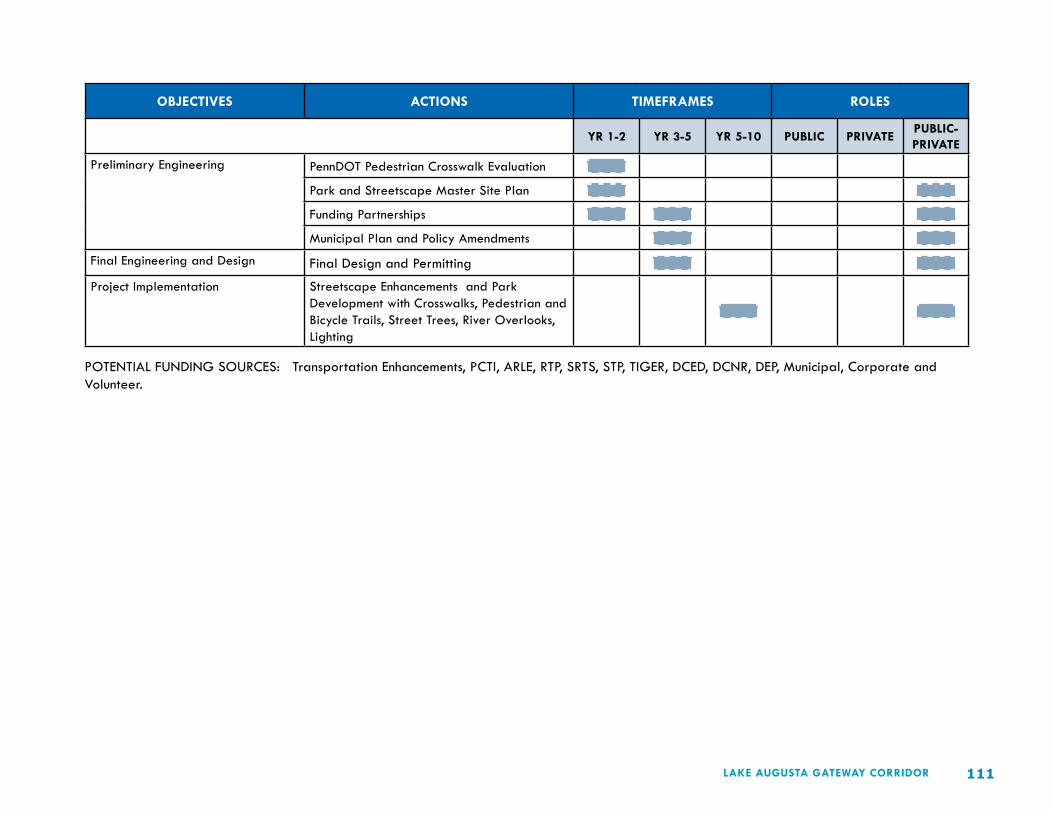
111LAKE AUGUSTA GATEWAY CORRIDOR
OBJECTIVES ACTIONS TIMEFRAMES ROLES
YR 1-2 YR 3-5 YR 5-10 PUBLIC PRIVATEPUBLIC-PRIVATE
Preliminary Engineering PennDOT Pedestrian Crosswalk Evaluation XXXPark and Streetscape Master Site Plan XXX XXXFunding Partnerships XXX XXX XXXMunicipal Plan and Policy Amendments XXX XXX
Final Engineering and Design Final Design and Permitting XXX XXXProject Implementation Streetscape Enhancements and Park
Development with Crosswalks, Pedestrian and Bicycle Trails, Street Trees, River Overlooks, Lighting
XXX XXX
POTENTIAL FUNDING SOURCES: Transportation Enhancements, PCTI, ARLE, RTP, SRTS, STP, TIGER, DCED, DCNR, DEP, Municipal, Corporate and Volunteer.

112 LAKE AUGUSTA GATEWAY CORRIDOR
NORTHUMBERLAND - SUNBURY BICYCLE NETWORK
ISSUE: The City is not bicycle friendly and needs to create better connections to destinations like the Shikellamy School Campus at the south end of town and the City’s Recreational Complex at the north end of town.
GOAL: Create a network of bicycle routes to safely link all parts of the Northumberland – Sunbury area.
LEAD: Borough of Northumberland, www.17857.org, City of Sunbury, SRI.
PARTNERS: PennDOT, Sunbury Streets Department, DCED, DCNR, SEDA-COG RPO, PennDOT, Susquehanna Greenway Partnership, Friends of Shikellamy State Park, SEDA-COG RPO, SEDA-COG CRC.

113LAKE AUGUSTA GATEWAY CORRIDOR
OBJECTIVES ACTIONS TIMEFRAMES ROLES
YR 1-2 YR 3-5 YR 5-10 PUBLIC PRIVATEPUBLIC-PRIVATE
Planning Develop Bicycle Concept Master Plan XXX XXXPennDOT Evaluation of Priority Routes XXX XXXSunbury – North – South Bike Lane XXX XXXFunding Applications XXX XXX XXXMunicipal Plan and Policy Amendments XXX XXX
Bike Lanes and Share the Road Routes
Municipal Plan and Policy Amendments XXX XXXSunbury North – South Bike Lane XXX XXXAlley Demonstration – Final Design XXX XXXShare the Road Routes – delineate with signage XXX XXX
Produce a Northumberland – Sunbury Bike Map and Guide XXX XXX
Install Bike Racks at Key Destinations XXX XXXConstruction - Alley Demonstration Project
Construction of Alley Demonstration Project – with enhanced parking, service access and shared spaces
XXX XXX
POTENTIAL FUNDING SOURCES: ARC, Transportation Enhancements, PCTI, ARLE, RTP, SRTS, STP, TIGER, Liquid Fuels Money, DCED, DCNR.

114 LAKE AUGUSTA GATEWAY CORRIDOR
NORTH FOURTH STREET ENHANCEMENTS
ISSUE: Access to the City of Sunbury’s North 4th Street commercial area is inefficient from the major regional arterial highways.
GOAL: Create improved access to the commercial area and re-design the area to fit its urban context and improve pedestrian and bicycle connections to the adjacent neighborhoods.
LEAD: City of Sunbury and SRI.
PARTNERS: PennDOT, Sunbury Streets Department, DCED, DCNR, SEDA-COG RPO, PennDOT, Susquehanna Greenway Partnership, Friends of Shikellamy State Park, SEDA-COG CRC.
Northway Plaza Concept

115LAKE AUGUSTA GATEWAY CORRIDOR
OBJECTIVES ACTIONS TIMEFRAMES ROLES
YR 1-2 YR 3-5 YR 5-10 PUBLIC PRIVATEPUBLIC-PRIVATE
Preliminary Engineering - Access and Site Redevelopment Planning
North 4th Street Access Study XXX XXXNorth 4th Street Commercial Area Redevelopment Concept Plan XXX XXX
Final Engineering and Design Roadway Access Engineering Design and Permitting XXX XXX
Commercial Area Site Engineering Plan and Approvals XXX XXX
Construction Roadway Access Implementation XXX XXXRedevelopment Construction XXX XXX
POTENTIAL FUNDING SOURCES: ARC, Transportation Enhancements, PCTI, ARLE, RTP, SRTS, STP, TIGER, Liquid Fuels Money, DCED, DCNR.

116 LAKE AUGUSTA GATEWAY CORRIDOR
SOUTH GATE – SUNBURY’S ROUTE 61 GATEWAY
ISSUE: The Neighborhoods at the south end of the city create a non-distinct entry to the City of Sunbury.
GOAL: Building upon strong City gateway assets such as Keithan’s Gardens, redevelop high-visibility residential and underused industrial sites. Create a memorable City gateway at the east end of Veterans Memorial Bridge (PA Routes 147-61) to stimulate neighborhood reinvestment.
LEAD: City of Sunbury and SRI.
PARTNERS: Private Developers, PennDOT, Sunbury Municipal Authority, Greater Susquehanna Valley Chamber of Commerce, Sunbury Redevelopment Authority, DCED, DCNR, SEDA-COG RPO, SEDA-COG CRC.
South Gate Development Concept

117LAKE AUGUSTA GATEWAY CORRIDOR
OBJECTIVES ACTIONS TIMEFRAMES ROLES
YR 1-2 YR 3-5 YR 5-10 PUBLIC PRIVATEPUBLIC-PRIVATE
Preliminary Engineering Access and Traffic Impact Study XXX XXX XXXDevelop Public Private Partnerships XXX XXX XXXConcept Master Site Plan XXX XXXEconomic Analysis XXX XXX
Final Engineering and Design Development Master Site Plan XXX XXXPennDOT and Municipal Review XXX XXXMunicipal Plan and Policy Amendments XXX XXX XXXDevelop and Implement Funding Strategy XXX XXXFinal Design and Permitting XXX XXX
Project Implementation Phased Implementation of the South Gate project XXX XXX
POTENTIAL FUNDING SOURCES: Transportation Enhancements, PCTI, RTP, SRTS, STP, TIGER, DCED, DCNR, Municipal.

118 LAKE AUGUSTA GATEWAY CORRIDOR
SHAMOKIN CREEK PARKWAY AND GREENWAY
ISSUE: Congestion from motor vehicle through-traffic, particularly truck traffic, negatively impacts Sunbury’s downtown and neighborhoods.
GOAL: Create an urban street parkway that will serve as a bypass for Route 61 traffic while providing improved access to downtown Sunbury and adjacent neighborhood destinations. Create related pedestrian and bicycle trails along Shamokin Creek.
LEAD: City of Sunbury and Lake Augusta Organization.
PARTNERS: PennDOT, SRI, Sunbury Municipal Authority, Shikellamy School District, DCNR, Susquehanna Greenway Partnership, SEDA-COG RPO, SEDA-COG CRC.
Shamokin Creek Parkway-Greenway Concept

119LAKE AUGUSTA GATEWAY CORRIDOR
OBJECTIVES ACTIONS TIMEFRAMES ROLES
YR 1-2 YR 3-5 YR 5-10 PUBLIC PRIVATEPUBLIC-PRIVATE
Study – Feasibility Assessment Traffic Study XXX XXXLand Owner Coordination XXX XXXCost / Benefit Analysis XXX XXXEIS XXX XXX
Planning and Design Parkway and Greenway Master Site Plan XXXPennDOT Review XXXMunicipal Plan and Policy Amendments XXX XXX
Final Engineering and Permitting Final Design and Permitting XXX XXX
Project Implementation* Parkway and Greenway Construction – Neighborhood Access Improvements, Pedestrian and Bicycle Trails, Street Trees and lighting
XXX XXX
*Considered a Long-Range Transportation Concept – beyond the 5-10 year timeframe suggested above.
POTENTIAL FUNDING SOURCES: Transportation Enhancements, PCTI, RTP, SRTS, STP, TIGER, DCED, DCNR, Municipal.

120 LAKE AUGUSTA GATEWAY CORRIDOR
LAKE AUGUSTA - MULTI-MUNICIPAL ACTION
ISSUE: Municipal fragmentation—3 counties and 7 municipalities—hinders community and economic development and transportation system enhancement in the Lake Augusta gateway corridor.
GOAL: Regional organization and routine coordination of multi-municipal, multi-county, public-private action to implement Lake Augusta gateway corridor action strategies.
LEAD: Lake Augusta Organization with City of Sunbury, Shamokin Dam Borough, Northumberland Borough, Monroe Township, Point Township, Upper Augusta Township, and Union, Snyder and Northumberland counties.
PARTNERS: DCED, DCNR, SRI, Friends of Milton State Park, Greater Susquehanna Valley Chamber of Commerce, Northumberland Boat Club, Central PA Rowing Association, SEDA-COG RPO, SEDA-COG CRC.

121LAKE AUGUSTA GATEWAY CORRIDOR
OBJECTIVES ACTIONS TIMEFRAMES ROLES
YR 1-2 YR 3-5 YR 5-10 PUBLIC PRIVATEPUBLIC-PRIVATE
Lake Augusta Plan Action Review and Affirmation of the Lake Augusta Plan XXX XXX
Formation of the Lake Augusta Organization and appointment of Municipal Representatives
XXX XXX
Coordination of Lake Augusta Regional Marketing and Promotion XXX XXX XXX XXX
Regional Coordination County and Municipal Plan Review and Amendment XXX XXX
Municipal Policy Coordination and Collaboration XXX XXX XXX
Coordinate Program and Project Development with PennDOT and other State Agencies
XXX XXX XXX XXX
Coordinated Municipal Action – Susquehanna Greenway Development XXX XXX XXX XXX
Coordinated Municipal Action – Project Funding Requests XXX XXX XXX XXX
POTENTIAL FUNDING SOURCES: Transportation Enhancements, PCTI, DCED, DCNR, Municipal.

122 LAKE AUGUSTA GATEWAY CORRIDOR
LAKE AUGUSTA – ORGANIZATIONAL DEVELOPMENT
ISSUE: The need for multi-municipal coordination and collaboration to implement the Lake Augusta vision.
GOAL: Establish a Lake Augusta Organization to advocate, champion and foster implementation of the Lake Augusta Gateway Corridor Plan.
LEAD: Transition Team – to the Lake Augusta Organization.
PARTNERS: Counties and municipalities of the Lake Augusta gateway corridor, Susquehanna River Valley Visitors Bureau, Greater Susquehanna Valley Chamber of Commerce, SRI, Friends of Shikellamy State Park, Northumberland Boat Club, Central PA Rowing Association, SEDA-COG CRC.

123LAKE AUGUSTA GATEWAY CORRIDOR
OBJECTIVES ACTIONS TIMEFRAMES ROLES
YR 1-2 YR 3-5 YR 5-10 PUBLIC PRIVATEPUBLIC-PRIVATE
Evaluate Organizational Needs and Partnerships Necessary to Implement the Lake Augusta Plan
Outreach to Municipal Governments, Business and Civic Groups on the Lake Augusta Plan and the Coordination and Collaboration needed to implement the Plan.
XXX XXX
Organize an informal coalition to explore the idea and need for a Lake Augusta Organization XXX XXX
Identify and engage lead agency / individual and partners for the LA Organization. XXX
Evaluate to reach consensus on LA Organization structure, mission, goals and priorities. XXX
Establish Organizational Structure and File all necessary paperwork. XXX XXX
Organizational Research and Funding Procurement
Prepare Funding Requests to DCED XXX XXXPursue other funding sources such as Center for Rural PA, USDA Rural Program and municipal support XXX
University research on organizational structure and grant options. XXX XXX XXX
On-going Outreach & Community Education
Municipal Public Meetings XXX XXX XXX XXXPresentations to Business and Civic Groups XXX XXX XXX XXX
PR and Media Releases XXX XXX XXX XXXOn-going Review and Coordination of Lake Augusta Plans, Policies, Programs and Projects
Track Municipal Plans and Policies XXX XXX XXX XXXPrepare Comparative Report with List of Mutual Goals and Objectives XXX XXX XXX XXX
Use Report to Reach Consensus and Implement Priority Projects XXX XXX XXX XXX
Coordinating Municipal and Agency Actions to Implement LA Plans and Programs XXX XXX XXX XXX
Building the Identity of the Lake Augusta Community
Lake Augusta Logo Development XXX XXX
Lake Augusta Branding and Marketing Program XXX XXX XXX
POTENTIAL FUNDING SOURCES: DCED, Center for Rural Pennsylvania, USDA Rural Program, DCNR, Municipal and Volunteers.

124 LAKE AUGUSTA GATEWAY CORRIDOR
ABBREVIATIONS – AGENCIES AND FUNDING PROGRAMS
ARLE Automatic Red Light Enforcement
ARC Appalachian Regional Commission
CPRA Central Pennsylvania Rowing Association
DEP PA Department of Environmental Protection
DCNR PA Department of Conservation and Natural Resources
DCED PA Department of Community and Economic Development
NBC Northumberland Boat Club
PCTI PA Community Transportation Initiative
PennDOT Pennsylvania Department of Transportation
RTP Recreational Trails Program
SEDA-COG CRC SEDA- Council of Governments Community Resource Center
SEDA-COG RPO SEDA- Council of Governments Rural Planning Organization
SRI Sunbury Revitalization Incorporated
SRTS Safe Routes to School
STP Surface Transportation Program
TE Transportation Enhancements Program
TIGER Transportation Investment Generating Economic Recovery Grant Program
US ACOE United States Army Corps of Engineers
125LAKE AUGUSTA GATEWAY CORRIDOR
Who Will Benefit from Plan Implementation?
Seven municipalities—Sunbury, Northumberland and Shamokin Dam, Upper Augusta, Point, Union and Monroe townships—constitute the Lake Augusta Gateway Community. These places are linked by and to Susquehanna River and are poised for greater prosperity tied to Lake Augusta development. Northumberland, Sunbury and Shamokin Dam are the principal town gateways to Lake Augusta and stand to gain much through place-based development and improved transportation systems.
To capitalize on these locational advantages, The Lake Augusta Gateway Corridor Plan proposes a unified concept for advanced riverfront development with transportation design and development schemes keyed to each municipality. These proposals are short- medium- and long term in scope. They support other local development objectives as determined through the smart transportation planning process and from review of other precedent plans.
The Lake Augusta Community provides a test bed for innovative transportation and land use planning solutions—solutions with the potential to stimulate economic activity and community development through river-based recreation and tourism while enhancing transportation choices for everyday business and living—with new emphasis on alternative transportation modes for safe, active, and healthy living.
Achieving this future vision requires fresh thinking about the regional transportation system serving the Lake Augusta Gateway Community—smart thinking about transportation, land use and economic development—smart thinking about improved access to the Lake Augusta experience—about mobility in and around the Lake Augusta Community—about transportation safety—and about a range of transportation modes—not just motor vehicles—but also transit, bicycles and pedestrians.
New approaches are needed to capitalize on the concepts illustrated in The Lake Augusta Gateway Corridor Plan and to foster wanted projects and activities, business development and job creation. New methods are needed to engage stakeholders and assist development partnerships in the formative stages. With access to facts, informed public perceptions can help kindle intergovernmental action on a new stage and higher plane.
The Need for Partnerships and Stakeholder Engagement
No single government or organization has the ability to bring about desired change relevant to Lake Augusta development of its own accord and resources. We need each other. We need a common understanding and purpose. We need diverse ideas and dedicated players to capitalize on the Lake Augusta idea and to build a future transportation system respectful of community context and supportive of smart growth in the region. There simply is no better time than the present to pursue future-focused thinking for our area’s underused and undervalued places.
The success of The Lake Augusta Gateway idea depends on public-private teamwork. Generating an economic return on the Lake Augusta asset involves public-private commitment, partnerships and investments. The Lake Augusta Gateway Corridor Plan provides a regionally-focused framework for public-private action and reason aplenty for related organizational development.
Any listing of potential stakeholders with vested and shared interests in area wide progress and transportation advancement would include a cross-section of individuals and organizations, institutions and agencies in addition to local and county governments.
A sampling of such stakeholders includes SEDA-COG, the Susquehanna Greenway Partnership, the Susquehanna River Valley Visitors Bureau,
LAKE AUGUSTA GATEWAY CORRIDORORGANIZING THE LAKE AUGUSTA GATEWAY COMMUNITY

126 LAKE AUGUSTA GATEWAY CORRIDOR
and the PA Heartland Coalition; The PA Bureau of State Parks, the PA Fish and Boat Commission, the PA Historical and Museum Commission, the PA Department of Transportation; Union, Snyder and Northumberland counties; the City of Sunbury, Shamokin Dam and Northumberland boroughs, Union, Monroe, and Upper Augusta townships; Bucknell and Susquehanna universities, the Central PA Rowing Association, Friends of Shikellamy State Park, Friends of the Joseph Priestly House, the Northumberland Boat Club, Sunbury Social Club, and the Packer Island Campgrounds.
Through regional organization we can make the most of our region’s untapped community and environmental assets and improve life for all people and for generations yet to come. With further examination and consideration The Lake Augusta Gateway Corridor Plan can help raise the bar of expectations among area residents to help achieve new aspirations. The Plan marks the path to progress. The place to begin is with stakeholder organization and mobilization.
All stakeholders who seek a role in this future must decide on the next steps to be taken. While the capabilities of individuals and governments varies, collectively much can be achieved by working together and persistently for regional development—for a region that is socially viable, environmentally and economically sustainable, and well served by its transportation system.
Enhanced development of the Lake Augusta Gateway Community will create considerable opportunity for new attractions, events and activities, businesses, and job opportunities. The path from here forward will involve varied stakeholders each beholden to their own vision and priorities, but this resolvable through effective organization. Working from a foundation established through stakeholder participation and partnerships these challenges can be overcome to the shared benefit of all involved.
Organizing for Action
Regional action is basic to realizing the Lake Augusta Community vision for river-related development and a variety of organizational options have been considered by a subgroup of the Lake Augusta Committee.
These include top down approaches, bottom up approaches, and combinations in between. Approaches with overarching authority to those more simply focused on advocacy and partnership-building for development. Public approaches and private approaches. Approaches requiring professional staffs and approaches depending on existing regional organizations for administrative support and technical assistance.
Much is required to achieve the vision of this regional community. As work on the Plan concludes, work on organizational development must begin. The options are public, private, and public-private combined. Although the Plan stops short of recommending a specific organizational type and form, it emphatically concludes that organization is the essential foundation for action, leadership, consensus-building, and achieving intended results.
There was agreement on the need for organization and permanent organizational development. There was agreement that any future organization should be public and private in nature. There was agreement that the principal focus of the organization should be one of advocacy and partnership-building. There was agreement that the organization should have an independent board of directors. And, there was agreement that the organization should be closely aligned with an existing regional organization capable of providing technical assistance and administrative assistance.
Varied individuals, businesses and organizations have a stake in the future of the Lake Augusta Community. Many of these are presently represented on the Lake Augusta Committee. The Plan recommends the establishment of a permanent organization capable of uniting these interests and entities, coordinating intergovernmental and public-private actions, and using advised strategies to implement the area’s smart transportation plan.
Creating such an organization can cement efforts to better the Lake Augusta Community. It can help forge new bonds between local governments and impart new focus for sustaining existing regional organizations. Most of all, it can help present a stronger unified voice in places where decisions are made on transportation system design and development.

127LAKE AUGUSTA GATEWAY CORRIDOR
Funding Lake Augusta Development
The scope of investment needed to build the future Lake Augusta Community is wide ranging and far reaching. Realizing the development schemes and implementing the action strategies embodied in the Plan will take time—decades of time. That is by design and it is an expression of the area’s fiscal realities and governance as well as the established processes of transportation system planning, design and development.
In an era of declining public revenues and spending the burden of community and economic development will fall increasingly to the private sector which is as it has been and should be. But the public sector also has an important role to play in creating a climate for investment and economic success. By adopting and coordinating smart growth policies at the municipal scale, communities can create a balanced regulatory setup for development that yields predictable and bankable results for investors, developers, and businesses and reduced burdens for taxpayers.
Transportation design and development depends on continued public investment and transportation investment remains primarily a matter for public leading and public spending. The smart transportation principles espoused in The Lake Augusta Gateway Corridor Plan recognize the benefits of public spending on transportation to meet the fullest range of public needs but also the real and present limitations on transportation spending. Smart transportation looks hard at the return on investment for public spending as it must.
Competition for funding at all levels for all public purposes will become increasingly competitive. Transportation investments for the gateway corridor should not and will not diminish funding for other local-regional transportation projects such as the Central Susquehanna Valley Transportation (CSVT) project. That project has its own established and operational trajectory in the planning and funding cycle for regional highway development and draws on separate funding sources not applicable to the types of projects posed in The Lake Augusta Gateway Corridor Plan.
The smart transportation plan for the Lake Augusta gateway area places new emphasis on the need for multi-modal transportation integration and system development. The development of an enhanced network of facilities for bicyclists and pedestrians is especially appropriate to the region given its urban functions, density, and growing demand for recreation and place-based tourism. As the region grows in population and vehicular traffic congestion the potential for public transit will also become more viable—more necessary and fiscally sustainable. In the longer term the need for transit is inescapable.
A deeper understanding of transportation functions and impacts, including the interrelationships between transportation development, local land use and regional economic development will help build support for system funding and development. Formalizing regional cooperation and collaboration through regional organizing and organizational development will enable the Lake Augusta Gateway Community to speak with a larger unified voice. And that voice will be essential to advocacy, political support and funding aid for system development.
Although system development is necessarily a long term undertaking, The Lake Augusta Gateway Corridor Plan offers ample ideas for places and actions to start the process of system betterment. As the first tangible outcome of this Plan, project abstracts have been submitted to PennDOT for the projects identified in the area’s smart transportation plan. These abstracts define a starting point for continued dialog with PennDOT and the SEDA Council of Governments (SEDA-COG) Rural Planning Organization (RPO) which coordinates county and community involvement in regional transportation planning.
Moving ideas forward from these project abstracts to ensuing stages of pursuit first requires project sponsorship. Typical sponsors include the directly affected municipal governments. So, project sponsors need to be identified. Once determined, project sponsors must maintain dialog with county planning agencies and PennDOT via the State’s established transportation planning program administered through the SEDA-COG RPO.

128 LAKE AUGUSTA GATEWAY CORRIDOR
This process works best and will achieve a higher likelihood of success for the Lake Augusta transportation system if coordinated also by a regional advocate organization such as addressed in this chapter.
Where to Begin?
Efforts to launch system improvements for the gateway area starts with acceptance of the direction set forth in The Lake Augusta Gateway Corridor Plan. This begins at the municipal level where communities are most directly affected by system challenges and where the opportunities for desired results are most pronounced. The involved municipalities would include Sunbury, Northumberland and Shamokin Dam, Upper Augusta, Point, Union and Monroe townships.
It is recommended that an interim committee be established by joint municipal action for this purpose—The Lake Augusta Smart Transportation Committee. In addition to the 7 affected local governments, the committee should include representation from the 3 involved county planning organizations, and from SEDA-COG and the Greater Susquehanna Valley Chamber of Commerce (GSVCC), overarching regional organizations that represent a broad cross section of public-private interests pertinent to system development.
It is further recommended that the interim Lake Augusta Smart Transportation Committee be charged with developing an organizing scheme and timeframe recommendation for regional consideration and action and for ensuing organizational development and mission transfer to a newly formed, permanent, public-private, and mission-mandated organization.
To effect transitions and start up the interim Lake Augusta Smart Transportation Committee should be charged also with: 1) the development of draft bylaws to address the purposes, governance, operations, and membership of the recommended permanent organizational entity, 2) the identification and appointment of the initial organizational board of directors, and 3) the filing of other documents as may be necessary and required to establish legal standing for the newly named organization.

129LAKE AUGUSTA GATEWAY CORRIDOR
Live, Work, Connect, and Play in a Regional Park Community
We all know what it’s like to play in a park. But what would it be like to live and work in a park? How would you connect and get around? How would your life be changed? How would your community be changed? Consider the possibilities! This is what The Lake Augusta Gateway Plan and its proposed projects ask the region to consider.
LAKE AUGUSTA GATEWAY CORRIDORAFTERWORD
Old Towne Sunbury
Looking to the future, imagine how community activities and projects such as those embodied in this Plan could be developed and enjoyed in the context of connected riverfront parks and neighborhoods.
Northumberland Boat Club on Lake Augusta.

130 LAKE AUGUSTA GATEWAY CORRIDOR
The need to generate regional investment and development in the Lake Augusta gateway corridor requires intergovernmental cooperation and suggests a role for multi-agency state involvement. Agencies such as PennDOT, The Historical and Museum Commission, The Fish and Boat Commission, The Department of Community and Economic Development, and The Department of Environmental Protection all have property interests and agency responsibilities in the corridor.
Among all state agencies, The Department of Conservation and Natural Resources (DCNR) has perhaps the most visible role in the public eye. As the keeper of Shikellamy State Park Marina and Overlook and caretaker for the Adam T. Boyer Dam, DCNR has the organizational charge and operational experience needed to address the region’s interconnected park and recreation needs.
Adam T. Boyer Memorial Dam
Junction US Routes 11-15

131LAKE AUGUSTA GATEWAY CORRIDOR
With this in mind, it is possible to imagine linking Lake Augusta riverfront use to a connected municipal-state park system—a regional park under public ownership and cooperative management for programming, operations and maintenance—a park that varies in use and intensity of activity—that includes a connected trailway linking new riverfront recreation facilities—a park that ranges from as little as a trail right-of-way in width to multiple acres in size—a park that accommodates existing private ownership and uses where desired or otherwise necessary.
Imagine life, commerce, and recreation in an urban heritage park tied to the Lake Augusta experience and connected by a green necklace of riverfront and riverfront neighborhood development. With the support of area residents and businesses, the means to accomplish this exists through state, local and county governments and agencies.
Susquehanna River Confluence Viewed from Shikellamy Overlook

132 LAKE AUGUSTA GATEWAY CORRIDOR

133LAKE AUGUSTA GATEWAY CORRIDOR
LAKE AUGUSTA GATEWAY CORRIDORAPPENDIX
134 LAKE AUGUSTA GATEWAY CORRIDOR

135LAKE AUGUSTA GATEWAY CORRIDOR

136 LAKE AUGUSTA GATEWAY CORRIDOR

137LAKE AUGUSTA GATEWAY CORRIDOR

138 LAKE AUGUSTA GATEWAY CORRIDOR

139LAKE AUGUSTA GATEWAY CORRIDOR

140 LAKE AUGUSTA GATEWAY CORRIDOR

141LAKE AUGUSTA GATEWAY CORRIDOR
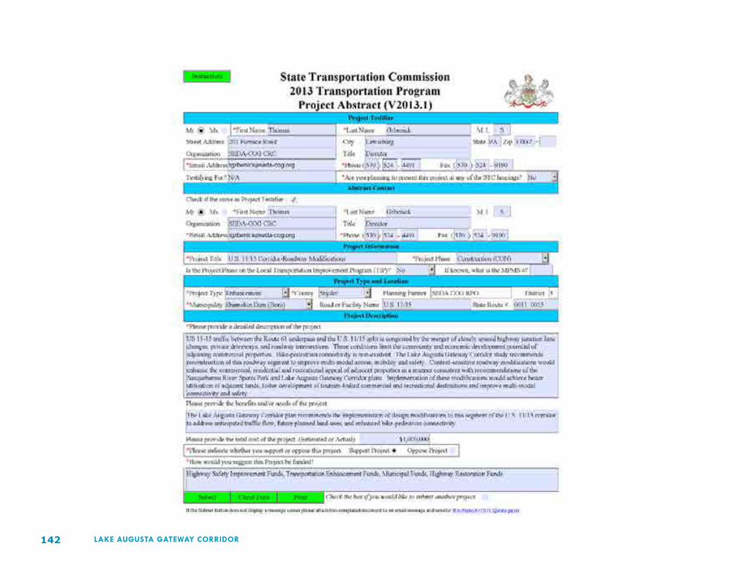
142 LAKE AUGUSTA GATEWAY CORRIDOR

143LAKE AUGUSTA GATEWAY CORRIDOR
