a snapshot of the system - fsn network - dews advancement... · actual disasters, and normally...
TRANSCRIPT

A snapshot of the system
By : Obai Isaac, DRR Specialist ‐ ACTED in Uganda
EARLY WARNING SYSTEM… ⌚This refers to provision of early or relevant information on potential or
actual disasters, and normally involves monitoring hazards, especially in relation to communities vulnerabilities or areas known to be vulnerable to their effects, so that more timely and effective response measures can be taken.
The objective of an EWS is to empower communities threatened by a hazard and decision makers at higher levels, to act in sufficient time and appropriately to reduce the impact of the disaster.
DROUGHT Drought is a condition of moisture deficit sufficient to have an adverse
effect on vegetation, animals, and man over a sizeable areaDrought is a sustained lack of adequate water from established sources to
meet the needs of users.Types of drought: meteorological, agricultural, hydrological

HAZARD
Potentially damaging event, phenomenon or human activity, which may cause the loss of life or injury, property damage, social and economic disruption or environmental degradation
DISASTER
Serious disruption of normal functioning of society causing human, material, or environmental losses exceeds the ability of affected community to cope using own resources.
And the famous… DISASTER RISK REDUCTION … Minimizing vulnerabilities and disaster risks throughout a society, to avoid [prevention] or to limit [mitigation and preparedness], the adverse impacts of hazards, within the broad context of sustainable development.

Risk
H * V
H: HazardV: VulnerabilityC: Capacity
CR =

Population vulnerable to a certain type of disaster
Early Warning System*able to identify in a timely manner any unusual trend*able to answer the questions : what type of disaster?
with which magnitude?how fast is it coming?which area is targeted?
Community informed of the conclusion given by analysis of
the indicators
Institutions informed of the
conclusion given by analysis of the indicators
Rapid response Assessment in the Targeted area
Implementation of response strategy
aiming at reducing the vulnerability of the
population

•Phase 1: Pilot project in 1 district of Karamoja (Nakapiripirit) ‐ 2008
•Phase 2: Design of the regional DEWS ‐ 2009
•Phase 3: Implementation and capacity building – 2009
•Phase 4: Monitoring and technical support ‐ 2010
•Phase 5: Review and adjustments – end 2010
•Phase 6: Implementation of the new adjustments, and innovations to enhancethe timeliness and accuracy of the Drought Bulletin, and continuous monitoringand technical support – 2011
•Phase 7: Continuous monitoring and technical support with focus on enhancingthe capacity of the system to issue accurate and timely messages (EWPC, rainfallobserved data for more reliable weather forecast) and to initiate early action (from thecommunity and LG/partners) – 2012/2013• Phase 8: Handover process to the National and Local government( 2014‐2016)


8
Main sources of IncomeApril 2009
Casual Labour19%
Charcoal 15%
Livestock 44%
Firewood 4%
Honey11%
Crop7%
A first initiative in the region:-Started in June 2008-Inspired from Kenyan EWS (Arid Land)- Data collection in 26 parishes (26 sentinels, including 16 CAHWs)-Monthly Drought Bulletin published -Run by ACTED
County Livelihood Zone Areas Status* Trend
Pian
Agro-pastoralists Lorengedwat, Narisae, Kamaturu, Nathinyoit Alert Improving
Pastoralists
Lorengedwat, Narisae, Kamaturu, Nathinyoit,
Nabilatuk,Alert Improving
Lorengedwat, Kamaturu Alert Improving
ChekwiiAgro-pastoralists Kakomongole, Nabolis Normal No Significant
change
Pastoralists Nabilatuk, Kakomongole, Nabolis Normal No Significant
change
PokotAgro-pastoralists Loroo, Achorichor,
Amudat Alert Improving
Pastoralists Loroo, Achorichor, Amudat Alert Improving
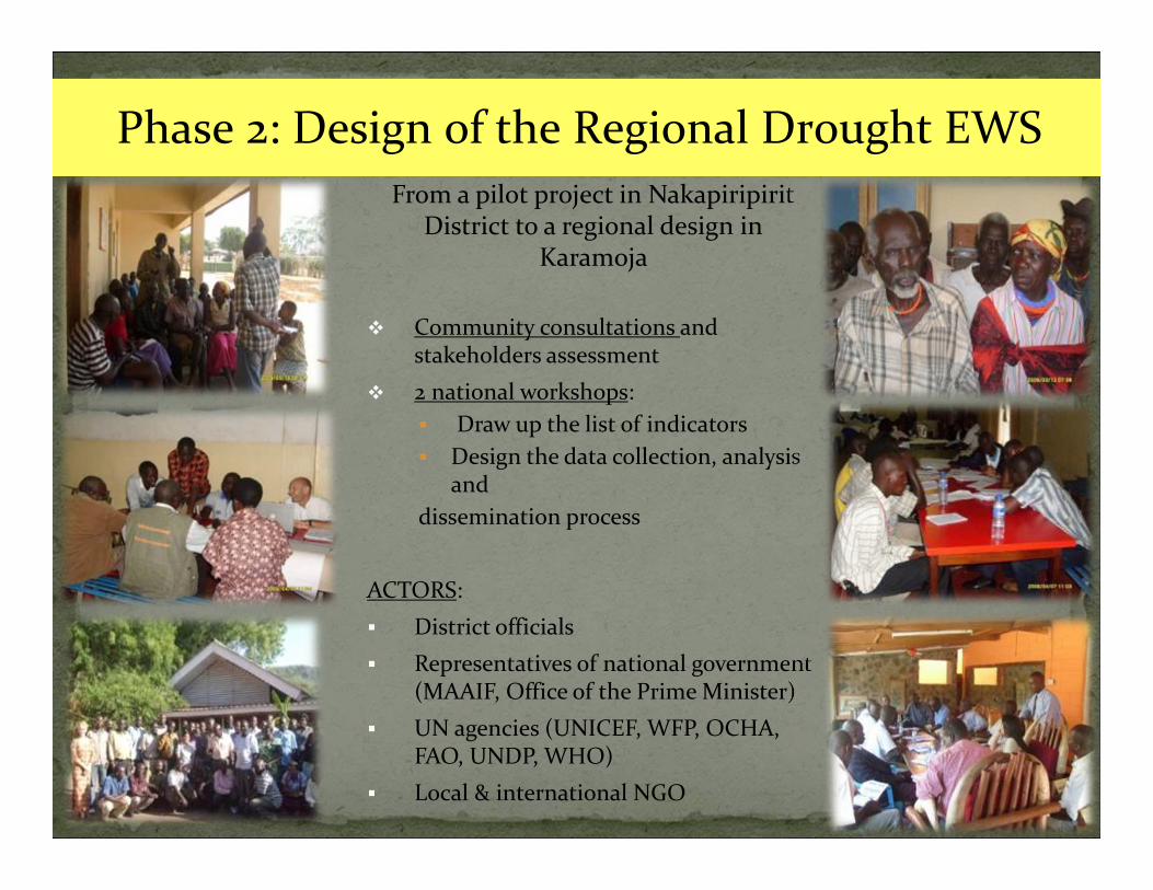
From a pilot project in NakapiripiritDistrict to a regional design in
Karamoja
Community consultations and stakeholders assessment
2 national workshops: Draw up the list of indicators Design the data collection, analysis
and dissemination process
ACTORS: District officials Representatives of national government
(MAAIF, Office of the Prime Minister) UN agencies (UNICEF, WFP, OCHA,
FAO, UNDP, WHO) Local & international NGO 9
Phase 2: Design of the Regional Drought EWS

Project designed in consensus: district officials, representatives of national government (Office of the Prime Minister), UN agencies (UNICEF, WFP, OCHA, FAO, UNDP, WHO), local & international NGO
Government ownership (districts run the project, rely upon existing government institutional structure, national government gives support)
ACTED builds the capacity of the district + national government to run the budget
Low cost project: built under the current resources of the local government
Adapted to the context of Karamoja (list of indicators, chain of communication…though highly inspired from Arid Land, Kenya)
Each district to produce its own Drought Bulletin, OPM to gather/disseminate data at national level
10

11
- Trainings of sentinels, sub-county chiefs, DEWFP- Creation of a EWS Software- Distribution of Equipment (gumboots, bicycles, computers, generators)
Sentinels training, Abim, Aug 09
Sub-County Chiefs training, Kotido, Sept 09
DEWFP training Moroto, Nov 09

12
Field monitoring, Refresher trainings every 6 months (2009/2010)
Sustainability workshop ACTED/OPM/FAO (Jan 2010)
Moroto declaration, circulated at the OPM and office of the 1st Lady

13
By mid of 2010, after 8mth of running the DEWS ACTED identified the following challenges:
Transport of questionnaires: Parish District Slow data entry Lack of data quality control Amount of data (192 Parishes in Karamoja) Some indicators difficult to collect or not reliable enough Software bugs Availability of district Heads of Department for analysis Lack of baseline information and reliable and specific meteorological data No feedback t the communities
The challenges were addressed through: Reviewing the list of DEWS indicators Establishing a sampling framework Introducing new technologies Establishing a data quality control system Supporting the Department of Meteorology EW Phase Classification Radio messages and drama groups
From 36 to 21 indicators
From 192 to 75 representative parishes (and sentinels), covering all
livelihood zones


15
5 sectors:
1. Weather and natural resources
2. Livestock
3. Crop
4. Water
5. Coping strategies/Security/Nutrition
INDICATOR LEVEL OF COLLECTION
HAZARDMONITORINGVegetation Condition HouseholdRainfall Amount DistrictTemperature DistrictHumidity DistrictWeather forecast DistrictVULNERABILITY MONITORINGLivestock Body Condition KraalsLivestock Migration DistrictCalves mortality rate<1mth/abortion KraalsLivestock disease incidence DistrictType and number of livestock available in the market MarketAccessibility of grazing areas KraalsType of crop planted HouseholdCrop condition HouseholdCrop Yield DistrictQuantity of water fetched daily at HH level HouseholdTime spent to fetch water HouseholdType of water sources HouseholdSafe water points DistrictTerm of trade (Price of mature bull/ Price of sorghum) MarketIncidence of malnutrition DistrictOut migration of people LCIFreedom of movement HouseholdCoping mechanisms HouseholdPrice of firewood and charcoal MarketPrice of casual labour HouseholdType of food eaten Household


COLLECT I ON
ANALYS I S
D I SSEM I
NAT I ON
Parish Chiefs District WaterOfficer
District Health Officer
District Veterinary Officer
District EW Focal Person
Data Entry
Drought Bulletin
MAAIF TWG (Reviews
and approves the
bulletins)
Decides if any action plan must be implemented to prevent damages from foreseen drought-Coordinates the response with all other stakeholders
Sub-County Chiefs
District EW Focal Person+ DHO/DWO/DNRO/DAO/DVO
Data Analysis
District Agric Officer
District Natural Resources Officer
OPM-NECOC
Other Line Ministries, stakeholders (NGO’s donors) and DLG’s

Napak, 10
Amudat, 10
Kaabong, 13
Abim, 10
Moroto, 10
Nakapiripirit, 11
Kotido, 11
Distribution of the DEWS sentinels per district

19
HH respondent in Napak district
Head of the HH is interviewed by the Parish Chief who fills in the paper questionnaire
Head of the HH narrates how he narrowly escaped an attack from warriors
Parish Chief fills in the NDG survey and sends it to the server

20
10 HH / sentinel+1 kraal / sentinel+1 market /sentinel=12 questionnaires entered in the phone and sent
Parish55 pilot parishes
District5 pilot districts: Nakapiripirit, Amudat, Napak, Kotido, Kaabong
Analysis by District Heads of Department
Production of the Drought Bulletin
by DEWFP
Data automatically uploaded in DEWS software which produces all graphs of
the Drought Bulletin

Funding from DFID/FAO for implementation of a sustained hand over and ownership of the project by government‐ Involvement of government and streamlining the system into government structures for sustainable functionality
Project to run till January 2016

ACTED to work from within the district and increase contact with the districts
All modalities of communication to be within the government processes
Support from ACTED should be in line with what Government demands in order to run the system
Capacity Building of the District and National government priority
Early Action pilot in one district of Karamoja
