a stratigraphic framework for the catskill facies, southeastern new york and northeastern...
TRANSCRIPT
A Stratigraphic Framework for the Catskill Facies, Southeastern New York and Northeastern Pennsylvania
Frank W. Fletcher, 4 Thompson Court, Reedville, VA, [email protected]
THE CATSKILL DELTA
JOSEPH BARRELL wrote the first comprehensive description of the thick wedge of Middle and Upper Devonian clastic rocks known as the Catskill Delta in 1913. Since that time the stratigraphy, sedimentology, and paleontology of these rocks have been the subject of countless publications, including two notable overviews: Shepps (ed.), 1963, and Woodrow and Sevon (ed.), 1985. The stratigraphic relations of the Catskill Delta are well illustrated on correlation charts published by the geologic surveys of New York (Rickard, 1975) and Pennsylvania (Berg and others, 1983).
Research Poster Design Services
How to order your poster for printing
The sedimentary sequence of the Catskill Delta consists six major clastic facies, representing six discrete environments of deposition associated with the filling of the Appalachian foreland basin during the Devonian Period.
“Any geologist who has followed this series of rocks from central New York eastward to the Catskills, and then along their eastern slope into Pennsylvania, knows very well that red beds appear at different horizons in various parts of the area, and also realizes the utter impossibility of indicating the same approximate horizon by drawing a line through the lowest red beds.” C. S. Prosser, 1894.
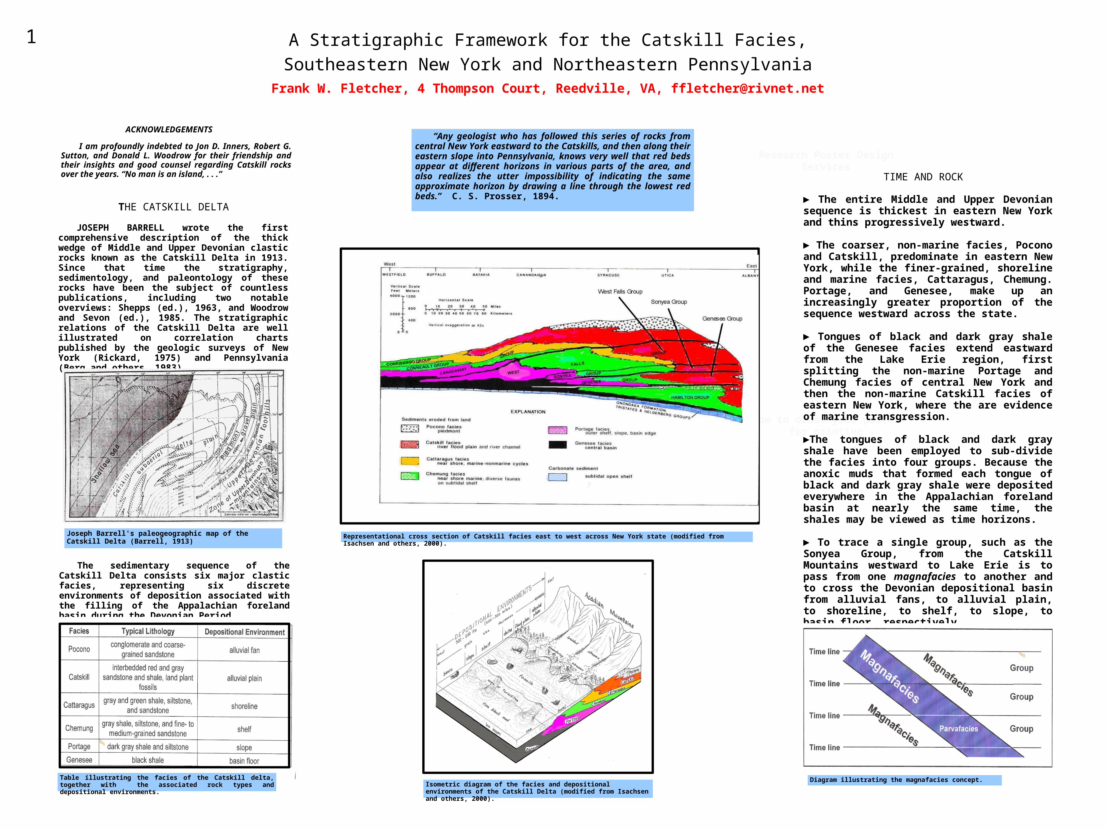
TIME AND ROCK ► The entire Middle and Upper Devonian sequence is thickest in eastern New York and thins progressively westward.
► The coarser, non-marine facies, Pocono and Catskill, predominate in eastern New York, while the finer-grained, shoreline and marine facies, Cattaragus, Chemung. Portage, and Genesee, make up an increasingly greater proportion of the sequence westward across the state.
► Tongues of black and dark gray shale of the Genesee facies extend eastward from the Lake Erie region, first splitting the non-marine Portage and Chemung facies of central New York and then the non-marine Catskill facies of eastern New York, where the are evidence of marine transgression.
►The tongues of black and dark gray shale have been employed to sub-divide the facies into four groups. Because the anoxic muds that formed each tongue of black and dark gray shale were deposited everywhere in the Appalachian foreland basin at nearly the same time, the shales may be viewed as time horizons.
► To trace a single group, such as the Sonyea Group, from the Catskill Mountains westward to Lake Erie is to pass from one magnafacies to another and to cross the Devonian depositional basin from alluvial fans, to alluvial plain, to shoreline, to shelf, to slope, to basin floor, respectively.
Joseph Barrell's paleogeographic map of the Catskill Delta (Barrell, 1913)
Representational cross section of Catskill facies east to west across New York state (modified from Isachsen and others, 2000).
Isometric diagram of the facies and depositional environments of the Catskill Delta (modified from Isachsen and others, 2000).
Table illustrating the facies of the Catskill delta, together with the associated rock types and depositional environments.
Diagram illustrating the magnafacies concept.
1
ACKNOWLEDGEMENTS
I am profoundly indebted to Jon D. Inners, Robert G. Sutton, and Donald L. Woodrow for their friendship and their insights and good counsel regarding Catskill rocks over the years. “No man is an island, . . .”

Stratigraphic ExplorationsThe Search for a Paradigm
paradigm: a set of assumptions, concepts, values and practices that constitutes a way of viewing reality for the community that shares them, especially in an intellectual discipline.
During the first Geological Survey of New York (1836-1843), WILLIAM W. MATHER employed the name Catskill to denote the red strata found in the Catskill Mountains. Together with his colleagues James Hall and Lardner Vanuxem, Mather assembled one of the famous rock sequences of the eastern United States: (in ascending order) Genesee, Portage, Chemung, and Catskill.
Although revision of Upper Devonian stratigraphy had already begun by the beginning of the 20th century, not until the 1930's did geologists fully understand that the Genesee, Portage, Chemung, and Catskill rocks of New York did not lie one above another in a stacked sequence but were inter-tonguing facies. Chief among the pioneers of the new paradigm were George H. Chadwick and G. Arthur Cooper in New York and Bradford Willard in Pennsylvania
CatskillChemungPortage
Genesee
MarcellusHamilton
Onondaga
Lake Erie Catskill Mtns
Tully
In Pennsylvania 19th Century geologists also recognized a “layer-cake” model for the Genesee, Portage, Chemung, and Catskill sequence; although debates about Portage-Chemung relationships raged into the 20th Century. I. C. WHITE (1881,1882) subdivided the Catskill in northeastern Pennsylvania into eight “members.” White believed that the boundary between the Chemung and Catskill occurred at the same stratigraphic level everywhere in the region, and that the younger units were stacked up in order above it. He did not, however, illustrate these subdivisions on his geologic maps of Susquehanna, Wayne
WILLARD (1939) lucidly documented the facies changes of Devonian rocks across Pennsylvania and the Upper Devonian lithologies involved in the Catskill offlap.
The publication of STATE GEOLOGIC MAPS, in New York (Fisher and others, 1970) and Pennsylvania (Berg and others, 1980), brought forth two very different views of the Catskill sequence. The authors of the Geologic Map of New York State divided the Catskill facies into five time-rock units totaling over 3,500 feet and mapped these across of broad region of southeastern New York. The geologists of the Pennsylvania Geologic Survey, however, illustrated this series of rocks throughout northeastern Pennsylvania as a single, monochromatic formation.
and Pike Counties, which displayed only vast expanses of the “Catskill formation.”
“Layer-cake” model of the New York Middle and Upper Devonian.
I. C. White's geologic map of Wayne County, Pennsylvania.
But in northeastern Pennsylvania, Willard adopted much of White’s flawed stratigraphic column and terminology and, like White, pictured the subdivisions of the Catskill as discrete layers stacked up like pancakes. Willard further confused the geologic picture by constructing a geologic map that displays these (fictitious) units as concentric bands about the Lackawanna syncline.
PRESENT AT THE CREATION
MULTIPLE WORKING HYPOTHESES
CHADWICK proposed a radical division of the Catskill red beds into several chronostratigraphic units. Although his terminology was later abandoned, he produced the first geologic map showing individual Catskill formations and their marine equivalents in southeastern New York. He also drew attention to serious errors in I. C. White's Catskill stratigraphy, pointing out that it was “scrambled.”
CATSKILL
FORMATION
2
Chadwick's geologic map of southeastern New York (modified from Chadwick, 1936).
Schematic east-to-west cross section of the Catskill offlap (modified from Willard, 1939.
Willard's geologic map of northeastern Pennsylvania (Willard, 1938).
Geologic map of southeastern New York (modified from Rogers and others, 1990).
Geologic map of northeastern Pennsylvania (modified from Miles, 2003).
CATSKILL FACIES

REFERENCES
WALLACE DEWITT, JR. and GEORGE W. COLTON of the USGS and ROBERT G. SUTTON and his students at The University of Rochester demonstrated that the black and dark gray shale tongues split the Portage and Chemung (marine) facies of south-central New York and form the basis for the defining the principal rock units (groups)--the Genesee, Sonyea, and West Falls Groups of the Upper Devonian Frasnian Stage (see Rickard, 1975). Sutton (1963) traced dark gray shales of the Rhinestreet Formation eastward into the Walton Formation of the Catskill facies.
SUBDIVIDING THE CATSKILL FACIES“The key to unraveling the complex facies that occur in this part of the Devonian has proven to be the tracing of the black or dark gray shale tongues that persist eastward across the major facies boundaries.” L.V. Rickard, 1975
FRANK W. FLETCHER and DONALD L. WOODROW (1964, 1970, and 2002) identified dark gray shale tongues of the Middlesex and Rhinestreet Formations among Catskill strata in exploratory gas wells and in outcrop at several localities in northeastern Pennsylvania. WALTER R. WAGNER (1963) of the Pennsylvania Geologic Survey, employing lithic and gamma-neutron logs of five gas wells, traced dark shale horizons in the subsurface through the Catskill facies of northeastern Pennsylvania.
Middle and Upper Devonian Stratigraphyof the Upper Delaware River Valley
Employing well data from Rickard (1989), a structure contour map of the top of the Tully-Gilboa interval, shown below, was constructed for this study. The map illustrates a broad syncline underlying a large portion of southeastern New York and plunging toward the southwest into northeastern Pennsylvania. Further, it demonstrates that the regional strike of the Upper Devonian strata of Delaware County (N.Y.) and northern Wayne County (Pa.) is roughly east to west, fully perpendicular to the strike orientation indicated by Willard and displayed on his geologic map. Evidently, any structural influence that the Lackawanna syncline may have on the rocks of the region is largely local.
The current study of the Catskill facies in the upper Delaware River valley utilized subsurface information derived from a reexamination of lithic logs originally described by Fletcher (1964) and augmented by additional data from Fletcher and Woodrow (1970) and Rickard (1975, 1989). The cross section displayed below demonstrates that more than 5,000 feet of rock overlie the Tully-Gilboa in this region. The sequence includes strata belonging to the Genesee, Sonyea, and West Falls Groups.
Dark gray shale tongues, representing members of the Geneseo, Middlesex, and Rhinestreet Formations, extend south-eastward from the Upper Devonian marine facies in Broome County, N. Y. and provide a basis for extending the Genesee, Sonyea, and West Falls Groups from south-central New York to eastern Pike County, Pennsylvania.
Berg , T., and others, 1983, Stratigraphic correlation chart of Pennsylvania: Pennsylvania Geological Survey General Geology Report 75.Chadwick, G. H., 1936, History and value of the name “Catskill” in Geology:
New York State Museum Bulletin no. 307.Fisher, D. W., and others, 1970, Geologic map of New York State: New York
State Museum Map and Chart Series No. 15.Fletcher, F. W., 1963, Regional stratigraphy of Middle and Upper Devonian
non-marine rocks in southeastern New York: p. 25-42, in Shepps, V. C.---------- 1964, Middle and Upper Devonian stratigraphy of southeastern New
York: unpublished Ph.D. Thesis, The University of Rochester.Fletcher, F. W., and Woodrow, D. L., 1970, Geology and economic resources of
the Pennsylvania portion of the Milford and Port Jervis 15-minutequadrangles: Pennsylvania Geological Survey Atlas 223.
Isachsen, Y. W. and others, 2000, Geology of New York: A simplified account(2nd ed.): New York State Museum Educational Leaflet 28.
Miles, C. E. (compiler), 2003, Geologic shaded-relief map of Pennsylvania:Pennsylvania Geological Survey.
Prosser, C. S., 1894, The Devonian System of eastern Pennsylvania and NewYork: U. S. Geological Survey Bulletin 120.
Rickard, L. V.,1975, Correlation of Devonian rocks of New York State: NewYork State Museum Map and Chart Series No. 24.
----------, 1989, Stratigraphy of the subsurface Lower and Middle Devonian ofNew York, Pennsylvania, Ohio, and Ontario: New York State Museum
Mapand Chart Series No. 39.
Rogers, W. B., and others, 1990. New York State geological highway map:New York State Museum Educational Leaflet 33.
Shepps, V. C., 1963, Symposium on Middle and Upper Devonian stratigraphyof Pennsylvania and adjacent states: Pennsylvania Geological SurveyGeneral Geology Report 30.
Sutton, R. G. 1963, Correlation of Upper Devonian strata in south-central NewYork: p. 87-102, in Shepps, V. C.
Sutton, R. G., and McGhee, Jr., 1983, The evolution of Frasnian marine“community-types of south-central Hew York: p. 211-224, in Woodrow, D.L., and Sevon, W. D.
Wagner, W. R., 1963, Correlation of Susquehanna Group in part ofnortheastern Pennsylvania, p. 63-78, in Shepps, V. C.
White, I. C., 1881, The geology of Susquehanna and Wayne Counties:Pennsylvania Geological Survey Report G 5.
Willard, B., 1939, The Devonian of Pennsylvania: Pennsylvania GeologicalSurvey Bulletin G 19.
Woodrow, D L., and Fletcher, F. W., 2002, Late Devonian stratigraphy innortheastern Pennsylvania: in Inners, J. D. and Fleeger, G. M. (eds.),
FromTunkhannock to Starrucca: Guidebook. 67th Annual Field Conference ofPennsylvania Geologists.
Woodrow, D. L., and Sevon, W. D., 1983, The Catskill Delta: GeologicalSociety of America Special Paper 201.
The Frasnian stratigraphic record of south-central New York (modified from Sutton and McGhee, 1983, after Rickard, 1975).
Stratigraphic relation of red beds to gamma ray correlation lines within the Catskill facies of northeastern Pennsylvania (modified from Wagner, 1963). See profile D-E of the index map.
Computer-generated, contour map of the top of the Tully-Gilboa interval in southeastern N. Y. and northeastern Pa. (contours in feet).
Index map to wells and profiles.
Stratigraphic column illustrating the Middle and Upper Devonian units of southeastern New York and northeastern Pennsylvania.
Cross section from Whitney Point (Broome County), N. Y. to Shohola (Pike County), Pa. illustrating the stratigraphic intervals of the post-Tully (Late Devonian) sequence. Stratigraphic nomenclature for the rocks of the Shohola region is based on Fletcher and Woodrow, 1970), while the nomenclature of the Whitney Point rocks is after Rickard, 1975.
A STRATIGRAPHIC FRAMEWORK FOR THE INTERPRETATION OFCATSKILL SEQUENCES AND PALEOENVIRONMENTS
3
The Lackawaxen Formation represents the west-ward extension of the Slide Mountain Formation, which caps the highest peaks of the Catskill Mountains, and is the non-marine equivalent of the Rhinestreet shales. The Stockport Formation can be correlated with the Gardeau Formation, while the “Damascus” and “Honesdale” intervals are correla-tives of the Nunda and Wiscoy Formations.