a version of this paper was sbmitted to the journal of...
TRANSCRIPT
ARCHAEOLOGICAL INVESTIGATIONS AT MOCCASIN ISLAND, BRUSH POND, COLBERT COUNTY, ALABAMA (See inset photo)
A version of this paper was sbmitted to the Journal of Alabama Archaeology.
Richard Michael Gramly
Brush Pond is a small natural lake set within a rolling, karstic plain, 500-700 feet in altitude, southeast of Tuscumbia and Muscle Shoals, Colbert County, Alabama. Brush Pond lies 1 ½ miles southeast of the small town of Leighton and not far from old Route 20, a major east-west artery (Figure 1). When completely full, waters might cover 1000-1200 acres; however, in the modern day its size is seldom half that figure. During prolonged drought the lake nearly disappears, and open water is nowhere to be found. Even during the driest periods, however, a swamp or wetland persists in the northeast quarter of the lake basin. It becomes a refuge for aquatic and water-adapted species (such as cottonmouth water moccasins, copperheads, and canebrake rattlesnakes), who repopulate the main lake when waters rise. Notable geographic features of the Brush Pond basin are a forested peninsula trending southeast-northwest that nearly bisects the lake and a rocky islet, which we have dubbed Moccasin Island (Figure 2). Moccasin Island is roughly oval, only 45-55 m in width, and almost level. A limestone substrate (Tuscumbia Formation) is covered by a blanket of red-colored clay that was deposited during a very high stand of the lake. Until recently both the peninsula and island were used seasonally by the Gordon Fennel family as a hunting preserve. Ducks and deer were the principal quarry. A small cabin on the peninsula, known as the “Duck Camp,” provided lodging to hunters who used a duck hunting blind on Moccasin Island. Neither the peninsula nor the island within Brush Pond have been farmed or heavily timbered. As a result, ancient stone artifacts may be picked from the surface or are only shallowly buried. Archaeological testing during November, 2012, by Michael McNew and Dave Martens -- both Members of the American Society for Amateur Archaeology -- revealed abundant flaked stone artifacts, rough stone tools, and fire-cracked rock near the Duck Camp and the hunting blind at Moccasin Island. Their discoveries were followed up by 20 days of exploration in 2013 and 2014. Two days were also spent on the island during May, 2015. This report summarizes the 2012-2015 fieldwork and discusses the significance of the data. For the immediate region, that is to say, Colbert County and the Tennessee River lowland, Brush Pond is hardly unique. Several other karstic basins with fluctuating water levels, rimmed by prehistoric vestiges, are known – an example being the Sixth Street Site (aka Heaven’s Half Acre), which lies several miles to the northwest (King 2007). Brush Pond’s special claim, however, is its two, unmolested prehistoric sites. Elsewhere within the region generations of collectors have scoured fields and forests for artifacts, nearly effacing traces of encampments and making cultural assignation and dating difficult. Moccasin Island and the Duck Camp peninsula have been spared such attention by their reputation as the haunt of venomous snakes. Based upon our experiences, this reputation is well deserved. Five kilometers (three miles) to the southwest of Brush Pond rises LaGrange Mountain, which is 300-400 feet above the general elevation (Figure 1). Rockshelters on the mountain have been explored by professional and amateur archaeologists. One of them, LaGrange Rockshelter, yielded abundant Very Early Archaic remains and evidence of seed processing. It has been suggested that seeds may have been gathered around Brush Pond or from some other “seasonally
disturbed setting” within the rockshelter’s neighborhood (Hollenbach 2009: 221). Such a suggestion is reasonable in light of the discoveries we made at Moccasin Island, as described below.
Objectives of the Research at Brush Pond In quest of artifacts of the Cumberland archaeological culture, the author and colleagues were guided to Brush Pond by Florence resident, Charles Moore, who had discovered a rare Early Stage Cumberland fluted point 30-40 feet above the usual stand of the lake (Gramly 2012: Figure 39). Its find-spot lies 15-20 feet higher than sites with Clovis remains. Compared to Cumberland, Clovis flaked stone artifacts seem relatively abundant around the margin of the Brush Pond basin. It is possible that Clovis settlements once occupied beachside locations. In order to test our idea that Clovis vestiges are confined to the margin of Brush Pond basin at least 15-20 feet above the current lake stand, it was necessary to explore sites directly upon the modern shore. Moccasin Island and the Duck Camp peninsula offered excellent prospects for systematic excavation. Permission for fieldwork was given by the Fennell family, and we are grateful to them and to other friends in Florence, Alabama for their continued cooperation. A primary objective was to ascertain the oldest projectile point to be found at Moccasin Island and the Duck Camp. A generous sample of projectile points (75-150) of recognizable type and form obtained over a wide, excavated area, was needed to accomplish our objective. Initial excavations along the Duck Camp peninsula did yield Early Archaic bifaces, but not in the quantity we sought; therefore, our operation shifted to Moccasin Island where remains more concentrated -- offering a richer return for the time and labor we were prepared to invest in this project. A secondary objective was to learn something about the ancient economy of Moccasin Island’s inhabitants. We wished to know what plants and animals were important in the diet, and was there any evidence of a seasonal occupation?
Excavation Strategy and Field Methods The 2012 preliminary test-pitting by McNew and Martens, which covered an area of only six square meters, had been confined to a small opening within the underbrush near the Fennell’s hunting blind (Figures 3 and 4). In 2013 we extended this area 20 m to the south by removing a noxious growth of greenbrier, ivy, and vines. Within this large space we established the N-S line (length 46 m) of our excavation grid. Several 2-m squares (A-D) and half-squares (E-H) were laid out for investigation (Figure 5). We were surprised to observe snakes lying several feet off the ground within rank vegetation; caution was demanded of our party during every phase of this initial fieldwork. In subsequent seasons (2014 and 2015) an E-W trench of contiguous 2-m squares (I-S) was laid out at a right angle to the units that were explored during 2013. In addition, three outlying units (2-m squares Q, T and U) were dug. Altogether, we completed 21 units during the 2013-2015 field seasons covering a total of 82 square meters. Including the 2012 test-pitting, I estimate barely five per cent (5%) of Moccasin Island’s surface was investigated – leaving a large reserve of untapped data for future researchers. As the reader may judge from Table 1, the size of our artifact sample from Moccasin Island was sufficiently large to ascertain what are the oldest projectile point types around the shore of modern Brush Pond. These types are Quad and Dalton; examples are figured below. It was immediately evident to us excavators that archaeological deposits across the island were confined to a ground midden, which had been churned thoroughly by the people who
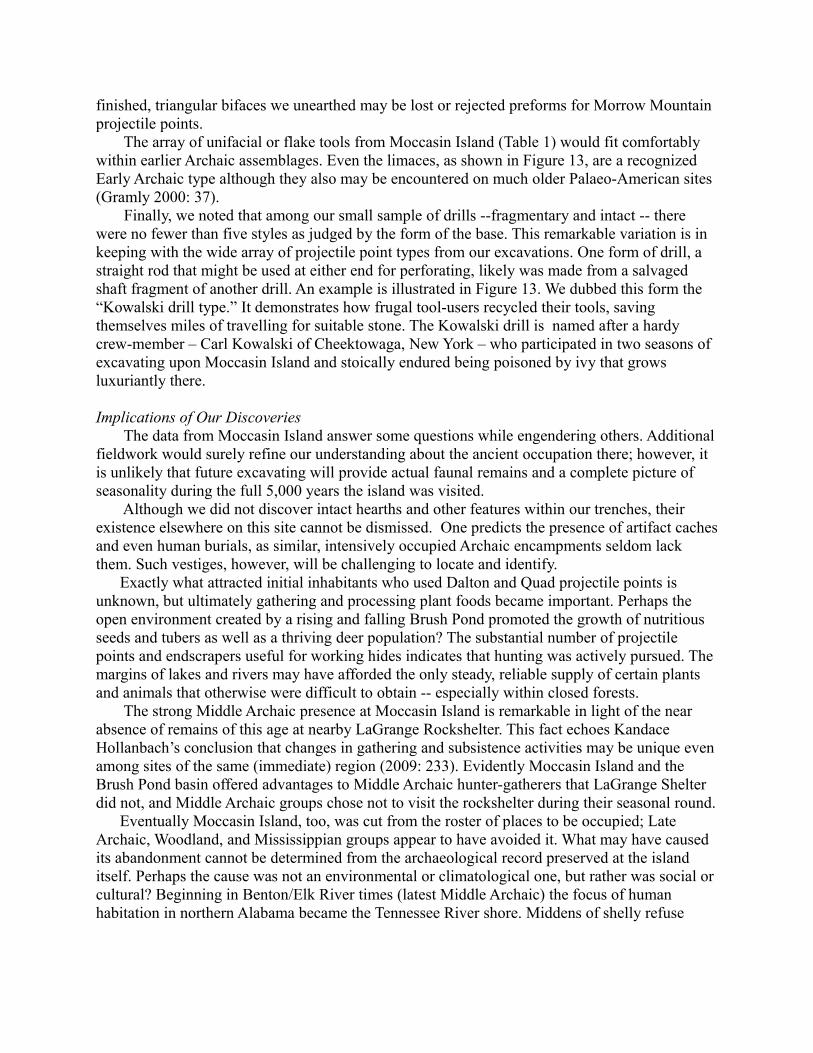
created it as well as by plants and animals who lived there subsequently. The midden, 25-30 cm thick, was unstratified with artifacts of different ages co-mingled. There was no meaningful differentiation among archaeological cultures and phases according to depth below surface. At the very least we hoped to discover some areal (horizontal) patterning of cultural remains; however, no spatial segregation of artifact types was apparent. After an initial effort to excavate by layers (spits) of arbitrary thickness and to plot artifacts by horizontal co-ordinates, we removed the ground midden within each grid unit as a whole, passing everything through a ¼-inch (6 mm) mesh, and collecting all rock – debitage, flaked stone tools, rough stone tools, and fire-cracked rock. The midden was everywhere brown in color and was composed of the original lake clay interspersed with artifacts and other rock manuports, charcoal, and particles of baked (fire-reddened) soil. The latter represented hearth basins and other cooking features that had disappeared due to bio-turbation. The midden rested upon a sticky, and archaeologically sterile, red-colored clay, which in turn, overlay limestone bedrock 60-80 cm below surface. As presented in Table 2, the density of flaked stone debitage ranged from a low of 40 items per square meter of ground midden to as many as 465 items per square meter. The average yield across the entire excavation was 180-185 flakes per square meter. The highest yields (within 2-m squares O, Q and U) resulted from sieving that we carried out in the lake. Wet-sieving made flakes much easier to spot upon the wire mesh and recovery was better than by dry-sieving. A total of 14,598 debitage flakes, weighing approximately 36 kg,was obtained in the course of our 2012-2015 fieldwork. Considering that our excavations encompass hardly 1/20 of the archaeological deposit on Moccasin Island, there remain nearly 275,000 flakes to recover. The estimated weight of the unexcavated flake mass is 675 kg or slightly less than 1 1/2 tons! This figure, however, is but a small fraction of the weight of fire-cracked rock that was left behind at the island by ancient visitors. A minimum estimate of this residue from cooking and heating is 40-45 tons. Undoubtedly much of it was brought from a considerable distance – carried either within a canoe or a pack-basket. Every unit of our excavation yielded fire-cracked rock. Quantities ranged from 5 to 20 gallons, although Unit Q contained 85 gallons – truly an exceptional amount constituting half the volume of this unit. A close watch was kept for postholes and other features that extended below the ground midden into the stiff, reddish lake clay. None were observed across the floor of the entire excavation. Likewise, we were alert to the presence of ancient faunal remains (bone, antler, shell), but nary a scrap came to light upon our sieves. While the lack of archaeological features may be explained by unyielding, almost elastic, lake clay, the absence of fauna is more difficult to understand. The age of the Moccasin Island site coupled with aeration, exposure to the elements and scavengers, plus chemical weathering all may have had a role in dissolution of faunal remains.
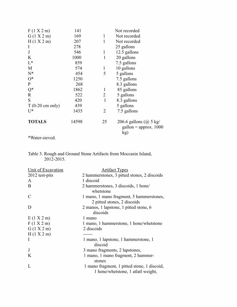
Details about the Artifact Assemblage Apart from expected discoveries of flaked stone tools, debitage flakes and cores, and a mass of fire-cracked rock, the most remarkable finds in our Moccasin Island excavations were rough and ground stone implements (Table 3). The large quantity of handstones or manos, in particular, was a surprise, and I had never witnessed so much from so small a volume of archaeological deposit. There were 12 complete manos and 18 large fragments (Figure 6). Sixteen of the 21 units produced them. There were also six lapstones or mortars (Figure 7) that
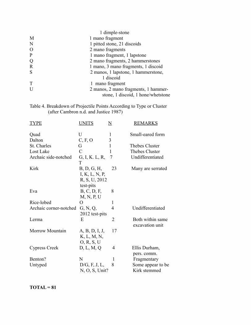
may have been used in conjunction with manos. Undoubtedly some of the 17 hammerstones recovered by us had been used to dress these stones to make them better grinding implements. Eight pitted stones (Figure 8), a few with more than one pit upon a face, and four hones or whetstones complete the inventory of rough stone tools. Undoubtedly the total count of these rough stone artifact types would swell if the multitude of small fragments that we unearthed could be reassembled and identified. Many rough stone tools had been incorporated within campfires and cooking features, causing them to be shattered. The only obvious clustering of rough stone tools in our excavations was a group of hammerstones within unit C and clusters of discoids within units D and N. For what purpose discoids (Figure 9) were used is unknown. Most are nothing more than flat, round pebbles that were selected for size and shape; a few appear to have been minimally shaped. I have observed clusters of pebbles at archaeological sites elsewhere in North America (for example, Gramly 2001: Figure 1), and I prefer to interpret them as children’s playthings. The manos/metates and pitted stones suggest that plant foods were important in the diet of Moccasin Island’s inhabitants. The question is: When during the lengthy timespan of the island’s occupation were these plant processing artifacts used? Typed projectile points (see Table 4) span the Very Early Archaic (11,000-11,500 calendar years before present) through various phases of the Middle Archaic (7,000-6,500 calendar years before present) or, roughly, 5,000 years. This period is the Hypsithermal or Altithermal Interval, when in some regions of North America climate was warmer than today and droughty. Over 5,000 years, changes in diet and food-preparation would be expected. While pitted stones are known for the entire era, manos and metates appear to be rare or absent on Very Early Archaic and Early Archaic sites of the south-central United States. Alas, the shallow ground midden at Moccasin Island with its jumble of Archaic artifacts, does not allow us to differentiate occupation phases. Therefore, there is no trustworthy association of grinding tools with any specific projectile point type. Only two ground stone artifacts were recovered by us; both are from Unit L. They are illustrated in Figure 10. The unfinished “dimple-stone” made of sandstone is a small-sized example of this rare class of artifacts that is widespread in southern and south-central North America (Rachels and Knight 2004). Although few dimple-stones have ever been excavated or directly dated, they are thought to have been used during the Early Archaic period. The unfinished bannerstone of weathered argillaceous raw material appears to have seen secondary service as a hammerstone. It would have been an ideal percussor for trimming flaked stone tools. Although fragmented, the bannerstone from Moccasin Island likely belongs to one of the most ancient styles, which is known to be associated with Kirk projectile points (Lutz 2000: 128). The 81 fragmentary and complete flaked stone projectile points that we recovered in 2012-2015 from Moccasin Island are presented according to type or “cluster” in Table 4. Selected specimens from this group are illustrated in Figures 11 and 12. A wide range of types is evident with varieties of Kirk points and Morrow Mountain points being numerically most important. Most of the points have been fashioned of regionally available Ft. Payne chert. A few of the Morrow Mountain type, however, are made of white, pink, orange and red cherts that are commonly encountered on sites in northern Mississippi and adjacent Tennessee. Likewise, several triangular bifaces with excurvate bases (for example, the specimen illustrated in Figure 13) were flaked of such chert. Presumably these triangular bifaces are knives dating to the Middle Archaic period and are associated with the Morrow Mountain type. The less well
finished, triangular bifaces we unearthed may be lost or rejected preforms for Morrow Mountain projectile points. The array of unifacial or flake tools from Moccasin Island (Table 1) would fit comfortably within earlier Archaic assemblages. Even the limaces, as shown in Figure 13, are a recognized Early Archaic type although they also may be encountered on much older Palaeo-American sites (Gramly 2000: 37). Finally, we noted that among our small sample of drills --fragmentary and intact -- there were no fewer than five styles as judged by the form of the base. This remarkable variation is in keeping with the wide array of projectile point types from our excavations. One form of drill, a straight rod that might be used at either end for perforating, likely was made from a salvaged shaft fragment of another drill. An example is illustrated in Figure 13. We dubbed this form the “Kowalski drill type.” It demonstrates how frugal tool-users recycled their tools, saving themselves miles of travelling for suitable stone. The Kowalski drill is named after a hardy crew-member – Carl Kowalski of Cheektowaga, New York – who participated in two seasons of excavating upon Moccasin Island and stoically endured being poisoned by ivy that grows luxuriantly there.
Implications of Our Discoveries The data from Moccasin Island answer some questions while engendering others. Additional fieldwork would surely refine our understanding about the ancient occupation there; however, it is unlikely that future excavating will provide actual faunal remains and a complete picture of seasonality during the full 5,000 years the island was visited. Although we did not discover intact hearths and other features within our trenches, their existence elsewhere on this site cannot be dismissed. One predicts the presence of artifact caches and even human burials, as similar, intensively occupied Archaic encampments seldom lack them. Such vestiges, however, will be challenging to locate and identify. Exactly what attracted initial inhabitants who used Dalton and Quad projectile points is unknown, but ultimately gathering and processing plant foods became important. Perhaps the open environment created by a rising and falling Brush Pond promoted the growth of nutritious seeds and tubers as well as a thriving deer population? The substantial number of projectile points and endscrapers useful for working hides indicates that hunting was actively pursued. The margins of lakes and rivers may have afforded the only steady, reliable supply of certain plants and animals that otherwise were difficult to obtain -- especially within closed forests. The strong Middle Archaic presence at Moccasin Island is remarkable in light of the near absence of remains of this age at nearby LaGrange Rockshelter. This fact echoes Kandace Hollanbach’s conclusion that changes in gathering and subsistence activities may be unique even among sites of the same (immediate) region (2009: 233). Evidently Moccasin Island and the Brush Pond basin offered advantages to Middle Archaic hunter-gatherers that LaGrange Shelter did not, and Middle Archaic groups chose not to visit the rockshelter during their seasonal round. Eventually Moccasin Island, too, was cut from the roster of places to be occupied; Late Archaic, Woodland, and Mississippian groups appear to have avoided it. What may have caused its abandonment cannot be determined from the archaeological record preserved at the island itself. Perhaps the cause was not an environmental or climatological one, but rather was social or cultural? Beginning in Benton/Elk River times (latest Middle Archaic) the focus of human habitation in northern Alabama became the Tennessee River shore. Middens of shelly refuse
proliferated; rich deposits of Late Archaic artifacts were laid down along the River and its major tributaries. A widespread trade or exchange in articles from afar becomes evident. The groups who once ranged the hinterlands of southern Colbert County, too, may have gravitated towards river routes of communication and looked outside the region for ideas and innovations. Whatever was the cause, human occupation at Moccasin Island ceased abruptly, and interest in the Brush Pond basin lapsed. The principal inhabitants then became the deer, the turtle, and the serpent. Acknowledgements I wish to thank the following 27 volunteers, most of whom are (were) Members of the American Society for Amateur Archaeology, for their work around Brush Pond and for their forbearance: Steve Aldred (and Diane); Jerry and Hariett Botdorf; Roger Breton; Ricky Findlay; the late John Hill; Tim Johnson; Robert Knight; Carl Kowalski; Grace Lawrence; Greg Lott; Dave Martens; Roy McKey; Mike and Elaine McNew; Nick and Cindy Miller; Nancy Moore; Don Munroe; Richard Sojka; Denis Timko; Dennis Vesper; Dave Webb; Brian Wood; Tim Yokum; and Wendy Zebehazy.
References Cited
Cambron, James W. n.d. (reprint of the original publication) A Field Guide to Southeastern Point Types. Decatur, Alabama.Durham, Ellis 2011 (personal communication) Benton interaction sphere – comments upon an article by Charles McNutt et al.Gramly, Richard Michael 2000 Guide to the Palaeo-American Artifacts of North America. Persimmon Press. Buffalo, New York. 2001 Recent excavations at the Bartush Ranch, Red River region, Texas. The Amateur Archaeologist 7(2): 21-39. 2012 Bifaces of the Cumberland Tradition. Persimmon Press. North Andover, Massachusetts. 2015 An archaeological test-trench on Moccasin Island, Colbert County. Stones & Bones 57(2): 2-4.Hollenbach, Kandace D. 2009 Foraging in the Tennessee River Valley. The University of Alabama Press. Tuscaloosa.Justice, Noel D. 1987 Stone Age Spear and Arrow Points. Indiana University Press. Bloomington. King, Howard 2007 Heaven’s Half Acre: A Northwest Alabama Paleo-Indian complex. Stones & Bones 49(4): 1-9. Lutz, David L. 2000 The Archaic Bannerstone: Its Chronological History and

Purpose from 6000 B.C. to 1000 B.C. Newburgh, Indiana.Rachels, Thomas and Robert L. Knight 2004 Dimple stones – an unique and early ground stone artifact type. The Amateur Archaeologist 10(2): 57-76. Note: The bulk of the catalogued artifact assemblage and a sample of debitage flakes from Moccasin Island excavations along with notes, photographs and original artwork have been deposited with Charles E. Moore for the Indian Mound Museum, Florence, Alabama.
Table 1. Flaked Stone Artifacts (No Debitage) from 2012-2015 Excavations at Moccasin Island, Colbert County, AL.
A. Utilized flakes 225B. Bifaces/biface fragments 163 (not projectile points)C. Projectile points/fragments 148 1. Intact and basal..81 2. Medial..33 3. Tip..34D. Endscrapers 31E. Irregular scrapers & rabots 20F. Drills/drill fragments 19G. Limaces 5H. Adzes/celts 3I. Gravers 3J. Pieces esquillees 3K. Sidescrapers 3L. Denticulates 2M. Tool fragments 29 TOTAL 654
Table 2. Tallies of Debtitage and Fire-Cracked Rock, 2012-2015
Excavation Unit Debitage Flakes Cores Fire-cracked Rocks
2012 test-units 204 4 Not recordedA (all spits) 864 1 Not recordedB 865 Not recordedC 1076 1 Not recordedD 1086 3 Not recordedE (1 X 2 m) 79 Not recorded
F (1 X 2 m) 141 Not recordedG (1 X 2 m) 169 1 Not recordedH (1 X 2 m) 207 1 Not recordedI 278 25 gallonsJ 546 1 12.5 gallonsK 1000 1 20 gallonsL* 859 7.5 gallonsM 574 1 10 gallonsN* 454 5 5 gallonsO* 1250 7.5 gallonsP 268 8.3 gallonsQ* 1862 1 85 gallonsR 522 2 5 gallonsS 420 1 8.3 gallonsT (0-20 cm only) 439 5 gallonsU* 1435 2 7.5 gallons
TOTALS 14598 25 206.6 gallons (@ 5 kg/ gallon = approx. 1000 kg)*Water-sieved.
Table 3. Rough and Ground Stone Artifacts from Moccasin Island, 2012-2015.
Unit of Excavation Artifact Types2012 test-pits 2 hammerstones, 3 pitted stones, 2 discoidsA 1 discoidB 2 hammerstones, 3 discoids, 1 hone/ whetstone C 1 mano, 1 mano fragment, 5 hammerstones, 2 pitted stones, 2 discoidsD 2 manos, 1 lapstone, 1 pitted stone, 6 discoidsE (1 X 2 m) 1 manoF (1 X 2 m) 1 mano, 1 hammerstone, 1 hone/whetstoneG (1 X 2 m) 2 discoidsH (1 X 2 m) ------ I 1 mano, 1 lapstone, 1 hammerstone, 1 discoidJ 3 mano fragments, 2 lapstones, K 1 mano, 1 mano fragment, 2 hammer- stonesL 1 mano fragment, 1 pitted stone, 1 discoid, 1 hone/whetstone, 1 atlatl weight,
1 dimple-stoneM 1 mano fragmentN 1 pitted stone, 21 discoids O 2 mano fragmentsP 1 mano fragment, 1 lapstoneQ 2 mano fragments, 2 hammerstonesR 1 mano, 3 mano fragments, 1 discoidS 2 manos, 1 lapstone, 1 hammerstone, 1 discoidT 1 mano fragmentU 2 manos, 2 mano fragments, 1 hammer- stone, 1 discoid, 1 hone/whetstone Table 4. Breakdown of Projectile Points According to Type or Cluster (after Cambron n.d. and Justice 1987)
TYPE UNITS N REMARKS
Quad U 1 Small-eared form Dalton C, F, O 3 St. Charles G 1 Thebes ClusterLost Lake C 1 Thebes ClusterArchaic side-notched G, I, K. L, R, 7 Undifferentiated T Kirk B, D, G, H, 23 Many are serrated I, K, L, N, P, R, S, U, 2012 test-pits Eva B, C, D, F, 8 M, N, P, U Rice-lobed O 1Archaic corner-notched G, N, Q, 4 Undifferentiated 2012 test-pitsLerma E 2 Both within same excavation unitMorrow Mountain A, B, D, I, J, 17 K, L, M, N, O, R, S, U Cypress Creek D, L, M, Q 4 Ellis Durham, pers. comm. Benton? N 1 FragmentaryUntyped D/G, F, J, L, 8 Some appear to be N, O, S, Unit? Kirk stemmed
TOTAL = 81

Inset. An inhabitant of Moccasin Island. 2014 photograph by D. Vesper.

Figure 1. Map of Colbert County, Alabama in the vicinity of Leighton.

Figure 2. Map of the Brush pond Area, Colbert County.

Figure 3. Map of the 2012-2015 excavations, Moccasin Island.
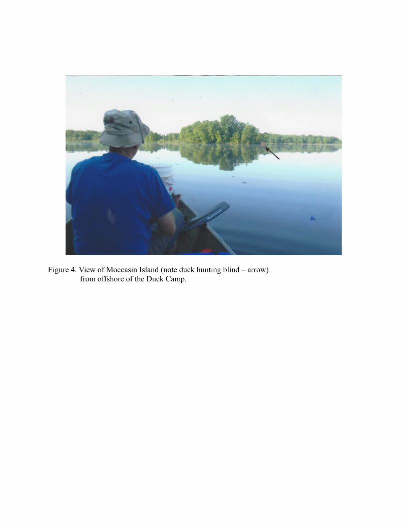
Figure 4. View of Moccasin Island (note duck hunting blind – arrow) from offshore of the Duck Camp.
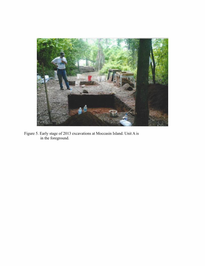
Figure 5. Early stage of 2013 excavations at Moccasin Island. Unit A is in the foreground.
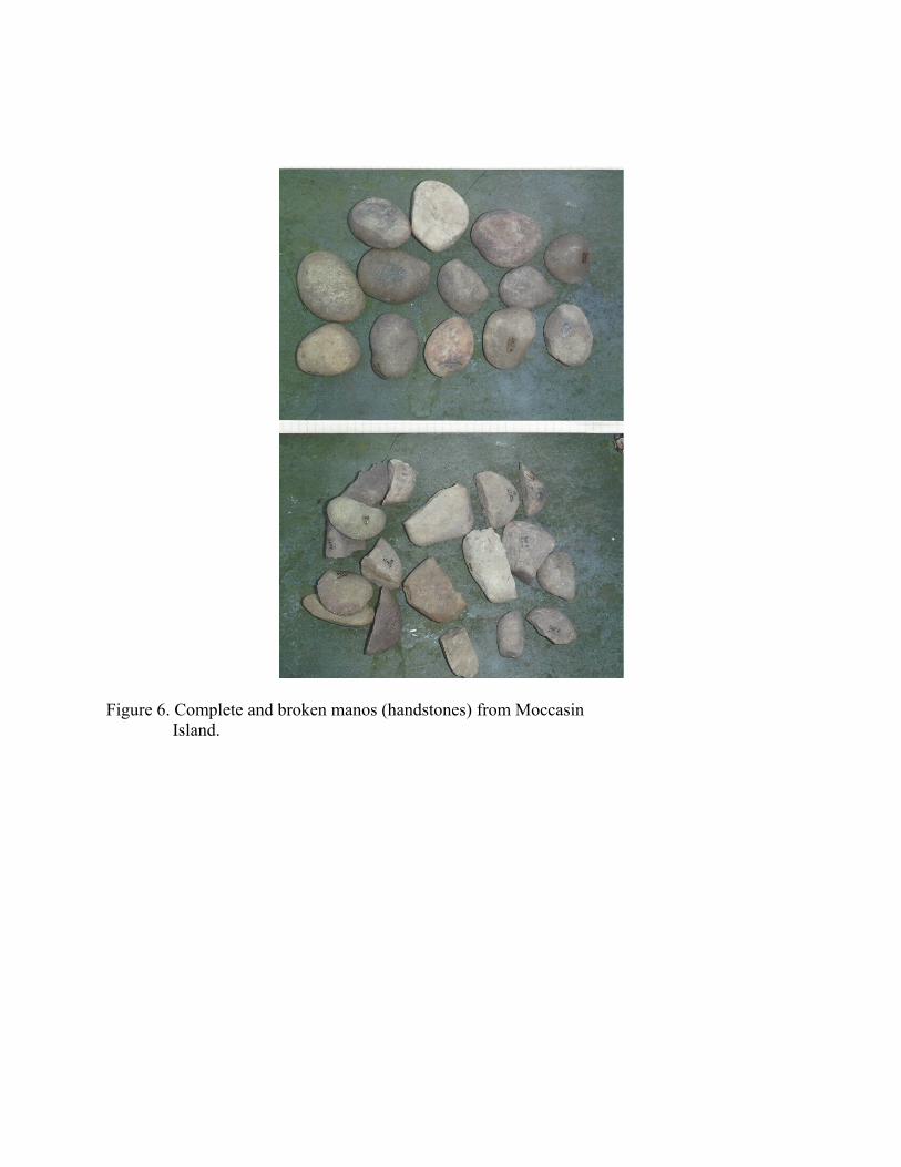
Figure 6. Complete and broken manos (handstones) from Moccasin Island.

Figure 7. Lapstones from Moccasin Island.

Figure 8. Pitted stones from Moccasin Island.

Figure 9. Discoids from Moccasin Island.
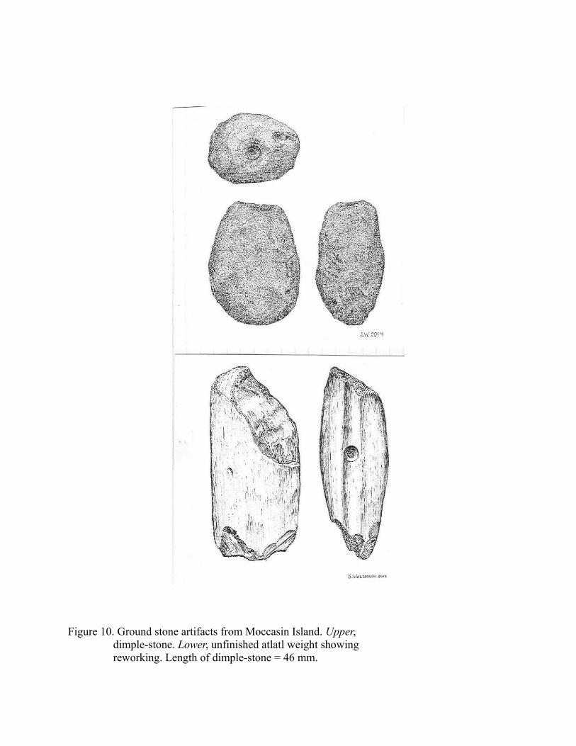
Figure 10. Ground stone artifacts from Moccasin Island. Upper, dimple-stone. Lower, unfinished atlatl weight showing reworking. Length of dimple-stone = 46 mm.

Figure 11. Projectile points from 2012-2015 excavations upon Moccasin Island: A, fragmentary Quad; B, Dalton; C, Rice-lobed; D, E – Archaic side-notched; F, Lost Lake; G, untyped Archaic corner-notched; H, I – Kirk. Length of D = 66 mm.

Figure 12. Additional projectile points from Moccasin Island: A, Lerma; B, Eva; C, D – Morrow Mountain; E, Cypress Creek (perhaps Figure 11G, as well). Length of A = 94 mm.
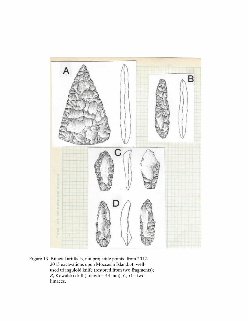
Figure 13. Bifacial artifacts, not projectile points, from 2012- 2015 excavations upon Moccasin Island: A, well- used trianguloid knife (restored from two fragments); B, Kowalski drill (Length = 43 mm); C, D – two limaces.
