a40 corridor a40 witney to oxford corridor...47072602: oxfordshire county council a40 corridor study...
TRANSCRIPT
A40 Corridor Review
March 2015
47072602
Prepared for: Oxfordshire County Council
A40 Witney to Oxford Corridor Study
Engineering Feasibility Study
Prepared by:
URS Infrastructure and Environment Limited
UNITED KINGDOM & IRELAND

47072602: Oxfordshire County Council
A40 Corridor Study -Engineering Feasibility
bdrp0002 a40 corridor review_final 3 March 2015
1
REVISION SCHEDULE
Rev Date Details Prepared by Reviewed by Approved by
1.0 10/02/15 FINAL DRAFT for review Mark Anslow
Associate
Jon Forni Technical Director
Jon Forni Technical Director
2.0 18/02/15 FINAL Draft response to R. O’Neil comments
Mark Anslow Associate
Jon Forni Technical Director
Jon Forni Technical Director
3.0 03/03/15 FINAL Mark Anslow Associate
Jon Forni Technical Director
Jon Forni Technical Director
47072602: Oxfordshire County Council
A40 Corridor Study -Engineering Feasibility
bdrp0002 a40 corridor review_final 3 March 2015
2
Limitations
URS Infrastructure & Environment UK Limited (“URS”) has prepared this Report for the sole use of Oxfordshire County Council (“Client”) in accordance with the Agreement under which our services were performed dated. No other warranty, expressed or implied, is made as to the professional advice included in this Report or any other services provided by URS. This Report is confidential and may not be disclosed by the Client nor relied upon by any other party without the prior and express written agreement of URS.
The conclusions and recommendations contained in this Report are based upon information provided by others and upon the assumption that all relevant information has been provided by those parties from whom it has been requested and that such information is accurate. Information obtained by URS has not been independently verified by URS, unless otherwise stated in the Report.
The methodology adopted and the sources of information used by URS in providing its services are outlined in this Report. The work described in this Report was undertaken between [insert date] and [insert date] and is based on the conditions encountered and the information available during the said period of time. The scope of this Report and the services are accordingly factually limited by these circumstances.
Where assessments of works or costs identified in this Report are made, such assessments are based upon the information available at the time and where appropriate are subject to further investigations or information which may become available.
URS disclaim any undertaking or obligation to advise any person of any change in any matter affecting the Report, which may come or be brought to URS’ attention after the date of the Report.
Certain statements made in the Report that are not historical facts may constitute estimates, projections or other forward-looking statements and even though they are based on reasonable assumptions as of the date of the Report, such forward-looking statements by their nature involve risks and uncertainties that could cause actual results to differ materially from the results predicted. URS specifically does not guarantee or warrant any estimate or projections contained in this Report.
Where field investigations are carried out, these have been restricted to a level of detail required to meet the stated objectives of the services. The results of any measurements taken may vary spatially or with time and further confirmatory measurements should be made after any significant delay in issuing this Report.
Copyright
© This Report is the copyright of URS Infrastructure & Environment UK Limited. Any unauthorised reproduction or usage by any person other than the addressee is strictly prohibited.

47072602: Oxfordshire County Council
A40 Corridor Study -Engineering Feasibility
bdrp0002 a40 corridor review_final 3 March 2015
3
47072602: Oxfordshire County Council
A40 Corridor Study -Engineering Feasibility
bdrp0002 a40 corridor review_final 3 March 2015
4
TABLE OF CONTENTS 1 INTRODUCTION ............................................................... 7
1.1 Background ...................................................................... 7
1.2 Scope of Assessment...................................................... 8
1.3 Layout of Report .............................................................. 8
2 STUDY AREA .................................................................... 9
2.1 Introduction ...................................................................... 9
2.2 Route Context .................................................................. 9
3 A40 HIGHWAY ASSESSMENT ...................................... 11
3.1 Introduction .................................................................... 11
3.2 Network Performance .................................................... 11
3.3 A40 Highway Cross Section Assessment ................... 14
3.4 Cross Section - Highway Verge .................................... 15
3.5 Cross Section - Pedestrian and Cycle Routes ............ 15
3.6 Cross Section - Bus Lanes ........................................... 15
3.7 Cross Section - Guided Busway .................................. 15
3.8 Constraints Mapping ..................................................... 16
3.9 Option Development ...................................................... 17
3.10 Focus for A40 Strategic Option .................................... 18
3.11 Corridor Constraints...................................................... 19
3.12 Bus Lane Termination ................................................... 20
3.13 Magnitude of Cost .......................................................... 21
4 SWINFORD TOLL BRIDGE ............................................ 23
4.1 Options Considered ....................................................... 23
4.2 Treatment for Swinford Toll Bridge ............................. 27
5 REUSE OF WITNEY AND CARTERTON RAILWAY ROUTE ............................................................................ 28
5.1 Introduction .................................................................... 28
5.2 A40 Witney – Oxford Corridor Route Strategy Baseline Statement ........................................................................ 28
5.3 Oxford – Witney – Fairford Railway ............................. 28
5.4 Disused Railway Route ................................................. 28
6 OUTLINE PRE-FEASIBILITY STUDY (2001) REVIEW . 30
6.1 Pre-Feasibility Study Remit .......................................... 30
6.2 Key Assumptions of 2001 Study .................................. 30
6.3 Transport System Options Considered ....................... 30
6.4 Condition of the Railway Route .................................... 31
47072602: Oxfordshire County Council
A40 Corridor Study -Engineering Feasibility
bdrp0002 a40 corridor review_final 3 March 2015
5
6.5 Validity of 2001 Study Findings .................................... 31
6.6 Option Evaluation .......................................................... 32
6.7 Cost Evaluation .............................................................. 33
6.8 Evaluation Tables .......................................................... 33
6.9 Conclusions from 2001 Study ...................................... 34
6.10 Concluding remarks - System Options ....................... 35
7 NATIONAL RAIL SYSTEM ............................................. 36
7.1 Network Rail System Development Strategy .............. 36
7.2 Network Rail Aspirations .............................................. 36
7.3 Train Operating Company (TOC) Aspirations ............. 39
7.4 Oxfordshire County Council Aspirations .................... 40
8 NON-CONVENTIONAL TRANSPORT SYSTEMS ......... 41
8.2 Tram / Train, ................................................................... 41
8.3 Tram ................................................................................ 42
8.4 People Movers ................................................................ 43
9 DISUSED RAILWAY LINE OPTIONS ............................. 45
9.1 Short Term Solutions .................................................... 45
9.2 Longer Term Solutions.................................................. 45
9.3 Order of Magnitude Costs ............................................. 50
9.4 Recent Rail Reinstatement Projects ............................ 51
9.5 Oxford Witney Route ‘Heavy’ Rail Option ................... 52
9.6 Light Rail Option ............................................................ 52
9.7 Guided Busway .............................................................. 54
10 CONCLUSIONS .............................................................. 55
10.2 A40 Highway Options .................................................... 55
10.3 Swinford Bridge ............................................................. 57
10.4 Focus of the Rail Industry ............................................. 57
10.5 Alternative Options ........................................................ 57
10.6 Recommendations/ Opinions related to promotion of Rail................................................................................... 59
47072602: Oxfordshire County Council
A40 Corridor Study -Engineering Feasibility
bdrp0002 a40 corridor review_final 3 March 2015
6
APPENDICES APPENDIX A: CROSS SECTIONAL ELEMENTS
APPENDIX B: HIGHWAY CONSTRAINTS MAPPING OUTPUT
APPENDIX C: SCHEMATIC CONCEPT SCHEME DRAWINGS

47072602: Oxfordshire County Council
A40 Corridor Study -Engineering Feasibility
bdrp0002 a40 corridor review_final 3 March 2015
7
1 INTRODUCTION
1.1 Background
1.1.1 URS (URS Infrastructure and Environment Ltd) has been appointed by Oxfordshire County Council (OCC) to provide MHA PSP1 call-off support to carry out initial feasibility and design work for a range of options to improve transport conditions along the A40 corridor between Witney and Oxford.
1.1.2 The A40 is a single carriageway Primary Route and the main route west from Oxford to Cheltenham, Gloucester and south Wales. It is the main connection between Oxford and the growing settlements of Witney and Carterton, carrying a daily flow of between 23,000 and 30,000 vehicles; well above the road’s link capacity. Junction capacity issues at Eynsham/ Cassington and Wolvercote/ Cutteslowe aggravate this issue. The result is overall route congestion and poor journey times. The levels of congestion impact on bus services with the A40 used, in whole or in part, by most of the bus services running between Carterton/ Witney and Oxford. Currently the only rail connection between the settlements is by joining the Oxford-Worcester trains at Hanborough, which is of limited attractiveness.
1.1.3 In response to these issues OCC has prepared a Baseline Statement that sets out current and forecast future demands on the route. The Statement identifies a number of possible strategies that could be adopted to address the A40 situation, either singly or in combination, to provide a long-term solution. These include the options identified in Figure 1.1:
Figure 1.1: Baseline Statement Options for Consideration
Main Option
1. Bus lane (includes new bus routes)
2. Guided busway along line of old rail line
3. Heavy rail re-opening, predominantly on old line, new route south of Witney Bypass
4. Tram/ train operation mostly on separate track, on-street operation Witney
5. Dual carriageway (Witney/ Eynsham/ Wolvercote)
6. Tidal Flow Lane (Cassington – Wolvercote)
7. Inbound traffic lane (Cassington – Wolvercote) + Outbound traffic lane (Eynsham – Witney)
1.1.4 The statement also identifies that OCC already has a number of schemes proposed that could bring some relief to the A40, which include:
• Improvements identified for Wolvercote and Cutteslowe roundabouts;
• The development of proposals in line with developments at the Oxford Northern Gateway Development that may include improvements to Peartree Interchange, new access routes and a Link Road between the A40 and A44.
1.1.5 These proposals are however unlikely to resolve the current capacity issues on the A40 or more critically deal with the impact of future developments in West Oxfordshire.

47072602: Oxfordshire County Council
A40 Corridor Study -Engineering Feasibility
bdrp0002 a40 corridor review_final 3 March 2015
8
1.2 Scope of Assessment
1.2.1 The scope of the commission is two-fold:
• To identify a scheme that can be delivered within the timescale and financial limitations imposed by the Local Government Finance Settlement (LGFS) provisional award (2017/18); and
• Identify options for potential long-term schemes that could build upon the LGFS funded scheme with a delivery timescale to 2031.
1.2.2 The assessment is fundamentally a desk-top study, based upon existing data sources and minimal additional data collection. The output from the study will provide the background information and material for a public consultation and exhibition on both the LGF scheme and long term strategy that is scheduled to take place in June/July 2015.
1.2.3 The study focuses on delivery of an LGFS scheme that can be promoted as either a first phase of one or more of the longer term strategy options or be a scheme that is readily convertible into one or more of these options; for instance by providing space that could be used in the short term as a bus lane with the potential for future conversion e.g. into a tram line or general traffic lane. The objective is to ensure that any proposed LGFS scheme does not predetermine the choice of long term scheme or rule out any of the longer term strategy options. The scope of assessment also includes consideration of the possibilities of providing:
• A Park & Ride facility along the A40, either at Eynsham or Witney; and
• The provision of bus priority on the approaches to Swinford Toll Bridge
1.2.4 For the longer term the assessment considers whether, and if so how, schemes need to be extended to the east of Wolvercote. Overall the study concentrates on three main topic headings:
• A40 Road Solutions - bus lanes/ guided bus, dual carriageway, tidal flow etc.
• Rail Solutions - Heavy Rail and possibly Tram or use of old rail line for guided bus; and
• Other supporting infrastructure or alternatives - P&R, LRT, PRT etc.
1.3 Layout of Report
1.3.1 To follow this introduction:
• Chapter 2 confirms the study area with a short outline of the route context, followed by Chapter 3 that provides background to the Highway Assessment of the A40 corridor to include dialogue on the constraints mapping exercise carried out and the findings from the assessment;
• Chapter 4 examines the potential to deliver improvements to ease the passage of buses through Swinford Bridge;
• Chapter 5 offers background related to the reuse of the Witney and Carterton to Oxford railway route followed by Chapter 6 that provides an update and reappraisal on the previous findings of a 2001 pre-feasibility report related to the matter;
• Chapter 7 outlines the potential future development of the Rail system in the area through a summary of the potential plans and aspirations by National Rail and the Train Operating Companies for rail travel in the area, to include a view on reopening the line;
• Chapter 8 examines non-conventional transport systems in the form of Train/ Tram, Trams and People Movers to set the context for their use as a potential alternative to heavy rail along the disused railway line. This is followed by Chapter 9 that examines options for re-opening the line in both the short and long term to include considerations related to its use by heavy rail, light rail/ tram and as a route for guided buses.
• Finally, Chapter 10 provides conclusions with some recommendations and opinions.
47072602: Oxfordshire County Council
A40 Corridor Study -Engineering Feasibility
bdrp0002 a40 corridor review_final 3 March 2015
9
2 STUDY AREA
2.1 Introduction
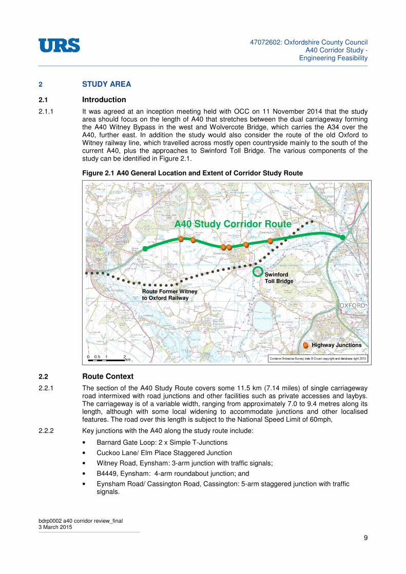
2.1.1 It was agreed at an inception meeting held with OCC on 11 November 2014 that the study area should focus on the length of A40 that stretches between the dual carriageway forming the A40 Witney Bypass in the west and Wolvercote Bridge, which carries the A34 over the A40, further east. In addition the study would also consider the route of the old Oxford to Witney railway line, which travelled across mostly open countryside mainly to the south of the current A40, plus the approaches to Swinford Toll Bridge. The various components of the study can be identified in Figure 2.1.
Figure 2.1 A40 General Location and Extent of Corridor Study Route
2.2 Route Context
2.2.1 The section of the A40 Study Route covers some 11.5 km (7.14 miles) of single carriageway road intermixed with road junctions and other facilities such as private accesses and laybys. The carriageway is of a variable width, ranging from approximately 7.0 to 9.4 metres along its length, although with some local widening to accommodate junctions and other localised features. The road over this length is subject to the National Speed Limit of 60mph,
2.2.2 Key junctions with the A40 along the study route include:
• Barnard Gate Loop: 2 x Simple T-Junctions
• Cuckoo Lane/ Elm Place Staggered Junction
• Witney Road, Eynsham: 3-arm junction with traffic signals;
• B4449, Eynsham: 4-arm roundabout junction; and
• Eynsham Road/ Cassington Road, Cassington: 5-arm staggered junction with traffic signals.
Swinford Toll Bridge
A40 Study Corridor Route
Route Former Witney to Oxford Railway
Highway Junctions

47072602: Oxfordshire County Council
A40 Corridor Study -Engineering Feasibility
bdrp0002 a40 corridor review_final 3 March 2015
10
2.2.3 The A40 between Witney and Eynsham is a critical part of the route supporting bus route S1 and S2. While the route of the S2 continues along the A40 to link with Wolvercote roundabout and then with Central Oxford, the S1 leaves the road at Eynsham to follow Witney Road, via Swinford Toll Bridge, for access to the City Centre.
47072602: Oxfordshire County Council
A40 Corridor Study -Engineering Feasibility
bdrp0002 a40 corridor review_final 3 March 2015
11
3 A40 HIGHWAY ASSESSMENT
3.1 Introduction
3.1.1 The baseline conditions that are currently experienced along the A40 corridor have been informed by reference to a Baseline Statement
1 provided by OCC, which presents a
comprehensive review of prevailing transport conditions. Chapter 2 of this Draft contains useful data and commentary on the operational characteristics of the route, to include data and interpretation on matters such as traffic flow and composition, network performance, travel behaviours, bus patronage and accident analysis.
3.1.2 In terms of traffic demand the key findings from this Draft report based on traffic data collected east of Cassington during March 2014 were:
• Cars and Light Vans form some 75 percent of the daytime traffic flow;
• Goods vehicles make up the remainder, with buses forming only one per cent;
• There is very little seasonal variation in traffic flows along the route - All monthly five-day averages for 2013 were between 23,000 and 25,000 vehicles, with December (Holiday Season) and January (Prolonged Snow) slightly lower;
• Weekday flows in the eastbound direction range between 11,500 to just over 12,000 vehicles per day, with Saturdays some 10 to 15 percent lower and Sundays approaching Weekday levels. A similar profile was observed for westbound traffic;
• Dominant inbound (eastbound) flow towards Oxford with a distinct peak (07:00 - 08:00hrs) at over 1,000 vehicles - secondary peak (10:00 - 11:00hrs) at some 850 vehicles per hour;
• Westbound flows displays a relatively small morning peak (08:00-09:00hrs) gradually building to a peak commencing at 16:00hrs of 900 vehicles per hour - secondary peak commencing 19:00hrs at 750 vehicles per hour.
• Combined two-way flows relatively stable at between 1,400 and 1,700 vehicles per hour. 07:00 - 18:00hrs.
3.2 Network Performance
3.2.1 The OCC Baseline report also provided an assessment of link performance through application of guidance provided by Department for Transport Advice Note TA46/ 97
2. A40 flows were compared
with design thresholds provided by Table 2.1 within the Advice Note; this is reproduced for reference in this feasibility report as Table 3.1.
3.2.2 The exercise suggested that the current flows exceed those that would normally be expected for a WS2- Wide Single Carriageway road (i.e. a road with a nominal width of 10.0m) and well above that indicated for a two lane S2 - Single Carriageway, which is a characteristic of the A40 study route.
1 A40 Witney - Oxford Corridor Route Strategy: Baseline Statement. September 2014. Oxfordshire County Council
2 TA 46/ 97 Traffic Flow Ranges for use in the Assessment of New Rural Roads. DMRB 5.1.3. Department for Transport
Table 3.1: Opening Year Economic Flow Ranges
Carriageway Standard
Opening Year Annual Average Daily Traffic (AADT)
Minimum Maximum
S2 Up to 13,000
WS2 6,000 21,000
D2AP 11,000 39,000
D3AP 23,000 54,000
D2M Up to 41,000
D3M 25,000 67,000
D4M 52,000 90,000
Reproduced from Table 2.1 TA46/ 97.

47072602: Oxfordshire County Council
A40 Corridor Study -Engineering Feasibility
bdrp0002 a40 corridor review_final 3 March 2015
12
3.2.3 TA46/ 97 was also used to guide the Baseline Report on the capabilities of the A40 in terms of A40 capacity through an assessment to determine the Congestion Reference Flow (CRF). The CRF evaluation provided evidence on the degree to which existing traffic demand exceeded the maximum sustainable throughput of the link. The output of this exercise indicated that:
• The section to the west of Eynsham was already well above its link capacity, while;
• Flow to the east was just above capacity.
3.2.4 The findings verified observations of flow breakdown for westbound traffic in the evening peak to the west of Barnard Gate, while it was also noted that ‘the impact of the limited capacity on the approaches to Oxford are masked by even greater capacity issues in North Oxford’.
3.2.5 Further empirical evidence on the impact of congestion was also provided in the form of journey time analysis to cover average eastbound journey times during 2013 while travelling the 4.1km between Cassington Traffic Lights and the A34 flyover. The output was presented in the form of a graph, which is reproduced for ease of reference as Figure 3.1
Figure 3.1: A40 2013 Average Weekday Journey Time Graph
Source: Figure 10. A40 Witney - Oxford Corridor Route Strategy: Baseline Statement. September 2014. Oxfordshire County Council
3.2.6 The record of journey times revealed distinct average journey time characteristics across a 24hour period. Distinct peaks and troughs can be identified from the journey time data and Table 3.2 provides an indication of average vehicle speeds associated with them.

47072602: Oxfordshire County Council
A40 Corridor Study -Engineering Feasibility
bdrp0002 a40 corridor review_final 3 March 2015
13
Table 3.2: OCC Congestion Monitoring 2013 - Key Features Average Daily Speed Profile
Period Notes Time Speed
kph mph
19:00 - 06:00 Free Flow Off-Peak Conditions ≐3 mins 93 58
08:00 - 09:00 Including School Holidays ≐8 mins 31 19
Excluding School Holidays +9 mins 27 17
09:00 - 16:00 Day Time Inter-Peak ≈5 mins 49 30
17:00 Evening Peak - falling to inter peak time +6 mins 41 25
Key to Symbols: ≐ Approaching ≈ Around + Over
3.2.7 The figures confirm a significant variation in travel speed when the free flow off peak speed of 93kph (58mph) is compared with the lowest value for the period 08:00 to 09:00 hours at 27kph (17mph); a difference of 66kph (41mph).
3.2.8 The Baseline statement acknowledges that the analysis of 2013 journey time data are average figures that could mask a degree of variability that is experienced by regular users of the route, pointing to 2004 surveys that indicated that during peak periods the worst days could have a journey time up to 50 per cent higher than the average; suggesting a journey speed as low as 16kph (10mph) could be experienced on occasions.
3.2.9 A visual interpretation of these circumstances is presented by Google Earth Maps, where a representation of typical traffic conditions is presented based on collated journey time data. A characteristic output is shown in Figure 3.2 for a Monday Morning during the peak hour.
Figure 3.2: Google Earth Image - A40 Typical Traffic Conditions, East of Eynsham
< 11mph
< 12 - 20mph
< 21 - 40mph
> 41mph
Key
A40 - Typical Traffic Speeds Snap-Shot Monday AM Peak Source: Google Earth Image - Accessed 2 March 2015
47072602: Oxfordshire County Council
A40 Corridor Study -Engineering Feasibility
bdrp0002 a40 corridor review_final 3 March 2015
14
3.2.10 Overall the evidence confirms that congestion and associated queuing is a regular feature of the route across a significant part of the day and in particular during the morning and evening peak hours. Not only is this likely to prove frustrating for general through and more local commuter traffic, it is also highly disruptive to local public transport services seeking to maintain a regular schedule for journeys to and from the City.
3.2.11 The OCC Baseline Statement provides firm evidence to support the relatively long-standing aspirations for revisions and a sustainable alternative route strategy for the A40.
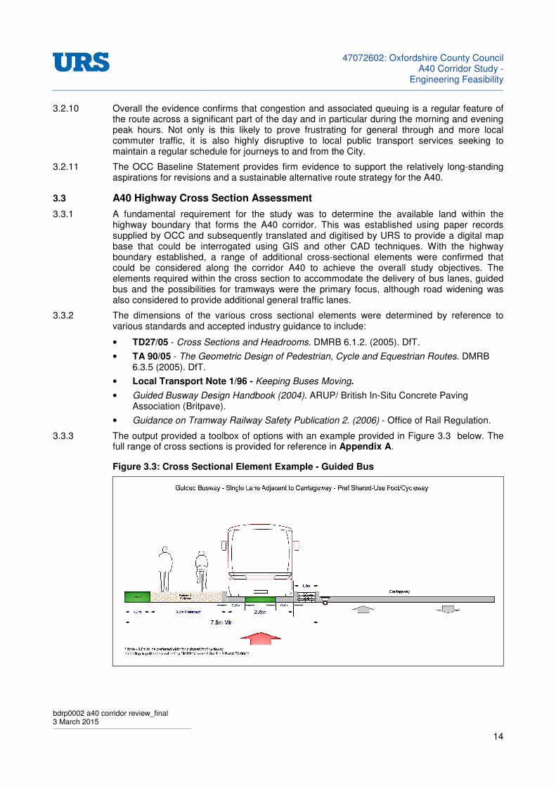
3.3 A40 Highway Cross Section Assessment
3.3.1 A fundamental requirement for the study was to determine the available land within the highway boundary that forms the A40 corridor. This was established using paper records supplied by OCC and subsequently translated and digitised by URS to provide a digital map base that could be interrogated using GIS and other CAD techniques. With the highway boundary established, a range of additional cross-sectional elements were confirmed that could be considered along the corridor A40 to achieve the overall study objectives. The elements required within the cross section to accommodate the delivery of bus lanes, guided bus and the possibilities for tramways were the primary focus, although road widening was also considered to provide additional general traffic lanes.
3.3.2 The dimensions of the various cross sectional elements were determined by reference to various standards and accepted industry guidance to include:
• TD27/05 - Cross Sections and Headrooms. DMRB 6.1.2. (2005). DfT.
• TA 90/05 - The Geometric Design of Pedestrian, Cycle and Equestrian Routes. DMRB 6.3.5 (2005). DfT.
• Local Transport Note 1/96 - Keeping Buses Moving.
• Guided Busway Design Handbook (2004). ARUP/ British In-Situ Concrete Paving Association (Britpave).
• Guidance on Tramway Railway Safety Publication 2. (2006) - Office of Rail Regulation.
3.3.3 The output provided a toolbox of options with an example provided in Figure 3.3 below. The full range of cross sections is provided for reference in Appendix A.
Figure 3.3: Cross Sectional Element Example - Guided Bus

47072602: Oxfordshire County Council
A40 Corridor Study -Engineering Feasibility
bdrp0002 a40 corridor review_final 3 March 2015
15
3.4 Cross Section - Highway Verge
3.4.1 The highway verge is regarded as any nominally flat area between the edge of the paved carriageway and either the start of an adjacent side slope or where one is not present, the highway boundary or bridge parapet. In accordance with TD27/ 05 the minimum width of verge is 1.5m however, where footways and/ or cycleways are likely to be incorporated into the verge, a minimum width of 3.0 metres is preferable.
3.5 Cross Section - Pedestrian and Cycle Routes
3.5.1 TA90/05 recommends a preferred width for Pedestrian-Only routes at 2.6 metres with 2.0 metres acknowledged as an acceptable minimum. The Advice Note also recommends a preferred width for off-carriageway cycle-only routes of 3.0 metres, although 2.0 metres is also advised as an acceptable minimum. In situations where it is not practicable to provide widths of 2.0 metres for cyclists along the full length of the route, widths of 1.5 metres are considered acceptable over short distances.
3.5.2 Guidance related to shared-use for pedestrians and cyclists is also provided, with the suggestion that this should generally be restricted to situations where flows of either cyclists or pedestrians are low. The recommended preferred minimum width for an unsegregated facility is 3.0 metres although 2.0 metres is acknowledged as satisfactory where the combined pedestrian and cycle use is less than 200 per hour.
3.5.3 Where a footway, cycleway or shared use facility is provided within the verge, a further minimum width of 1.0 metres is advised along the non-traffic flank of any footway/ cycleway and either the start of an adjacent side slope or one is not present, the highway boundary or bridge parapet. Nominally the addition of this relatively flat area would be available to accommodate features such as lighting columns or other highway or utility equipment. When combined with a footway, cycleway or shared use facility.
3.6 Cross Section - Bus Lanes
3.6.1 LTN 1/96 suggest that where roads are wide enough a bus lane should be 4.25metres wide, with the minimum preferred width recommended at 4.0m; this would allow buses to overtake cyclists safely and reduces the likelihood of interference from general traffic in the adjacent lane. The minimum recommended width is 3.0 metres.
3.6.2 Contraflow bus lanes should be at least 3.0 metres wide and separated from the rest of the carriageway either by a solid white line of an appropriate form of physical separation. In common with a ‘with-flow’ bus lane, the recommended width where cyclists are allowed to use the lane is 4.25 metres with a preferred minimum of 4.0 metres.
3.6.3 In common with road widening to accommodate additional traffic lanes, drainage will be a consideration where an additional lane is considered along either flank of the A40. The existing drainage gullies and associated connections will need to be relocated to the outside edge of any new construction. This is required to maintain the cross-fall from the centre of the road and to remove drainage gullies from the running surface; while also removing the risk of surface water retention between any old and new parallel sections of carriageway.
3.7 Cross Section - Guided Busway
3.7.1 A typical width for two lanes of kerbed guided busway is 6.7 metres, made up of two, 2.6 metre wide bus lanes, 0.8 metres central reservation and 1.0 metres evacuation strip. While the cross section for a two lane guided bus way indicates a minimum width of 0.5 metres as verge in addition to the evacuation strip, an increase to provide a minimum of 1.0 or, where preferably, 2.0 metres is considered more suitable for the reasons given in 3.5.2.
47072602: Oxfordshire County Council
A40 Corridor Study -Engineering Feasibility
bdrp0002 a40 corridor review_final 3 March 2015
16
3.7.2 In the absence of a carriageway running alongside a guided busway consideration should also be given to the provision of an appropriate maintenance track alongside the guided busway, especially in rural areas where space is available, to accommodate service vehicles and alike. Provision will be necessary to allow independent access to the bus way by non-guided vehicles to allow for activities such as servicing the route and to assist in the event of vehicle breakdowns. This would add an additional feature to the cross section, with an extra width of 4.0 metres the recommended minimum. The maintenance track could also provide a vital route for emergency service vehicles should an incident occur along the busway.
3.7.3 Consideration of the emergency evacuation route to cater for passengers leaving the bus in an emergency is another matter for consideration at detailed design. It will be necessary to offer a clear unobstructed path to allow passengers to leave the scene as quickly as practicable.
3.8 Constraints Mapping
3.8.1 The various cross sectional elements were applied along the route as part of a constraints mapping exercise to establish issues and potential risks that could impact on delivery of any applied cross section or supporting infrastructure. This involved consideration of the geometric and engineering requirements for a revised road layout to include but not limited to matters such as:
• The extent of the highway boundary;
• Issues associated with potential land take;
• Adjoining land uses;
• Topography; and
• The presence and potential interaction with junctions.
3.8.2 As a starting point GIS software was used to trace four offset lines that would be equivalent to a range of representative cross-sectional features identified in Table 3.3:
Table 3.3: Feature Offset Dimensions
3.8.3 While the offsets do not cover the entire range of possibilities, it was considered that 7.25 metres was likely to be the widest dimension that could reasonably be accommodated alongside the existing A40 carriageway without straying beyond the highway boundary.
3.8.4 With the GIS mapping exercise complete, a detailed assessment was carried out along the route at 10 metre intervals to identify locations where these representative offsets would breach the highway boundary, or alternatively impact on some adjacent structure or feature with an associated risk in terms of the prospect for delivery at justifiable time and cost.
3.8.5 The output from this exercise was in the form of an Excel Spreadsheet, with an extract shown in Figure 3.4 and the complete routes provided as a series in Appendix B.
PERIOD OFFSET (Metres)
Minimum Width On-Carriageway Bus Lane - Minimum Width Shared Use 6.00
Minimum Width Single Lane Guided Busway - Minimum Width Shared Use 6.60
Minimum Width On-Carriageway Bus Lane - Preferred Width Shared Use 7.00
On-Carriageway Bus Lane Shared with Cycles - Minimum Width Footway 7.25

47072602: Oxfordshire County Council
A40 Corridor Study -Engineering Feasibility
bdrp0002 a40 corridor review_final 3 March 2015
17
Figure 3.4: Example Output - A40 Constraints Mapping Exercise.
3.9 Option Development
3.9.1 The constraints mapping exercise identified a number of sections where the provision of even the minimum width guided busway, bus lane or additional traffic lane was likely to transgress the existing public highway boundary or require revisions to it. In a number of situations, while the proposed lanes could fit within the boundary, the presence of structures spanning roads or water courses would require a set back or revision that could demand additional land to supporting the construction; for example regarding of embankment, relocation of retaining structures, to accept the widening.
3.9.2 In the absence of acquiring additional highway land, this would subsequently impact on the overall route continuity if an uninterrupted facility is the desirable optimum.
3.9.3 The baseline position for both road and potential re-use of the former Oxford to Witney rail line were discussed at a meeting with Officers of OCC in Oxford on Friday 16 January 2015. The various constraints along the route were examined and discussed in detail.
3.9.4 It was agreed that the option for a guided busway faced too many obstacles in terms of passing across junctions, accesses and various structures along the route to make the option attractive at this time. It was however agreed that there would be considerable merit to be gained through the promotion of the alternative for widening to provide a parallel bus lane along the route where practicable. For this purpose it was agreed that that the strategy would be to develop the bus lane option between the A40/ B4449 roundabout at Eynsham and the area in the vicinity of the section where the A40 passes over Kingsbridge Brook; some 0.65km (0.4 miles) west of the A34 Wolvercote Bridge as this was the most congested section. This would concentrate the study into a route covering some 5.5km (3.36 miles) long.
Witney
Oxford
A40
High Risk Impact on Highway Boundary or other feature.
Medium risk Impact on Highway Boundary or other feature.
Low Risk impact on Highway Boundary or other feature.

47072602: Oxfordshire County Council
A40 Corridor Study -Engineering Feasibility
bdrp0002 a40 corridor review_final 3 March 2015
18
3.9.5 It was also agreed that to revise the various structures in the vicinity of Kingsbridge Brook and further east to the A34 to accommodate a proposed bus lane would present an unacceptable cost and engineering challenge that could not be justified at this time.
3.9.6 It was also recognised that the proposed improvements associated with Wolvercote roundabout would also provide desirable improvements east of the A34 Wolvercote Bridge.
3.10 Focus for A40 Strategic Option
3.10.1 The outcome of the meeting witnessed agreement that parallel widening to deliver a 4.0 metre bus lane would provide the most feasible solution in the circumstances in terms of delivering a cohesive and coherent public transport facility along the A40 corridor. The provision of such a facility would not inhibit future consideration of reallocating the road space at a later date to accommodate less exclusive uses; i.e. the potential for conversion to a High Occupancy Vehicle (HOV) or supplementary general traffic lane if warranted.
3.10.2 Selective priority measures for public transport along the A40 can improve the overall efficiency of the network, generating improvements in terms of reliability, reductions in delays and improvements in journey times. Improving bus service quality by reducing journey times and improving reliability will be a key factor in encouraging modal shift from cars to public transport; with the objective of releasing capacity along the A40 corridor. With the infrastructure in place there are opportunities to build on the concept and consider further extension and coordination with other facilities, such as a Park and Ride, where demand can be justified.
3.10.3 It was accepted that the provision of a bus lane would need to be accompanied by an engineering solution at suitable locations to allow the bus to re-join the main carriageway where physical constraints formed generally by structures, create pinch-points that would impede a continuous route strategy; the alternative would be to promote mitigation through widening of structures, which is also likely to need a revision to the highway boundary.
3.10.4 In view of concerns that relatively higher speed buses could be travelling on the bus lane alongside slow moving or even stationary vehicles on the A40 in the remaining general traffic lanes, it was also agreed that the bus lane would offer a 3.0 metre running lane that would be separated from adjacent traffic by a metre of white hatched road markings to Diagram 1041.1. The white hatching would provide a buffer zone between the lanes. Fundamentally this is an adaptation of the cross section example for a 4.0m bus lane provided in Appendix A.
Figure 3.5: Nominated Bus Lane Cross Section for Progression along A40 Corridor
47072602: Oxfordshire County Council
A40 Corridor Study -Engineering Feasibility
bdrp0002 a40 corridor review_final 3 March 2015
19
3.10.5 Notably carriageway widening to accommodate this extra 4.0 metre lane width would offer a degree of flexibility in the design of the A40 corridor as it could be used for less exclusive use in future should conditions dictate there is a need for enhanced flexibility in the allocation of road space
3.10.6 To accompany the bus lane it was also agreed that a 2.0 metre wide shared use footway/ cycleway would be reasonable for the circumstances, flanked on its side furthest from the carriageway edge, by a minimum 1.0 metre verge. It was acknowledged that the drainage system alongside the A40 would need revision to accommodate these proposals.
3.10.7 An additional width of 7.0 metres therefore represents the minimum overall widening required to accommodate these elements along one side of the existing A40 carriageway. Where circumstances allow it would be expected that any balance of available width would be absorbed by increasing the verge dimension at the back of the shared use footway/ cycleway above the proposed 1.0 metre minimum.
3.10.8 The various elements comprising the proposed 7.0 metre widening to accommodate a bus lane alongside the carriageway flanks were mapped along the agreed route section between the A40 using AutoCAD mapping and design software. The exercise reaffirmed the pinch-points identified during the initial GIS mapping exercise. A preliminary desk-top engineering assessment was made to determine those sections that would be suitable for delivery of the proposed bus lane and those that would not.
3.11 Corridor Constraints
3.11.1 The assessment has revealed three High and one Medium risk area of constraint along the A40 that would impact significantly on a continuous bus lane and potentially any other facility requiring the same or more width, for the length of the A40 between the A40/ B4449 junction at Eynsham and Wolvercote roundabout. For ease of reference these are broadly identified in Figure 3.6.
Figure 3.6: Proposed Bus Lane Extents and Significant Physical Constraint Issues
Proposed Eastbound Bus Lane Physical Constraint - High Risk
Proposed Westbound Bus Lane Physical Constraint - Medium Risk
Bridge structure spanning River Evenlode - South West of Cassington;
Staggered traffic signal controlled junction - Immediately South West of Cassington;
Bridge spanning route of former Witney - Oxford railway; and
Bridge spanning Kingsbridge Brook and other structures further east to A34.
47072602: Oxfordshire County Council
A40 Corridor Study -Engineering Feasibility
bdrp0002 a40 corridor review_final 3 March 2015
20
3.11.2 In principle it would be practicable to provide a bus lane between the A40/ B4449 4-arm roundabout junction at Eynsham in the west and the A34 overbridge to the east. There are however some obstacles along the route that would impact on risk and cost. These relate to the:
• Revisions to the traffic signal arrangement at the A40/ Eynsham Road/ Cassington Road staggered junction would also be necessary, although likely to be less onerous. The objective would be to provide a controlled route through the intersection such that buses are able to secure a reasonably uninterrupted passage through the junction. For eastbound travel the use of a suitably configured bus pre signals and subsequent coordination with a revised traffic signal arrangement is considered a practicable consideration. The circumstances for westbound travel are more complex given the presence of the access road serving Marlborough Pool, which lies opposite Eynsham Road, where the existing traffic signals would require relocation with further potential require an adjustment to the highway boundary to support any proposed features.
• Environs surrounding bridge structures spanning various features, notably to include the former rail line, where the physical width available between the edge of carriageway and either structural features or the highway boundary is insufficient to accommodate the required widening by some margin. In all these cases it would be necessary to promote widening of the structure to provide a continuous bus lane, which carries the risk of the need to acquire additional highway land and the cost of delivering the necessary structural alterations.
• Potential need to overlook the section at this time between Kingsbridge Brook and the A34 over-bridge, as the number of structural revisions required could be anticipated to be highly complex to negotiate and resolve, especially where the railway, adjacent canal and A34 structures are concerned.
3.11.3 There would also be a need to examine in more detail the specific requirements associated with crossing various access points and junctions although, in most cases, it is considered likely that there would be sufficient width available to deliver a suitable mitigation strategy to overcome these issues. Areas of particular note are:
• A40 Northern Flank - Culvert approximately 200 metres east of A40/ B4449 roundabout;
• A40 Southern Flank - Entrance and Exit to Roadside Services immediately east of A40/ B4449 roundabout;
• A40 Northern Flank: Left-in/ Left Out Junction and associated access junction of similar design some 100 metres further east along the southern flank of the A40, which both serve the current Anaerobic digestion facility and Hanson Quarry Land;
• A40 Southern Flank - layby facility around 300-350 metres east of the above;
3.12 Bus Lane Termination
3.12.1 While significant lengths of bus lane have been identified inevitably there will be a requirement for buses to rejoin the main carriageway. It is reasonable to suggest that most bus lanes are associated with routes passing through urban areas and as a consequence it is largely the case that this maneouvre is associated with traffic signal control; either at a main intersection or using Bus Advance Areas with a pre-signal in advance of the main junction that allows a bus to advance ahead of other traffic between the two sets of signal control.
3.12.2 Between the A40/ B4449 Roundabout and the A34 there is currently only one traffic signal installation, found to the south west of Cassington, which offers the opportunity for a relatively converntional bus pre-signal arrangement. With a pre-signal installed, buses would be presented with a controlled method to allow them to return to the main carriageway, allowing them to negotiate a relatively constrained section of carriageway before subsequently returning to a downstream section of bus lane.
47072602: Oxfordshire County Council
A40 Corridor Study -Engineering Feasibility
bdrp0002 a40 corridor review_final 3 March 2015
21
3.12.3 The assessment has identified other locaitons where other physical constraints associated with structures may require a termination of the bus lane for a cetain distance before resuming again further downstream unless structures can be extended.
3.12.4 For safety and other reasons it is considered unreasonbale that a bus would be able to simply merge with the main traffic flow and as a consequence a more formal method of controlled entry would seem necessary. In theory the use of a Bus Advance Area controlled by traffic signals is a possibility however, there is a legitmate concern that given the relatively rural nature of the A40, such use in what is likely to be reativly isolation locations that are reasonably detached from an associated traffic signal controlled junction, this could present a road safety hazard.
3.12.5 In general it is recommended that removing the pinch-point through widening of the relevant structure would offer the optimal solution. It is however recognised that this would have cost and possibly land ownership implications.
3.12.6 Although this is a avenue to be explored for the majority of the structures identifed, one significant ommission from this regime would involve the termination of the bus lane approaching the A34 overbridge. It has already been recognised that widening the various structures between Kingsbridge Brook and the A34 would be a relatively complex and onerous task to resolve, with significant implications in terms of both time and cost.
3.12.7 The one exception to this could be to mark the termination of the bus lane towards the eastern end of the A40 approaching the A34 overbridge. It is anticipated that drivers will be more willing to acknowledge and accept signal control approach the City fringes as it should be recognised as the beginnings of a more urban environment. It would however be necessary to promote a lower speed limit to facilitiate the installation of traffic signals and a reduction to at least 40mph in the vicinity of any proposed Bus Advance Area traffic signals would be a minium requirement.
3.12.8 Given the high level nature of this assessment, the proposals as discussed are at concept level at this stage. Significantly more scrutiny will be required to determine the engineering details attached to the scheme, especially where any proposed bus lane or shared used footway/ cycleway is required to cross junctions, private accesses and in the vicinity of structures such as over-bridges, embankment or culverts.
3.12.9 Ultimately any firm proposals would need to be subject to more detailed design and a full safety audit.
3.12.10 The strategic concepts associated with the overall route are presented in a series of drawings included as Appendix C.
3.13 Magnitude of Cost
3.13.1 It is estimated that when the cost of the shared use path, potential diversion of utility apparatus and design and supervision fees are taken into account, the basic provision of a bus lane is likely to cost in the region of around £1.5m per kilometre for one side of the road; parallel widening along both flanks would double this figure. The distance between the A40/ B4449 roundabout at Eynsham and
3.13.2 Delivery of a traffic signal controlled Bus Advance Area is also likely to cost in the region of £50k-60k per installation; although the presence of a suitable electricity supply in the area would have a bearing on cost in the event that significant cabling is required. Revisions to the traffic signal timings and potential relocation of traffic signal heads at Cassington would also incur a cost as part of an promoting a suitable design.
3.13.3 The potential revision to individual structures is likely to require consideration of two elements:
• The actual widening of the structure itself; and
• Any associated earthworks n the approaches to accommodate the widening, which in some cases would require regarding of embankments and/ or provision of retaining walls.
47072602: Oxfordshire County Council
A40 Corridor Study -Engineering Feasibility
bdrp0002 a40 corridor review_final 3 March 2015
22
3.13.4 In all cases it is anticipated that any widening at bridge structures or revisions to embankment would involve a cost to negotiate and secure a revision to the existing highway boundary.
3.13.5 As a guide price and example it is estimated that structural widening of the A40 bridge over the former Witney to Oxford railway line would cost somewhere in the region of £1.4m for widening along one side of the structure to include associated earthworks; with double this amount for widening the structure along both side. The cost of structural alterations is very much dependant on the scale, location and integrity of the structure itself and as a consequence a more accurate estimate can only be derived to follow a more detailed assessment.
3.13.6 Assuming a bus lane along both sides, revisions to the current traffic signals south east of Cassington, alterations to the equivalent of two bridge structures and the installation of two Bus Advance Areas controlled by traffic signals, a guide price to deliver a scheme for the corridor between the A40/ B4449 roundabout at Eynsham and Kingsbridge Brook is:
ITEM UNIT RATE COST
Bus Lane along both flanks of A40 4.6km £3.0m/ km. £13.8m
Structural Revisions to both flanks of Bridge 2 £200k each £0.4m
Structural Revisions to Culverts etc. 3 £4k each £12k
Bus Advance Traffic Signals 2 £50k each £100k
Traffic Signal Alterations Cassington 1 £20k £20k
Minor road works, e.g. access, junction and lay-by revisions, street lighting, traffic control etc.
- - £1.0m
GUIDE PRICE TOTAL £15.33m
3.13.7 It should be noted that this guide price excludes the potential cost of negotiating and acquiring additional highway land, which could be required where widening of exiting highway structures is necessary.
47072602: Oxfordshire County Council
A40 Corridor Study -Engineering Feasibility
bdrp0002 a40 corridor review_final 3 March 2015
23
4 SWINFORD TOLL BRIDGE
4.1 Options Considered
4.1.1 Swinford Toll Bridge provides a connection between the A40 at Eynsham and Botley, to the west of central Oxford. The route comprises the B4449 at Eynsham and the B4044 Oxford Road/ Eynsham Road. Immediately northwest of Botley the route provides access to the A420, which connects with the A34. The bridge is privately owned, crossing the River Thames at the small village of Swinford. The toll is collected manually by an operative, with the current charges shown in Table 4.1.
Table 4.1: Toll Charges at Swinford Bridge
Vehicle Type Charge (pence)
Cars/ minibuses/ LGVs 5p
Cars and LGVs towing trailers 10p
Single decker buses 12p
Double decker buses 20p
HGVs 10p per axle
4.1.2 Based upon anecdotal evidence the toll collection regularly causes delays, with queues extending back to the A40/ B4449 roundabout to the north of the bridge. OCC has considered interventions such as a bus lane on the southbound approach to the bridge and/ or auto-collection of the toll.
4.1.3 The bus lane would reduce the journey time for bus routes crossing the bridge, making this a more attractive mode for the travelling public. Changes to the operation of the toll would also reduce delays for all users, potentially attracting a greater number of private vehicle trips along the B4044 to avoid delays on the A40.
4.1.4 Currently traffic flows across the bridge are only available from the Oxfordshire Strategic Model. These were reported in Impacts of improvements to Swinford Toll Bridge study (Atkins, October 2014) indicating that in the AM peak there were 593 northbound and 619 southbound PCUs (absolute vehicles not available) and in the PM peak, 569 northbound and 573 southbound PCUs. This suggests a tidal flow in the AM peak, with a more even flow profile in the PM peak.
4.1.5 The Toll Bridge Study modelled a scenario to imitate automatic collection of the toll charge; the results are shown in Table 4.2. The modelling suggests that the flow on the bridge would become much more tidal in both the AM and PM peak periods, with a maximum one-way flow 820 PCUs.
47072602: Oxfordshire County Council
A40 Corridor Study -Engineering Feasibility
bdrp0002 a40 corridor review_final 3 March 2015
24
Table 4.2: Toll Auto-Collection - Modelled Impacts (PCUs)
Period Direction Base Model Change with Toll
Removal
AM Peak Northbound 593 +83
Southbound 619 +201
PM Peak Northbound 569 +186
Southbound 573 +76
4.1.6 SATURN strategic model link capacity values suggest that this road has a capacity of 1,010 PCUs
3. The bridge is likely to operate at a lower capacity value as drivers are likely to proceed
fairly cautiously across the structure, conscious of potential impact with the balustrade (‘wall-shy’) that runs along either side of the bridge. In addition the carriageway is approximately only six metres wide, which will cause opposing vehicles to pass relatively closely together with a further impact on capacity.
4.1.7 As a consequence the automatic collection of the toll may increasingly cause the bridge to experience situations where flow exceeds capacity, especially as traffic demand could rise in response to future housing and commercial development growth west of Oxford. See Figure 4.1 and Table 4.3 showing Oxford City Council and West Oxfordshire Council proposed locations for growth relative to the location of Swinford Bridge.
Figure 4.1: Proposed Residential and Commercial Development along the A40 Corridor
3 SATURN Manual v10.9 page 15-20.
47072602: Oxfordshire County Council
A40 Corridor Study -Engineering Feasibility
bdrp0002 a40 corridor review_final 3 March 2015
25
Table 4.3: Oxford & West Oxford Dwelling & Employment Growth4
Label District Dwellings B1
Employees B2
Employees
Barton OCC 885 0 0
City Centre OCC 65 0 0
Cowley Road OCC 267 96 0
Cowley/ Blackbird Leys OCC 1,034 2,872 0
Headington OCC 472 1,245 0
Northern Gateway OCC 500 1,170 0
Summertown OCC 420 191 0
West End OCC 800 0 0
Burford - Charlebury Sub-Area WODC 691 0 0
Carterton Sub-Area WODC 2,465 287 250
Chipping Norton Sub-Area WODC 1,494 287 250
Eynsham - Woodstock Sub-Area WODC 1,427 0 0
Lakeside Standlake Business Allocation WODC 0 191 0
Witney Sub-Area WODC 3,587 1,436 625
WODC Total 9,664 2,202 1,125
OCC Total 4,443 5,574 0
TOTAL 14,107 7,777 1,125
4.1.8 Modelling supports the assessment above. Volume/ Capacity analysis in the strategic model used to support the Toll Bridge Study indicated that with baseline flows the bridge is likely to continue to exceed effective link capacity in peak periods with delays in excess of five minutes in the AM peak on the southbound approach to the bridge.
4.1.9 The Toll Bridge Study model output also showed that queuing will be removed on both the northbound and southbound approaches with the exception of the AM peak on the southbound approach, where there will be a reduction in queue length from 101 PCUs to 45 PCUs. Assuming a PCU length of 5.75m this indicates that to achieve this objective a change in queue length from 580metres to 259metres would be necessary.
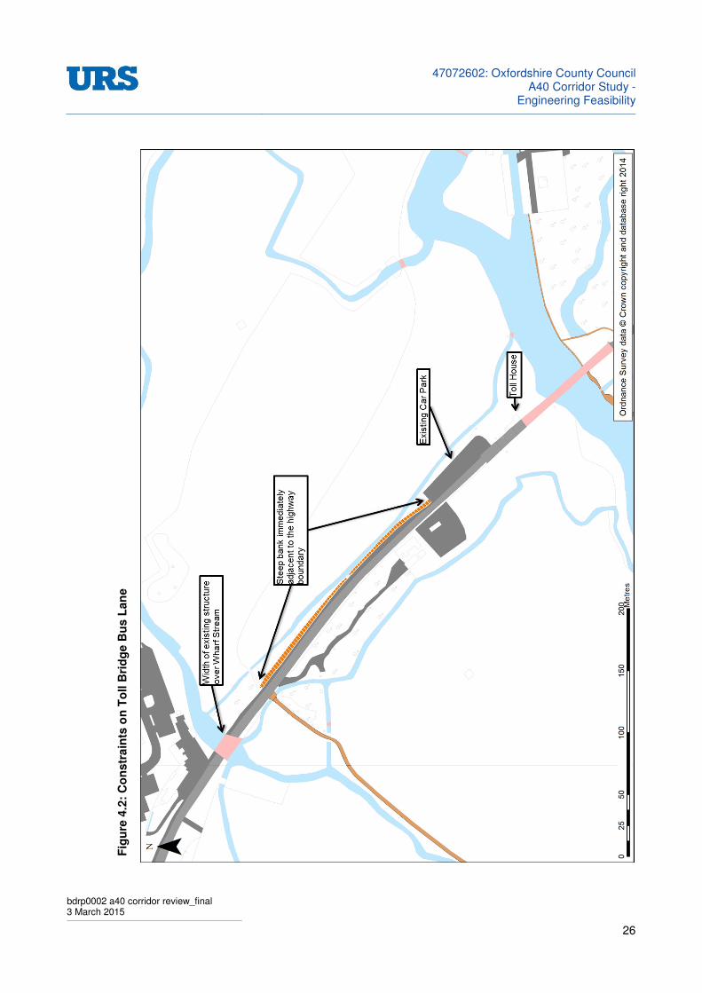
4.1.10 The route for a bus lane on the southbound approach to the bridge would be constrained by a number of obstacles. These are identified in Figure 4.2 running alongside almost the entire length of the B4404 from Wharf Stream to the River Thames including a long stretch of steep bank running immediately alongside the assumed highway boundary.
4 Source: Liaison with West Oxfordshire District Council and Oxford City Council planning officers
47072602: Oxfordshire County Council
A40 Corridor Study -Engineering Feasibility
bdrp0002 a40 corridor review_final 3 March 2015
26
Fig
ure
4.2
: C
on
str
ain
ts o
n T
oll B
rid
ge B
us L
an
e

47072602: Oxfordshire County Council
A40 Corridor Study -Engineering Feasibility
bdrp0002 a40 corridor review_final 3 March 2015
27
4.1.11 The Highway boundary appears to follow a fence line offset approximately one metre from the edge of a footway along the eastern side of the carriageway. While this would not preclude the construction of a southbound bus lane it is likely that land would need to be purchased with earthworks along much of the length of the lane. The benefit from this may be exceeded by the cost.
4.2 Treatment for Swinford Toll Bridge
4.2.1 The findings of the Toll Bridge Study are inconclusive. While delays and congestion will be reduced in the base year there is no consideration of growth associated with significant local development pressures over the plan periods for West Oxfordshire and Oxford City. It is therefore likely that any benefits secured through automatic toll collection may be short term, with the present issues recurring in the medium to long term. In addition to this the route along the B4044 incorporating Swinford Toll Bridge may not be suited to the additional traffic that will be attracted to it by reducing the existing level of delay.
4.2.2 A review of constraints on the southbound approach to the toll bridge suggests that installation of a bus lane would be technically feasible. It would require land purchase and substantial earth works when the scale of the scheme is taken into consideration. It seems likely that the benefits of providing a segregated bus lane may be outweighed by the potential costs. More detailed site investigation and benefits analysis would be required to confirm this.

47072602: Oxfordshire County Council
A40 Corridor Study -Engineering Feasibility
bdrp0002 a40 corridor review_final 3 March 2015
28
5 REUSE OF WITNEY AND CARTERTON RAILWAY ROUTE
5.1 Introduction
5.1.1 This section of the report is concerned with potential rail based public transport solutions ideally making use of disused Oxford to Fairford railway corridor.
5.1.2 The overall study remit is to carry out an initial feasibility and design for a range of options to improve transport along the A40 corridor. The principal focus is to be the section between Oxford and Witney however consideration is also to be given to the routes to Carterton in the West and Headington/ Marston in the East.
5.2 A40 Witney – Oxford Corridor Route Strategy Baseline Statement
5.2.1 The A40 Witney – Oxford Corridor Route Strategy Baseline Statement is focused on finding a scheme that will provide relief to the traffic congestion currently being experienced on the A40 west of Oxford. Current traffic flows are forecast to continue increasing for the foreseeable future. The statement identified a number of potential options for the longer term strategy of which the following are either rail based or in the case of the Guided Busway will make use of the disused railway formation:
• Guided busway
• Rail line (Carterton-)Witney-Oxford
• Tram/train light rail line (Carterton-)Witney-Oxford
• Non-conventional rapid transit systems
5.2.2 It should be noted that this is an initial high level study intended to confirm technical feasibility of the various options. The specific infrastructure and operational issues have not been examined in detail.
5.3 Oxford – Witney – Fairford Railway
5.3.1 The Oxford Witney and Fairford railway was constructed between 1861 and 1873 as a single line railway with passing loops at the seven stations along the route. In 1962 it was closed to passenger traffic with the section between Yarnton junction and Witney remaining open to freight traffic until 1970 when it was finally closed.
5.3.2 The line ran from Yarnton junction on the ‘Cotswold Line’ (formally known as The Oxford, Worcester and Wolverhampton Railway) south and west through Eynsham, Witney Brize Norton and on to terminate at Fairford. All railway infrastructures have been removed and only sections of the disused formation remain.
5.4 Disused Railway Route
5.4.1 The topography of this part of Oxfordshire is generally low relief. There are few hills of any significant height and river valleys are relatively shallow with gently sloping sides. As a result of this the old Oxford Witney and Fairford railway was constructed without the need for major earthworks and much of the route is ‘at grade’.
5.4.2 The branch line started at Yarnton Junction, which is on the Cotswold line approximately 4 miles by rail from Oxford Station. From Yarnton Junction the route passed through what is now the Hanson’s Quarry site. The old track formation has been surfaced to provide an access road for the quarry. The quarry access road follows to old track alignment South West and through a bridge under the A40. Two slip roads one either side of the A40 branch off to the east and ramp up to the road giving access to the East and West bound carriageways of the A40.
5.4.3 The route continued in a South Westerly direction crossing the river Evenlode and the old canal. The two railway bridge spans remain and are now used by pedestrians.

47072602: Oxfordshire County Council
A40 Corridor Study -Engineering Feasibility
bdrp0002 a40 corridor review_final 3 March 2015
29
5.4.4 The alignment turned to the West passing south of the village of Eynsham. Just south east of Eynsham a Siemens industrial depot has been built adjacent to the former railway route and a section of the old formation has been surfaced to provide an access road to the site now named Wharf Road.
5.4.5 The route then crossed the Oxford Road (B4044) where the former level crossing has been removed and a roundabout constructed on the line of route. The next 1.25km of the old formation has been used for a section of the B4449 by-passing Eynsham, leading to a second roundabout on the Stanton Harcourt Road (B4449). Immediately west of this roundabout the site of the former Eynsham station has been occupied by the Oxfordshire County Council Countryside Service building. Once again the actual track formation has been used as an access road and for car parking.
5.4.6 The route continued across open countryside. The old railway had very little earthworks and much of this section has now been reabsorbed into adjacent agricultural land and is under cultivation. The route then crossed the Chillbridge Road where there was previously a level crossing and continued across fields traversing the Limb Brook South East of South Leigh village.
5.4.7 On the Eastern side of the level crossing on the Stanton Harcourt Road (unclassified) a bungalow has been built very close to the old formation and the track bed forms part of the garden of this property. On the Western side of the road some older buildings, possibly former railway buildings connected with South Leigh station lie on the south side of the old railway. A residential building occupies the site of the former station.
5.4.8 The rail route continued on towards Witney. The formation remains largely undisturbed, having been used for minor agricultural access tracks. At Tar Road the old bridge over the railway remains in place although the formation west of the road has been incorporated into the gardens of adjacent building.
5.4.9 From here the alignment the route then swung slightly North West across open fields to meet the A40 East of Witney. The A40 cuts across the old railway alignment and the formation on the north side of the road, which includes the old goods yard and Witney station, has been redeveloped as the Two Rivers Industrial Park. The rail route through Witney has been redeveloped with a range of industrial and commercial developments; mostly car parking. The old formation re-emerges on the south side of the A40 West of Witney.
5.4.10 The route continued over open countryside crossing the Collwell Brook and a country lane leading to Curbridge. This section of the route remains largely intact, having been used as agricultural access tracks.
5.4.11 The railway passed below the A4095 via a bridge over the railway, which remains in use and continued South West crossing Highmoor Brook just to the east of the MoD base at Brize Norton airfield. The old railway route passed through the south side of the aerodrome towards Fairford. The section through the airfield has had a number of airfield buildings and access roads built on the old formation.
5.4.12 West of Brize Norton airfield the railway formation remains almost completely undeveloped up to the village of Lichlade-on-Thames West of the A361 where a new housing development has been built on the old formation. From here the route remains all the way up to the site of the former Fairford station, which has been redeveloped as industrial premises.
47072602: Oxfordshire County Council
A40 Corridor Study -Engineering Feasibility
bdrp0002 a40 corridor review_final 3 March 2015
30
6 OUTLINE PRE-FEASIBILITY STUDY (2001) REVIEW
6.1 Pre-Feasibility Study Remit
6.1.1 Carterton/ Witney to Oxford Rail Link Pre-feasibility study report commissioned by Oxfordshire County Council in 2001 explored a number of options for public transport from the west Oxfordshire area along the route of the old railway. Since 2001 the general environment of the west Oxfordshire area has not changed significantly so much of information relating to the physical environment will remain valid. Road traffic has however continued to grow and significant new housing development is expected in the future that will add further demand for transport in the area.
6.2 Key Assumptions of 2001 Study
6.2.1 The Pre-feasibility study based its analysis on the know population of the towns affected and the additional housing development expected. The report estimated the population of Witney as being 22,000 and the Oxfordshire structure plan indicated a further 2,700 dwellings to be constructed by 2011. At Carterton the 2001 population was 13,000 with plans for a further 1,500 new dwellings by 2011. Since the report was issued estimates for the population increase in West Oxfordshire have been revised upwards. Higher populations will enhance the viability of all the proposed options however it is unlikely to alter the relative position of the various options.
6.2.2 The study also assumed that the GTE proposal was likely to be given full approval and it would be logical to integrate transportation proposals with the wider system.
6.3 Transport System Options Considered
6.3.1 The 2001 Outline Pre-Feasibility study looked into the options for reinstating the old Oxford to Witney railway. The principal objectives of the study were to identify the major physical barriers to reinstatement, assess options for overcoming these and assess options for reinstating the railway line or installing an alternative light rail option. A further option to be considered was the Guided Transit Express for Oxfordshire (GTE) or Guided Busway. In summary the options were:
• Reinstatement of Standard Gauge (Heavy) Rail Link
This option is to install a single track rail line similar the arrangement which existed prior to closure in 1970. The route would use as much of the original formation as possible with minor alignment diversions around recent obstructions which would be uneconomical to relocate.
• Light Rail Tram or Tram/ Train System
The tram option would make use of the former railway formation but with larger diversions to allow on-street running through Witney and into Carterton. The alignment would also be diverted to access Oxford possibly making use of Network Rail land adjacent to existing rail tracks. A second option using Tram / Trains was proposed to allow operation of trams on the National rail network.
The report states that a tram route:
‘could be more readily and usefully assimilated’ into the existing environ of the two towns and railway corridor then a heavy rail provision’.
It is not clear what this means or why this should be but the tram would defiantly offer good access and with park and ride provision would be an attractive service. The report suggests these would effetely relieve pressure on the A40. This would have to be
47072602: Oxfordshire County Council
A40 Corridor Study -Engineering Feasibility
bdrp0002 a40 corridor review_final 3 March 2015
31
carefully checked. It also suggests that the system could be extended to Farmoor and Botley and connection made to Pear tree and Redbridge.
• Guided Transit Express (GTE) for Oxfordshire
This is a Guided bus proposal (network) for Oxfordshire and surrounding areas. Core infrastructure would link the city centre with park and ride sites north and south of the city. (Pear tree/ Redbridge) Principal towns of Bicester Witney and Abington
The northern route proposed to make use of a certain amount of operational railway land. At the time of the proposal the development plans for the development of the railway to Bicester had not been fixed. This may now conflict with NR proposals to add additional tracks to the west of the existing main line.
• Combined Carterton / Witney link (Combined with a tram system)
The report pointed out that there is unlikely to be sufficient demand for both a reinstated railway to Witney and a guided bus link. The bus link would require infrastructure developments to allow it to by-pass traffic on the A40. The route also requires space on the existing oxford rail corridors and would be unable to share the disused railway alignment on the oxford Witney route. The option of having a tram and busway sharing the same infrastructure would raise complex operational and safety issues. The conclusion was that the tram and the GTE should be considered as alternative systems.
6.4 Condition of the Railway Route
6.4.1 The report highlighted the various obstructions to the reinstatement of the railway:
• The portion of the route immediately North of the A40 through Hanson’s quarry now serves as an access road with two slip roads onto the A40 avoiding the need for lorries to cross the main road. Reclaiming this part of the route would require have significant impacts on quarrying operations. Quarrying was expected to be completed with site restoration by 2012 but activities would be continuing in other nearby areas and access to the A40 would still be required.
• At Eynsham the industrial units are sited on the old formation (Siemens Depot) and a section of the route has been converted into a road (B4449) and a reinstated railway would require a diversion.
• The report suggests properties have been built on the formation at South Leigh.
• At Cogges Bridge the old station is now a residential property and the railway would have a significant impact on this property.
• The route crosses the A40 south of Witney and a crossing would be required if the railway was to follow the old route. There are also concerns over the environmental impact on the river Windrush and the geology of the area all of which suggest installing a new bridge would be challenging. The site of the old Witney station is now an industrial estate.
• The bridge below the A4095 north of Lew is in need of repair.
• The old route runs south of the air base at Carterton separating the railway from the village. An alternative route north of the base would be preferred.
6.5 Validity of 2001 Study Findings
6.5.1 To follow the URS review of the Report it is considered that these issues remain valid:
• Quarrying activities are understood to be continuing on the Hanson’s site but it is assumed that these will run down over the next few years. The current situation on this is that the current workings have consent to complete extraction by December 2015, after which their consent requires the protected line of the railway to be converted to a
47072602: Oxfordshire County Council
A40 Corridor Study -Engineering Feasibility
bdrp0002 a40 corridor review_final 3 March 2015
32
pedestrian/cycle route to link to the Oxford Canal. However various waste management facilities on the site have permanent consents to operate and may therefore remain. The consultation draft Minerals and Waste Local Plan (February 2014) identified the area south of A40 that takes in the former railway line as one area from which sand and gravel could be extracted in the future. If this was to go ahead then the operators may want to use the current processing plant in which case the obvious route for transporting material would be along the railway line.
• The construction on the old rail route south of Eynsham would be very costly to relocate. A diversion North of the old alignment between the B4449 and the town could be accommodated. This would allow a new station to be sited slightly closer to the town centre than the previous location.
• It is not clear whether the properties at South Leigh are actually on the old formation. They are however very close and would be affected by any reinstatement proposal.
• The old station property at Coggs Bridge would be affected and may have to be purchased and an assessment made as to the need for demolition.
• Crossing the A40 into Witney would be very costly, requiring two new bridges under a dual carriageway. The land on the Witney side of the A40 has also been redeveloped and would incur significant costs if it were to be re-occupied by the railway. The report did not explain specifically what the challenges associated with crossing the River Windrush would be however; it is assumed that this would add additional costs to any construction works. An alternative route south of the A40 would be more practical and would allow more space for a new station and car parking. However there would be technical issues associated with relocating the existing slip roads up to the A40.
• It is assumed that all remaining structures on the route would need major refurbishment or replacement.
• The route across the Air base is no longer practical and in any case bears away from the main population centre at Carterton. An alternative route crossing Station Road North of the air base and terminating on the East side of the town would be more beneficial.
6.6 Option Evaluation
6.6.1 Evaluation of the proposed options identified a number of advantages and disadvantages with each:
• The ‘Heavy rail’ option could not cross the A40 into Witney without unacceptable costs and impacts in the town. As a result passengers using a station south of the A40 would access the site by road requiring car parking and significantly increasing traffic in the local area. The impacts on local environment and commercial activity in the area would also be significant. Amenity at Ducklington Lake would be impaired; the possible demolition of the Hotel and access problems at Hanson’s quarry would count against a rail option. A rail line would connect to the national system at Oxford but this would be of little benefit to local travellers visiting the city of Oxford.
• The light rail option could offer a more direct route into the centres of population although it is not clear that it could cross the A40 any more easily than the heavy rail option. The route could be extended up to the Peartree area although this would require some major engineering works to cross the A44 and A34. The introduction of tram/ trains would allow the system to share existing infrastructure with the Network rail system and give access to Oxford Station but the benefit of this would be as for the heavy rail option. Clearly if it is intended to build a tram system to serve the Oxford and its wider area the Witney route could be viewed in a more favourable light.
• The alternative route into Oxford via Botley offered a more direct connection into the city and avoided interaction with the Network Rail system. A new bridge would be required

47072602: Oxfordshire County Council
A40 Corridor Study -Engineering Feasibility
bdrp0002 a40 corridor review_final 3 March 2015
33
over the Thames and Isis, which could have visual impact issues. Overall the environmental impacts of this option were seen as unacceptable.
• The proposed GTE guided busway offered more flexibility in the routes and destinations that could be served. Sections of the route would operate as a conventional bus route along existing roads into towns and over road junctions; switching to dedicated lanes avoiding congestion on existing roads. It would be relatively easy to connect the system to locations beyond the guide way. There would also be minimal construction impacts in towns. The one drawback of bus based systems is that they can be less attractive to the general public in terms of service quality and comfort compared with a railway.
6.7 Cost Evaluation
6.7.1 Evaluation of proposed cost estimates identified that:
• The study estimates indicated that light rail would be cheaper than heavy rail. Significantly infrastructure costs would be up to 60 per cent less than a heavy rail option. The ‘Heavy rail’ option would be a single track line with passing loops at stations and the infrastructure would include a sophisticated signalling and control system. Some elements such as bridges and under track crossings would need to be designed to support heavier loadings.
• A light rail system could have double tracks for the whole route or could be a single track with passing loops. Operation of a single track tram system would also require some form of signal control. In addition the tram system would most probably be electrified the cost of this would offset some of the cost advantage compared with the heavy rail option. Other infrastructure costs would be similar or both options.
• Current figure for the overall costs of rail reinstatement and new light rail projects appear to suggest that costs would be broadly similar. The cost of installing a street running light rail system would be significantly more than the cost of constructing a similar system on a disused railway track bed.
6.8 Evaluation Tables
6.8.1 The Pre-feasibility report included a number of ‘Evaluation’ tables intended to compare the strengths and weaknesses of alternative options, with a view to identifying a preferred solution. As this was an outline study this was a subjective evaluation. Base considerations were adjusted against cost and summed to provide an overall figure for comparison.
6.8.2 Option 1 ‘The reinstatement of the ‘Heavy’ railway was given very low values for passenger experience and financial viability of 2 per cent. While it is likely to be one of the more expensive options to operate it would not be so far from the cost of a new tram system, which was evaluated at 20 per cent; a tenfold difference.
6.8.3 The evaluation of passenger experience is also counter intuitive. The ‘Heavy’ rail option was valued at 2 per cent and the tram as 20 per cent. Experience with the kind of demographics found in West Oxfordshire would suggest that ‘Heavy Rail’ would attract a higher passenger experience evaluation then a Tram which would in turn be viewed as more attractive than a road based public transport system.
6.8.4 In terms of capital costs the road based system would be expected to be the lowest with the tram being lower and nearer to the cost of heavy rail. The costs of construction for the guided sections of the GTE would be not dissimilar to the installation cost of the rail based systems however, the overall route would include sections of running on existing public roads and the overall costs are likely to be lower.
47072602: Oxfordshire County Council
A40 Corridor Study -Engineering Feasibility
bdrp0002 a40 corridor review_final 3 March 2015
34
6.8.5 Much lower figures were also given for external approvals (Planning) construction impacts and permanent operational impacts. It is difficult to see why planning approvals should be so different for Heavy Rail and Tram systems. Planning will be more onerous than for the other options due to the need for demolitions and level crossings however, for the remainder of the route the requirements are likely to be similar to those for a tram. Construction of a ‘Heavy’ rail line will have less impact on local people than a tram system with street running.
6.9 Conclusions from 2001 Study
6.9.1 The Pre-feasibility study did not recommend any of the options considered but did recommended that local views should be canvassed and further studies undertaken to establish the likely levels of patronage for each of the options.
6.9.2 Specific conclusions were mentioned:
• Paragraph 3.8.1 - A new the rail link would be in direct competition with any proposed GTE guided busway system and it would be preferable to combine the two options as a single scheme.
URS Comment: This is a logical conclusion. Whether the overall GTE project remains a viable option would require further study of its installation costs and its likely patronage.
• Paragraph 3.8.2 - The balance of cost / benefit / impacts of the tram / light rail and the guided busway options would be broadly comparable.
URS Comment: The cost of each system would be heavily dependent on the details of its alignment and the infrastructure proposed. If the light rail system was to be extended with ‘street running’ into the towns along its route it can be expected to be significantly more expensive than a guided busway.
• Paragraph 3.8.3 - The heavy rail option was discounted as it was seen as presenting unacceptably high impacts with questionable benefits and high construction costs.
URS Comment: The report did not make it clear why the impacts of the heavy rail option were considered unacceptably high compared with the impacts of the other options. The benefits would be largely derived from the patronage the system attracts, which would be linked to the chosen route, location of Oxford station, overall convenience and cost of travel. Construction costs would be high however; a tram system would also be costly. One possible impact would be potential delays to road traffic at level crossings if it is decided to reinstate these along the route. A tram system would also require level crossings although these would not require barriers and would be controlled with conventional highway light controlled traffic signals.
• Paragraph 3.8.4 - Alignment considerations for the guided busway and light rail systems should be limited to the northerly alignment of the disused railway. Alternative alignments via Botley and Thames valley were discounted on the basis of environmental impacts.
URS Comment: Previous studies have indicated that the environmental impacts of the Botley route would be significant.
• Paragraph 3.8.5 - The cost estimate for the combined system was estimated at between £70 and £100m excluding land purchase and project costs.
URS Comment: These costs relate to 2001. Price inflation and more resent experience of construction of these systems would allow these figures to be updated.
• Paragraph 3.8.6 - Further consideration would be necessary to establish the need for alternative transport modes to the currently proposed guided bus and A40 bus lanes. Initial considerations suggesting a combined population of Carterton and Witney may be too small to furnish the minimum patronage required to be financially viable.
URS Comment: An outline assessment of operating costs suggested that considerable patronage as a percentage of the local population would be required and in view of the
47072602: Oxfordshire County Council
A40 Corridor Study -Engineering Feasibility
bdrp0002 a40 corridor review_final 3 March 2015
35
other modes available it was thought unlikely that this would be realised. Since this study was undertaken the population of the west Oxfordshire area has grown and is projected to grow further in the near future.
6.10 Concluding remarks - System Options
6.10.1 The pre-feasibility report rejected the heavy rail option on grounds of its cost and unacceptable impacts. The cost of reconstructing the rail route would not necessarily be significantly higher for heavy rail verses light rail or a guided busway. The Major issue with all of these options would be obtaining access to the land which has been sold to various private and public owners. Construction of the new infrastructure would remain the major proportion of the cost but the differences between the various options would be a smaller proportion of the overall cost.
6.10.2 The most important question is whether the rail system might be expected to attract a higher volume of passengers and a more significant modal shift in the area. The demand forecasts used in the feasibility report suggest that there is unlikely to be sufficient demand to match the cost of the investment.
6.10.3 While there would undoubtedly be some adverse impacts on the environment and current highway traffic flows, these do not appear to be significantly more than for the tram option.
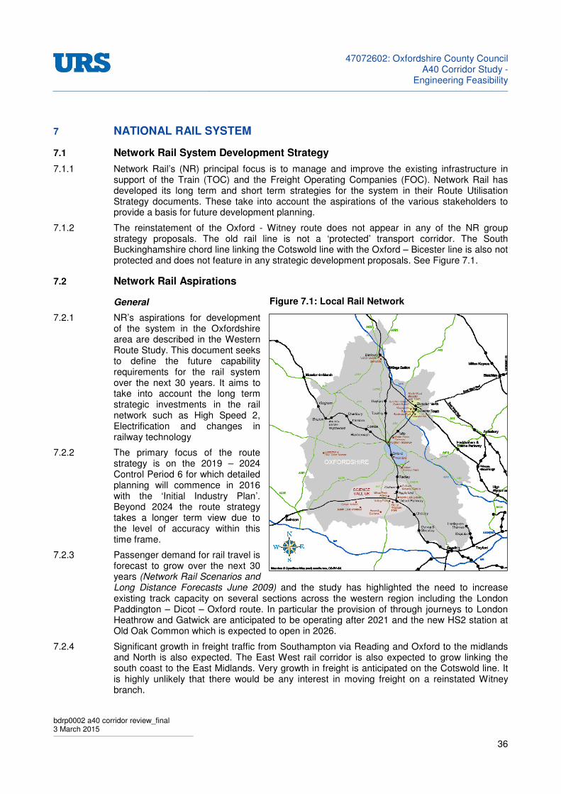
47072602: Oxfordshire County Council
A40 Corridor Study -Engineering Feasibility
bdrp0002 a40 corridor review_final 3 March 2015
36
7 NATIONAL RAIL SYSTEM
7.1 Network Rail System Development Strategy
7.1.1 Network Rail’s (NR) principal focus is to manage and improve the existing infrastructure in support of the Train (TOC) and the Freight Operating Companies (FOC). Network Rail has developed its long term and short term strategies for the system in their Route Utilisation Strategy documents. These take into account the aspirations of the various stakeholders to provide a basis for future development planning.
7.1.2 The reinstatement of the Oxford - Witney route does not appear in any of the NR group strategy proposals. The old rail line is not a ‘protected’ transport corridor. The South Buckinghamshire chord line linking the Cotswold line with the Oxford – Bicester line is also not protected and does not feature in any strategic development proposals. See Figure 7.1.
7.2 Network Rail Aspirations
General
7.2.1 NR’s aspirations for development of the system in the Oxfordshire area are described in the Western Route Study. This document seeks to define the future capability requirements for the rail system over the next 30 years. It aims to take into account the long term strategic investments in the rail network such as High Speed 2, Electrification and changes in railway technology
7.2.2 The primary focus of the route strategy is on the 2019 – 2024 Control Period 6 for which detailed planning will commence in 2016 with the ‘Initial Industry Plan’. Beyond 2024 the route strategy takes a longer term view due to the level of accuracy within this time frame.
7.2.3 Passenger demand for rail travel is forecast to grow over the next 30 years (Network Rail Scenarios and Long Distance Forecasts June 2009) and the study has highlighted the need to increase existing track capacity on several sections across the western region including the London Paddington – Dicot – Oxford route. In particular the provision of through journeys to London Heathrow and Gatwick are anticipated to be operating after 2021 and the new HS2 station at Old Oak Common which is expected to open in 2026.
7.2.4 Significant growth in freight traffic from Southampton via Reading and Oxford to the midlands and North is also expected. The East West rail corridor is also expected to grow linking the south coast to the East Midlands. Very growth in freight is anticipated on the Cotswold line. It is highly unlikely that there would be any interest in moving freight on a reinstated Witney branch.
Figure 7.1: Local Rail Network

47072602: Oxfordshire County Council
A40 Corridor Study -Engineering Feasibility
bdrp0002 a40 corridor review_final 3 March 2015
37
Main Didcot – Birmingham Route
7.2.5 The existing infrastructure between Didcot and Oxford is expected to be significantly constrained following the growth in services proposed in Control Period 5 (2014-2019) Any subsequent increase in services levels will lead to requirements for infrastructure enhancements. This is expected to require grade separated junctions at major intersections such as Didcot and possibly North of Oxford, four-tracking between Didcot and Oxford and additional platforms at Oxford station.
Cotswold Line
7.2.6 The anticipated service pattern on the North Cotswolds route is for one train per hour through to London Paddington, and one freight train per day. Freight traffic is not forecast to increase. Should passenger demand continue to grow an additional one train per hour local service possibly terminating at Oxford may be provided. In this event investment may be required on the North Cotswold line between Oxford and Worcester particularly at Hanborough and Charlbury.
7.2.7 The route study has considered the option of doubling the currently single track line between Oxford and Worcester to accommodate possible 2 trains per hour service level. It is currently believed that increasing the service frequency at Oxford may provide sufficient capacity to service the demand growth. If this option was to be achieved by extending services from London Paddington currently terminating at Oxford onto the Cotswold line then the possible electrification of the route between Wolvercote Junction and Hanborough or Charlbury would need to be considered.
7.2.8 Good accessibility is at the heart of attracting passengers to rail travel. This includes provision of car parking, walking and cycling routes and an interchange with other transport modes such as taxis and buses. Hanborough in particular with its role as a railhead for the North West Oxfordshire area has significant issues in providing for passenger access.
Buckinghamshire Railway
7.2.9 East West Rail is intended to reintroduce direct passenger services through Oxford to Bletchley and Milton Keynes. It is seen as improving East West connectivity and will help in alleviating traffic congestion problems in Oxford. Phase 1 is planned to provide a half hourly service between London Marylebone and Oxford via a new Oxford parkway station to be built at Water Eaton.
7.2.10 Beyond the proposed half hourly service there is currently no additional capacity available to accommodate more trains crossing from the Bicester, Milton Keynes or Marylebone direction. (East West rail Route). The addition of a grade separated junction north of Oxford and the provision of four tracks between Oxford and Didcot are possible interventions. Both these solutions would however require the provision of a fourth through platform on the east side of Oxford station.
Cowley Branch
7.2.11 East west rail will increase the requirement for ‘lay-over’ time; Trains held on platforms awaiting their timetabled departure. Oxford County Council is developing proposals with Chiltern Rail to operate a service along the currently freight only Cowley branch. This will provide a rail service to the south side of the city and allow rolling stock to lay-over away from the main Oxford station.
47072602: Oxfordshire County Council
A40 Corridor Study -Engineering Feasibility
bdrp0002 a40 corridor review_final 3 March 2015
38
The South Buckinghamshire Chord Line (SBCL)
7.2.12 Reinstatement of this link is technically practicable, although it would be very costly and disruptive to highway traffic. It would require reconstruction/ relocation of the Loop Farm roundabout (A44), which has been built at a low level; or alternatively, construction of a bridge over with a second bridge over the A34 before ramping down to join the railway and then passing beneath the Oxford Road Bridge at Water Eaton.
7.2.13 All this would involve significant bridge works and supporting earthworks. One domestic property adjacent to the Loop Farm roundabout would have to be acquired for demolition. The benefits of adding this infrastructure would be to allow services on the Cotswold line to link into Water Eaton and possibly through to London via Bicester. It would offer no benefit to traffic to and from Oxford other than removing some potential London traffic which might congest Oxford station.
7.2.14 In the reverse direction it would link the east midlands and London to the west Oxfordshire and Cotswold area via an alternative route. From a railway operational point of view this would have few attractions. Services to and from the west would have to be split between Oxford and Water Eaton; leading to less frequent services to and from the city of Oxford and raising operational costs for a limited demand wishing to visit water Eaton and beyond.
Oxford Station Master Plan
7.2.15 In July 2014 NR, Oxford City Council and Oxfordshire County Council launched a consultation on the outputs from the Oxford Master Plan. The plan (CP5 2019-43) proposes a number of enhancements to the station area to provide for future growth through regeneration of the west end of Oxford. The aim of the master plan is to create an exemplary gateway to the city and meet the long term needs of the railway. Particular features of the master plan are a new station building, new platforms and better transport interchanges. There is also to be a new multi-story car park along with commercial and residential development adjacent to the railway.
7.2.16 The railway’s strategic focus is on increasing capacity at Oxford and improving journey times on the Cotswold line. The current layout of Oxford station means that empty stock movements have to cross at the north end of the station between arrival and departure which restricts the overall station capacity. Improvements are planned for the rail junction North of Oxford station.
7.2.17 Platform capacity at Oxford station is expected to be full by 2019 and additional station capacity will be required to accommodate the anticipated growth in rail passenger throughput in forecast for Network Rail’s Control Period 6 (CP6). A new through platform is proposed on the eastern side of the station under CP5, with a new through platform proposed for the west side to be developed under CP6.
The Electric Spine
7.2.18 The ‘Electric Spine’ project is intended to create a high capacity passenger and freight electric corridor running from the south coast through Basingstoke, Oxford, Leamington Spar Coventry and Nuneaton to the west midlands and the North West. It also includes the route via East West rail from Oxford to Milton Keynes, the West Coast Main line and to Bedford and the Midland Main Line. The plan is to electrify from Didcot to Oxford in the initial phase (CP4) with the Oxford to Bletchley being developed in parallel with East West Rail Phase 2.
7.2.19 In 2011 the government confirmed its commitment to the electrification of the Great Western Main Line and the further extension of the programme to include the Thames valley branch lines. The route between Paddington and Oxford is planned for completion by December 2016. The electrification is to be extended further north to Bicester and beyond under CP5 – 2019 and beyond. Electric trains will deliver journey time improvements and allow operation of longer trains offering increased seating capacity.
47072602: Oxfordshire County Council
A40 Corridor Study -Engineering Feasibility
bdrp0002 a40 corridor review_final 3 March 2015
39
Intercity Express Programme (IEP)
7.2.20 The IEP provides a new generation of trains to be known as ‘Super Express Trains’ (IET) catering for longer distance travel on intercity or outer suburban routes. These will replace the HSTs currently operating on the Western region. These trains will be electrically powered although some units will be Bi-mode and able to operate on electrified and non-electrified routes. The IETs will increase speeds on the North Cotswold route and help in enhancing capacity at Oxford station.
Resignalling Programme
7.2.21 A major re-signalling programme is already underway in advance of the electrification of the GWML in CP5. Oxford area re-signalling is due to be completed by 2017. This will relieve some of the operational constraint of the junctions at the North end of Oxford. It is expected to improve traffic flows into and through Oxford allowing increased services and reducing journey times.
7.3 Train Operating Company (TOC) Aspirations
First Great Western
7.3.1 First Great Western (FGW) has no development proposals for the Witney branch under consideration and they do not view it as a high priority addition to their rail routes. They would be concerned that reinstatement of the Witney branch would deliver few benefits in terms of increased passenger numbers and would compete with services on the North Cotswold line. Their aspirations for the West Oxfordshire area are currently focused on improving services on the North Cotswold line. Specifically they would like to develop the station at Hanborough which is the nearest station to Oxford serving this area. A north Cotswold stakeholder board is to be formed to assist in developing the improvement strategy.
7.3.2 The existing Hanborough station has a single face platform and very limited car parking. FGW would like to enhance these facilities possibly with a second platform on a double track railway and greatly improved car parking capacity. If the route was to be double tracked into Oxford services could be increased to half hourly with hourly local services and hourly services through to London.
7.3.3 Hanborough station has major road access issues. The access to the rail station is very narrow and there are severely limited parking spaces. The station access road also forms the rear access to the Oxford Bus Museum. The Lower road from Eynsham is restricted by the narrow rail bridge through which traffic passes in single file. The junction with the main road into long Hanborough may also need some improvement. The bridge over the railway leading south leading directly towards Witney is also narrow. There is no direct route to Carterton and traffic need to cross the A40 at Curbridge or use the B4477 and the B4047 via Charterville Allotments and Minster Lovell to join the A4095 on the north side of Witney.
7.3.4 FGW believe some road improvements would assist in traffic accessing Hanborough station; also improving bus links. FGW are working with Oxfordshire County Council in developing car parkin Previous proposals have included providing a new access road to the west of the station down from the A4095 to an additional car park. A platform would be linked to the existing station with a new footbridge.
7.3.5 There is no significant car parking space available at the next stations along the line at Combe or at Finstock. Both stations are accessed by narrow roads and have limited drop off areas.
7.3.6 FGW see significant demand growth on the Cotswold line. Some services currently using the route have long layovers at Oxford occupy valuable platform space.

47072602: Oxfordshire County Council
A40 Corridor Study -Engineering Feasibility
bdrp0002 a40 corridor review_final 3 March 2015
40
Chiltern Railways
7.3.7 Chiltern Railways (CR) is interested in delivering services on the Cowley branch line. This will allow the South side of Oxford to be served by rail. A test train ran to Cowley in November 2014. One of the drivers for this service is that Chiltern will require long layover periods for its proposed Bicester services. Hence the use of the Cowley branch will allow trains to layover at Cowley without occupying platform space in Oxford station.
7.3.8 CR currently has no plans for operating services on the North Cotswold line or developing a route through to Witney and Carterton.
7.4 Oxfordshire County Council Aspirations
7.4.1 Oxfordshire County Council would like to alleviate traffic issues between Oxford and Witney/ Carterton, both at the current time and into the future. In the short term this is primarily focused on the issue of traffic congestion along the A40 route west of Oxford. In the short term any of the options under consideration would be measured against their likelihood to affect traffic on the A40. The council does have longer term aspirations to address the transportation system in West Oxfordshire and major investments in sophisticated transport schemes may become justified as worthwhile investments.
47072602: Oxfordshire County Council
A40 Corridor Study -Engineering Feasibility
bdrp0002 a40 corridor review_final 3 March 2015
41
8 NON-CONVENTIONAL TRANSPORT SYSTEMS
8.1.1 A number of alternative non-conventional transport options could be considered for the Oxford to Witney route.
8.2 Tram / Train,
The Tram/ Train Concept
8.2.1 Tram-train is a concept as yet unaccepted by the rail authorities (DfT and ORR [HMRI]) for operation on UK tracks, but is in service in continental Europe. It is a vehicle based on tram technology which also carries a prime mover (typically a diesel-electric generator) on board and is able to operate both on a tramway network and standard national rail lines.
Crash Worthiness
8.2.2 This is a particularly significant area and an often overlooked issue. Newly built heavy rail trains must meet HMRI crash protection standards, and these were significantly tightened during the 1990s. Large fleets of older trains, with strong underframes but light-weight body shells which were built from the 1950s to the 1970s were withdrawn wholesale in order to improve the safety position of the UK rail fleets as a whole.
8.2.3 Any vehicle that operates on tracks amongst standard (Heavy) trains must meet the required standard of crash worthiness. The Network Rail is currently undertaking tram-train trials on the Sheffield-Huddersfield route which are intended to work out a future formula for such operations considering such issues as:
• Vehicle specification
• Crash worthiness standards;
• Signalling interfaces;
• “Permissive Block” working (or “line of sight” driving);
• Operating costs; and
• Passenger perception.
8.2.4 This trial, which is being funded by the DfT, was planned to start operation in 2010 using five new tram-train vehicles for two years operating between Sheffield Midland, Meadowhall, Barnsley, Penistone and Huddersfield on Network Rail tracks. If successful a further stage of the trial would see the tram-train vehicle working on the Supertram network beyond Meadowhall and into the Sheffield city centre.
8.2.5 Collision protection legislation does not apply to trams or the people-mover, and as a result even new versions of these vehicles are built with minimal crash protection measures in the design. This is one reason why trams and people movers are lighter than trains.
Acceptance Processes
8.2.6 No special acceptance processes will be necessary to operate with a d.m.u. other than route clearance tests on the new railway, as these designs already have a national safety case. If tram-train were chosen, operating approvals would be necessary both on the tramway and on Network Rail. The former approvals would not be that onerous assuming the body design of the tram-train will be compatible with the new infrastructure. However approval to operate on Network Rail would be expected to be a costly and lengthy process.
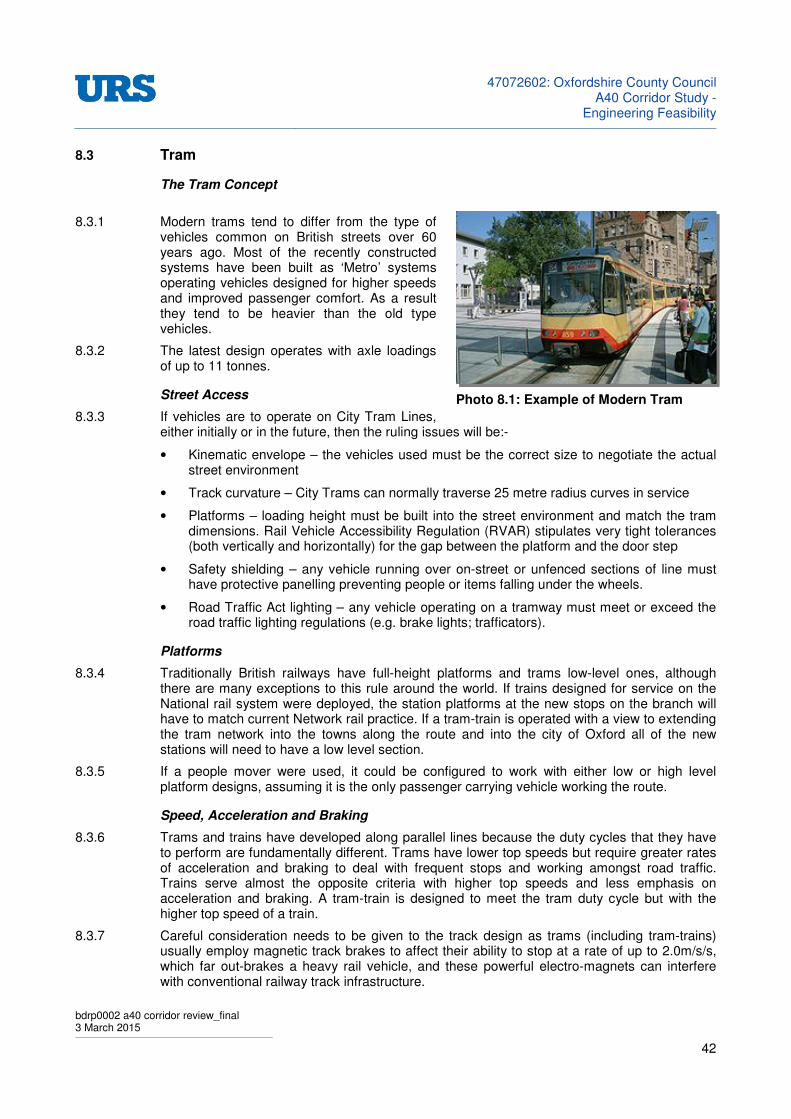
47072602: Oxfordshire County Council
A40 Corridor Study -Engineering Feasibility
bdrp0002 a40 corridor review_final 3 March 2015
42
8.3 Tram
The Tram Concept
8.3.1 Modern trams tend to differ from the type of vehicles common on British streets over 60 years ago. Most of the recently constructed systems have been built as ‘Metro’ systems operating vehicles designed for higher speeds and improved passenger comfort. As a result they tend to be heavier than the old type vehicles.
8.3.2 The latest design operates with axle loadings of up to 11 tonnes.
Street Access
8.3.3 If vehicles are to operate on City Tram Lines, either initially or in the future, then the ruling issues will be:-
• Kinematic envelope – the vehicles used must be the correct size to negotiate the actual street environment
• Track curvature – City Trams can normally traverse 25 metre radius curves in service
• Platforms – loading height must be built into the street environment and match the tram dimensions. Rail Vehicle Accessibility Regulation (RVAR) stipulates very tight tolerances (both vertically and horizontally) for the gap between the platform and the door step
• Safety shielding – any vehicle running over on-street or unfenced sections of line must have protective panelling preventing people or items falling under the wheels.
• Road Traffic Act lighting – any vehicle operating on a tramway must meet or exceed the road traffic lighting regulations (e.g. brake lights; trafficators).
Platforms
8.3.4 Traditionally British railways have full-height platforms and trams low-level ones, although there are many exceptions to this rule around the world. If trains designed for service on the National rail system were deployed, the station platforms at the new stops on the branch will have to match current Network rail practice. If a tram-train is operated with a view to extending the tram network into the towns along the route and into the city of Oxford all of the new stations will need to have a low level section.
8.3.5 If a people mover were used, it could be configured to work with either low or high level platform designs, assuming it is the only passenger carrying vehicle working the route.
Speed, Acceleration and Braking
8.3.6 Trams and trains have developed along parallel lines because the duty cycles that they have to perform are fundamentally different. Trams have lower top speeds but require greater rates of acceleration and braking to deal with frequent stops and working amongst road traffic. Trains serve almost the opposite criteria with higher top speeds and less emphasis on acceleration and braking. A tram-train is designed to meet the tram duty cycle but with the higher top speed of a train.
8.3.7 Careful consideration needs to be given to the track design as trams (including tram-trains) usually employ magnetic track brakes to affect their ability to stop at a rate of up to 2.0m/s/s, which far out-brakes a heavy rail vehicle, and these powerful electro-magnets can interfere with conventional railway track infrastructure.
Photo 8.1: Example of Modern Tram

47072602: Oxfordshire County Council
A40 Corridor Study -Engineering Feasibility
bdrp0002 a40 corridor review_final 3 March 2015
43
Signalling
8.3.8 It is normal for trains to carry signalling interface equipment, commonly AWS and TPWS which help to prevent the passing of signals at danger. Trams usually only carry traffic light interface kit to give them priority at selected road junctions, and usually drive under normal highway code regulations which is termed “permissive block” or “line-of-sight driving” on railways.
8.3.9 It would be a vital item in the crashworthiness argument that a tram-train or people mover at least carries AWS/TPWS equipment and that the drivers be as fully trained as a Network Rail driver in order to minimise the chance of a collision in the first place.
8.3.10 Furthermore any tram-train or people-mover intended to operate on Network Rail will need to operate track circuits with reliability, which may need the fitting of additional equipment (e.g. under-body track circuit loops), though its operation on a segregated track could be by “line-of sight” driving and would therefore not need formal signals.
8.3.11 Equally there is no reason why a tram-train or people-mover could not operate on signalled sections, as is done at Manchester Metrolink
8.4 People Movers
The People Mover Concept
8.4.1 The people mover, as marketed by Parry Associates, is in principle a light-weight rail-born vehicle with a hybrid drive, which is designed to consume as little energy as possible in its operation. It is sometimes referred to as “Ultra-Light Rail”. It has very little in common with any existing heavy rail trains or light rail trams.
8.4.2 It has had some limited success operating on short branch lines away from other types of train, and indeed two single-car vehicles (class 139) are being delivered currently to the operator London Midland to work the Stourbridge branch in the West Midlands on Sundays.
8.4.3 The people-mover is a strong underframe plus lightweight body design, and those built to date lack any crash worthiness measures. However the people-mover concept is one centred on the hybrid drive system, and so the design of the body could be very different, indeed could be much closer to accepted heavy rail principals, and the drive system could be increased in power to match. Current people-mover cars have twin axles however a concept design with bogies exists. This would add weight but would improve the ride, especially on indifferent track.
8.4.4 In Germany and France, tram-train vehicles, which have to share tracks with heavy or fast passenger and freight trains, have incorporated a degree of crash protection and, any such tram-train in the UK must do the same. But the European standards used there have so far not been accepted by Network Rail (hence the Sheffield-Huddersfield trial operation). If the people-mover were chosen, the only possibilities for its approval to run on existing track were if it were:
• To have a body-shell built with appropriate crash protection (as for tram-train); or
• For it to be operated on an entirely segregated track.
Photo 8.2: A Class 139 (PPM 60) Parry People Mover
47072602: Oxfordshire County Council
A40 Corridor Study -Engineering Feasibility
bdrp0002 a40 corridor review_final 3 March 2015
44
8.4.5 It is conceivable that a people-mover could be configured to operate along a tramway system, though in the case of this study, it could obviously only do so and travel onto Carterton if it were to also gain approval to operate on Network Rail, which as discussed above, would be a major undertaking.
47072602: Oxfordshire County Council
A40 Corridor Study -Engineering Feasibility
bdrp0002 a40 corridor review_final 3 March 2015
45
9 DISUSED RAILWAY LINE OPTIONS
9.1 Short Term Solutions
9.1.1 The limited budget available to OCC offers little scope in developing new dedicated public transport options. In dealing with the specific issue of traffic congestion on the A40 west of Oxford there are few obvious rail based solutions that could be delivered within the limited budget available. Any developments affecting the railway will require the cooperation and support of the infrastructure owner Network Rail and the Train operating companies.
Hanborough Station
9.1.2 The only short term option identified that might impact traffic flows in this area would be to promote enhancements to road access and car parking at Hanborough Station. These works would be undertaken in partnership with the Bus service operators, Network Rail and the Train operator First Great Western. Improved access would remove one of the major factors deterring travellers from using this station Enhanced rail services would attract travellers to both Oxford and longer distance journeys.
Cowley Branch
9.1.3 Chiltern Railways have already started to develop proposals for extending their services from the Oxford – Bicester route to Cowley. This will provide rail access to south Oxford linking to the Water Eaton and the car parking facilities in the Peartree area. Whilst this scheme will have clear benefits to public transport in Oxford it is unlikely to have any impact on traffic using the A40.
9.2 Longer Term Solutions
9.2.1 Rail both light rail and ‘heavy’ could make an impact on travel patterns in the West Oxfordshire area. These options are likely to require considerably larger budgets and should be considered as longer term investments. The projected growth in population in the west Oxfordshire area will feed demand for local and intercity travel. Whether any of these schemes will alleviate traffic congestion on the A40 on their own is doubtful, although they could make a significant contribution as part of the overall transport offering.
9.2.2 A number of options have been considered as described below. All these options carry significant investment requirements and will need careful consideration of the demand and operational cost in building a business case for such an investment.
Reinstatement of Witney to Oxford Branch Line
9.2.3 The level of service offered on a light or ‘Heavy’ rail line would be dictated by the level of demand. From the rural nature of the West Oxfordshire area it is unlikely that anything more than a half hourly ‘Heavy’ rail service would be required. Generally light rail can offer a more frequent service using more vehicles but with lower individual capacities. A more intensive level of service will require more investment in vehicles and in the case of the ‘Heavy rail’ a more extensive signalling and control system.
9.2.4 The proposal would be to reinstate the Witney branch along its original alignment. The railway would make as much use as practicable of the dismantled railway route. This would help to minimise impacts caused by developments of other developed land or undeveloped areas. The fact there was previously a railway along the route suggests that it should be possible to reinstate a modern railway on the old formation without major new earthworks.
47072602: Oxfordshire County Council
A40 Corridor Study -Engineering Feasibility
bdrp0002 a40 corridor review_final 3 March 2015
46
9.2.5 Sections of the route that have been put to other uses will present particular challenges. If access cannot be obtained to the old route, the railway will need to be diverted over adjacent land, which could raise a number of issues in terms of engineering, environment and cost. Allowance should also be made for costs associated with upgrading/ laying additional track over the section from Oxford station to Yarnton junction (3.3 miles).
9.2.6 From Yarnton junction to Carterton the remaining track formation will require complete refurbishment and there are likely to be significant ancillary works; reconstruction of bridges, drainage works and adjustment of buried services for example. The route has comparatively few structures and no major earthworks although, this has to be balanced by the additional engineering works required for the short lengths of diversions to avoid more recent developments. While costly, these obstacles are not insurmountable in terms of engineering.
9.2.7 The diversion at Witney would be between the old alignment and the south side of the A40. Some complex engineering works would be required tom divert the slip roads from the A40 over the new railway. The new Witney station could be sited near to the sewage treatment plant with additional car parking provided adjacent to the station. This location would allow most of Witney to be within a 500m walk of the station. Other travellers would be expected to drive or use buses.
9.2.8 At Carterton the railway could be diverted north from the original alignment to pass between Brize Norton and Carterton itself to a new terminus station on the East side of the town. Again ample car parking will be required. A significant proportion of the town will be within walking distance of the station but a proportion of the potential users would be expected from the wider area and will be travelling by bus or car.
9.2.9 As was described in the Pre-feasibility report this railway would be maintained as infrastructure segregated from its surroundings, built to current railway engineering standards.
9.2.10 Table 9.1 provides commentary on other considerations related to issues associated with the re-instatement of the Branch Line concept.
Table 9.1: Reinstatement of Branch Line - Additional Design Considerations
Level Crossings
• In the interests of safety National Rail is attempting to remove as many level crossings from the system as possible. This often involves expensive engineering works in replacing these with bridges or closing roads. Often in rural districts roads have been closed and traffic diverted onto alternative routes.
• The nature of the west Oxfordshire environment suggests that road closures would only be practical in a limited number of cases. Equally there are likely to be technical difficulties in installing new bridges in some locations. A number of new level crossings will be required if the railway is reinstated. This may require some effort with the ORR to gain approvals.
Environmental Impacts
• Following the existing route will help to minimise the environmental damage. However since the closure of the railway some sections have become overgrown and will be providing significant wildlife habitat. Removing these for a new railway will allow some sections along the fence lines to remain and may species will recolonize these embankments. Some sections of the route have been taken into agricultural land and turned in to rural mono cultures. Reinstating the railway may have a positive benefit to wildlife habitat.
• Reinstatement will give rise to land severance issues particularly in locations where the rail formation has been incorporated into the surrounding agricultural land or where the
47072602: Oxfordshire County Council
A40 Corridor Study -Engineering Feasibility
bdrp0002 a40 corridor review_final 3 March 2015
47
old formation has been used as an access track.
• Route diversions near Witney and Carterton will require acquisition of currently undeveloped land. The potential impact on Ducklington Lake will be a significant issue and additional space will be required for new stations, car parking facilities and access roads.
• The new stations will attract passengers arriving by car and generating new traffic flows on local roads. Additional highway enhancement works may be required to accommodate this.
• Some of the former railway buildings, stations and crossing keeper’s cottages have been converted into residential use with the assumption that the railway is no longer operating. Reinstating the railway might require the purchasing of these properties for demolition or paying substantial compensation.
• Some of the former railway buildings, stations and crossing keeper’s cottages have been converted into residential use with the assumption that the railway is no longer operating. Reinstating the railway might require the purchasing of these properties for demolition or paying substantial compensation. Noise and visual intrusion are not expected to be significant compared with the other options presented.
Water Courses
• It is likely that any of the original railway drainage that remains will have fallen into disrepair or in some sections will have been removes altogether. The generally low relief of the area and the lack of any significant earthworks suggest that impacts on existing water courses will be minimal. Alternative guided busway options using sealed surface roads will have a much more significant impact on drainage.
Alternative Routes
• An alternative route running north of the A40 to Witney has been suggested. This route avoids the need to cross the A40 and would offer a more direct connection to Eynsham and Witney. The proposal would end at Witney as it could not connect to Carterton without crossing the A40. This leaves this option remote from one of the principal potential demand centres.
• This would be a wholly new transport corridor across a currently undeveloped rural area. All the issues of impacts on local transport, current land usage and environment would need to be addressed.
• The costs of construction for this route are likely to be higher than reusing the old railway formation. The land would have to be cleared and new earthworks would be required with all the ancillary works such as redirection of drainage and service utilities. Apart from avoiding the construction costs of a new bridge over the A40 the only advantage of this proposal is in offering better access to the north of Eynsham and Witney. Without understanding exactly how these two towns are planned to expand in the future, it is difficult to say how much of an advantage accessing the north would be over approaching from the south.
47072602: Oxfordshire County Council
A40 Corridor Study -Engineering Feasibility
bdrp0002 a40 corridor review_final 3 March 2015
48
Light Rail Tram – Tram/ Train
9.2.11 Light rail has much greater flexibility compared to heavy or standard gauge railway in routing around existing infrastructure and allows the possibility of street running. Light rail rolling stock can cope with much steeper gradients and tighter curvatures which will offer benefits in routing of diversions. The system would also have some advantages in overcoming diversions around Witney and could allow the route to connect directly into the towns of Witney, Carterton and into Oxford with sections of ‘on-street’ running. The Tram/Train option will allow infrastructure to be shared with Network Rail allowing the system to connect to the existing Oxford Station.
9.2.12 Table 9.2 provides commentary on other considerations related to issues associated with promoting a Light Rail or Tram/ Train strategy founded on the disused branch line.
Table 9.2: Light Rail, Tram & Tram/ Train - Additional Design Considerations
Environmental Impacts
• Should a tram system prove successful in attracting travellers away from private cars it will make a contribution in reduced road traffic. Air quality would be improved by reduced emissions from electrically powered vehicles. The heavy rail option would most probably be diesel powered although, if popular, would reduce overall emissions and decrease greenhouse impacts compared with private cars.
• Electrification of the route will raise particular visual intrusion issues. The majority of the route is at a similar level to the surrounding land. Masts supporting the over line equipment will be visible for some distance across the relatively open countryside.
• Other issues of land severance and the need to acquire land and private properties would be similar to those detailed above for the Heavy rail reinstatement.
Alternative Routes
• It may be practicable to connect the Witney branch to the Bicester branch line by reinstating the abandoned link line through the northern part of pear tree park and ride site. The report points out that this would require significant effort and expense requiring major bridgeworks. Alternatively using a light rail link would require the use of tram / train vehicles.
Guided Busway
9.2.13 The system was originally proposed as offering a greater level of flexibility in fast-tracking bus services from any location into Central Oxford. A scheme based on road vehicles will allow greater flexibility mainly because buses can access and exit the guideway and move onto public roads where services are required. A busway does not require a dedicated guide track throughout its entire route length and construction work on existing roads, such as in town centres, can be avoided.
9.2.14 In addition there would be no requirement for expensive level crossings or bridges at local road intersections. Some new junction work to connect into the existing road system and relieve traffic bottle necks generated will inevitably be required. Connecting a system based on the old railway alignment to the Park and Ride area at Peartree will require buses to either join the A40 or new bridges will need to be built across the railway.
9.2.15 It is for the above reasons that a guided busway system is likely to be cheaper to install than a light or heavy rail system. There would however be some concern that a bus based system might not be as effective in attracting local people away from their cars; for some, bus transport is still considered an inferior mode.
47072602: Oxfordshire County Council
A40 Corridor Study -Engineering Feasibility
bdrp0002 a40 corridor review_final 3 March 2015
49
9.2.16 It is envisaged that the busway would either join the A40 where it enters Hanson’s quarry with a dedicated bus lane or guided lane adjacent to the existing carriageway or new roads would need to be constructed linking the old railway with Oxford city centre and/or Water Eaton. Bridge works would be required to cross the existing railway lines.
9.2.17 The busway could run alongside the Cotswold line railway however, the train operating company, First Great western, is proposing doubling this section of track and there would be limited space available on Network Rail land. Additional land would be required adjacent to the main Oxford – Banbury line. The railway master plan for the Oxford station area leaves little space on the western side for a bus route. Significant bridgeworks may still be required to allow a new bus route into the city.
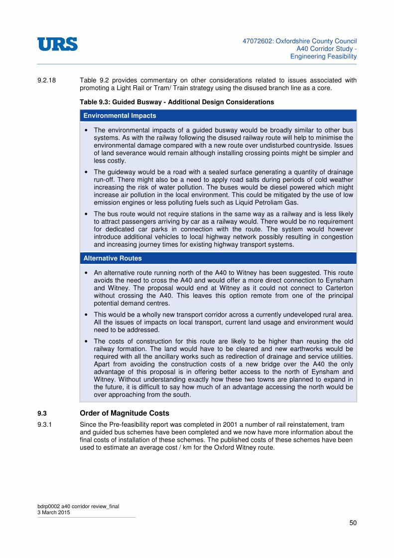
47072602: Oxfordshire County Council
A40 Corridor Study -Engineering Feasibility
bdrp0002 a40 corridor review_final 3 March 2015
50
9.2.18 Table 9.2 provides commentary on other considerations related to issues associated with promoting a Light Rail or Tram/ Train strategy using the disused branch line as a core.
Table 9.3: Guided Busway - Additional Design Considerations
Environmental Impacts
• The environmental impacts of a guided busway would be broadly similar to other bus systems. As with the railway following the disused railway route will help to minimise the environmental damage compared with a new route over undisturbed countryside. Issues of land severance would remain although installing crossing points might be simpler and less costly.
• The guideway would be a road with a sealed surface generating a quantity of drainage run-off. There might also be a need to apply road salts during periods of cold weather increasing the risk of water pollution. The buses would be diesel powered which might increase air pollution in the local environment. This could be mitigated by the use of low emission engines or less polluting fuels such as Liquid Petroliam Gas.
• The bus route would not require stations in the same way as a railway and is less likely to attract passengers arriving by car as a railway would. There would be no requirement for dedicated car parks in connection with the route. The system would however introduce additional vehicles to local highway network possibly resulting in congestion and increasing journey times for existing highway transport systems.
Alternative Routes
• An alternative route running north of the A40 to Witney has been suggested. This route avoids the need to cross the A40 and would offer a more direct connection to Eynsham and Witney. The proposal would end at Witney as it could not connect to Carterton without crossing the A40. This leaves this option remote from one of the principal potential demand centres.
• This would be a wholly new transport corridor across a currently undeveloped rural area. All the issues of impacts on local transport, current land usage and environment would need to be addressed.
• The costs of construction for this route are likely to be higher than reusing the old railway formation. The land would have to be cleared and new earthworks would be required with all the ancillary works such as redirection of drainage and service utilities. Apart from avoiding the construction costs of a new bridge over the A40 the only advantage of this proposal is in offering better access to the north of Eynsham and Witney. Without understanding exactly how these two towns are planned to expand in the future, it is difficult to say how much of an advantage accessing the north would be over approaching from the south.
9.3 Order of Magnitude Costs
9.3.1 Since the Pre-feasibility report was completed in 2001 a number of rail reinstatement, tram and guided bus schemes have been completed and we now have more information about the final costs of installation of these schemes. The published costs of these schemes have been used to estimate an average cost / km for the Oxford Witney route.
47072602: Oxfordshire County Council
A40 Corridor Study -Engineering Feasibility
bdrp0002 a40 corridor review_final 3 March 2015
51
9.3.2 It should be noted that this is not a detailed feasibility study and the estimates provided are therefore only indicative of the likely investment required. A cost/ km figure will be a crude measure as no two schemes are going to be exactly comparable as they are all made up of a combination of elements influences by specific and local factors. Some routes cross more challenging topography and will require far more earthworks; others, particularly in urban environments, have far more bridges crossing their routes.
9.3.3 These estimates do not include the cost of land acquisition and any cost associated with mitigation measures. The total land take for the scheme and the cost of that land cannot be estimated accurately at this stage.
9.3.4 A high level review of resent schemes and their costs has been used to establish an order of magnitude cost for the various scheme options proposed for the West Oxfordshire route. Some of these schemes are described below as examples.
9.4 Recent Rail Reinstatement Projects
Borders Rail Reinstatement Project
9.4.1 This project was to reinstate heavy rail infrastructure between Edinburgh and Galashiels. The route is approximately 30 miles (48.2km) in length and consists of a single track railway with 3 passing loops and 6 new stations along the route.
9.4.2 The railway passes through the hilly boarder country of the Scottish lowlands. There are a 100 bridge structures on the route including a 23 span viaduct. All of these structures required some repairs or in some cases replacement. Much of the route had remained undisturbed since the closure of the railway so relatively few properties had to be acquired for demolition.
9.4.3 The total cost of the scheme was £294million; equating to >£6.1m/ km
Stratford – Honeybourne Branch
9.4.4 This is a proposed project is for the reinstatement of the rail link between Stratford on Avon and Honeybourne Junction on the north Cotswold line. The northern end of the route will be through the centre of Stratford on a route that has been redeveloped with a roadway and cycle path. The remaining length is in relatively open countryside on a disused railway formation to Morton in the Marsh where a section of freight railway remains. The proposed route would require 9.6km of reinstatement and 4.8km of enhancement of the existing freight only rail section.
9.4.5 Cost estimate for the scheme is between £75 and £100million which is equivalent to an overall cost of between £5.2 and £6.9m/ km
Order of Magnitude Cost
9.4.6 These examples and other projects undertaken or under consideration has provided a range of costs for reinstatement of ‘Heavy’ gauge railways. Allowing for the impact of particular factors impacting the costs of individual projects an Order of Magnitude cost for reinstating the Oxford Witney route has been estimated. This is based on a professional judgment and not a detailed technical proposal assessment. A figure of £6.2 million/ km of route is suggested for the reinstatement of a single line railway.
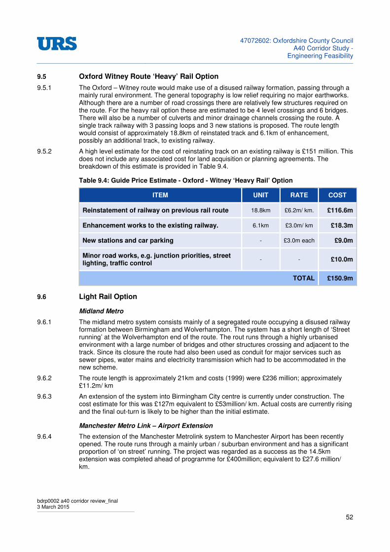
47072602: Oxfordshire County Council
A40 Corridor Study -Engineering Feasibility
bdrp0002 a40 corridor review_final 3 March 2015
52
9.5 Oxford Witney Route ‘Heavy’ Rail Option
9.5.1 The Oxford – Witney route would make use of a disused railway formation, passing through a mainly rural environment. The general topography is low relief requiring no major earthworks. Although there are a number of road crossings there are relatively few structures required on the route. For the heavy rail option these are estimated to be 4 level crossings and 6 bridges. There will also be a number of culverts and minor drainage channels crossing the route. A single track railway with 3 passing loops and 3 new stations is proposed. The route length would consist of approximately 18.8km of reinstated track and 6.1km of enhancement, possibly an additional track, to existing railway.
9.5.2 A high level estimate for the cost of reinstating track on an existing railway is £151 million. This does not include any associated cost for land acquisition or planning agreements. The breakdown of this estimate is provided in Table 9.4.
Table 9.4: Guide Price Estimate - Oxford - Witney ‘Heavy Rail’ Option
ITEM UNIT RATE COST
Reinstatement of railway on previous rail route 18.8km £6.2m/ km. £116.6m
Enhancement works to the existing railway. 6.1km £3.0m/ km £18.3m
New stations and car parking - £3.0m each £9.0m
Minor road works, e.g. junction priorities, street lighting, traffic control
- - £10.0m
TOTAL £150.9m
9.6 Light Rail Option
Midland Metro
9.6.1 The midland metro system consists mainly of a segregated route occupying a disused railway formation between Birmingham and Wolverhampton. The system has a short length of ‘Street running’ at the Wolverhampton end of the route. The rout runs through a highly urbanised environment with a large number of bridges and other structures crossing and adjacent to the track. Since its closure the route had also been used as conduit for major services such as sewer pipes, water mains and electricity transmission which had to be accommodated in the new scheme.
9.6.2 The route length is approximately 21km and costs (1999) were £236 million; approximately £11.2m/ km
9.6.3 An extension of the system into Birmingham City centre is currently under construction. The cost estimate for this was £127m equivalent to £53million/ km. Actual costs are currently rising and the final out-turn is likely to be higher than the initial estimate.
Manchester Metro Link – Airport Extension
9.6.4 The extension of the Manchester Metrolink system to Manchester Airport has been recently opened. The route runs through a mainly urban / suburban environment and has a significant proportion of ‘on street’ running. The project was regarded as a success as the 14.5km extension was completed ahead of programme for £400million; equivalent to £27.6 million/ km.

47072602: Oxfordshire County Council
A40 Corridor Study -Engineering Feasibility
bdrp0002 a40 corridor review_final 3 March 2015
53
Dublin LUAS
9.6.5 While not in the UK the Irish Republic maintains some similarities in the approach to the development of these projects and the technical issues faced. For example the Dublin light rail system also made use of disused railway corridors for its initial development.
9.6.6 A 4.2km extension to the ‘Red’ route A1 to City West was opened in 2012. The majority of this section is on segregated route over land previously earmarked as a potential transport corridor. The total cost was approximately £120 million; equivalent to £26 million/ km.
Order of Magnitude Cost
9.6.7 These examples and other projects undertaken have provided a range of costs for light rail projects. It is understood that there is a considerable difference between the cost of a system based on a disused railway formation and that of a new ‘on street’ system. The cost of constructing a tram line on a disused formation is likely to be similar to that for a heavy rail system. The requirements to repair and replace structures will be similar. The benefit gained from the ability of light rail to cope with diversions (curvature and gradient) must be offset against the additional cost of electrification. Stops on the tram route will be more numerous but less costly individually. A figure of £6.2m / km has again been used for the section of route on the disused railway formation.
9.6.8 Tram systems have significant differences between the cost of installing a segregated section of route and a shared ‘Street running’ section. On street operations attract a much higher cost. The impact on the street environment, existing buildings and buried services represents a major cost. A very wide variation in this cost can be seen between different projects completed in recent years. A figure of £30 million/ km is proposed for the purposes of this assessment.
Oxford Witney Route Light Rail Option
9.6.9 The disused railway has no existing gradients or curves where the technical capabilities of the tram would be of advantage. However there may be some benefit in reducing the cost of local diversions. The only significant one of these is to the south of Witney where unlike the heavy rail option the route may be diverted into the town itself.
9.6.10 A high level estimate for the cost for installing a tram route on the disused railway is between £129 and £207 million. This does not include costs of land acquisition or planning agreements. The breakdown of this estimate is provided in Table 9.5.
Table 9.5: Guide Price Estimate - Oxford - Witney ‘Light Rail’ Option
ITEM UNIT RATE COST
Installing Tram route on the disused rail route 18.8km £6.2m / km £116.6m
New station stops and car parking - - £2.0m
Minor road works, e.g. junction priorities, street lighting, traffic control
- - £10.0m
SUB TOTAL £128.6m
If additional sections of Street running are considered:
Eynsham 1.0km £30m / km £30.0m
Witney 1.6km £30m / km £48.0m
POSSIBLE TOTAL COST £206.6m

47072602: Oxfordshire County Council
A40 Corridor Study -Engineering Feasibility
bdrp0002 a40 corridor review_final 3 March 2015
54
9.6.11 Other sections of street running might also have to be considered in connecting to Oxford city centre. With the cost of bridging over the railway and major roads the final cost of the system could easily be double to above figure.
9.7 Guided Busway
9.7.1 Although a number of schemes are now proposed only one comparable guided bus system has been completed in the UK in recent years and that is the Cambridge Guided Bus Scheme.
Cambridge Guided Bus
9.7.2 The Cambridge Guided Busway is now the longest guided busway in the world and was opened in August 2011. The system uses a disused railway formation for much of its 26km length. The busway consists of two guideways 2.6m wide with a 0.8m wide central reservation. There is also a narrow access track adjacent to the guideway to provide access for maintenance and recoveries and a 0.7m wide emergency evacuation strip on the opposite side. In some locations a single guideway has been installed allowing a much narrower footprint for the system.
9.7.3 The total cost of the scheme was £181 million equating to approximately £7 million / km. This is for a system the majority of which has two parallel guideways. It is possible that costs could be reduced if a single guideway with passing points was installed.
Oxford – Witney Guided Busway
9.7.4 The guided bus has the advantage in that it can leave its segregated section of route and join the public highway when required attracting only minimal additional costs in terms of infrastructure. The system would make use of the disused railway formation for much of its length but will access towns along the route by existing roads. There has been some development on the formation of the old railway for which route diversions will be required. The overall length of guideway required has been estimated at 12.5km.
9.7.5 A high level estimate for the cost for installing a guided bus route on the disused railway is between £129 and £207 million. This does not include costs of land acquisition or planning agreements. The breakdown of this estimate is provided in Table 9.6.
Table 9.6: Guide Price Estimate - Oxford - Witney ‘Guided Busway’ Option
ITEM UNIT RATE COST
Installing guideways on disused Oxford-Witney rail route
12.5km £7m / km. £87.5m
New stops and car parking - - £1.0m
Minor road works, e.g. junction priorities, street lighting, traffic control
- - £2.0m
TOTAL £90.5m
If additional segregated sections of guideway are required to access the City, significant extra costs in terms of bridges and additional route length will be incurred. A nominal allowance of £50 million is suggested.
POSSIBLE TOTAL COST £140.0m
47072602: Oxfordshire County Council
A40 Corridor Study -Engineering Feasibility
bdrp0002 a40 corridor review_final 3 March 2015
55
10 CONCLUSIONS
10.1.1 The fundamental aim of this study is to identify options for reliving traffic congestion on the A40 corridor West of Oxford and improve access to the city from the West Oxfordshire area. It is also to look at longer term options, up to 2031, which may address the forecast growth in transport demand in this area.
10.2 A40 Highway Options
10.2.1 The A40 corridor currently caters for some 11,500 to just over 12,000 vehicles per day in the eastbound direction and a similar profile westbound. The road displays a dominant inbound (eastbound) flow towards Oxford which has a distinct peak (07:00 - 08:00hrs) at over 1,000 vehicles. Westbound flows have a relatively small morning peak (08:00-09:00hrs) that gradually builds towards a peak at 16:00hrs of 900 vehicles per hour with a secondary peak commencing 19:00hrs at 750 vehicles per hour. Combined two-way flows are relatively stable at between 1,400 and 1,700 vehicles per hour. 07:00 - 18:00hrs.
10.2.2 Current flows currently exceed those that would normally be expected for a WS2- Wide Single Carriageway road (i.e. a road with a nominal width of 10.0m) and are well above that indicated for a two lane S2 - Single Carriageway, which is a characteristic of the A40 study route.
10.2.3 Overall the evidence confirms that congestion and associated queuing is a regular feature of the route across a significant part of the day and in particular during the morning and evening peak hours. Not only is this likely to prove frustrating for general through and more local commuter traffic, it is also highly disruptive to local public transport services seeking to maintain a regular schedule for journeys to and from the City. Overall there is firm evidence to support the relatively long-standing aspirations for revisions and a sustainable alternative route strategy for the A40.
10.2.4 To achieve this objective a range of additional cross-sectional elements covering bus lanes, guided bus and the possibilities for tramways was applied to the corridor as a primary focus, although widening to provide additional general traffic was also considered.
Constraints Mapping
10.2.5 A constraints mapping exercise has identified a number of sections where the provision of even the minimum width guided busway, bus lane or additional traffic lane was likely to breach the existing public highway boundary or require revisions to it. In a number of situations, while the proposed lanes could fit within the boundary, the presence of structures spanning roads, railway or water courses would require a set back or revision that could demand additional land to support construction. Without acquiring additional highway land, this would impact on the overall route continuity if an uninterrupted facility is the optimum objective.
10.2.6 It was agreed with Officers of Oxfordshire County Council that a guided busway, a tram system tram and the promotion of a full dual carriageway or tidal flow regime faced too many obstacles to make these options attractive at this time. Widening to provide a parallel bus lane was however considered viable and should take the lead with focus on the most congested section of the route. This involved a section some 5.5km (3.36 miles) long section stretching between the A40/ B4449 roundabout at Eynsham and the area neighbouring Kingsbridge Brook; which lies some 0.65km (0.4 miles) west of the A34 Wolvercote Bridge. It was recognised that public transport benefits along this stretch of the A40 would complement the proposed capacity improvements surrounding Wolvercote roundabout further east.
10.2.7 In principle the study has shown that it would be practicable to provide a bus lane over most of this section of the A40. Obstacles to a continuous route do exist and these ‘pinch-points’ relate to:
• The traffic signals at the A40/ Eynsham Road/ Cassington Road staggered junction where there will be a need to provide a controlled route through the intersection for buses
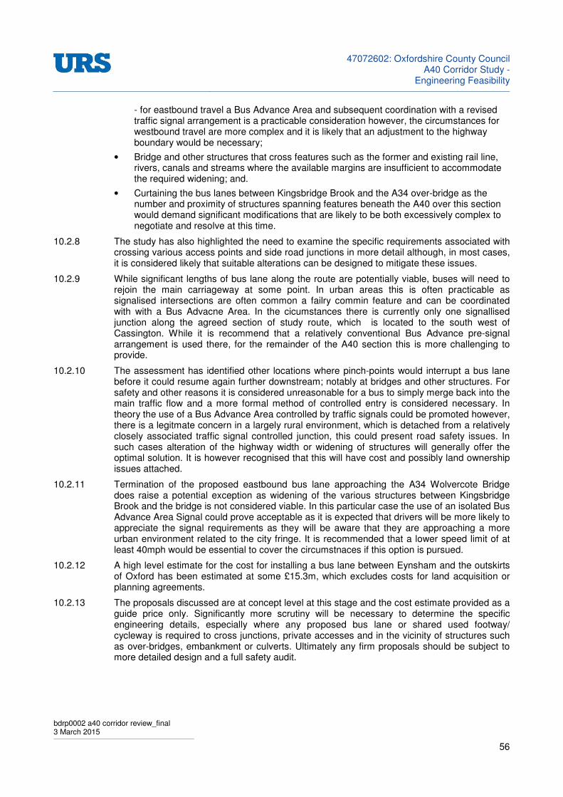
47072602: Oxfordshire County Council
A40 Corridor Study -Engineering Feasibility
bdrp0002 a40 corridor review_final 3 March 2015
56
- for eastbound travel a Bus Advance Area and subsequent coordination with a revised traffic signal arrangement is a practicable consideration however, the circumstances for westbound travel are more complex and it is likely that an adjustment to the highway boundary would be necessary;
• Bridge and other structures that cross features such as the former and existing rail line, rivers, canals and streams where the available margins are insufficient to accommodate the required widening; and.
• Curtaining the bus lanes between Kingsbridge Brook and the A34 over-bridge as the number and proximity of structures spanning features beneath the A40 over this section would demand significant modifications that are likely to be both excessively complex to negotiate and resolve at this time.
10.2.8 The study has also highlighted the need to examine the specific requirements associated with crossing various access points and side road junctions in more detail although, in most cases, it is considered likely that suitable alterations can be designed to mitigate these issues.
10.2.9 While significant lengths of bus lane along the route are potentially viable, buses will need to rejoin the main carriageway at some point. In urban areas this is often practicable as signalised intersections are often common a failry commin feature and can be coordinated with with a Bus Advacne Area. In the cicumstances there is currently only one signallised junction along the agreed section of study route, which is located to the south west of Cassington. While it is recommend that a relatively conventional Bus Advance pre-signal arrangement is used there, for the remainder of the A40 section this is more challenging to provide.
10.2.10 The assessment has identified other locations where pinch-points would interrupt a bus lane before it could resume again further downstream; notably at bridges and other structures. For safety and other reasons it is considered unreasonable for a bus to simply merge back into the main traffic flow and a more formal method of controlled entry is considered necessary. In theory the use of a Bus Advance Area controlled by traffic signals could be promoted however, there is a legitmate concern in a largely rural environment, which is detached from a relatively closely associated traffic signal controlled junction, this could present road safety issues. In such cases alteration of the highway width or widening of structures will generally offer the optimal solution. It is however recognised that this will have cost and possibly land ownership issues attached.
10.2.11 Termination of the proposed eastbound bus lane approaching the A34 Wolvercote Bridge does raise a potential exception as widening of the various structures between Kingsbridge Brook and the bridge is not considered viable. In this particular case the use of an isolated Bus Advance Area Signal could prove acceptable as it is expected that drivers will be more likely to appreciate the signal requirements as they will be aware that they are approaching a more urban environment related to the city fringe. It is recommended that a lower speed limit of at least 40mph would be essential to cover the circumstnaces if this option is pursued.
10.2.12 A high level estimate for the cost for installing a bus lane between Eynsham and the outskirts of Oxford has been estimated at some £15.3m, which excludes costs for land acquisition or planning agreements.
10.2.13 The proposals discussed are at concept level at this stage and the cost estimate provided as a guide price only. Significantly more scrutiny will be necessary to determine the specific engineering details, especially where any proposed bus lane or shared used footway/ cycleway is required to cross junctions, private accesses and in the vicinity of structures such as over-bridges, embankment or culverts. Ultimately any firm proposals should be subject to more detailed design and a full safety audit.

47072602: Oxfordshire County Council
A40 Corridor Study -Engineering Feasibility
bdrp0002 a40 corridor review_final 3 March 2015
57
10.3 Swinford Bridge
10.3.1 The route between the A40 and Oxford via the B4449 via Swinford Bridge is a relatively popular one for commuters and local buses. The opportunity to install a bus lane to avoid congested sections on the southbound approach to the bridge has been examined to reveal that it would be constrained by a number of obstacles, stretching alongside almost the entire length of the B4404 from Wharf Stream to the River Thames to include a long stretch of steep bank running immediately alongside the assumed highway boundary.
10.3.2 While auto-tolling and capacity improvements could reduce delay at the bridge, there remains the risk that this could simply encourage more general traffic to use the route; encouraging travel along roads that may be considered undesirable to support even larger volumes of commuter traffic. Previous studies to model the impact of improved throughput have indicated that this would be the case with demand anticipated to rise in the event that delay associated with the bridge is enhanced.
10.3.3 While the constraints review on the southbound approach to the toll bridge has suggested that installation of a bus lane would be technically feasible it would require fairly extensive land purchase and substantial earth works to deliver. The likelihood is that that the benefits could be far outweighed by the potential costs, making such a scheme difficult to justify. More detailed site investigation and benefits analysis would be required to confirm this.
10.4 Focus of the Rail Industry
10.4.1 The rail industry is acutely aware of the constraints to their infrastructure in this area and its impacts on the wider system. Schemes aimed at increasing capacity and reducing journey times are already underway with further work planned over the foreseeable future. All of these proposals are based on enhancements to the existing infrastructure. There are no proposals for opening new routes such as the Oxford to Witney line or rail connections to Abingdon. Network Rail and the Train Operating Companies have expressed little interest in reinstating the Witney branch route which does not feature in of their strategy proposals.
10.5 Alternative Options
Short Term Options
10.5.1 In dealing with the specific issue of traffic congestion on the A40 west of Oxford there are few obvious rail based options which could be delivered within the time frame and for the limited budget available.
10.5.2 The only short term option identified that might have some impact on traffic flows in this area would be through enhancements to Hanborough Station. The train operating companies intend to improve services from this station and Network Rail has identified options for infrastructure enhancements on the North Cotswold route. Passenger access is currently one of the major constraints deterring travellers from using this station. Improved car parking facilities, road access and access for bus services would make a major contribution to the development of Hanborough.
10.5.3 It is doubtful that this scheme alone will make a major impact on alleviating traffic congestion on the A40 although it could make a more significant contribution as part of the overall transport offer.
Longer Term Solutions
10.5.4 Rail, both light and ‘heavy’, could make an impact on travel patterns in the West Oxfordshire area however, these options all require major capital investment. The projected growth in population in the West Oxfordshire area will feed demand for local and intercity travel and may ultimately justify this investment.

47072602: Oxfordshire County Council
A40 Corridor Study -Engineering Feasibility
bdrp0002 a40 corridor review_final 3 March 2015
58
10.5.5 These schemes will undoubtedly make some impact on alleviating traffic congestion on the A40 and will contribute to the overall transport offering in the area. An improved transport link will act as an attractor to development encouraging population growth in the towns along its route.
‘Heavy’ Rail
10.5.6 A number of options were considered in the earlier Pre-Feasibility study that discounted the ‘Heavy’ rail option on grounds of cost and impacts. . The projected demand and operational cost need to be balanced with the capital cost in building a business case for any such an investment. Whilst the capital cost of this option may be the highest it is unlikely to be so much higher than the other rail based options as to make it unworthy of consideration. Reinstatement of the branch line through Witney to Carterton should remain to be considered as a possible option.
10.5.7 A high level estimate for the cost of reinstating track along the former rail line is £151 million noting that this figure excludes any associated cost for land acquisition or planning agreements.
Light Rail
10.5.8 Light rail introduces the possibility of street running in both the outlying towns and possibly into the centre of Oxford and beyond. The infrastructure costs of ‘Street running’ are several orders of magnitude higher than installation on a disused rail line. The clear benefits of tram operation need to be balanced against this cost.
10.5.9 The Tram/Train option allows infrastructure to be shared with Network Rail. This reduces the capital cost of installing the system and allows integration with the wider railway network. The tram/train only makes sense if it is intended to introduce a tram system into the City of Oxford. Outside of the city following the disused rail formation it offers no significant benefit over a ‘Heavy rail’ option. If a tram system is to be built then the impact of constraining a portion of it to running on Network Rail infrastructure needs to be understood. It may be that this additional high frequency tram traffic cannot be practically integrated with lower frequency higher speed National rail operating patterns.
10.5.10 A high level estimate for the cost for installing a tram route on the disused railway is between £129 and £207 million and once again this figure excludes costs for land acquisition or planning agreements.
Use of Former Rail Line for Guided Bus
10.5.11 The guided bus option offers more operational flexibility. The system would allow fast tracking of bus services to and from central Oxford. Mile for mile the cost of the guideway would be similar to the cost of a railway but the busway would not have a dedicated guide track throughout its entire route length. Buses can access and exit the guideway and move onto public roads where services are required. Using the old railway formation allows a new dedicated route removing traffic from congested roads and offering a faster and hopefully more reliable transport option.
10.5.12 The guideway however, is the most significant cost of the system and following the old railway would take the bus to places where it doesn't necessarily want to go. Enhancements to the existing local road network and possibly a bus lane on the A40 might be possible for a similar investment and may offer a better overall outcome.
10.5.13 It is envisaged that the busway would either join the A40 where it enters Hanson’s quarry with a dedicated bus lane or guided lane adjacent to the existing carriageway or new roads would need to be constructed linking the old railway with Oxford city centre and/or Water Eaton. Bridge works would be required to cross the existing railway lines.

47072602: Oxfordshire County Council
A40 Corridor Study -Engineering Feasibility
bdrp0002 a40 corridor review_final 3 March 2015
59
10.5.14 The busway could run alongside the Cotswold line railway however, the train operating company, First Great western, is proposing doubling this section of track and there would be limited space available on Network Rail land. Additional land would be required adjacent to the main Oxford – Banbury line. The railway master plan for the Oxford station area leaves little space on the western side for a bus route. Significant bridgeworks may still be required to allow a new bus route into the city.
10.5.15 A high level estimate for the cost for installing a guided busway on the disused railway is between £129 and £207 million. In common with the above this figure does not include costs for land acquisition or planning agreements and, depending on the route, there is likely to be additional cost should substantial new structures be required over features such as the existing railway.
10.6 Recommendations/ Opinions related to promotion of Rail
10.6.1 In the short term the most appealing way forward would be to support the proposed enhancements to Hanborough Station with relatively minor road works aimed at improving access. However the benefit in removing traffic congestion on the A40 is likely to be very limited.
10.6.2 In the longer terms the guided bus and heavy rail options appear to be the most practical. The busway has potential for lower investment cost and greater flexibility in accessing towns in the area. Heavy rail would be a consideration if there is significant projected demand. A rail branch could handle much greater passenger volumes and would attract additional usage from the wider area.
10.6.3 Light rail would only be a preferred option if Oxfordshire is planning an extensive tram network for Oxford and the surrounding area. The Tram/Train offers few attractions for this route as there is only a limited section where the system could operate on shared infrastructure and this is unlikely to justify the additional investment cost over a separated tram system.

47072602: Oxfordshire County Council
A40 Corridor Study -Engineering Feasibility
BDRP0002 A40 CORRIDOR REVIEW_FINAL 3 March 2015
APPENDIX A: Cross-Section Elements
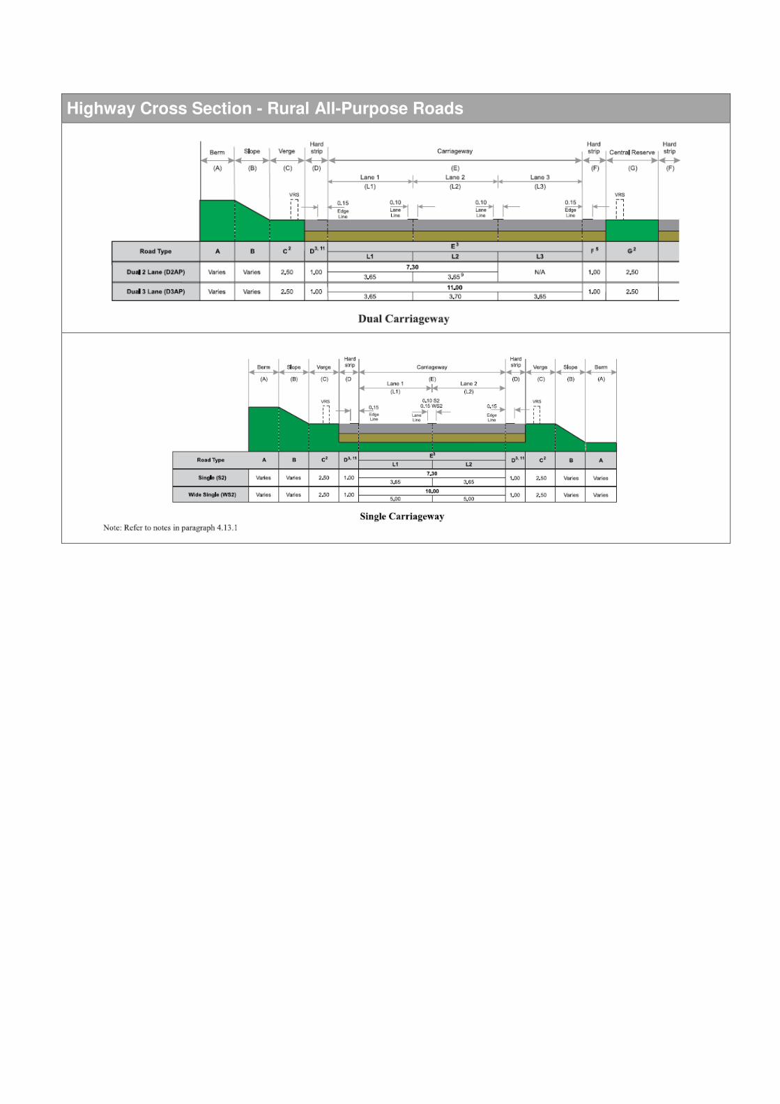
Highway Cross Section - Rural All-Purpose Roads

On Carriageway Busway: Cross-Sections
8.25m
6.00m
7.00m
8.00m
Guided Busway: Cross-Sections
9.00m
4.60m + Verge
7.60m
6.60m

Tram Cross-Section Requirements

47072602: Oxfordshire County Council
A40 Corridor Study -Engineering Feasibility
BDRP0002 A40 CORRIDOR REVIEW_FINAL 3 March 2015
APPENDIX B: Constraints Mapping
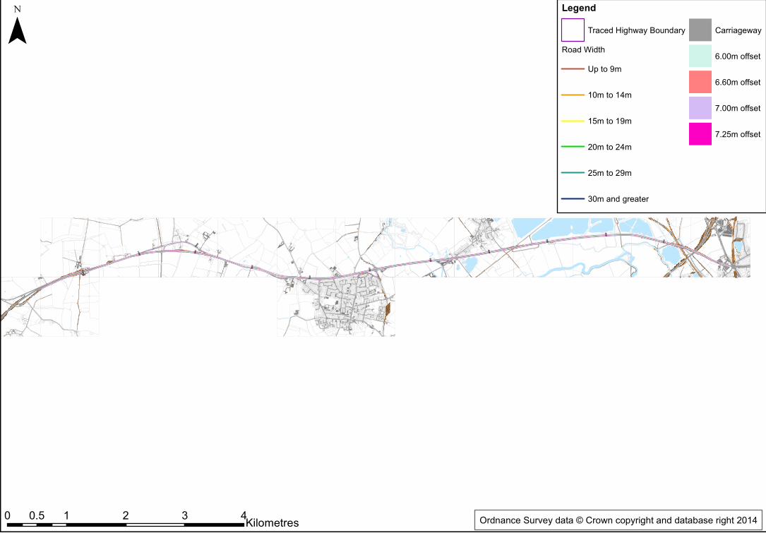
1200
1
800
900
100
1100
200
400
500
600
300
700
1000
¯
0 1 2 3 40.5 Kilometres
LegendTraced Highway Boundary
Road WidthUp to 9m
10m to 14m
15m to 19m
20m to 24m
25m to 29m
30m and greater
Carriageway
6.00m offset
6.60m offset
7.00m offset
7.25m offset
Ordnance Survey data © Crown copyright and database right 2014
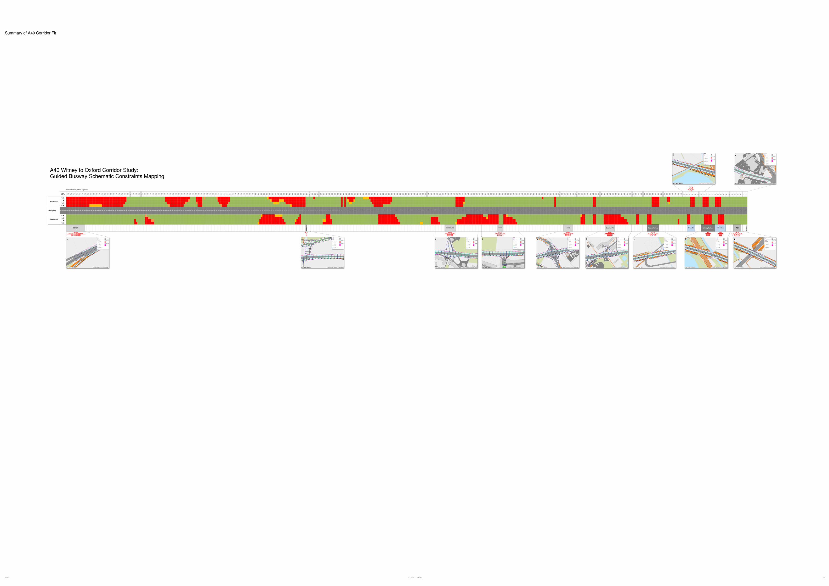
Summary of A40 Corridor Fit
Section Number (10 Metre Segments)
Option
Width (m) 1,2
80
1,2
79
1,2
78
1,2
77
1,2
76
1,2
75
1,2
74
1,2
73
1,2
72
1,2
71
1,2
70
1,2
69
1,2
68
1,2
67
1,2
66
1,2
65
1,2
64
1,2
63
1,2
62
1,2
61
1,2
60
1,2
59
1,2
58
1,2
57
1,2
56
1,2
55
1,2
54
1,2
53
1,2
52
1,2
51
1,2
50
1,2
49
1,2
48
1,2
47
1,2
46
1,2
45
1,2
44
1,2
43
1,2
42
1,2
41
1,2
40
to
1,1
94
1,1
93
1,1
92
1,1
91
1,1
90
1,1
89
to
1,1
68
1,1
67
1,1
66
1,1
65
1,1
64
1,1
63
1,1
62
1,1
61
1,1
60
1,1
59
1,1
58
1,1
57
1,1
56
1,1
55
1,1
54
1,1
53
1,1
52
1,1
51
1,1
50
1,1
49
1,1
48
1,1
47
1,1
46
1,1
45
1,1
44
1,1
43
1,1
42
1,1
41
1,1
40
1,1
39
1,1
38
1,1
37
1,1
36
1,1
35
1,1
34
1,1
33
1,1
32
1,1
31
1,1
30
1,1
29
1,1
28
1,1
27
1,1
26
1,1
25
1,1
24
1,1
23
1,1
22
1,1
21
1,1
20
1,1
19
1,1
18
1,1
17
1,1
16
1,1
15
1,1
14
1,1
13
1,1
12
1,1
11
1,1
10
1,1
09
1,1
08
1,1
07
1,1
06
1,1
05
1,1
04
1,1
03
1,1
02
1,1
01
1,1
00
1,0
99
1,0
98
1,0
97
98
9
98
8
98
7
98
6
98
5
98
4
98
3
98
2
98
1
98
0
97
9
97
8
97
7
97
6
97
5
97
4
97
3
97
2
97
1
97
0
96
9
96
8
96
7
96
6
96
5
96
4
96
3
96
2
96
1
96
0
95
9
95
8
95
7
95
6
95
5
95
4
to 91
1
91
0
90
9
90
8
90
7
to 87
9
87
8
87
7
87
6
87
5
87
4
87
3
87
2
87
1
87
0
86
9
86
8
86
7
86
6
86
5
86
4
86
3
86
2
86
1
86
0
85
9
85
8
85
7
85
6
85
5
85
4
85
3
85
2
85
1
85
0
84
9
84
8
84
7
84
6
84
5
84
4
84
3
84
2
84
1
84
0
83
9
83
8
83
7
83
6
83
5
83
4
83
3
83
2
83
1
83
0
82
9
82
8
82
7
82
6
82
5
82
4
82
3
82
2
82
1
82
0
81
9
81
8
81
7
81
6
81
5
81
4
81
3
81
2
81
1
to 73
4
73
3
73
2
73
1
73
0
72
9
72
8
72
7
72
6
72
5
72
4
72
3
72
2
72
1
72
0
71
9
71
8
71
7
71
6
71
5
71
4
71
3
71
2
71
1
71
0
70
9
70
8
70
7
70
6
70
5
70
4
70
3
70
2
70
1
70
0
69
9
69
8
69
7
69
6
69
5
69
4
69
3
69
2
69
1
69
0
68
9
68
8
68
7
68
6
68
5
68
4
68
3
68
2
68
1
68
0
67
9
67
8
67
7
67
6
67
5
67
4
67
3
67
2
67
1
67
0
66
9
66
8
66
7
66
6
66
5
66
4
66
3
66
2
66
1
66
0
65
9
65
8
65
7
65
6
65
5
65
4
65
3
65
2
65
1
65
0
to 59
9
59
8
59
7
59
6
59
5
59
4
59
3
59
2
59
1
59
0
to 57
9
57
8
57
7
57
6
57
5
57
4
57
3
to 49
6
49
5
49
4
49
3
49
2
49
1
to 46
3
46
2
46
1
46
0
45
9
45
8
45
7
45
6
45
5
45
4
45
3
45
2
45
1
45
0
44
9
44
8
44
7
44
6
44
5
44
4
to 38
0
37
9
37
8
37
7
37
6
37
5
to 36
4
36
3
36
2
36
1
36
0
35
9
35
8
35
7
35
6
35
5
35
4
35
3
to 33
3
33
2
33
1
33
0
32
9
32
8
to 11
8
11
7
11
6
11
5
11
4
to 95
94
93
92
91
90
89
88
87 to 78
77
76
75
74
73
72
71
70
69
68
67
66
65
64
63
62
61
60 to 52
51
50
49
48
47
46
45 3 2 1
7.25
7.00
6.60
6.00
Carriageway
6.00
6.60
7.00
7.25
BA
NA
RD
GA
TE
WO
LV
ER
CO
TE
Existing Railway Oxford CanalDuke's Cut A34Eynsham Rd Disused RailwayCUCKOO LANEWITNEY
Eastbound
Westbound
B449WITNEY RD
A40 Witney to Oxford Corridor Study: Guided Busway Schematic Constraints Mapping
09/01/2015 Corridor Width Assessment 150105_MA 1 of 1
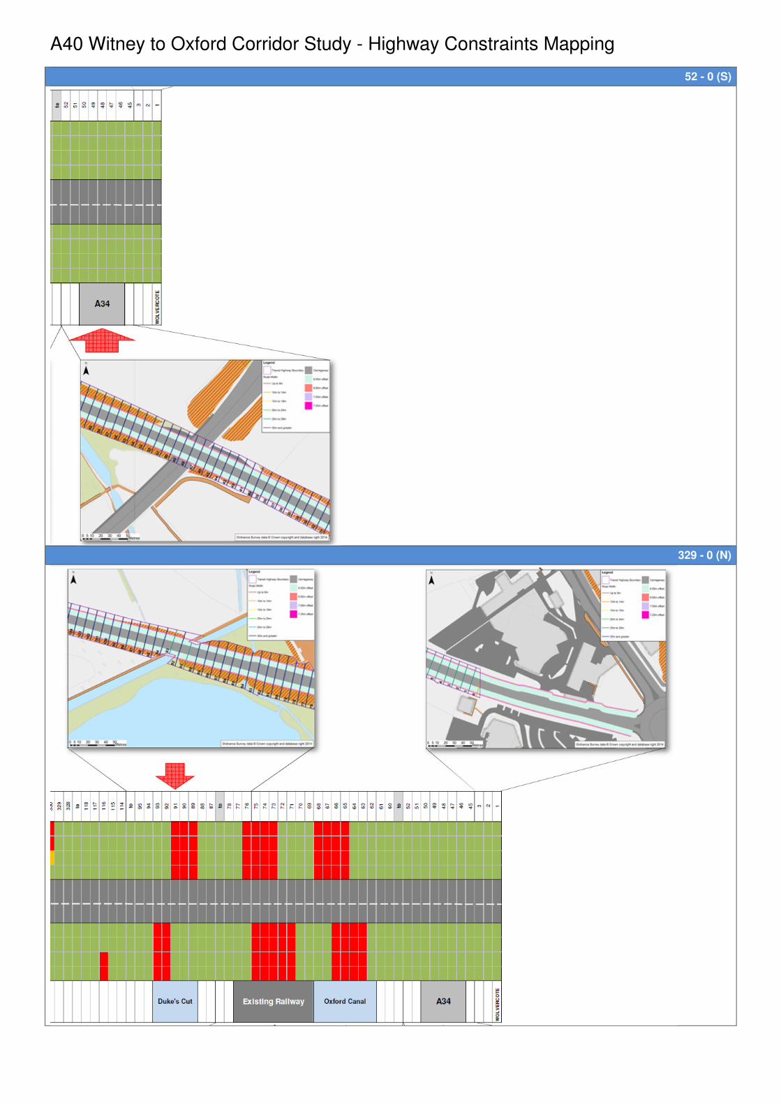
A40 Witney to Oxford Corridor Study - Highway Constraints Mapping
52 - 0 (S)
329 - 0 (N)
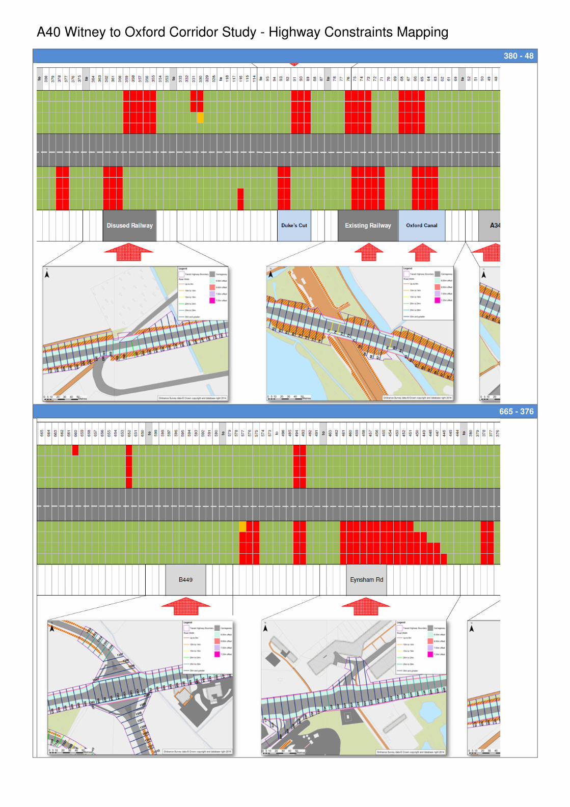
A40 Witney to Oxford Corridor Study - Highway Constraints Mapping
380 - 48
665 - 376
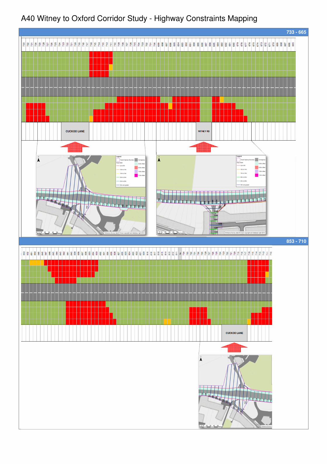
A40 Witney to Oxford Corridor Study - Highway Constraints Mapping
733 - 665
853 - 710
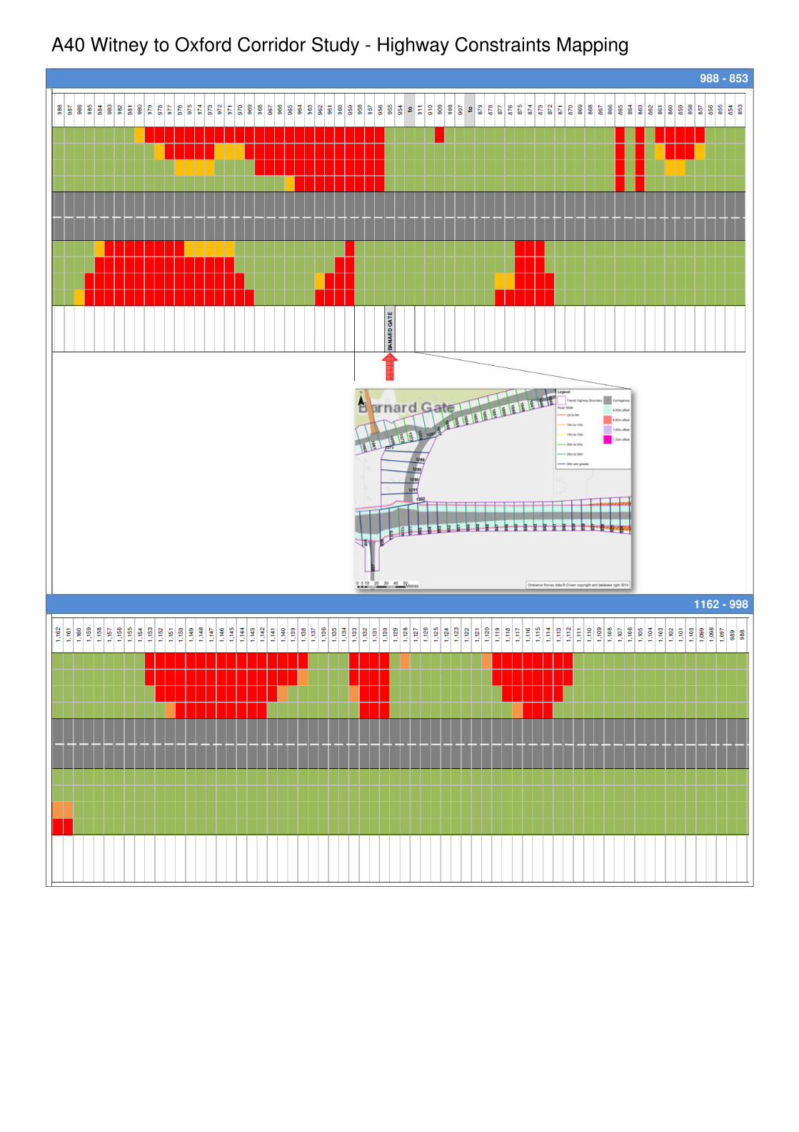
A40 Witney to Oxford Corridor Study - Highway Constraints Mapping
988 - 853
1162 - 998

A40 Witney to Oxford Corridor Study - Highway Constraints Mapping
1,162 - 1,280
47072602: Oxfordshire County Council
A40 Corridor Study -Engineering Feasibility
BDRP0002 A40 CORRIDOR REVIEW_FINAL 3 March 2015
APPENDIX C: Schematic Concept Drawings
Agreed Option Section- A40/ B4449 Eynsham to Kingsbridge Brook
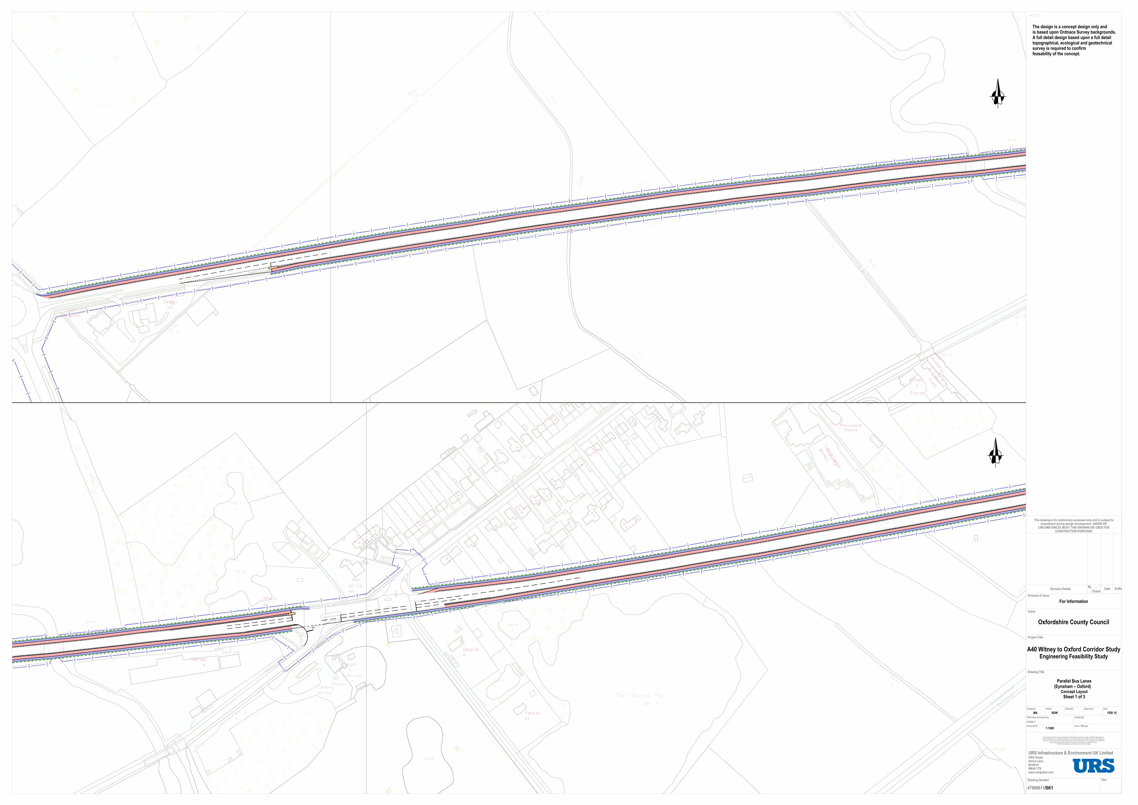
For Information
MA SDW FEB 15
/SK1
Parallel Bus Lanes(Eynsham – Oxford) �
Concept Layout
Sheet 1 of 3
1:1000
This drawing is for preliminary purposes only and is subject toamendment during design development. UNDER NO
CIRCUMSTANCES MUST THIS DRAWING BE USED FORCONSTRUCTION PURPOSES
Oxfordshire County Council
47066811
47066811
A40 Witney to Oxford Corridor StudyEngineering Feasibility Study
Drawing Number Rev
DateApprovedCheckedDrawn
URS Internal Project No.
Drawing Title
Project Title
Client
Suitability
Scale @ A0 Zone / Mileage
URS Infrastructure & Environment UK Limited
Purpose of issue
URS HouseHorne LaneBedfordMK40 1TSwww.ursglobal.com
Designed
This document has been prepared in accordance with the scope of URS' appointment with its client and is subject to the terms of that appointment. URS accepts no liability for any use of this document other than by its client and only for the purposes for which it
was prepared and provided. Only written dimensions shall be used. © URS Infrastructure & Environment UK Limited
SuffixBy
Revision Details DateCheck
The design is a concept design only andis based upon Ordnace Survey backgrounds.A full detail design based upon a full detailtopographical, ecological and geotechnicalsurvey is required to confirm feasability of the concept.

For Information
MA SDW FEB 15
/SK2
Parallel Bus Lanes(Eynsham – Oxford) �
Concept Layout
Sheet 2 of 3
1:1000
This drawing is for preliminary purposes only and is subject toamendment during design development. UNDER NO
CIRCUMSTANCES MUST THIS DRAWING BE USED FORCONSTRUCTION PURPOSES
Oxfordshire County Council
47066811
47066811
A40 Witney to Oxford Corridor StudyEngineering Feasibility Study
Drawing Number Rev
DateApprovedCheckedDrawn
URS Internal Project No.
Drawing Title
Project Title
Client
Suitability
Scale @ A0 Zone / Mileage
URS Infrastructure & Environment UK Limited
Purpose of issue
URS HouseHorne LaneBedfordMK40 1TSwww.ursglobal.com
Designed
This document has been prepared in accordance with the scope of URS' appointment with its client and is subject to the terms of that appointment. URS accepts no liability for any use of this document other than by its client and only for the purposes for which it
was prepared and provided. Only written dimensions shall be used. © URS Infrastructure & Environment UK Limited
SuffixBy
Revision Details DateCheck
The design is a concept design only andis based upon Ordnace Survey backgrounds.A full detail design based upon a full detailtopographical, ecological and geotechnicalsurvey is required to confirm feasability of the concept.

For Information
MA SDW FEB 15
/SK3
Parallel Bus Lanes(Eynsham – Oxford) �
Concept Layout
Sheet 3 of 3
1:1000
This drawing is for preliminary purposes only and is subject toamendment during design development. UNDER NO
CIRCUMSTANCES MUST THIS DRAWING BE USED FORCONSTRUCTION PURPOSES
Oxfordshire County Council
47066811
47066811
A40 Witney to Oxford Corridor StudyEngineering Feasibility Study
Drawing Number Rev
DateApprovedCheckedDrawn
URS Internal Project No.
Drawing Title
Project Title
Client
Suitability
Scale @ A0 Zone / Mileage
URS Infrastructure & Environment UK Limited
Purpose of issue
URS HouseHorne LaneBedfordMK40 1TSwww.ursglobal.com
Designed
This document has been prepared in accordance with the scope of URS' appointment with its client and is subject to the terms of that appointment. URS accepts no liability for any use of this document other than by its client and only for the purposes for which it
was prepared and provided. Only written dimensions shall be used. © URS Infrastructure & Environment UK Limited
SuffixBy
Revision Details DateCheck
The design is a concept design only andis based upon Ordnace Survey backgrounds.A full detail design based upon a full detailtopographical, ecological and geotechnicalsurvey is required to confirm feasability of the concept.