a45 daventry development link road due for completion … · · 2018-01-24we will continue to...
TRANSCRIPT
Northamptonshire HighwaysA45 Daventry Development Link RoadDue for completion spring/summer 2018Newsletter 6 - January 2018
Welcome to the sixth edition of the Daventry Development Link Road Newsletter. Happy New Year and we hope you had a good Christmas.
Our first newsletter was issued in Spring 2016, and since then we have issued newsletters at fairly regular intervals. We want this newsletter – and subsequent issues – to keep you informed.
We would also welcome your views and comments so that we can make sure we are giving you the information you really want.
We will continue to build-up a ‘Frequently Asked Question’ (FAQ) section on the Northamptonshire County Council (NCC) website. If you are unsure about anything or want to know more please ask us. This will help to form the FAQ section on the NCC website and help to keep the information we provide to you relevant and accurate.
This newsletter is produced by the delivery team for the project who are Northamptonshire Highways and Balfour Beatty Construction Services UK who are now well into the programme to build the new A45 Daventry Development Link Road.
We will continue to issue these newsletters as we progress to keep residents, affected land owners, local businesses and other interested groups informed about our work and the way we will carry it out.
Simon LevellSite liaison manager
Rebecca MillerCommunication
The scheme
The main works contract for the A45 Daventry Development Link Road has now been running for almost 18 months, and during this time considerable progress has been made on most aspects forming part of the overall scheme. Following the advance works (Phase 1 contract), which began early in 2016, entailing initial site clearance of vegetation, trees, hedges etc and establishment of boundary fencing – Balfour Beatty Civil Engineering were awarded the main works (Phase 2 contract) for the new road in July 2016. The progress on site can be summarised as follows:
Earthworks
Major progress has been made with the critical bulk earthworks operation which is now largely complete across much of the site. This includes excavation for cuttings, some of it in hard ground, to the north of Flore and the operation of placing this excavated fill material to form major embankments north of Weedon, including those leading up to the key railway and canal crossing near Dodford, the river crossing of the Whilton Brook north of Weedon and a new raised alignment for the A5 trunk road. Significant excavation has taken place to form cuttings in the vicinity of the Hillside Road bridleway, Brockhall Road and Brington Road areas immediately north of Flore.
Progress has also been very good on excavation to the east of Flore towards Upper Heyford and the building of embankments around the Hollandstone Brook watercourse between the two villages. Further east, near M1 Junction 16, work is now well-advanced on the bulk earthworks for the proposed eastern termination roundabout and associated connecting tie-ins to existing roads and accesses.
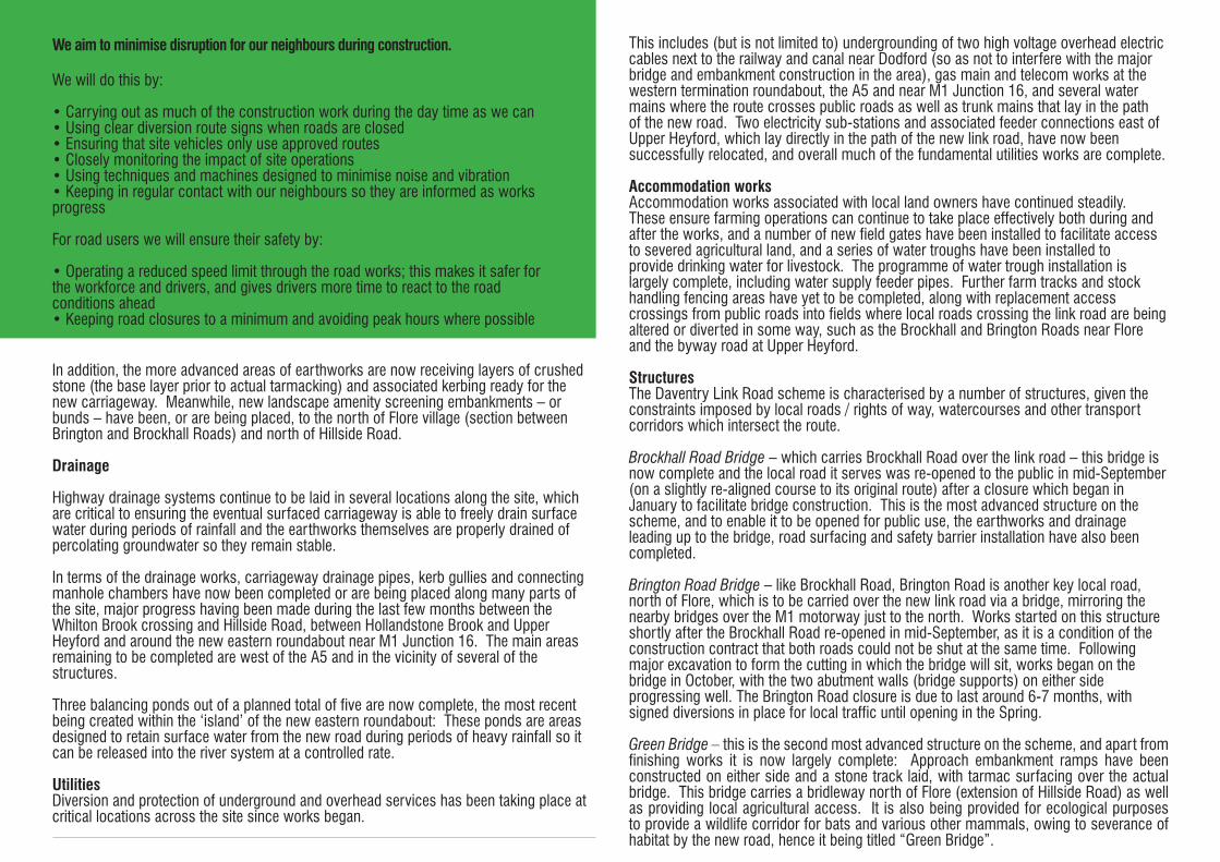
In addition, the more advanced areas of earthworks are now receiving layers of crushed stone (the base layer prior to actual tarmacking) and associated kerbing ready for the new carriageway. Meanwhile, new landscape amenity screening embankments – or bunds – have been, or are being placed, to the north of Flore village (section between Brington and Brockhall Roads) and north of Hillside Road.
Drainage
Highway drainage systems continue to be laid in several locations along the site, which are critical to ensuring the eventual surfaced carriageway is able to freely drain surface water during periods of rainfall and the earthworks themselves are properly drained of percolating groundwater so they remain stable.
In terms of the drainage works, carriageway drainage pipes, kerb gullies and connecting manhole chambers have now been completed or are being placed along many parts of the site, major progress having been made during the last few months between the Whilton Brook crossing and Hillside Road, between Hollandstone Brook and Upper Heyford and around the new eastern roundabout near M1 Junction 16. The main areas remaining to be completed are west of the A5 and in the vicinity of several of the structures.
Three balancing ponds out of a planned total of five are now complete, the most recent being created within the ‘island’ of the new eastern roundabout: These ponds are areas designed to retain surface water from the new road during periods of heavy rainfall so it can be released into the river system at a controlled rate.
UtilitiesDiversion and protection of underground and overhead services has been taking place at critical locations across the site since works began.
This includes (but is not limited to) undergrounding of two high voltage overhead electric cables next to the railway and canal near Dodford (so as not to interfere with the major bridge and embankment construction in the area), gas main and telecom works at the western termination roundabout, the A5 and near M1 Junction 16, and several water mains where the route crosses public roads as well as trunk mains that lay in the path of the new road. Two electricity sub-stations and associated feeder connections east of Upper Heyford, which lay directly in the path of the new link road, have now been successfully relocated, and overall much of the fundamental utilities works are complete.
Accommodation worksAccommodation works associated with local land owners have continued steadily. These ensure farming operations can continue to take place effectively both during and after the works, and a number of new field gates have been installed to facilitate access to severed agricultural land, and a series of water troughs have been installed to provide drinking water for livestock. The programme of water trough installation is largely complete, including water supply feeder pipes. Further farm tracks and stock handling fencing areas have yet to be completed, along with replacement access crossings from public roads into fields where local roads crossing the link road are being altered or diverted in some way, such as the Brockhall and Brington Roads near Flore and the byway road at Upper Heyford.
StructuresThe Daventry Link Road scheme is characterised by a number of structures, given the constraints imposed by local roads / rights of way, watercourses and other transport corridors which intersect the route.
Brockhall Road Bridge – which carries Brockhall Road over the link road – this bridge is now complete and the local road it serves was re-opened to the public in mid-September (on a slightly re-aligned course to its original route) after a closure which began in January to facilitate bridge construction. This is the most advanced structure on the scheme, and to enable it to be opened for public use, the earthworks and drainage leading up to the bridge, road surfacing and safety barrier installation have also been completed.
Brington Road Bridge – like Brockhall Road, Brington Road is another key local road, north of Flore, which is to be carried over the new link road via a bridge, mirroring the nearby bridges over the M1 motorway just to the north. Works started on this structure shortly after the Brockhall Road re-opened in mid-September, as it is a condition of the construction contract that both roads could not be shut at the same time. Following major excavation to form the cutting in which the bridge will sit, works began on the bridge in October, with the two abutment walls (bridge supports) on either side progressing well. The Brington Road closure is due to last around 6-7 months, with signed diversions in place for local traffic until opening in the Spring.
Green Bridge – this is the second most advanced structure on the scheme, and apart from finishing works it is now largely complete: Approach embankment ramps have been constructed on either side and a stone track laid, with tarmac surfacing over the actual bridge. This bridge carries a bridleway north of Flore (extension of Hillside Road) as well as providing local agricultural access. It is also being provided for ecological purposes to provide a wildlife corridor for bats and various other mammals, owing to severance of habitat by the new road, hence it being titled “Green Bridge”.
We aim to minimise disruption for our neighbours during construction.
We will do this by:
• Carrying out as much of the construction work during the day time as we can• Using clear diversion route signs when roads are closed• Ensuring that site vehicles only use approved routes• Closely monitoring the impact of site operations• Using techniques and machines designed to minimise noise and vibration• Keeping in regular contact with our neighbours so they are informed as works progress
For road users we will ensure their safety by:
• Operating a reduced speed limit through the road works; this makes it safer for the workforce and drivers, and gives drivers more time to react to the road conditions ahead • Keeping road closures to a minimum and avoiding peak hours where possible
Upper Heyford Bridge – This farm access bridge at Upper Heyford is well advanced, the beams have been placed and the reinforced concrete deck completed, along with the aluminium parapets along both sides of the span. Whilst there is still some more work to do, when complete the bridge will provide continuity of the local byway road as well as providing essential agricultural access.
Whilton Brook Bridge - A key bridge over a tributary of the River Nene is also progressing well. The Whilton Brook Bridge has a particularly large span to meet criteria associated with minimising the effect on the flood plain. Following placing of eight precast concrete beams in the Summer, works continued to complete the bridge deck and parapets during the Autumn, and the most recent works have been concrete wing walls (extensions of the bridge approaches) on either side of the river.
Hollandstone Farm Culverts – These structures have now started and are progressing well. Over the last couple of months, there have been two visits to site by a large mobile crane to lift first a series of precast box units to span the Hollandstone Brook watercourse (midway between Flore and Upper Heyford) and subsequently a number of even larger precast concrete sections to form a farm access subway under the link road embankment. There is a further structure yet to be built in this area, and several associated works in and around the culverts to take place before they are fit-for-purpose.
Dodmoor Rail & Canal Bridge – Last but not least is the critical and largest structure on the entire scheme – the Dodmoor Rail & Canal Bridge. This major two-span bridge will eventually carry the link road over the West Coast Main Line Railway and Grand Union Canal. All piling works are now complete on both sides of the bridge and in the centre, and the focus of construction has now switched to building the massive abutment walls to support the embankments on both the canal and railway approaches, columns to support the bridge beams, and notably a central pier (intermediate support) for the bridge literally ‘sandwiched’ between the railway and canal. Major construction challenges lay ahead for this bridge as a whole – including overnight operations at weekends when Network Rail temporarily closes the railway to allow works to proceed.
A5 Trunk Road:Another major milestone was met in November, with the re-opening of the A5 trunk road, north of Weedon, following its reconstruction at a higher level than originally to intercept the new link road via a roundabout. This has enabled the closure of the temporary diversion road just to the west which has been in use for about a year, the removal of which is necessary to complete critical earthworks and drainage works, the major bridge over the canal/railway, and reinstate land that has been rented from adjacent land owners.
SummaryOverall, the scheme is progressing well, although the shorter daylight hours of Autumn into Winter, coupled with recent challenging weather associated with heavy snowfall and freezing conditions has created significant challenges for construction activities in recent weeks.
Community Liaison & Communications: Throughout these works, close liaison continues to be maintained with the local land owners, in order to ensure that their farming operations are not compromised or otherwise delayed in relation to the construction operation. Close and amicable relationships are also being maintained with local residents, businesses, parish councils and statutory bodies, collectively ensuring that the works can co-exist whilst minimising disruption and community-related issues.
In this latter respect, a Community Stakeholder Working Group has been set-up, and has already met on a number of occasions to discuss issues relating to the impact of the scheme on the local community, and to address issues before they become problems. Furthermore, Balfour Beatty have registered the project with the Considerate Constructors Scheme, a nationally-recognised initiative which rewards contractors and projects based on being good neighbours with the local residential, business and road-using communities with whom they have to co-exist. Balfour Beatty have contributed to several community initiatives in both Weedon and Flore, whilst links with local schools in terms of safety awareness and careers ideas bring a further community dimension.
This quarterly Newsletter continues to be issued to those who wish to sign-up to the e-mailing distribution list.
For more information about the scheme you can visit the website at www.northamptonshire.gov.uk
Please advise people that they can join this mailing list and receive regular progress updates by emailing [email protected] and registering their email address. They will be added to the mailing list and this information will remain confidential and will not be shared with any third parties.
If you have any questions relating to these activities please do not hesitate to contact Simon Levell at [email protected] who will be your site-based contact on day-to-day issues specifically relating to the road construction phase and its impacts.
For all general highway issues that are not specific to the Daventry Development Link Road works you should contact the Street Doctor service in Northamptonshire.
Remember, you can also report highway faults online too at northamptonshire.gov.uk/streetdoctor
Follow us on Twitter @nnhighways for all the latest transport and highways updates and news.
A45 Daventry Development Link Road funded by:Northamptonshire County Council, SEMLEP and
Daventry District Council

BM 73.07m 72.8m
Track
Path (um)
River Nene
SewageWorks
Posts
77.2m
79.7m
FB
73.7m
HILLSI
DE CRES
CENT
THEP
EA
K
HILLSIDE ROAD
BUGBROOKE ROAD75.5m
WA
KE
FIE
LD W
AY
73.7m
BM 76.66m
The Green
The Pound
GP
HeyfordCottage
BlissCharity Aided
School
BM 75.50mPARSONS CL
Posts TheOld Sun
(PH) WA
TER
Y L
AN
E
BROOKSIDE PLACE
Path
Allotment Gardens
Issues
PumpHouse
BridgeLodge
MANOR PARK
Sinks
MAN
OR
WAL
K
FB
615
3
12
14
2
46
2
12
22
1
9
1115
1721
23
19
17
11
9
1
2
3
4
5
31
81016
2
8
10
14
16
25
15
15
9
5a5
3
1a
1
6
1
35
91115
12
34
5
4
1417
1511
1
12
20
212
24
26a
26
38
52
1
11
15
29
41
36
22
38
40
2
16
2
2
2a4
4a
6
8
2
12
16
1
11 15
27
2
14
24
25
1115
1
BM 76.60m
5
Issue
s
14
12
MID
DLE
STR
EET
7
8
36
24
1816
5143
FB
30
25
21
Tennis
Tennis
Court
Court
Pavilion
Sports Field
12a
11
14a
Orchard
Pond
Issues
Benns
12
3a
10d
10a
10b
10c
8
27
Track
Track
Pond
Track
El Sub Sta
A 45
MAIN ROAD
210
16
TCBLB
Fir Lea
Foxwood
Park View
River
River NeneFoot Bridge
Pump
Path (um)
Pat
h (u
m)
Pond
Pond
9 5 3 1
Hill Farm
WhiteGates
Upper Heyford
1115
The Close
Hipwells
House
81.3m
81.3m
82.2m
88.6m
88.8m
81.8m
77.3m
79.5m
83.1m
71.9m
72.1m
BM 84.67m
BM 81.50m
BM 88.21m
BM 72.50m
Nene
M 1
A 45
82.2m
8
80.3m
77.2m
Tk
Ebenezer House
DovecoteFarm
HomeFarm
Pond
TheBarn
The Stables
Coach House
Path (u
m)
Track
135.0m
Track
122.5m
Track
140.8m
PillarBM 141.45m
Flag Staff
Glassthorpehill
Pond
M 1
83.8m
Issues
Spring
BM
118.99m
122.5m
Track
Track
Drain
93.9m
89.6m
Spring
BM 93.40m
FB
FBFB
Targets
Track
New Covert
Lower Glassthorpe
93.9m
Spring
BM 95.01m
Pond
Pond
Track
BM 97.91m
97.2m
97.2m
FB
100.3m
107.0m
Pond
118.9m
127.4m
Flagstaff
Trac
k
Vicarage Farm DW
99.1m
Pond
Pond
Drain
2
TITHE
RO
AD
50
52
56
6064
68
67
67b
FernhollowFarm
GP
59
57
102.4m
55
47
Upper Weedon
112.5m
126.6m
Issues
132.4m
Reservoir(covered)
139.2m
151.7m
154.0m
152.3m
GP
BM 154.37m Weedon Hill Farm
Spring
Spring
Weedon Hill
148.0m
141.9m
Hillcrest Cottage
Track
BM 138.74m
FARTHINGSTONE ROAD 134.8m
122.8m
110.3m
BM 106.69m
102.9m
97.1m
NE
W S
TRE
ET
4339
Spring59
17
15
The Old Priory
OAK STREET
35
12
7
OAKLANDS
1
37
41
19
21273139
Pit
104.9m
BM 105.04m
38102.6m
24
17
28 26
22
16
8
Builder'sYard
911
15
(disused)
QUEEN STREET
68
98.0m
49
58a58b
51
The Bungalow
PrioryCourt
1
425
Drain
Track
Pond
HO
LM C
LOS
E
2
8
15
16 18
11
FB
A 5
Issues
Spring
Lay-by
SL
Issues
Sand Pit
Landing Spinney
Skew Bridge
MP 70.75
GP
Pond
Gra
nd U
nion
Can
al
RO
MAN
RO
AD
SkewbridgeSpinney
Towing P
ath
Canal Low
er Belt
A 5
Watling Street
97.2m
92.0m
96.3m
99.1m
93.3m
86.9m
BM 87.02m
MP 71
MP 70.5
Drain
Guide Post
Def
Def CS
BM 123.01m
122.5m
A 45119.8m
MP .75
SL
Globe Farm
Pond
MP .25
82.0m
Grand
Unio
n Can
alMP 70
Dismantled Railway
BM 82.12m
GP82.3m
BM 82.02m
Foot Bridge
Stone
Stone
84.4m
A 5
MP 8
86.3m
BM 93.74m
Dodmoor Farm
SL
MP .25
98.5mBM 100.04m
BM 108.36m
109.4m104.5m
Reservoir
82.0m
Towing Path
Watling Street
ROM
AN ROAD
87.8m
Dodford WharfFarm
WeedonJunction
A 5
Dodmoor FarmBungalow
FB
Pond
Track
Track
Tanks
Drain
Dodmoor Farm Grounds
Track
TITHE R
OAD
Spring
Pond
129
4 2
17
PR
INC
ES
CLO
SE
22
2
16
10
6
14
QUEENSTREET
4
LB
TCB
BM98.75m
2
2414
1
71115
19
14
8
QUEEN'S PARK
2
126
17
1115
2120
12
2
42 1
511
15
25
CR
OFT W
AY
27
39
95.3m
2 4
12
20
28
36
23
1511a11
1
25
38
46
56
66
76
3749
86
78 100
92
59
NEW CROFT
69
81
BM 93.09m
132
Hillside
View
118110
146
156
134140
14
ST MARY'S WAY
11
111
MA
NO
RR
OA
D
1517
111
15
WAYPETER'SST
27
41
30
2822
CommunityCentre
Lower Weedon
6
41
10
15
71115
(Track)ORDNANCE ROAD
Dra
in
Tip(disused)
Depot
Issues
Pond
Water
Pond
Issues
22 168
NENESIDE CLOSE
Drain
2
103
91
89 85
75
71
67 65
63 59
WEST STREET43
41
37
33 15
9 3
1b 1a 1
Church
10
80.4m
20
Works
PH
222430
38
40
BM 80.99m80.6m
42
24 1
612
20
2
12
2
8
2115119
5448
TheBungalow
RiversideCourt
81.1m
16
1 4
86.0m
WB
Gantry
Water
Water
The Old Depot
Water
Pond
19
15
11 9 1 OrdnanceHouse
4
2
3 2
LITTLE PRIEL ROAD
25
28
31
GLOUCESTER
CLOSE 19
16
1514
12
10
5
1
1715
78
75
910
REGENCY CLOSE
32
38
44
13
23
1
4
6
York
Ride
2
10
16
2228
WINDSORCLOSE
HIGH STREET
Footbridge
97.1m
68
Bank
NewHouse
DodfordWharfFarm
BM91.55m
92.1m
WeedonJunction
103.1m
PoliceHouse
19
112.4m
119.2m117.9m
DUKELANDS
Tk
KINGS PARK
Recreation Ground
Chy
Station House
York Ride
43a
7
36
2
WAY
Weedon BecPrimary School
RIVERSIDE DRIVE
WA
Y
7
OA
K S
T
99.3m
ST
MA
RTY
N'S
91.5m
WES
T
83.6m
1819
17
TCB
38a
Hill
crof
t
BROOKSIDE
20122
Weedon Bec
3842
54525048
4644
56 58
36
32 30
26
20
24
1814 12
8 6
2
1
111517
2319
2521
27
33
2
LANCERS WAY
1
12
9
24
18
27
6
4240
38
36
34
1
37EQUESTRIAN WAY10
24
12
42
2022
1
5 6
10
THE G
REYS
12
14
1516
17
18
19
41
HARMANS WAY
45
47
53
BM 109.65m
14
BR
IDG
E S
TRE
ET
El Sub Sta
HARMANS WAY
25
20
Grand U
nion Canal
NE
W S
TRE
ET
River Nene
The
BRIDGE ST
11
1
8141818a20
24
14
26
28
15
30
16
Towing P
ath
A 45
Flats
Depot
Gas Governor
ElSubSta
Depot
GasGovernor
Depot
CAVALRY HILL
1
MagpieHouse
55
Surgery
60
70
13b 13a 11b 11a
5
21
12
13
2a
Mid
dle
Wel
l Ho
Allotment
Gardens
Upper Weedon
3
5
6
1617
5153
Path
1
23
BUSWELL
CLO
SE
14
10
18
9
1
8
2
CAMPBELL CLOSECAVALRY FIELDS
2
1218
2
1
3
5
770
78
75
77 79
14
1586 87
2
4
6
8
(Units 1 to 11)
StrawberryFields
1
715
25
35
4553
FUSILIER WAY
4a
The East Lodge
Track Porch
Track
Issues
75
DairyFarm
Spring
BM 162.32m
Pillar
158.5m
Spring
156.5mFern Hollow
Sinks
TheFirs
Upper Weedon
FARTHINGSTONE R
OAD
Weedon Hill
QUEEN STREET
70
House
72
7678
Cattle Grid
HomeFarm House
OR
DN
AN
CE
RO
AD
Tip
Track
Track
The Firs
Track
Sinks
(dis)
Track
Upper Weedon
MP 1
2
1
Willow End
97.8m
95.1m
GP95.4m
Honeymoon Cottage
118.6m
116.4m
Mile Stone
Stone
Grange Farm
122.5mGlobe Farm
A 45
OR
DN
AN
CE
RO
AD
The White House
Dra
in
Pond
Pond
GP
Wagoners Cottage
Track
Pond
90.3m
BM 90.69m
Sluice
Sewage Works
Towing Path
Grand Union Canal
SL
Pit(disused)
Trac
k
Foot Bridge
Foot Bridge
Track
MP .75
A 5
Towing Path
The Narrow Boat(PH)
LB
The Bungalow
97.4m
Spring
106.8m
SL
Lay-by
117.9m
Oaktreehill Barn
114.4m
Grand
Canal
Stowehill
Union
StowehillWharf
97.1m
RO
MAN
RO
AD
102.8m
BM 112.89m
Stowehill Tunnel
Tanborough
SL
MP 68
Mile Stone
WhiteHall
The Grange
StowehillCottage
Water
Water
Track
Path
Tank
Trac
k
Path (um
)
Pond
Issues
Spring
Chapmans Close
Greenacres
MP
85.5m
31
2321 19CHURCH LANE
2212
15 11 1
2
53 49
Hall
Heyford Lodge
MAN
OR
PAR
K
63
71
The Rectory
45
39
3533
73.9m
2216
19
25
2729
Cemetery
12
8
1
6
Denbrook
29
27
16
86
25
War Meml
30
1
9
11
15 74.1m
4
10
6
8
2
28
26
24 20 18
76.7mTCBGP
911
1a
1b
Halls
23
17
Grand Union Canal
Towing Path
ETL
29
39
41
14
72
60
48
42
27
43
25
29
33
4
2
15
HILLSIDE ROAD
1
35
39
Posts
CLO
SE R
OAD
10
23
15
11
WINSTON CLOSE
8
2
86
78
FURNACE LA
NE
59
71
1
81
36
28a
28
24
18
31
16
SOUTH VIEW19
1511
53
2
5557
WES
TERN
AVE
NUE
4
10
17
15
11
3
27
1
69
ROLF
E CR
ESCE
NT
30
2
6
RO
LFE
CR
ES
CE
NT
8
24
14
19
1715
11
1
2
6
12
Coal Yard
BurnhamCottage
41
39
18
22
29
WEEDON ROAD
Nether HeyfordBaptist Church
PH
Club
CH
UR
CH
STREET
7 6
The Green
7
24
83.4m
St Peter andSt Paul's Church
3
5
CHURCH STR
EET
PO
10
6
6
59
30
51
Greenacres
48
40
38
75
5541
16
22
36
28
47
26
24
ThePound
15
19
NetherHeyford
Pond
WhiteHouse
Hall
2
9
10
1214
15
16
17
ROBERTS FIELD
20
1
3
18
El Sub Sta
72a
88
21
28
Swingbridge House
Butterfields
Pond
Pond
Pond
Issues
98.1m
BM 98.86m
Tank
100.3m
BM 97.28m
96.3m
Sinks
93.3m
Pond
96.3m
Cattle Grid
92.4m
Pond
Vicarage Farm
94.5mBM 95.02m
Track
95.7m
Cloverlea
ETL
Track
Sinks
95.4m
TrackIssues
Sinks
Issues Sinks
Issues
Pond
Pond
Drain
Pond
Ponds
Pond
Track
M 1
92.0m
90.2m
ETL
88.7m
87.2m
A 45
84.7m 85.3m
BM 85.07mPond
77.1m
Spring
Hollandstone Farm
Hotel
Lay-by
Pond
Lay-by
Hollandstone Farm
Path
Path
Cottage
FB
Foot Bridge
Issues
ETL
Issues
Weir
FB
Heyford Mill
Simon's
A 45
Trac
k
81.8m
77.3m
Grand Union Canal
Issues
River Nene
Pond
Pond
Ponds
Trac
k
Track
Drain
Drain
Drain
Ponds
Path (um)
Flore House
THE AVENUE
Flore C of E Pond
Posts
Posts
54
Controlled
SPRIN
G LAN
E
School
48
46
76
SU
TTON
STR
EE
T
59
9 1115
NETHER LANE
Issues
NETHER LANE
43
Issues
Pond
Playing Field
Issues
Track
FBThe Mill Farm
Issues
Issues
Weir
Pond
Tow
ing
Pat
h
The Grange StowehillKingfishers
Issues
Grand
Ingledell
Union Canal
Whitehall
Whitehall Farm
Stanton's Barn
74
House
Cottage
Cottage
BR
ICK
ETTS
LAN
E
Foot Bridge
GP90.6m
All Saints' Church
High-house Wharf
BM 90.75m
OverflowSluice
90.2m
Pond
Brodie Lodge
35
42 4447
Stowehill Wharf
Little Nearton
FB
Spring
Langhley
Flore LaneWharf
61
Lake
Pond
Camping Site
Path (um)
Path (um)
Path
(um
)
Jetties
Trac
k
ElSubSta86.6m
36
30
1814
12 8
TheVicarage
Pine Reach
MP69
WharfHouse Weedon Wharf
Cemetery
Track
83.4m
Sewage Works
86.0m
Garage
BM79.77m
80.0m
82.4m
BM 82.37m
St Peter's Church
5654
46
40
3024
22
CH
UR
CH
STREET 39
312523
21a
21
82.5m19
WeedonU Ref Ch
NE
W S
TRE
ET25
29
3537
Club
5d 5a5
3 1
1715
PO
6a6
2
1715
5
46
GP80.2m
Plume ofFeathers
(PH)
3
Abattoir
1
24
8 12
1418
14a
Track
Allotment Gardens
Pump House
Path (um)
FB
BM 81.11m
Lay-by
80.2m
80.7mLay-by
80.8m
Garage
80.5m
ManorFarm
85.3m
83.4m
Grand Union Canal
River Nene
Brooklyn
TheFlats
6 3
BRIDGE STREET87.1m
BM 85.65m
FB Piers
MP
BoatYard
24
21
Depot
The Croft
BM82.59m
TCB
CrossroadsHotel Track
Flore Park
84.3m
TheLodge
FLORE HILL
85.7m
A 5W
ATLING
STREET
Works
Globe Hotel1723
25
Weedon House
29
PH
TelEx
The
6
66
40
PHPO
30
26
20
18
Trelawny
16
128
4
2
12
10
Towing Path
SOUTH STREET
9
75
31
36
1
Bungalows
1
90.1m
Watling Street
ROMAN ROAD
42
SL
Issues
29
Bollards
52
60
58
56
Water
BRIDGE STREET
A 5
HIGH STREET
Gas Gov
TennisCourt
Redlynch
10
12
21
ETONCLOSE
10
Works
1 to3
11
2
18
15 to21
23 to 33
35 to 45
40 to
48
36 38
28 to 34
20 to 26
3
5
2 12
4155
BILLINGSCHOOL PL
2
3a
7
1
2
TheHollies
47
1
66a
Red HouseWharf
1 to 6
Posts
1
Lake
Path (Um)
Flore House
THE AVENUE
Flore C of E Pond
Posts
Posts
54
Controlled
SPRIN
G LAN
E
School
48
46
76
SU
TTON
STR
EE
T
59
9 1115
NETHER LANE
Issues
NETHER LANE
43
Issues
Pond
Playing Field
Issues
Track
FBThe Mill Farm
Issues
Issues
Weir
Pond
Tow
ing
Pat
h
The Grange StowehillKingfishers
Issues
Grand
Ingledell
Union Canal
Whitehall
Whitehall Farm
Stanton's Barn
74
House
Cottage
Cottage
BR
ICK
ETTS
LAN
E
Foot Bridge
GP90.6m
All Saints' Church
High-house Wharf
BM 90.75m
OverflowSluice
90.2m
Pond
Brodie Lodge
35
42 4447
Stowehill Wharf
Little Nearton
FB
Spring
Langhley
Flore LaneWharf
61
Lake
Pond
Camping Site
Path (um)
Path (um)
Path
(um
)
Jetties
Trac
k
99.4m
Riding Stables
COLLINS HILL
BM104.94m
M 1
94.8m
97.2m
BM 99.02m93.3m
99.4m
M 1
101.8m
Pond
103.9m
THE CRESCENT
El Sub Sta
RO
AD
100.3m
100.6m
Shelter
93.6m
BM 94.24m
Garage
Police House
95.7m
CAPELL RISE
Pond
Pond
PondPond
El Sub Sta
Works
LB (PH)
Royal Oak
BM 100.79m
HIGH STREET
PO
LB
Memorial
White Hart(PH)
Hall
96.6m
BM 97.12m
94.2m
El Sub Sta
Pp
TCB
STR
EE
T
SUTT
ON
SUTTON ACRE
Russell R
ise
Surgery
BM 102.72m
FLORE HILL
102.1m
THE AVEN
UE
LAN
E
BRIC
KETT
S
SPRINGFIELD SP
RIN
GLA
NE
TennisCourt
THE GREEN
KIN
G'S
LAN
E
LilacCottage
The Lilacs
Pond
MeadowFarmTHE ORCHARD
LB
LAN
EC
HA
PE
L
Church
Greyleys
NETHER LANE
THO
RN
TON
CLO
SE
Ashley
House
Pond
Oaklands
Primary School
TheGlebe
GreenCountry
3
2
1
1511
1
2
4
12
2
12
2315
1514
12
6
1
11
5
1
3
24
44
37
29
1915
117
3
28 32
34
36
40
4446
48
10
12
14
3
24
30
42
56
66
72
55
19
1
6
12
23
47
39
31
29
27
25
4
1412
20
242
4
159
31
19
15
11
95
7
1a
23
21
19
1511
5
1
6
5052
56
56a
58
58a
60
62
2
4
6
810
1416
12
45
4135
2
8 34 32
11
1
23
11
7
1
64
68
72
2
10
1824
53
1
125
121
2
831
26
20
1412
6
1
10
20
32
29
15
2
12
22
2315 11
1
11
3
214
26
23 15 111
5349
43
25
3
1
BRO
CKH
ALL
BLI
SS
LA
NE
The
Firs
14
8
34
Conyngham
Pond House
The Vicarage
SE
AR
S C
LOS
E
19
1
7
14
12
1b
2a4
1
1
56
Track
60
10
8
GroveHouse
HighgroveHouse
13
FloreFarm
Flore
Ashlawn
Living Stones
119
MEADOWFARM
51
Nene View
CL
2a
2b
4
6
YEW TREE GARDENS
4
1
31
66a
27
Flore C of E
Rosea
FloreCott
25
17
44a46a
1a
41
MUSCOTT CL
28
13
76
812
41
1a
2
25a
16
2
Drain
Mast
103.9m
GP
BM 104.47m
Lodge
102.7m
M 1
Pond
101.8m
Issues
Issues
Issues
96.3m
98.1m
94.8m
BM 101.10m
Pond
Pond
Pond
95.4m
Pump
Pond
Oxhouse Farm
Pond
93.3m
BM 92.26m
Oxhouse Farm Cottages
Trac
k
Track
Dra
in
Drain
Dra
in
Collects
Willow
Ford
Track
Broamenthill Spinney
PTP
PTP
Posts
Whi
lton
Broo
k
Weir
Greenway Spinney
Brooks's Plantation M 1
Flore Fields Spinney
87.2m
89.6m
91.4m
HobhillSpinney
Pond
Drain
Drai
n
87.8m
BM87.79m
86.9m
Gas CylinderFilling Depot
The Bungalow 4
1 A 45
89.3m
96.9mCattle Grid
FLORE HILL
106.4m
BM 107.95m
106.1m
101.2m
A 45
LB
10
12
14
16
1
2
1115
17
14
22
Path
HILLS
IDE
RO
AD
Smallholding
Hobhill BarnPond
Track
Hobhill Spinney
Spring
Water Tower
2018
Flore Hill Farm
The
Bungalows
ElSubSta
Tel Ex
WATLING
STREET
ROM
AN ROAD
Drain
Drain
Hadland House
Hadland House Farm
Collinshill Farm
ElSubSta86.6m
36
30
1814
12 8
TheVicarage
Pine Reach
MP69
WharfHouse Weedon Wharf
Cemetery
Track
83.4m
Sewage Works
86.0m
Garage
BM79.77m
80.0m
82.4m
BM 82.37m
St Peter's Church
5654
46
40
3024
22
CH
UR
CH
STREET 39
312523
21a
21
82.5m19
WeedonU Ref Ch
NE
W S
TRE
ET25
29
3537
Club
5d 5a5
3 1
1715
PO
6a6
2
1715
5
46
GP80.2m
Plume ofFeathers
(PH)
3
Abattoir
1
24
8 12
1418
14a
Track
Allotment Gardens
Pump House
Path (um)
FB
BM 81.11m
Lay-by
80.2m
80.7mLay-by
80.8m
Garage
80.5m
ManorFarm
85.3m
83.4m
Grand Union Canal
River Nene
Brooklyn
TheFlats
6 3
BRIDGE STREET87.1m
BM 85.65m
FB Piers
MP
BoatYard
24
21
Depot
The Croft
BM82.59m
TCB
CrossroadsHotel
Road Weedon
Track
Flore Park
84.3m
TheLodge
FLORE HILL
85.7m
A 5W
ATLING
STREET
Works
Globe Hotel1723
25
Weedon House
29
PH
TelEx
The
6
66
40
PHPO
30
26
20
18
Trelawny
16
128
4
2
12
10
Towing Path
SOUTH STREET
9
75
31
36
1
Bungalows
1
90.1m
Watling Street
ROMAN ROAD
42
SL
Issues
29
Bollards
52
60
58
56
Water
BRIDGE STREET
A 5
HIGH STREET
Gas Gov
TennisCourt
Redlynch
10
12
21
ETONCLOSE
10
Works
1 to3
11
2
18
15 to21
23 to 33
35 to 45
40 to
48
36 38
28 to 34
20 to 26
3
5
2 12
4155
BILLINGSCHOOL PL
2
3a
7
1
2
TheHollies
47
1
66a
Red HouseWharf
1 to 6
Posts
1
Lake
Path (Um)
Spring
Spring
Spring
Pond
Track
Issues
Dundas Covert
Pond
Pond
Issues
Pond
108.5m
101.8m
95.7m
Def
Pond
Issues
Issues
Spring
Pond
Track
Pond
Trac
k
Pond
Pond
Spring
Issues
River Nene
75.3m
79.2m
79.2m
77.1m
77.6m
A 45
A 45
M 1
BM79.21m
Drain
A 5
Pond
KS19
EU18
EU18
EU15
EU15
EU7
EU7
EU9
EU7
EU6
KS14KS21
KS5
EU10
EU9
KS5
EU7
EU6
EU
5
EU5
EU2
EU
12
EU11
EU
12
EU1
FE1
FG1
FG1
FG11
FG11
EN9
EU1
EU
2
EU
14
EU
14
FG11
FG2
FG11
FG10
FG15
FG10
FG8
FG14
FG4
FG16
FG4
FG2
FG8FG9
FG3
FG18
FG16
FG5
FG5
FG13
KD12
KD14
KS8
KS6
KT6
KS2
KT1
KT2
KT3
KT6
KS7
KS16KS1
KS17
KS6
KS19
KS18
KT1
KS5
KS14
KS
3
KT4
KT5
KS5
KT4
KS10
KS10
KS5
KS11
KS11
KS12
EL
33kV
33kV
EL
EL
EL
EL
EL
11kV
11kV
11kV
11kV
11kV
EL
EL EL
EL
EL
EL
EL
Approximate Location ofProposed Office Blocks
Dodmoor Canaland Rail Bridge
Whilton BrookBridge
Brockhall RoadBridge
Brington RoadBridge
Green Bridge
HollandstoneFarm Culvert
Upper HeyfordFarm Bridge
HollandstoneFarm Crossing
Area of ArchaeologicalInterest
PET CEMETERY
Ch 0W
This map is reproduced from Ordnance Survey material withthe permission of Ordnance Survey on behalf of the Controllerof Her Majesty's Stationery Office © Crown copyright.Unauthorised reproduction infringes Crown copyright and maylead to prosecution or civil proceedings.
Northamptonshire County Council: Licence No. 100019331.Published 2014.
FOR INFORMATION ONLY
L:\G
RO
WTH
\HIG
HW
AY
DE
SIG
N\2
015-
16\A
45 D
AV
EN
TRY
DE
VE
LOP
ME
NT
LIN
K\A
UTO
CA
D\B
AS
E P
LAN
AN
D L
ON
G S
EC
TIO
NS
DW
G N
O 0
3I &
04I
.DW
GC
AD
File
:L:
\GR
OW
TH\H
IGH
WA
Y D
ES
IGN
\201
5-16
\A45
DA
VE
NTR
Y D
EV
ELO
PM
EN
T LI
NK
\AU
TOC
AD
\BA
SE
PLA
N A
ND
LO
NG
SE
CTI
ON
S D
WG
NO
03I
& 0
4I.D
WG
APDCHKDESCRIPTIONBYDATE
DRAWING STATUS:
REV
REV:
DATE:
CHECKED:
DESIGN/DRAWN:
DRAWING No:
PROJECT:
TITLE:
SCALE @ A0
PROJECT No:
APPROVED:
CA
D F
ile:
S1265 R1999/03
A45 Daventry Development Link
Base Plan
1/5000 MFH SL
SMT 29/01/14
I
29/01/14 SMTA Original MFH SLB 01/05/14 SMT Vertical Alignment Amended Ch1700 - Ch2600 MFH MHC 24/07/14 SMT Balancing Ponds Added MFH SL
Earthworks amended Ch1600 to Ch2500 MFH SLD 21/08/14 SMT A5 to A45 Link Route Amended
Rights of Way - Key
Existing Bridleway
Existing Footway
Diverted Footway
E 03/11/14 SMT A5 Roundabout and Carriageway Amended MFH SL
F 19/12/14 SMT Various Scheme Amendments MFH SL
G 10/03/15 SMT Access Tracks Removed. Green Bridge Widened MFH SL
H 29/04/15 SMT Access Tracks Amended. Other Minor Amendments MFH SL
I 01/09/15/ SMT Earthworks Amended Ch1500-Ch2500 MFH SL
The new road
FLORE
WEEDON
New A5Roundabout
The existing A45