a82 report template3.1.7 the basic peat characteristics are considered in appendix 10.1 (volume 2)....
TRANSCRIPT

A9 Dualling – Dalwhinnie to Crubenmore DMRB Stage 3 Environmental Impact Assessment
Appendix 10.2 Groundwater Dependent Terrestrial Ecosystems
A9 Dualling – Dalwhinnie to Crubenmore DMRB Stage 3 Environmental Impact Assessment
Contents
1 Introduction 1
2 Approach and Methods 1
3 Baseline Conditions 2
4 Potential Impacts 39
5 Conclusions 50
6 References 52
Tables Table 1: Potential GWDTE NVC Communities and Sub-Communities Identified 4 Table 2: Potential GWDTE NVC Community and Sub-Community Description and Distribution 5 Table 3: Potential GWDTE NVC Community and Sub-Community Details and Scoping 6 Table 4: Potential GWDTE Assessment of Likely Groundwater Dependence 16 Table 5: Potential GWDTE Impact Assessment 41 Table 6: Potential GWDTE Direct Loss and Temporary Disturbance 50
A9 Dualling – Dalwhinnie to Crubenmore DMRB Stage 3 Environmental Impact Assessment
Appendix 10.2 - Groundwater Dependent Terrestrial Ecosystems Page 1
1 Introduction
1.1.1 In support of Chapter 10 (Volume 1) of the Design Manual for Roads and Bridges (DMRB) Stage 3 Environmental Impact Assessment (EIA) report; this technical appendix presents the baseline details related to potential Groundwater Dependent Terrestrial Ecosystems (GWDTE) identified within the study area for Project 8 – Dalwhinnie to Crubenmore of the A9 Dualling Programme (hereafter referred to as the Proposed Scheme). GWDTE are types of wetland that are specifically protected under the Water Framework Directive (WFD, 2000/60/EC).
1.1.2 The purpose of the appendix is to identify ‘potential’ GWDTE based on National Vegetation Classification (NVC) habitat survey findings, further assess their ‘likely’ groundwater dependence based on their topographical, geological and hyrdo-ecological context, and assess potential impacts which may occur as a result of construction and operation of the Proposed Scheme.
1.1.3 The information presented supports the assessment of potential impacts in Chapter 10 (Volume 1) and has been prepared based on analysis of NVC habitat survey (MacArthur Green, 2015) findings presented in Appendix 12.3 (Volume 2). These aspects of the DMRB Stage 3 EIA should therefore also be referred to as necessary.
2 Approach and Methods
2.1.1 The assessment related to potential GWDTE covers a study area extending to at least 100m from the permanent and temporary works boundaries of the Proposed Scheme, which was extended further where required. In order to identify these, analysis of NVC Survey (MacArthur Green, 2015) findings was initially undertaken in accordance with Scottish Environment Protection Agency (SEPA) Land Use Planning System Guidance Note 31 (LUPS-GU31) ‘Guidance on Assessing the Impacts of Development Proposals on Groundwater Abstractions and GWDTE’ (SEPA, 2014a).
2.1.2 LUPS-GU31 states that assessment of potential GWDTE is required where these are situated within 100m of excavations less than 1.00m in depth, or within 250m of excavations greater than 1.00m in depth. Based on this, all potential GWDTE within 100m of the permanent and temporary works boundaries of the Proposed Scheme and areas within at least 250m of excavations identified in Table 10-13 in Chapter 10 (Volume 1) have been considered. Some areas were scoped out due to the presence of hydrological barriers such as the River Truim, Highland Mainline Railway (HML) or Scottish and Southern Energy (SSE) aqueduct. In these instances, it was considered unlikely that potential groundwater effects would impact the areas, combined with distance and intervening topography.
2.1.3 The likely groundwater dependency for those remaining potential GWDTE areas has been assessed through consideration of possible water supply mechanisms based on site observations, the local topography, underlying geology and the potential for surface water contributions to the habitats. Potential impacts on each area are then considered related to direct disturbance within the permanent works boundaries, temporary disturbance in the wider land made available (LMA) and estimated of zones of dewatering influence from areas likely to intercept groundwater using the empirical formula of Sichardt (Powers et al., 2007; CIRIA, 2016).
2.1.4 The sensitivity of potential GWDTE considered in the assessment is based on the criteria in Table 10-4 within Chapter 10 (Volume 1). As a result, these are discussed as having high, moderate or low ground-water dependency.
A9 Dualling – Dalwhinnie to Crubenmore DMRB Stage 3 Environmental Impact Assessment
Appendix 10.2 - Groundwater Dependent Terrestrial Ecosystems Page 2
3 Baseline Conditions
Geology
3.1.1 As shown in Drawing 10.1 (Volume 3), published BGS mapping indicates the superficial deposits within the study area to variably include made ground, peat, alluvium, alluvial fan deposits, river terrace deposits, glaciofluvial deposits, diamicton till and hummocky glacial deposits.
3.1.2 The solid geology throughout the majority of the study area comprises Precambrian Psammite of the Gaick Psammite Formation; recorded as predominantly quartzose psammite with scattered biotite flakes and laminae. BGS mapping also indicates the Loch Laggan Psammite and Falls of Phones Semipelite Formations in the north, as shown in Drawing 10.2 (Volume 3). These strata comprise micaceous and feldspathic psammite, and gneissose but locally schistose, respectively.
3.1.3 The folded metasedimentary units in the southern extents dip in various directions from southwest to northeast, with the angle of dip ranging from 15° to 85°. In northern extents towards Crubenmore, there is a dominant dip towards the south at angles between 20° and 76°. The folded units have formed several anticlinal and synclinal structures and the axis of a major synclinal fold runs along and immediately adjacent to the existing A9 between ch. 24,900 and ch. 30,400. Regionally, the Ericht-Laiden Fault also runs approximately parallel to the existing A9 in a northeast–southwest orientation. This appears to cross cut the road alignment to the north of the Proposed Scheme, while the Glen Truim fault runs approximately north-south approximately 750m west of the main carriageway near Crubenmore.
3.1.4 These conditions have broadly been substantiated by available ground investigation (GI) information, as described in Chapter 10 (Volume 1).
Soils
3.1.5 As illustrated in Drawing 10.4 and 10.5 (Volume 3), the majority of the study area is underlain by peaty gleyed and peaty podzols, with humus-iron podzols and peaty gleys with blanket peat and peaty podzols or rankers also present. The River Truim valley is underlain by mineral and peaty alluvial soils between ch. 24,300 and ch. 29,700, with humus-iron podzols and alluvial soils northward of these near Crubenmore. Dystrophic basin and valley peat is also present within, and adjacent to, the east of the Proposed Scheme between ch. 22,100 and 22,700 at Dalwhinnie, with peaty gleys including blanket peat and peaty podzols north and southward of this.
3.1.6 Peaty soils and topsoil (less than 0.50m thickness) have been encountered across the study area, as shown in Drawings 10.12 to 10.20 (Volume 3). These are predominant in areas of dry or wet heath and mosaics with acid grassland transitions. Discontinuous and localised shallow peat (between 0.50m and 1.00m thickness) is also present within these and wet heath/ mire mosaics. Deep peat (greater than 1.00m thickness) is located within and adjacent to the Proposed Scheme at Dalwhinnie, and surrounding it in pockets elsewhere in areas of mire, blanket mire or mosaics of these and wet heath. Peat depths across the Proposed Scheme ranged from 0.00 to 4.95m.
3.1.7 The basic peat characteristics are considered in Appendix 10.1 (Volume 2). This identifies large areas as being drained or modified as a result of artificial drainage or other land management. However, some areas to the east of Dalwhinnie and north of Cuaich are sufficiently wet with a relatively intact hydrological regime, and contain localised bog pools indicative of good condition.
Hydrogeology
3.1.8 The SEPA River Basin Management Plan (RBMP) interactive map (SEPA, 2017) indicates the study area is underlain by the Upper Spey Bedrock and localised sand and gravel aquifer, with the River Truim floodplain to the west being underlain by the Truim Valley sand and gravel aquifer;
A9 Dualling – Dalwhinnie to Crubenmore DMRB Stage 3 Environmental Impact Assessment
Appendix 10.2 - Groundwater Dependent Terrestrial Ecosystems Page 3
corresponding to fluvial deposits shown on BGS mapping. The Water Framework Direct (WFD) classification from 2008 for groundwater in both superficial and bedrock deposits is ‘good’ with ‘high’ confidence for quantity and quality, with no trend for pollutants and no current pressures.
3.1.9 As shown in Drawing 10.7 (Volume 3), the majority of glacial deposits (till and hummocky glacial deposits) within the study area are not a significant aquifer. Glaciofluvial and fluvial deposits (alluvium, alluvial fan and river terrace deposits) are moderate to high or high in productivity, in which intergranular flow is significant. The Gaick Psammite Formation bedrock is classified as a very low productivity aquifer, with the Falls of Phones Semipellite Formation in the north being low productivity, as shown in Drawing 10.8 (Volume 3). Within these rocks, groundwater storage and flow is likely to be limited to near surface weathered zones and fractures.
3.1.10 Groundwater flow in the superficial deposits is likely to follow surface topography towards local surface watercourses. However, flows may be locally complex and influenced by the presence of peat, shallow rock and features associated with the existing A9, the Beauly-Denny powerline pylons, SSE aqueduct, Highland Mainline railway, tracks and structures. Overland flow from flushes, springs and precipitation has also been observed to be locally significant in the east of the study area.
3.1.11 The flow direction of bedrock groundwater is unconfirmed, but is likely to follow the direction of local surface watercourses and may be locally discontinuous due to fracturing and folding.
3.1.12 Tests conducted during previous GI for the existing dual carriageway at Crubenmore identified permeability estimates between 5 x 10⁻⁷ and 9 x 10⁻⁷ metres per second (m/s) for superficial glacial soils and at least 1 x 10⁻⁴ m/s for bedrock. Similar tests from the Preliminary GI identified estimates of between 1.48 x 10⁻⁷ and 2.47 x 10⁻⁷ m/s in glacial soils. Taken together, the data suggest permeability of the geology across the Proposed Scheme is likely to be variable and lower and higher permeability bands may be present.
Hydrology
3.1.13 A detailed hydrological catchment baseline survey for the study area based on field visits (CFJV, 2016 and 2017) and desk-based data assessments is presented in Appendix 11.4 (Volume 2). This indicates that the study area drains to the River Truim valley and is within the wider River Spey catchment. There are at least sixty-nine minor and/ or major surface watercourses present – the majority of which are direct tributaries to the River Truim.
3.1.14 All surface water features within the study area and individual sub-catchments for these are described in Chapter 11 (Volume 1) and shown in Drawings 11.1.1 to 11.1.9 (Volume 3). The principal surface watercourse is the River Truim, located to the west and along the length of the Proposed Scheme and forms part of the River Spey Special Area of Conservation (SAC), which is designated for the protection of freshwater pearl mussel, sea lamprey, Atlantic salmon and otter.
Groundwater Dependent Terrestrial Ecosystems
Identification
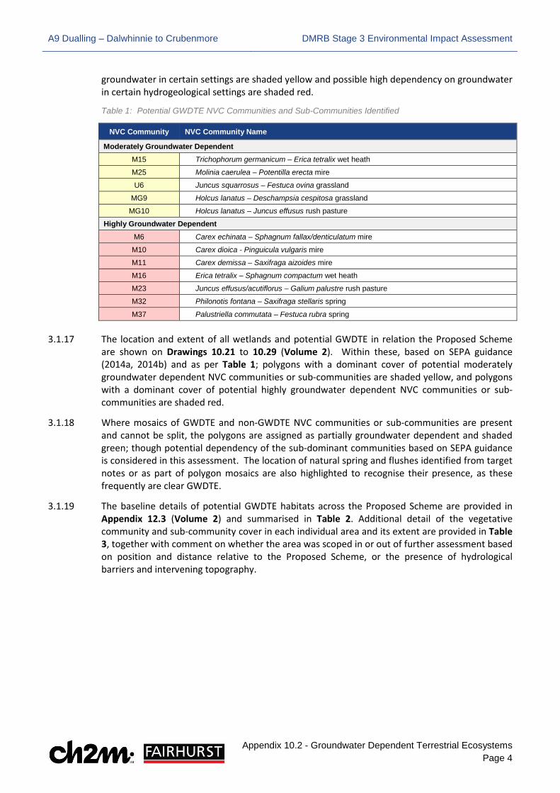
3.1.15 SEPA has classified several NVC communities as potentially dependent on groundwater sources (SEPA, 2014a, 2014b). Wetlands or habitats containing these communities are to be considered potential GWDTE unless further information can be provided to demonstrate this is not the case. Many of the NVC communities on the list are common habitat types across Scotland, and some are otherwise of generally low ecological value. Furthermore, some of the NVC communities may only be considered GWDTE in certain hydrogeological settings.
3.1.16 Using SEPA guidance (2014a, 2014b), Table 1 shows which communities recorded within the study area may be considered potential GWDTE. Those with potential moderate dependency on
A9 Dualling – Dalwhinnie to Crubenmore DMRB Stage 3 Environmental Impact Assessment
Appendix 10.2 - Groundwater Dependent Terrestrial Ecosystems Page 4
groundwater in certain settings are shaded yellow and possible high dependency on groundwater in certain hydrogeological settings are shaded red.
Table 1: Potential GWDTE NVC Communities and Sub-Communities Identified
NVC Community NVC Community Name
Moderately Groundwater Dependent M15 Trichophorum germanicum – Erica tetralix wet heath
M25 Molinia caerulea – Potentilla erecta mire
U6 Juncus squarrosus – Festuca ovina grassland
MG9 Holcus lanatus – Deschampsia cespitosa grassland
MG10 Holcus lanatus – Juncus effusus rush pasture
Highly Groundwater Dependent M6 Carex echinata – Sphagnum fallax/denticulatum mire
M10 Carex dioica - Pinguicula vulgaris mire
M11 Carex demissa – Saxifraga aizoides mire
M16 Erica tetralix – Sphagnum compactum wet heath
M23 Juncus effusus/acutiflorus – Galium palustre rush pasture
M32 Philonotis fontana – Saxifraga stellaris spring
M37 Palustriella commutata – Festuca rubra spring
3.1.17 The location and extent of all wetlands and potential GWDTE in relation the Proposed Scheme are shown on Drawings 10.21 to 10.29 (Volume 2). Within these, based on SEPA guidance (2014a, 2014b) and as per Table 1; polygons with a dominant cover of potential moderately groundwater dependent NVC communities or sub-communities are shaded yellow, and polygons with a dominant cover of potential highly groundwater dependent NVC communities or sub-communities are shaded red.
3.1.18 Where mosaics of GWDTE and non-GWDTE NVC communities or sub-communities are present and cannot be split, the polygons are assigned as partially groundwater dependent and shaded green; though potential dependency of the sub-dominant communities based on SEPA guidance is considered in this assessment. The location of natural spring and flushes identified from target notes or as part of polygon mosaics are also highlighted to recognise their presence, as these frequently are clear GWDTE.
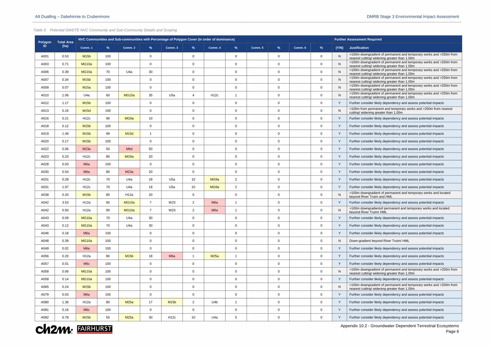
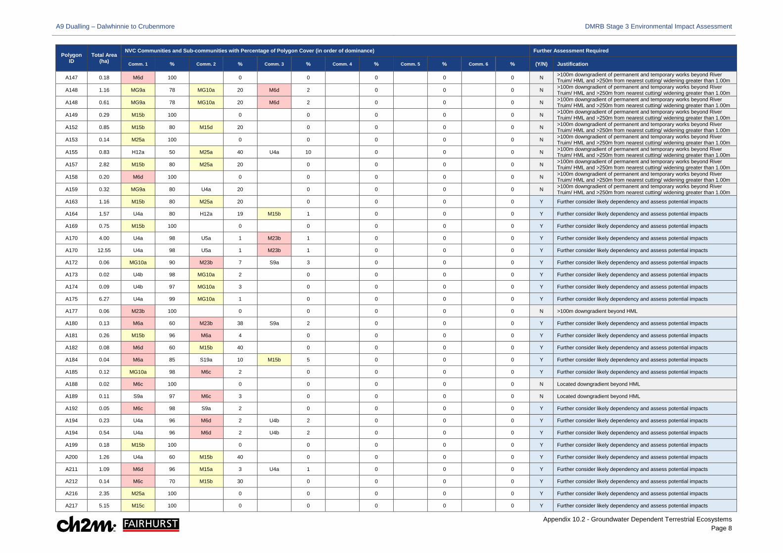
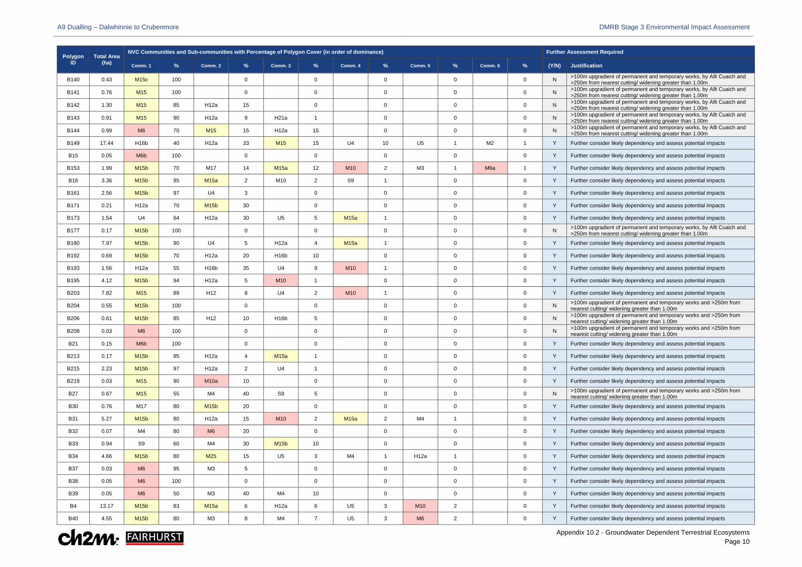
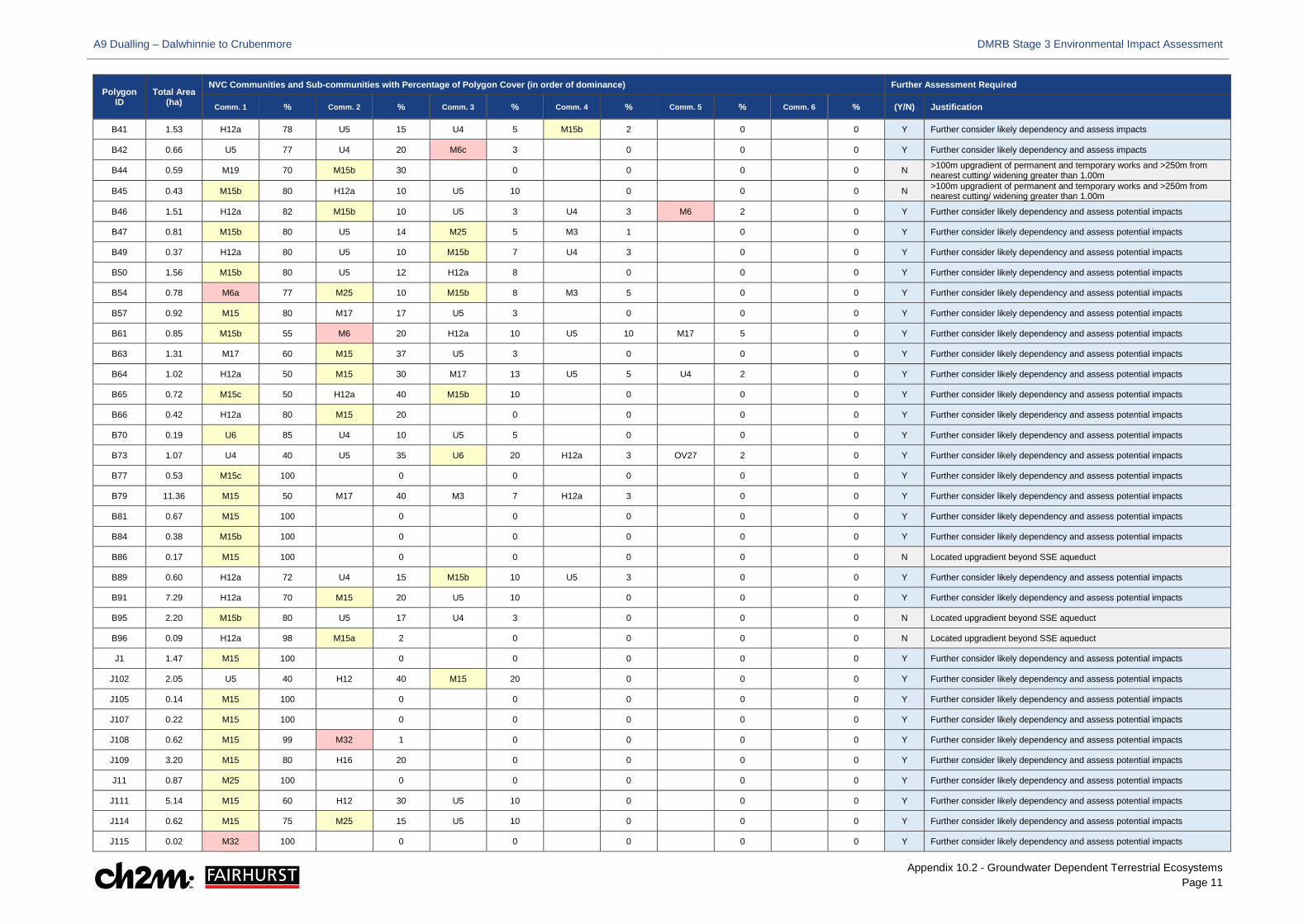
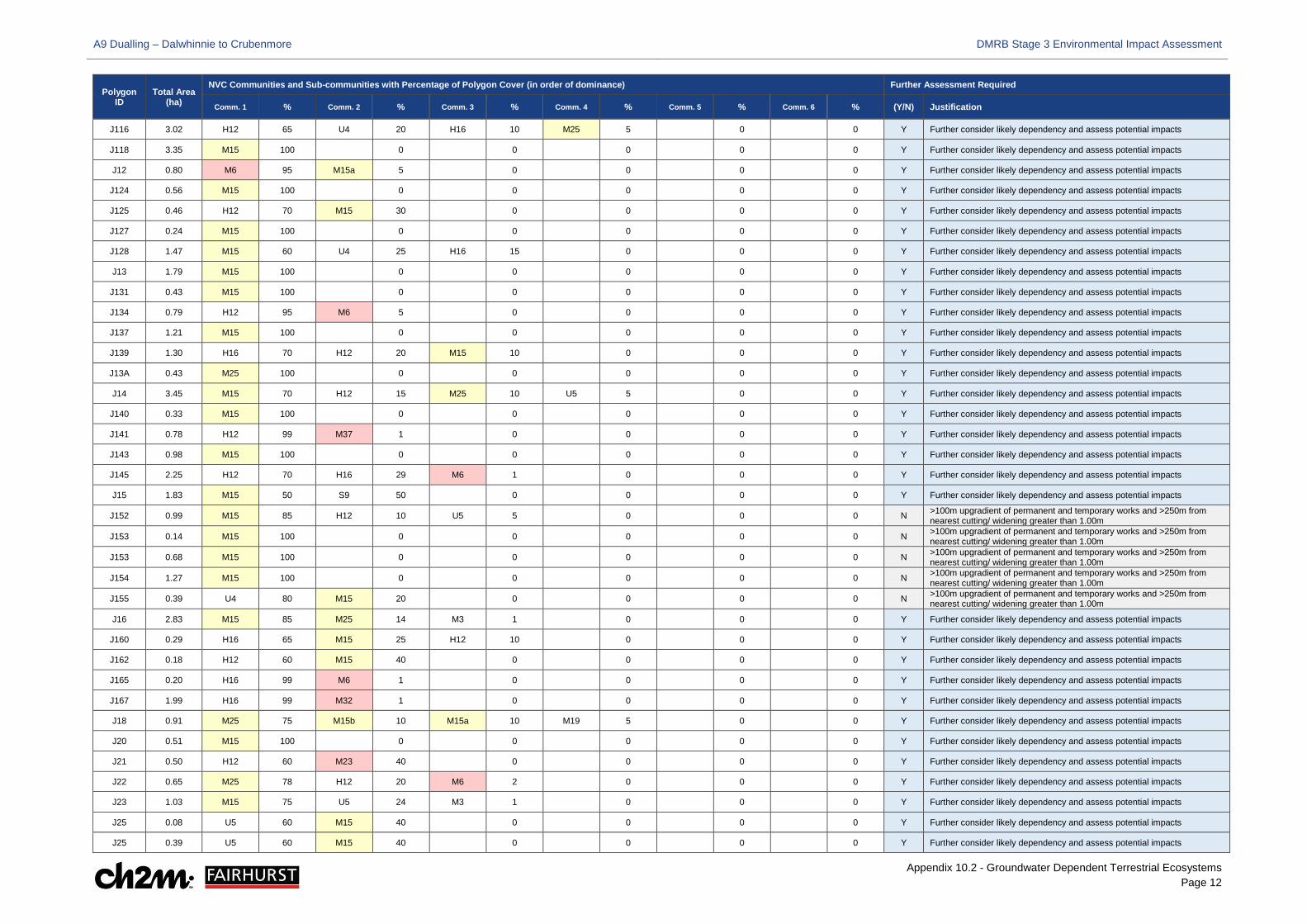
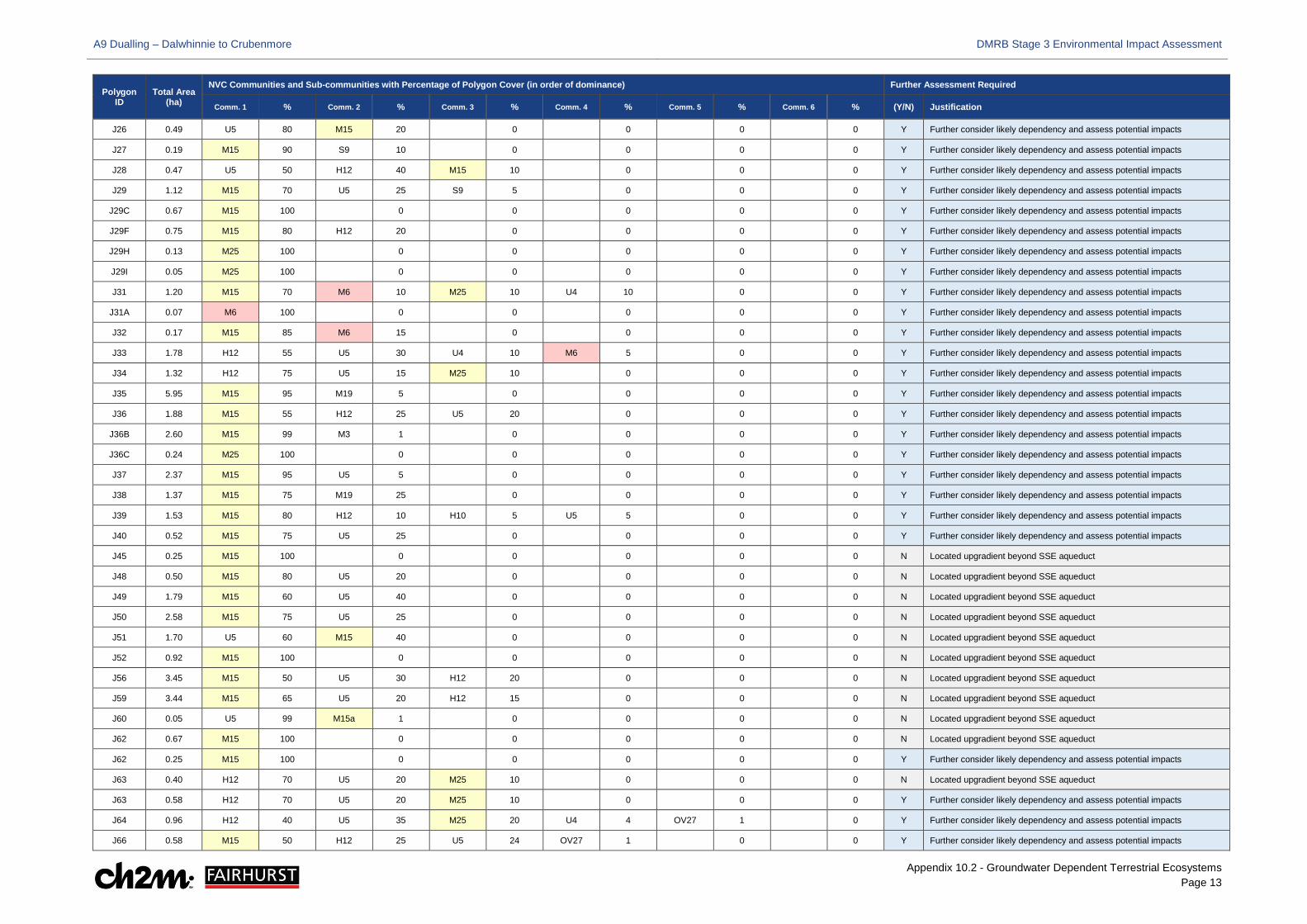
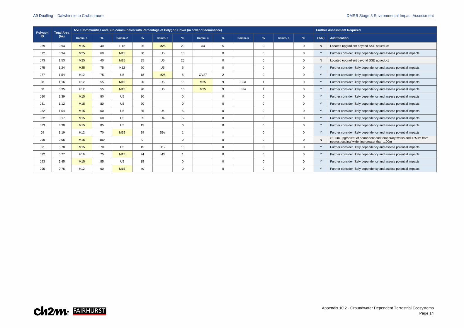
3.1.19 The baseline details of potential GWDTE habitats across the Proposed Scheme are provided in Appendix 12.3 (Volume 2) and summarised in Table 2. Additional detail of the vegetative community and sub-community cover in each individual area and its extent are provided in Table 3, together with comment on whether the area was scoped in or out of further assessment based on position and distance relative to the Proposed Scheme, or the presence of hydrological barriers and intervening topography.
A9 Dualling – Dalwhinnie to Crubenmore DMRB Stage 3 Environmental Impact Assessment
Appendix 10.2 - Groundwater Dependent Terrestrial Ecosystems Page 5
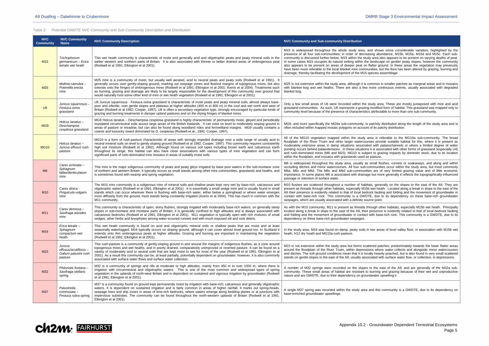
Table 2: Potential GWDTE NVC Community and Sub-Community Description and Distribution
NVC Community
NVC Community Name NVC Community Description NVC Community and Sub-community Distribution
M15 Trichophorum germanicum – Erica tetralix wet heath
This wet heath community is characteristic of moist and generally acid and oligotrophic peats and peaty mineral soils in the wetter western and northern parts of Britain. It is also associated with thinner or better drained areas of ombrogenous peat (Rodwell et al 1991; Elkington et al 2001).
M15 is widespread throughout the whole study area, and shows some considerable variation, highlighted by the presence of all four sub-communities; in order of decreasing abundance, M15b, M15a, M15d and M15c. Each sub-community is discussed further below. M15 within the study area also appears to be present on varying depths of peat. In some cases M15 occupies its natural setting within the landscape on gentler peaty slopes; however the community also appears to be present on areas of deeper peat on flatter ground. In these areas the vegetation may previously have been more referable to the local blanket mire communities, but the flora has been altered by grazing, burning and drainage, thereby facilitating the development of the M15 species assemblage.
M25 Molinia caerulea – Potentilla erecta mire
M25 mire is a community of moist, but usually well aerated, acid to neutral peats and peaty soils (Rodwell et al 1991). It generally occurs over gently-sloping ground, marking out seepage zones and flushed margins of topogenous mires, but also extends onto the fringes of ombrogenous mires (Rodwell et al 1991; Elkington et al 2001; Averis et al 2004). Treatments such as burning, grazing and drainage are likely to be largely responsible for the development of this community over ground that would naturally host some other kind of mire or wet heath vegetation (Rodwell et al 1991; Elkington et al 2001).
M25 is not extensive within the study area, although it is common in smaller patches as marginal areas and in mosaics with blanket bog and wet heaths. There are also a few more continuous extents, usually associated with degraded blanket bog.
U6 Juncus squarrosus – Festuca ovina grassland
U6 Juncus squarrosus - Festuca ovina grassland is characteristic of moist peats and peaty mineral soils, almost always base-poor and infertile, over gentle slopes and plateaux at higher altitudes (400 m to 800 m) in the cool and wet north and west of Britain (Rodwell et al 1992; Cooper, 1997). U6 is often a secondary vegetation type, strongly encouraged by particular kinds of grazing and burning treatments in damper upland pastures and on the drying fringes of blanket mires.
Only a few small areas of U6 were recorded within the study area. These are mostly juxtaposed with mire and acid grassland communities. As such, U6 represents a grazing-modified form of habitat. This grassland was mapped only to community level because of the presence of characteristics attributable to more than one sub-community.
MG9 Holcus lanatus – Deschampsia cespitosa grassland
MG9 Holcus lanatus – Deschampsia cespitosa grassland is highly characteristic of permanently moist, gleyed and periodically inundated circumneutral soils across large areas of the British lowlands. It can exist on level to moderately sloping ground in areas of pasture or meadow, but can also be found along woodland rides and fen/wetland margins. MG9 usually contains a coarse and tussocky sward dominated by D. cespitosa (Rodwell et al., 1992; Cooper, 1997).
MG9, and more specifically the MG9a sub-community, is patchily distributed along the length of the study area and is often included within mapped mosaic polygons on account of its patchy distribution.
MG10 Holcus lanatus – Juncus effusus rush pasture
MG10 is a form of rush-pasture characteristic of areas with strongly impeded drainage over a wide range of usually acid to neutral mineral soils on level to gently sloping ground (Rodwell et al 1992; Cooper, 1997). This community requires consistently high soil moisture (Rodwell et al 1992). Although found on various soil types including brown earth and calcareous earth throughout its range, this habitat can also have close associations with various types of mire vegetation and can form significant parts of rush-dominated mire mosaics in areas of suitably moist soils.
All of the MG10 vegetation mapped within the study area is referable to the MG10a sub-community. The broad floodplain of the River Truim and other larger watercourses provide suitable habitat for this, where it is present as moderately extensive areas in damp situations associated with palaeochannels or where a limited degree of water ponding occurs behind palaeoterraces. In these situations it is associated with other forms of grassland (especially U4) and rush-dominated mires (M6 and M23). MG10 is subject to grazing impacts by domestic stock, due to its location within the floodplain, and mosaics with grasslands used as pasture.
M6
Carex echinata – Sphagnum fallax/denticulatum mire
This mire is the major soligenous community of peats and peaty gleys irrigated by base poor waters in the sub-montane zone of northern and western Britain. It typically occurs as small stands among other mire communities, grasslands and heaths, and is sometimes found with swamp and spring vegetation.
M6 is widespread throughout the study area, usually as small flushes, runnels or soakaways, and along and within occluding ditches and minor watercourses. All four sub-communities occur within the study area, but most commonly M6a, M6c and M6d. The M6c and M6d sub-communities are of very limited grazing value and of little economic importance. In some places M6 is associated with drainage but more generally it reflects the topographically-influenced passage or retention of surface water.
M10 Carex dioica - Pinguicula vulgaris mire
The M10 mire community is a soligenous mire of mineral soils and shallow peats kept very wet by base-rich, calcareous and oligotrophic waters (Rodwell et al 1991; Elkington et al 2001). It is essentially a small sedge mire and is usually found in small stands which can occur wherever there is flushing with base-rich water, either below a springhead or where water emerges more diffusely from the ground, most stands being constantly irrigated (Averis et al 2004). This has much in common with the M11 community.
M10 flushes are scattered throughout a number of habitats, generally on the slopes to the east of the A9. They are present as threads through other habitats, especially M15b wet heath. Located along a break in slope to the east of the A9 their presence is evidently related to that of local bedrock faulting and folding and the movement of groundwater in contact with base-rich rock. This community is a GWDTE, due to its dependency on these base-rich groundwater seepages, which are usually associated with a definite source point.
M11 Carex demissa – Saxifraga aizoides mire
This community is characteristic of open, stony flushes, strongly irrigated with moderately base-rich waters, on generally steep slopes in sub-montane and montane parts of Britain; it is generally confined to high altitudes and is always associated with calcareous bedrocks (Rodwell et al 1991; Elkington et al 2001). M11 vegetation is typically open with rich mixtures of small sedges, other herbs and bryophytes among water-scoured runnels and with much exposed silt and rock debris.
As with the M10 community, M11 is present as threads through other habitats, especially M15b wet heath. Principally located along a break in slope to the east of the A9, their presence is evidently related to that of local bedrock faulting and folding and the movement of groundwater in contact with base-rich rock. This community is a GWDTE, due to its dependency on these base-rich groundwater seepages.
M16
Erica tetralix – Sphagnum compactum wet heath
This wet heath community is found on acid and oligotrophic mineral soils or shallow peats that are moist and at least seasonally waterlogged. M16 typically occurs on sloping ground, although it can cover almost level ground too. In Scotland it extends onto thin ombrogenous peats at higher altitudes. Grazing and burning are important in maintaining the vegetation (Rodwell et al 1991; Elkington et al 2001).
In the study area, M16 was found on damp, peaty soils in two areas of level valley floor, in association with M15b wet heath, H12 dry heath and MG10a rush-pasture.
M23
Juncus effusus/acutiflorus – Galium palustre rush pasture
This rush-pasture is a community of gently-sloping ground in and around the margins of soligenous flushes, as a zone around topogenous mires and wet heaths, and in poorly drained, comparatively unimproved or reverted pasture. It can be found on a variety of moderately acid to neutral soils that are kept moist to wet for most of the year (Rodwell et al 1991; Elkington et al 2001). As a result this community can be, at least partially, potentially dependent on groundwater; however, it is also commonly associated with surface water flows and surface water collection.
M23 is not extensive within the study area but forms scattered patches, predominately towards the lower flatter areas around the floodplain of the River Truim, within depressions where water collects and alongside minor watercourses and ditches. The soft ground conditions mean that it is locally heavily poached, but is also found in very small scattered stands on gentle slopes to the east of the A9, usually associated with surface water flow, or collection, in depressions.
M32 Philonotis fontana – Saxifraga stellaris spring
M32 is a community of springs and rills at moderate to high altitudes, mainly from 450 m to over 1000 m, where there is irrigation with circumneutral and oligotrophic waters. This is one of the most common and widespread types of spring vegetation in the uplands of north-west Britain and is dependent on sustained and vigorous irrigation by groundwater (Rodwell et al 1991; Elkington et al 2001).
A number of M32 springs were recorded on the slopes to the east of the A9, and are generally of the M32a sub-community. These small areas of habitat are resistant to burning and grazing because of their wet and unproductive nature and are GWDTE, due to their dependency on groundwater upwelling’s.
M37 Palustriella commutata – Festuca rubra spring
M37 is a community found on ground kept permanently moist by irrigation with base-rich, calcareous and generally oligotrophic waters. It is dependent on sustained irrigation and is fairly common in areas of higher rainfall. It marks out spring-heads, seepage lines and drip zones in areas of lime-rich bedrocks, where waters emerge along bedding planes or at junctions with impervious substrates. The community can be found throughout the north-western uplands of Britain (Rodwell et al 1991; Elkington et al 2001).
A single M37 spring was recorded within the study area and this community is a GWDTE, due to its dependency on base-enriched groundwater upwellings.
A9 Dualling – Dalwhinnie to Crubenmore DMRB Stage 3 Environmental Impact Assessment
Appendix 10.2 - Groundwater Dependent Terrestrial Ecosystems Page 6
Table 3: Potential GWDTE NVC Community and Sub-Community Details and Scoping
Polygon ID
Total Area (ha)
NVC Communities and Sub-communities with Percentage of Polygon Cover (in order of dominance) Further Assessment Required
Comm. 1 % Comm. 2 % Comm. 3 % Comm. 4 % Comm. 5 % Comm. 6 % (Y/N) Justification
A001 0.53 M15b 100 0 0 0 0 0 N >100m downgradient of permanent and temporary works and >250m from nearest cutting/ widening greater than 1.00m
A003 0.71 MG10a 100 0 0 0 0 0 N >100m downgradient of permanent and temporary works and >250m from nearest cutting/ widening greater than 1.00m
A006 0.39 MG10a 70 U4a 30 0 0 0 0 N >100m downgradient of permanent and temporary works and >250m from nearest cutting/ widening greater than 1.00m
A007 0.34 M15b 100 0 0 0 0 0 N >100m downgradient of permanent and temporary works and >250m from nearest cutting/ widening greater than 1.00m
A009 0.07 M15a 100 0 0 0 0 0 N >100m downgradient of permanent and temporary works and >250m from nearest cutting/ widening greater than 1.00m
A010 1.06 U4a 60 MG10a 35 U5a 4 H12c 1 0 0 N >100m downgradient of permanent and temporary works and >250m from nearest cutting/ widening greater than 1.00m
A012 1.17 M15b 100 0 0 0 0 0 Y Further consider likely dependency and assess potential impacts
A013 0.16 M15d 100 0 0 0 0 0 N >100m from permanent and temporary works and >250m from nearest cutting/ widening greater than 1.00m
A016 0.21 H12c 90 MG9a 10 0 0 0 0 Y Further consider likely dependency and assess potential impacts
A018 0.12 M15b 100 0 0 0 0 0 Y Further consider likely dependency and assess potential impacts
A019 1.49 M15b 99 M15d 1 0 0 0 0 Y Further consider likely dependency and assess potential impacts
A020 0.17 M15b 100 0 0 0 0 0 Y Further consider likely dependency and assess potential impacts
A022 0.06 M23a 50 M6d 50 0 0 0 0 Y Further consider likely dependency and assess potential impacts
A023 0.23 H12c 80 MG9a 20 0 0 0 0 Y Further consider likely dependency and assess potential impacts
A028 0.03 M6a 100 0 0 0 0 0 Y Further consider likely dependency and assess potential impacts
A030 0.54 M6a 80 M23a 20 0 0 0 0 Y Further consider likely dependency and assess potential impacts
A031 0.28 H12c 70 U4a 18 U5a 10 MG9a 2 0 0 Y Further consider likely dependency and assess potential impacts
A031 1.97 H12c 70 U4a 18 U5a 10 MG9a 2 0 0 Y Further consider likely dependency and assess potential impacts
A038 0.20 M15b 80 H12a 20 0 0 0 0 N >100m downgradient of permanent and temporary works and located beyond River Truim and HML
A042 3.53 H12a 90 MG10a 7 W23 2 M6a 1 0 0 Y Further consider likely dependency and assess potential impacts
A042 0.50 H12a 90 MG10a 7 W23 2 M6a 1 0 0 N >100m downgradientof permanent and temporary works and located beyond River Truim/ HML
A043 0.09 MG10a 70 U4a 30 0 0 0 0 Y Further consider likely dependency and assess potential impacts
A043 0.12 MG10a 70 U4a 30 0 0 0 0 Y Further consider likely dependency and assess potential impacts
A046 0.18 M6a 100 0 0 0 0 0 Y Further consider likely dependency and assess potential impacts
A048 0.39 MG10a 100 0 0 0 0 0 N Down-gradient beyond River Truim/ HML
A049 0.02 M6a 100 0 0 0 0 0 Y Further consider likely dependency and assess potential impacts
A056 0.20 H12a 80 M15b 18 M6a 1 M25a 1 0 0 Y Further consider likely dependency and assess potential impacts
A057 0.01 M6c 100 0 0 0 0 0 Y Further consider likely dependency and assess potential impacts
A058 0.06 MG10a 100 0 0 0 0 0 N >100m downgradient of permanent and temporary works and >250m from nearest cutting/ widening greater than 1.00m
A058 0.14 MG10a 100 0 0 0 0 0 Y Further consider likely dependency and assess potential impacts
A065 0.24 M15b 100 0 0 0 0 0 N >100m downgradient of permanent and temporary works and >250m from nearest cutting/ widening greater than 1.00m
A079 0.03 M6a 100 0 0 0 0 0 Y Further consider likely dependency and assess potential impacts
A080 1.36 H12a 80 M25a 17 M15b 2 U4b 1 0 0 Y Further consider likely dependency and assess potential impacts
A081 0.16 M6c 100 0 0 0 0 0 Y Further consider likely dependency and assess potential impacts
A082 6.78 M15b 55 M25a 30 H12c 10 U4a 5 0 0 Y Further consider likely dependency and assess potential impacts
A9 Dualling – Dalwhinnie to Crubenmore DMRB Stage 3 Environmental Impact Assessment
Appendix 10.2 - Groundwater Dependent Terrestrial Ecosystems Page 7
Polygon ID
Total Area (ha)
NVC Communities and Sub-communities with Percentage of Polygon Cover (in order of dominance) Further Assessment Required
Comm. 1 % Comm. 2 % Comm. 3 % Comm. 4 % Comm. 5 % Comm. 6 % (Y/N) Justification
A083 1.01 H12a 80 M15b 20 0 0 0 0 Y Further consider likely dependency and assess potential impacts
A085 0.04 M6c 100 0 0 0 0 0 Y Further consider likely dependency and assess potential impacts
A088 2.92 M25a 100 0 0 0 0 0 Y Further consider likely dependency and assess potential impacts
A089 1.19 M6c 60 M25a 40 0 0 0 0 Y Further consider likely dependency and assess potential impacts
A092 3.47 H12a 80 M15b 20 0 0 0 0 Y Further consider likely dependency and assess potential impacts
A095 2.86 M4 98 M6a 2 0 0 0 0 N >100m downgradient and outwith nearest cutting/ widening zone of influence
A096 15.85 H12c 70 M15b 25 U4a 2 U5a 2 M6a 1 0 Y Further consider likely dependency and assess potential impacts
A098 0.07 MG9a 100 0 0 0 0 0 N >100m downgradient beyond SSE aqueduct and >250m from nearest cutting/ widening greater than 1.00m
A100 0.43 M25a 100 0 0 0 0 0 N >100m downgradient beyond SSE aqueduct and >250m from nearest cutting/ widening greater than 1.00m
A101 1.13 MG9a 50 U4a 25 H12a 20 U5a 5 0 0 N >100m downgradient beyond SSE aqueduct and >250m from nearest cutting/ widening greater than 1.00m
A104 16.15 H12c 60 M15b 36 U5c 2 M25a 1 M6c 1 0 Y Further consider likely dependency and assess potential impacts
A105 1.55 M25a 98 M15a 2 0 0 0 0 N >100m downgradient of permanent and temporary works and located beyond River Truim
A106 0.44 M15b 100 0 0 0 0 0 N >100m downgradient of permanent and temporary works and located beyond River Truim
A107 0.12 M15b 100 0 0 0 0 0 N >100m downgradient of permanent and temporary works and located beyond River Truim
A108 0.11 M6c 100 0 0 0 0 0 N >100m downgradient of permanent and temporary works and located beyond River Truim
A109 0.20 M25a 100 0 0 0 0 0 N >100m downgradient of permanent and temporary works and located beyond River Truim
A110N 0.18 U4 90 MG10a 8 H10c 2 0 0 0 N >100m downgradient of permanent and temporary works and located beyond River Truim
A110S 0.43 M6 99 M23a 1 0 0 0 0 N >100m downgradient of permanent and temporary works and located beyond River Truim
A111 1.26 U4b 60 MG10a 30 U5a 10 0 0 0 N >100m downgradient of permanent and temporary works and located beyond River Truim
A112 1.70 U6 60 U4a 30 U5a 9 M6c 1 0 0 N >100m downgradient of permanent and temporary works and located beyond River Truim
A116 0.55 M15b 100 0 0 0 0 0 N >100m downgradient of permanent and temporary works and located beyond River Truim
A118 0.83 M25a 100 0 0 0 0 0 N Located downgradient beyond River Truim
A119 1.71 U4b 72 H12c 20 MG10a 5 M6c 2 S9a 1 0 N Located downgradient beyond River Truim
A121 0.94 M25a 100 0 0 0 0 0 N Located downgradient beyond River Truim
A126 1.41 H12a 60 U4a 38 MG10a 2 0 0 0 Y Further consider likely dependency and assess potential impacts
A133 0.28 M6d 100 0 0 0 0 0 Y Further consider likely dependency and assess potential impacts
A136 0.63 M15b 100 0 0 0 0 0 Y Further consider likely dependency and assess potential impacts
A137 2.26 M6a 92 S9a 8 0 0 0 0 Y Further consider likely dependency and assess potential impacts
A138 2.98 M15d 100 0 0 0 0 0 Y Further consider likely dependency and assess potential impacts
A144 1.13 U4a 70 MG9a 20 MG10a 10 0 0 0 N >100m downgradient of permanent and temporary works beyond River Truim/ HML and >250m from nearest cutting/ widening greater than 1.00m
A144 0.37 U4a 70 MG9a 20 MG10a 10 0 0 0 N >100m downgradient of permanent and temporary works beyond River Truim/ HML and >250m from nearest cutting/ widening greater than 1.00m
A145 2.07 M15b 100 0 0 0 0 0 N >100m downgradient of permanent and temporary works beyond River Truim/ HML and >250m from nearest cutting/ widening greater than 1.00m
A146 0.14 M15d 100 0 0 0 0 0 N >100m downgradient of permanent and temporary works beyond River Truim/ HML and >250m from nearest cutting/ widening greater than 1.00m
A146 0.47 M15d 100 0 0 0 0 0 N >100m downgradient of permanent and temporary works beyond River Truim/ HML and >250m from nearest cutting/ widening greater than 1.00m
A147 0.24 M6d 100 0 0 0 0 0 N >100m downgradient of permanent and temporary works beyond River Truim/ HML and >250m from nearest cutting/ widening greater than 1.00m
A9 Dualling – Dalwhinnie to Crubenmore DMRB Stage 3 Environmental Impact Assessment
Appendix 10.2 - Groundwater Dependent Terrestrial Ecosystems Page 8
Polygon ID
Total Area (ha)
NVC Communities and Sub-communities with Percentage of Polygon Cover (in order of dominance) Further Assessment Required
Comm. 1 % Comm. 2 % Comm. 3 % Comm. 4 % Comm. 5 % Comm. 6 % (Y/N) Justification
A147 0.18 M6d 100 0 0 0 0 0 N >100m downgradient of permanent and temporary works beyond River Truim/ HML and >250m from nearest cutting/ widening greater than 1.00m
A148 1.16 MG9a 78 MG10a 20 M6d 2 0 0 0 N >100m downgradient of permanent and temporary works beyond River Truim/ HML and >250m from nearest cutting/ widening greater than 1.00m
A148 0.61 MG9a 78 MG10a 20 M6d 2 0 0 0 N >100m downgradient of permanent and temporary works beyond River Truim/ HML and >250m from nearest cutting/ widening greater than 1.00m
A149 0.29 M15b 100 0 0 0 0 0 N >100m downgradient of permanent and temporary works beyond River Truim/ HML and >250m from nearest cutting/ widening greater than 1.00m
A152 0.85 M15b 80 M15d 20 0 0 0 0 N >100m downgradient of permanent and temporary works beyond River Truim/ HML and >250m from nearest cutting/ widening greater than 1.00m
A153 0.14 M25a 100 0 0 0 0 0 N >100m downgradient of permanent and temporary works beyond River Truim/ HML and >250m from nearest cutting/ widening greater than 1.00m
A155 0.83 H12a 50 M25a 40 U4a 10 0 0 0 N >100m downgradient of permanent and temporary works beyond River Truim/ HML and >250m from nearest cutting/ widening greater than 1.00m
A157 2.82 M15b 80 M25a 20 0 0 0 0 N >100m downgradient of permanent and temporary works beyond River Truim/ HML and >250m from nearest cutting/ widening greater than 1.00m
A158 0.20 M6d 100 0 0 0 0 0 N >100m downgradient of permanent and temporary works beyond River Truim/ HML and >250m from nearest cutting/ widening greater than 1.00m
A159 0.32 MG9a 80 U4a 20 0 0 0 0 N >100m downgradient of permanent and temporary works beyond River Truim/ HML and >250m from nearest cutting/ widening greater than 1.00m
A163 1.16 M15b 80 M25a 20 0 0 0 0 Y Further consider likely dependency and assess potential impacts
A164 1.57 U4a 80 H12a 19 M15b 1 0 0 0 Y Further consider likely dependency and assess potential impacts
A169 0.75 M15b 100 0 0 0 0 0 Y Further consider likely dependency and assess potential impacts
A170 4.00 U4a 98 U5a 1 M23b 1 0 0 0 Y Further consider likely dependency and assess potential impacts
A170 12.55 U4a 98 U5a 1 M23b 1 0 0 0 Y Further consider likely dependency and assess potential impacts
A172 0.06 MG10a 90 M23b 7 S9a 3 0 0 0 Y Further consider likely dependency and assess potential impacts
A173 0.02 U4b 98 MG10a 2 0 0 0 0 Y Further consider likely dependency and assess potential impacts
A174 0.09 U4b 97 MG10a 3 0 0 0 0 Y Further consider likely dependency and assess potential impacts
A175 6.27 U4a 99 MG10a 1 0 0 0 0 Y Further consider likely dependency and assess potential impacts
A177 0.06 M23b 100 0 0 0 0 0 N >100m downgradient beyond HML
A180 0.13 M6a 60 M23b 38 S9a 2 0 0 0 Y Further consider likely dependency and assess potential impacts
A181 0.26 M15b 96 M6a 4 0 0 0 0 Y Further consider likely dependency and assess potential impacts
A182 0.08 M6d 60 M15b 40 0 0 0 0 Y Further consider likely dependency and assess potential impacts
A184 0.04 M6a 85 S19a 10 M15b 5 0 0 0 Y Further consider likely dependency and assess potential impacts
A185 0.12 MG10a 98 M6c 2 0 0 0 0 Y Further consider likely dependency and assess potential impacts
A188 0.02 M6c 100 0 0 0 0 0 N Located downgradient beyond HML
A189 0.11 S9a 97 M6c 3 0 0 0 0 N Located downgradient beyond HML
A192 0.05 M6c 98 S9a 2 0 0 0 0 Y Further consider likely dependency and assess potential impacts
A194 0.23 U4a 96 M6d 2 U4b 2 0 0 0 Y Further consider likely dependency and assess potential impacts
A194 0.54 U4a 96 M6d 2 U4b 2 0 0 0 Y Further consider likely dependency and assess potential impacts
A199 0.18 M15b 100 0 0 0 0 0 Y Further consider likely dependency and assess potential impacts
A200 1.26 U4a 60 M15b 40 0 0 0 0 Y Further consider likely dependency and assess potential impacts
A211 1.09 M6d 96 M15a 3 U4a 1 0 0 0 Y Further consider likely dependency and assess potential impacts
A212 0.14 M6c 70 M15b 30 0 0 0 0 Y Further consider likely dependency and assess potential impacts
A216 2.35 M25a 100 0 0 0 0 0 Y Further consider likely dependency and assess potential impacts
A217 5.15 M15c 100 0 0 0 0 0 Y Further consider likely dependency and assess potential impacts

A9 Dualling – Dalwhinnie to Crubenmore DMRB Stage 3 Environmental Impact Assessment
Appendix 10.2 - Groundwater Dependent Terrestrial Ecosystems Page 9
Polygon ID
Total Area (ha)
NVC Communities and Sub-communities with Percentage of Polygon Cover (in order of dominance) Further Assessment Required
Comm. 1 % Comm. 2 % Comm. 3 % Comm. 4 % Comm. 5 % Comm. 6 % (Y/N) Justification
A224 0.23 U5a 65 M25a 35 0 0 0 0 Y Further consider likely dependency and assess potential impacts
A226 5.28 M16d 48 M15b 48 M25a 3 M6a 1 0 0 Y Further consider likely dependency and assess potential impacts
A232 0.28 M15b 57 M6a 30 M25a 7 H12a 5 M10a 1 0 N >100m downgradient from permanent and temporary works and >250m from nearest cutting/ widening greater than 1.00m
A235 0.06 M15b 95 M11b 3 M32a 2 0 0 0 Y Further consider likely dependency and assess potential impacts
A236 0.26 M15b 60 H12a 40 0 0 0 0 Y Further consider likely dependency and assess potential impacts
A237 0.32 M15b 99 M19a 1 0 0 0 0 Y Further consider likely dependency and assess potential impacts
A239 1.23 M15b 81 M6c 18 M10a 1 0 0 0 Y Further consider likely dependency and assess potential impacts
A240 0.80 M15b 93 H12a 5 M6c 1 M10a 1 0 0 Y Further consider likely dependency and assess potential impacts
A242 0.32 M15b 99 M6a 1 0 0 0 0 Y Further consider likely dependency and assess potential impacts
A246 0.76 M15b 98 H12a 2 0 0 0 0 Y Further consider likely dependency and assess potential impacts
A248 0.24 M15b 70 M6a 30 0 0 0 0 Y Further consider likely dependency and assess potential impacts
A249 0.11 M15b 60 M19a 40 0 0 0 0 N >100m downgradient from permanent and temporary works and >250m from nearest cutting/ widening greater than 1.00m
A259 1.61 M15b 57 H12a 42 M32a 1 0 0 0 Y Further consider likely dependency and assess potential impacts
A260 2.10 M15b 85 H12a 10 U4a 2 M6a 1 M32a 1 M10a 1 Y Further consider likely dependency and assess potential impacts
A266 1.30 M16 49 H12a 25 MG10a 20 M19a 5 U4 1 0 Y Further consider likely dependency and assess potential impacts
A267 0.28 M6d 100 0 0 0 0 0 N >100m downgradient from permanent and temporary works and >250m from nearest cutting/ widening greater than 1.00m
A275 1.48 H12a 65 H16a 30 M15b 5 0 0 0 Y Further consider likely dependency and assess potential impacts
B102 0.81 M15b 75 H12a 15 U5 7 U4 3 0 0 N Located upgradient beyond SSE aqueduct
B107 1.39 M15 65 U5 17 H12a 6 U4 5 M19 5 U6 2 Y Further consider likely dependency and assess potential impacts
B108 0.29 M15d 100 0 0 0 0 0 Y Further consider likely dependency and assess potential impacts
B109 0.10 M15b 100 0 0 0 0 0 Y Further consider likely dependency and assess potential impacts
B111 0.12 M15b 100 0 0 0 0 0 Y Further consider likely dependency and assess potential impacts
B115 0.67 M15a 78 M17 20 M6 1 S9 1 0 0 Y Further consider likely dependency and assess potential impacts
B116 0.40 M15a 100 0 0 0 0 0 Y Further consider likely dependency and assess potential impacts
B117 0.25 M6 100 0 0 0 0 0 Y Further consider likely dependency and assess potential impacts
B12 7.24 M15b 80 M15a 9 H12a 7 S9 2 M4 2 0 Y Further consider likely dependency and assess potential impacts
B120 0.19 M6 100 0 0 0 0 0 Y Further consider likely dependency and assess potential impacts
B121 0.05 M6 100 0 0 0 0 0 Y Further consider likely dependency and assess potential impacts
B125 0.63 M15b 98 M15a 1 M3 1 0 0 0 Y Further consider likely dependency and assess potential impacts
B126 0.45 M15b 99 M3 1 0 0 0 0 Y Further consider likely dependency and assess potential impacts
B128 0.30 M6 80 M15b 20 0 0 0 0 Y Further consider likely dependency and assess potential impacts
B129 0.18 M15b 100 0 0 0 0 0 Y Further consider likely dependency and assess potential impacts
B132 0.03 M15b 100 0 0 0 0 0 Y Further consider likely dependency and assess potential impacts
B133 0.13 M15b 100 0 0 0 0 0 Y Further consider likely dependency and assess potential impacts
B134 0.11 M6 100 0 0 0 0 0 Y Further consider likely dependency and assess potential impacts
B135 0.13 M15b 100 0 0 0 0 0 Y Further consider likely dependency and assess potential impacts
A9 Dualling – Dalwhinnie to Crubenmore DMRB Stage 3 Environmental Impact Assessment
Appendix 10.2 - Groundwater Dependent Terrestrial Ecosystems Page 10
Polygon ID
Total Area (ha)
NVC Communities and Sub-communities with Percentage of Polygon Cover (in order of dominance) Further Assessment Required
Comm. 1 % Comm. 2 % Comm. 3 % Comm. 4 % Comm. 5 % Comm. 6 % (Y/N) Justification
B140 0.43 M15c 100 0 0 0 0 0 N >100m upgradient of permanent and temporary works, by Allt Cuaich and >250m from nearest cutting/ widening greater than 1.00m
B141 0.76 M15 100 0 0 0 0 0 N >100m upgradient of permanent and temporary works, by Allt Cuaich and >250m from nearest cutting/ widening greater than 1.00m
B142 1.30 M15 85 H12a 15 0 0 0 0 N >100m upgradient of permanent and temporary works, by Allt Cuaich and >250m from nearest cutting/ widening greater than 1.00m
B143 0.91 M15 90 H12a 9 H21a 1 0 0 0 N >100m upgradient of permanent and temporary works, by Allt Cuaich and >250m from nearest cutting/ widening greater than 1.00m
B144 0.99 M6 70 M15 15 H12a 15 0 0 0 N >100m upgradient of permanent and temporary works, by Allt Cuaich and >250m from nearest cutting/ widening greater than 1.00m
B149 17.44 H16b 40 H12a 33 M15 15 U4 10 U5 1 M2 1 Y Further consider likely dependency and assess potential impacts
B15 0.05 M6b 100 0 0 0 0 0 Y Further consider likely dependency and assess potential impacts
B153 1.99 M15b 70 M17 14 M15a 12 M10 2 M3 1 M6a 1 Y Further consider likely dependency and assess potential impacts
B16 3.36 M15b 95 M15a 2 M10 2 S9 1 0 0 Y Further consider likely dependency and assess potential impacts
B161 2.56 M15b 97 U4 3 0 0 0 0 Y Further consider likely dependency and assess potential impacts
B171 0.21 H12a 70 M15b 30 0 0 0 0 Y Further consider likely dependency and assess potential impacts
B173 1.54 U4 64 H12a 30 U5 5 M15a 1 0 0 Y Further consider likely dependency and assess potential impacts
B177 0.17 M15b 100 0 0 0 0 0 N >100m upgradient of permanent and temporary works, by Allt Cuaich and >250m from nearest cutting/ widening greater than 1.00m
B180 7.97 M15b 90 U4 5 H12a 4 M15a 1 0 0 Y Further consider likely dependency and assess potential impacts
B192 0.69 M15b 70 H12a 20 H16b 10 0 0 0 Y Further consider likely dependency and assess potential impacts
B193 1.56 H12a 55 H16b 35 U4 9 M10 1 0 0 Y Further consider likely dependency and assess potential impacts
B195 4.12 M15b 94 H12a 5 M10 1 0 0 0 Y Further consider likely dependency and assess potential impacts
B203 7.82 M15 89 H12 8 U4 2 M10 1 0 0 Y Further consider likely dependency and assess potential impacts
B204 0.55 M15b 100 0 0 0 0 0 N >100m upgradient of permanent and temporary works and >250m from nearest cutting/ widening greater than 1.00m
B206 0.61 M15b 85 H12 10 H16b 5 0 0 0 N >100m upgradient of permanent and temporary works and >250m from nearest cutting/ widening greater than 1.00m
B208 0.03 M6 100 0 0 0 0 0 N >100m upgradient of permanent and temporary works and >250m from nearest cutting/ widening greater than 1.00m
B21 0.15 M6b 100 0 0 0 0 0 Y Further consider likely dependency and assess potential impacts
B213 0.17 M15b 95 H12a 4 M15a 1 0 0 0 Y Further consider likely dependency and assess potential impacts
B215 2.23 M15b 97 H12a 2 U4 1 0 0 0 Y Further consider likely dependency and assess potential impacts
B219 0.03 M15 90 M10a 10 0 0 0 0 Y Further consider likely dependency and assess potential impacts
B27 0.67 M15 55 M4 40 S9 5 0 0 0 N >100m upgradient of permanent and temporary works and >250m from nearest cutting/ widening greater than 1.00m
B30 0.76 M17 80 M15b 20 0 0 0 0 Y Further consider likely dependency and assess potential impacts
B31 5.27 M15b 80 H12a 15 M10 2 M15a 2 M4 1 0 Y Further consider likely dependency and assess potential impacts
B32 0.07 M4 80 M6 20 0 0 0 0 Y Further consider likely dependency and assess potential impacts
B33 0.94 S9 60 M4 30 M15b 10 0 0 0 Y Further consider likely dependency and assess potential impacts
B34 4.66 M15b 80 M25 15 U5 3 M4 1 H12a 1 0 Y Further consider likely dependency and assess potential impacts
B37 0.03 M6 95 M3 5 0 0 0 0 Y Further consider likely dependency and assess potential impacts
B38 0.05 M6 100 0 0 0 0 0 Y Further consider likely dependency and assess potential impacts
B39 0.05 M6 50 M3 40 M4 10 0 0 0 Y Further consider likely dependency and assess potential impacts
B4 13.17 M15b 83 M15a 6 H12a 6 U5 3 M10 2 0 Y Further consider likely dependency and assess potential impacts
B40 4.55 M15b 80 M3 8 M4 7 U5 3 M6 2 0 Y Further consider likely dependency and assess potential impacts
A9 Dualling – Dalwhinnie to Crubenmore DMRB Stage 3 Environmental Impact Assessment
Appendix 10.2 - Groundwater Dependent Terrestrial Ecosystems Page 11
Polygon ID
Total Area (ha)
NVC Communities and Sub-communities with Percentage of Polygon Cover (in order of dominance) Further Assessment Required
Comm. 1 % Comm. 2 % Comm. 3 % Comm. 4 % Comm. 5 % Comm. 6 % (Y/N) Justification
B41 1.53 H12a 78 U5 15 U4 5 M15b 2 0 0 Y Further consider likely dependency and assess impacts
B42 0.66 U5 77 U4 20 M6c 3 0 0 0 Y Further consider likely dependency and assess impacts
B44 0.59 M19 70 M15b 30 0 0 0 0 N >100m upgradient of permanent and temporary works and >250m from nearest cutting/ widening greater than 1.00m
B45 0.43 M15b 80 H12a 10 U5 10 0 0 0 N >100m upgradient of permanent and temporary works and >250m from nearest cutting/ widening greater than 1.00m
B46 1.51 H12a 82 M15b 10 U5 3 U4 3 M6 2 0 Y Further consider likely dependency and assess potential impacts
B47 0.81 M15b 80 U5 14 M25 5 M3 1 0 0 Y Further consider likely dependency and assess potential impacts
B49 0.37 H12a 80 U5 10 M15b 7 U4 3 0 0 Y Further consider likely dependency and assess potential impacts
B50 1.56 M15b 80 U5 12 H12a 8 0 0 0 Y Further consider likely dependency and assess potential impacts
B54 0.78 M6a 77 M25 10 M15b 8 M3 5 0 0 Y Further consider likely dependency and assess potential impacts
B57 0.92 M15 80 M17 17 U5 3 0 0 0 Y Further consider likely dependency and assess potential impacts
B61 0.85 M15b 55 M6 20 H12a 10 U5 10 M17 5 0 Y Further consider likely dependency and assess potential impacts
B63 1.31 M17 60 M15 37 U5 3 0 0 0 Y Further consider likely dependency and assess potential impacts
B64 1.02 H12a 50 M15 30 M17 13 U5 5 U4 2 0 Y Further consider likely dependency and assess potential impacts
B65 0.72 M15c 50 H12a 40 M15b 10 0 0 0 Y Further consider likely dependency and assess potential impacts
B66 0.42 H12a 80 M15 20 0 0 0 0 Y Further consider likely dependency and assess potential impacts
B70 0.19 U6 85 U4 10 U5 5 0 0 0 Y Further consider likely dependency and assess potential impacts
B73 1.07 U4 40 U5 35 U6 20 H12a 3 OV27 2 0 Y Further consider likely dependency and assess potential impacts
B77 0.53 M15c 100 0 0 0 0 0 Y Further consider likely dependency and assess potential impacts
B79 11.36 M15 50 M17 40 M3 7 H12a 3 0 0 Y Further consider likely dependency and assess potential impacts
B81 0.67 M15 100 0 0 0 0 0 Y Further consider likely dependency and assess potential impacts
B84 0.38 M15b 100 0 0 0 0 0 Y Further consider likely dependency and assess potential impacts
B86 0.17 M15 100 0 0 0 0 0 N Located upgradient beyond SSE aqueduct
B89 0.60 H12a 72 U4 15 M15b 10 U5 3 0 0 Y Further consider likely dependency and assess potential impacts
B91 7.29 H12a 70 M15 20 U5 10 0 0 0 Y Further consider likely dependency and assess potential impacts
B95 2.20 M15b 80 U5 17 U4 3 0 0 0 N Located upgradient beyond SSE aqueduct
B96 0.09 H12a 98 M15a 2 0 0 0 0 N Located upgradient beyond SSE aqueduct
J1 1.47 M15 100 0 0 0 0 0 Y Further consider likely dependency and assess potential impacts
J102 2.05 U5 40 H12 40 M15 20 0 0 0 Y Further consider likely dependency and assess potential impacts
J105 0.14 M15 100 0 0 0 0 0 Y Further consider likely dependency and assess potential impacts
J107 0.22 M15 100 0 0 0 0 0 Y Further consider likely dependency and assess potential impacts
J108 0.62 M15 99 M32 1 0 0 0 0 Y Further consider likely dependency and assess potential impacts
J109 3.20 M15 80 H16 20 0 0 0 0 Y Further consider likely dependency and assess potential impacts
J11 0.87 M25 100 0 0 0 0 0 Y Further consider likely dependency and assess potential impacts
J111 5.14 M15 60 H12 30 U5 10 0 0 0 Y Further consider likely dependency and assess potential impacts
J114 0.62 M15 75 M25 15 U5 10 0 0 0 Y Further consider likely dependency and assess potential impacts
J115 0.02 M32 100 0 0 0 0 0 Y Further consider likely dependency and assess potential impacts
A9 Dualling – Dalwhinnie to Crubenmore DMRB Stage 3 Environmental Impact Assessment
Appendix 10.2 - Groundwater Dependent Terrestrial Ecosystems Page 12
Polygon ID
Total Area (ha)
NVC Communities and Sub-communities with Percentage of Polygon Cover (in order of dominance) Further Assessment Required
Comm. 1 % Comm. 2 % Comm. 3 % Comm. 4 % Comm. 5 % Comm. 6 % (Y/N) Justification
J116 3.02 H12 65 U4 20 H16 10 M25 5 0 0 Y Further consider likely dependency and assess potential impacts
J118 3.35 M15 100 0 0 0 0 0 Y Further consider likely dependency and assess potential impacts
J12 0.80 M6 95 M15a 5 0 0 0 0 Y Further consider likely dependency and assess potential impacts
J124 0.56 M15 100 0 0 0 0 0 Y Further consider likely dependency and assess potential impacts
J125 0.46 H12 70 M15 30 0 0 0 0 Y Further consider likely dependency and assess potential impacts
J127 0.24 M15 100 0 0 0 0 0 Y Further consider likely dependency and assess potential impacts
J128 1.47 M15 60 U4 25 H16 15 0 0 0 Y Further consider likely dependency and assess potential impacts
J13 1.79 M15 100 0 0 0 0 0 Y Further consider likely dependency and assess potential impacts
J131 0.43 M15 100 0 0 0 0 0 Y Further consider likely dependency and assess potential impacts
J134 0.79 H12 95 M6 5 0 0 0 0 Y Further consider likely dependency and assess potential impacts
J137 1.21 M15 100 0 0 0 0 0 Y Further consider likely dependency and assess potential impacts
J139 1.30 H16 70 H12 20 M15 10 0 0 0 Y Further consider likely dependency and assess potential impacts
J13A 0.43 M25 100 0 0 0 0 0 Y Further consider likely dependency and assess potential impacts
J14 3.45 M15 70 H12 15 M25 10 U5 5 0 0 Y Further consider likely dependency and assess potential impacts
J140 0.33 M15 100 0 0 0 0 0 Y Further consider likely dependency and assess potential impacts
J141 0.78 H12 99 M37 1 0 0 0 0 Y Further consider likely dependency and assess potential impacts
J143 0.98 M15 100 0 0 0 0 0 Y Further consider likely dependency and assess potential impacts
J145 2.25 H12 70 H16 29 M6 1 0 0 0 Y Further consider likely dependency and assess potential impacts
J15 1.83 M15 50 S9 50 0 0 0 0 Y Further consider likely dependency and assess potential impacts
J152 0.99 M15 85 H12 10 U5 5 0 0 0 N >100m upgradient of permanent and temporary works and >250m from nearest cutting/ widening greater than 1.00m
J153 0.14 M15 100 0 0 0 0 0 N >100m upgradient of permanent and temporary works and >250m from nearest cutting/ widening greater than 1.00m
J153 0.68 M15 100 0 0 0 0 0 N >100m upgradient of permanent and temporary works and >250m from nearest cutting/ widening greater than 1.00m
J154 1.27 M15 100 0 0 0 0 0 N >100m upgradient of permanent and temporary works and >250m from nearest cutting/ widening greater than 1.00m
J155 0.39 U4 80 M15 20 0 0 0 0 N >100m upgradient of permanent and temporary works and >250m from nearest cutting/ widening greater than 1.00m
J16 2.83 M15 85 M25 14 M3 1 0 0 0 Y Further consider likely dependency and assess potential impacts
J160 0.29 H16 65 M15 25 H12 10 0 0 0 Y Further consider likely dependency and assess potential impacts
J162 0.18 H12 60 M15 40 0 0 0 0 Y Further consider likely dependency and assess potential impacts
J165 0.20 H16 99 M6 1 0 0 0 0 Y Further consider likely dependency and assess potential impacts
J167 1.99 H16 99 M32 1 0 0 0 0 Y Further consider likely dependency and assess potential impacts
J18 0.91 M25 75 M15b 10 M15a 10 M19 5 0 0 Y Further consider likely dependency and assess potential impacts
J20 0.51 M15 100 0 0 0 0 0 Y Further consider likely dependency and assess potential impacts
J21 0.50 H12 60 M23 40 0 0 0 0 Y Further consider likely dependency and assess potential impacts
J22 0.65 M25 78 H12 20 M6 2 0 0 0 Y Further consider likely dependency and assess potential impacts
J23 1.03 M15 75 U5 24 M3 1 0 0 0 Y Further consider likely dependency and assess potential impacts
J25 0.08 U5 60 M15 40 0 0 0 0 Y Further consider likely dependency and assess potential impacts
J25 0.39 U5 60 M15 40 0 0 0 0 Y Further consider likely dependency and assess potential impacts
A9 Dualling – Dalwhinnie to Crubenmore DMRB Stage 3 Environmental Impact Assessment
Appendix 10.2 - Groundwater Dependent Terrestrial Ecosystems Page 13
Polygon ID
Total Area (ha)
NVC Communities and Sub-communities with Percentage of Polygon Cover (in order of dominance) Further Assessment Required
Comm. 1 % Comm. 2 % Comm. 3 % Comm. 4 % Comm. 5 % Comm. 6 % (Y/N) Justification
J26 0.49 U5 80 M15 20 0 0 0 0 Y Further consider likely dependency and assess potential impacts
J27 0.19 M15 90 S9 10 0 0 0 0 Y Further consider likely dependency and assess potential impacts
J28 0.47 U5 50 H12 40 M15 10 0 0 0 Y Further consider likely dependency and assess potential impacts
J29 1.12 M15 70 U5 25 S9 5 0 0 0 Y Further consider likely dependency and assess potential impacts
J29C 0.67 M15 100 0 0 0 0 0 Y Further consider likely dependency and assess potential impacts
J29F 0.75 M15 80 H12 20 0 0 0 0 Y Further consider likely dependency and assess potential impacts
J29H 0.13 M25 100 0 0 0 0 0 Y Further consider likely dependency and assess potential impacts
J29I 0.05 M25 100 0 0 0 0 0 Y Further consider likely dependency and assess potential impacts
J31 1.20 M15 70 M6 10 M25 10 U4 10 0 0 Y Further consider likely dependency and assess potential impacts
J31A 0.07 M6 100 0 0 0 0 0 Y Further consider likely dependency and assess potential impacts
J32 0.17 M15 85 M6 15 0 0 0 0 Y Further consider likely dependency and assess potential impacts
J33 1.78 H12 55 U5 30 U4 10 M6 5 0 0 Y Further consider likely dependency and assess potential impacts
J34 1.32 H12 75 U5 15 M25 10 0 0 0 Y Further consider likely dependency and assess potential impacts
J35 5.95 M15 95 M19 5 0 0 0 0 Y Further consider likely dependency and assess potential impacts
J36 1.88 M15 55 H12 25 U5 20 0 0 0 Y Further consider likely dependency and assess potential impacts
J36B 2.60 M15 99 M3 1 0 0 0 0 Y Further consider likely dependency and assess potential impacts
J36C 0.24 M25 100 0 0 0 0 0 Y Further consider likely dependency and assess potential impacts
J37 2.37 M15 95 U5 5 0 0 0 0 Y Further consider likely dependency and assess potential impacts
J38 1.37 M15 75 M19 25 0 0 0 0 Y Further consider likely dependency and assess potential impacts
J39 1.53 M15 80 H12 10 H10 5 U5 5 0 0 Y Further consider likely dependency and assess potential impacts
J40 0.52 M15 75 U5 25 0 0 0 0 Y Further consider likely dependency and assess potential impacts
J45 0.25 M15 100 0 0 0 0 0 N Located upgradient beyond SSE aqueduct
J48 0.50 M15 80 U5 20 0 0 0 0 N Located upgradient beyond SSE aqueduct
J49 1.79 M15 60 U5 40 0 0 0 0 N Located upgradient beyond SSE aqueduct
J50 2.58 M15 75 U5 25 0 0 0 0 N Located upgradient beyond SSE aqueduct
J51 1.70 U5 60 M15 40 0 0 0 0 N Located upgradient beyond SSE aqueduct
J52 0.92 M15 100 0 0 0 0 0 N Located upgradient beyond SSE aqueduct
J56 3.45 M15 50 U5 30 H12 20 0 0 0 N Located upgradient beyond SSE aqueduct
J59 3.44 M15 65 U5 20 H12 15 0 0 0 N Located upgradient beyond SSE aqueduct
J60 0.05 U5 99 M15a 1 0 0 0 0 N Located upgradient beyond SSE aqueduct
J62 0.67 M15 100 0 0 0 0 0 N Located upgradient beyond SSE aqueduct
J62 0.25 M15 100 0 0 0 0 0 Y Further consider likely dependency and assess potential impacts
J63 0.40 H12 70 U5 20 M25 10 0 0 0 N Located upgradient beyond SSE aqueduct
J63 0.58 H12 70 U5 20 M25 10 0 0 0 Y Further consider likely dependency and assess potential impacts
J64 0.96 H12 40 U5 35 M25 20 U4 4 OV27 1 0 Y Further consider likely dependency and assess potential impacts
J66 0.58 M15 50 H12 25 U5 24 OV27 1 0 0 Y Further consider likely dependency and assess potential impacts
A9 Dualling – Dalwhinnie to Crubenmore DMRB Stage 3 Environmental Impact Assessment
Appendix 10.2 - Groundwater Dependent Terrestrial Ecosystems Page 14
Polygon ID
Total Area (ha)
NVC Communities and Sub-communities with Percentage of Polygon Cover (in order of dominance) Further Assessment Required
Comm. 1 % Comm. 2 % Comm. 3 % Comm. 4 % Comm. 5 % Comm. 6 % (Y/N) Justification
J69 0.94 M15 40 H12 35 M25 20 U4 5 0 0 N Located upgradient beyond SSE aqueduct
J72 0.94 M25 60 M15 30 U5 10 0 0 0 Y Further consider likely dependency and assess potential impacts
J73 1.53 M25 40 M15 35 U5 25 0 0 0 N Located upgradient beyond SSE aqueduct
J75 1.24 M25 75 H12 20 U5 5 0 0 0 Y Further consider likely dependency and assess potential impacts
J77 1.54 H12 75 U5 18 M25 5 OV27 2 0 0 Y Further consider likely dependency and assess potential impacts
J8 1.16 H12 55 M15 20 U5 15 M25 9 S9a 1 0 Y Further consider likely dependency and assess potential impacts
J8 0.35 H12 55 M15 20 U5 15 M25 9 S9a 1 0 Y Further consider likely dependency and assess potential impacts
J80 2.39 M15 80 U5 20 0 0 0 0 Y Further consider likely dependency and assess potential impacts
J81 1.12 M15 80 U5 20 0 0 0 0 Y Further consider likely dependency and assess potential impacts
J82 1.04 M15 60 U5 35 U4 5 0 0 0 Y Further consider likely dependency and assess potential impacts
J82 0.17 M15 60 U5 35 U4 5 0 0 0 Y Further consider likely dependency and assess potential impacts
J83 3.30 M15 85 U5 15 0 0 0 0 Y Further consider likely dependency and assess potential impacts
J9 1.19 H12 70 M25 29 S9a 1 0 0 0 Y Further consider likely dependency and assess potential impacts
J90 0.05 M15 100 0 0 0 0 0 N >100m upgradient of permanent and temporary works and >250m from nearest cutting/ widening greater than 1.00m
J91 5.78 M15 70 U5 15 H12 15 0 0 0 Y Further consider likely dependency and assess potential impacts
J92 0.77 H16 75 M15 24 M3 1 0 0 0 Y Further consider likely dependency and assess potential impacts
J93 2.45 M15 85 U5 15 0 0 0 0 Y Further consider likely dependency and assess potential impacts
J95 0.75 H12 60 M15 40 0 0 0 0 Y Further consider likely dependency and assess potential impacts
A9 Dualling – Dalwhinnie to Crubenmore DMRB Stage 3 Environmental Impact Assessment
Appendix 10.2 - Groundwater Dependent Terrestrial Ecosystems Page 15
Assessment of Likely Dependence
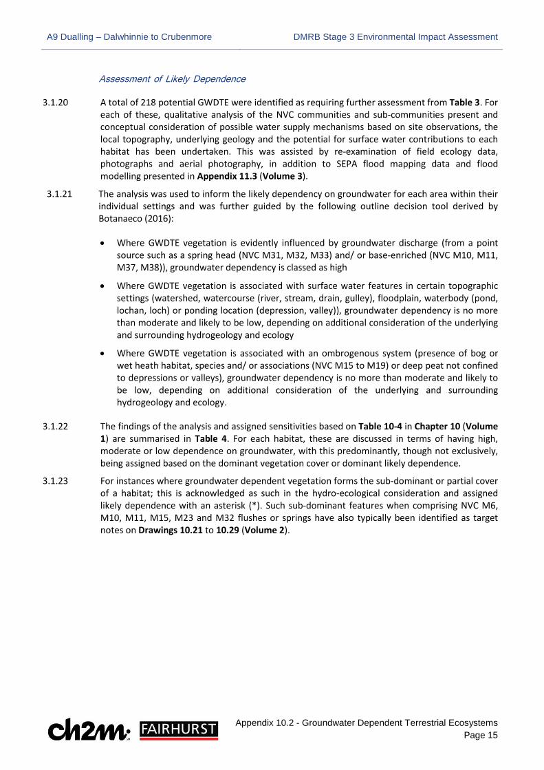
3.1.20 A total of 218 potential GWDTE were identified as requiring further assessment from Table 3. For each of these, qualitative analysis of the NVC communities and sub-communities present and conceptual consideration of possible water supply mechanisms based on site observations, the local topography, underlying geology and the potential for surface water contributions to each habitat has been undertaken. This was assisted by re-examination of field ecology data, photographs and aerial photography, in addition to SEPA flood mapping data and flood modelling presented in Appendix 11.3 (Volume 3).
3.1.21 The analysis was used to inform the likely dependency on groundwater for each area within their individual settings and was further guided by the following outline decision tool derived by Botanaeco (2016): • Where GWDTE vegetation is evidently influenced by groundwater discharge (from a point
source such as a spring head (NVC M31, M32, M33) and/ or base-enriched (NVC M10, M11, M37, M38)), groundwater dependency is classed as high
• Where GWDTE vegetation is associated with surface water features in certain topographic settings (watershed, watercourse (river, stream, drain, gulley), floodplain, waterbody (pond, lochan, loch) or ponding location (depression, valley)), groundwater dependency is no more than moderate and likely to be low, depending on additional consideration of the underlying and surrounding hydrogeology and ecology
• Where GWDTE vegetation is associated with an ombrogenous system (presence of bog or wet heath habitat, species and/ or associations (NVC M15 to M19) or deep peat not confined to depressions or valleys), groundwater dependency is no more than moderate and likely to be low, depending on additional consideration of the underlying and surrounding hydrogeology and ecology.
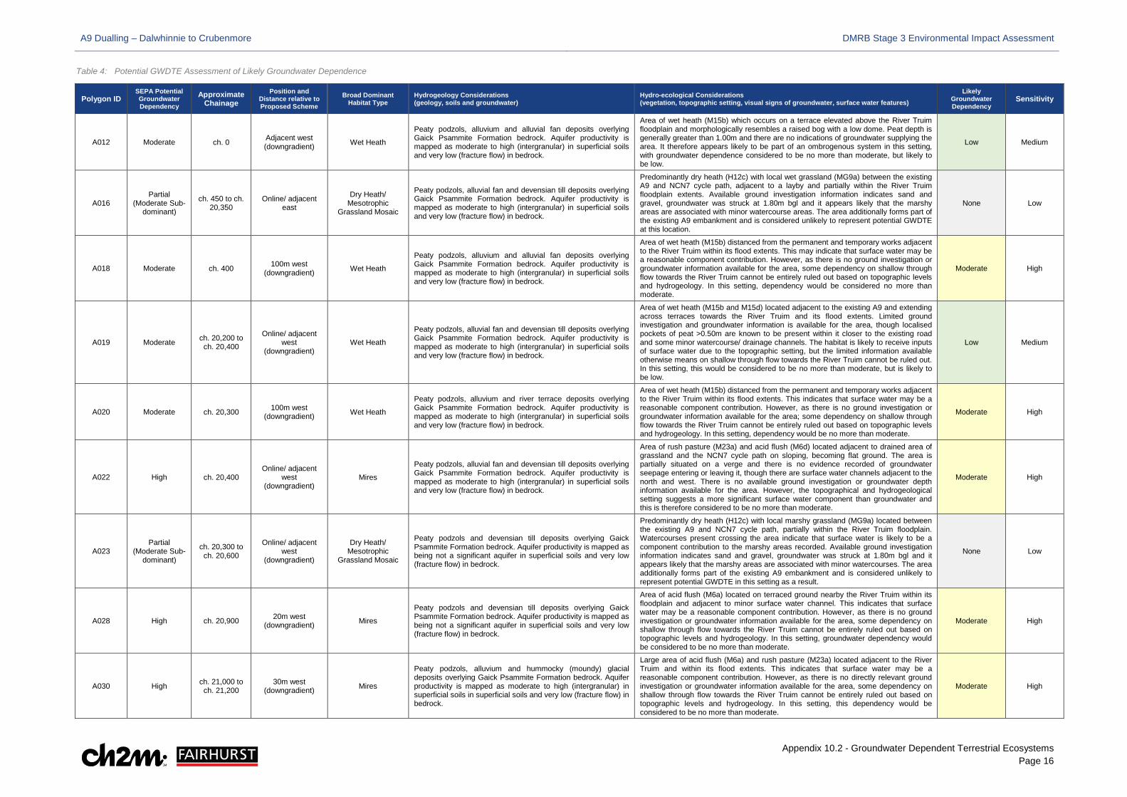
3.1.22 The findings of the analysis and assigned sensitivities based on Table 10-4 in Chapter 10 (Volume
1) are summarised in Table 4. For each habitat, these are discussed in terms of having high, moderate or low dependence on groundwater, with this predominantly, though not exclusively, being assigned based on the dominant vegetation cover or dominant likely dependence.
3.1.23 For instances where groundwater dependent vegetation forms the sub-dominant or partial cover of a habitat; this is acknowledged as such in the hydro-ecological consideration and assigned likely dependence with an asterisk (*). Such sub-dominant features when comprising NVC M6, M10, M11, M15, M23 and M32 flushes or springs have also typically been identified as target notes on Drawings 10.21 to 10.29 (Volume 2).
A9 Dualling – Dalwhinnie to Crubenmore DMRB Stage 3 Environmental Impact Assessment
Appendix 10.2 - Groundwater Dependent Terrestrial Ecosystems Page 16
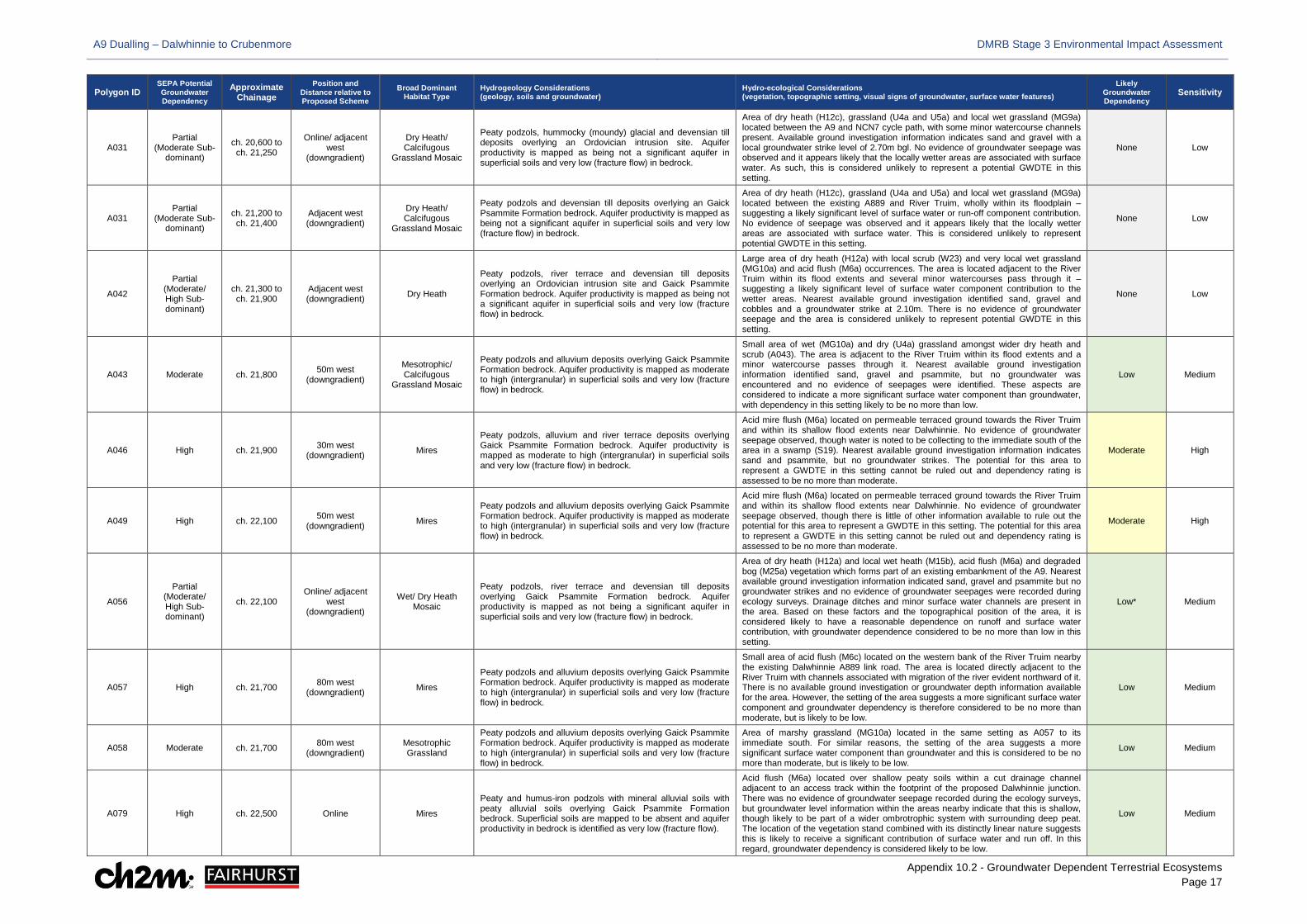
Table 4: Potential GWDTE Assessment of Likely Groundwater Dependence
Polygon ID SEPA Potential Groundwater Dependency
Approximate Chainage
Position and Distance relative to Proposed Scheme
Broad Dominant Habitat Type
Hydrogeology Considerations (geology, soils and groundwater)
Hydro-ecological Considerations (vegetation, topographic setting, visual signs of groundwater, surface water features)
Likely Groundwater Dependency
Sensitivity
A012 Moderate ch. 0 Adjacent west (downgradient) Wet Heath
Peaty podzols, alluvium and alluvial fan deposits overlying Gaick Psammite Formation bedrock. Aquifer productivity is mapped as moderate to high (intergranular) in superficial soils and very low (fracture flow) in bedrock.
Area of wet heath (M15b) which occurs on a terrace elevated above the River Truim floodplain and morphologically resembles a raised bog with a low dome. Peat depth is generally greater than 1.00m and there are no indications of groundwater supplying the area. It therefore appears likely to be part of an ombrogenous system in this setting, with groundwater dependence considered to be no more than moderate, but likely to be low.
Low Medium
A016 Partial
(Moderate Sub-dominant)
ch. 450 to ch. 20,350
Online/ adjacent east
Dry Heath/ Mesotrophic
Grassland Mosaic
Peaty podzols, alluvial fan and devensian till deposits overlying Gaick Psammite Formation bedrock. Aquifer productivity is mapped as moderate to high (intergranular) in superficial soils and very low (fracture flow) in bedrock.
Predominantly dry heath (H12c) with local wet grassland (MG9a) between the existing A9 and NCN7 cycle path, adjacent to a layby and partially within the River Truim floodplain extents. Available ground investigation information indicates sand and gravel, groundwater was struck at 1.80m bgl and it appears likely that the marshy areas are associated with minor watercourse areas. The area additionally forms part of the existing A9 embankment and is considered unlikely to represent potential GWDTE at this location.
None Low
A018 Moderate ch. 400 100m west (downgradient) Wet Heath
Peaty podzols, alluvium and alluvial fan deposits overlying Gaick Psammite Formation bedrock. Aquifer productivity is mapped as moderate to high (intergranular) in superficial soils and very low (fracture flow) in bedrock.
Area of wet heath (M15b) distanced from the permanent and temporary works adjacent to the River Truim within its flood extents. This may indicate that surface water may be a reasonable component contribution. However, as there is no ground investigation or groundwater information available for the area, some dependency on shallow through flow towards the River Truim cannot be entirely ruled out based on topographic levels and hydrogeology. In this setting, dependency would be considered no more than moderate.
Moderate High
A019 Moderate ch. 20,200 to ch. 20,400
Online/ adjacent west
(downgradient) Wet Heath
Peaty podzols, alluvial fan and devensian till deposits overlying Gaick Psammite Formation bedrock. Aquifer productivity is mapped as moderate to high (intergranular) in superficial soils and very low (fracture flow) in bedrock.
Area of wet heath (M15b and M15d) located adjacent to the existing A9 and extending across terraces towards the River Truim and its flood extents. Limited ground investigation and groundwater information is available for the area, though localised pockets of peat >0.50m are known to be present within it closer to the existing road and some minor watercourse/ drainage channels. The habitat is likely to receive inputs of surface water due to the topographic setting, but the limited information available otherwise means on shallow through flow towards the River Truim cannot be ruled out. In this setting, this would be considered to be no more than moderate, but is likely to be low.
Low Medium
A020 Moderate ch. 20,300 100m west (downgradient) Wet Heath
Peaty podzols, alluvium and river terrace deposits overlying Gaick Psammite Formation bedrock. Aquifer productivity is mapped as moderate to high (intergranular) in superficial soils and very low (fracture flow) in bedrock.
Area of wet heath (M15b) distanced from the permanent and temporary works adjacent to the River Truim within its flood extents. This indicates that surface water may be a reasonable component contribution. However, as there is no ground investigation or groundwater information available for the area; some dependency on shallow through flow towards the River Truim cannot be entirely ruled out based on topographic levels and hydrogeology. In this setting, dependency would be no more than moderate.
Moderate High
A022 High ch. 20,400 Online/ adjacent
west (downgradient)
Mires
Peaty podzols, alluvial fan and devensian till deposits overlying Gaick Psammite Formation bedrock. Aquifer productivity is mapped as moderate to high (intergranular) in superficial soils and very low (fracture flow) in bedrock.
Area of rush pasture (M23a) and acid flush (M6d) located adjacent to drained area of grassland and the NCN7 cycle path on sloping, becoming flat ground. The area is partially situated on a verge and there is no evidence recorded of groundwater seepage entering or leaving it, though there are surface water channels adjacent to the north and west. There is no available ground investigation or groundwater depth information available for the area. However, the topographical and hydrogeological setting suggests a more significant surface water component than groundwater and this is therefore considered to be no more than moderate.
Moderate High
A023 Partial
(Moderate Sub-dominant)
ch. 20,300 to ch. 20,600
Online/ adjacent west
(downgradient)
Dry Heath/ Mesotrophic
Grassland Mosaic
Peaty podzols and devensian till deposits overlying Gaick Psammite Formation bedrock. Aquifer productivity is mapped as being not a significant aquifer in superficial soils and very low (fracture flow) in bedrock.
Predominantly dry heath (H12c) with local marshy grassland (MG9a) located between the existing A9 and NCN7 cycle path, partially within the River Truim floodplain. Watercourses present crossing the area indicate that surface water is likely to be a component contribution to the marshy areas recorded. Available ground investigation information indicates sand and gravel, groundwater was struck at 1.80m bgl and it appears likely that the marshy areas are associated with minor watercourses. The area additionally forms part of the existing A9 embankment and is considered unlikely to represent potential GWDTE in this setting as a result.
None Low
A028 High ch. 20,900 20m west (downgradient) Mires
Peaty podzols and devensian till deposits overlying Gaick Psammite Formation bedrock. Aquifer productivity is mapped as being not a significant aquifer in superficial soils and very low (fracture flow) in bedrock.
Area of acid flush (M6a) located on terraced ground nearby the River Truim within its floodplain and adjacent to minor surface water channel. This indicates that surface water may be a reasonable component contribution. However, as there is no ground investigation or groundwater information available for the area, some dependency on shallow through flow towards the River Truim cannot be entirely ruled out based on topographic levels and hydrogeology. In this setting, groundwater dependency would be considered to be no more than moderate.
Moderate High
A030 High ch. 21,000 to ch. 21,200
30m west (downgradient) Mires
Peaty podzols, alluvium and hummocky (moundy) glacial deposits overlying Gaick Psammite Formation bedrock. Aquifer productivity is mapped as moderate to high (intergranular) in superficial soils in superficial soils and very low (fracture flow) in bedrock.
Large area of acid flush (M6a) and rush pasture (M23a) located adjacent to the River Truim and within its flood extents. This indicates that surface water may be a reasonable component contribution. However, as there is no directly relevant ground investigation or groundwater information available for the area, some dependency on shallow through flow towards the River Truim cannot be entirely ruled out based on topographic levels and hydrogeology. In this setting, this dependency would be considered to be no more than moderate.
Moderate High
A9 Dualling – Dalwhinnie to Crubenmore DMRB Stage 3 Environmental Impact Assessment
Appendix 10.2 - Groundwater Dependent Terrestrial Ecosystems Page 17
Polygon ID SEPA Potential Groundwater Dependency
Approximate Chainage
Position and Distance relative to Proposed Scheme
Broad Dominant Habitat Type
Hydrogeology Considerations (geology, soils and groundwater)
Hydro-ecological Considerations (vegetation, topographic setting, visual signs of groundwater, surface water features)
Likely Groundwater Dependency
Sensitivity
A031 Partial
(Moderate Sub-dominant)
ch. 20,600 to ch. 21,250
Online/ adjacent west
(downgradient)
Dry Heath/ Calcifugous
Grassland Mosaic
Peaty podzols, hummocky (moundy) glacial and devensian till deposits overlying an Ordovician intrusion site. Aquifer productivity is mapped as being not a significant aquifer in superficial soils and very low (fracture flow) in bedrock.
Area of dry heath (H12c), grassland (U4a and U5a) and local wet grassland (MG9a) located between the A9 and NCN7 cycle path, with some minor watercourse channels present. Available ground investigation information indicates sand and gravel with a local groundwater strike level of 2.70m bgl. No evidence of groundwater seepage was observed and it appears likely that the locally wetter areas are associated with surface water. As such, this is considered unlikely to represent a potential GWDTE in this setting.
None Low
A031 Partial
(Moderate Sub-dominant)
ch. 21,200 to ch. 21,400
Adjacent west (downgradient)
Dry Heath/ Calcifugous
Grassland Mosaic
Peaty podzols and devensian till deposits overlying an Gaick Psammite Formation bedrock. Aquifer productivity is mapped as being not a significant aquifer in superficial soils and very low (fracture flow) in bedrock.
Area of dry heath (H12c), grassland (U4a and U5a) and local wet grassland (MG9a) located between the existing A889 and River Truim, wholly within its floodplain – suggesting a likely significant level of surface water or run-off component contribution. No evidence of seepage was observed and it appears likely that the locally wetter areas are associated with surface water. This is considered unlikely to represent potential GWDTE in this setting.
None Low
A042
Partial (Moderate/ High Sub-dominant)
ch. 21,300 to ch. 21,900
Adjacent west (downgradient) Dry Heath
Peaty podzols, river terrace and devensian till deposits overlying an Ordovician intrusion site and Gaick Psammite Formation bedrock. Aquifer productivity is mapped as being not a significant aquifer in superficial soils and very low (fracture flow) in bedrock.
Large area of dry heath (H12a) with local scrub (W23) and very local wet grassland (MG10a) and acid flush (M6a) occurrences. The area is located adjacent to the River Truim within its flood extents and several minor watercourses pass through it – suggesting a likely significant level of surface water component contribution to the wetter areas. Nearest available ground investigation identified sand, gravel and cobbles and a groundwater strike at 2.10m. There is no evidence of groundwater seepage and the area is considered unlikely to represent potential GWDTE in this setting.
None Low
A043 Moderate ch. 21,800 50m west (downgradient)
Mesotrophic/ Calcifugous
Grassland Mosaic
Peaty podzols and alluvium deposits overlying Gaick Psammite Formation bedrock. Aquifer productivity is mapped as moderate to high (intergranular) in superficial soils and very low (fracture flow) in bedrock.
Small area of wet (MG10a) and dry (U4a) grassland amongst wider dry heath and scrub (A043). The area is adjacent to the River Truim within its flood extents and a minor watercourse passes through it. Nearest available ground investigation information identified sand, gravel and psammite, but no groundwater was encountered and no evidence of seepages were identified. These aspects are considered to indicate a more significant surface water component than groundwater, with dependency in this setting likely to be no more than low.
Low Medium
A046 High ch. 21,900 30m west (downgradient) Mires
Peaty podzols, alluvium and river terrace deposits overlying Gaick Psammite Formation bedrock. Aquifer productivity is mapped as moderate to high (intergranular) in superficial soils and very low (fracture flow) in bedrock.
Acid mire flush (M6a) located on permeable terraced ground towards the River Truim and within its shallow flood extents near Dalwhinnie. No evidence of groundwater seepage observed, though water is noted to be collecting to the immediate south of the area in a swamp (S19). Nearest available ground investigation information indicates sand and psammite, but no groundwater strikes. The potential for this area to represent a GWDTE in this setting cannot be ruled out and dependency rating is assessed to be no more than moderate.
Moderate High
A049 High ch. 22,100 50m west (downgradient) Mires
Peaty podzols and alluvium deposits overlying Gaick Psammite Formation bedrock. Aquifer productivity is mapped as moderate to high (intergranular) in superficial soils and very low (fracture flow) in bedrock.
Acid mire flush (M6a) located on permeable terraced ground towards the River Truim and within its shallow flood extents near Dalwhinnie. No evidence of groundwater seepage observed, though there is little of other information available to rule out the potential for this area to represent a GWDTE in this setting. The potential for this area to represent a GWDTE in this setting cannot be ruled out and dependency rating is assessed to be no more than moderate.
Moderate High
A056
Partial (Moderate/ High Sub-dominant)
ch. 22,100 Online/ adjacent
west (downgradient)
Wet/ Dry Heath Mosaic
Peaty podzols, river terrace and devensian till deposits overlying Gaick Psammite Formation bedrock. Aquifer productivity is mapped as not being a significant aquifer in superficial soils and very low (fracture flow) in bedrock.
Area of dry heath (H12a) and local wet heath (M15b), acid flush (M6a) and degraded bog (M25a) vegetation which forms part of an existing embankment of the A9. Nearest available ground investigation information indicated sand, gravel and psammite but no groundwater strikes and no evidence of groundwater seepages were recorded during ecology surveys. Drainage ditches and minor surface water channels are present in the area. Based on these factors and the topographical position of the area, it is considered likely to have a reasonable dependence on runoff and surface water contribution, with groundwater dependence considered to be no more than low in this setting.
Low* Medium
A057 High ch. 21,700 80m west (downgradient) Mires
Peaty podzols and alluvium deposits overlying Gaick Psammite Formation bedrock. Aquifer productivity is mapped as moderate to high (intergranular) in superficial soils and very low (fracture flow) in bedrock.
Small area of acid flush (M6c) located on the western bank of the River Truim nearby the existing Dalwhinnie A889 link road. The area is located directly adjacent to the River Truim with channels associated with migration of the river evident northward of it. There is no available ground investigation or groundwater depth information available for the area. However, the setting of the area suggests a more significant surface water component and groundwater dependency is therefore considered to be no more than moderate, but is likely to be low.
Low Medium
A058 Moderate ch. 21,700 80m west (downgradient)
Mesotrophic Grassland
Peaty podzols and alluvium deposits overlying Gaick Psammite Formation bedrock. Aquifer productivity is mapped as moderate to high (intergranular) in superficial soils and very low (fracture flow) in bedrock.
Area of marshy grassland (MG10a) located in the same setting as A057 to its immediate south. For similar reasons, the setting of the area suggests a more significant surface water component than groundwater and this is considered to be no more than moderate, but is likely to be low.
Low Medium
A079 High ch. 22,500 Online Mires
Peaty and humus-iron podzols with mineral alluvial soils with peaty alluvial soils overlying Gaick Psammite Formation bedrock. Superficial soils are mapped to be absent and aquifer productivity in bedrock is identified as very low (fracture flow).
Acid flush (M6a) located over shallow peaty soils within a cut drainage channel adjacent to an access track within the footprint of the proposed Dalwhinnie junction. There was no evidence of groundwater seepage recorded during the ecology surveys, but groundwater level information within the areas nearby indicate that this is shallow, though likely to be part of a wider ombrotrophic system with surrounding deep peat. The location of the vegetation stand combined with its distinctly linear nature suggests this is likely to receive a significant contribution of surface water and run off. In this regard, groundwater dependency is considered likely to be low.
Low Medium
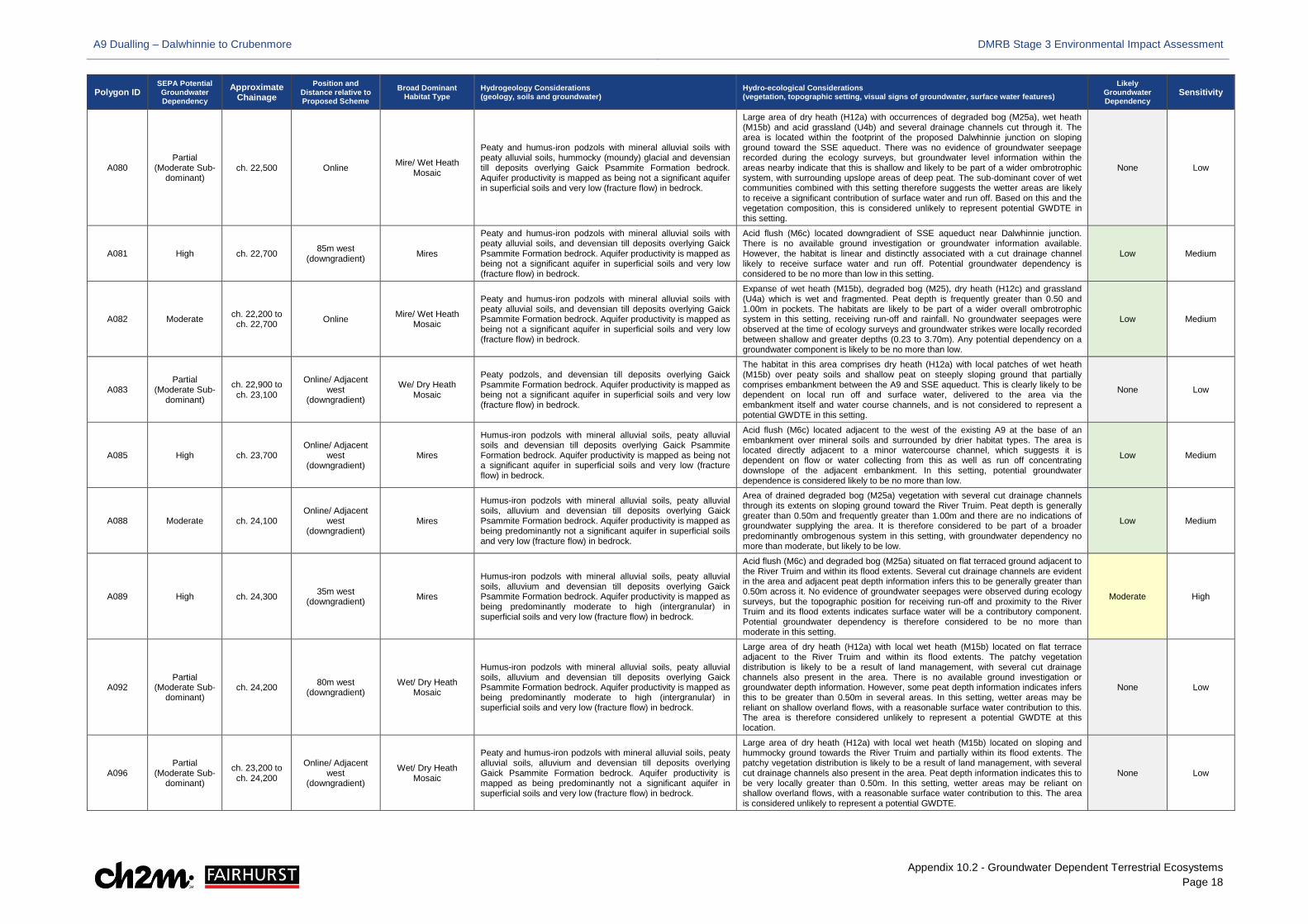
A9 Dualling – Dalwhinnie to Crubenmore DMRB Stage 3 Environmental Impact Assessment
Appendix 10.2 - Groundwater Dependent Terrestrial Ecosystems Page 18
Polygon ID SEPA Potential Groundwater Dependency
Approximate Chainage
Position and Distance relative to Proposed Scheme
Broad Dominant Habitat Type
Hydrogeology Considerations (geology, soils and groundwater)
Hydro-ecological Considerations (vegetation, topographic setting, visual signs of groundwater, surface water features)
Likely Groundwater Dependency
Sensitivity
A080 Partial
(Moderate Sub-dominant)
ch. 22,500 Online Mire/ Wet Heath Mosaic
Peaty and humus-iron podzols with mineral alluvial soils with peaty alluvial soils, hummocky (moundy) glacial and devensian till deposits overlying Gaick Psammite Formation bedrock. Aquifer productivity is mapped as being not a significant aquifer in superficial soils and very low (fracture flow) in bedrock.
Large area of dry heath (H12a) with occurrences of degraded bog (M25a), wet heath (M15b) and acid grassland (U4b) and several drainage channels cut through it. The area is located within the footprint of the proposed Dalwhinnie junction on sloping ground toward the SSE aqueduct. There was no evidence of groundwater seepage recorded during the ecology surveys, but groundwater level information within the areas nearby indicate that this is shallow and likely to be part of a wider ombrotrophic system, with surrounding upslope areas of deep peat. The sub-dominant cover of wet communities combined with this setting therefore suggests the wetter areas are likely to receive a significant contribution of surface water and run off. Based on this and the vegetation composition, this is considered unlikely to represent potential GWDTE in this setting.
None Low
A081 High ch. 22,700 85m west (downgradient) Mires
Peaty and humus-iron podzols with mineral alluvial soils with peaty alluvial soils, and devensian till deposits overlying Gaick Psammite Formation bedrock. Aquifer productivity is mapped as being not a significant aquifer in superficial soils and very low (fracture flow) in bedrock.
Acid flush (M6c) located downgradient of SSE aqueduct near Dalwhinnie junction. There is no available ground investigation or groundwater information available. However, the habitat is linear and distinctly associated with a cut drainage channel likely to receive surface water and run off. Potential groundwater dependency is considered to be no more than low in this setting.
Low Medium
A082 Moderate ch. 22,200 to ch. 22,700 Online Mire/ Wet Heath
Mosaic
Peaty and humus-iron podzols with mineral alluvial soils with peaty alluvial soils, and devensian till deposits overlying Gaick Psammite Formation bedrock. Aquifer productivity is mapped as being not a significant aquifer in superficial soils and very low (fracture flow) in bedrock.
Expanse of wet heath (M15b), degraded bog (M25), dry heath (H12c) and grassland (U4a) which is wet and fragmented. Peat depth is frequently greater than 0.50 and 1.00m in pockets. The habitats are likely to be part of a wider overall ombrotrophic system in this setting, receiving run-off and rainfall. No groundwater seepages were observed at the time of ecology surveys and groundwater strikes were locally recorded between shallow and greater depths (0.23 to 3.70m). Any potential dependency on a groundwater component is likely to be no more than low.
Low Medium
A083 Partial
(Moderate Sub-dominant)
ch. 22,900 to ch. 23,100
Online/ Adjacent west
(downgradient)
We/ Dry Heath Mosaic
Peaty podzols, and devensian till deposits overlying Gaick Psammite Formation bedrock. Aquifer productivity is mapped as being not a significant aquifer in superficial soils and very low (fracture flow) in bedrock.
The habitat in this area comprises dry heath (H12a) with local patches of wet heath (M15b) over peaty soils and shallow peat on steeply sloping ground that partially comprises embankment between the A9 and SSE aqueduct. This is clearly likely to be dependent on local run off and surface water, delivered to the area via the embankment itself and water course channels, and is not considered to represent a potential GWDTE in this setting.
None Low
A085 High ch. 23,700 Online/ Adjacent
west (downgradient)
Mires
Humus-iron podzols with mineral alluvial soils, peaty alluvial soils and devensian till deposits overlying Gaick Psammite Formation bedrock. Aquifer productivity is mapped as being not a significant aquifer in superficial soils and very low (fracture flow) in bedrock.
Acid flush (M6c) located adjacent to the west of the existing A9 at the base of an embankment over mineral soils and surrounded by drier habitat types. The area is located directly adjacent to a minor watercourse channel, which suggests it is dependent on flow or water collecting from this as well as run off concentrating downslope of the adjacent embankment. In this setting, potential groundwater dependence is considered likely to be no more than low.
Low Medium
A088 Moderate ch. 24,100 Online/ Adjacent
west (downgradient)
Mires
Humus-iron podzols with mineral alluvial soils, peaty alluvial soils, alluvium and devensian till deposits overlying Gaick Psammite Formation bedrock. Aquifer productivity is mapped as being predominantly not a significant aquifer in superficial soils and very low (fracture flow) in bedrock.
Area of drained degraded bog (M25a) vegetation with several cut drainage channels through its extents on sloping ground toward the River Truim. Peat depth is generally greater than 0.50m and frequently greater than 1.00m and there are no indications of groundwater supplying the area. It is therefore considered to be part of a broader predominantly ombrogenous system in this setting, with groundwater dependency no more than moderate, but likely to be low.
Low Medium
A089 High ch. 24,300 35m west (downgradient) Mires
Humus-iron podzols with mineral alluvial soils, peaty alluvial soils, alluvium and devensian till deposits overlying Gaick Psammite Formation bedrock. Aquifer productivity is mapped as being predominantly moderate to high (intergranular) in superficial soils and very low (fracture flow) in bedrock.
Acid flush (M6c) and degraded bog (M25a) situated on flat terraced ground adjacent to the River Truim and within its flood extents. Several cut drainage channels are evident in the area and adjacent peat depth information infers this to be generally greater than 0.50m across it. No evidence of groundwater seepages were observed during ecology surveys, but the topographic position for receiving run-off and proximity to the River Truim and its flood extents indicates surface water will be a contributory component. Potential groundwater dependency is therefore considered to be no more than moderate in this setting.
Moderate High
A092 Partial
(Moderate Sub-dominant)
ch. 24,200 80m west (downgradient)
Wet/ Dry Heath Mosaic
Humus-iron podzols with mineral alluvial soils, peaty alluvial soils, alluvium and devensian till deposits overlying Gaick Psammite Formation bedrock. Aquifer productivity is mapped as being predominantly moderate to high (intergranular) in superficial soils and very low (fracture flow) in bedrock.
Large area of dry heath (H12a) with local wet heath (M15b) located on flat terrace adjacent to the River Truim and within its flood extents. The patchy vegetation distribution is likely to be a result of land management, with several cut drainage channels also present in the area. There is no available ground investigation or groundwater depth information. However, some peat depth information indicates infers this to be greater than 0.50m in several areas. In this setting, wetter areas may be reliant on shallow overland flows, with a reasonable surface water contribution to this. The area is therefore considered unlikely to represent a potential GWDTE at this location.
None Low
A096 Partial
(Moderate Sub-dominant)
ch. 23,200 to ch. 24,200
Online/ Adjacent west
(downgradient)
Wet/ Dry Heath Mosaic
Peaty and humus-iron podzols with mineral alluvial soils, peaty alluvial soils, alluvium and devensian till deposits overlying Gaick Psammite Formation bedrock. Aquifer productivity is mapped as being predominantly not a significant aquifer in superficial soils and very low (fracture flow) in bedrock.
Large area of dry heath (H12a) with local wet heath (M15b) located on sloping and hummocky ground towards the River Truim and partially within its flood extents. The patchy vegetation distribution is likely to be a result of land management, with several cut drainage channels also present in the area. Peat depth information indicates this to be very locally greater than 0.50m. In this setting, wetter areas may be reliant on shallow overland flows, with a reasonable surface water contribution to this. The area is considered unlikely to represent a potential GWDTE.
None Low
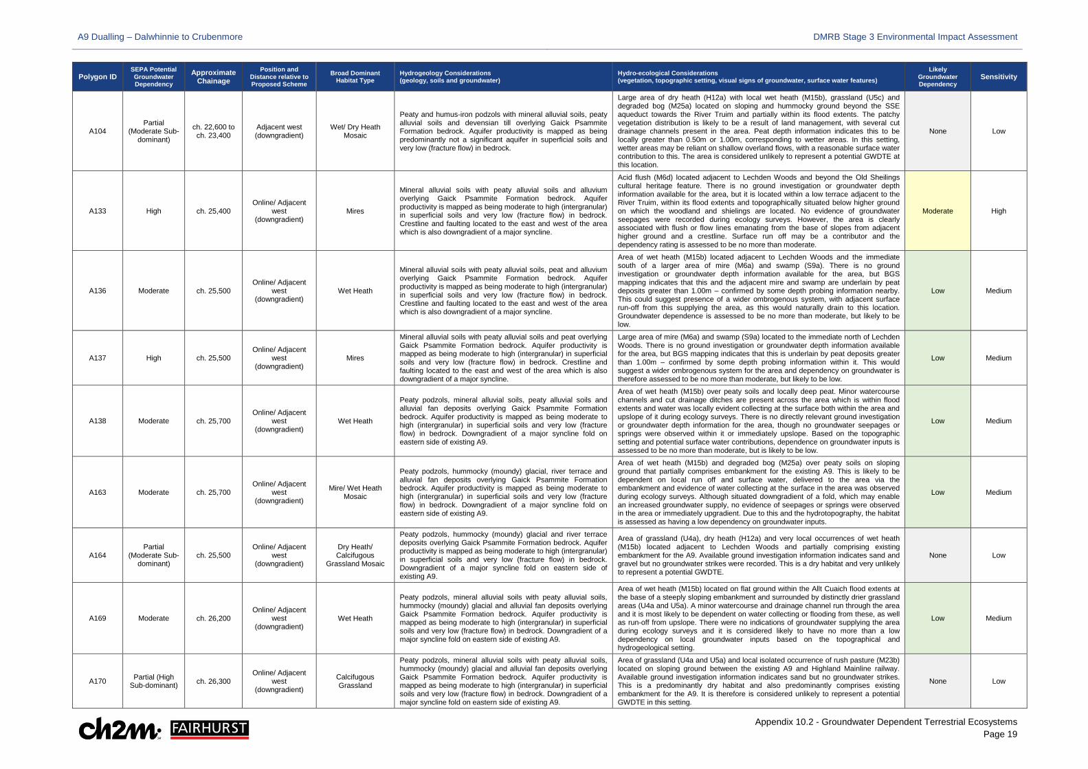
A9 Dualling – Dalwhinnie to Crubenmore DMRB Stage 3 Environmental Impact Assessment
Appendix 10.2 - Groundwater Dependent Terrestrial Ecosystems Page 19
Polygon ID SEPA Potential Groundwater Dependency
Approximate Chainage
Position and Distance relative to Proposed Scheme
Broad Dominant Habitat Type
Hydrogeology Considerations (geology, soils and groundwater)
Hydro-ecological Considerations (vegetation, topographic setting, visual signs of groundwater, surface water features)
Likely Groundwater Dependency
Sensitivity
A104 Partial
(Moderate Sub-dominant)
ch. 22,600 to ch. 23,400
Adjacent west (downgradient)
Wet/ Dry Heath Mosaic
Peaty and humus-iron podzols with mineral alluvial soils, peaty alluvial soils and devensian till overlying Gaick Psammite Formation bedrock. Aquifer productivity is mapped as being predominantly not a significant aquifer in superficial soils and very low (fracture flow) in bedrock.
Large area of dry heath (H12a) with local wet heath (M15b), grassland (U5c) and degraded bog (M25a) located on sloping and hummocky ground beyond the SSE aqueduct towards the River Truim and partially within its flood extents. The patchy vegetation distribution is likely to be a result of land management, with several cut drainage channels present in the area. Peat depth information indicates this to be locally greater than 0.50m or 1.00m, corresponding to wetter areas. In this setting, wetter areas may be reliant on shallow overland flows, with a reasonable surface water contribution to this. The area is considered unlikely to represent a potential GWDTE at this location.
None Low
A133 High ch. 25,400 Online/ Adjacent
west (downgradient)
Mires
Mineral alluvial soils with peaty alluvial soils and alluvium overlying Gaick Psammite Formation bedrock. Aquifer productivity is mapped as being moderate to high (intergranular) in superficial soils and very low (fracture flow) in bedrock. Crestline and faulting located to the east and west of the area which is also downgradient of a major syncline.
Acid flush (M6d) located adjacent to Lechden Woods and beyond the Old Sheilings cultural heritage feature. There is no ground investigation or groundwater depth information available for the area, but it is located within a low terrace adjacent to the River Truim, within its flood extents and topographically situated below higher ground on which the woodland and shielings are located. No evidence of groundwater seepages were recorded during ecology surveys. However, the area is clearly associated with flush or flow lines emanating from the base of slopes from adjacent higher ground and a crestline. Surface run off may be a contributor and the dependency rating is assessed to be no more than moderate.
Moderate High
A136 Moderate ch. 25,500 Online/ Adjacent
west (downgradient)
Wet Heath
Mineral alluvial soils with peaty alluvial soils, peat and alluvium overlying Gaick Psammite Formation bedrock. Aquifer productivity is mapped as being moderate to high (intergranular) in superficial soils and very low (fracture flow) in bedrock. Crestline and faulting located to the east and west of the area which is also downgradient of a major syncline.
Area of wet heath (M15b) located adjacent to Lechden Woods and the immediate south of a larger area of mire (M6a) and swamp (S9a). There is no ground investigation or groundwater depth information available for the area, but BGS mapping indicates that this and the adjacent mire and swamp are underlain by peat deposits greater than 1.00m – confirmed by some depth probing information nearby. This could suggest presence of a wider ombrogenous system, with adjacent surface run-off from this supplying the area, as this would naturally drain to this location. Groundwater dependence is assessed to be no more than moderate, but likely to be low.
Low Medium
A137 High ch. 25,500 Online/ Adjacent
west (downgradient)
Mires
Mineral alluvial soils with peaty alluvial soils and peat overlying Gaick Psammite Formation bedrock. Aquifer productivity is mapped as being moderate to high (intergranular) in superficial soils and very low (fracture flow) in bedrock. Crestline and faulting located to the east and west of the area which is also downgradient of a major syncline.
Large area of mire (M6a) and swamp (S9a) located to the immediate north of Lechden Woods. There is no ground investigation or groundwater depth information available for the area, but BGS mapping indicates that this is underlain by peat deposits greater than 1.00m – confirmed by some depth probing information within it. This would suggest a wider ombrogenous system for the area and dependency on groundwater is therefore assessed to be no more than moderate, but likely to be low.
Low Medium
A138 Moderate ch. 25,700 Online/ Adjacent
west (downgradient)
Wet Heath
Peaty podzols, mineral alluvial soils, peaty alluvial soils and alluvial fan deposits overlying Gaick Psammite Formation bedrock. Aquifer productivity is mapped as being moderate to high (intergranular) in superficial soils and very low (fracture flow) in bedrock. Downgradient of a major syncline fold on eastern side of existing A9.
Area of wet heath (M15b) over peaty soils and locally deep peat. Minor watercourse channels and cut drainage ditches are present across the area which is within flood extents and water was locally evident collecting at the surface both within the area and upslope of it during ecology surveys. There is no directly relevant ground investigation or groundwater depth information for the area, though no groundwater seepages or springs were observed within it or immediately upslope. Based on the topographic setting and potential surface water contributions, dependence on groundwater inputs is assessed to be no more than moderate, but is likely to be low.
Low Medium
A163 Moderate ch. 25,700 Online/ Adjacent
west (downgradient)
Mire/ Wet Heath Mosaic
Peaty podzols, hummocky (moundy) glacial, river terrace and alluvial fan deposits overlying Gaick Psammite Formation bedrock. Aquifer productivity is mapped as being moderate to high (intergranular) in superficial soils and very low (fracture flow) in bedrock. Downgradient of a major syncline fold on eastern side of existing A9.
Area of wet heath (M15b) and degraded bog (M25a) over peaty soils on sloping ground that partially comprises embankment for the existing A9. This is likely to be dependent on local run off and surface water, delivered to the area via the embankment and evidence of water collecting at the surface in the area was observed during ecology surveys. Although situated downgradient of a fold, which may enable an increased groundwater supply, no evidence of seepages or springs were observed in the area or immediately upgradient. Due to this and the hydrotopography, the habitat is assessed as having a low dependency on groundwater inputs.
Low Medium
A164 Partial
(Moderate Sub-dominant)
ch. 25,500 Online/ Adjacent
west (downgradient)
Dry Heath/ Calcifugous
Grassland Mosaic
Peaty podzols, hummocky (moundy) glacial and river terrace deposits overlying Gaick Psammite Formation bedrock. Aquifer productivity is mapped as being moderate to high (intergranular) in superficial soils and very low (fracture flow) in bedrock. Downgradient of a major syncline fold on eastern side of existing A9.
Area of grassland (U4a), dry heath (H12a) and very local occurrences of wet heath (M15b) located adjacent to Lechden Woods and partially comprising existing embankment for the A9. Available ground investigation information indicates sand and gravel but no groundwater strikes were recorded. This is a dry habitat and very unlikely to represent a potential GWDTE.
None Low
A169 Moderate ch. 26,200 Online/ Adjacent
west (downgradient)
Wet Heath
Peaty podzols, mineral alluvial soils with peaty alluvial soils, hummocky (moundy) glacial and alluvial fan deposits overlying Gaick Psammite Formation bedrock. Aquifer productivity is mapped as being moderate to high (intergranular) in superficial soils and very low (fracture flow) in bedrock. Downgradient of a major syncline fold on eastern side of existing A9.
Area of wet heath (M15b) located on flat ground within the Allt Cuaich flood extents at the base of a steeply sloping embankment and surrounded by distinctly drier grassland areas (U4a and U5a). A minor watercourse and drainage channel run through the area and it is most likely to be dependent on water collecting or flooding from these, as well as run-off from upslope. There were no indications of groundwater supplying the area during ecology surveys and it is considered likely to have no more than a low dependency on local groundwater inputs based on the topographical and hydrogeological setting.
Low Medium
A170 Partial (High Sub-dominant) ch. 26,300
Online/ Adjacent west
(downgradient)
Calcifugous Grassland
Peaty podzols, mineral alluvial soils with peaty alluvial soils, hummocky (moundy) glacial and alluvial fan deposits overlying Gaick Psammite Formation bedrock. Aquifer productivity is mapped as being moderate to high (intergranular) in superficial soils and very low (fracture flow) in bedrock. Downgradient of a major syncline fold on eastern side of existing A9.
Area of grassland (U4a and U5a) and local isolated occurrence of rush pasture (M23b) located on sloping ground between the existing A9 and Highland Mainline railway. Available ground investigation information indicates sand but no groundwater strikes. This is a predominantly dry habitat and also predominantly comprises existing embankment for the A9. It is therefore is considered unlikely to represent a potential GWDTE in this setting.
None Low
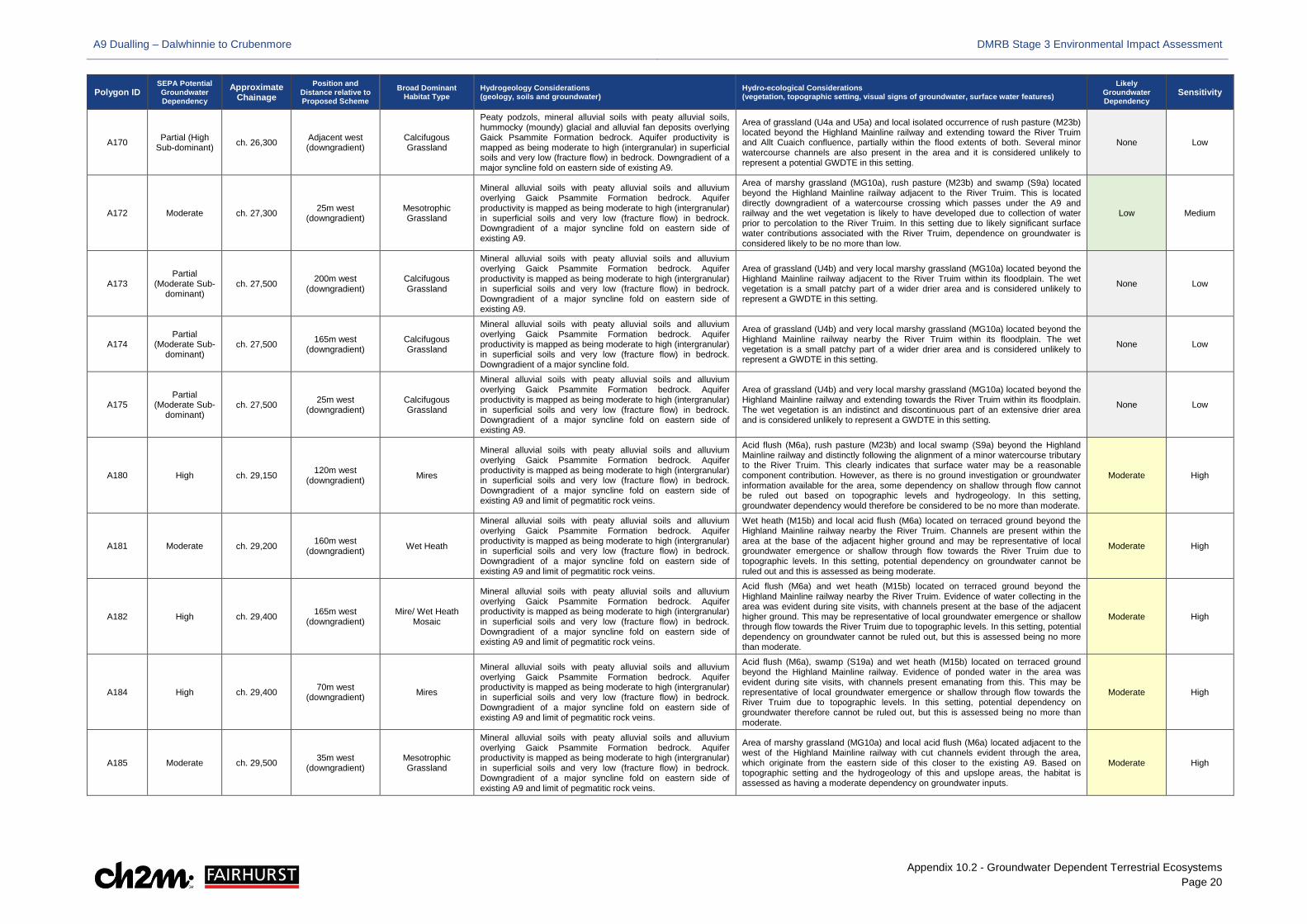
A9 Dualling – Dalwhinnie to Crubenmore DMRB Stage 3 Environmental Impact Assessment
Appendix 10.2 - Groundwater Dependent Terrestrial Ecosystems Page 20
Polygon ID SEPA Potential Groundwater Dependency
Approximate Chainage
Position and Distance relative to Proposed Scheme
Broad Dominant Habitat Type
Hydrogeology Considerations (geology, soils and groundwater)
Hydro-ecological Considerations (vegetation, topographic setting, visual signs of groundwater, surface water features)
Likely Groundwater Dependency
Sensitivity
A170 Partial (High Sub-dominant) ch. 26,300 Adjacent west
(downgradient) Calcifugous Grassland
Peaty podzols, mineral alluvial soils with peaty alluvial soils, hummocky (moundy) glacial and alluvial fan deposits overlying Gaick Psammite Formation bedrock. Aquifer productivity is mapped as being moderate to high (intergranular) in superficial soils and very low (fracture flow) in bedrock. Downgradient of a major syncline fold on eastern side of existing A9.
Area of grassland (U4a and U5a) and local isolated occurrence of rush pasture (M23b) located beyond the Highland Mainline railway and extending toward the River Truim and Allt Cuaich confluence, partially within the flood extents of both. Several minor watercourse channels are also present in the area and it is considered unlikely to represent a potential GWDTE in this setting.
None Low
A172 Moderate ch. 27,300 25m west (downgradient)
Mesotrophic Grassland
Mineral alluvial soils with peaty alluvial soils and alluvium overlying Gaick Psammite Formation bedrock. Aquifer productivity is mapped as being moderate to high (intergranular) in superficial soils and very low (fracture flow) in bedrock. Downgradient of a major syncline fold on eastern side of existing A9.
Area of marshy grassland (MG10a), rush pasture (M23b) and swamp (S9a) located beyond the Highland Mainline railway adjacent to the River Truim. This is located directly downgradient of a watercourse crossing which passes under the A9 and railway and the wet vegetation is likely to have developed due to collection of water prior to percolation to the River Truim. In this setting due to likely significant surface water contributions associated with the River Truim, dependence on groundwater is considered likely to be no more than low.
Low Medium
A173 Partial
(Moderate Sub-dominant)
ch. 27,500 200m west (downgradient)
Calcifugous Grassland
Mineral alluvial soils with peaty alluvial soils and alluvium overlying Gaick Psammite Formation bedrock. Aquifer productivity is mapped as being moderate to high (intergranular) in superficial soils and very low (fracture flow) in bedrock. Downgradient of a major syncline fold on eastern side of existing A9.
Area of grassland (U4b) and very local marshy grassland (MG10a) located beyond the Highland Mainline railway adjacent to the River Truim within its floodplain. The wet vegetation is a small patchy part of a wider drier area and is considered unlikely to represent a GWDTE in this setting.
None Low
A174 Partial
(Moderate Sub-dominant)
ch. 27,500 165m west (downgradient)
Calcifugous Grassland
Mineral alluvial soils with peaty alluvial soils and alluvium overlying Gaick Psammite Formation bedrock. Aquifer productivity is mapped as being moderate to high (intergranular) in superficial soils and very low (fracture flow) in bedrock. Downgradient of a major syncline fold.
Area of grassland (U4b) and very local marshy grassland (MG10a) located beyond the Highland Mainline railway nearby the River Truim within its floodplain. The wet vegetation is a small patchy part of a wider drier area and is considered unlikely to represent a GWDTE in this setting.
None Low
A175 Partial
(Moderate Sub-dominant)
ch. 27,500 25m west (downgradient)
Calcifugous Grassland
Mineral alluvial soils with peaty alluvial soils and alluvium overlying Gaick Psammite Formation bedrock. Aquifer productivity is mapped as being moderate to high (intergranular) in superficial soils and very low (fracture flow) in bedrock. Downgradient of a major syncline fold on eastern side of existing A9.
Area of grassland (U4b) and very local marshy grassland (MG10a) located beyond the Highland Mainline railway and extending towards the River Truim within its floodplain. The wet vegetation is an indistinct and discontinuous part of an extensive drier area and is considered unlikely to represent a GWDTE in this setting.
None Low
A180 High ch. 29,150 120m west (downgradient) Mires
Mineral alluvial soils with peaty alluvial soils and alluvium overlying Gaick Psammite Formation bedrock. Aquifer productivity is mapped as being moderate to high (intergranular) in superficial soils and very low (fracture flow) in bedrock. Downgradient of a major syncline fold on eastern side of existing A9 and limit of pegmatitic rock veins.
Acid flush (M6a), rush pasture (M23b) and local swamp (S9a) beyond the Highland Mainline railway and distinctly following the alignment of a minor watercourse tributary to the River Truim. This clearly indicates that surface water may be a reasonable component contribution. However, as there is no ground investigation or groundwater information available for the area, some dependency on shallow through flow cannot be ruled out based on topographic levels and hydrogeology. In this setting, groundwater dependency would therefore be considered to be no more than moderate.
Moderate High
A181 Moderate ch. 29,200 160m west (downgradient) Wet Heath
Mineral alluvial soils with peaty alluvial soils and alluvium overlying Gaick Psammite Formation bedrock. Aquifer productivity is mapped as being moderate to high (intergranular) in superficial soils and very low (fracture flow) in bedrock. Downgradient of a major syncline fold on eastern side of existing A9 and limit of pegmatitic rock veins.
Wet heath (M15b) and local acid flush (M6a) located on terraced ground beyond the Highland Mainline railway nearby the River Truim. Channels are present within the area at the base of the adjacent higher ground and may be representative of local groundwater emergence or shallow through flow towards the River Truim due to topographic levels. In this setting, potential dependency on groundwater cannot be ruled out and this is assessed as being moderate.
Moderate High
A182 High ch. 29,400 165m west (downgradient)
Mire/ Wet Heath Mosaic
Mineral alluvial soils with peaty alluvial soils and alluvium overlying Gaick Psammite Formation bedrock. Aquifer productivity is mapped as being moderate to high (intergranular) in superficial soils and very low (fracture flow) in bedrock. Downgradient of a major syncline fold on eastern side of existing A9 and limit of pegmatitic rock veins.
Acid flush (M6a) and wet heath (M15b) located on terraced ground beyond the Highland Mainline railway nearby the River Truim. Evidence of water collecting in the area was evident during site visits, with channels present at the base of the adjacent higher ground. This may be representative of local groundwater emergence or shallow through flow towards the River Truim due to topographic levels. In this setting, potential dependency on groundwater cannot be ruled out, but this is assessed being no more than moderate.
Moderate High
A184 High ch. 29,400 70m west (downgradient) Mires
Mineral alluvial soils with peaty alluvial soils and alluvium overlying Gaick Psammite Formation bedrock. Aquifer productivity is mapped as being moderate to high (intergranular) in superficial soils and very low (fracture flow) in bedrock. Downgradient of a major syncline fold on eastern side of existing A9 and limit of pegmatitic rock veins.
Acid flush (M6a), swamp (S19a) and wet heath (M15b) located on terraced ground beyond the Highland Mainline railway. Evidence of ponded water in the area was evident during site visits, with channels present emanating from this. This may be representative of local groundwater emergence or shallow through flow towards the River Truim due to topographic levels. In this setting, potential dependency on groundwater therefore cannot be ruled out, but this is assessed being no more than moderate.
Moderate High
A185 Moderate ch. 29,500 35m west (downgradient)
Mesotrophic Grassland
Mineral alluvial soils with peaty alluvial soils and alluvium overlying Gaick Psammite Formation bedrock. Aquifer productivity is mapped as being moderate to high (intergranular) in superficial soils and very low (fracture flow) in bedrock. Downgradient of a major syncline fold on eastern side of existing A9 and limit of pegmatitic rock veins.
Area of marshy grassland (MG10a) and local acid flush (M6a) located adjacent to the west of the Highland Mainline railway with cut channels evident through the area, which originate from the eastern side of this closer to the existing A9. Based on topographic setting and the hydrogeology of this and upslope areas, the habitat is assessed as having a moderate dependency on groundwater inputs.
Moderate High
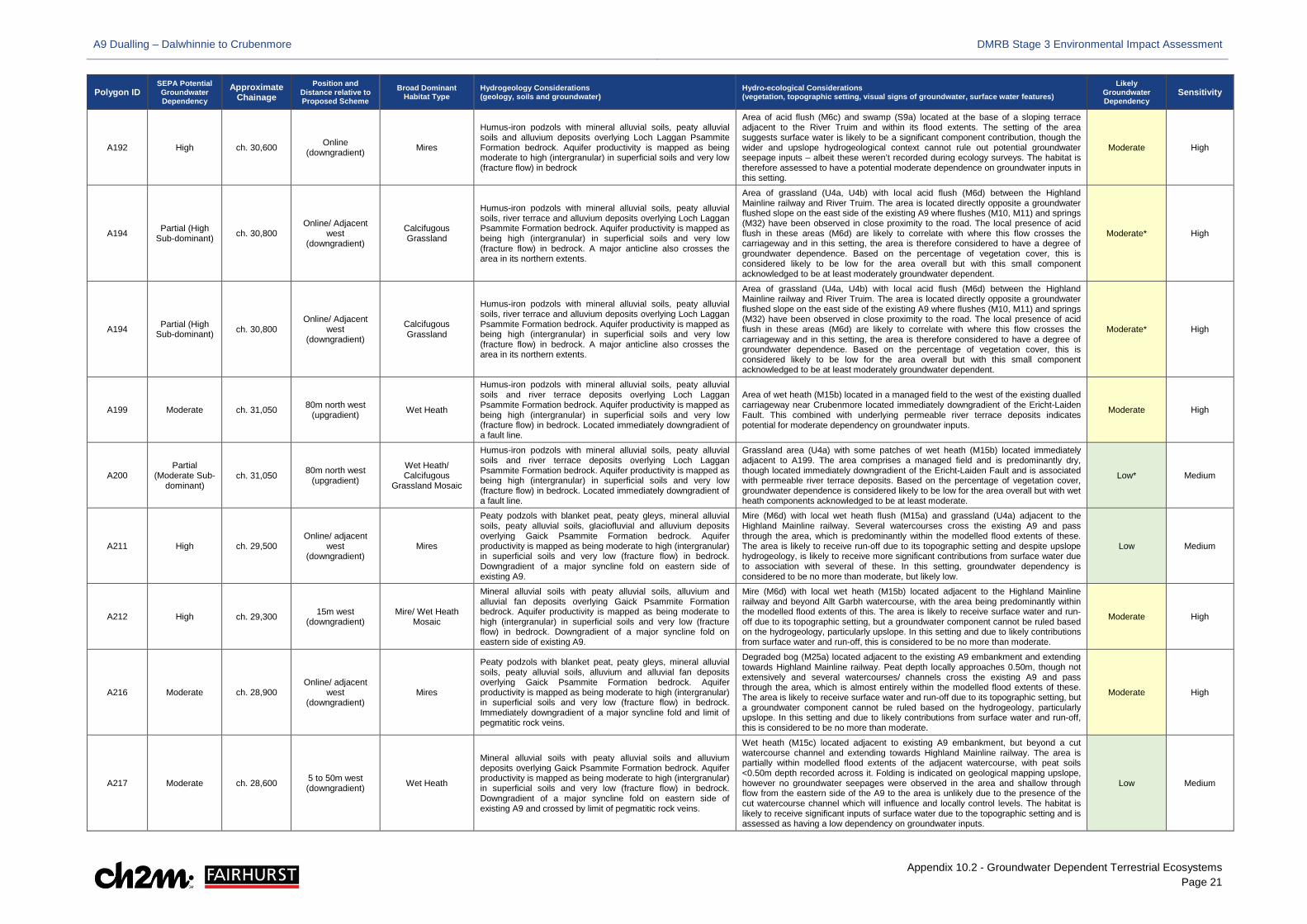
A9 Dualling – Dalwhinnie to Crubenmore DMRB Stage 3 Environmental Impact Assessment
Appendix 10.2 - Groundwater Dependent Terrestrial Ecosystems Page 21
Polygon ID SEPA Potential Groundwater Dependency
Approximate Chainage
Position and Distance relative to Proposed Scheme
Broad Dominant Habitat Type
Hydrogeology Considerations (geology, soils and groundwater)
Hydro-ecological Considerations (vegetation, topographic setting, visual signs of groundwater, surface water features)
Likely Groundwater Dependency
Sensitivity
A192 High ch. 30,600 Online (downgradient) Mires
Humus-iron podzols with mineral alluvial soils, peaty alluvial soils and alluvium deposits overlying Loch Laggan Psammite Formation bedrock. Aquifer productivity is mapped as being moderate to high (intergranular) in superficial soils and very low (fracture flow) in bedrock
Area of acid flush (M6c) and swamp (S9a) located at the base of a sloping terrace adjacent to the River Truim and within its flood extents. The setting of the area suggests surface water is likely to be a significant component contribution, though the wider and upslope hydrogeological context cannot rule out potential groundwater seepage inputs – albeit these weren’t recorded during ecology surveys. The habitat is therefore assessed to have a potential moderate dependence on groundwater inputs in this setting.
Moderate High
A194 Partial (High Sub-dominant) ch. 30,800
Online/ Adjacent west
(downgradient)
Calcifugous Grassland
Humus-iron podzols with mineral alluvial soils, peaty alluvial soils, river terrace and alluvium deposits overlying Loch Laggan Psammite Formation bedrock. Aquifer productivity is mapped as being high (intergranular) in superficial soils and very low (fracture flow) in bedrock. A major anticline also crosses the area in its northern extents.
Area of grassland (U4a, U4b) with local acid flush (M6d) between the Highland Mainline railway and River Truim. The area is located directly opposite a groundwater flushed slope on the east side of the existing A9 where flushes (M10, M11) and springs (M32) have been observed in close proximity to the road. The local presence of acid flush in these areas (M6d) are likely to correlate with where this flow crosses the carriageway and in this setting, the area is therefore considered to have a degree of groundwater dependence. Based on the percentage of vegetation cover, this is considered likely to be low for the area overall but with this small component acknowledged to be at least moderately groundwater dependent.
Moderate* High
A199 Moderate ch. 31,050 80m north west (upgradient) Wet Heath
Humus-iron podzols with mineral alluvial soils, peaty alluvial soils and river terrace deposits overlying Loch Laggan Psammite Formation bedrock. Aquifer productivity is mapped as being high (intergranular) in superficial soils and very low (fracture flow) in bedrock. Located immediately downgradient of a fault line.
Area of wet heath (M15b) located in a managed field to the west of the existing dualled carriageway near Crubenmore located immediately downgradient of the Ericht-Laiden Fault. This combined with underlying permeable river terrace deposits indicates potential for moderate dependency on groundwater inputs.
Moderate High
A200 Partial
(Moderate Sub-dominant)
ch. 31,050 80m north west (upgradient)
Wet Heath/ Calcifugous
Grassland Mosaic
Humus-iron podzols with mineral alluvial soils, peaty alluvial soils and river terrace deposits overlying Loch Laggan Psammite Formation bedrock. Aquifer productivity is mapped as being high (intergranular) in superficial soils and very low (fracture flow) in bedrock. Located immediately downgradient of a fault line.
Grassland area (U4a) with some patches of wet heath (M15b) located immediately adjacent to A199. The area comprises a managed field and is predominantly dry, though located immediately downgradient of the Ericht-Laiden Fault and is associated with permeable river terrace deposits. Based on the percentage of vegetation cover, groundwater dependence is considered likely to be low for the area overall but with wet heath components acknowledged to be at least moderate.
Low* Medium
A211 High ch. 29,500 Online/ adjacent
west (downgradient)
Mires
Peaty podzols with blanket peat, peaty gleys, mineral alluvial soils, peaty alluvial soils, glaciofluvial and alluvium deposits overlying Gaick Psammite Formation bedrock. Aquifer productivity is mapped as being moderate to high (intergranular) in superficial soils and very low (fracture flow) in bedrock. Downgradient of a major syncline fold on eastern side of existing A9.
Mire (M6d) with local wet heath flush (M15a) and grassland (U4a) adjacent to the Highland Mainline railway. Several watercourses cross the existing A9 and pass through the area, which is predominantly within the modelled flood extents of these. The area is likely to receive run-off due to its topographic setting and despite upslope hydrogeology, is likely to receive more significant contributions from surface water due to association with several of these. In this setting, groundwater dependency is considered to be no more than moderate, but likely low.
Low Medium
A212 High ch. 29,300 15m west (downgradient)
Mire/ Wet Heath Mosaic
Mineral alluvial soils with peaty alluvial soils, alluvium and alluvial fan deposits overlying Gaick Psammite Formation bedrock. Aquifer productivity is mapped as being moderate to high (intergranular) in superficial soils and very low (fracture flow) in bedrock. Downgradient of a major syncline fold on eastern side of existing A9.
Mire (M6d) with local wet heath (M15b) located adjacent to the Highland Mainline railway and beyond Allt Garbh watercourse, with the area being predominantly within the modelled flood extents of this. The area is likely to receive surface water and run-off due to its topographic setting, but a groundwater component cannot be ruled based on the hydrogeology, particularly upslope. In this setting and due to likely contributions from surface water and run-off, this is considered to be no more than moderate.
Moderate High
A216 Moderate ch. 28,900 Online/ adjacent
west (downgradient)
Mires
Peaty podzols with blanket peat, peaty gleys, mineral alluvial soils, peaty alluvial soils, alluvium and alluvial fan deposits overlying Gaick Psammite Formation bedrock. Aquifer productivity is mapped as being moderate to high (intergranular) in superficial soils and very low (fracture flow) in bedrock. Immediately downgradient of a major syncline fold and limit of pegmatitic rock veins.
Degraded bog (M25a) located adjacent to the existing A9 embankment and extending towards Highland Mainline railway. Peat depth locally approaches 0.50m, though not extensively and several watercourses/ channels cross the existing A9 and pass through the area, which is almost entirely within the modelled flood extents of these. The area is likely to receive surface water and run-off due to its topographic setting, but a groundwater component cannot be ruled based on the hydrogeology, particularly upslope. In this setting and due to likely contributions from surface water and run-off, this is considered to be no more than moderate.
Moderate High
A217 Moderate ch. 28,600 5 to 50m west (downgradient) Wet Heath
Mineral alluvial soils with peaty alluvial soils and alluvium deposits overlying Gaick Psammite Formation bedrock. Aquifer productivity is mapped as being moderate to high (intergranular) in superficial soils and very low (fracture flow) in bedrock. Downgradient of a major syncline fold on eastern side of existing A9 and crossed by limit of pegmatitic rock veins.
Wet heath (M15c) located adjacent to existing A9 embankment, but beyond a cut watercourse channel and extending towards Highland Mainline railway. The area is partially within modelled flood extents of the adjacent watercourse, with peat soils <0.50m depth recorded across it. Folding is indicated on geological mapping upslope, however no groundwater seepages were observed in the area and shallow through flow from the eastern side of the A9 to the area is unlikely due to the presence of the cut watercourse channel which will influence and locally control levels. The habitat is likely to receive significant inputs of surface water due to the topographic setting and is assessed as having a low dependency on groundwater inputs.
Low Medium

A9 Dualling – Dalwhinnie to Crubenmore DMRB Stage 3 Environmental Impact Assessment
Appendix 10.2 - Groundwater Dependent Terrestrial Ecosystems Page 22
Polygon ID SEPA Potential Groundwater Dependency
Approximate Chainage
Position and Distance relative to Proposed Scheme
Broad Dominant Habitat Type
Hydrogeology Considerations (geology, soils and groundwater)
Hydro-ecological Considerations (vegetation, topographic setting, visual signs of groundwater, surface water features)
Likely Groundwater Dependency
Sensitivity
A224 Partial
(Moderate Sub-dominant)
ch. 28,500 Online/ adjacent
west (downgradient)
Mire/ Calcifugous Grassland Mosaic
Mineral alluvial soils with peaty alluvial soils and alluvium deposits overlying Gaick Psammite Formation bedrock. Aquifer productivity is mapped as being moderate to high (intergranular) in superficial soils and very low (fracture flow) in bedrock. Downgradient of a major syncline fold.
Grassland (U5a) and local mire (M25a) immediately adjacent to existing A9 embankment, bisected by a watercourse channel which crosses the existing A9. The topographic setting indicates the area is likely to receive a significant contribution of run-off from the adjacent embankment, but groundwater component cannot be ruled based on the upslope hydrogeology, where several distinct M10 flushes are present on the eastern side of the existing A9. In this setting however, potential dependence is considered to be no more than low.
Low* Medium
A226 High ch. 28,000 Online/ adjacent
west (downgradient)
Wet Heath
Mineral alluvial soils with peaty alluvial soils, glaciofluvial and alluvium deposits overlying Gaick Psammite Formation bedrock. Aquifer productivity is mapped as being moderate to high (intergranular) in superficial soils and very low (fracture flow) in bedrock. Downgradient of a major syncline fold.
Wet heath (M16d, M15b) and mire (M6a, M25a) adjacent to existing A9 embankment and extending towards Highland Mainline railway, within the flood extents of several watercourses which enter and pass through the area. The topographic setting indicates the area is likely to receive contributions of surface water and run-off, but a groundwater component is possible based on the underlying and upslope hydrogeology, where several distinct M10 flushes are present on the eastern side of the existing A9. In this setting, potential dependence is considered to be no more than moderate.
Moderate High
A235 Moderate ch. 31,050 60m north east (upgradient) Wet Heath
Humus-iron podzols with peaty podzols, mineral alluvial soils and peaty alluvial soils overlying Loch Laggan Psammite Formation bedrock. Aquifer productivity mapping identifies this as very low (fracture flow) in bedrock. Downgradient of major anticline fold.
Wet heath (M15b), flush (M11b) and spring (M32a) located east of the existing dual carriageway at Crubenmore on sloping ground, where superficial soils are mapped as absent and bedrock is at or close to the surface. The presence of folding upslope and distinct groundwater supplies indicate the habitat is GWDTE with moderate to high dependency on groundwater in this setting.
Moderate/ High High/ Very High
A236 Moderate ch. 31,050 Adjacent east (upgradient)
Wet/ Dry Heath Mosaic
Humus-iron podzols with peaty podzols, mineral alluvial soils and peaty alluvial soils overlying Loch Laggan Psammite Formation bedrock. Aquifer productivity mapping identifies this as very low (fracture flow) in bedrock. Downgradient of major anticline fold.
Wet heath (M15b) and dry heath (H12a) located east of the existing dual carriageway at Crubenmore on sloping ground, where superficial soils are mapped as absent and bedrock is at or close to the surface. The habitat is likely to receive overland flow and run-off due to the topographic setting, but the presence of folding upslope and distinct groundwater supplies in the surrounding area indicate that there is also potential for a groundwater component to supply the area. Based on the vegetation, dependency in this setting is considered to be moderate.
Moderate High
A237 Moderate ch. 31,000 Adjacent east (upgradient) Wet Heath
Humus-iron podzols with peaty podzols, mineral alluvial soils and peaty alluvial soils overlying Loch Laggan Psammite Formation bedrock. Aquifer productivity mapping identifies this as very low (fracture flow) in bedrock. Crossed by a major anticline fold.
Wet heath (M15b) and mire (M19a) located east of the existing dual carriageway at Crubenmore on sloping ground, where superficial soils are mapped as absent and bedrock is at or close to the surface. The habitat is likely to receive overland flow and run-off due to the topographic setting, but the presence of folding upslope and distinct groundwater supplies in the surrounding area indicate that there is also potential for a groundwater component to supply the area. Based on the vegetation, dependency in this setting is considered to be moderate.
Moderate High
A239 Moderate ch. 30,750 Adjacent east (upgradient)
Mire/ Wet Heath Mosaic
Humus-iron podzols with peaty podzols, mineral alluvial soils, peaty alluvial soils, ardverikie till and hummocky glacial deposits overlying Falls of Phones Semipelite Formation bedrock. Aquifer productivity mapping identifies this high (intergranular) in superficial soils and very low (fracture flow) in bedrock. Downgradient of a major anticline fold.
Area of wet heath (M15b), with local mire (M6c) and flush (M10a) at the upslope extents of the area on sloping ground. The presence of folding upslope and distinct groundwater supplies indicate the habitat is GWDTE with moderate to high dependency on groundwater in this setting.
Moderate/ High High/ Very High
A240 Moderate ch. 30,750 80m east (upgradient) Wet Heath
Humus-iron podzols with peaty podzols, mineral alluvial soils, peaty alluvial soils, ardverikie till and hummocky glacial deposits overlying Falls of Phones Semipelite Formation bedrock. Aquifer productivity mapping identifies this high (intergranular) in superficial soils and very low (fracture flow) in bedrock. Downgradient of a major anticline fold.
Area of wet heath (M15b), mire (M6c), flush (M10a) and dry heath (H12a) located to the immediate north of A239 in a distinctly similar setting. As such, the habitat is considered to be GWDTE with moderate to high dependency on groundwater.
Moderate/ High High/ Very High
A242 Moderate ch. 30,650 60m east (upgradient) Wet Heath
Humus-iron podzols with peaty podzols, ardverikie till and hummocky glacial deposits overlying Gaick Psammite Formation bedrock. Aquifer productivity mapping identifies this as very low (fracture flow) in bedrock and not a significant aquifer in superficial soils.
Wet heath (M15b) and mire (M6a) located within an incision adjacent to a watercourse channel on sloping ground. There are frequent springs and flushes cross and upgradient in this area which channelise in flow towards the existing A9 but also watercourses such as this. The habitat is assessed as having a moderate dependency on groundwater inputs based on these observations.
Moderate High
A246 Moderate ch. 30,600 Adjacent east (upgradient) Wet Heath
Humus-iron podzols with peaty podzols and hummocky glacial deposits overlying Gaick Psammite Formation bedrock. Aquifer productivity mapping identifies this as very low (fracture flow) in bedrock and high (intergranular) in superficial soils.
Wet heath (M15b) and dry heath (H12a) located w on sloping ground adjacent to the east of the existing A9 at the top of a cut slope. There are frequent springs and flushes cross and upgradient in this area which channelise in flow towards the existing A9. The habitat will receive overland flow and surface run-off due to the topographic setting, but is assessed as having a moderate dependency on groundwater inputs based on these observations.
Moderate High
A248 Moderate ch. 30,650 60m east (upgradient)
Mire/ Wet Heath Mosaic
Humus-iron podzols with peaty podzols, ardverikie till and hummocky glacial deposits overlying Gaick Psammite Formation bedrock. Aquifer productivity mapping identifies this as very low (fracture flow) in bedrock and not a significant aquifer in superficial soils.
Wet heath (M15b) and dry heath (H12a) located within an incision adjacent to a watercourse channel on sloping ground. There are frequent springs and flushes cross and upgradient in this area which channelise in flow towards the existing A9 but also watercourses such as this. The habitat is assessed as having a moderate dependency on groundwater inputs based on these observations.
Moderate High
A259 Moderate ch. 30,500 Online/ adjacent east (upgradient)
Wet/ Dry Heath Mosaic
Humus-iron podzols with peaty podzols, mineral alluvial soils, peaty alluvial soils, ardverikie till and hummocky (moundy) glacial deposits overlying Gaick Psammite Formation bedrock. Aquifer productivity mapping identifies this as high (intergranular) in superficial soils and very low (fracture flow) in bedrock.
Area of wet heath (M15b) and dry heath (H12a), with spring community (M32a) located at the upslope extent on sloping ground. The distinct groundwater supplying the area and surrounding hydrogeological context indicate the habitat is GWDTE with moderate to high dependency on groundwater in this setting.
Moderate/ High High/ Very High
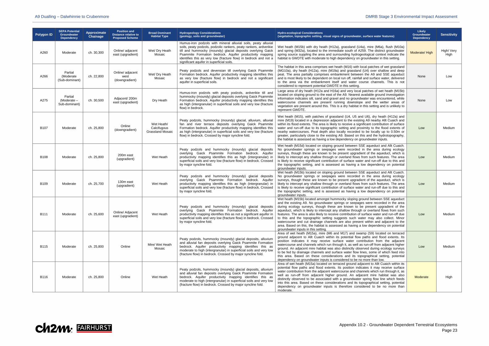
A9 Dualling – Dalwhinnie to Crubenmore DMRB Stage 3 Environmental Impact Assessment
Appendix 10.2 - Groundwater Dependent Terrestrial Ecosystems Page 23
Polygon ID SEPA Potential Groundwater Dependency
Approximate Chainage
Position and Distance relative to Proposed Scheme
Broad Dominant Habitat Type
Hydrogeology Considerations (geology, soils and groundwater)
Hydro-ecological Considerations (vegetation, topographic setting, visual signs of groundwater, surface water features)
Likely Groundwater Dependency
Sensitivity
A260 Moderate ch. 30,300 Online/ adjacent east (upgradient)
Wet/ Dry Heath Mosaic
Humus-iron podzols with mineral alluvial soils, peaty alluvial soils, peaty podzols, podzolic rankers, peaty rankers, ardverikie till and hummocky (moundy) glacial deposits overlying Gaick Psammite Formation bedrock. Aquifer productivity mapping identifies this as very low (fracture flow) in bedrock and not a significant aquifer in superficial soils.
Wet heath (M15b) with dry heath (H12a), grassland (U4a), mire (M6a), flush (M10a) and spring (M32a), located to the immediate south of A259. The distinct groundwater spring source suppling the area and surrounding hydrogeological context indicate the habitat is GWDTE with moderate to high dependency on groundwater in this setting.
Moderate/ High High/ Very High
A266 Partial
(Moderate (Sub-dominant)
ch. 22,800 Online/ adjacent
west (downgradient)
Wet/ Dry Heath Mosaic
Peaty podzols and devensian till overlying Gaick Psammite Formation bedrock. Aquifer productivity mapping identifies this as very low (fracture flow) in bedrock and not a significant aquifer in superficial soils.
The habitat in this area comprises wet heath (M16) with local patches of wet grassland (MG10a), dry heath (H12a), mire (M19a) and grassland (U4) over shallow and deep peat. The area partially comprises embankment between the A9 and SSE aqueduct and is most likely to be dependent on local run off, rainfall and surface water, delivered to the area via the embankment itself and water course channels. This is not considered to represent potential GWDTE in this setting.
None Low
A275 Partial
(Moderate – Sub-dominant)
ch. 30,500 Adjacent/ 200m east (upgradient) Dry Heath
Humus-iron podzols with peaty podzols, ardverikie till and hummocky (moundy) glacial deposits overlying Gaick Psammite Formation bedrock. Aquifer productivity mapping identifies this as high (intergranular) in superficial soils and very low (fracture flow) in bedrock.
Large area of dry heath (H12a and H16a) and very local patches of wet heath (M15b) located on sloping ground to the east of the A9. Nearest available ground investigation information indicates silt, sand and gravel and no groundwater was encountered, while watercourse channels are present running downslope and the wetter areas of vegetation are present around this. This is a dry habitat in this setting and is unlikely to represent GWDTE.
None Low
B107 Moderate ch. 25,800 Online (downgradient)
Wet Heath/ Calcifugous
Grassland Mosaic
Peaty podzols, hummocky (moundy) glacial, alluvium, alluvial fan and river terrace deposits overlying Gaick Psammite Formation bedrock. Aquifer productivity mapping identifies this as high (intergranular) in superficial soils and very low (fracture flow) in bedrock. Crossed by major syncline fold.
Wet heath (M15), with patches of grassland (U4, U5 and U6), dry heath (H12a) and mire (M19) located in a depression adjacent to the existing A9 nearby Allt Cuaich and within its flood extents. The area is likely to receive a significant contribution of surface water and run-off due to its topographic setting and proximity to the flood extents of nearby watercourses. Peat depth also locally recorded to be locally up to 0.50m or greater, particularly close to the existing A9. Based on this and the hydrotopography, the habitat is assessed as having a low dependency on groundwater inputs.
Low Medium
B108 Moderate ch. 25,800 200m east (upgradient) Wet Heath
Peaty podzols and hummocky (moundy) glacial deposits overlying Gaick Psammite Formation bedrock. Aquifer productivity mapping identifies this as high (intergranular) in superficial soils and very low (fracture flow) in bedrock. Crossed by major syncline fold.
Wet heath (M15d) located on sloping ground between SSE aqueduct and Allt Cuaich. No groundwater springs or seepages were recorded in the area during ecology surveys, though these are known to be present upgradient of the aqueduct, which is likely to intercept any shallow through or overland flows from such features. The area is likely to receive significant contribution of surface water and run-off due to this and the topographic setting, and is assessed as having a low dependency on potential groundwater inputs.
Low Medium
B109 Moderate ch. 25,700 130m east (upgradient) Wet Heath
Peaty podzols and hummocky (moundy) glacial deposits overlying Gaick Psammite Formation bedrock. Aquifer productivity mapping identifies this as high (intergranular) in superficial soils and very low (fracture flow) in bedrock. Crossed by major syncline fold.
Wet heath (M15b) located on sloping ground between SSE aqueduct and Allt Cuaich. No groundwater springs or seepages were recorded in the area during ecology surveys, though these are known to be present upgradient of the aqueduct, which is likely to intercept any shallow through or overland flows from such features. The area is likely to receive significant contribution of surface water and run-off due to this and the topographic setting, and is assessed as having a low dependency on potential groundwater inputs.
Low Medium
B111 Moderate ch. 25,600 Online/ Adjacent east (upgradient) Wet Heath
Peaty podzols and hummocky (moundy) glacial deposits overlying Gaick Psammite Formation bedrock. Aquifer productivity mapping identifies this as not a significant aquifer in superficial soils and very low (fracture flow) in bedrock. Crossed by major syncline fold.
Wet heath (M15b) located amongst hummocky sloping ground between SSE aqueduct and the existing A9. No groundwater springs or seepages were recorded in the area during ecology surveys, though these are known to be present upgradient of the aqueduct, which is likely to intercept any shallow through or overland flows from such features. The area is also likely to receive contribution of surface water and run-off due to this and the topographic setting suggests such water may also collect. Minor watercourse and cut drainage channels are also present within and adjacent to the area. Based on this, the habitat is assessed as having a low dependency on potential groundwater inputs in this setting.
Low Medium
B115 Moderate ch. 25,800 Online Mire/ Wet Heath Mosaic
Peaty podzols, hummocky (moundy) glacial deposits, alluvium and alluvial fan deposits overlying Gaick Psammite Formation bedrock. Aquifer productivity mapping identifies this as moderate to high (intergranular) in superficial soils and very low (fracture flow) in bedrock. Crossed by major syncline fold.
Area of wet heath (M15a), mire (M6 and M17) and swamp (S9) located on terraced ground adjacent to Allt Cuaich within its potential flow paths and flood extents. Its position indicates it may receive surface water contribution from the adjacent watercourse and channels which run through it, as well as run-off from adjacent higher ground. An adjacent mire habitat was also distinctly observed during ecology surveys to be fed by drainage channels and surface water flow lines, some of which feed into this area. Based on these considerations and its topographical setting, potential dependency on groundwater inputs is considered to be no more than low.
Low Medium
B116 Moderate ch. 25,800 Online Wet Heath
Peaty podzols, hummocky (moundy) glacial deposits, alluvium and alluvial fan deposits overlying Gaick Psammite Formation bedrock. Aquifer productivity mapping identifies this as moderate to high (intergranular) in superficial soils and very low (fracture flow) in bedrock. Crossed by major syncline fold.
Area of wet heath (M15a) located on terraced ground adjacent to Allt Cuaich within its potential flow paths and flood extents. Its position indicates it may receive surface water contribution from the adjacent watercourse and channels which run through it, as well as run-off from adjacent higher ground. An adjacent mire habitat was also distinctly observed to be associated with a groundwater spring flow line which feeds into this area. Based on these considerations and its topographical setting, potential dependency on groundwater inputs is therefore considered to be no more than moderate.
Moderate High
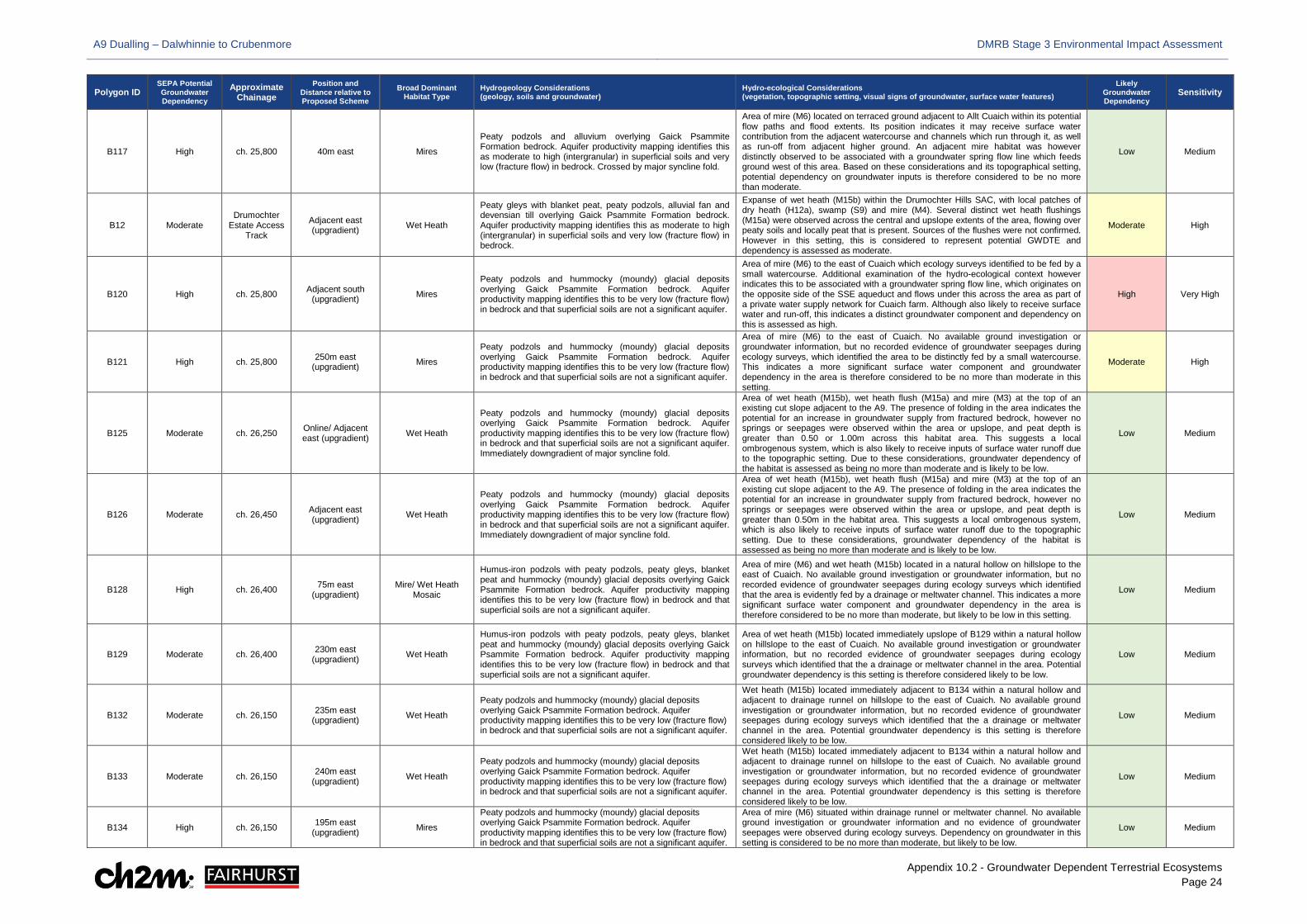
A9 Dualling – Dalwhinnie to Crubenmore DMRB Stage 3 Environmental Impact Assessment
Appendix 10.2 - Groundwater Dependent Terrestrial Ecosystems Page 24
Polygon ID SEPA Potential Groundwater Dependency
Approximate Chainage
Position and Distance relative to Proposed Scheme
Broad Dominant Habitat Type
Hydrogeology Considerations (geology, soils and groundwater)
Hydro-ecological Considerations (vegetation, topographic setting, visual signs of groundwater, surface water features)
Likely Groundwater Dependency
Sensitivity
B117 High ch. 25,800 40m east Mires
Peaty podzols and alluvium overlying Gaick Psammite Formation bedrock. Aquifer productivity mapping identifies this as moderate to high (intergranular) in superficial soils and very low (fracture flow) in bedrock. Crossed by major syncline fold.
Area of mire (M6) located on terraced ground adjacent to Allt Cuaich within its potential flow paths and flood extents. Its position indicates it may receive surface water contribution from the adjacent watercourse and channels which run through it, as well as run-off from adjacent higher ground. An adjacent mire habitat was however distinctly observed to be associated with a groundwater spring flow line which feeds ground west of this area. Based on these considerations and its topographical setting, potential dependency on groundwater inputs is therefore considered to be no more than moderate.
Low Medium
B12 Moderate Drumochter
Estate Access Track
Adjacent east (upgradient) Wet Heath
Peaty gleys with blanket peat, peaty podzols, alluvial fan and devensian till overlying Gaick Psammite Formation bedrock. Aquifer productivity mapping identifies this as moderate to high (intergranular) in superficial soils and very low (fracture flow) in bedrock.
Expanse of wet heath (M15b) within the Drumochter Hills SAC, with local patches of dry heath (H12a), swamp (S9) and mire (M4). Several distinct wet heath flushings (M15a) were observed across the central and upslope extents of the area, flowing over peaty soils and locally peat that is present. Sources of the flushes were not confirmed. However in this setting, this is considered to represent potential GWDTE and dependency is assessed as moderate.
Moderate High
B120 High ch. 25,800 Adjacent south (upgradient) Mires
Peaty podzols and hummocky (moundy) glacial deposits overlying Gaick Psammite Formation bedrock. Aquifer productivity mapping identifies this to be very low (fracture flow) in bedrock and that superficial soils are not a significant aquifer.
Area of mire (M6) to the east of Cuaich which ecology surveys identified to be fed by a small watercourse. Additional examination of the hydro-ecological context however indicates this to be associated with a groundwater spring flow line, which originates on the opposite side of the SSE aqueduct and flows under this across the area as part of a private water supply network for Cuaich farm. Although also likely to receive surface water and run-off, this indicates a distinct groundwater component and dependency on this is assessed as high.
High Very High
B121 High ch. 25,800 250m east (upgradient) Mires
Peaty podzols and hummocky (moundy) glacial deposits overlying Gaick Psammite Formation bedrock. Aquifer productivity mapping identifies this to be very low (fracture flow) in bedrock and that superficial soils are not a significant aquifer.
Area of mire (M6) to the east of Cuaich. No available ground investigation or groundwater information, but no recorded evidence of groundwater seepages during ecology surveys, which identified the area to be distinctly fed by a small watercourse. This indicates a more significant surface water component and groundwater dependency in the area is therefore considered to be no more than moderate in this setting.
Moderate High
B125 Moderate ch. 26,250 Online/ Adjacent east (upgradient) Wet Heath
Peaty podzols and hummocky (moundy) glacial deposits overlying Gaick Psammite Formation bedrock. Aquifer productivity mapping identifies this to be very low (fracture flow) in bedrock and that superficial soils are not a significant aquifer. Immediately downgradient of major syncline fold.
Area of wet heath (M15b), wet heath flush (M15a) and mire (M3) at the top of an existing cut slope adjacent to the A9. The presence of folding in the area indicates the potential for an increase in groundwater supply from fractured bedrock, however no springs or seepages were observed within the area or upslope, and peat depth is greater than 0.50 or 1.00m across this habitat area. This suggests a local ombrogenous system, which is also likely to receive inputs of surface water runoff due to the topographic setting. Due to these considerations, groundwater dependency of the habitat is assessed as being no more than moderate and is likely to be low.
Low Medium
B126 Moderate ch. 26,450 Adjacent east (upgradient) Wet Heath
Peaty podzols and hummocky (moundy) glacial deposits overlying Gaick Psammite Formation bedrock. Aquifer productivity mapping identifies this to be very low (fracture flow) in bedrock and that superficial soils are not a significant aquifer. Immediately downgradient of major syncline fold.
Area of wet heath (M15b), wet heath flush (M15a) and mire (M3) at the top of an existing cut slope adjacent to the A9. The presence of folding in the area indicates the potential for an increase in groundwater supply from fractured bedrock, however no springs or seepages were observed within the area or upslope, and peat depth is greater than 0.50m in the habitat area. This suggests a local ombrogenous system, which is also likely to receive inputs of surface water runoff due to the topographic setting. Due to these considerations, groundwater dependency of the habitat is assessed as being no more than moderate and is likely to be low.
Low Medium
B128 High ch. 26,400 75m east (upgradient)
Mire/ Wet Heath Mosaic
Humus-iron podzols with peaty podzols, peaty gleys, blanket peat and hummocky (moundy) glacial deposits overlying Gaick Psammite Formation bedrock. Aquifer productivity mapping identifies this to be very low (fracture flow) in bedrock and that superficial soils are not a significant aquifer.
Area of mire (M6) and wet heath (M15b) located in a natural hollow on hillslope to the east of Cuaich. No available ground investigation or groundwater information, but no recorded evidence of groundwater seepages during ecology surveys which identified that the area is evidently fed by a drainage or meltwater channel. This indicates a more significant surface water component and groundwater dependency in the area is therefore considered to be no more than moderate, but likely to be low in this setting.
Low Medium
B129 Moderate ch. 26,400 230m east (upgradient) Wet Heath
Humus-iron podzols with peaty podzols, peaty gleys, blanket peat and hummocky (moundy) glacial deposits overlying Gaick Psammite Formation bedrock. Aquifer productivity mapping identifies this to be very low (fracture flow) in bedrock and that superficial soils are not a significant aquifer.
Area of wet heath (M15b) located immediately upslope of B129 within a natural hollow on hillslope to the east of Cuaich. No available ground investigation or groundwater information, but no recorded evidence of groundwater seepages during ecology surveys which identified that the a drainage or meltwater channel in the area. Potential groundwater dependency is this setting is therefore considered likely to be low.
Low Medium
B132 Moderate ch. 26,150 235m east (upgradient) Wet Heath
Peaty podzols and hummocky (moundy) glacial deposits overlying Gaick Psammite Formation bedrock. Aquifer productivity mapping identifies this to be very low (fracture flow) in bedrock and that superficial soils are not a significant aquifer.
Wet heath (M15b) located immediately adjacent to B134 within a natural hollow and adjacent to drainage runnel on hillslope to the east of Cuaich. No available ground investigation or groundwater information, but no recorded evidence of groundwater seepages during ecology surveys which identified that the a drainage or meltwater channel in the area. Potential groundwater dependency is this setting is therefore considered likely to be low.
Low Medium
B133 Moderate ch. 26,150 240m east (upgradient) Wet Heath
Peaty podzols and hummocky (moundy) glacial deposits overlying Gaick Psammite Formation bedrock. Aquifer productivity mapping identifies this to be very low (fracture flow) in bedrock and that superficial soils are not a significant aquifer.
Wet heath (M15b) located immediately adjacent to B134 within a natural hollow and adjacent to drainage runnel on hillslope to the east of Cuaich. No available ground investigation or groundwater information, but no recorded evidence of groundwater seepages during ecology surveys which identified that the a drainage or meltwater channel in the area. Potential groundwater dependency is this setting is therefore considered likely to be low.
Low Medium
B134 High ch. 26,150 195m east (upgradient) Mires
Peaty podzols and hummocky (moundy) glacial deposits overlying Gaick Psammite Formation bedrock. Aquifer productivity mapping identifies this to be very low (fracture flow) in bedrock and that superficial soils are not a significant aquifer.
Area of mire (M6) situated within drainage runnel or meltwater channel. No available ground investigation or groundwater information and no evidence of groundwater seepages were observed during ecology surveys. Dependency on groundwater in this setting is considered to be no more than moderate, but likely to be low.
Low Medium
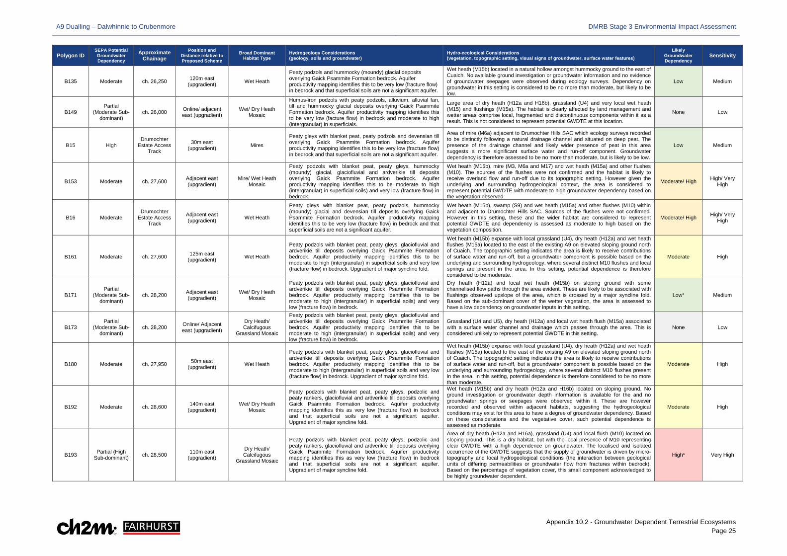
A9 Dualling – Dalwhinnie to Crubenmore DMRB Stage 3 Environmental Impact Assessment
Appendix 10.2 - Groundwater Dependent Terrestrial Ecosystems Page 25
Polygon ID SEPA Potential Groundwater Dependency
Approximate Chainage
Position and Distance relative to Proposed Scheme
Broad Dominant Habitat Type
Hydrogeology Considerations (geology, soils and groundwater)
Hydro-ecological Considerations (vegetation, topographic setting, visual signs of groundwater, surface water features)
Likely Groundwater Dependency
Sensitivity
B135 Moderate ch. 26,250 120m east (upgradient) Wet Heath
Peaty podzols and hummocky (moundy) glacial deposits overlying Gaick Psammite Formation bedrock. Aquifer productivity mapping identifies this to be very low (fracture flow) in bedrock and that superficial soils are not a significant aquifer.
Wet heath (M15b) located in a natural hollow amongst hummocky ground to the east of Cuaich. No available ground investigation or groundwater information and no evidence of groundwater seepages were observed during ecology surveys. Dependency on groundwater in this setting is considered to be no more than moderate, but likely to be low.
Low Medium
B149 Partial
(Moderate Sub-dominant)
ch. 26,000 Online/ adjacent east (upgradient)
Wet/ Dry Heath Mosaic
Humus-iron podzols with peaty podzols, alluvium, alluvial fan, till and hummocky glacial deposits overlying Gaick Psammite Formation bedrock. Aquifer productivity mapping identifies this to be very low (facture flow) in bedrock and moderate to high (intergranular) in superficials.
Large area of dry heath (H12a and H16b), grassland (U4) and very local wet heath (M15) and flushings (M15a). The habitat is clearly affected by land management and wetter areas comprise local, fragmented and discontinuous components within it as a result. This is not considered to represent potential GWDTE at this location.
None Low
B15 High Drumochter
Estate Access Track
30m east (upgradient) Mires
Peaty gleys with blanket peat, peaty podzols and devensian till overlying Gaick Psammite Formation bedrock. Aquifer productivity mapping identifies this to be very low (fracture flow) in bedrock and that superficial soils are not a significant aquifer.
Area of mire (M6a) adjacent to Drumochter Hills SAC which ecology surveys recorded to be distinctly following a natural drainage channel and situated on deep peat. The presence of the drainage channel and likely wider presence of peat in this area suggests a more significant surface water and run-off component. Groundwater dependency is therefore assessed to be no more than moderate, but is likely to be low.
Low Medium
B153 Moderate ch. 27,600 Adjacent east (upgradient)
Mire/ Wet Heath Mosaic
Peaty podzols with blanket peat, peaty gleys, hummocky (moundy) glacial, glaciofluvial and ardverikie till deposits overlying Gaick Psammite Formation bedrock. Aquifer productivity mapping identifies this to be moderate to high (intergranular) in superficial soils) and very low (fracture flow) in bedrock.
Wet heath (M15b), mire (M3, M6a and M17) and wet heath (M15a) and other flushes (M10). The sources of the flushes were not confirmed and the habitat is likely to receive overland flow and run-off due to its topographic setting. However given the underlying and surrounding hydrogeological context, the area is considered to represent potential GWDTE with moderate to high groundwater dependency based on the vegetation observed.
Moderate/ High High/ Very High
B16 Moderate Drumochter
Estate Access Track
Adjacent east (upgradient) Wet Heath
Peaty gleys with blanket peat, peaty podzols, hummocky (moundy) glacial and devensian till deposits overlying Gaick Psammite Formation bedrock. Aquifer productivity mapping identifies this to be very low (fracture flow) in bedrock and that superficial soils are not a significant aquifer.
Wet heath (M15b), swamp (S9) and wet heath (M15a) and other flushes (M10) within and adjacent to Drumochter Hills SAC. Sources of the flushes were not confirmed. However in this setting, these and the wider habitat are considered to represent potential GWDTE and dependency is assessed as moderate to high based on the vegetation composition.
Moderate/ High High/ Very High
B161 Moderate ch. 27,600 125m east (upgradient) Wet Heath
Peaty podzols with blanket peat, peaty gleys, glaciofluvial and ardverikie till deposits overlying Gaick Psammite Formation bedrock. Aquifer productivity mapping identifies this to be moderate to high (intergranular) in superficial soils and very low (fracture flow) in bedrock. Upgradient of major syncline fold.
Wet heath (M15b) expanse with local grassland (U4), dry heath (H12a) and wet heath flushes (M15a) located to the east of the existing A9 on elevated sloping ground north of Cuaich. The topographic setting indicates the area is likely to receive contributions of surface water and run-off, but a groundwater component is possible based on the underlying and surrounding hydrogeology, where several distinct M10 flushes and local springs are present in the area. In this setting, potential dependence is therefore considered to be moderate.
Moderate High
B171 Partial
(Moderate Sub-dominant)
ch. 28,200 Adjacent east (upgradient)
Wet/ Dry Heath Mosaic
Peaty podzols with blanket peat, peaty gleys, glaciofluvial and ardverikie till deposits overlying Gaick Psammite Formation bedrock. Aquifer productivity mapping identifies this to be moderate to high (intergranular) in superficial soils) and very low (fracture flow) in bedrock.
Dry heath (H12a) and local wet heath (M15b) on sloping ground with some channelised flow paths through the area evident. These are likely to be associated with flushings observed upslope of the area, which is crossed by a major syncline fold. Based on the sub-dominant cover of the wetter vegetation, the area is assessed to have a low dependency on groundwater inputs in this setting.
Low* Medium
B173 Partial
(Moderate Sub-dominant)
ch. 28,200 Online/ Adjacent east (upgradient)
Dry Heath/ Calcifugous
Grassland Mosaic
Peaty podzols with blanket peat, peaty gleys, glaciofluvial and ardverikie till deposits overlying Gaick Psammite Formation bedrock. Aquifer productivity mapping identifies this to be moderate to high (intergranular) in superficial soils) and very low (fracture flow) in bedrock.
Grassland (U4 and U5), dry heath (H12a) and local wet heath flush (M15a) associated with a surface water channel and drainage which passes through the area. This is considered unlikely to represent potential GWDTE in this setting.
None Low
B180 Moderate ch. 27,950 50m east (upgradient) Wet Heath
Peaty podzols with blanket peat, peaty gleys, glaciofluvial and ardverikie till deposits overlying Gaick Psammite Formation bedrock. Aquifer productivity mapping identifies this to be moderate to high (intergranular) in superficial soils and very low (fracture flow) in bedrock. Upgradient of major syncline fold.
Wet heath (M15b) expanse with local grassland (U4), dry heath (H12a) and wet heath flushes (M15a) located to the east of the existing A9 on elevated sloping ground north of Cuaich. The topographic setting indicates the area is likely to receive contributions of surface water and run-off, but a groundwater component is possible based on the underlying and surrounding hydrogeology, where several distinct M10 flushes present in the area. In this setting, potential dependence is therefore considered to be no more than moderate.
Moderate High
B192 Moderate ch. 28,600 140m east (upgradient)
Wet/ Dry Heath Mosaic
Peaty podzols with blanket peat, peaty gleys, podzolic and peaty rankers, glaciofluvial and ardverikie till deposits overlying Gaick Psammite Formation bedrock. Aquifer productivity mapping identifies this as very low (fracture flow) in bedrock and that superficial soils are not a significant aquifer. Upgradient of major syncline fold.
Wet heath (M15b) and dry heath (H12a and H16b) located on sloping ground. No ground investigation or groundwater depth information is available for the and no groundwater springs or seepages were observed within it. These are however recorded and observed within adjacent habitats, suggesting the hydrogeological conditions may exist for this area to have a degree of groundwater dependency. Based on these considerations and the vegetative cover, such potential dependence is assessed as moderate.
Moderate High
B193 Partial (High Sub-dominant) ch. 28,500 110m east
(upgradient)
Dry Heath/ Calcifugous
Grassland Mosaic
Peaty podzols with blanket peat, peaty gleys, podzolic and peaty rankers, glaciofluvial and ardverikie till deposits overlying Gaick Psammite Formation bedrock. Aquifer productivity mapping identifies this as very low (fracture flow) in bedrock and that superficial soils are not a significant aquifer. Upgradient of major syncline fold.
Area of dry heath (H12a and H16a), grassland (U4) and local flush (M10) located on sloping ground. This is a dry habitat, but with the local presence of M10 representing clear GWDTE with a high dependence on groundwater. The localised and isolated occurrence of the GWDTE suggests that the supply of groundwater is driven by micro-topography and local hydrogeological conditions (the interaction between geological units of differing permeabilities or groundwater flow from fractures within bedrock). Based on the percentage of vegetation cover, this small component acknowledged to be highly groundwater dependent.
High* Very High
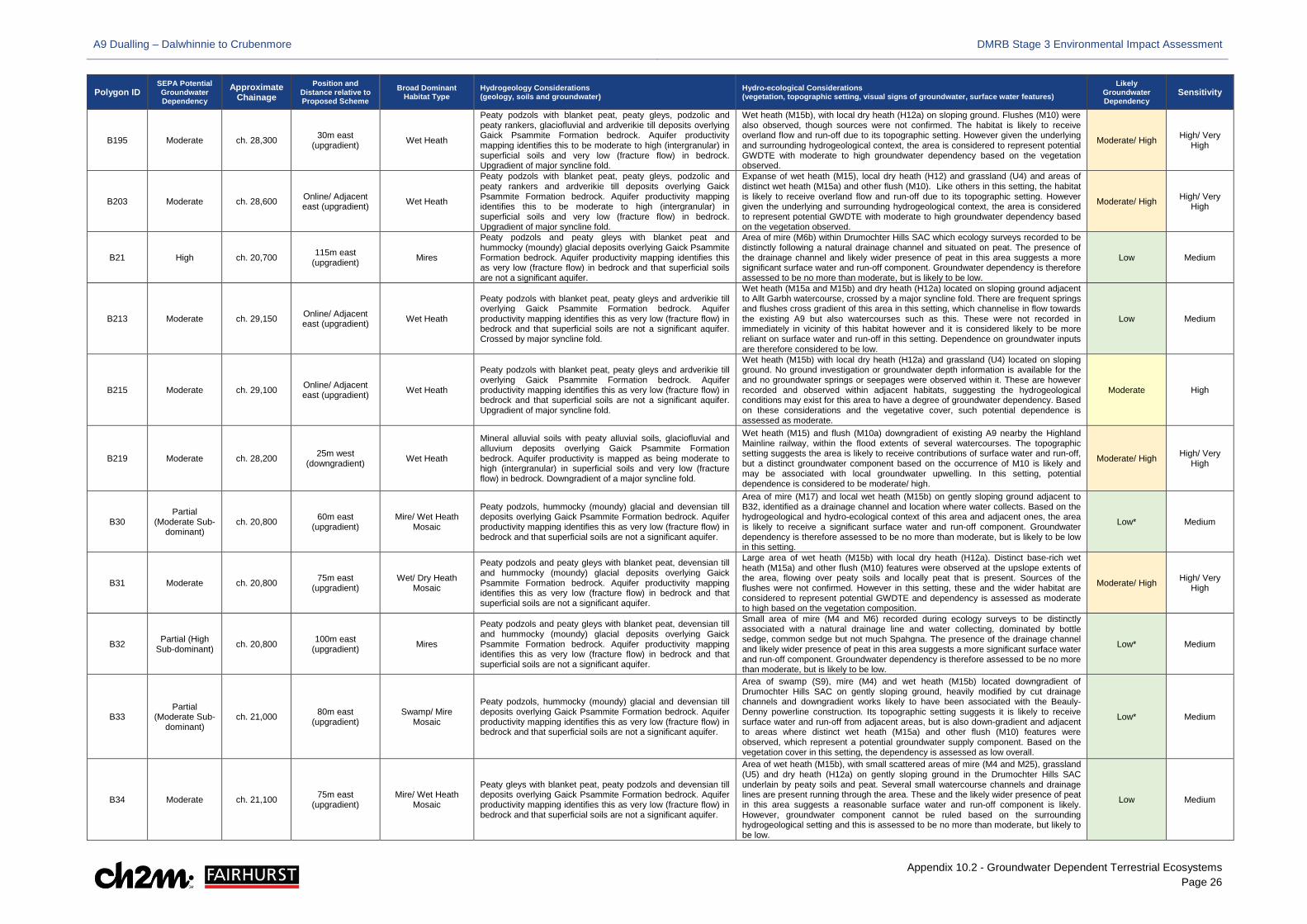
A9 Dualling – Dalwhinnie to Crubenmore DMRB Stage 3 Environmental Impact Assessment
Appendix 10.2 - Groundwater Dependent Terrestrial Ecosystems Page 26
Polygon ID SEPA Potential Groundwater Dependency
Approximate Chainage
Position and Distance relative to Proposed Scheme
Broad Dominant Habitat Type
Hydrogeology Considerations (geology, soils and groundwater)
Hydro-ecological Considerations (vegetation, topographic setting, visual signs of groundwater, surface water features)
Likely Groundwater Dependency
Sensitivity
B195 Moderate ch. 28,300 30m east (upgradient) Wet Heath
Peaty podzols with blanket peat, peaty gleys, podzolic and peaty rankers, glaciofluvial and ardverikie till deposits overlying Gaick Psammite Formation bedrock. Aquifer productivity mapping identifies this to be moderate to high (intergranular) in superficial soils and very low (fracture flow) in bedrock. Upgradient of major syncline fold.
Wet heath (M15b), with local dry heath (H12a) on sloping ground. Flushes (M10) were also observed, though sources were not confirmed. The habitat is likely to receive overland flow and run-off due to its topographic setting. However given the underlying and surrounding hydrogeological context, the area is considered to represent potential GWDTE with moderate to high groundwater dependency based on the vegetation observed.
Moderate/ High High/ Very High
B203 Moderate ch. 28,600 Online/ Adjacent east (upgradient) Wet Heath
Peaty podzols with blanket peat, peaty gleys, podzolic and peaty rankers and ardverikie till deposits overlying Gaick Psammite Formation bedrock. Aquifer productivity mapping identifies this to be moderate to high (intergranular) in superficial soils and very low (fracture flow) in bedrock. Upgradient of major syncline fold.
Expanse of wet heath (M15), local dry heath (H12) and grassland (U4) and areas of distinct wet heath (M15a) and other flush (M10). Like others in this setting, the habitat is likely to receive overland flow and run-off due to its topographic setting. However given the underlying and surrounding hydrogeological context, the area is considered to represent potential GWDTE with moderate to high groundwater dependency based on the vegetation observed.
Moderate/ High High/ Very High
B21 High ch. 20,700 115m east (upgradient) Mires
Peaty podzols and peaty gleys with blanket peat and hummocky (moundy) glacial deposits overlying Gaick Psammite Formation bedrock. Aquifer productivity mapping identifies this as very low (fracture flow) in bedrock and that superficial soils are not a significant aquifer.
Area of mire (M6b) within Drumochter Hills SAC which ecology surveys recorded to be distinctly following a natural drainage channel and situated on peat. The presence of the drainage channel and likely wider presence of peat in this area suggests a more significant surface water and run-off component. Groundwater dependency is therefore assessed to be no more than moderate, but is likely to be low.
Low Medium
B213 Moderate ch. 29,150 Online/ Adjacent east (upgradient) Wet Heath
Peaty podzols with blanket peat, peaty gleys and ardverikie till overlying Gaick Psammite Formation bedrock. Aquifer productivity mapping identifies this as very low (fracture flow) in bedrock and that superficial soils are not a significant aquifer. Crossed by major syncline fold.
Wet heath (M15a and M15b) and dry heath (H12a) located on sloping ground adjacent to Allt Garbh watercourse, crossed by a major syncline fold. There are frequent springs and flushes cross gradient of this area in this setting, which channelise in flow towards the existing A9 but also watercourses such as this. These were not recorded in immediately in vicinity of this habitat however and it is considered likely to be more reliant on surface water and run-off in this setting. Dependence on groundwater inputs are therefore considered to be low.
Low Medium
B215 Moderate ch. 29,100 Online/ Adjacent east (upgradient) Wet Heath
Peaty podzols with blanket peat, peaty gleys and ardverikie till overlying Gaick Psammite Formation bedrock. Aquifer productivity mapping identifies this as very low (fracture flow) in bedrock and that superficial soils are not a significant aquifer. Upgradient of major syncline fold.
Wet heath (M15b) with local dry heath (H12a) and grassland (U4) located on sloping ground. No ground investigation or groundwater depth information is available for the and no groundwater springs or seepages were observed within it. These are however recorded and observed within adjacent habitats, suggesting the hydrogeological conditions may exist for this area to have a degree of groundwater dependency. Based on these considerations and the vegetative cover, such potential dependence is assessed as moderate.
Moderate High
B219 Moderate ch. 28,200 25m west (downgradient) Wet Heath
Mineral alluvial soils with peaty alluvial soils, glaciofluvial and alluvium deposits overlying Gaick Psammite Formation bedrock. Aquifer productivity is mapped as being moderate to high (intergranular) in superficial soils and very low (fracture flow) in bedrock. Downgradient of a major syncline fold.
Wet heath (M15) and flush (M10a) downgradient of existing A9 nearby the Highland Mainline railway, within the flood extents of several watercourses. The topographic setting suggests the area is likely to receive contributions of surface water and run-off, but a distinct groundwater component based on the occurrence of M10 is likely and may be associated with local groundwater upwelling. In this setting, potential dependence is considered to be moderate/ high.
Moderate/ High High/ Very High
B30 Partial
(Moderate Sub-dominant)
ch. 20,800 60m east (upgradient)
Mire/ Wet Heath Mosaic
Peaty podzols, hummocky (moundy) glacial and devensian till deposits overlying Gaick Psammite Formation bedrock. Aquifer productivity mapping identifies this as very low (fracture flow) in bedrock and that superficial soils are not a significant aquifer.
Area of mire (M17) and local wet heath (M15b) on gently sloping ground adjacent to B32, identified as a drainage channel and location where water collects. Based on the hydrogeological and hydro-ecological context of this area and adjacent ones, the area is likely to receive a significant surface water and run-off component. Groundwater dependency is therefore assessed to be no more than moderate, but is likely to be low in this setting.
Low* Medium
B31 Moderate ch. 20,800 75m east (upgradient)
Wet/ Dry Heath Mosaic
Peaty podzols and peaty gleys with blanket peat, devensian till and hummocky (moundy) glacial deposits overlying Gaick Psammite Formation bedrock. Aquifer productivity mapping identifies this as very low (fracture flow) in bedrock and that superficial soils are not a significant aquifer.
Large area of wet heath (M15b) with local dry heath (H12a). Distinct base-rich wet heath (M15a) and other flush (M10) features were observed at the upslope extents of the area, flowing over peaty soils and locally peat that is present. Sources of the flushes were not confirmed. However in this setting, these and the wider habitat are considered to represent potential GWDTE and dependency is assessed as moderate to high based on the vegetation composition.
Moderate/ High High/ Very High
B32 Partial (High Sub-dominant) ch. 20,800 100m east
(upgradient) Mires
Peaty podzols and peaty gleys with blanket peat, devensian till and hummocky (moundy) glacial deposits overlying Gaick Psammite Formation bedrock. Aquifer productivity mapping identifies this as very low (fracture flow) in bedrock and that superficial soils are not a significant aquifer.
Small area of mire (M4 and M6) recorded during ecology surveys to be distinctly associated with a natural drainage line and water collecting, dominated by bottle sedge, common sedge but not much Spahgna. The presence of the drainage channel and likely wider presence of peat in this area suggests a more significant surface water and run-off component. Groundwater dependency is therefore assessed to be no more than moderate, but is likely to be low.
Low* Medium
B33 Partial
(Moderate Sub-dominant)
ch. 21,000 80m east (upgradient)
Swamp/ Mire Mosaic
Peaty podzols, hummocky (moundy) glacial and devensian till deposits overlying Gaick Psammite Formation bedrock. Aquifer productivity mapping identifies this as very low (fracture flow) in bedrock and that superficial soils are not a significant aquifer.
Area of swamp (S9), mire (M4) and wet heath (M15b) located downgradient of Drumochter Hills SAC on gently sloping ground, heavily modified by cut drainage channels and downgradient works likely to have been associated with the Beauly-Denny powerline construction. Its topographic setting suggests it is likely to receive surface water and run-off from adjacent areas, but is also down-gradient and adjacent to areas where distinct wet heath (M15a) and other flush (M10) features were observed, which represent a potential groundwater supply component. Based on the vegetation cover in this setting, the dependency is assessed as low overall.
Low* Medium
B34 Moderate ch. 21,100 75m east (upgradient)
Mire/ Wet Heath Mosaic
Peaty gleys with blanket peat, peaty podzols and devensian till deposits overlying Gaick Psammite Formation bedrock. Aquifer productivity mapping identifies this as very low (fracture flow) in bedrock and that superficial soils are not a significant aquifer.
Area of wet heath (M15b), with small scattered areas of mire (M4 and M25), grassland (U5) and dry heath (H12a) on gently sloping ground in the Drumochter Hills SAC underlain by peaty soils and peat. Several small watercourse channels and drainage lines are present running through the area. These and the likely wider presence of peat in this area suggests a reasonable surface water and run-off component is likely. However, groundwater component cannot be ruled based on the surrounding hydrogeological setting and this is assessed to be no more than moderate, but likely to be low.
Low Medium
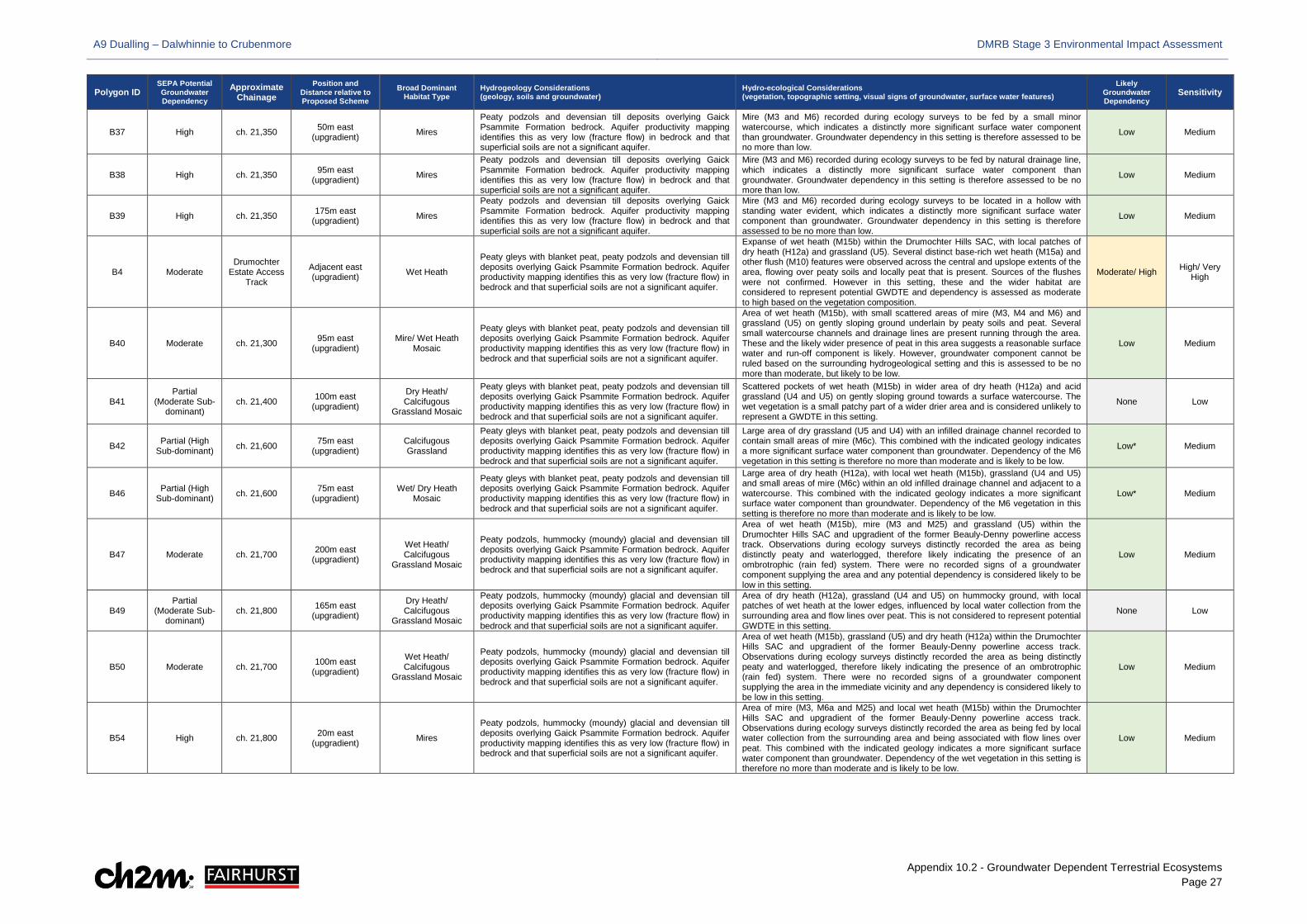
A9 Dualling – Dalwhinnie to Crubenmore DMRB Stage 3 Environmental Impact Assessment
Appendix 10.2 - Groundwater Dependent Terrestrial Ecosystems Page 27
Polygon ID SEPA Potential Groundwater Dependency
Approximate Chainage
Position and Distance relative to Proposed Scheme
Broad Dominant Habitat Type
Hydrogeology Considerations (geology, soils and groundwater)
Hydro-ecological Considerations (vegetation, topographic setting, visual signs of groundwater, surface water features)
Likely Groundwater Dependency
Sensitivity
B37 High ch. 21,350 50m east (upgradient) Mires
Peaty podzols and devensian till deposits overlying Gaick Psammite Formation bedrock. Aquifer productivity mapping identifies this as very low (fracture flow) in bedrock and that superficial soils are not a significant aquifer.
Mire (M3 and M6) recorded during ecology surveys to be fed by a small minor watercourse, which indicates a distinctly more significant surface water component than groundwater. Groundwater dependency in this setting is therefore assessed to be no more than low.
Low Medium
B38 High ch. 21,350 95m east (upgradient) Mires
Peaty podzols and devensian till deposits overlying Gaick Psammite Formation bedrock. Aquifer productivity mapping identifies this as very low (fracture flow) in bedrock and that superficial soils are not a significant aquifer.
Mire (M3 and M6) recorded during ecology surveys to be fed by natural drainage line, which indicates a distinctly more significant surface water component than groundwater. Groundwater dependency in this setting is therefore assessed to be no more than low.
Low Medium
B39 High ch. 21,350 175m east (upgradient) Mires
Peaty podzols and devensian till deposits overlying Gaick Psammite Formation bedrock. Aquifer productivity mapping identifies this as very low (fracture flow) in bedrock and that superficial soils are not a significant aquifer.
Mire (M3 and M6) recorded during ecology surveys to be located in a hollow with standing water evident, which indicates a distinctly more significant surface water component than groundwater. Groundwater dependency in this setting is therefore assessed to be no more than low.
Low Medium
B4 Moderate Drumochter
Estate Access Track
Adjacent east (upgradient) Wet Heath
Peaty gleys with blanket peat, peaty podzols and devensian till deposits overlying Gaick Psammite Formation bedrock. Aquifer productivity mapping identifies this as very low (fracture flow) in bedrock and that superficial soils are not a significant aquifer.
Expanse of wet heath (M15b) within the Drumochter Hills SAC, with local patches of dry heath (H12a) and grassland (U5). Several distinct base-rich wet heath (M15a) and other flush (M10) features were observed across the central and upslope extents of the area, flowing over peaty soils and locally peat that is present. Sources of the flushes were not confirmed. However in this setting, these and the wider habitat are considered to represent potential GWDTE and dependency is assessed as moderate to high based on the vegetation composition.
Moderate/ High High/ Very High
B40 Moderate ch. 21,300 95m east (upgradient)
Mire/ Wet Heath Mosaic
Peaty gleys with blanket peat, peaty podzols and devensian till deposits overlying Gaick Psammite Formation bedrock. Aquifer productivity mapping identifies this as very low (fracture flow) in bedrock and that superficial soils are not a significant aquifer.
Area of wet heath (M15b), with small scattered areas of mire (M3, M4 and M6) and grassland (U5) on gently sloping ground underlain by peaty soils and peat. Several small watercourse channels and drainage lines are present running through the area. These and the likely wider presence of peat in this area suggests a reasonable surface water and run-off component is likely. However, groundwater component cannot be ruled based on the surrounding hydrogeological setting and this is assessed to be no more than moderate, but likely to be low.
Low Medium
B41 Partial
(Moderate Sub-dominant)
ch. 21,400 100m east (upgradient)
Dry Heath/ Calcifugous
Grassland Mosaic
Peaty gleys with blanket peat, peaty podzols and devensian till deposits overlying Gaick Psammite Formation bedrock. Aquifer productivity mapping identifies this as very low (fracture flow) in bedrock and that superficial soils are not a significant aquifer.
Scattered pockets of wet heath (M15b) in wider area of dry heath (H12a) and acid grassland (U4 and U5) on gently sloping ground towards a surface watercourse. The wet vegetation is a small patchy part of a wider drier area and is considered unlikely to represent a GWDTE in this setting.
None Low
B42 Partial (High Sub-dominant) ch. 21,600 75m east
(upgradient) Calcifugous Grassland
Peaty gleys with blanket peat, peaty podzols and devensian till deposits overlying Gaick Psammite Formation bedrock. Aquifer productivity mapping identifies this as very low (fracture flow) in bedrock and that superficial soils are not a significant aquifer.
Large area of dry grassland (U5 and U4) with an infilled drainage channel recorded to contain small areas of mire (M6c). This combined with the indicated geology indicates a more significant surface water component than groundwater. Dependency of the M6 vegetation in this setting is therefore no more than moderate and is likely to be low.
Low* Medium
B46 Partial (High Sub-dominant) ch. 21,600 75m east
(upgradient) Wet/ Dry Heath
Mosaic
Peaty gleys with blanket peat, peaty podzols and devensian till deposits overlying Gaick Psammite Formation bedrock. Aquifer productivity mapping identifies this as very low (fracture flow) in bedrock and that superficial soils are not a significant aquifer.
Large area of dry heath (H12a), with local wet heath (M15b), grassland (U4 and U5) and small areas of mire (M6c) within an old infilled drainage channel and adjacent to a watercourse. This combined with the indicated geology indicates a more significant surface water component than groundwater. Dependency of the M6 vegetation in this setting is therefore no more than moderate and is likely to be low.
Low* Medium
B47 Moderate ch. 21,700 200m east (upgradient)
Wet Heath/ Calcifugous
Grassland Mosaic
Peaty podzols, hummocky (moundy) glacial and devensian till deposits overlying Gaick Psammite Formation bedrock. Aquifer productivity mapping identifies this as very low (fracture flow) in bedrock and that superficial soils are not a significant aquifer.
Area of wet heath (M15b), mire (M3 and M25) and grassland (U5) within the Drumochter Hills SAC and upgradient of the former Beauly-Denny powerline access track. Observations during ecology surveys distinctly recorded the area as being distinctly peaty and waterlogged, therefore likely indicating the presence of an ombrotrophic (rain fed) system. There were no recorded signs of a groundwater component supplying the area and any potential dependency is considered likely to be low in this setting.
Low Medium
B49 Partial
(Moderate Sub-dominant)
ch. 21,800 165m east (upgradient)
Dry Heath/ Calcifugous
Grassland Mosaic
Peaty podzols, hummocky (moundy) glacial and devensian till deposits overlying Gaick Psammite Formation bedrock. Aquifer productivity mapping identifies this as very low (fracture flow) in bedrock and that superficial soils are not a significant aquifer.
Area of dry heath (H12a), grassland (U4 and U5) on hummocky ground, with local patches of wet heath at the lower edges, influenced by local water collection from the surrounding area and flow lines over peat. This is not considered to represent potential GWDTE in this setting.
None Low
B50 Moderate ch. 21,700 100m east (upgradient)
Wet Heath/ Calcifugous
Grassland Mosaic
Peaty podzols, hummocky (moundy) glacial and devensian till deposits overlying Gaick Psammite Formation bedrock. Aquifer productivity mapping identifies this as very low (fracture flow) in bedrock and that superficial soils are not a significant aquifer.
Area of wet heath (M15b), grassland (U5) and dry heath (H12a) within the Drumochter Hills SAC and upgradient of the former Beauly-Denny powerline access track. Observations during ecology surveys distinctly recorded the area as being distinctly peaty and waterlogged, therefore likely indicating the presence of an ombrotrophic (rain fed) system. There were no recorded signs of a groundwater component supplying the area in the immediate vicinity and any dependency is considered likely to be low in this setting.
Low Medium
B54 High ch. 21,800 20m east (upgradient) Mires
Peaty podzols, hummocky (moundy) glacial and devensian till deposits overlying Gaick Psammite Formation bedrock. Aquifer productivity mapping identifies this as very low (fracture flow) in bedrock and that superficial soils are not a significant aquifer.
Area of mire (M3, M6a and M25) and local wet heath (M15b) within the Drumochter Hills SAC and upgradient of the former Beauly-Denny powerline access track. Observations during ecology surveys distinctly recorded the area as being fed by local water collection from the surrounding area and being associated with flow lines over peat. This combined with the indicated geology indicates a more significant surface water component than groundwater. Dependency of the wet vegetation in this setting is therefore no more than moderate and is likely to be low.
Low Medium
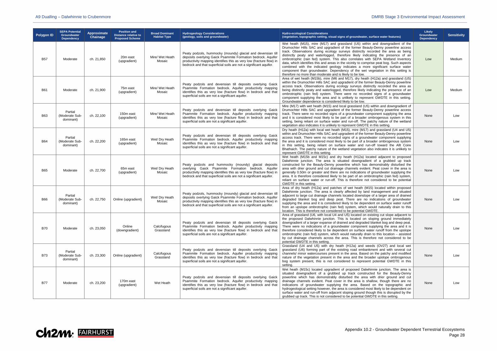
A9 Dualling – Dalwhinnie to Crubenmore DMRB Stage 3 Environmental Impact Assessment
Appendix 10.2 - Groundwater Dependent Terrestrial Ecosystems Page 28
Polygon ID SEPA Potential Groundwater Dependency
Approximate Chainage
Position and Distance relative to Proposed Scheme
Broad Dominant Habitat Type
Hydrogeology Considerations (geology, soils and groundwater)
Hydro-ecological Considerations (vegetation, topographic setting, visual signs of groundwater, surface water features)
Likely Groundwater Dependency
Sensitivity
B57 Moderate ch. 21,850 20m east (upgradient)
Mire/ Wet Heath Mosaic
Peaty podzols, hummocky (moundy) glacial and devensian till deposits overlying Gaick Psammite Formation bedrock. Aquifer productivity mapping identifies this as very low (fracture flow) in bedrock and that superficial soils are not a significant aquifer.
Wet heath (M15), mire (M17) and grassland (U5) within and downgradient of the Drumochter Hills SAC and upgradient of the former Beauly-Denny powerline access track. Observations during ecology surveys distinctly recorded the area as being distinctly peaty and waterlogged, therefore likely indicating the presence of an ombrotrophic (rain fed) system. This also correlates with SEPA Wetland Inventory data, which identifies this and areas in the vicinity to comprise peat bog. Such aspects combined with the indicated geology indicates a more significant surface water component than groundwater. Dependency of the wet vegetation in this setting is therefore no more than moderate and is likely to be low.
Low Medium
B61 Moderate ch. 21,900 75m east (upgradient)
Mire/ Wet Heath Mosaic
Peaty podzols and devensian till deposits overlying Gaick Psammite Formation bedrock. Aquifer productivity mapping identifies this as very low (fracture flow) in bedrock and that superficial soils are not a significant aquifer.
Area of wet heath (M15b), mire (M6 and M17), dry heath (H12a) and grassland (U5) within the Drumochter Hills SAC and upgradient of the former Beauly-Denny powerline access track. Observations during ecology surveys distinctly recorded the area as being distinctly peaty and waterlogged, therefore likely indicating the presence of an ombrotrophic (rain fed) system. There were no recorded signs of a groundwater component supplying the area and is unlikely to represent GWDTE in this setting. Groundwater dependence is considered likely to be low.
Low Medium
B63 Partial
(Moderate Sub-dominant)
ch. 22,100 150m east (upgradient)
Mire/ Wet Heath Mosaic
Peaty podzols and devensian till deposits overlying Gaick Psammite Formation bedrock. Aquifer productivity mapping identifies this as very low (fracture flow) in bedrock and that superficial soils are not a significant aquifer.
Mire (M17) with wet heath (M15) and local grassland (U5) within and downgradient of Drumochter Hills SAC and upgradient of the former Beauly-Denny powerline access track. There were no recorded signs of a groundwater component supplying the area and it is considered most likely to be part of a broader ombrogenous system in this setting, being reliant on surface water and run-off. The patchy nature of the wetland vegetation also indicates it is unlikely to represent GWDTE in this setting.
None Low
B64 Partial
(Moderate Sub-dominant)
ch. 22,200 165m east (upgradient)
Wet/ Dry Heath Mosaic
Peaty podzols and devensian till deposits overlying Gaick Psammite Formation bedrock. Aquifer productivity mapping identifies this as very low (fracture flow) in bedrock and that superficial soils are not a significant aquifer.
Dry heath (H12a) with local wet heath (M15), mire (M17) and grassland (U4 and U5) within and Drumochter Hills SAC and upgradient of the former Beauly-Denny powerline access track. There were no recorded signs of a groundwater component supplying the area and it is considered most likely to be part of a broader ombrogenous system in this setting, being reliant on surface water and run-off toward the Allt Coire Bhathaich. The patchy nature of the wetland vegetation also indicates it is unlikely to represent GWDTE in this setting.
None Low
B65 Moderate ch. 22,700 65m east (upgradient)
Wet/ Dry Heath Mosaic
Peaty podzols and hummocky (moundy) glacial deposits overlying Gaick Psammite Formation bedrock. Aquifer productivity mapping identifies this as very low (fracture flow) in bedrock and that superficial soils are not a significant aquifer.
Wet heath (M15b and M15c) and dry heath (H12a) located adjacent to proposed Dalwhinnie junction. The area is situated downgradient of a grubbed up track constructed for the Beauly-Denny powerline which has demonstrably disturbed the area with drier ground and cut drainage channels evident. Peat cover in the area is generally 0.50m or greater and there are no indications of groundwater supplying the area. It is therefore considered likely to be part of an ombrotrophic (rain fed) system, reliant on surface water or run-off. This is therefore not considered to be potential GWDTE in this setting.
None Low
B66 Partial
(Moderate Sub-dominant)
ch. 22,750 Online (upgradient) Wet/ Dry Heath Mosaic
Peaty podzols, hummocky (moundy) glacial and devensian till deposits overlying Gaick Psammite Formation bedrock. Aquifer productivity mapping identifies this as very low (fracture flow) in bedrock and that superficial soils are not a significant aquifer.
Area of dry heath (H12a) and patches of wet heath (M15) located within proposed Dalwhinnie junction. The area is clearly affected by land management and situated adjacent to large cut drainage channels located downslope of a larger area of drained degraded blanket bog and deep peat. There are no indications of groundwater supplying the area and it is considered likely to be dependent on surface water runoff from an upslope ombrotrophic (rain fed) system, which would naturally drain to this location. This is therefore not considered to be potential GWDTE.
None Low
B70 Moderate ch. 23,050 Online (downgradient)
Calcifugous Grassland
Peaty podzols and devensian till deposits overlying Gaick Psammite Formation bedrock. Aquifer productivity mapping identifies this as very low (fracture flow) in bedrock and that superficial soils are not a significant aquifer.
Area of grassland (U6, with local U4 and U5) located on existing cut slope adjacent to the proposed Dalwhinnie junction. This is located on sloping ground immediately downgradient of a larger expanse of drained and degraded blanket bog and deep peat. There were no indications of a groundwater component supplying the area and it is therefore considered likely to be dependent on surface water runoff from the upslope ombrotrophic (rain fed) system, which would naturally drain to this location – assisted by cut drainage channels across the area. This is therefore not considered to be potential GWDTE in this setting.
None Low
B73 Partial
(Moderate Sub-dominant)
ch. 23,300 Online (upgradient) Calcifugous Grassland
Peaty podzols and devensian till deposits overlying Gaick Psammite Formation bedrock. Aquifer productivity mapping identifies this as very low (fracture flow) in bedrock and that superficial soils are not a significant aquifer.
Grassland (U4 and U5) with dry heath (H12a) and weeds (OV27) and local wet grassland (U6) forming part of the existing road embankment and with several cut channels/ minor watercourses present in the area. Based on the patchy and modified nature of the vegetation present in the area and the broader upslope ombrogenous bog system present, this is not considered to represent potential GWDTE in this setting.
None Low
B77 Moderate ch. 23,200 170m east (upgradient) Wet Heath
Peaty podzols and devensian till deposits overlying Gaick Psammite Formation bedrock. Aquifer productivity mapping identifies this as very low (fracture flow) in bedrock and that superficial soils are not a significant aquifer.
Wet heath (M15c) located upgradient of proposed Dalwhinnie junction. The area is situated downgradient of a grubbed up track constructed for the Beauly-Denny powerline which has demonstrably disturbed the area with drier ground and cut drainage channels evident. Peat cover in the area is shallow, though there are no indications of groundwater supplying the area. Based on the topographic and hydrogeological setting however, the area is considered most likely to be dependent on surface water and run-off from adjacent sloping ground though this is disrupted by the grubbed up track. This is not considered to be potential GWDTE in this setting.
None Low
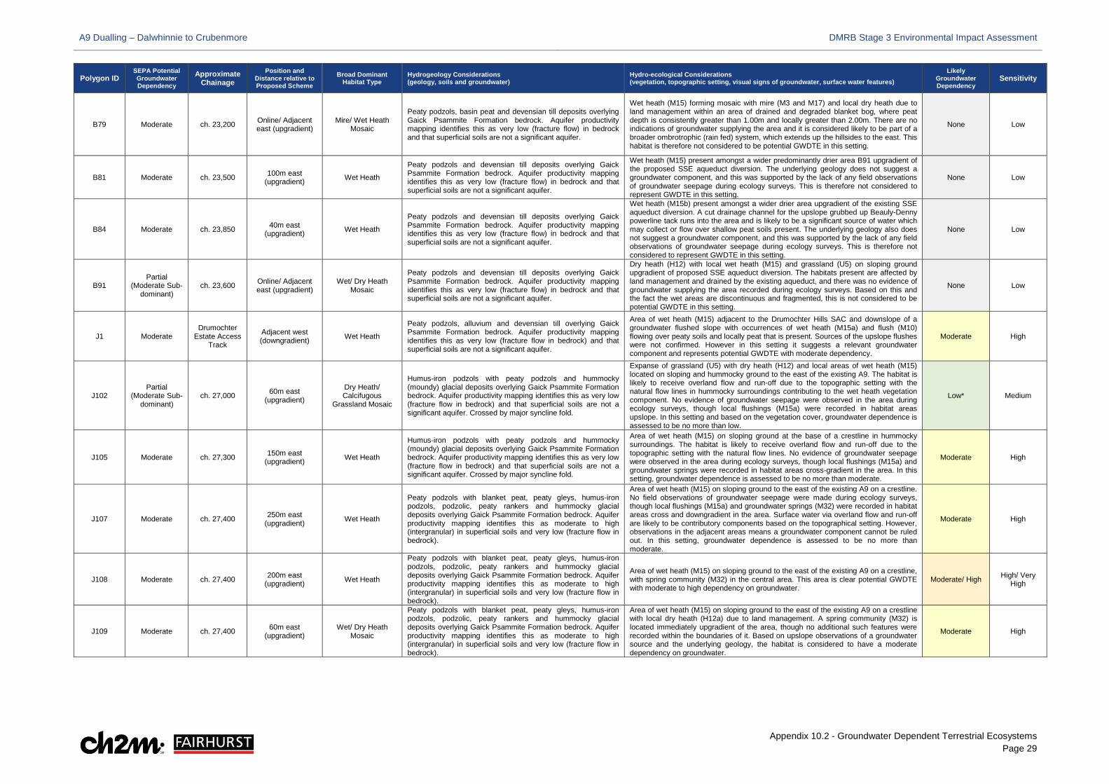
A9 Dualling – Dalwhinnie to Crubenmore DMRB Stage 3 Environmental Impact Assessment
Appendix 10.2 - Groundwater Dependent Terrestrial Ecosystems Page 29
Polygon ID SEPA Potential Groundwater Dependency
Approximate Chainage
Position and Distance relative to Proposed Scheme
Broad Dominant Habitat Type
Hydrogeology Considerations (geology, soils and groundwater)
Hydro-ecological Considerations (vegetation, topographic setting, visual signs of groundwater, surface water features)
Likely Groundwater Dependency
Sensitivity
B79 Moderate ch. 23,200 Online/ Adjacent east (upgradient)
Mire/ Wet Heath Mosaic
Peaty podzols, basin peat and devensian till deposits overlying Gaick Psammite Formation bedrock. Aquifer productivity mapping identifies this as very low (fracture flow) in bedrock and that superficial soils are not a significant aquifer.
Wet heath (M15) forming mosaic with mire (M3 and M17) and local dry heath due to land management within an area of drained and degraded blanket bog, where peat depth is consistently greater than 1.00m and locally greater than 2.00m. There are no indications of groundwater supplying the area and it is considered likely to be part of a broader ombrotrophic (rain fed) system, which extends up the hillsides to the east. This habitat is therefore not considered to be potential GWDTE in this setting.
None Low
B81 Moderate ch. 23,500 100m east (upgradient) Wet Heath
Peaty podzols and devensian till deposits overlying Gaick Psammite Formation bedrock. Aquifer productivity mapping identifies this as very low (fracture flow) in bedrock and that superficial soils are not a significant aquifer.
Wet heath (M15) present amongst a wider predominantly drier area B91 upgradient of the proposed SSE aqueduct diversion. The underlying geology does not suggest a groundwater component, and this was supported by the lack of any field observations of groundwater seepage during ecology surveys. This is therefore not considered to represent GWDTE in this setting.
None Low
B84 Moderate ch. 23,850 40m east (upgradient) Wet Heath
Peaty podzols and devensian till deposits overlying Gaick Psammite Formation bedrock. Aquifer productivity mapping identifies this as very low (fracture flow) in bedrock and that superficial soils are not a significant aquifer.
Wet heath (M15b) present amongst a wider drier area upgradient of the existing SSE aqueduct diversion. A cut drainage channel for the upslope grubbed up Beauly-Denny powerline tack runs into the area and is likely to be a significant source of water which may collect or flow over shallow peat soils present. The underlying geology also does not suggest a groundwater component, and this was supported by the lack of any field observations of groundwater seepage during ecology surveys. This is therefore not considered to represent GWDTE in this setting.
None Low
B91 Partial
(Moderate Sub-dominant)
ch. 23,600 Online/ Adjacent east (upgradient)
Wet/ Dry Heath Mosaic
Peaty podzols and devensian till deposits overlying Gaick Psammite Formation bedrock. Aquifer productivity mapping identifies this as very low (fracture flow) in bedrock and that superficial soils are not a significant aquifer.
Dry heath (H12) with local wet heath (M15) and grassland (U5) on sloping ground upgradient of proposed SSE aqueduct diversion. The habitats present are affected by land management and drained by the existing aqueduct, and there was no evidence of groundwater supplying the area recorded during ecology surveys. Based on this and the fact the wet areas are discontinuous and fragmented, this is not considered to be potential GWDTE in this setting.
None Low
J1 Moderate Drumochter
Estate Access Track
Adjacent west (downgradient) Wet Heath
Peaty podzols, alluvium and devensian till overlying Gaick Psammite Formation bedrock. Aquifer productivity mapping identifies this as very low (fracture flow in bedrock) and that superficial soils are not a significant aquifer.
Area of wet heath (M15) adjacent to the Drumochter Hills SAC and downslope of a groundwater flushed slope with occurrences of wet heath (M15a) and flush (M10) flowing over peaty soils and locally peat that is present. Sources of the upslope flushes were not confirmed. However in this setting it suggests a relevant groundwater component and represents potential GWDTE with moderate dependency.
Moderate High
J102 Partial
(Moderate Sub-dominant)
ch. 27,000 60m east (upgradient)
Dry Heath/ Calcifugous
Grassland Mosaic
Humus-iron podzols with peaty podzols and hummocky (moundy) glacial deposits overlying Gaick Psammite Formation bedrock. Aquifer productivity mapping identifies this as very low (fracture flow in bedrock) and that superficial soils are not a significant aquifer. Crossed by major syncline fold.
Expanse of grassland (U5) with dry heath (H12) and local areas of wet heath (M15) located on sloping and hummocky ground to the east of the existing A9. The habitat is likely to receive overland flow and run-off due to the topographic setting with the natural flow lines in hummocky surroundings contributing to the wet heath vegetation component. No evidence of groundwater seepage were observed in the area during ecology surveys, though local flushings (M15a) were recorded in habitat areas upslope. In this setting and based on the vegetation cover, groundwater dependence is assessed to be no more than low.
Low* Medium
J105 Moderate ch. 27,300 150m east (upgradient) Wet Heath
Humus-iron podzols with peaty podzols and hummocky (moundy) glacial deposits overlying Gaick Psammite Formation bedrock. Aquifer productivity mapping identifies this as very low (fracture flow in bedrock) and that superficial soils are not a significant aquifer. Crossed by major syncline fold.
Area of wet heath (M15) on sloping ground at the base of a crestline in hummocky surroundings. The habitat is likely to receive overland flow and run-off due to the topographic setting with the natural flow lines. No evidence of groundwater seepage were observed in the area during ecology surveys, though local flushings (M15a) and groundwater springs were recorded in habitat areas cross-gradient in the area. In this setting, groundwater dependence is assessed to be no more than moderate.
Moderate High
J107 Moderate ch. 27,400 250m east (upgradient) Wet Heath
Peaty podzols with blanket peat, peaty gleys, humus-iron podzols, podzolic, peaty rankers and hummocky glacial deposits overlying Gaick Psammite Formation bedrock. Aquifer productivity mapping identifies this as moderate to high (intergranular) in superficial soils and very low (fracture flow in bedrock).
Area of wet heath (M15) on sloping ground to the east of the existing A9 on a crestline. No field observations of groundwater seepage were made during ecology surveys, though local flushings (M15a) and groundwater springs (M32) were recorded in habitat areas cross and downgradient in the area. Surface water via overland flow and run-off are likely to be contributory components based on the topographical setting. However, observations in the adjacent areas means a groundwater component cannot be ruled out. In this setting, groundwater dependence is assessed to be no more than moderate.
Moderate High
J108 Moderate ch. 27,400 200m east (upgradient) Wet Heath
Peaty podzols with blanket peat, peaty gleys, humus-iron podzols, podzolic, peaty rankers and hummocky glacial deposits overlying Gaick Psammite Formation bedrock. Aquifer productivity mapping identifies this as moderate to high (intergranular) in superficial soils and very low (fracture flow in bedrock).
Area of wet heath (M15) on sloping ground to the east of the existing A9 on a crestline, with spring community (M32) in the central area. This area is clear potential GWDTE with moderate to high dependency on groundwater.
Moderate/ High High/ Very High
J109 Moderate ch. 27,400 60m east (upgradient)
Wet/ Dry Heath Mosaic
Peaty podzols with blanket peat, peaty gleys, humus-iron podzols, podzolic, peaty rankers and hummocky glacial deposits overlying Gaick Psammite Formation bedrock. Aquifer productivity mapping identifies this as moderate to high (intergranular) in superficial soils and very low (fracture flow in bedrock).
Area of wet heath (M15) on sloping ground to the east of the existing A9 on a crestline with local dry heath (H12a) due to land management. A spring community (M32) is located immediately upgradient of the area, though no additional such features were recorded within the boundaries of it. Based on upslope observations of a groundwater source and the underlying geology, the habitat is considered to have a moderate dependency on groundwater.
Moderate High

A9 Dualling – Dalwhinnie to Crubenmore DMRB Stage 3 Environmental Impact Assessment
Appendix 10.2 - Groundwater Dependent Terrestrial Ecosystems Page 30
Polygon ID SEPA Potential Groundwater Dependency
Approximate Chainage
Position and Distance relative to Proposed Scheme
Broad Dominant Habitat Type
Hydrogeology Considerations (geology, soils and groundwater)
Hydro-ecological Considerations (vegetation, topographic setting, visual signs of groundwater, surface water features)
Likely Groundwater Dependency
Sensitivity
J11 Moderate ch. 20,150 Online/ Adjacent east (upgradient) Mires
Peaty podzols, alluvial fan and devensian till overlying Gaick Psammite Formation bedrock. Aquifer productivity mapping identifies this as moderate to high (intergranular) in superficial soils and very low (fracture flow in bedrock).
Degraded blanket bog (M25) on waterlogged and level ground in winter resilience plantation ride. The area is likely to be supplied by surface water and run-off from upslope, instances of which are noted to have a groundwater origin within the Drumochter Hills SAC. This supply is also likely to be affected by water uptake due to the winter resilience plantation, though conditions remain waterlogged. Based on this and due to the distance between the spring sources and the bog area, and additional likely contributions of surface water runoff or precipitation, the habitat is considered only to have a low dependency on groundwater inputs.
Low Medium
J111 Moderate ch. 27,150 Online/ Adjacent east (upgradient)
Wet/ Dry Heath Mosaic
Mineral alluvial soils, with peaty alluvial soils, peaty podzols, blanket peat, peaty gleys, glaciofluvial and hummocky (moundy) glacial deposits overlying Gaick Psammite Formation bedrock. Aquifer productivity mapping identifies this as moderate to high (intergranular) in superficial soils and very low (fracture flow in bedrock).
Wet heath (M15), dry heath (H16) and grassland (U5) located on sloping ground immediately to the east of an existing cut slope on the A9. The habitat is likely to receive overland flow and run-off due to the topographic setting with upslope hummocky surroundings creating natural flow lines towards this. No evidence of groundwater seepage were observed in the area during ecology surveys, though local flushings (M15a) and springs (M32) were recorded in habitat areas further upslope. In this setting and based on the vegetation cover, groundwater dependence is assessed to be no more than moderate.
Moderate High
J114 Moderate ch. 27,350 50m east (upgradient)
Mire/ Wet Heath Mosaic
Peaty podzols with blanket peat, peaty gleys, humus-iron podzols and hummocky (moundy) glacial deposits overlying Gaick Psammite Formation bedrock. Aquifer productivity mapping identifies this as moderate to high (intergranular) in superficial soils and very low (fracture flow in bedrock).
Wet heath (M15), local mire (M25) and grassland (U5) located on sloping ground immediately to the east of an existing cut slope on the A9. The habitat is likely to receive overland flow and run-off due to the topographic setting, though is also immediately downgradient of two recorded springs (M32) in J108 and J115. In this setting and based on the vegetation cover, groundwater dependence is assessed to be moderate.
Moderate High
J115 High ch. 27,300 175m east (upgradient) Mires
Humus-iron podzols with peaty podzols and hummocky (moundy) glacial deposits overlying Gaick Psammite Formation bedrock. Aquifer productivity mapping identifies this as very low (fracture flow in bedrock) and that superficial soils are not a significant aquifer.
Spring community (M32) located below a crestline and above a fault to the east of the existing A9, representing clear GWDTE with high groundwater dependence. High Very High
J116 Partial
(Moderate Sub-dominant)
ch. 29,700 Online/ Adjacent east
Dry Heath/ Calcifugous
Grassland Mosaic
Peaty podzols with blanket peat, peaty gleys, hummocky (moundy) glacial, glaciofluvial and ardverikie till deposits overlying Gaick Psammite Formation bedrock. Aquifer productivity mapping identifies this as very low (fracture flow in bedrock) and that superficial soils are not a significant aquifer.
Expanse of dry heath (H12 and H16), grassland (U4) and very local mire (M25) comprising existing cut slope for the A9. Flushed slopes are present immediately upslope of the area but on the basis that this comprises the existing road cutting and wet vegetation comprises such a small fragmented component part, it is not considered to represent potential GWDTE in this setting.
None Low
J118 Moderate ch. 30,100 Adjacent east (upgradient) Wet Heath
Peaty podzols with podzolic rankers with peaty rankers, humus-iron podzols, mineral alluvial soils, peaty alluvial soils, ardverikie till and hummocky (moundy) glacial deposits overlying Gaick Psammite Formation bedrock. Aquifer productivity mapping identifies this as very low (facture flow) in bedrock and not a significant aquifer in superficial soils.
Large area of wet heath (M15) on sloping ground to the east of the existing A9 and immediately downgradient of J167, where channelised groundwater spring flow is evident. There is no ground investigation or groundwater depth information available for the area, but based on the vegetation cover and upslope observations, the habitat is considered to be GWDTE with a moderate to high dependency on groundwater in this setting.
Moderate/ High High/ Very High
J12 High Drumochter
Estate Access Track
Adjacent west (downgradient) Mires
Peaty gleys with blanket peat, peaty podzols and devensian till overlying Gaick Psammite Formation bedrock. Aquifer productivity mapping identifies this as very low (fracture flow in bedrock) and that superficial soils are not a significant aquifer.
Area of mire (M6) downgradient of existing Beauly-Denny powerline access track. Distinct wet heath flushings (M15a) were observed in the area as well as adjacent to it upslope in B12, these flowing over peaty soils and locally peat. Sources of the flushes were not confirmed. However in this setting, this is considered to represent potential GWDTE and dependency is assessed as high based on the vegetation cover.
Moderate High
J124 Moderate ch. 29,900 Online/ adjacent east (upgradient) Wet Heath
Peaty podzols with podzolic rankers, peaty rankers and hummocky (moundy) glacial deposits overlying Gaick Psammite Formation bedrock. Aquifer productivity mapping identifies this as very low (facture flow) in bedrock and not a significant aquifer in superficial soils. Downgradient of major syncline fold.
Wet heath (M15) located adjacent to the east of existing A9 at the top of a cut slope with minor watercourse channels present through the area and overlying pockets of shallow and deep peat. The habitat is likely to receive overland flow and run-off due to the topographic setting, but the presence of folding upslope and distinct groundwater supplies in the surrounding area indicate that there is also potential for a groundwater component to supply the area. Based on the vegetation, dependency for this habitat in this setting is however considered to be low.
Low Medium
J125 Partial
(Moderate Sub-dominant)
ch. 29,900 Online/ adjacent east (upgradient)
Wet/ Dry Heath Mosaic
Peaty podzols with podzolic rankers, peaty rankers and hummocky (moundy) glacial deposits overlying Gaick Psammite Formation bedrock. Aquifer productivity mapping identifies this as very low (facture flow) in bedrock and not a significant aquifer in superficial soils. Downgradient of major syncline fold.
Area of dry heath (H12) and wet heath (M15) located adjacent to the east of J124. The habitat is likely to receive overland flow and run-off due to the topographic setting, but the presence of folding upslope and distinct groundwater supplies in the surrounding area indicate that there is also potential for a groundwater component to supply the area. Based on the vegetation cover of the area, dependency for this habitat in this setting is considered to be low.
Low* Medium
J127 Moderate ch. 29,900 30m east (upgradient) Dry Heath
Peaty podzols with podzolic rankers, peaty rankers and hummocky (moundy) glacial deposits overlying Gaick Psammite Formation bedrock. Aquifer productivity mapping identifies this as very low (facture flow) in bedrock and not a significant aquifer in superficial soils. Downgradient of major syncline fold.
Area of wet heath (M15) located adjacent to the east of J125. The habitat is likely to receive overland flow and run-off due to the topographic setting, but the presence of folding upslope and distinct groundwater supplies in the surrounding area indicate that there is also potential for a groundwater component to supply the area. Based on the vegetation cover of the area, dependency for this habitat in this setting is considered to be moderate.
Moderate High
J128 Moderate ch. 29,800 Online/ adjacent east (upgradient)
Wet Heath/ Calcifugous
Grassland Mosaic
Peaty podzols with blanket peat, peaty gleys, podzolic rankers, peaty rankers, hummocky (moundy) glacial deposits and ardverikie till overlying Gaick Psammite Formation bedrock. Aquifer productivity mapping identifies this as very low (facture flow) in bedrock and not a significant aquifer in superficial soils. Downgradient of major syncline fold.
Area of wet heath (M15) located adjacent to the west and south of J127. The habitat is likely to receive overland flow and run-off due to the topographic setting, but the presence of folding upslope and distinct groundwater supplies in the surrounding area indicate that there is also potential for a groundwater component to supply the area. Based on the vegetation cover of the area, dependency for this habitat in this setting is considered to be moderate.
Moderate High
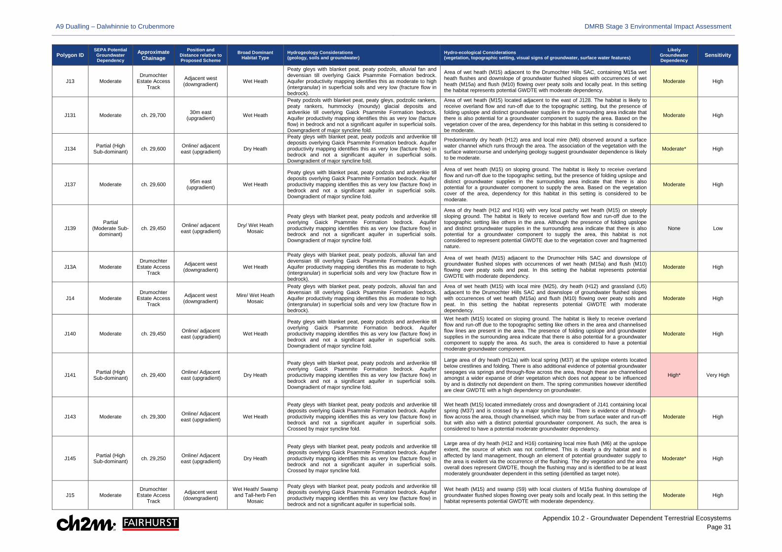
A9 Dualling – Dalwhinnie to Crubenmore DMRB Stage 3 Environmental Impact Assessment
Appendix 10.2 - Groundwater Dependent Terrestrial Ecosystems Page 31
Polygon ID SEPA Potential Groundwater Dependency
Approximate Chainage
Position and Distance relative to Proposed Scheme
Broad Dominant Habitat Type
Hydrogeology Considerations (geology, soils and groundwater)
Hydro-ecological Considerations (vegetation, topographic setting, visual signs of groundwater, surface water features)
Likely Groundwater Dependency
Sensitivity
J13 Moderate Drumochter
Estate Access Track
Adjacent west (downgradient) Wet Heath
Peaty gleys with blanket peat, peaty podzols, alluvial fan and devensian till overlying Gaick Psammite Formation bedrock. Aquifer productivity mapping identifies this as moderate to high (intergranular) in superficial soils and very low (fracture flow in bedrock).
Area of wet heath (M15) adjacent to the Drumochter Hills SAC, containing M15a wet heath flushes and downslope of groundwater flushed slopes with occurrences of wet heath (M15a) and flush (M10) flowing over peaty soils and locally peat. In this setting the habitat represents potential GWDTE with moderate dependency.
Moderate High
J131 Moderate ch. 29,700 30m east (upgradient) Wet Heath
Peaty podzols with blanket peat, peaty gleys, podzolic rankers, peaty rankers, hummocky (moundy) glacial deposits and ardverikie till overlying Gaick Psammite Formation bedrock. Aquifer productivity mapping identifies this as very low (facture flow) in bedrock and not a significant aquifer in superficial soils. Downgradient of major syncline fold.
Area of wet heath (M15) located adjacent to the east of J128. The habitat is likely to receive overland flow and run-off due to the topographic setting, but the presence of folding upslope and distinct groundwater supplies in the surrounding area indicate that there is also potential for a groundwater component to supply the area. Based on the vegetation cover of the area, dependency for this habitat in this setting is considered to be moderate.
Moderate High
J134 Partial (High Sub-dominant) ch. 29,600 Online/ adjacent
east (upgradient) Dry Heath
Peaty gleys with blanket peat, peaty podzols and ardverikie till deposits overlying Gaick Psammite Formation bedrock. Aquifer productivity mapping identifies this as very low (facture flow) in bedrock and not a significant aquifer in superficial soils. Downgradient of major syncline fold.
Predominantly dry heath (H12) area and local mire (M6) observed around a surface water channel which runs through the area. The association of the vegetation with the surface watercourse and underlying geology suggest groundwater dependence is likely to be moderate.
Moderate* High
J137 Moderate ch. 29,600 95m east (upgradient) Wet Heath
Peaty gleys with blanket peat, peaty podzols and ardverikie till deposits overlying Gaick Psammite Formation bedrock. Aquifer productivity mapping identifies this as very low (facture flow) in bedrock and not a significant aquifer in superficial soils. Downgradient of major syncline fold.
Area of wet heath (M15) on sloping ground. The habitat is likely to receive overland flow and run-off due to the topographic setting, but the presence of folding upslope and distinct groundwater supplies in the surrounding area indicate that there is also potential for a groundwater component to supply the area. Based on the vegetation cover of the area, dependency for this habitat in this setting is considered to be moderate.
Moderate High
J139 Partial
(Moderate Sub-dominant)
ch. 29,450 Online/ adjacent east (upgradient)
Dry/ Wet Heath Mosaic
Peaty gleys with blanket peat, peaty podzols and ardverikie till overlying Gaick Psammite Formation bedrock. Aquifer productivity mapping identifies this as very low (facture flow) in bedrock and not a significant aquifer in superficial soils. Downgradient of major syncline fold.
Area of dry heath (H12 and H16) with very local patchy wet heath (M15) on steeply sloping ground. The habitat is likely to receive overland flow and run-off due to the topographic setting like others in the area. Although the presence of folding upslope and distinct groundwater supplies in the surrounding area indicate that there is also potential for a groundwater component to supply the area, this habitat is not considered to represent potential GWDTE due to the vegetation cover and fragmented nature.
None Low
J13A Moderate Drumochter
Estate Access Track
Adjacent west (downgradient) Wet Heath
Peaty gleys with blanket peat, peaty podzols, alluvial fan and devensian till overlying Gaick Psammite Formation bedrock. Aquifer productivity mapping identifies this as moderate to high (intergranular) in superficial soils and very low (fracture flow in bedrock).
Area of wet heath (M15) adjacent to the Drumochter Hills SAC and downslope of groundwater flushed slopes with occurrences of wet heath (M15a) and flush (M10) flowing over peaty soils and peat. In this setting the habitat represents potential GWDTE with moderate dependency.
Moderate High
J14 Moderate Drumochter
Estate Access Track
Adjacent west (downgradient)
Mire/ Wet Heath Mosaic
Peaty gleys with blanket peat, peaty podzols, alluvial fan and devensian till overlying Gaick Psammite Formation bedrock. Aquifer productivity mapping identifies this as moderate to high (intergranular) in superficial soils and very low (fracture flow in bedrock).
Area of wet heath (M15) with local mire (M25), dry heath (H12) and grassland (U5) adjacent to the Drumochter Hills SAC and downslope of groundwater flushed slopes with occurrences of wet heath (M15a) and flush (M10) flowing over peaty soils and peat. In this setting the habitat represents potential GWDTE with moderate dependency.
Moderate High
J140 Moderate ch. 29,450 Online/ adjacent east (upgradient) Wet Heath
Peaty gleys with blanket peat, peaty podzols and ardverikie till overlying Gaick Psammite Formation bedrock. Aquifer productivity mapping identifies this as very low (facture flow) in bedrock and not a significant aquifer in superficial soils. Downgradient of major syncline fold.
Wet heath (M15) located on sloping ground. The habitat is likely to receive overland flow and run-off due to the topographic setting like others in the area and channelised flow lines are present in the area. The presence of folding upslope and groundwater supplies in the surrounding area indicate that there is also potential for a groundwater component to supply the area. As such, the area is considered to have a potential moderate groundwater component.
Moderate High
J141 Partial (High Sub-dominant) ch. 29,400 Online/ Adjacent
east (upgradient) Dry Heath
Peaty gleys with blanket peat, peaty podzols and ardverikie till overlying Gaick Psammite Formation bedrock. Aquifer productivity mapping identifies this as very low (facture flow) in bedrock and not a significant aquifer in superficial soils. Downgradient of major syncline fold.
Large area of dry heath (H12a) with local spring (M37) at the upslope extents located below crestlines and folding. There is also additional evidence of potential groundwater seepages via springs and through-flow across the area, though these are channelised amongst a wider expanse of drier vegetation which does not appear to be influenced by and is distinctly not dependent on them. The spring communities however identified are clear GWDTE with a high dependency on groundwater.
High* Very High
J143 Moderate ch. 29,300 Online/ Adjacent east (upgradient) Wet Heath
Peaty gleys with blanket peat, peaty podzols and ardverikie till deposits overlying Gaick Psammite Formation bedrock. Aquifer productivity mapping identifies this as very low (facture flow) in bedrock and not a significant aquifer in superficial soils. Crossed by major syncline fold.
Wet heath (M15) located immediately cross and downgradient of J141 containing local spring (M37) and is crossed by a major syncline fold. There is evidence of through-flow across the area, though channelised, which may be from surface water and run-off but with also with a distinct potential groundwater component. As such, the area is considered to have a potential moderate groundwater dependency.
Moderate High
J145 Partial (High Sub-dominant) ch. 29,250 Online/ Adjacent
east (upgradient) Dry Heath
Peaty gleys with blanket peat, peaty podzols and ardverikie till deposits overlying Gaick Psammite Formation bedrock. Aquifer productivity mapping identifies this as very low (facture flow) in bedrock and not a significant aquifer in superficial soils. Crossed by major syncline fold.
Large area of dry heath (H12 and H16) containing local mire flush (M6) at the upslope extent, the source of which was not confirmed. This is clearly a dry habitat and is affected by land management, though an element of potential groundwater supply to the area is evident via the occurrence of the flushing. The dry vegetation and the area overall does represent GWDTE, though the flushing may and is identified to be at least moderately groundwater dependent in this setting (identified as target note).
Moderate* High
J15 Moderate Drumochter
Estate Access Track
Adjacent west (downgradient)
Wet Heath/ Swamp and Tall-herb Fen
Mosaic
Peaty gleys with blanket peat, peaty podzols and ardverikie till deposits overlying Gaick Psammite Formation bedrock. Aquifer productivity mapping identifies this as very low (facture flow) in bedrock and not a significant aquifer in superficial soils.
Wet heath (M15) and swamp (S9) with local clusters of M15a flushing downslope of groundwater flushed slopes flowing over peaty soils and locally peat. In this setting the habitat represents potential GWDTE with moderate dependency.
Moderate High
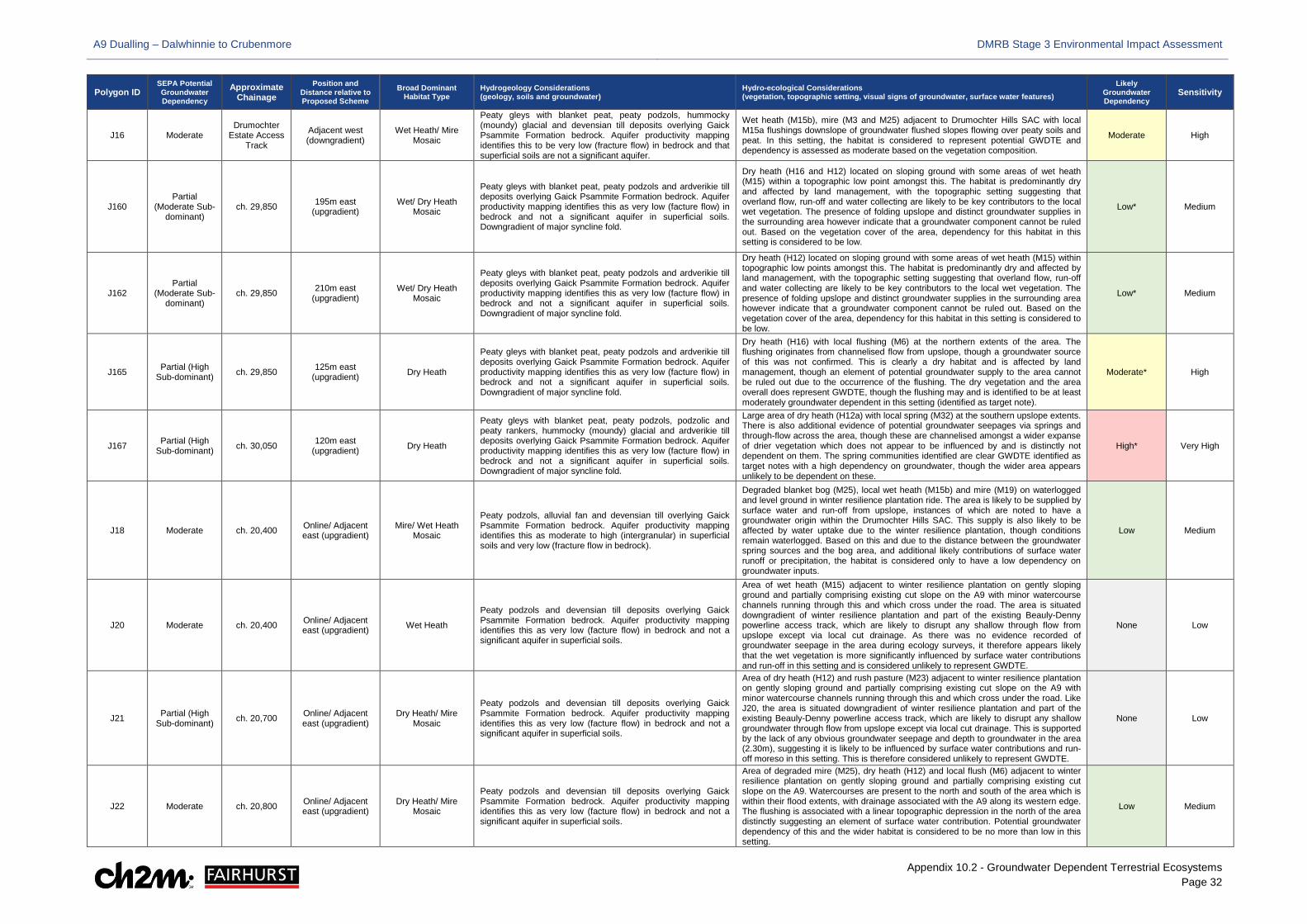
A9 Dualling – Dalwhinnie to Crubenmore DMRB Stage 3 Environmental Impact Assessment
Appendix 10.2 - Groundwater Dependent Terrestrial Ecosystems Page 32
Polygon ID SEPA Potential Groundwater Dependency
Approximate Chainage
Position and Distance relative to Proposed Scheme
Broad Dominant Habitat Type
Hydrogeology Considerations (geology, soils and groundwater)
Hydro-ecological Considerations (vegetation, topographic setting, visual signs of groundwater, surface water features)
Likely Groundwater Dependency
Sensitivity
J16 Moderate Drumochter
Estate Access Track
Adjacent west (downgradient)
Wet Heath/ Mire Mosaic
Peaty gleys with blanket peat, peaty podzols, hummocky (moundy) glacial and devensian till deposits overlying Gaick Psammite Formation bedrock. Aquifer productivity mapping identifies this to be very low (fracture flow) in bedrock and that superficial soils are not a significant aquifer.
Wet heath (M15b), mire (M3 and M25) adjacent to Drumochter Hills SAC with local M15a flushings downslope of groundwater flushed slopes flowing over peaty soils and peat. In this setting, the habitat is considered to represent potential GWDTE and dependency is assessed as moderate based on the vegetation composition.
Moderate High
J160 Partial
(Moderate Sub-dominant)
ch. 29,850 195m east (upgradient)
Wet/ Dry Heath Mosaic
Peaty gleys with blanket peat, peaty podzols and ardverikie till deposits overlying Gaick Psammite Formation bedrock. Aquifer productivity mapping identifies this as very low (facture flow) in bedrock and not a significant aquifer in superficial soils. Downgradient of major syncline fold.
Dry heath (H16 and H12) located on sloping ground with some areas of wet heath (M15) within a topographic low point amongst this. The habitat is predominantly dry and affected by land management, with the topographic setting suggesting that overland flow, run-off and water collecting are likely to be key contributors to the local wet vegetation. The presence of folding upslope and distinct groundwater supplies in the surrounding area however indicate that a groundwater component cannot be ruled out. Based on the vegetation cover of the area, dependency for this habitat in this setting is considered to be low.
Low* Medium
J162 Partial
(Moderate Sub-dominant)
ch. 29,850 210m east (upgradient)
Wet/ Dry Heath Mosaic
Peaty gleys with blanket peat, peaty podzols and ardverikie till deposits overlying Gaick Psammite Formation bedrock. Aquifer productivity mapping identifies this as very low (facture flow) in bedrock and not a significant aquifer in superficial soils. Downgradient of major syncline fold.
Dry heath (H12) located on sloping ground with some areas of wet heath (M15) within topographic low points amongst this. The habitat is predominantly dry and affected by land management, with the topographic setting suggesting that overland flow, run-off and water collecting are likely to be key contributors to the local wet vegetation. The presence of folding upslope and distinct groundwater supplies in the surrounding area however indicate that a groundwater component cannot be ruled out. Based on the vegetation cover of the area, dependency for this habitat in this setting is considered to be low.
Low* Medium
J165 Partial (High Sub-dominant) ch. 29,850 125m east
(upgradient) Dry Heath
Peaty gleys with blanket peat, peaty podzols and ardverikie till deposits overlying Gaick Psammite Formation bedrock. Aquifer productivity mapping identifies this as very low (facture flow) in bedrock and not a significant aquifer in superficial soils. Downgradient of major syncline fold.
Dry heath (H16) with local flushing (M6) at the northern extents of the area. The flushing originates from channelised flow from upslope, though a groundwater source of this was not confirmed. This is clearly a dry habitat and is affected by land management, though an element of potential groundwater supply to the area cannot be ruled out due to the occurrence of the flushing. The dry vegetation and the area overall does represent GWDTE, though the flushing may and is identified to be at least moderately groundwater dependent in this setting (identified as target note).
Moderate* High
J167 Partial (High Sub-dominant) ch. 30,050 120m east
(upgradient) Dry Heath
Peaty gleys with blanket peat, peaty podzols, podzolic and peaty rankers, hummocky (moundy) glacial and ardverikie till deposits overlying Gaick Psammite Formation bedrock. Aquifer productivity mapping identifies this as very low (facture flow) in bedrock and not a significant aquifer in superficial soils. Downgradient of major syncline fold.
Large area of dry heath (H12a) with local spring (M32) at the southern upslope extents. There is also additional evidence of potential groundwater seepages via springs and through-flow across the area, though these are channelised amongst a wider expanse of drier vegetation which does not appear to be influenced by and is distinctly not dependent on them. The spring communities identified are clear GWDTE identified as target notes with a high dependency on groundwater, though the wider area appears unlikely to be dependent on these.
High* Very High
J18 Moderate ch. 20,400 Online/ Adjacent east (upgradient)
Mire/ Wet Heath Mosaic
Peaty podzols, alluvial fan and devensian till overlying Gaick Psammite Formation bedrock. Aquifer productivity mapping identifies this as moderate to high (intergranular) in superficial soils and very low (fracture flow in bedrock).
Degraded blanket bog (M25), local wet heath (M15b) and mire (M19) on waterlogged and level ground in winter resilience plantation ride. The area is likely to be supplied by surface water and run-off from upslope, instances of which are noted to have a groundwater origin within the Drumochter Hills SAC. This supply is also likely to be affected by water uptake due to the winter resilience plantation, though conditions remain waterlogged. Based on this and due to the distance between the groundwater spring sources and the bog area, and additional likely contributions of surface water runoff or precipitation, the habitat is considered only to have a low dependency on groundwater inputs.
Low Medium
J20 Moderate ch. 20,400 Online/ Adjacent east (upgradient) Wet Heath
Peaty podzols and devensian till deposits overlying Gaick Psammite Formation bedrock. Aquifer productivity mapping identifies this as very low (facture flow) in bedrock and not a significant aquifer in superficial soils.
Area of wet heath (M15) adjacent to winter resilience plantation on gently sloping ground and partially comprising existing cut slope on the A9 with minor watercourse channels running through this and which cross under the road. The area is situated downgradient of winter resilience plantation and part of the existing Beauly-Denny powerline access track, which are likely to disrupt any shallow through flow from upslope except via local cut drainage. As there was no evidence recorded of groundwater seepage in the area during ecology surveys, it therefore appears likely that the wet vegetation is more significantly influenced by surface water contributions and run-off in this setting and is considered unlikely to represent GWDTE.
None Low
J21 Partial (High Sub-dominant) ch. 20,700 Online/ Adjacent
east (upgradient) Dry Heath/ Mire
Mosaic
Peaty podzols and devensian till deposits overlying Gaick Psammite Formation bedrock. Aquifer productivity mapping identifies this as very low (facture flow) in bedrock and not a significant aquifer in superficial soils.
Area of dry heath (H12) and rush pasture (M23) adjacent to winter resilience plantation on gently sloping ground and partially comprising existing cut slope on the A9 with minor watercourse channels running through this and which cross under the road. Like J20, the area is situated downgradient of winter resilience plantation and part of the existing Beauly-Denny powerline access track, which are likely to disrupt any shallow groundwater through flow from upslope except via local cut drainage. This is supported by the lack of any obvious groundwater seepage and depth to groundwater in the area (2.30m), suggesting it is likely to be influenced by surface water contributions and run-off moreso in this setting. This is therefore considered unlikely to represent GWDTE.
None Low
J22 Moderate ch. 20,800 Online/ Adjacent east (upgradient)
Dry Heath/ Mire Mosaic
Peaty podzols and devensian till deposits overlying Gaick Psammite Formation bedrock. Aquifer productivity mapping identifies this as very low (facture flow) in bedrock and not a significant aquifer in superficial soils.
Area of degraded mire (M25), dry heath (H12) and local flush (M6) adjacent to winter resilience plantation on gently sloping ground and partially comprising existing cut slope on the A9. Watercourses are present to the north and south of the area which is within their flood extents, with drainage associated with the A9 along its western edge. The flushing is associated with a linear topographic depression in the north of the area distinctly suggesting an element of surface water contribution. Potential groundwater dependency of this and the wider habitat is considered to be no more than low in this setting.
Low Medium
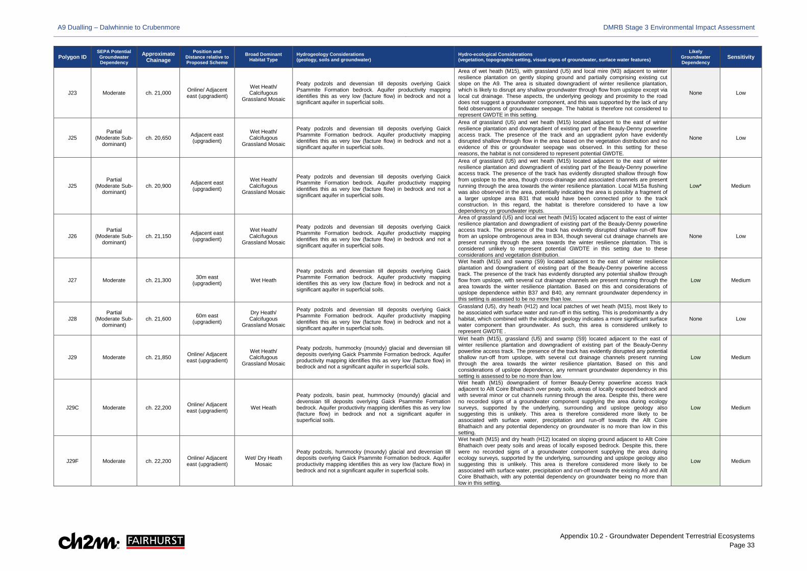
A9 Dualling – Dalwhinnie to Crubenmore DMRB Stage 3 Environmental Impact Assessment
Appendix 10.2 - Groundwater Dependent Terrestrial Ecosystems Page 33
Polygon ID SEPA Potential Groundwater Dependency
Approximate Chainage
Position and Distance relative to Proposed Scheme
Broad Dominant Habitat Type
Hydrogeology Considerations (geology, soils and groundwater)
Hydro-ecological Considerations (vegetation, topographic setting, visual signs of groundwater, surface water features)
Likely Groundwater Dependency
Sensitivity
J23 Moderate ch. 21,000 Online/ Adjacent east (upgradient)
Wet Heath/ Calcifugous
Grassland Mosaic
Peaty podzols and devensian till deposits overlying Gaick Psammite Formation bedrock. Aquifer productivity mapping identifies this as very low (facture flow) in bedrock and not a significant aquifer in superficial soils.
Area of wet heath (M15), with grassland (U5) and local mire (M3) adjacent to winter resilience plantation on gently sloping ground and partially comprising existing cut slope on the A9. The area is situated downgradient of winter resilience plantation, which is likely to disrupt any shallow groundwater through flow from upslope except via local cut drainage. These aspects, the underlying geology and proximity to the road does not suggest a groundwater component, and this was supported by the lack of any field observations of groundwater seepage. The habitat is therefore not considered to represent GWDTE in this setting.
None Low
J25 Partial
(Moderate Sub-dominant)
ch. 20,650 Adjacent east (upgradient)
Wet Heath/ Calcifugous
Grassland Mosaic
Peaty podzols and devensian till deposits overlying Gaick Psammite Formation bedrock. Aquifer productivity mapping identifies this as very low (facture flow) in bedrock and not a significant aquifer in superficial soils.
Area of grassland (U5) and wet heath (M15) located adjacent to the east of winter resilience plantation and downgradient of existing part of the Beauly-Denny powerline access track. The presence of the track and an upgradient pylon have evidently disrupted shallow through flow in the area based on the vegetation distribution and no evidence of this or groundwater seepage was observed. In this setting for these reasons, the habitat is not considered to represent potential GWDTE.
None Low
J25 Partial
(Moderate Sub-dominant)
ch. 20,900 Adjacent east (upgradient)
Wet Heath/ Calcifugous
Grassland Mosaic
Peaty podzols and devensian till deposits overlying Gaick Psammite Formation bedrock. Aquifer productivity mapping identifies this as very low (facture flow) in bedrock and not a significant aquifer in superficial soils.
Area of grassland (U5) and wet heath (M15) located adjacent to the east of winter resilience plantation and downgradient of existing part of the Beauly-Denny powerline access track. The presence of the track has evidently disrupted shallow through flow from upslope to the area, though cross-drainage and associated channels are present running through the area towards the winter resilience plantation. Local M15a flushing was also observed in the area, potentially indicating the area is possibly a fragment of a larger upslope area B31 that would have been connected prior to the track construction. In this regard, the habitat is therefore considered to have a low dependency on groundwater inputs.
Low* Medium
J26 Partial
(Moderate Sub-dominant)
ch. 21,150 Adjacent east (upgradient)
Wet Heath/ Calcifugous
Grassland Mosaic
Peaty podzols and devensian till deposits overlying Gaick Psammite Formation bedrock. Aquifer productivity mapping identifies this as very low (facture flow) in bedrock and not a significant aquifer in superficial soils.
Area of grassland (U5) and local wet heath (M15) located adjacent to the east of winter resilience plantation and downgradient of existing part of the Beauly-Denny powerline access track. The presence of the track has evidently disrupted shallow run-off flow from an upslope ombrogenous area in B34, though several cut drainage channels are present running through the area towards the winter resilience plantation. This is considered unlikely to represent potential GWDTE in this setting due to these considerations and vegetation distribution.
None Low
J27 Moderate ch. 21,300 30m east (upgradient) Wet Heath
Peaty podzols and devensian till deposits overlying Gaick Psammite Formation bedrock. Aquifer productivity mapping identifies this as very low (facture flow) in bedrock and not a significant aquifer in superficial soils.
Wet heath (M15) and swamp (S9) located adjacent to the east of winter resilience plantation and downgradient of existing part of the Beauly-Denny powerline access track. The presence of the track has evidently disrupted any potential shallow through flow from upslope, with several cut drainage channels are present running through the area towards the winter resilience plantation. Based on this and considerations of upslope dependence within B37 and B40, any remnant groundwater dependency in this setting is assessed to be no more than low.
Low Medium
J28 Partial
(Moderate Sub-dominant)
ch. 21,600 60m east (upgradient)
Dry Heath/ Calcifugous
Grassland Mosaic
Peaty podzols and devensian till deposits overlying Gaick Psammite Formation bedrock. Aquifer productivity mapping identifies this as very low (facture flow) in bedrock and not a significant aquifer in superficial soils.
Grassland (U5), dry heath (H12) and local patches of wet heath (M15), most likely to be associated with surface water and run-off in this setting. This is predominantly a dry habitat, which combined with the indicated geology indicates a more significant surface water component than groundwater. As such, this area is considered unlikely to represent GWDTE .
None Low
J29 Moderate ch. 21,850 Online/ Adjacent east (upgradient)
Wet Heath/ Calcifugous
Grassland Mosaic
Peaty podzols, hummocky (moundy) glacial and devensian till deposits overlying Gaick Psammite Formation bedrock. Aquifer productivity mapping identifies this as very low (facture flow) in bedrock and not a significant aquifer in superficial soils.
Wet heath (M15), grassland (U5) and swamp (S9) located adjacent to the east of winter resilience plantation and downgradient of existing part of the Beauly-Denny powerline access track. The presence of the track has evidently disrupted any potential shallow run-off from upslope, with several cut drainage channels present running through the area towards the winter resilience plantation. Based on this and considerations of upslope dependence, any remnant groundwater dependency in this setting is assessed to be no more than low.
Low Medium
J29C Moderate ch. 22,200 Online/ Adjacent east (upgradient) Wet Heath
Peaty podzols, basin peat, hummocky (moundy) glacial and devensian till deposits overlying Gaick Psammite Formation bedrock. Aquifer productivity mapping identifies this as very low (facture flow) in bedrock and not a significant aquifer in superficial soils.
Wet heath (M15) downgradient of former Beauly-Denny powerline access track adjacent to Allt Coire Bhathaich over peaty soils, areas of locally exposed bedrock and with several minor or cut channels running through the area. Despite this, there were no recorded signs of a groundwater component supplying the area during ecology surveys, supported by the underlying, surrounding and upslope geology also suggesting this is unlikely. This area is therefore considered more likely to be associated with surface water, precipitation and run-off towards the Allt Coire Bhathaich and any potential dependency on groundwater is no more than low in this setting.
Low Medium
J29F Moderate ch. 22,200 Online/ Adjacent east (upgradient)
Wet/ Dry Heath Mosaic
Peaty podzols, hummocky (moundy) glacial and devensian till deposits overlying Gaick Psammite Formation bedrock. Aquifer productivity mapping identifies this as very low (facture flow) in bedrock and not a significant aquifer in superficial soils.
Wet heath (M15) and dry heath (H12) located on sloping ground adjacent to Allt Coire Bhathaich over peaty soils and areas of locally exposed bedrock. Despite this, there were no recorded signs of a groundwater component supplying the area during ecology surveys, supported by the underlying, surrounding and upslope geology also suggesting this is unlikely. This area is therefore considered more likely to be associated with surface water, precipitation and run-off towards the existing A9 and Allt Coire Bhathaich, with any potential dependency on groundwater being no more than low in this setting.
Low Medium
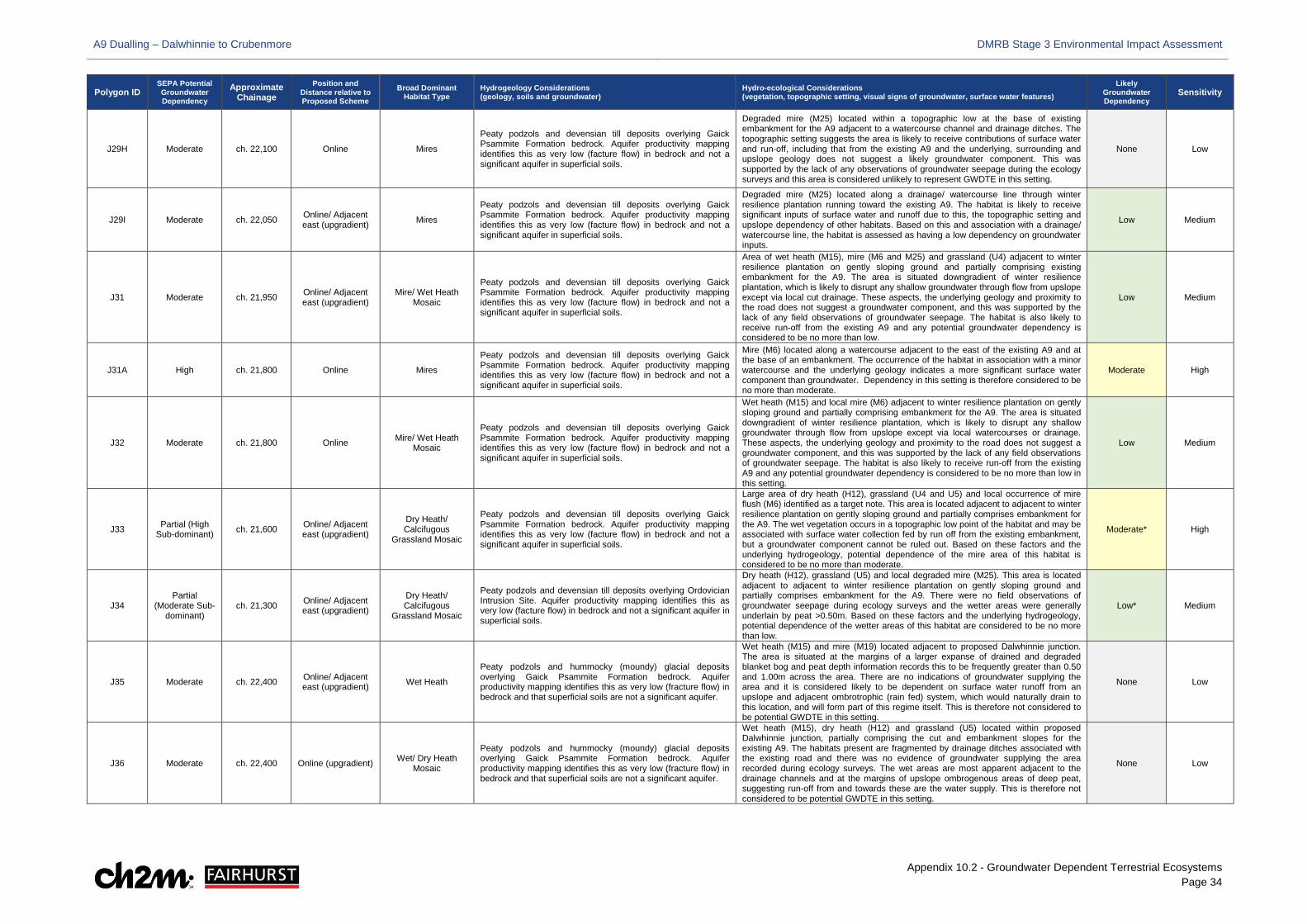
A9 Dualling – Dalwhinnie to Crubenmore DMRB Stage 3 Environmental Impact Assessment
Appendix 10.2 - Groundwater Dependent Terrestrial Ecosystems Page 34
Polygon ID SEPA Potential Groundwater Dependency
Approximate Chainage
Position and Distance relative to Proposed Scheme
Broad Dominant Habitat Type
Hydrogeology Considerations (geology, soils and groundwater)
Hydro-ecological Considerations (vegetation, topographic setting, visual signs of groundwater, surface water features)
Likely Groundwater Dependency
Sensitivity
J29H Moderate ch. 22,100 Online Mires
Peaty podzols and devensian till deposits overlying Gaick Psammite Formation bedrock. Aquifer productivity mapping identifies this as very low (facture flow) in bedrock and not a significant aquifer in superficial soils.
Degraded mire (M25) located within a topographic low at the base of existing embankment for the A9 adjacent to a watercourse channel and drainage ditches. The topographic setting suggests the area is likely to receive contributions of surface water and run-off, including that from the existing A9 and the underlying, surrounding and upslope geology does not suggest a likely groundwater component. This was supported by the lack of any observations of groundwater seepage during the ecology surveys and this area is considered unlikely to represent GWDTE in this setting.
None Low
J29I Moderate ch. 22,050 Online/ Adjacent east (upgradient) Mires
Peaty podzols and devensian till deposits overlying Gaick Psammite Formation bedrock. Aquifer productivity mapping identifies this as very low (facture flow) in bedrock and not a significant aquifer in superficial soils.
Degraded mire (M25) located along a drainage/ watercourse line through winter resilience plantation running toward the existing A9. The habitat is likely to receive significant inputs of surface water and runoff due to this, the topographic setting and upslope dependency of other habitats. Based on this and association with a drainage/ watercourse line, the habitat is assessed as having a low dependency on groundwater inputs.
Low Medium
J31 Moderate ch. 21,950 Online/ Adjacent east (upgradient)
Mire/ Wet Heath Mosaic
Peaty podzols and devensian till deposits overlying Gaick Psammite Formation bedrock. Aquifer productivity mapping identifies this as very low (facture flow) in bedrock and not a significant aquifer in superficial soils.
Area of wet heath (M15), mire (M6 and M25) and grassland (U4) adjacent to winter resilience plantation on gently sloping ground and partially comprising existing embankment for the A9. The area is situated downgradient of winter resilience plantation, which is likely to disrupt any shallow groundwater through flow from upslope except via local cut drainage. These aspects, the underlying geology and proximity to the road does not suggest a groundwater component, and this was supported by the lack of any field observations of groundwater seepage. The habitat is also likely to receive run-off from the existing A9 and any potential groundwater dependency is considered to be no more than low.
Low Medium
J31A High ch. 21,800 Online Mires
Peaty podzols and devensian till deposits overlying Gaick Psammite Formation bedrock. Aquifer productivity mapping identifies this as very low (facture flow) in bedrock and not a significant aquifer in superficial soils.
Mire (M6) located along a watercourse adjacent to the east of the existing A9 and at the base of an embankment. The occurrence of the habitat in association with a minor watercourse and the underlying geology indicates a more significant surface water component than groundwater. Dependency in this setting is therefore considered to be no more than moderate.
Moderate High
J32 Moderate ch. 21,800 Online Mire/ Wet Heath Mosaic
Peaty podzols and devensian till deposits overlying Gaick Psammite Formation bedrock. Aquifer productivity mapping identifies this as very low (facture flow) in bedrock and not a significant aquifer in superficial soils.
Wet heath (M15) and local mire (M6) adjacent to winter resilience plantation on gently sloping ground and partially comprising embankment for the A9. The area is situated downgradient of winter resilience plantation, which is likely to disrupt any shallow groundwater through flow from upslope except via local watercourses or drainage. These aspects, the underlying geology and proximity to the road does not suggest a groundwater component, and this was supported by the lack of any field observations of groundwater seepage. The habitat is also likely to receive run-off from the existing A9 and any potential groundwater dependency is considered to be no more than low in this setting.
Low Medium
J33 Partial (High Sub-dominant) ch. 21,600 Online/ Adjacent
east (upgradient)
Dry Heath/ Calcifugous
Grassland Mosaic
Peaty podzols and devensian till deposits overlying Gaick Psammite Formation bedrock. Aquifer productivity mapping identifies this as very low (facture flow) in bedrock and not a significant aquifer in superficial soils.
Large area of dry heath (H12), grassland (U4 and U5) and local occurrence of mire flush (M6) identified as a target note. This area is located adjacent to adjacent to winter resilience plantation on gently sloping ground and partially comprises embankment for the A9. The wet vegetation occurs in a topographic low point of the habitat and may be associated with surface water collection fed by run off from the existing embankment, but a groundwater component cannot be ruled out. Based on these factors and the underlying hydrogeology, potential dependence of the mire area of this habitat is considered to be no more than moderate.
Moderate* High
J34 Partial
(Moderate Sub-dominant)
ch. 21,300 Online/ Adjacent east (upgradient)
Dry Heath/ Calcifugous
Grassland Mosaic
Peaty podzols and devensian till deposits overlying Ordovician Intrusion Site. Aquifer productivity mapping identifies this as very low (facture flow) in bedrock and not a significant aquifer in superficial soils.
Dry heath (H12), grassland (U5) and local degraded mire (M25). This area is located adjacent to adjacent to winter resilience plantation on gently sloping ground and partially comprises embankment for the A9. There were no field observations of groundwater seepage during ecology surveys and the wetter areas were generally underlain by peat >0.50m. Based on these factors and the underlying hydrogeology, potential dependence of the wetter areas of this habitat are considered to be no more than low.
Low* Medium
J35 Moderate ch. 22,400 Online/ Adjacent east (upgradient) Wet Heath
Peaty podzols and hummocky (moundy) glacial deposits overlying Gaick Psammite Formation bedrock. Aquifer productivity mapping identifies this as very low (fracture flow) in bedrock and that superficial soils are not a significant aquifer.
Wet heath (M15) and mire (M19) located adjacent to proposed Dalwhinnie junction. The area is situated at the margins of a larger expanse of drained and degraded blanket bog and peat depth information records this to be frequently greater than 0.50 and 1.00m across the area. There are no indications of groundwater supplying the area and it is considered likely to be dependent on surface water runoff from an upslope and adjacent ombrotrophic (rain fed) system, which would naturally drain to this location, and will form part of this regime itself. This is therefore not considered to be potential GWDTE in this setting.
None Low
J36 Moderate ch. 22,400 Online (upgradient) Wet/ Dry Heath Mosaic
Peaty podzols and hummocky (moundy) glacial deposits overlying Gaick Psammite Formation bedrock. Aquifer productivity mapping identifies this as very low (fracture flow) in bedrock and that superficial soils are not a significant aquifer.
Wet heath (M15), dry heath (H12) and grassland (U5) located within proposed Dalwhinnie junction, partially comprising the cut and embankment slopes for the existing A9. The habitats present are fragmented by drainage ditches associated with the existing road and there was no evidence of groundwater supplying the area recorded during ecology surveys. The wet areas are most apparent adjacent to the drainage channels and at the margins of upslope ombrogenous areas of deep peat, suggesting run-off from and towards these are the water supply. This is therefore not considered to be potential GWDTE in this setting.
None Low
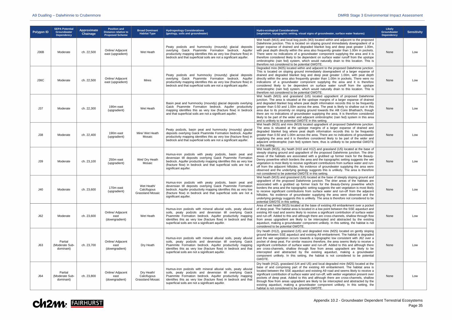
A9 Dualling – Dalwhinnie to Crubenmore DMRB Stage 3 Environmental Impact Assessment
Appendix 10.2 - Groundwater Dependent Terrestrial Ecosystems Page 35
Polygon ID SEPA Potential Groundwater Dependency
Approximate Chainage
Position and Distance relative to Proposed Scheme
Broad Dominant Habitat Type
Hydrogeology Considerations (geology, soils and groundwater)
Hydro-ecological Considerations (vegetation, topographic setting, visual signs of groundwater, surface water features)
Likely Groundwater Dependency
Sensitivity
J36B Moderate ch. 22,500 Online/ Adjacent east (upgradient) Wet Heath
Peaty podzols and hummocky (moundy) glacial deposits overlying Gaick Psammite Formation bedrock. Aquifer productivity mapping identifies this as very low (fracture flow) in bedrock and that superficial soils are not a significant aquifer.
Wet heath (M15) and local bog pools (M3) located within and adjacent to the proposed Dalwhinnie junction. This is located on sloping ground immediately downgradient of a larger expanse of drained and degraded blanket bog and deep peat greater 1.00m, with peat depth directly within the area also frequently greater than 1.00m in pockets. There were no indications of a groundwater component supplying the area and it is therefore considered likely to be dependent on surface water runoff from the upslope ombrotrophic (rain fed) system, which would naturally drain to this location. This is therefore not considered to be potential GWDTE.
None Low
J36C Moderate ch. 22,500 Online/ Adjacent east (upgradient) Mires
Peaty podzols and hummocky (moundy) glacial deposits overlying Gaick Psammite Formation bedrock. Aquifer productivity mapping identifies this as very low (fracture flow) in bedrock and that superficial soils are not a significant aquifer.
Degraded mire (M25) located within and adjacent to the proposed Dalwhinnie junction. This is located on sloping ground immediately downgradient of a larger expanse of drained and degraded blanket bog and deep peat greater 1.00m, with peat depth directly within the area also frequently greater than 1.00m in pockets. There were no indications of a groundwater component supplying the area and it is therefore considered likely to be dependent on surface water runoff from the upslope ombrotrophic (rain fed) system, which would naturally drain to this location. This is therefore not considered to be potential GWDTE.
None Low
J37 Moderate ch. 22,300 190m east (upgradient) Wet Heath
Basin peat and hummocky (moundy) glacial deposits overlying Gaick Psammite Formation bedrock. Aquifer productivity mapping identifies this as very low (fracture flow) in bedrock and that superficial soils are not a significant aquifer.
Wet heath (M15) and grassland (U5) located upgradient of proposed Dalwhinnie junction. The area is situated at the upslope margins of a larger expanse of drained and degraded blanket bog where peat depth information records this to be frequently greater than 0.50 and 1.00m across the area. The peat is likely to shallow out in this area due to its proximity on sloping ground towards the Allt Coire Bhathaich, though there are no indications of groundwater supplying the area. It is therefore considered likely to be part of the wider and adjacent ombrotrophic (rain fed) system in this area and is unlikely to be potential GWDTE in this setting.
None Low
J38 Moderate ch. 22,400 190m east (upgradient)
Mire/ Wet Heath Mosaic
Peaty podzols, basin peat and hummocky (moundy) glacial deposits overlying Gaick Psammite Formation bedrock. Aquifer productivity mapping identifies this as very low (fracture flow) in bedrock and that superficial soils are not a significant aquifer.
Wet heath (M15) and mire (M19) located upgradient of proposed Dalwhinnie junction. The area is situated at the upslope margins of a larger expanse of drained and degraded blanket bog where peat depth information records this to be frequently greater than 0.50 and 1.00m across the area. There are no indications of groundwater supplying the area and it is therefore considered likely to be part of the wider and adjacent ombrotrophic (rain fed) system here, thus is unlikely to be potential GWDTE in this setting.
None Low
J39 Moderate ch. 23,100 250m east (upgradient)
Wet/ Dry Heath Mosaic
Humus-iron podzols with peaty podzols, basin peat and devensian till deposits overlying Gaick Psammite Formation bedrock. Aquifer productivity mapping identifies this as very low (fracture flow) in bedrock and that superficial soils are not a significant aquifer.
Wet heath (M15), dry heath (H10 and H12) and grassland (U5) located at the base of steeply sloping ground and upgradient of the proposed Dalwhinnie junction. The drier areas of the habitats are associated with a grubbed up former track for the Beauly-Denny powerline which borders the area and the topographic setting suggests the wet vegetation is most likely to receive significant contributions from surface water and run-off from the adjacent hillsides. No evidence of groundwater supplying the area were observed and the underlying geology suggests this is unlikely. The area is therefore not considered to be potential GWDTE in this setting.
None Low
J40 Moderate ch. 23,600 170m east (upgradient)
Wet Heath/ Calcifugous
Grassland Mosaic
Humus-iron podzols with peaty podzols, basin peat and devensian till deposits overlying Gaick Psammite Formation bedrock. Aquifer productivity mapping identifies this as very low (fracture flow) in bedrock and that superficial soils are not a significant aquifer.
Wet heath (M15) and grassland (U5) located at the base of steeply sloping ground and upgradient of the proposed Dalwhinnie junction. The drier areas of the habitats are associated with a grubbed up former track for the Beauly-Denny powerline which borders the area and the topographic setting suggests the wet vegetation is most likely to receive significant contributions from surface water and run-off from the adjacent hillsides. No evidence of groundwater supplying the area were observed and the underlying geology suggests this is unlikely. The area is therefore not considered to be potential GWDTE in this setting.
None Low
J62 Moderate ch. 23,600 Online/ Adjacent
east (downgradient)
Wet Heath
Humus-iron podzols with mineral alluvial soils, peaty alluvial soils, peaty podzols and devensian till overlying Gaick Psammite Formation bedrock. Aquifer productivity mapping identifies this as very low (fracture flow) in bedrock and that superficial soils are not a significant aquifer.
Area of wet heath (M15) located at the base of existing A9 embankment over a pocket of deep peat. The habitat area is located in a low point between the SSE aqueduct and existing A9 road and seems likely to receive a significant contribution of surface water and run-off. Added to this and although there are cross-channels, shallow through flow from areas upgradient are likely to be intercepted and abstracted by the existing aqueduct, making a groundwater component unlikely. In this setting, the habitat is not considered to be potential GWDTE.
None Low
J63 Partial
(Moderate Sub-dominant)
ch. 23,700 Online/ Adjacent
east (downgradient)
Dry Heath
Humus-iron podzols with mineral alluvial soils, peaty alluvial soils, peaty podzols and devensian till overlying Gaick Psammite Formation bedrock. Aquifer productivity mapping identifies this as very low (fracture flow) in bedrock and that superficial soils are not a significant aquifer.
Dry heath (H12), grassland (U5) and degraded mire (M25) located on gently sloping ground between SSE aqueduct and existing A9 embankment. The habitat is degraded and the wet vegetation occurs towards a topographic low consistent with J62 over a pocket of deep peat. For similar reasons therefore, the area seems likely to receive a significant contribution of surface water and run-off. Added to this and although there are cross-channels, shallow through flow from areas upgradient are likely to be intercepted and abstracted by the existing aqueduct, making a groundwater component unlikely. In this setting, the habitat is not considered to be potential GWDTE.
None Low
J64 Partial
(Moderate Sub-dominant)
ch. 23,800 Online/ Adjacent
east (downgradient)
Dry Heath/ Calcifugous
Grassland Mosaic
Humus-iron podzols with mineral alluvial soils, peaty alluvial soils, peaty podzols and devensian till overlying Gaick Psammite Formation bedrock. Aquifer productivity mapping identifies this as very low (fracture flow) in bedrock and that superficial soils are not a significant aquifer.
Dry heath (H12), grassland (U4 and U5) and local degraded mire (M25) located at the base of and comprising part of the existing A9 embankment. The habitat area is located between the SSE aqueduct and existing A9 road and seems likely to receive a significant contribution of surface water and run-off, with wetter vegetation present over pockets of deep peat. Added to this and although there are cross-channels, shallow through flow from areas upgradient are likely to be intercepted and abstracted by the existing aqueduct, making a groundwater component unlikely. In this setting, the habitat is not considered to be potential GWDTE.
None Low
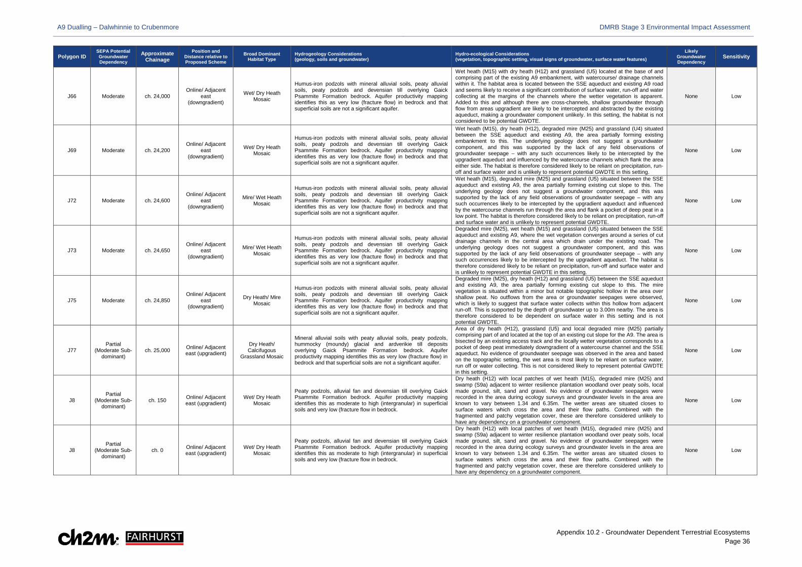
A9 Dualling – Dalwhinnie to Crubenmore DMRB Stage 3 Environmental Impact Assessment
Appendix 10.2 - Groundwater Dependent Terrestrial Ecosystems Page 36
Polygon ID SEPA Potential Groundwater Dependency
Approximate Chainage
Position and Distance relative to Proposed Scheme
Broad Dominant Habitat Type
Hydrogeology Considerations (geology, soils and groundwater)
Hydro-ecological Considerations (vegetation, topographic setting, visual signs of groundwater, surface water features)
Likely Groundwater Dependency
Sensitivity
J66 Moderate ch. 24,000 Online/ Adjacent
east (downgradient)
Wet/ Dry Heath Mosaic
Humus-iron podzols with mineral alluvial soils, peaty alluvial soils, peaty podzols and devensian till overlying Gaick Psammite Formation bedrock. Aquifer productivity mapping identifies this as very low (fracture flow) in bedrock and that superficial soils are not a significant aquifer.
Wet heath (M15) with dry heath (H12) and grassland (U5) located at the base of and comprising part of the existing A9 embankment, with watercourse/ drainage channels within it. The habitat area is located between the SSE aqueduct and existing A9 road and seems likely to receive a significant contribution of surface water, run-off and water collecting at the margins of the channels where the wetter vegetation is apparent. Added to this and although there are cross-channels, shallow groundwater through flow from areas upgradient are likely to be intercepted and abstracted by the existing aqueduct, making a groundwater component unlikely. In this setting, the habitat is not considered to be potential GWDTE.
None Low
J69 Moderate ch. 24,200 Online/ Adjacent
east (downgradient)
Wet/ Dry Heath Mosaic
Humus-iron podzols with mineral alluvial soils, peaty alluvial soils, peaty podzols and devensian till overlying Gaick Psammite Formation bedrock. Aquifer productivity mapping identifies this as very low (fracture flow) in bedrock and that superficial soils are not a significant aquifer.
Wet heath (M15), dry heath (H12), degraded mire (M25) and grassland (U4) situated between the SSE aqueduct and existing A9, the area partially forming existing embankment to this. The underlying geology does not suggest a groundwater component, and this was supported by the lack of any field observations of groundwater seepage – with any such occurrences likely to be intercepted by the upgradient aqueduct and influenced by the watercourse channels which flank the area either side. The habitat is therefore considered likely to be reliant on precipitation, run-off and surface water and is unlikely to represent potential GWDTE in this setting.
None Low
J72 Moderate ch. 24,600 Online/ Adjacent
east (downgradient)
Mire/ Wet Heath Mosaic
Humus-iron podzols with mineral alluvial soils, peaty alluvial soils, peaty podzols and devensian till overlying Gaick Psammite Formation bedrock. Aquifer productivity mapping identifies this as very low (fracture flow) in bedrock and that superficial soils are not a significant aquifer.
Wet heath (M15), degraded mire (M25) and grassland (U5) situated between the SSE aqueduct and existing A9, the area partially forming existing cut slope to this. The underlying geology does not suggest a groundwater component, and this was supported by the lack of any field observations of groundwater seepage – with any such occurrences likely to be intercepted by the upgradient aqueduct and influenced by the watercourse channels run through the area and flank a pocket of deep peat in a low point. The habitat is therefore considered likely to be reliant on precipitation, run-off and surface water and is unlikely to represent potential GWDTE.
None Low
J73 Moderate ch. 24,650 Online/ Adjacent
east (downgradient)
Mire/ Wet Heath Mosaic
Humus-iron podzols with mineral alluvial soils, peaty alluvial soils, peaty podzols and devensian till overlying Gaick Psammite Formation bedrock. Aquifer productivity mapping identifies this as very low (fracture flow) in bedrock and that superficial soils are not a significant aquifer.
Degraded mire (M25), wet heath (M15) and grassland (U5) situated between the SSE aqueduct and existing A9, where the wet vegetation converges around a series of cut drainage channels in the central area which drain under the existing road. The underlying geology does not suggest a groundwater component, and this was supported by the lack of any field observations of groundwater seepage – with any such occurrences likely to be intercepted by the upgradient aqueduct. The habitat is therefore considered likely to be reliant on precipitation, run-off and surface water and is unlikely to represent potential GWDTE in this setting.
None Low
J75 Moderate ch. 24,850 Online/ Adjacent
east (downgradient)
Dry Heath/ Mire Mosaic
Humus-iron podzols with mineral alluvial soils, peaty alluvial soils, peaty podzols and devensian till overlying Gaick Psammite Formation bedrock. Aquifer productivity mapping identifies this as very low (fracture flow) in bedrock and that superficial soils are not a significant aquifer.
Degraded mire (M25), dry heath (H12) and grassland (U5) between the SSE aqueduct and existing A9, the area partially forming existing cut slope to this. The mire vegetation is situated within a minor but notable topographic hollow in the area over shallow peat. No outflows from the area or groundwater seepages were observed, which is likely to suggest that surface water collects within this hollow from adjacent run-off. This is supported by the depth of groundwater up to 3.00m nearby. The area is therefore considered to be dependent on surface water in this setting and is not potential GWDTE.
None Low
J77 Partial
(Moderate Sub-dominant)
ch. 25,000 Online/ Adjacent east (upgradient)
Dry Heath/ Calcifugous
Grassland Mosaic
Mineral alluvial soils with peaty alluvial soils, peaty podzols, hummocky (moundy) glacial and ardverikie till deposits overlying Gaick Psammite Formation bedrock. Aquifer productivity mapping identifies this as very low (fracture flow) in bedrock and that superficial soils are not a significant aquifer.
Area of dry heath (H12), grassland (U5) and local degraded mire (M25) partially comprising part of and located at the top of an existing cut slope for the A9. The area is bisected by an existing access track and the locally wetter vegetation corresponds to a pocket of deep peat immediately downgradient of a watercourse channel and the SSE aqueduct. No evidence of groundwater seepage was observed in the area and based on the topographic setting, the wet area is most likely to be reliant on surface water, run off or water collecting. This is not considered likely to represent potential GWDTE in this setting.
None Low
J8 Partial
(Moderate Sub-dominant)
ch. 150 Online/ Adjacent east (upgradient)
Wet/ Dry Heath Mosaic
Peaty podzols, alluvial fan and devensian till overlying Gaick Psammite Formation bedrock. Aquifer productivity mapping identifies this as moderate to high (intergranular) in superficial soils and very low (fracture flow in bedrock.
Dry heath (H12) with local patches of wet heath (M15), degraded mire (M25) and swamp (S9a) adjacent to winter resilience plantation woodland over peaty soils, local made ground, silt, sand and gravel. No evidence of groundwater seepages were recorded in the area during ecology surveys and groundwater levels in the area are known to vary between 1.34 and 6.35m. The wetter areas are situated closes to surface waters which cross the area and their flow paths. Combined with the fragmented and patchy vegetation cover, these are therefore considered unlikely to have any dependency on a groundwater component.
None Low
J8 Partial
(Moderate Sub-dominant)
ch. 0 Online/ Adjacent east (upgradient)
Wet/ Dry Heath Mosaic
Peaty podzols, alluvial fan and devensian till overlying Gaick Psammite Formation bedrock. Aquifer productivity mapping identifies this as moderate to high (intergranular) in superficial soils and very low (fracture flow in bedrock.
Dry heath (H12) with local patches of wet heath (M15), degraded mire (M25) and swamp (S9a) adjacent to winter resilience plantation woodland over peaty soils, local made ground, silt, sand and gravel. No evidence of groundwater seepages were recorded in the area during ecology surveys and groundwater levels in the area are known to vary between 1.34 and 6.35m. The wetter areas are situated closes to surface waters which cross the area and their flow paths. Combined with the fragmented and patchy vegetation cover, these are therefore considered unlikely to have any dependency on a groundwater component.
None Low
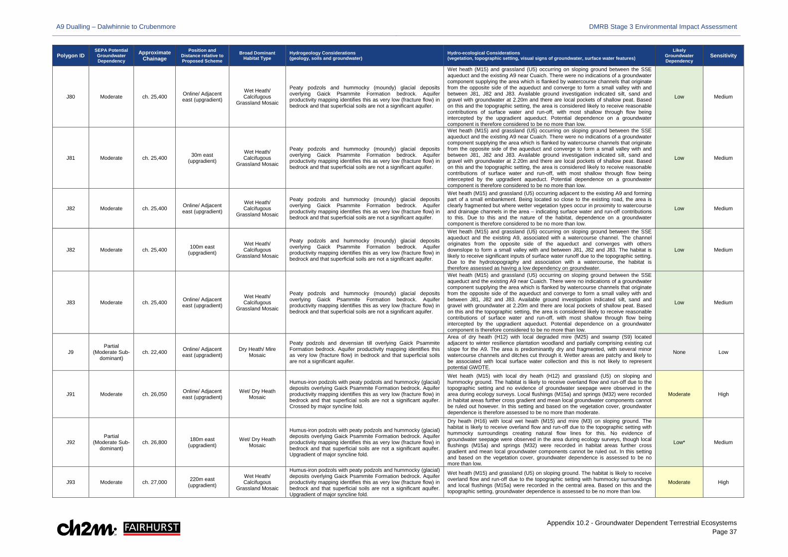
A9 Dualling – Dalwhinnie to Crubenmore DMRB Stage 3 Environmental Impact Assessment
Appendix 10.2 - Groundwater Dependent Terrestrial Ecosystems Page 37
Polygon ID SEPA Potential Groundwater Dependency
Approximate Chainage
Position and Distance relative to Proposed Scheme
Broad Dominant Habitat Type
Hydrogeology Considerations (geology, soils and groundwater)
Hydro-ecological Considerations (vegetation, topographic setting, visual signs of groundwater, surface water features)
Likely Groundwater Dependency
Sensitivity
J80 Moderate ch. 25,400 Online/ Adjacent east (upgradient)
Wet Heath/ Calcifugous
Grassland Mosaic
Peaty podzols and hummocky (moundy) glacial deposits overlying Gaick Psammite Formation bedrock. Aquifer productivity mapping identifies this as very low (fracture flow) in bedrock and that superficial soils are not a significant aquifer.
Wet heath (M15) and grassland (U5) occurring on sloping ground between the SSE aqueduct and the existing A9 near Cuaich. There were no indications of a groundwater component supplying the area which is flanked by watercourse channels that originate from the opposite side of the aqueduct and converge to form a small valley with and between J81, J82 and J83. Available ground investigation indicated silt, sand and gravel with groundwater at 2.20m and there are local pockets of shallow peat. Based on this and the topographic setting, the area is considered likely to receive reasonable contributions of surface water and run-off, with most shallow through flow being intercepted by the upgradient aqueduct. Potential dependence on a groundwater component is therefore considered to be no more than low.
Low Medium
J81 Moderate ch. 25,400 30m east (upgradient)
Wet Heath/ Calcifugous
Grassland Mosaic
Peaty podzols and hummocky (moundy) glacial deposits overlying Gaick Psammite Formation bedrock. Aquifer productivity mapping identifies this as very low (fracture flow) in bedrock and that superficial soils are not a significant aquifer.
Wet heath (M15) and grassland (U5) occurring on sloping ground between the SSE aqueduct and the existing A9 near Cuaich. There were no indications of a groundwater component supplying the area which is flanked by watercourse channels that originate from the opposite side of the aqueduct and converge to form a small valley with and between J81, J82 and J83. Available ground investigation indicated silt, sand and gravel with groundwater at 2.20m and there are local pockets of shallow peat. Based on this and the topographic setting, the area is considered likely to receive reasonable contributions of surface water and run-off, with most shallow through flow being intercepted by the upgradient aqueduct. Potential dependence on a groundwater component is therefore considered to be no more than low.
Low Medium
J82 Moderate ch. 25,400 Online/ Adjacent east (upgradient)
Wet Heath/ Calcifugous
Grassland Mosaic
Peaty podzols and hummocky (moundy) glacial deposits overlying Gaick Psammite Formation bedrock. Aquifer productivity mapping identifies this as very low (fracture flow) in bedrock and that superficial soils are not a significant aquifer.
Wet heath (M15) and grassland (U5) occurring adjacent to the existing A9 and forming part of a small embankment. Being located so close to the existing road, the area is clearly fragmented but where wetter vegetation types occur in proximity to watercourse and drainage channels in the area – indicating surface water and run-off contributions to this. Due to this and the nature of the habitat, dependence on a groundwater component is therefore considered to be no more than low.
Low Medium
J82 Moderate ch. 25,400 100m east (upgradient)
Wet Heath/ Calcifugous
Grassland Mosaic
Peaty podzols and hummocky (moundy) glacial deposits overlying Gaick Psammite Formation bedrock. Aquifer productivity mapping identifies this as very low (fracture flow) in bedrock and that superficial soils are not a significant aquifer.
Wet heath (M15) and grassland (U5) occurring on sloping ground between the SSE aqueduct and the existing A9, associated with a watercourse channel. The channel originates from the opposite side of the aqueduct and converges with others downslope to form a small valley with and between J81, J82 and J83. The habitat is likely to receive significant inputs of surface water runoff due to the topographic setting. Due to the hydrotopography and association with a watercourse, the habitat is therefore assessed as having a low dependency on groundwater.
Low Medium
J83 Moderate ch. 25,400 Online/ Adjacent east (upgradient)
Wet Heath/ Calcifugous
Grassland Mosaic
Peaty podzols and hummocky (moundy) glacial deposits overlying Gaick Psammite Formation bedrock. Aquifer productivity mapping identifies this as very low (fracture flow) in bedrock and that superficial soils are not a significant aquifer.
Wet heath (M15) and grassland (U5) occurring on sloping ground between the SSE aqueduct and the existing A9 near Cuaich. There were no indications of a groundwater component supplying the area which is flanked by watercourse channels that originate from the opposite side of the aqueduct and converge to form a small valley with and between J81, J82 and J83. Available ground investigation indicated silt, sand and gravel with groundwater at 2.20m and there are local pockets of shallow peat. Based on this and the topographic setting, the area is considered likely to receive reasonable contributions of surface water and run-off, with most shallow through flow being intercepted by the upgradient aqueduct. Potential dependence on a groundwater component is therefore considered to be no more than low.
Low Medium
J9 Partial
(Moderate Sub-dominant)
ch. 22,400 Online/ Adjacent east (upgradient)
Dry Heath/ Mire Mosaic
Peaty podzols and devensian till overlying Gaick Psammite Formation bedrock. Aquifer productivity mapping identifies this as very low (fracture flow) in bedrock and that superficial soils are not a significant aquifer.
Area of dry heath (H12) with local degraded mire (M25) and swamp (S9) located adjacent to winter resilience plantation woodland and partially comprising existing cut slope for the A9. The area is predominantly dry and fragmented, with several minor watercourse channels and ditches cut through it. Wetter areas are patchy and likely to be associated with local surface water collection and this is not likely to represent potential GWDTE.
None Low
J91 Moderate ch. 26,050 Online/ Adjacent east (upgradient)
Wet/ Dry Heath Mosaic
Humus-iron podzols with peaty podzols and hummocky (glacial) deposits overlying Gaick Psammite Formation bedrock. Aquifer productivity mapping identifies this as very low (fracture flow) in bedrock and that superficial soils are not a significant aquifer. Crossed by major syncline fold.
Wet heath (M15) with local dry heath (H12) and grassland (U5) on sloping and hummocky ground. The habitat is likely to receive overland flow and run-off due to the topographic setting and no evidence of groundwater seepage were observed in the area during ecology surveys. Local flushings (M15a) and springs (M32) were recorded in habitat areas further cross gradient and mean local groundwater components cannot be ruled out however. In this setting and based on the vegetation cover, groundwater dependence is therefore assessed to be no more than moderate.
Moderate High
J92 Partial
(Moderate Sub-dominant)
ch. 26,800 180m east (upgradient)
Wet/ Dry Heath Mosaic
Humus-iron podzols with peaty podzols and hummocky (glacial) deposits overlying Gaick Psammite Formation bedrock. Aquifer productivity mapping identifies this as very low (fracture flow) in bedrock and that superficial soils are not a significant aquifer. Upgradient of major syncline fold.
Dry heath (H16) with local wet heath (M15) and mire (M3) on sloping ground. The habitat is likely to receive overland flow and run-off due to the topographic setting with hummocky surroundings creating natural flow lines for this. No evidence of groundwater seepage were observed in the area during ecology surveys, though local flushings (M15a) and springs (M32) were recorded in habitat areas further cross gradient and mean local groundwater components cannot be ruled out. In this setting and based on the vegetation cover, groundwater dependence is assessed to be no more than low.
Low* Medium
J93 Moderate ch. 27,000 220m east (upgradient)
Wet Heath/ Calcifugous
Grassland Mosaic
Humus-iron podzols with peaty podzols and hummocky (glacial) deposits overlying Gaick Psammite Formation bedrock. Aquifer productivity mapping identifies this as very low (fracture flow) in bedrock and that superficial soils are not a significant aquifer. Upgradient of major syncline fold.
Wet heath (M15) and grassland (U5) on sloping ground. The habitat is likely to receive overland flow and run-off due to the topographic setting with hummocky surroundings and local flushings (M15a) were recorded in the central area. Based on this and the topographic setting, groundwater dependence is assessed to be no more than low.
Moderate High
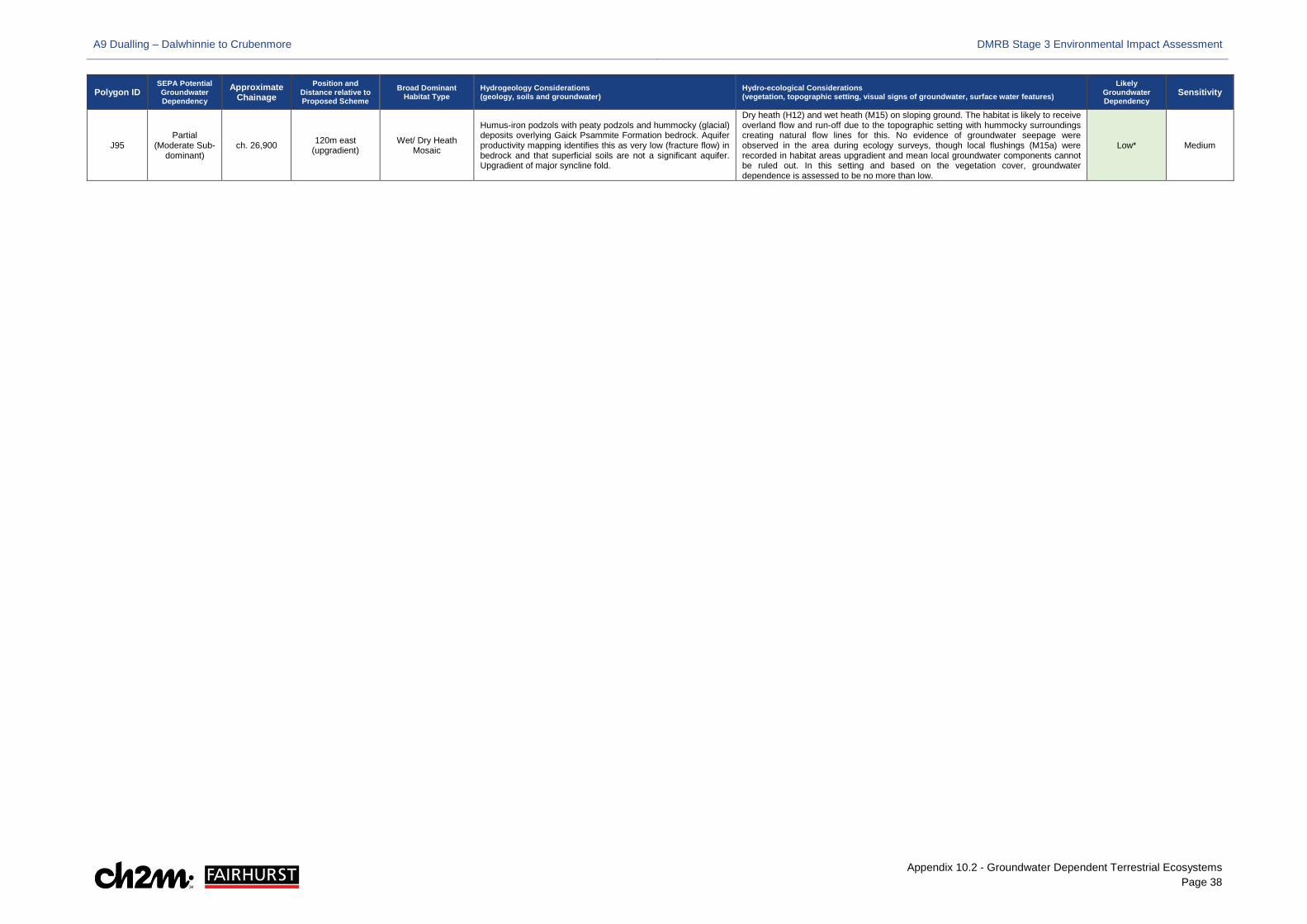
A9 Dualling – Dalwhinnie to Crubenmore DMRB Stage 3 Environmental Impact Assessment
Appendix 10.2 - Groundwater Dependent Terrestrial Ecosystems Page 38
Polygon ID SEPA Potential Groundwater Dependency
Approximate Chainage
Position and Distance relative to Proposed Scheme
Broad Dominant Habitat Type
Hydrogeology Considerations (geology, soils and groundwater)
Hydro-ecological Considerations (vegetation, topographic setting, visual signs of groundwater, surface water features)
Likely Groundwater Dependency
Sensitivity
J95 Partial
(Moderate Sub-dominant)
ch. 26,900 120m east (upgradient)
Wet/ Dry Heath Mosaic
Humus-iron podzols with peaty podzols and hummocky (glacial) deposits overlying Gaick Psammite Formation bedrock. Aquifer productivity mapping identifies this as very low (fracture flow) in bedrock and that superficial soils are not a significant aquifer. Upgradient of major syncline fold.
Dry heath (H12) and wet heath (M15) on sloping ground. The habitat is likely to receive overland flow and run-off due to the topographic setting with hummocky surroundings creating natural flow lines for this. No evidence of groundwater seepage were observed in the area during ecology surveys, though local flushings (M15a) were recorded in habitat areas upgradient and mean local groundwater components cannot be ruled out. In this setting and based on the vegetation cover, groundwater dependence is assessed to be no more than low.
Low* Medium
A9 Dualling – Dalwhinnie to Crubenmore DMRB Stage 3 Environmental Impact Assessment
Appendix 10.2 - Groundwater Dependent Terrestrial Ecosystems Page 39
3.1.24 Based on Table 4 and the review of the hydro-ecological context of each habitat; the landforms, topography and vegetation present varies throughout the study area. Combined with the hydrogeological setting, this means there is a complex range of groundwater and other water supply mechanisms present, which will significantly and locally influence the vegetation.
3.1.25 In this respect, it has been identified that groundwater is unlikely to be a contributory source to some 62 habitats, particularly those comprising existing road verge, embankment or cut slopes, and where wet vegetation comprises small fragmented and discontinuous parts within or at the margins of these, frequently associated with surface water features or run-off. A total of 79 have also been assessed as being likely to have only a low dependency on groundwater inputs due to their topographic setting, the likely influence of surface water and run-off, presence in areas of floodplain or association with ombrogenous areas of peatland.
3.1.26 The remaining areas of wet heath (NVC M15), mire (NVC M6) and grasslands (NVC U6, MG9, MG10) have been identified as dominant or sub-dominant communities in several habitat areas and considered likely to be dependent on groundwater to varying degrees. As identified in Table 4; 58 have been identified to have moderate dependence on groundwater input, 14 have been identified to have moderate/ high dependence on groundwater input, and 5 have been identified to have a high dependence on groundwater input.
3.1.27 These habitats are located throughout the Proposed Scheme, to the east and west; where either the topographic setting and presence of faulting correspond to potential or evidenced increased groundwater supply from fractured bedrock via emergence, seepage and through-flow from spring heads (NVC M32) and soligenous (NVC M15a) or base-enriched (NVC M10 and M11) flushings, or the hydrogeological conditions are such that regional groundwater through-flow within permeable and productive superficial soils are likely to support GWDTE presence.
4 Potential Impacts
Embedded Mitigation
4.1.1 Throughout the DMRB Stage 3 design development process for the Proposed Scheme; a number of environmentally-led workshops considered each aspect of the developing design and made recommendations for certain features to be included, or aspects of the design to be reconsidered. Potential GWDTE were afforded consideration throughout this process and their presence informed a number of infrastructure layout and positioning changes for particular scheme elements including the Dalwhinnie junction, SuDS basins 225, 241 (removed from the Proposed Scheme) and 254, the proposed Drumochter Estate access track and the positioning of compensatory flood storage areas, as further described in Chapter 4 (Volume 1).
4.1.2 Notwithstanding, almost all infrastructure for the Proposed Scheme is located within 100m of habitat areas with at least a degree of groundwater dependence as detailed in Table 4. Although further actions to avoid or reduce impacts may still be achievable through the use of appropriate construction materials and techniques, and further micrositing and groundwater management during detailed design or construction, several areas are likely to be unavoidable and will be disturbed directly and/ or indirectly.
Potential Impact Assessment
4.1.3 The Proposed Scheme has the potential to impact on those areas which are unavoidable during both construction and operation, through dewatering or aspects of infrastructure which may impede or alter local hydrological regimes and groundwater flows. The areas are also susceptible
A9 Dualling – Dalwhinnie to Crubenmore DMRB Stage 3 Environmental Impact Assessment
Appendix 10.2 - Groundwater Dependent Terrestrial Ecosystems Page 40
to direct loss within permanent works areas, temporary disturbance in the wider LMA and potential groundwater disruption associated with these.
4.1.4 Based on this, a semi-quantitative assessment of potential impacts has been undertaken and is summarised in Table 5. Within this, the extents of individual habitat areas affected due to the permanent or temporary works have been quantified, and consideration of indirect effects in relation to widenings or cuttings likely to intercept groundwater has been based on the semi-quantitative empirical formula of Sichardt (Powers et al., 2007; CIRIA, 2016), as applied for the groundwater level and flow assessment in Chapter 10 (Volume 1).
4.1.5 The Sichardt calculations have been based on the maximum local groundwater depth level anticipated in each widening or cutting area, as per Table 10-13 in Chapter 10 (Volume 1), and hydraulic conductivities ranging from 10-4 and 10-5 metres per second (m/s) have been applied. This was considered reasonably conservative based on the range of anticipated permeabilities and the fact that the excavations are anticipated to be predominantly formed in coarse granular till and hummocky glacial deposits to the east and west, but also alluvium and alluvial fan in southern extents towards Drumochter and in central areas near and north of Cuaich.
4.1.6 The magnitude and significance of impact for each area is based on combined consideration of the potential direct and indirect effects where relevant, together with the potential drawdown at the receptor against the intervening topography and the nature of the anticipated local water supply mechanisms from Table 4.
4.1.7 Where no impact is anticipated, or the areas have been identified to be outwith zones of dewatering influence for widenings or cuttings, magnitude and significance are either assigned as ‘N/A’ or qualitatively considered in the context of other works proposed up or downgradient. All habitats based on their likely groundwater dependence and assigned sensitivity from Table 4 have been considered. Those habitats determined to have no dependency on groundwater input are excluded, as direct impacts on these areas are considered as part of the ecological impact assessment in Chapter 12 (Volume 1) and indirect effects related to groundwater are not considered to be applicable.
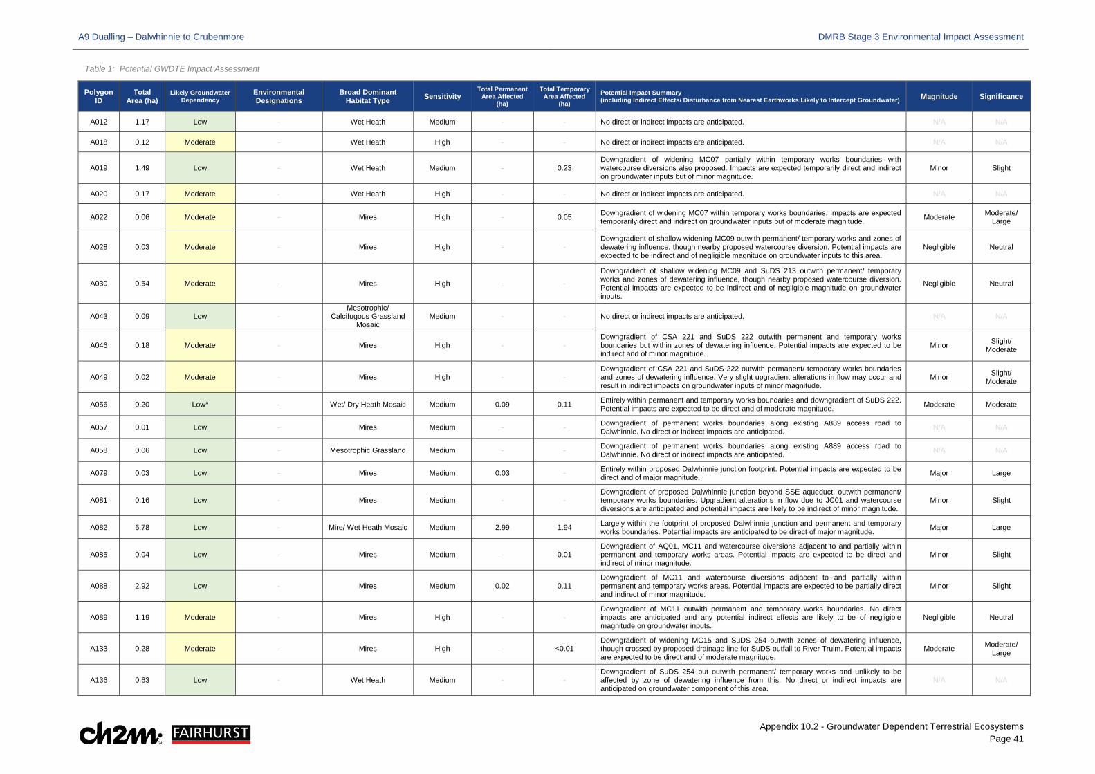
A9 Dualling – Dalwhinnie to Crubenmore DMRB Stage 3 Environmental Impact Assessment
Appendix 10.2 - Groundwater Dependent Terrestrial Ecosystems Page 41
Table 1: Potential GWDTE Impact Assessment
Polygon ID
Total Area (ha)
Likely Groundwater Dependency
Environmental Designations
Broad Dominant Habitat Type Sensitivity
Total Permanent Area Affected
(ha)
Total Temporary Area Affected
(ha) Potential Impact Summary (including Indirect Effects/ Disturbance from Nearest Earthworks Likely to Intercept Groundwater) Magnitude Significance
A012 1.17 Low - Wet Heath Medium - - No direct or indirect impacts are anticipated. N/A N/A
A018 0.12 Moderate - Wet Heath High - - No direct or indirect impacts are anticipated. N/A N/A
A019 1.49 Low - Wet Heath Medium - 0.23 Downgradient of widening MC07 partially within temporary works boundaries with watercourse diversions also proposed. Impacts are expected temporarily direct and indirect on groundwater inputs but of minor magnitude.
Minor Slight
A020 0.17 Moderate - Wet Heath High - - No direct or indirect impacts are anticipated. N/A N/A
A022 0.06 Moderate - Mires High - 0.05 Downgradient of widening MC07 within temporary works boundaries. Impacts are expected temporarily direct and indirect on groundwater inputs but of moderate magnitude. Moderate Moderate/
Large
A028 0.03 Moderate - Mires High - - Downgradient of shallow widening MC09 outwith permanent/ temporary works and zones of dewatering influence, though nearby proposed watercourse diversion. Potential impacts are expected to be indirect and of negligible magnitude on groundwater inputs to this area.
Negligible Neutral
A030 0.54 Moderate - Mires High - -
Downgradient of shallow widening MC09 and SuDS 213 outwith permanent/ temporary works and zones of dewatering influence, though nearby proposed watercourse diversion. Potential impacts are expected to be indirect and of negligible magnitude on groundwater inputs.
Negligible Neutral
A043 0.09 Low - Mesotrophic/
Calcifugous Grassland Mosaic
Medium - - No direct or indirect impacts are anticipated. N/A N/A
A046 0.18 Moderate - Mires High - - Downgradient of CSA 221 and SuDS 222 outwith permanent and temporary works boundaries but within zones of dewatering influence. Potential impacts are expected to be indirect and of minor magnitude.
Minor Slight/ Moderate
A049 0.02 Moderate - Mires High - - Downgradient of CSA 221 and SuDS 222 outwith permanent/ temporary works boundaries and zones of dewatering influence. Very slight upgradient alterations in flow may occur and result in indirect impacts on groundwater inputs of minor magnitude.
Minor Slight/ Moderate
A056 0.20 Low* - Wet/ Dry Heath Mosaic Medium 0.09 0.11 Entirely within permanent and temporary works boundaries and downgradient of SuDS 222. Potential impacts are expected to be direct and of moderate magnitude. Moderate Moderate
A057 0.01 Low - Mires Medium - - Downgradient of permanent works boundaries along existing A889 access road to Dalwhinnie. No direct or indirect impacts are anticipated. N/A N/A
A058 0.06 Low - Mesotrophic Grassland Medium - - Downgradient of permanent works boundaries along existing A889 access road to Dalwhinnie. No direct or indirect impacts are anticipated. N/A N/A
A079 0.03 Low - Mires Medium 0.03 - Entirely within proposed Dalwhinnie junction footprint. Potential impacts are expected to be direct and of major magnitude. Major Large
A081 0.16 Low - Mires Medium - - Downgradient of proposed Dalwhinnie junction beyond SSE aqueduct, outwith permanent/ temporary works boundaries. Upgradient alterations in flow due to JC01 and watercourse diversions are anticipated and potential impacts are likely to be indirect of minor magnitude.
Minor Slight
A082 6.78 Low - Mire/ Wet Heath Mosaic Medium 2.99 1.94 Largely within the footprint of proposed Dalwhinnie junction and permanent and temporary works boundaries. Potential impacts are anticipated to be direct of major magnitude. Major Large
A085 0.04 Low - Mires Medium - 0.01 Downgradient of AQ01, MC11 and watercourse diversions adjacent to and partially within permanent and temporary works areas. Potential impacts are expected to be direct and indirect of minor magnitude.
Minor Slight
A088 2.92 Low - Mires Medium 0.02 0.11 Downgradient of MC11 and watercourse diversions adjacent to and partially within permanent and temporary works areas. Potential impacts are expected to be partially direct and indirect of minor magnitude.
Minor Slight
A089 1.19 Moderate - Mires High - - Downgradient of MC11 outwith permanent and temporary works boundaries. No direct impacts are anticipated and any potential indirect effects are likely to be of negligible magnitude on groundwater inputs.
Negligible Neutral
A133 0.28 Moderate - Mires High - <0.01 Downgradient of widening MC15 and SuDS 254 outwith zones of dewatering influence, though crossed by proposed drainage line for SuDS outfall to River Truim. Potential impacts are expected to be direct and of moderate magnitude.
Moderate Moderate/ Large
A136 0.63 Low - Wet Heath Medium - - Downgradient of SuDS 254 but outwith permanent/ temporary works and unlikely to be affected by zone of dewatering influence from this. No direct or indirect impacts are anticipated on groundwater component of this area.
N/A N/A
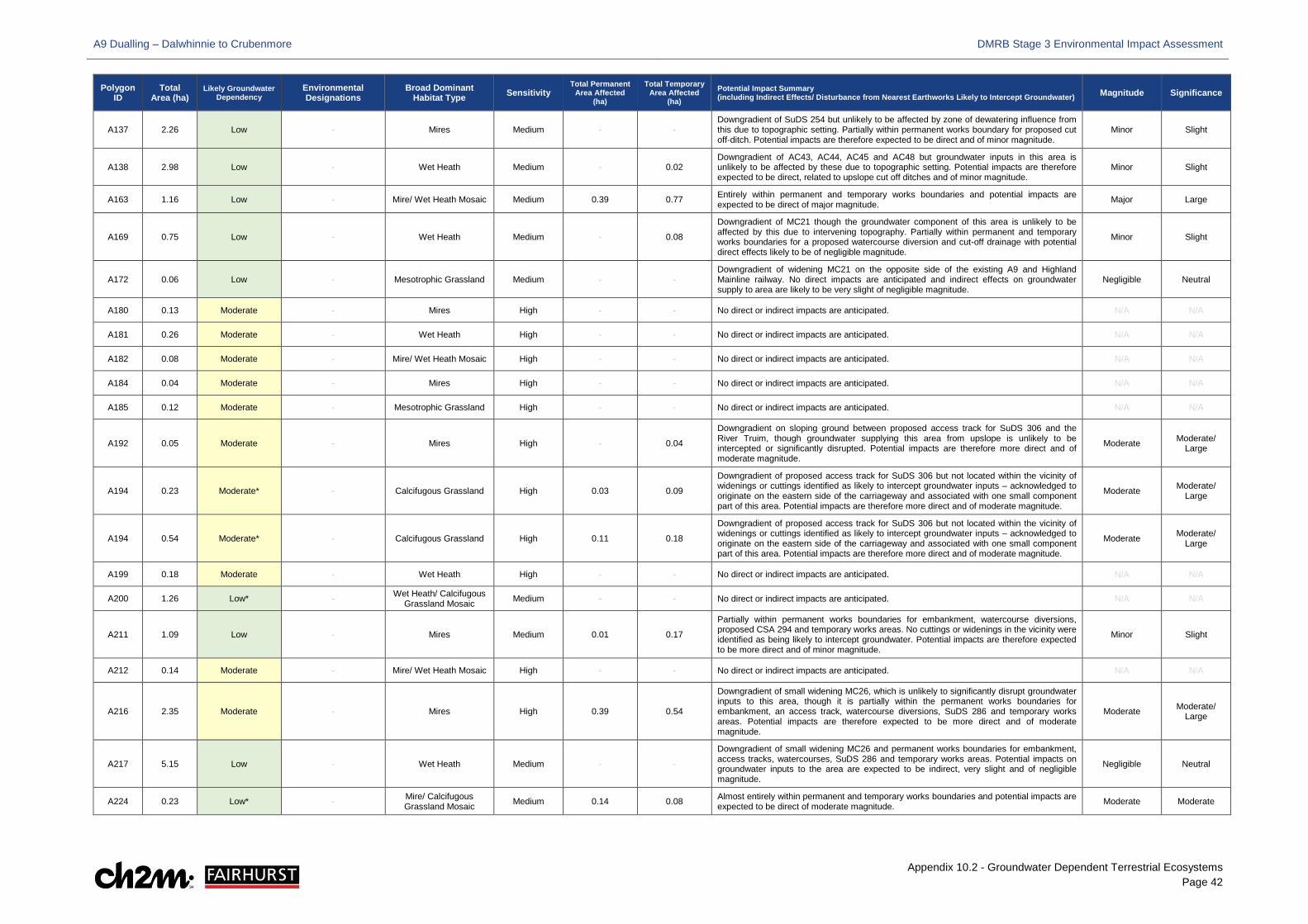
A9 Dualling – Dalwhinnie to Crubenmore DMRB Stage 3 Environmental Impact Assessment
Appendix 10.2 - Groundwater Dependent Terrestrial Ecosystems Page 42
Polygon ID
Total Area (ha)
Likely Groundwater Dependency
Environmental Designations
Broad Dominant Habitat Type Sensitivity
Total Permanent Area Affected
(ha)
Total Temporary Area Affected
(ha) Potential Impact Summary (including Indirect Effects/ Disturbance from Nearest Earthworks Likely to Intercept Groundwater) Magnitude Significance
A137 2.26 Low - Mires Medium - - Downgradient of SuDS 254 but unlikely to be affected by zone of dewatering influence from this due to topographic setting. Partially within permanent works boundary for proposed cut off-ditch. Potential impacts are therefore expected to be direct and of minor magnitude.
Minor Slight
A138 2.98 Low - Wet Heath Medium - 0.02 Downgradient of AC43, AC44, AC45 and AC48 but groundwater inputs in this area is unlikely to be affected by these due to topographic setting. Potential impacts are therefore expected to be direct, related to upslope cut off ditches and of minor magnitude.
Minor Slight
A163 1.16 Low - Mire/ Wet Heath Mosaic Medium 0.39 0.77 Entirely within permanent and temporary works boundaries and potential impacts are expected to be direct of major magnitude. Major Large
A169 0.75 Low - Wet Heath Medium - 0.08
Downgradient of MC21 though the groundwater component of this area is unlikely to be affected by this due to intervening topography. Partially within permanent and temporary works boundaries for a proposed watercourse diversion and cut-off drainage with potential direct effects likely to be of negligible magnitude.
Minor Slight
A172 0.06 Low - Mesotrophic Grassland Medium - - Downgradient of widening MC21 on the opposite side of the existing A9 and Highland Mainline railway. No direct impacts are anticipated and indirect effects on groundwater supply to area are likely to be very slight of negligible magnitude.
Negligible Neutral
A180 0.13 Moderate - Mires High - - No direct or indirect impacts are anticipated. N/A N/A
A181 0.26 Moderate - Wet Heath High - - No direct or indirect impacts are anticipated. N/A N/A
A182 0.08 Moderate - Mire/ Wet Heath Mosaic High - - No direct or indirect impacts are anticipated. N/A N/A
A184 0.04 Moderate - Mires High - - No direct or indirect impacts are anticipated. N/A N/A
A185 0.12 Moderate - Mesotrophic Grassland High - - No direct or indirect impacts are anticipated. N/A N/A
A192 0.05 Moderate - Mires High - 0.04
Downgradient on sloping ground between proposed access track for SuDS 306 and the River Truim, though groundwater supplying this area from upslope is unlikely to be intercepted or significantly disrupted. Potential impacts are therefore more direct and of moderate magnitude.
Moderate Moderate/ Large
A194 0.23 Moderate* - Calcifugous Grassland High 0.03 0.09
Downgradient of proposed access track for SuDS 306 but not located within the vicinity of widenings or cuttings identified as likely to intercept groundwater inputs – acknowledged to originate on the eastern side of the carriageway and associated with one small component part of this area. Potential impacts are therefore more direct and of moderate magnitude.
Moderate Moderate/ Large
A194 0.54 Moderate* - Calcifugous Grassland High 0.11 0.18
Downgradient of proposed access track for SuDS 306 but not located within the vicinity of widenings or cuttings identified as likely to intercept groundwater inputs – acknowledged to originate on the eastern side of the carriageway and associated with one small component part of this area. Potential impacts are therefore more direct and of moderate magnitude.
Moderate Moderate/ Large
A199 0.18 Moderate - Wet Heath High - - No direct or indirect impacts are anticipated. N/A N/A
A200 1.26 Low* - Wet Heath/ Calcifugous Grassland Mosaic Medium - - No direct or indirect impacts are anticipated. N/A N/A
A211 1.09 Low - Mires Medium 0.01 0.17
Partially within permanent works boundaries for embankment, watercourse diversions, proposed CSA 294 and temporary works areas. No cuttings or widenings in the vicinity were identified as being likely to intercept groundwater. Potential impacts are therefore expected to be more direct and of minor magnitude.
Minor Slight
A212 0.14 Moderate - Mire/ Wet Heath Mosaic High - - No direct or indirect impacts are anticipated. N/A N/A
A216 2.35 Moderate - Mires High 0.39 0.54
Downgradient of small widening MC26, which is unlikely to significantly disrupt groundwater inputs to this area, though it is partially within the permanent works boundaries for embankment, an access track, watercourse diversions, SuDS 286 and temporary works areas. Potential impacts are therefore expected to be more direct and of moderate magnitude.
Moderate Moderate/ Large
A217 5.15 Low - Wet Heath Medium - -
Downgradient of small widening MC26 and permanent works boundaries for embankment, access tracks, watercourses, SuDS 286 and temporary works areas. Potential impacts on groundwater inputs to the area are expected to be indirect, very slight and of negligible magnitude.
Negligible Neutral
A224 0.23 Low* - Mire/ Calcifugous Grassland Mosaic Medium 0.14 0.08 Almost entirely within permanent and temporary works boundaries and potential impacts are
expected to be direct of moderate magnitude. Moderate Moderate
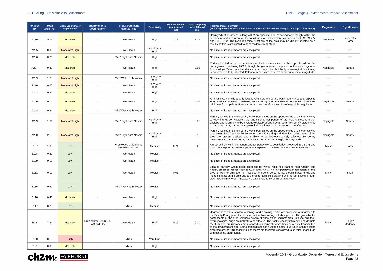
A9 Dualling – Dalwhinnie to Crubenmore DMRB Stage 3 Environmental Impact Assessment
Appendix 10.2 - Groundwater Dependent Terrestrial Ecosystems Page 43
Polygon ID
Total Area (ha)
Likely Groundwater Dependency
Environmental Designations
Broad Dominant Habitat Type Sensitivity
Total Permanent Area Affected
(ha)
Total Temporary Area Affected
(ha) Potential Impact Summary (including Indirect Effects/ Disturbance from Nearest Earthworks Likely to Intercept Groundwater) Magnitude Significance
A226 5.28 Moderate - Wet Heath High 1.11 1.18
Downgradient of access cutting AC62 on opposite side of carriageway though within the permanent and temporary works boundaries for embankment, an access track, SuDS 277 and SuDS 282. The hydrogeological functions of the area may be directly affected as a result and this is anticipated to be of moderate magnitude.
Moderate Moderate/ Large
A235 0.06 Moderate/ High - Wet Heath High/ Very High - - No direct or indirect impacts are anticipated. N/A N/A
A236 0.26 Moderate - Wet/ Dry Heath Mosaic High - - No direct or indirect impacts are anticipated. N/A N/A
A237 0.32 Moderate - Wet Heath High - 0.02
Partially located within the temporary works boundaries and on the opposite side of the carriageway to widening MC29, though the groundwater component of the area originates from upslope. Temporary disturbance to part may occur, but the hydrogeological functioning is not expected to be affected. Potential impacts are therefore direct but of minor magnitude.
Negligible Neutral
A239 1.23 Moderate/ High - Mire/ Wet Heath Mosaic High/ Very High - - No direct or indirect impacts are anticipated. N/A N/A
A240 0.80 Moderate/ High - Wet Heath High/ Very High - - No direct or indirect impacts are anticipated. N/A N/A
A242 0.32 Moderate - Wet Heath High - - No direct or indirect impacts are anticipated. N/A N/A
A246 0.76 Moderate - Wet Heath High - 0.01 A minor extent of this area is located within the temporary works boundaries and opposite side of the carriageway to widening MC29, though the groundwater component of the area originates from upslope. Potential impacts are therefore direct but of negligible magnitude.
Negligible Neutral
A248 0.24 Moderate - Mire/ Wet Heath Mosaic High - - No direct or indirect impacts are anticipated. N/A N/A
A259 1.61 Moderate/ High - Wet/ Dry Heath Mosaic High/ Very High - 0.06
Partially located in the temporary works boundaries on the opposite side of the carriageway to widening MC29. However, the M32a spring component of the area is present further upslope and is unlikely to be hydrogeologically affected as a result. Temporary disturbance to part may occur, but the hydrogeological functioning is not expected to be affected.
Negligible Neutral
A260 2.10 Moderate/ High - Wet/ Dry Heath Mosaic High/ Very High - 0.16
Partially located in the temporary works boundaries on the opposite side of the carriageway to widening MC27 and MC29. However, the M32a spring and M10 flush components of the area are present upslope and unlikely to be hydrogeologically affected. Temporary disturbance to part may occur, but this is expected to be of negligible magnitude.
Negligible Neutral
B107 1.39 Low - Wet Heath/ Calcifugous Grassland Mosaic Medium 0.71 0.25 Almost entirely within permanent and temporary works boundaries, proposed SuDS 258 and
CSA 259 footprint. Potential impacts are expected to be direct and of major magnitude. Major Large
B108 0.29 Low - Wet Heath Medium - - No direct or indirect impacts are anticipated. N/A N/A
B109 0.10 Low - Wet Heath Medium - - No direct or indirect impacts are anticipated. N/A N/A
B111 0.12 Low - Wet Heath Medium 0.01 -
Located partially within areas proposed for winter resilience planting near Cuaich and nearby proposed access cuttings AC44 and AC45. The low groundwater component of this area is likely to originate from upslope and continue to do so, though partial direct and indirect impact on the area due to the winter resilience planting and indirect effects through water uptake may occur. Impacts are anticipated to be of minor magnitude.
Minor Slight
B115 0.67 Low - Mire/ Wet Heath Mosaic Medium - - No direct or indirect impacts are anticipated. N/A N/A
B116 0.40 Moderate - Wet Heath High - - No direct or indirect impacts are anticipated. N/A N/A
B117 0.25 Low - Mires Medium - - No direct or indirect impacts are anticipated. N/A N/A
B12 7.24 Moderate Drumochter Hills SSSI, SAC and SPA Wet Heath High 0.16 0.30
Upgradient of where shallow widenings and a drainage ditch are proposed for upgrades to the Beauly-Denny powerline access track within existing disturbed ground. The groundwater components of the area comprise several flushes which originate from upslope and their hydrogeological origin are unlikely to be affected. The track presently intercepts and disrupts the flush flow, but upgrades are proposed to incorporate cross-track culverts to transmit this to the downgradient side. Some partial direct loss habitat is noted, but this is within existing disturbed ground. Direct and indirect effects are therefore considered to be minor magnitude with beneficial significance.
Minor Slight/ Moderate
B120 0.19 High - Mires Very High - - No direct or indirect impacts are anticipated. N/A N/A
B121 0.05 Moderate - Mires High - - No direct or indirect impacts are anticipated. N/A N/A
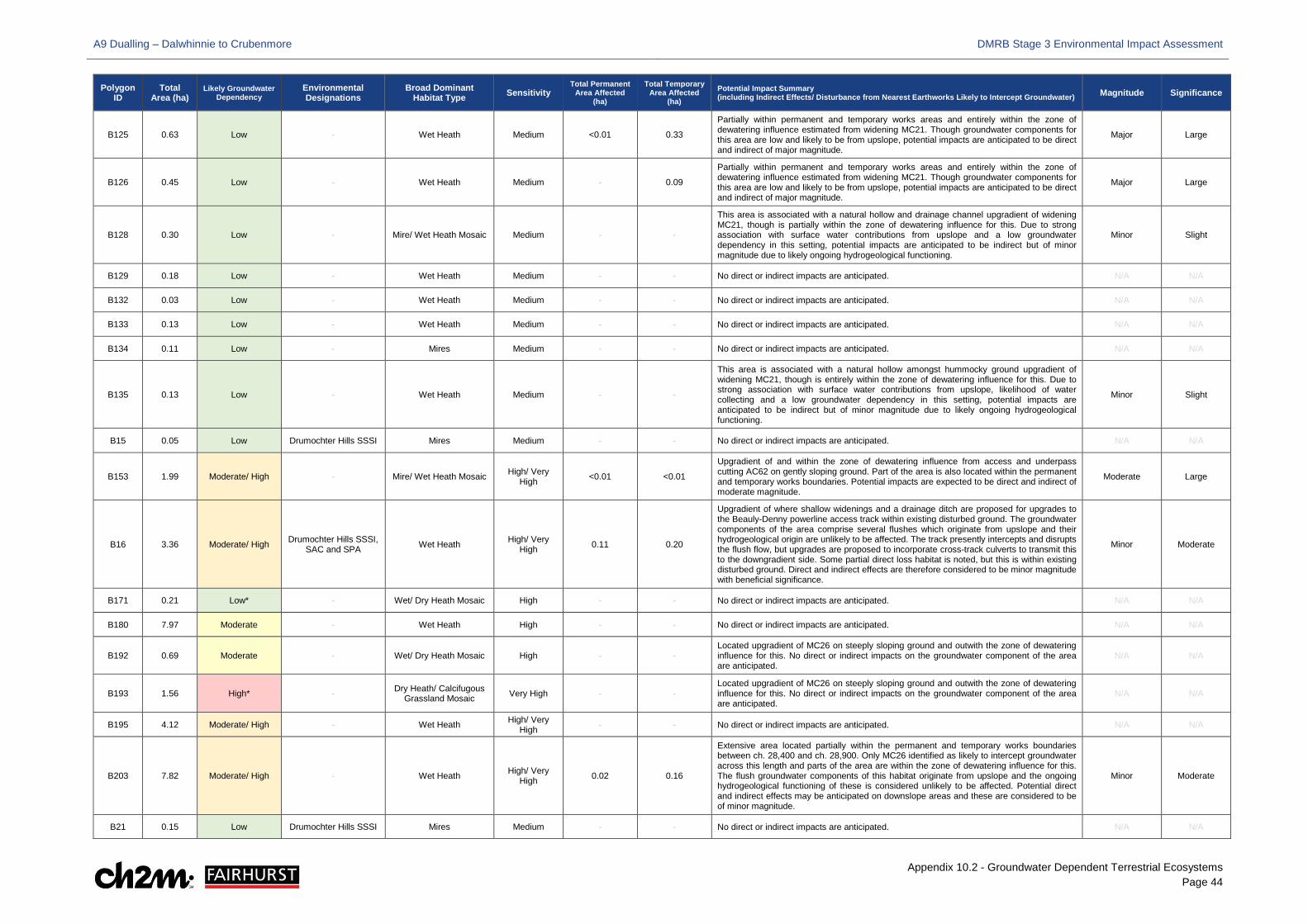
A9 Dualling – Dalwhinnie to Crubenmore DMRB Stage 3 Environmental Impact Assessment
Appendix 10.2 - Groundwater Dependent Terrestrial Ecosystems Page 44
Polygon ID
Total Area (ha)
Likely Groundwater Dependency
Environmental Designations
Broad Dominant Habitat Type Sensitivity
Total Permanent Area Affected
(ha)
Total Temporary Area Affected
(ha) Potential Impact Summary (including Indirect Effects/ Disturbance from Nearest Earthworks Likely to Intercept Groundwater) Magnitude Significance
B125 0.63 Low - Wet Heath Medium <0.01 0.33
Partially within permanent and temporary works areas and entirely within the zone of dewatering influence estimated from widening MC21. Though groundwater components for this area are low and likely to be from upslope, potential impacts are anticipated to be direct and indirect of major magnitude.
Major Large
B126 0.45 Low - Wet Heath Medium - 0.09
Partially within permanent and temporary works areas and entirely within the zone of dewatering influence estimated from widening MC21. Though groundwater components for this area are low and likely to be from upslope, potential impacts are anticipated to be direct and indirect of major magnitude.
Major Large
B128 0.30 Low - Mire/ Wet Heath Mosaic Medium - -
This area is associated with a natural hollow and drainage channel upgradient of widening MC21, though is partially within the zone of dewatering influence for this. Due to strong association with surface water contributions from upslope and a low groundwater dependency in this setting, potential impacts are anticipated to be indirect but of minor magnitude due to likely ongoing hydrogeological functioning.
Minor Slight
B129 0.18 Low - Wet Heath Medium - - No direct or indirect impacts are anticipated. N/A N/A
B132 0.03 Low - Wet Heath Medium - - No direct or indirect impacts are anticipated. N/A N/A
B133 0.13 Low - Wet Heath Medium - - No direct or indirect impacts are anticipated. N/A N/A
B134 0.11 Low - Mires Medium - - No direct or indirect impacts are anticipated. N/A N/A
B135 0.13 Low - Wet Heath Medium - -
This area is associated with a natural hollow amongst hummocky ground upgradient of widening MC21, though is entirely within the zone of dewatering influence for this. Due to strong association with surface water contributions from upslope, likelihood of water collecting and a low groundwater dependency in this setting, potential impacts are anticipated to be indirect but of minor magnitude due to likely ongoing hydrogeological functioning.
Minor Slight
B15 0.05 Low Drumochter Hills SSSI Mires Medium - - No direct or indirect impacts are anticipated. N/A N/A
B153 1.99 Moderate/ High - Mire/ Wet Heath Mosaic High/ Very High <0.01 <0.01
Upgradient of and within the zone of dewatering influence from access and underpass cutting AC62 on gently sloping ground. Part of the area is also located within the permanent and temporary works boundaries. Potential impacts are expected to be direct and indirect of moderate magnitude.
Moderate Large
B16 3.36 Moderate/ High Drumochter Hills SSSI, SAC and SPA Wet Heath High/ Very
High 0.11 0.20
Upgradient of where shallow widenings and a drainage ditch are proposed for upgrades to the Beauly-Denny powerline access track within existing disturbed ground. The groundwater components of the area comprise several flushes which originate from upslope and their hydrogeological origin are unlikely to be affected. The track presently intercepts and disrupts the flush flow, but upgrades are proposed to incorporate cross-track culverts to transmit this to the downgradient side. Some partial direct loss habitat is noted, but this is within existing disturbed ground. Direct and indirect effects are therefore considered to be minor magnitude with beneficial significance.
Minor Moderate
B171 0.21 Low* - Wet/ Dry Heath Mosaic High - - No direct or indirect impacts are anticipated. N/A N/A
B180 7.97 Moderate - Wet Heath High - - No direct or indirect impacts are anticipated. N/A N/A
B192 0.69 Moderate - Wet/ Dry Heath Mosaic High - - Located upgradient of MC26 on steeply sloping ground and outwith the zone of dewatering influence for this. No direct or indirect impacts on the groundwater component of the area are anticipated.
N/A N/A
B193 1.56 High* - Dry Heath/ Calcifugous Grassland Mosaic Very High - -
Located upgradient of MC26 on steeply sloping ground and outwith the zone of dewatering influence for this. No direct or indirect impacts on the groundwater component of the area are anticipated.
N/A N/A
B195 4.12 Moderate/ High - Wet Heath High/ Very High - - No direct or indirect impacts are anticipated. N/A N/A
B203 7.82 Moderate/ High - Wet Heath High/ Very High 0.02 0.16
Extensive area located partially within the permanent and temporary works boundaries between ch. 28,400 and ch. 28,900. Only MC26 identified as likely to intercept groundwater across this length and parts of the area are within the zone of dewatering influence for this. The flush groundwater components of this habitat originate from upslope and the ongoing hydrogeological functioning of these is considered unlikely to be affected. Potential direct and indirect effects may be anticipated on downslope areas and these are considered to be of minor magnitude.
Minor Moderate
B21 0.15 Low Drumochter Hills SSSI Mires Medium - - No direct or indirect impacts are anticipated. N/A N/A
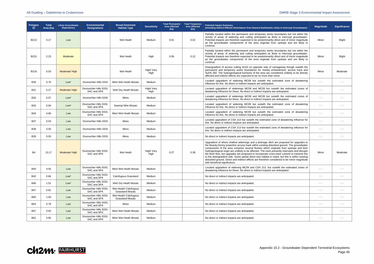
A9 Dualling – Dalwhinnie to Crubenmore DMRB Stage 3 Environmental Impact Assessment
Appendix 10.2 - Groundwater Dependent Terrestrial Ecosystems Page 45
Polygon ID
Total Area (ha)
Likely Groundwater Dependency
Environmental Designations
Broad Dominant Habitat Type Sensitivity
Total Permanent Area Affected
(ha)
Total Temporary Area Affected
(ha) Potential Impact Summary (including Indirect Effects/ Disturbance from Nearest Earthworks Likely to Intercept Groundwater) Magnitude Significance
B213 0.17 Low - Wet Heath Medium 0.01 0.02
Partially located within the permanent and temporary works boundaries but not within the vicinity of areas of widening and cutting anticipated as likely to intercept groundwater. Potential impacts are therefore expected to be predominantly direct and of minor magnitude as the groundwater components of the area originate from upslope and are likely to continue.
Minor Slight
B215 2.23 Moderate - Wet Heath High 0.06 0.12
Partially located within the permanent and temporary works boundaries but not within the vicinity of areas of widening and cutting anticipated as likely to intercept groundwater. Potential impacts are therefore expected to be predominantly direct and of minor magnitude as the groundwater components of the area originate from upslope and are likely to continue.
Minor Slight
B219 0.03 Moderate/ High - Wet Heath High/ Very High - -
Downgradient of access cutting AC62 on opposite side of carriageway though outwith the permanent and temporary works boundaries for nearby embankment, access track and SuDS 282. The hydrogeological functions of the area are considered unlikely to be directly affected and indirect effects are expected to be no more than minor
Minor Moderate
B30 0.76 Low* Drumochter Hills SSSI Mire/ Wet Heath Mosaic Medium - - Located upgradient of widening MC08 but outwith the estimated zone of dewatering influence for this. No direct or indirect impacts are anticipated. N/A N/A
B31 5.27 Moderate/ High Drumochter Hills SSSI, SAC and SPA Wet/ Dry Heath Mosaic High/ Very
High - - Located upgradient of widenings MC08 and MC09 but outwith the estimated zones of dewatering influence for these. No direct or indirect impacts are anticipated. N/A N/A
B32 0.07 Low* Drumochter Hills SSSI Mires Medium - - Located upgradient of widenings MC08 and MC09 but outwith the estimated zones of dewatering influence for these. No direct or indirect impacts are anticipated. N/A N/A
B33 0.94 Low* Drumochter Hills SSSI, SAC and SPA Swamp/ Mire Mosaic Medium - - Located upgradient of widening MC09 but outwith the estimated zone of dewatering
influence for this. No direct or indirect impacts are anticipated. N/A N/A
B34 4.66 Low Drumochter Hills SSSI, SAC and SPA Mire/ Wet Heath Mosaic Medium - - Located upgradient of widening MC09 but outwith the estimated zone of dewatering
influence for this. No direct or indirect impacts are anticipated. N/A N/A
B37 0.03 Low Drumochter Hills SSSI Mires Medium - - Located upgradient of CSA 213 but outwith the estimated zone of dewatering influence for this. No direct or indirect impacts are anticipated. N/A N/A
B38 0.05 Low Drumochter Hills SSSI Mires Medium - - Located upgradient of CSA 213 but outwith the estimated zone of dewatering influence for this. No direct or indirect impacts are anticipated. N/A N/A
B39 0.05 Low Drumochter Hills SSSI Mires Medium - - No direct or indirect impacts are anticipated. N/A N/A
B4 13.17 Moderate/ High Drumochter Hills SSSI, SAC and SPA Wet Heath High/ Very
High 0.27 0.38
Upgradient of where shallow widenings and a drainage ditch are proposed for upgrades to the Beauly-Denny powerline access track within existing disturbed ground. The groundwater components of the area comprise several flushes which originate from upslope and their hydrogeological origin are unlikely to be affected. The track presently intercepts and disrupts the flush flow, but upgrades are proposed to incorporate cross-track culverts to transmit this to the downgradient side. Some partial direct loss habitat is noted, but this is within existing disturbed ground. Direct and indirect effects are therefore considered to be minor magnitude with beneficial significance.
Minor Moderate
B40 4.55 Low Drumochter Hills SSSI, SAC and SPA Mire/ Wet Heath Mosaic Medium - - Located upgradient of widening MC09 and CSA 213, but outwith the estimated zones of
dewatering influence for these. No direct or indirect impacts are anticipated. N/A N/A
B42 0.66 Low* Drumochter Hills SSSI, SAC and SPA Calcifugous Grassland Medium - - No direct or indirect impacts are anticipated. N/A N/A
B46 1.51 Low* Drumochter Hills SSSI, SAC and SPA Wet/ Dry Heath Mosaic Medium - - No direct or indirect impacts are anticipated. N/A N/A
B47 0.81 Low Drumochter Hills SSSI, SAC and SPA
Wet Heath/ Calcifugous Grassland Mosaic Medium - - No direct or indirect impacts are anticipated. N/A N/A
B50 1.56 Low Drumochter Hills SSSI, SAC and SPA
Wet Heath/ Calcifugous Grassland Mosaic Medium - - No direct or indirect impacts are anticipated. N/A N/A
B54 0.78 Low Drumochter Hills SSSI, SAC and SPA Mires Medium - - No direct or indirect impacts are anticipated. N/A N/A
B57 0.92 Low Drumochter Hills SSSI, SAC and SPA Mire/ Wet Heath Mosaic Medium - - No direct or indirect impacts are anticipated. N/A N/A
B61 0.85 Low Drumochter Hills SSSI, SAC and SPA Mire/ Wet Heath Mosaic Medium - - No direct or indirect impacts are anticipated. N/A N/A
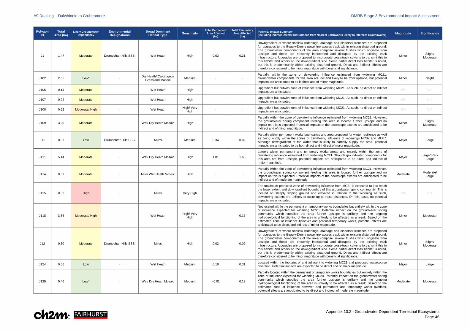
A9 Dualling – Dalwhinnie to Crubenmore DMRB Stage 3 Environmental Impact Assessment
Appendix 10.2 - Groundwater Dependent Terrestrial Ecosystems Page 46
Polygon ID
Total Area (ha)
Likely Groundwater Dependency
Environmental Designations
Broad Dominant Habitat Type Sensitivity
Total Permanent Area Affected
(ha)
Total Temporary Area Affected
(ha) Potential Impact Summary (including Indirect Effects/ Disturbance from Nearest Earthworks Likely to Intercept Groundwater) Magnitude Significance
J1 1.47 Moderate Drumochter Hills SSSI Wet Heath High 0.02 0.31
Downgradient of where shallow widenings, drainage and dispersal trenches are proposed for upgrades to the Beauly-Denny powerline access track within existing disturbed ground. The groundwater components of the area comprise several flushes which originate from upslope and these are presently intercepted and disrupted by the existing track infrastructure. Upgrades are proposed to incorporate cross-track culverts to transmit this to this habitat and others on the downgradient side. Some partial direct loss habitat is noted, but this is predominantly within existing disturbed ground. Direct and indirect effects are therefore considered to be minor magnitude with beneficial significance.
Minor Slight/ Moderate
J102 2.05 Low* - Dry Heath/ Calcifugous Grassland Mosaic Medium - -
Partially within the zone of dewatering influence estimated from widening MC21. Groundwater components for this area are low and likely to be from upslope, but potential impacts are anticipated to be indirect and of minor magnitude.
Minor Slight
J105 0.14 Moderate - Wet Heath High - - Upgradient but outwith zone of influence from widening MC21. As such, no direct or indirect impacts are anticipated. N/A N/A
J107 0.22 Moderate - Wet Heath High - - Upgradient but outwith zone of influence from widening MC21. As such, no direct or indirect impacts are anticipated. N/A N/A
J108 0.62 Moderate/ High - Wet Heath High/ Very High - - Upgradient but outwith zone of influence from widening MC21. As such, no direct or indirect
impacts are anticipated. N/A N/A
J109 3.20 Moderate - Wet/ Dry Heath Mosaic High - -
Partially within the zone of dewatering influence estimated from widening MC21. However, the groundwater spring component feeding this area is located further upslope and no impact on this is expected. Potential impacts at the downslope extents are anticipated to be indirect and of minor magnitude.
Minor Slight/ Moderate
J11 0.87 Low Drumochter Hills SSSI Mires Medium 0.34 0.02
Partially within permanent works boundaries and area proposed for winter resilience as well as being wholly within the zones of dewatering influence of widenings MC02 and MC07. Although downgradient of the water that is likely to partially supply the area, potential impacts are anticipated to be both direct and indirect of major magnitude.
Major Large
J111 5.14 Moderate - Wet/ Dry Heath Mosaic High 1.81 1.66
Largely within permanent and temporary works areas and entirely within the zone of dewatering influence estimated from widening MC21. Though groundwater components for this area are from upslope, potential impacts are anticipated to be direct and indirect of major magnitude.
Major Large/ Very Large
J114 0.62 Moderate - Mire/ Wet Heath Mosaic High - -
Partially within the zone of dewatering influence estimated from widening MC21. However, the groundwater spring component feeding this area is located further upslope and no impact on this is expected. Potential impacts at the downslope extents are anticipated to be indirect and of moderate magnitude.
Moderate Moderate/ Large
J115 0.02 High - Mires Very High - -
The maximum predicted zone of dewatering influence from MC21 is expected to just reach the lower extent and downgradient boundary of this groundwater spring community. This is located on steeply sloping ground and elevated in relation to the widening as such, dewatering extents are unlikely to occur up to these distances. On this basis, no potential impacts are anticipated.
N/A N/A
J118 3.35 Moderate/ High - Wet Heath High/ Very High - 0.17
Not located within the permanent or temporary works boundaries but entirely within the zone of influence expected for widening MC28. Potential impact on the groundwater spring community which supplies the area further upslope is unlikely and the ongoing hydrogeological functioning of the area is unlikely to be affected as a result. Based on the estimated zone of influence however and potential temporary works, potential effects are anticipated to be direct and indirect of minor magnitude.
Minor Moderate
J12 0.80 Moderate Drumochter Hills SSSI Mires High 0.02 0.09
Downgradient of where shallow widenings, drainage and dispersal trenches are proposed for upgrades to the Beauly-Denny powerline access track within existing disturbed ground. The groundwater components of the area comprise several flushes which originate from upslope and these are presently intercepted and disrupted by the existing track infrastructure. Upgrades are proposed to incorporate cross-track culverts to transmit this to this habitat and others on the downgradient side. Some partial direct loss habitat is noted, but this is predominantly within existing disturbed ground. Direct and indirect effects are therefore considered to be minor magnitude with beneficial significance.
Minor Slight/ Moderate
J124 0.56 Low - Wet Heath Medium 0.18 0.31 Located within the footprint of and adjacent to widening MC21 and proposed watercourse diversion. Potential impacts are expected to be direct and of major magnitude. Major Large
J125 0.46 Low* - Wet/ Dry Heath Mosaic Medium <0.01 0.13
Partially located within the permanent or temporary works boundaries but entirely within the zone of influence expected for widening MC28. Potential impact on the groundwater spring community which supplies the area further upslope is unlikely and the ongoing hydrogeological functioning of the area is unlikely to be affected as a result. Based on the estimated zone of influence however and permanent and temporary works overlaps, potential effects are anticipated to be direct and indirect of moderate magnitude.
Moderate Moderate
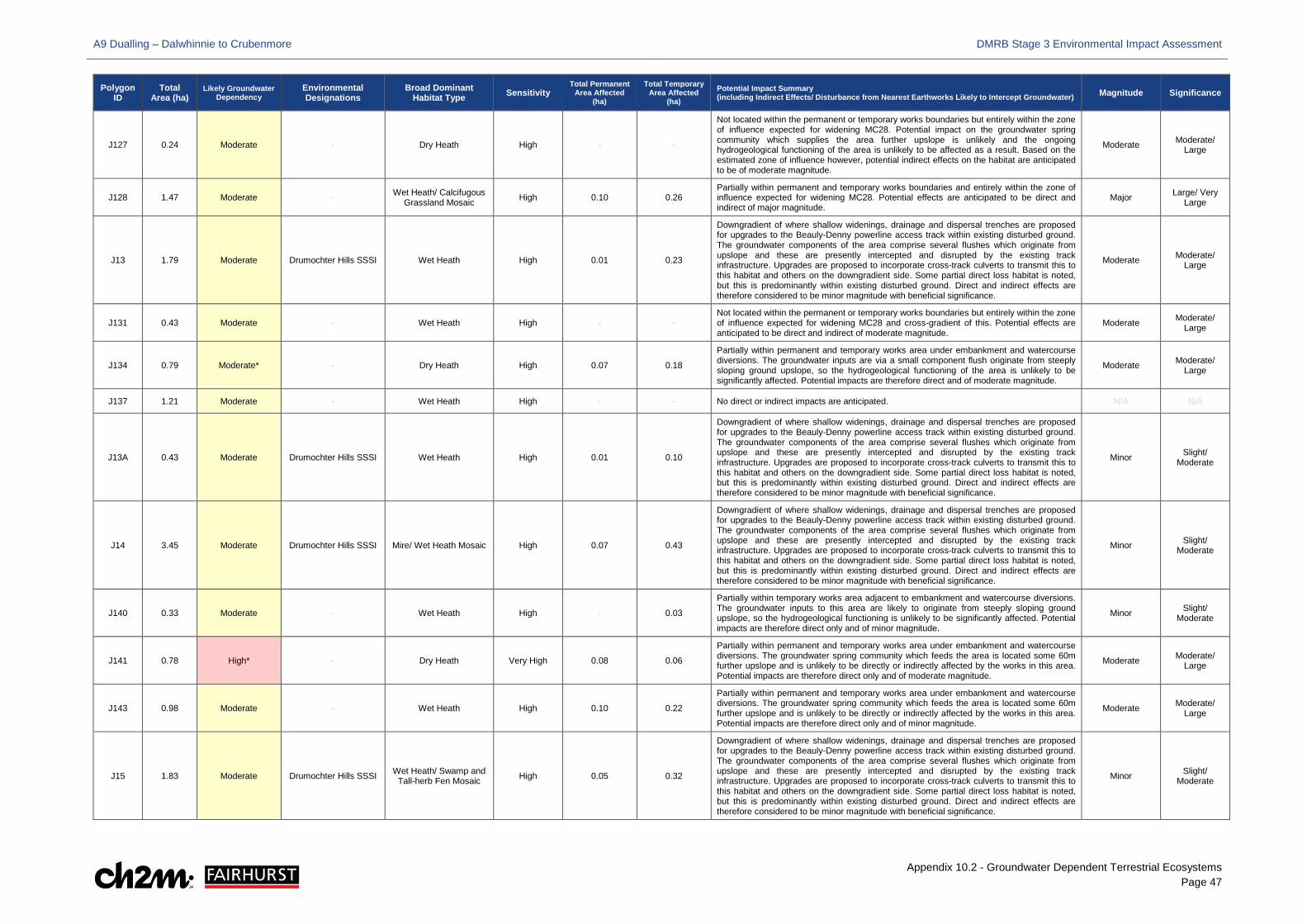
A9 Dualling – Dalwhinnie to Crubenmore DMRB Stage 3 Environmental Impact Assessment
Appendix 10.2 - Groundwater Dependent Terrestrial Ecosystems Page 47
Polygon ID
Total Area (ha)
Likely Groundwater Dependency
Environmental Designations
Broad Dominant Habitat Type Sensitivity
Total Permanent Area Affected
(ha)
Total Temporary Area Affected
(ha) Potential Impact Summary (including Indirect Effects/ Disturbance from Nearest Earthworks Likely to Intercept Groundwater) Magnitude Significance
J127 0.24 Moderate - Dry Heath High - -
Not located within the permanent or temporary works boundaries but entirely within the zone of influence expected for widening MC28. Potential impact on the groundwater spring community which supplies the area further upslope is unlikely and the ongoing hydrogeological functioning of the area is unlikely to be affected as a result. Based on the estimated zone of influence however, potential indirect effects on the habitat are anticipated to be of moderate magnitude.
Moderate Moderate/ Large
J128 1.47 Moderate - Wet Heath/ Calcifugous Grassland Mosaic High 0.10 0.26
Partially within permanent and temporary works boundaries and entirely within the zone of influence expected for widening MC28. Potential effects are anticipated to be direct and indirect of major magnitude.
Major Large/ Very Large
J13 1.79 Moderate Drumochter Hills SSSI Wet Heath High 0.01 0.23
Downgradient of where shallow widenings, drainage and dispersal trenches are proposed for upgrades to the Beauly-Denny powerline access track within existing disturbed ground. The groundwater components of the area comprise several flushes which originate from upslope and these are presently intercepted and disrupted by the existing track infrastructure. Upgrades are proposed to incorporate cross-track culverts to transmit this to this habitat and others on the downgradient side. Some partial direct loss habitat is noted, but this is predominantly within existing disturbed ground. Direct and indirect effects are therefore considered to be minor magnitude with beneficial significance.
Moderate Moderate/ Large
J131 0.43 Moderate - Wet Heath High - - Not located within the permanent or temporary works boundaries but entirely within the zone of influence expected for widening MC28 and cross-gradient of this. Potential effects are anticipated to be direct and indirect of moderate magnitude.
Moderate Moderate/ Large
J134 0.79 Moderate* - Dry Heath High 0.07 0.18
Partially within permanent and temporary works area under embankment and watercourse diversions. The groundwater inputs are via a small component flush originate from steeply sloping ground upslope, so the hydrogeological functioning of the area is unlikely to be significantly affected. Potential impacts are therefore direct and of moderate magnitude.
Moderate Moderate/ Large
J137 1.21 Moderate - Wet Heath High - - No direct or indirect impacts are anticipated. N/A N/A
J13A 0.43 Moderate Drumochter Hills SSSI Wet Heath High 0.01 0.10
Downgradient of where shallow widenings, drainage and dispersal trenches are proposed for upgrades to the Beauly-Denny powerline access track within existing disturbed ground. The groundwater components of the area comprise several flushes which originate from upslope and these are presently intercepted and disrupted by the existing track infrastructure. Upgrades are proposed to incorporate cross-track culverts to transmit this to this habitat and others on the downgradient side. Some partial direct loss habitat is noted, but this is predominantly within existing disturbed ground. Direct and indirect effects are therefore considered to be minor magnitude with beneficial significance.
Minor Slight/ Moderate
J14 3.45 Moderate Drumochter Hills SSSI Mire/ Wet Heath Mosaic High 0.07 0.43
Downgradient of where shallow widenings, drainage and dispersal trenches are proposed for upgrades to the Beauly-Denny powerline access track within existing disturbed ground. The groundwater components of the area comprise several flushes which originate from upslope and these are presently intercepted and disrupted by the existing track infrastructure. Upgrades are proposed to incorporate cross-track culverts to transmit this to this habitat and others on the downgradient side. Some partial direct loss habitat is noted, but this is predominantly within existing disturbed ground. Direct and indirect effects are therefore considered to be minor magnitude with beneficial significance.
Minor Slight/ Moderate
J140 0.33 Moderate - Wet Heath High - 0.03
Partially within temporary works area adjacent to embankment and watercourse diversions. The groundwater inputs to this area are likely to originate from steeply sloping ground upslope, so the hydrogeological functioning is unlikely to be significantly affected. Potential impacts are therefore direct only and of minor magnitude.
Minor Slight/ Moderate
J141 0.78 High* - Dry Heath Very High 0.08 0.06
Partially within permanent and temporary works area under embankment and watercourse diversions. The groundwater spring community which feeds the area is located some 60m further upslope and is unlikely to be directly or indirectly affected by the works in this area. Potential impacts are therefore direct only and of moderate magnitude.
Moderate Moderate/ Large
J143 0.98 Moderate - Wet Heath High 0.10 0.22
Partially within permanent and temporary works area under embankment and watercourse diversions. The groundwater spring community which feeds the area is located some 60m further upslope and is unlikely to be directly or indirectly affected by the works in this area. Potential impacts are therefore direct only and of minor magnitude.
Moderate Moderate/ Large
J15 1.83 Moderate Drumochter Hills SSSI Wet Heath/ Swamp and Tall-herb Fen Mosaic High 0.05 0.32
Downgradient of where shallow widenings, drainage and dispersal trenches are proposed for upgrades to the Beauly-Denny powerline access track within existing disturbed ground. The groundwater components of the area comprise several flushes which originate from upslope and these are presently intercepted and disrupted by the existing track infrastructure. Upgrades are proposed to incorporate cross-track culverts to transmit this to this habitat and others on the downgradient side. Some partial direct loss habitat is noted, but this is predominantly within existing disturbed ground. Direct and indirect effects are therefore considered to be minor magnitude with beneficial significance.
Minor Slight/ Moderate
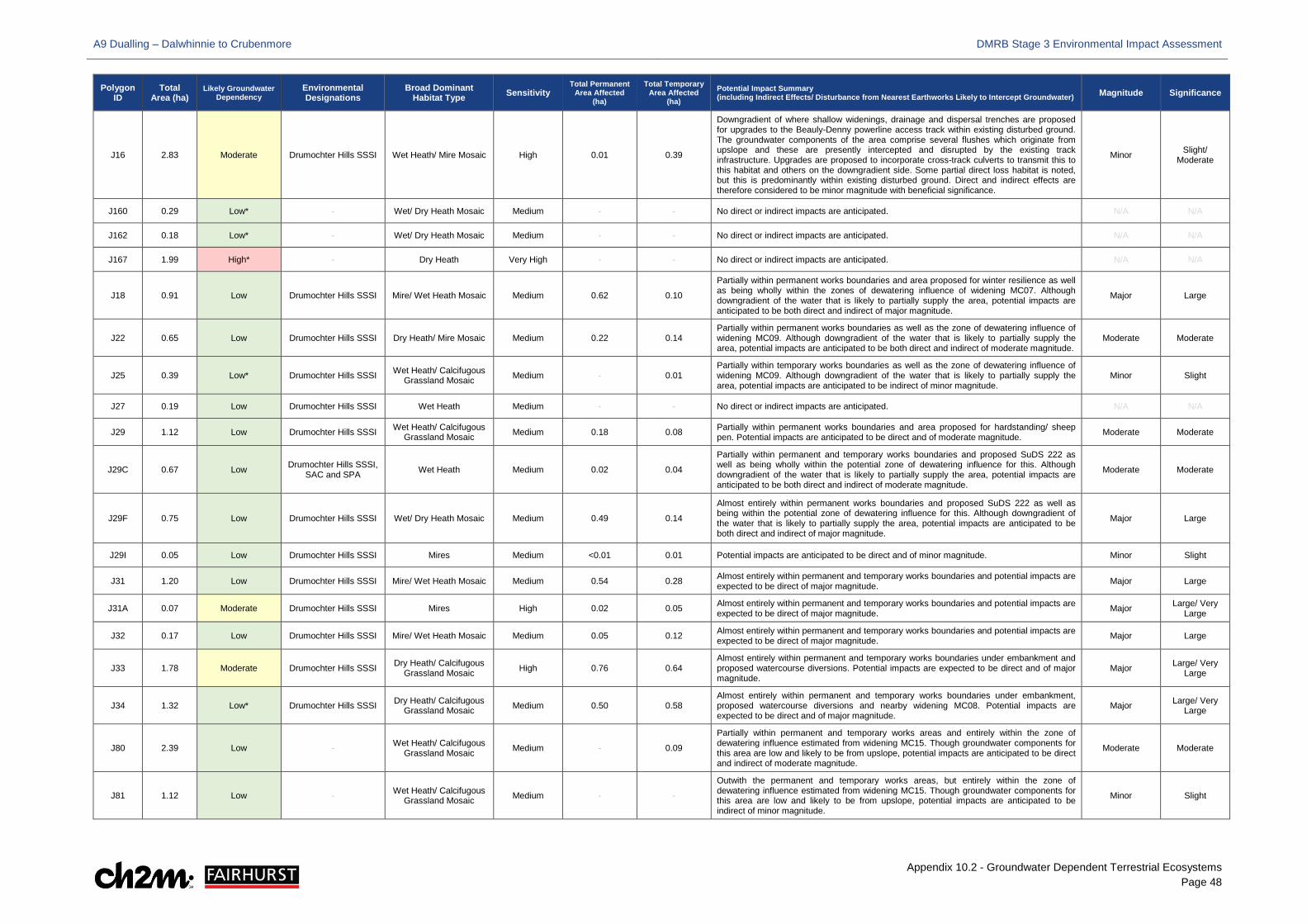
A9 Dualling – Dalwhinnie to Crubenmore DMRB Stage 3 Environmental Impact Assessment
Appendix 10.2 - Groundwater Dependent Terrestrial Ecosystems Page 48
Polygon ID
Total Area (ha)
Likely Groundwater Dependency
Environmental Designations
Broad Dominant Habitat Type Sensitivity
Total Permanent Area Affected
(ha)
Total Temporary Area Affected
(ha) Potential Impact Summary (including Indirect Effects/ Disturbance from Nearest Earthworks Likely to Intercept Groundwater) Magnitude Significance
J16 2.83 Moderate Drumochter Hills SSSI Wet Heath/ Mire Mosaic High 0.01 0.39
Downgradient of where shallow widenings, drainage and dispersal trenches are proposed for upgrades to the Beauly-Denny powerline access track within existing disturbed ground. The groundwater components of the area comprise several flushes which originate from upslope and these are presently intercepted and disrupted by the existing track infrastructure. Upgrades are proposed to incorporate cross-track culverts to transmit this to this habitat and others on the downgradient side. Some partial direct loss habitat is noted, but this is predominantly within existing disturbed ground. Direct and indirect effects are therefore considered to be minor magnitude with beneficial significance.
Minor Slight/ Moderate
J160 0.29 Low* - Wet/ Dry Heath Mosaic Medium - - No direct or indirect impacts are anticipated. N/A N/A
J162 0.18 Low* - Wet/ Dry Heath Mosaic Medium - - No direct or indirect impacts are anticipated. N/A N/A
J167 1.99 High* - Dry Heath Very High - - No direct or indirect impacts are anticipated. N/A N/A
J18 0.91 Low Drumochter Hills SSSI Mire/ Wet Heath Mosaic Medium 0.62 0.10
Partially within permanent works boundaries and area proposed for winter resilience as well as being wholly within the zones of dewatering influence of widening MC07. Although downgradient of the water that is likely to partially supply the area, potential impacts are anticipated to be both direct and indirect of major magnitude.
Major Large
J22 0.65 Low Drumochter Hills SSSI Dry Heath/ Mire Mosaic Medium 0.22 0.14 Partially within permanent works boundaries as well as the zone of dewatering influence of widening MC09. Although downgradient of the water that is likely to partially supply the area, potential impacts are anticipated to be both direct and indirect of moderate magnitude.
Moderate Moderate
J25 0.39 Low* Drumochter Hills SSSI Wet Heath/ Calcifugous Grassland Mosaic Medium - 0.01
Partially within temporary works boundaries as well as the zone of dewatering influence of widening MC09. Although downgradient of the water that is likely to partially supply the area, potential impacts are anticipated to be indirect of minor magnitude.
Minor Slight
J27 0.19 Low Drumochter Hills SSSI Wet Heath Medium - - No direct or indirect impacts are anticipated. N/A N/A
J29 1.12 Low Drumochter Hills SSSI Wet Heath/ Calcifugous Grassland Mosaic Medium 0.18 0.08 Partially within permanent works boundaries and area proposed for hardstanding/ sheep
pen. Potential impacts are anticipated to be direct and of moderate magnitude. Moderate Moderate
J29C 0.67 Low Drumochter Hills SSSI, SAC and SPA Wet Heath Medium 0.02 0.04
Partially within permanent and temporary works boundaries and proposed SuDS 222 as well as being wholly within the potential zone of dewatering influence for this. Although downgradient of the water that is likely to partially supply the area, potential impacts are anticipated to be both direct and indirect of moderate magnitude.
Moderate Moderate
J29F 0.75 Low Drumochter Hills SSSI Wet/ Dry Heath Mosaic Medium 0.49 0.14
Almost entirely within permanent works boundaries and proposed SuDS 222 as well as being within the potential zone of dewatering influence for this. Although downgradient of the water that is likely to partially supply the area, potential impacts are anticipated to be both direct and indirect of major magnitude.
Major Large
J29I 0.05 Low Drumochter Hills SSSI Mires Medium <0.01 0.01 Potential impacts are anticipated to be direct and of minor magnitude. Minor Slight
J31 1.20 Low Drumochter Hills SSSI Mire/ Wet Heath Mosaic Medium 0.54 0.28 Almost entirely within permanent and temporary works boundaries and potential impacts are expected to be direct of major magnitude. Major Large
J31A 0.07 Moderate Drumochter Hills SSSI Mires High 0.02 0.05 Almost entirely within permanent and temporary works boundaries and potential impacts are expected to be direct of major magnitude. Major Large/ Very
Large
J32 0.17 Low Drumochter Hills SSSI Mire/ Wet Heath Mosaic Medium 0.05 0.12 Almost entirely within permanent and temporary works boundaries and potential impacts are expected to be direct of major magnitude. Major Large
J33 1.78 Moderate Drumochter Hills SSSI Dry Heath/ Calcifugous Grassland Mosaic High 0.76 0.64
Almost entirely within permanent and temporary works boundaries under embankment and proposed watercourse diversions. Potential impacts are expected to be direct and of major magnitude.
Major Large/ Very Large
J34 1.32 Low* Drumochter Hills SSSI Dry Heath/ Calcifugous Grassland Mosaic Medium 0.50 0.58
Almost entirely within permanent and temporary works boundaries under embankment, proposed watercourse diversions and nearby widening MC08. Potential impacts are expected to be direct and of major magnitude.
Major Large/ Very Large
J80 2.39 Low - Wet Heath/ Calcifugous Grassland Mosaic Medium - 0.09
Partially within permanent and temporary works areas and entirely within the zone of dewatering influence estimated from widening MC15. Though groundwater components for this area are low and likely to be from upslope, potential impacts are anticipated to be direct and indirect of moderate magnitude.
Moderate Moderate
J81 1.12 Low - Wet Heath/ Calcifugous Grassland Mosaic Medium - -
Outwith the permanent and temporary works areas, but entirely within the zone of dewatering influence estimated from widening MC15. Though groundwater components for this area are low and likely to be from upslope, potential impacts are anticipated to be indirect of minor magnitude.
Minor Slight
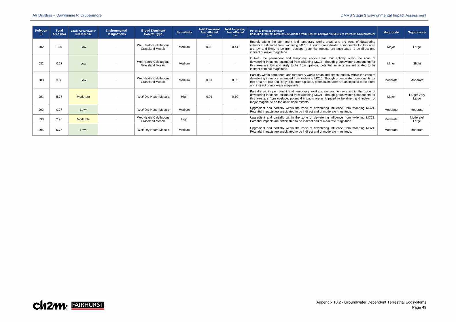
A9 Dualling – Dalwhinnie to Crubenmore DMRB Stage 3 Environmental Impact Assessment
Appendix 10.2 - Groundwater Dependent Terrestrial Ecosystems Page 49
Polygon ID
Total Area (ha)
Likely Groundwater Dependency
Environmental Designations
Broad Dominant Habitat Type Sensitivity
Total Permanent Area Affected
(ha)
Total Temporary Area Affected
(ha) Potential Impact Summary (including Indirect Effects/ Disturbance from Nearest Earthworks Likely to Intercept Groundwater) Magnitude Significance
J82 1.04 Low - Wet Heath/ Calcifugous Grassland Mosaic Medium 0.60 0.44
Entirely within the permanent and temporary works areas and the zone of dewatering influence estimated from widening MC15. Though groundwater components for this area are low and likely to be from upslope, potential impacts are anticipated to be direct and indirect of major magnitude.
Major Large
J82 0.17 Low - Wet Heath/ Calcifugous Grassland Mosaic Medium - -
Outwith the permanent and temporary works areas, but entirely within the zone of dewatering influence estimated from widening MC15. Though groundwater components for this area are low and likely to be from upslope, potential impacts are anticipated to be indirect of minor magnitude.
Minor Slight
J83 3.30 Low - Wet Heath/ Calcifugous Grassland Mosaic Medium 0.61 0.33
Partially within permanent and temporary works areas and almost entirely within the zone of dewatering influence estimated from widening MC15. Though groundwater components for this area are low and likely to be from upslope, potential impacts are anticipated to be direct and indirect of moderate magnitude.
Moderate Moderate
J91 5.78 Moderate - Wet/ Dry Heath Mosaic High 0.01 0.10
Partially within permanent and temporary works areas and entirely within the zone of dewatering influence estimated from widening MC21. Though groundwater components for this area are from upslope, potential impacts are anticipated to be direct and indirect of major magnitude on the downslope extents.
Major Large/ Very Large
J92 0.77 Low* - Wet/ Dry Heath Mosaic Medium - - Upgradient and partially within the zone of dewatering influence from widening MC21. Potential impacts are anticipated to be indirect and of moderate magnitude. Moderate Moderate
J93 2.45 Moderate - Wet Heath/ Calcifugous Grassland Mosaic High - - Upgradient and partially within the zone of dewatering influence from widening MC21.
Potential impacts are anticipated to be indirect and of moderate magnitude. Moderate Moderate/ Large
J95 0.75 Low* - Wet/ Dry Heath Mosaic Medium - - Upgradient and partially within the zone of dewatering influence from widening MC21. Potential impacts are anticipated to be indirect and of moderate magnitude. Moderate Moderate
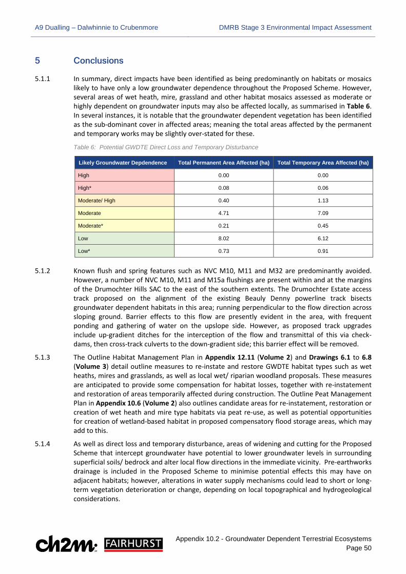
A9 Dualling – Dalwhinnie to Crubenmore DMRB Stage 3 Environmental Impact Assessment
Appendix 10.2 - Groundwater Dependent Terrestrial Ecosystems Page 50
5 Conclusions
5.1.1 In summary, direct impacts have been identified as being predominantly on habitats or mosaics likely to have only a low groundwater dependence throughout the Proposed Scheme. However, several areas of wet heath, mire, grassland and other habitat mosaics assessed as moderate or highly dependent on groundwater inputs may also be affected locally, as summarised in Table 6. In several instances, it is notable that the groundwater dependent vegetation has been identified as the sub-dominant cover in affected areas; meaning the total areas affected by the permanent and temporary works may be slightly over-stated for these.
Table 6: Potential GWDTE Direct Loss and Temporary Disturbance
Likely Groundwater Depdendence Total Permanent Area Affected (ha) Total Temporary Area Affected (ha)
High 0.00 0.00
High* 0.08 0.06
Moderate/ High 0.40 1.13
Moderate 4.71 7.09
Moderate* 0.21 0.45
Low 8.02 6.12
Low* 0.73 0.91
5.1.2 Known flush and spring features such as NVC M10, M11 and M32 are predominantly avoided. However, a number of NVC M10, M11 and M15a flushings are present within and at the margins of the Drumochter Hills SAC to the east of the southern extents. The Drumochter Estate access track proposed on the alignment of the existing Beauly Denny powerline track bisects groundwater dependent habitats in this area; running perpendicular to the flow direction across sloping ground. Barrier effects to this flow are presently evident in the area, with frequent ponding and gathering of water on the upslope side. However, as proposed track upgrades include up-gradient ditches for the interception of the flow and transmittal of this via check-dams, then cross-track culverts to the down-gradient side; this barrier effect will be removed.
5.1.3 The Outline Habitat Management Plan in Appendix 12.11 (Volume 2) and Drawings 6.1 to 6.8 (Volume 3) detail outline measures to re-instate and restore GWDTE habitat types such as wet heaths, mires and grasslands, as well as local wet/ riparian woodland proposals. These measures are anticipated to provide some compensation for habitat losses, together with re-instatement and restoration of areas temporarily affected during construction. The Outline Peat Management Plan in Appendix 10.6 (Volume 2) also outlines candidate areas for re-instatement, restoration or creation of wet heath and mire type habitats via peat re-use, as well as potential opportunities for creation of wetland-based habitat in proposed compensatory flood storage areas, which may add to this.
5.1.4 As well as direct loss and temporary disturbance, areas of widening and cutting for the Proposed Scheme that intercept groundwater have potential to lower groundwater levels in surrounding superficial soils/ bedrock and alter local flow directions in the immediate vicinity. Pre-earthworks drainage is included in the Proposed Scheme to minimise potential effects this may have on adjacent habitats; however, alterations in water supply mechanisms could lead to short or long-term vegetation deterioration or change, depending on local topographical and hydrogeological considerations.
A9 Dualling – Dalwhinnie to Crubenmore DMRB Stage 3 Environmental Impact Assessment
Appendix 10.2 - Groundwater Dependent Terrestrial Ecosystems Page 51
5.1.5 Due to the nature of the existing topography across the Proposed Scheme and that the majority of cuttings relate to widening of existing ones to the east, the impacts on groundwater level and flow in surrounding superficial soils/ bedrock have been assessed as predominantly minor, with localised zones of dewatering influence that are considered unlikely to affect longer-term or ongoing groundwater supply mechanisms to upslope or downslope GWDTE habitats.
5.1.6 More extensive and deeper cuttings are proposed for the Dalwhinnie junction and SSE aqueduct diversion, and the magnitude of potential impacts is assessed higher due to the depths of excavation, drawdown and greater likelihood for local flow patterns to be altered. Potential impacts on groundwater levels and flows in these areas have therefore been assessed as moderate, but equivalent to only partial change or loss of some adjacent GWDTE habitats based on the nature of the water supply mechanisms to these.
5.1.7 Given the nature of these effects, it is difficult to quantify the area of potential GWDTE that may be affected indirectly. However, a detailed assessment of those widening or other cutting areas anticipated to result in indirect groundwater-related impacts on GWDTE is recommended prior to construction. If impacts are confirmed as significant, groundwater exclusion, containment and other measures, such as maintaining natural flows and redirecting abstracted groundwater, will be considered during detailed design and implemented where appropriate. This will be further supplemented by a specific GWDTE monitoring and mitigation plan and further micrositing during detailed design and construction where possible.
5.1.8 Those GWDTE identified to be at risk of impact would be monitored prior to, and following, construction to determine the level of impact from groundwater drawdown in areas of widening or cutting, together with a representative sample of downslope GWDTE. This monitoring would include both groundwater level and repeated NVC surveys, in accordance with SEPA guidance (SEPA, 2014a). In this regard, the monitoring may feature hand-driven groundwater monitoring wells, with a minimum of one upgradient location and two downgradient locations where GWDTE may be impacted. Requirements prior to and following construction would include:
• Pre-construction: a minimum of 10 samples of groundwater level over a minimum of six months prior to construction, including at least five in the summer period
• Post-construction: a minimum of 10 measurements of groundwater level per year, conducted for a minimum of three years until it is demonstrated the receptors are not impacted.
5.1.9 Monitoring during construction phase should also be considered where required in order to provide meaningful indications of the ongoing works, potential adverse impacts and mitigation implementation.
A9 Dualling – Dalwhinnie to Crubenmore DMRB Stage 3 Environmental Impact Assessment
Appendix 10.2 - Groundwater Dependent Terrestrial Ecosystems Page 52
6 References
Botanaeco (2016). Groundwater Dependent Terrestrial Ecosystem (GWDTE) Decision Tool, derived by Dr. Andy McMullen
Cooper, E.A. (1997). Summary Descriptions of National Vegetation Classification grassland and montane communities. ISBN 1 86107 433 3.
Rodwell, J.S. (Ed), et al. (1991 – 2000). British Plant Communities (5 volumes). Cambridge, Cambridge University Press.
Scottish Environment Protection Agency (2014a). Land Use Planning System Guidance Note 31 (LUPS-GU-31) Guidance on Assessing the Impacts of Development Proposals on Groundwater Abstractions and Groundwater Dependent Terrestrial Ecosystems, Version 2
Scottish Environment Protection Agency (2014b). Land Use Planning System SEPA Guidance Note 4: Planning advice on windfarm developments, Issue No: Version 7
Scottish Environment Protection Agency (2017). Interactive River Basin Management Plan Map (Online) Available at (http://gis.sepa.org.uk/rbmp) (Accessed June 2017)
Scottish and Northern Ireland Forum for Environmental Research (SNIFFER) (2007). WFD66: Wetland Hydrogeomorphic Classification for Scotland
SNIFFER (2009). WFD95: A Functional Wetland Typology for Scotland - Field Survey Manual. Version 1.
UKTAG (2004). Guidance on the identification and risk assessment of groundwater dependent terrestrial ecosystems. Work Programme Task 5a + b. Draft, Version 5