aabsys capability statement · this document is submitted solely for recipient's purposes to...
TRANSCRIPT
This document is submitted solely for recipient's purposes to evaluate AABSyS Competency. It may not be duplicated, used, or disclosed in whole or in part for any other purpose without AABSyS prior written permission.
1. EXECUTIVE SUMMARY ..................................................................... ERROR! BOOKMARK NOT DEFINED.
1.1 INTRODUCTION ............................................................................................ ERROR! BOOKMARK NOT DEFINED.
2. UNDERSTANDING OF WORKSHIP REQUIREMENTS..................... ERROR! BOOKMARK NOT DEFINED.
3. PROPOSED TECHNICAL SOLUTION .................................................... ERROR! BOOKMARK NOT DEFINED.
3.1 INTRODUCTION ............................................................................................ ERROR! BOOKMARK NOT DEFINED. 3.2 USER INTERFACE .......................................................................................... ERROR! BOOKMARK NOT DEFINED. 3.3 SOLUTION ARCHITECTURE .............................................................................. ERROR! BOOKMARK NOT DEFINED. 3.4 SECURITY .................................................................................................... ERROR! BOOKMARK NOT DEFINED. 3.5 PERFORMANCE ............................................................................................ ERROR! BOOKMARK NOT DEFINED. 3.6 LOCALIZATION AND INTERNALIZATION .............................................................. ERROR! BOOKMARK NOT DEFINED. 3.7 DEPLOYMENT ARCHITECTURE ......................................................................... ERROR! BOOKMARK NOT DEFINED. 3.8 NATIVE MOBILE APPS ................................................................................... ERROR! BOOKMARK NOT DEFINED. 3.9 SOFTWARE AND HARDWARE REQUIREMENTS .................................................... ERROR! BOOKMARK NOT DEFINED.
4. METHODOLOGY ............................................................................... ERROR! BOOKMARK NOT DEFINED.
5. WARRANTY ...................................................................................... ERROR! BOOKMARK NOT DEFINED.
6. PROJECT COSTS ................................................................................ ERROR! BOOKMARK NOT DEFINED.
7. ANNUAL MAINTENANCE CONTRACT (AMC) ..................................... ERROR! BOOKMARK NOT DEFINED.
8. PROJECT TIMELIMES AND DELIVERABLES ......................................... ERROR! BOOKMARK NOT DEFINED.
9. CHANGE CONTROL AND MANAGEMENT .......................................... ERROR! BOOKMARK NOT DEFINED.
10. PAYMENT TERMS ........................................................................... ERROR! BOOKMARK NOT DEFINED.
11. EXCLUSIONS ................................................................................... ERROR! BOOKMARK NOT DEFINED.
12. AABSYS TERMS AND CONDITIONS .................................................. ERROR! BOOKMARK NOT DEFINED.
AABSyS CAPABILITY STATEMENT
Corporate Office
Plot No. E/54 &E/54/1, Infocity Chandaka Industrial Estate, Patia Bhubaneshwar - 751024 Odisha, India
Global Sales Office
Unit no. 3515 & 3516, 5th Floor, Tower 3, B-36, Express Trade Towers, Expressway, Sector 132, Noida - 201301, UP, INDIA

This document is submitted solely for recipient's purposes to evaluate AABSyS Competency. It may not be duplicated, used, or disclosed in whole or in part for any other purpose without AABSyS prior written permission.
1. COMPANY PROFILE ......................................................................................... 3
1.1 MANAGEMENT ................................................................................................................................... 3 1.2 OFFICE AND TEAM .............................................................................................................................. 3 1.3 INFRASTRUCTURE ................................................................................................................................ 4
2. AABSYS GEOSPATIAL SERVICES ............................................................................ 6
2.1 INTRODUCTION ................................................................................................................................... 6 2.2 GIS MAPPING .................................................................................................................................... 7 2.2.1 GIS MAPPING SERVICES ....................................................................................................................... 7 2.2.2 REMOTE SENSING SERVICES .................................................................................................................. 7 2.2.3 PHOTOGRAMMETRY SERVICES ............................................................................................................... 8 2.3 POLE LOADING ANALYSIS SERVICES FOR THE UTILITY INDUSTRY .................................................................... 8 2.4 CAFM/CAD 2D & 3D SERVICES .......................................................................................................... 8 2.5 GIS SURVEY ..................................................................................................................................... 10 2.6 INDOOR MAPS & NAVIGATION ............................................................................................................ 10 2.7 GEOCODED & PHOTOREALISTIC 3D MODELS .......................................................................................... 10 2.8 TECHNOLOGY PLATFORMS AND SOFTWARE ............................................................................................ 11 2.9 DOMAINS WE SERVE ......................................................................................................................... 11 2.10 PARTIAL CUSTOMER LIST .................................................................................................................... 12 2.11 TESTIMONIALS .................................................................................................................................. 13
3. AABSYS SOFTWARE SERVICES ........................................................................... 14
3.1 GEOSPATIAL SOLUTIONS ..................................................................................................................... 14 3.2 APPLICATION DEVELOPMENT AND MAINTENANCE ................................................................................... 14 3.3 SOFTWARE PRODUCT ENGINEERING ..................................................................................................... 15 3.4 MOBILITY ........................................................................................................................................ 15 3.5 INDEPENDENT TESTING ...................................................................................................................... 15 3.6 CLOUD COMPUTING .......................................................................................................................... 15 3.7 TECHNOLOGY FOCUS ......................................................................................................................... 15 3.8 TECHNOLOGY EXPERTISE..................................................................................................................... 16 3.9 METHODOLOGY ................................................................................................................................ 16 3.10 GOVERNANCE MODEL ....................................................................................................................... 17 3.11 PARTIAL CUSTOMER LIST .................................................................................................................... 17
4. PROJECT EXPERIENCE (GIS, CAD & SOFTWARE) ........................................................ 18
5. ENGAGEMENT MODEL ................................................................................... 21
6. PRICING MODELS ......................................................................................... 21
7. QUALITY AND PROJECT MANAGEMENT ................................................................ 21
7.1 QUALITY POLICY ............................................................................................................................... 22 7.2 ISO CERTIFICATIONS .......................................................................................................................... 22 7.3 PROJECT MANAGEMENT .................................................................................................................... 23
8. PROFESSIONAL MEMBERSHIP ........................................................................... 23
9. CORPORATE CULTURE AND CORE VALUES .............................................................. 23
10. RESOURCE PROFILE (SNAPSHOT OF PROFICIENCY) ................................................. 25
11. AABSYS DIFFERENTIATORS ............................................................................ 26
This document is submitted solely for recipient's purposes to evaluate AABSyS Competency. It may not be duplicated, used, or disclosed in whole or in part for any other purpose without AABSyS prior written permission.
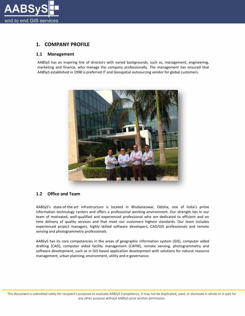
1. COMPANY PROFILE
1.1 Management
AABSyS has an inspiring line of directors with varied backgrounds, such as, management, engineering, marketing and finance, who manage the company professionally. The management has ensured that AABSyS established in 1998 is preferred IT and Geospatial outsourcing vendor for global customers.
1.2 Office and Team
AABSyS's state-of-the-art infrastructure is located in Bhubaneswar, Odisha, one of India's prime information technology centers and offers a professional working environment. Our strength lies in our team of motivated, well-qualified and experienced professional who are dedicated to efficient and on time delivery of quality services and that meet our customers highest standards. Our team includes experienced project managers, highly skilled software developers, CAD/GIS professionals and remote sensing and photogrammetry professionals. AABSyS has its core competencies in the areas of geographic information system (GIS), computer aided drafting (CAD), computer aided facility management (CAFM), remote sensing, photogrammetry and software development, such as in GIS based application development with solutions for natural resource management, urban planning, environment, utility and e-governance.

This document is submitted solely for recipient's purposes to evaluate AABSyS Competency. It may not be duplicated, used, or disclosed in whole or in part for any other purpose without AABSyS prior written permission.
1.3 Infrastructure
AABSyS's state-of-the art infrastructure is located in Infocity Bhubaneswar, Orissa: one of India's prime information technology centers and offers a professional working environment. It is well connected to National and International destinations by road, rail and air and is situated in close proximity to International hotels. The presence of many engineering colleges and research institutions in Bhubaneswar assures the disposal of a pool of highly educated, young computer engineers and IT professionals.
Infrastructure & Facilities
Dedicated software development center spread across 55,000 Sq. ft. for 350 IT professionals.
Plotters, scanners and printers apart from other supporting systems
Licensed software’s for all production processes
Central air-conditioning
Dedicated high speed internet bandwidth access
24 hours IT support
Firewall and network security
Power back-up and generator
Conference rooms
Canteen and relaxation rooms
Private security
Parking
This document is submitted solely for recipient's purposes to evaluate AABSyS Competency. It may not be duplicated, used, or disclosed in whole or in part for any other purpose without AABSyS prior written permission.
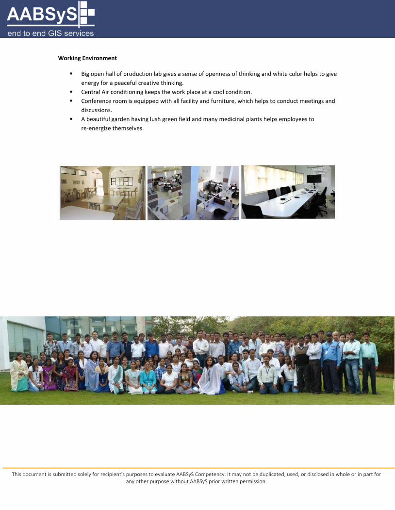
Working Environment
Big open hall of production lab gives a sense of openness of thinking and white color helps to give
energy for a peaceful creative thinking.
Central Air conditioning keeps the work place at a cool condition.
Conference room is equipped with all facility and furniture, which helps to conduct meetings and
discussions.
A beautiful garden having lush green field and many medicinal plants helps employees to
re-energize themselves.
This document is submitted solely for recipient's purposes to evaluate AABSyS Competency. It may not be duplicated, used, or disclosed in whole or in part for any other purpose without AABSyS prior written permission.
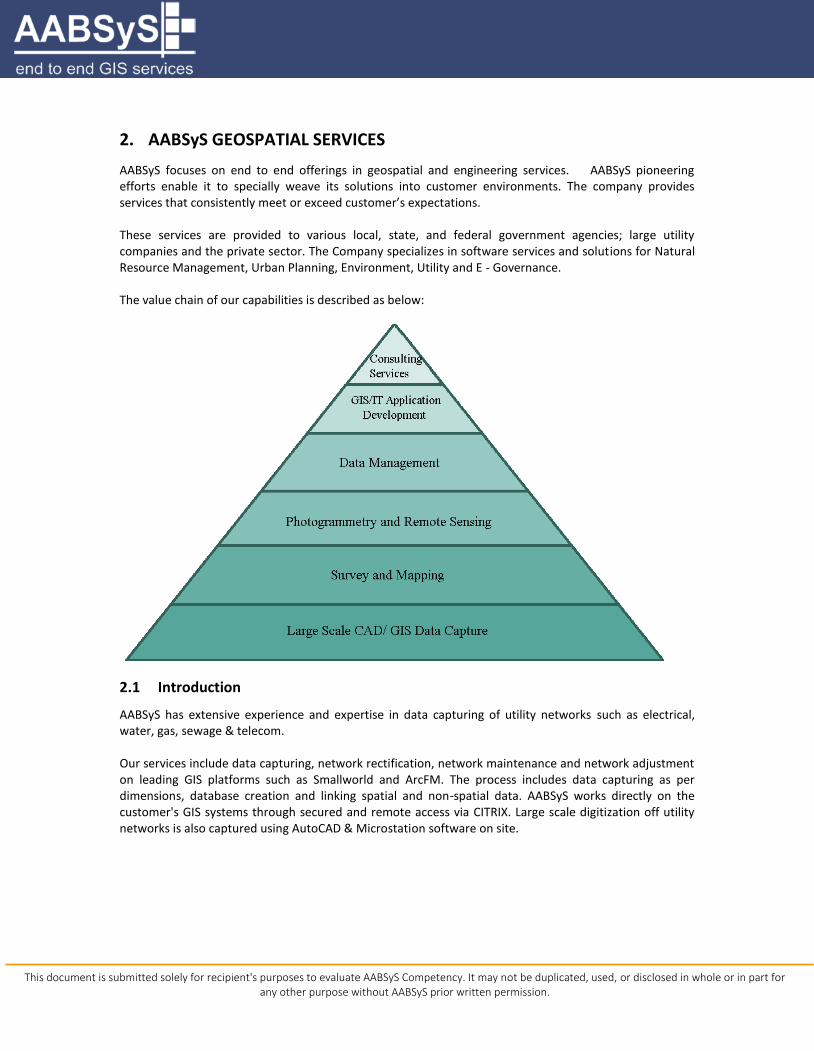
2. AABSyS GEOSPATIAL SERVICES
AABSyS focuses on end to end offerings in geospatial and engineering services. AABSyS pioneering efforts enable it to specially weave its solutions into customer environments. The company provides services that consistently meet or exceed customer’s expectations. These services are provided to various local, state, and federal government agencies; large utility companies and the private sector. The Company specializes in software services and solutions for Natural Resource Management, Urban Planning, Environment, Utility and E - Governance. The value chain of our capabilities is described as below:
2.1 Introduction
AABSyS has extensive experience and expertise in data capturing of utility networks such as electrical, water, gas, sewage & telecom. Our services include data capturing, network rectification, network maintenance and network adjustment on leading GIS platforms such as Smallworld and ArcFM. The process includes data capturing as per dimensions, database creation and linking spatial and non-spatial data. AABSyS works directly on the customer's GIS systems through secured and remote access via CITRIX. Large scale digitization off utility networks is also captured using AutoCAD & Microstation software on site.
This document is submitted solely for recipient's purposes to evaluate AABSyS Competency. It may not be duplicated, used, or disclosed in whole or in part for any other purpose without AABSyS prior written permission.
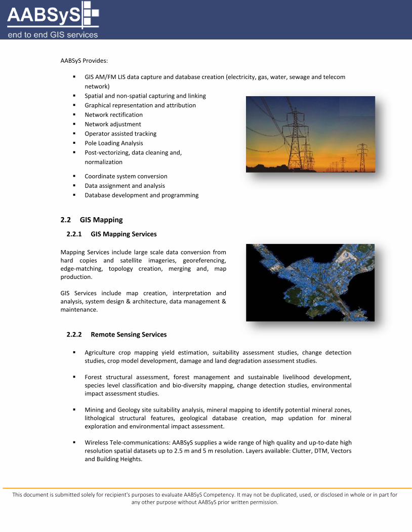
AABSyS Provides:
GIS AM/FM LIS data capture and database creation (electricity, gas, water, sewage and telecom
network)
Spatial and non-spatial capturing and linking
Graphical representation and attribution
Network rectification
Network adjustment
Operator assisted tracking
Pole Loading Analysis
Post-vectorizing, data cleaning and,
normalization
Coordinate system conversion
Data assignment and analysis
Database development and programming
2.2 GIS Mapping
2.2.1 GIS Mapping Services
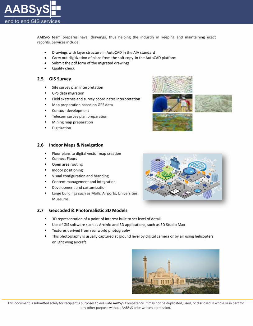
Mapping Services include large scale data conversion from hard copies and satellite imageries, georeferencing, edge-matching, topology creation, merging and, map production.
GIS Services include map creation, interpretation and analysis, system design & architecture, data management & maintenance.
2.2.2 Remote Sensing Services
Agriculture crop mapping yield estimation, suitability assessment studies, change detection studies, crop model development, damage and land degradation assessment studies.
Forest structural assessment, forest management and sustainable livelihood development, species level classification and bio-diversity mapping, change detection studies, environmental impact assessment studies.
Mining and Geology site suitability analysis, mineral mapping to identify potential mineral zones, lithological structural features, geological database creation, map updation for mineral exploration and environmental impact assessment.
Wireless Tele-communications: AABSyS supplies a wide range of high quality and up-to-date high resolution spatial datasets up to 2.5 m and 5 m resolution. Layers available: Clutter, DTM, Vectors and Building Heights.

This document is submitted solely for recipient's purposes to evaluate AABSyS Competency. It may not be duplicated, used, or disclosed in whole or in part for any other purpose without AABSyS prior written permission.
2.2.3 Photogrammetry Services Photogrammetry services include aerial triangulation, creating mosaics, edge matching, tile generation in user defined dimensions, planimetric feature extraction, contour generation, ortho-photo generation, ortho-rectification, creation of DEM, DTM and DSM, LIDAR data processing and 3D city modelling.
2.3 Pole Loading Analysis Services for the Utility Industry
The establishment of timelines expedited the “make-ready” process considerably and NESC (National Electrical Safety Code) set the ground rules for safety compliance. In order to ensure compliance with NESC, joint use pole owners have to conduct utility pole inspections, including the pole loading analysis, before they allow a communication company to attach a new equipment to it. The pole loading analysis helps estimate and mitigate risk factors. Pole audit, engineering, and make ready program, maintain the structural integrity of the utility’s aerial distribution and transmission systems while still meeting the fast-paced demands of the attaching telecommunication companies. AABSyS is a leading provider of pole loading analysis services for the utilities industry. With data received from the customer's field staff, AABSyS engineering team can provide detailed pole-level analytics, including the following:
Structural analysis
Stress analysis
Clearance analysis
Reporting of high-risk field assets
Pole replacement design
Make-ready design
2.4 CAFM/CAD 2D & 3D Services
AABSyS provides services for large-scale 2D & 3D CAD drafting, paper to CAD conversion, raster to vector conversion for architectural 7 facility management plans, plumbing plans, structural plans and engineering drawing on leading CAD platform such as AutoCAD and Microstation.
AABSyS has knowledge in CAD programs such as ArchiCAD, ADT, Revit and 3D Studio Max. We provide 3D views, sectional plans and elevation plans based on customers’ requirements. AABSyS CAD professionals possess high skills and expertise in preparing 3D models, rendering and walk through for residential and commercial buildings. Specific attention is given for grid alignment, capturing dimensions accurately, drafting of slanting roofs etc. AABSyS works in citrix on AutoCAD, Archibus and CAD Overlay using web based facility management applications. The typical work includes drafting of floor plans based on paper drawings or rough sketches of building plans, gathering and preparing building and property information from supplied data sheets or

This document is submitted solely for recipient's purposes to evaluate AABSyS Competency. It may not be duplicated, used, or disclosed in whole or in part for any other purpose without AABSyS prior written permission.
field sketches, assigning space characteristics and usage information, including employee or occupancy data and placing workplace assets such as furniture and equipment.
2.4.1 Solar Panel Design
Solar Panels with photovoltaic power systems are designed to convert sunlight directly into electricity. In case of construction and maintenance of large solar farms, an ideal solar panel layout plan is required. With its rich experience in drafting plans, layout design and template generation, AABSyS positions itself as a one-stop solution provider for specialized services in solar panel layout designs.
With data received from the client, AABSyS team prepares solar panel site template and designs, thus helping the solar utility industry in planning and decision making. This includes:
Layout Review: A brief info about the site location and the technical specifications
Solar panel design: It is done with the input drawings
Extra amenities: Features like capacity, pitch, evacuation location, inverter location, lightning
arrester placement are added as part of the layout
Site plan: Drafted with the help of the input files
2.4.2 Naval Architecture
AABSyS has been supporting shipping and maritime consultants by providing design drafting and data conversion services for their naval drawings, wherein the rough inputs received from customers are drafted in the AutoCAD platform, with the exact dimensions.
This document is submitted solely for recipient's purposes to evaluate AABSyS Competency. It may not be duplicated, used, or disclosed in whole or in part for any other purpose without AABSyS prior written permission.
AABSyS team prepares naval drawings, thus helping the industry in keeping and maintaining exact records. Services include:
Drawings with layer structure in AutoCAD in the AIA standard
Carry out digitization of plans from the soft copy in the AutoCAD platform
Submit the pdf form of the migrated drawings
Quality check
2.5 GIS Survey
Site survey plan interpretation
GPS data migration
Field sketches and survey coordinates interpretation
Map preparation based on GPS data
Contour development
Telecom survey plan preparation
Mining map preparation
Digitization
2.6 Indoor Maps & Navigation
Floor plans to digital vector map creation Connect Floors
Open area routing
Indoor positioning
Visual configuration and branding
Content management and integration
Development and customization
Large buildings such as Malls, Airports, Universities,
Museums.
2.7 Geocoded & Photorealistic 3D Models
3D representation of a point of interest built to set level of detail.
Use of GIS software such as ArcInfo and 3D applications, such as 3D Studio Max
Textures derived from real world photography
This photography is usually captured at ground level by digital camera or by air using helicopters
or light wing aircraft

This document is submitted solely for recipient's purposes to evaluate AABSyS Competency. It may not be duplicated, used, or disclosed in whole or in part for any other purpose without AABSyS prior written permission.
2.8 Technology Platforms and Software
ESRI Products – ArcGIS, ArcGIS Server,
ArcFM, ArcFM UT
Intergraph
GE Smallworld – Smallworld Core, SIAS
Map Info - MapInfo Professional, MapX,
MapXtreme
Autodesk Products
Microstation
ArchiCAD
O-Calc Pro
Carlson Survey
Ericsson Network Engineer
Adjust IT
Spatial NET
ERDAS Imagine
Z/I Suite – SSK
Leica Photogrammetry Suite (LPS)
Servers: Geo Server, Map Server, OpenLayers,
ERDAS Apollo
Vectorworks
3D Studio MAX
TerraSolid
2.9 Domains We Serve
AABSyS caters to customers in the following Industry verticals:
LAND & URBAN
GIS data capture
Cadastral map data capture
Contour data capturing
Land Records
Land Use / Land Cover
Block and Parcel data capture
Agricultural Mapping
Web GIS Applications
Transportation & Retail Mapping
TELECOM
Network Planning
Network Modeling
ISP and OSP Network Mapping
Fibre Network Design and Data Mapping
Copper OSP and ISP Data Mapping
Integration with Legacy Systems
Land Base and Network Asset Mapping
Data Migration and Integration
WATER & SEWERAGE
Distribution Network
Mapping of Valves and
Distribution Points
Leak History Data
Trouble call Analysis
GAS
Corridor Mapping
New Connections
Planning new lateral Lines
Trouble Call Analysis
Identification of Mains & Switches
ELECTRIC
Network Mapping
Network Re-Alignment
AM/FM Mapping
Consumer Indexing
Network Topology
Spatial Analysis
ENVIRONMENT
Disaster Management
Flood Mapping
Waste water Management
Forestry Mapping
Wetland Mapping
Climate Analysis Maps

This document is submitted solely for recipient's purposes to evaluate AABSyS Competency. It may not be duplicated, used, or disclosed in whole or in part for any other purpose without AABSyS prior written permission.
Energy Auditing
Network Analysis
Pole Loading Analysis
Customized GIS Applications
CAD & AEC
Architectural 3D Floor Plan
BIM Services
2D & 3D CAD Modeling
3D Rendering & Digitizing
3D Walk-through Animation
GEODATA AGGREGATORS
Navigation
Business Intelligence
Location Based Services (LBS)
Value Added Services (VAS)
In-building Data
2.10 Partial Customer List
DOMAIN CUSTOMERS
GIS DATA CAPTURE
Orissa Computer Application Centre, India
Assam Remote Sensing Application Centre, India
NLRMP, India
National Thermal Power Corporation, India
Bhubaneswar Development Authority, India
Commissionerate Police, Orissa
J & S Distributions, US
Ortel Communications, Orissa
Pilatus, Switzerland
Computa Maps, South Africa
ELECTRIC POWERCO
HTZ AG, Switzerland
TELECOM we-do-IT (NBN), Nickel GmbH
WATER/SEWERAGE LIENHARD AG, Switzerland
GAS NETWORKS Mettenmeir, Germany
WE-DO-IT, Australia
LAND ADMINISTRATION Geologia Ecologia Agricoltura (GEA), Italy
Steel Authority of India, India
REMOTE SENSING
& PHOTOGRAMMETRY
EFTAS, Germany
National Geographical Institute, Belgium
Karlsruhe University, Germany
Dept of Forest, Govt Of Orissa, India
AABSyS has several customers from each of the domains. The above is a partial list of our Customer base.

This document is submitted solely for recipient's purposes to evaluate AABSyS Competency. It may not be duplicated, used, or disclosed in whole or in part for any other purpose without AABSyS prior written permission.
2.11 Testimonials
CUSTOMERS TESTIMONIALS
PowerCo – New Zealand 2nd largest Utility Company.
The consistent throughput from the AABSyS team meant that the quality assurance staffs at the PowerCo end were constantly active and that the project's finish date could be forecast accurately. The project has completed successful with the desired end result, which means that PowerCo now has up-to-date information for its business units that rely on GIS data.
We Do IT – Australia – Leading GIS Consultant from Australia with Global Customer’s
"We went through a careful pre-selection process for an overseas outsourcing partner and spent considerable time visiting short-listed companies in India. AABSyS differentiated through their class facility, easy access to nearby education talent pools, high staff retention, their strong financial position and years of experience providing GIS Data Services including Smallworld GIS and ESRI expertise"
HTZ AG, Switzerland – Consultant "AABSyS's continued interaction with customers is impressive. This has resulted in high quality and smooth execution of large scale projects without delay". Swiss client on why he preferred AABSyS to other vendors.

This document is submitted solely for recipient's purposes to evaluate AABSyS Competency. It may not be duplicated, used, or disclosed in whole or in part for any other purpose without AABSyS prior written permission.
3. AABSyS SOFTWARE SERVICES
AABSyS focuses on end to end offerings in software services. AABSyS pioneering efforts enable it to
specially weave its solutions into customer environments. The company provides services that
consistently meet or exceed customer’s expectations.
These services are provided to various local, state, and federal government agencies; large companies and
the private sector.
AABSyS provides:
Geospatial solutions
Application development and maintenance
Software product engineering
Mobility
Independent testing
Cloud computing
3.1 Geospatial Solutions
AABSyS has extensive experience and expertise in geospatial solutions such as
Enterprise GIS
Web GIS
Mobile GIS
Application Integration
Application Migration
AABSyS geospatial solutions include solution design and architecture, desktop and web application
development and maintenance, mobile development and consultancy.
3.2 Application Development and Maintenance
AABSyS application development and maintenance services include:
User experience design
Technical Architecture
Design and Development
Technology upgrade
Performance and Load testing
Application Maintenance services

This document is submitted solely for recipient's purposes to evaluate AABSyS Competency. It may not be duplicated, used, or disclosed in whole or in part for any other purpose without AABSyS prior written permission.
3.3 Software Product Engineering
Concept ideation
Architecture and design
Development
Testing and release
Support
Maintenance
3.4 Mobility
Mobile Application development
Enterprise Mobility
Mobile Testing
3.5 Independent Testing
Performance testing
Mobile application testing
Security testing
Test automation
3.6 Cloud Computing
Amazon web services
Microsoft Azure
3.7 Technology Focus
Geospatial
Microsoft
Java
Open Source
Rich Internet Application
Mobility
Cloud Computing
This document is submitted solely for recipient's purposes to evaluate AABSyS Competency. It may not be duplicated, used, or disclosed in whole or in part for any other purpose without AABSyS prior written permission.
3.8 Technology Expertise
3.9 Methodology
AGILE
AABSyS follows the Agile software development methodology based on iterative and incremental development. The approach provides adaptive planning, development and delivery in a time boxed approach which provides rapid and flexible response to change.

This document is submitted solely for recipient's purposes to evaluate AABSyS Competency. It may not be duplicated, used, or disclosed in whole or in part for any other purpose without AABSyS prior written permission.
3.10 Governance Model
Issue management
AABSYS has a process oriented escalation and issue management procedure in place to resolve all type of problems and issues arising in an engagement. There is in place a well-defined escalation hierarchy levels within AABSyS.
Change Management
Any changes to the agreed Functional and Non-functional requirements are handled via the Change Request form and the changes are negotiated.
3.11 Partial Customer List
AABSyS has several customers from each of the domains. The above is a partial list of our Customer base.
DOMAIN CUSTOMERS
Real Estate Gharabari Info Pvt. Ltd., India
RealZu, Caymon Islands
Web Application LLC INC, Caymon Islands
Directorate of Fisheries of Orissa
Tech Sedo,USA
Sutra Consulting, India
Tata Steel,India
Mobile Application(Villa Property Management)
Paul Manester, USA
ESRI GIS Pisys Marine Limited, UK

This document is submitted solely for recipient's purposes to evaluate AABSyS Competency. It may not be duplicated, used, or disclosed in whole or in part for any other purpose without AABSyS prior written permission.
4. PROJECT EXPERIENCE (GIS, CAD & SOFTWARE)
PROJECT EXPERIENCE IN GIS
Project Client Brief Description
Telecom Fiber Network Design and data capture for NBN
we-do-IT Designing and data capture of physical wireline/broadband network for the new estates, backhaul design and As-built survey packs
Capturing of Electricity Distribution Network and Assets data
Mettenmeir
The project involved capture of Electricity distribution network and assets from paper maps in conjunction with ground cadaster map. The ground cadaster map data was supplied as a SmallWorld Object Class. Scope of work at AABSyS was to capture the electricity network (High, Medium, Lower voltage cables and objects such as stations, distributors, joints etc. along with the street light and house service cables in detail scale.
Capturing of Optical fiber network data
Nickel GmbH The project required detailed telecom network inventory mapping and asset detailing for the fiber optic cable network.
Capturing of Electricity Distribution Network and Assets data
POWERCO The project involved capture of Electricity distribution and transmission network data along with associated assets.
Data Migration of GAS pipe asset data
Mettenmeir
The data was migrated from different platforms such as AutoCAD, Microstation, Intergraph, etc in overview scale and client wanted to bring into a single network system. ABSYS Scope of work was to capture the data in detail with all the pipe objects, dimensions, labeling and some missing topographical objects.
Seamless data migration of water distribution network
LIENHARD AG Project required migration of data that was originally in the paper form and AutoCAD DWG format to Microstation DGN.
Electrical Utility data capture HTZ AG Digitization of Utility Network. Mosaic and Geo-reference them into seamless map.

This document is submitted solely for recipient's purposes to evaluate AABSyS Competency. It may not be duplicated, used, or disclosed in whole or in part for any other purpose without AABSyS prior written permission.
PROJECT EXPERIENCE IN CAD
Project Client Brief Description
Digitization of transformer drawings in AutoCAD environment
BHEL The project involved digitization of 12000 special transformer drawings in AutoCAD for Transformer Engineering Department of BHEL, Jhansi.
Digitization of Engineering drawings
easyCAD.ch Digitization of Engineering drawings viz. Mechanical, Structural, Architectural, Civil engineering drawings using AutoCAD.
Digitization of Architectural drawings
Photoplan
AABSyS captured high quality visual architectural and Interior Imagery using AutoCAD / Autodesk 3DS Max for 2D and3D designs (floor plans). AABSyS Scope of work was to draft the floor plan using customer provided standard with reference to the specified dimensions, Sanitary objects, Room labels and Gross Internal area of the building. Later the same 2D drafted floor plans are used to develop the 3D models of the floor plans.
Design / Drafting of Engineering drawings (Architecture)
MECON
The project involved preparation of architectural design scheme, and detailed drawings showing all relevant plans, elevations and sections at various levels and locations indicating complete configuration of all work with the desired specification
Digitization of Engineering drawings
HTZ AG The project required digitization of engineering drawings viz. Mechanical, Structural, Architectural, Civil engineering drawings using AutoCAD.

This document is submitted solely for recipient's purposes to evaluate AABSyS Competency. It may not be duplicated, used, or disclosed in whole or in part for any other purpose without AABSyS prior written permission.
PROJECT EXPERIENCE IN SOFTWARE
Project Client Brief Description
ARCS GIS software development for ARC Map
Pisys Marine Ltd
The project is to develop Software for GIS that decrypts the rich marine information provided by the UK Hydrographic Office, enabling the data to be used in a desktop GIS (Geographic Information System). ARCS GIS is rare among information systems as it is not only capable of assembling, storing, manipulating and displaying geographically referenced information, but integrates this with a company’s own information. The customer will be able to create their own datasets and reports using standard GIS functionality on top of high quality worldwide charting data set.
Real ZU - Real Estate Portal
J & S Distributions
The project required solutions where all builders and property owners if they want to sell or buy or rent property to individuals who are looking for property to buy, sell and rent. AABSyS came up with great solutions where each property owner can list the property free or with monthly cost and advertise their properties to pool of community of people to sell or rent and even individual people who look for property they can search by city, state or country wise along with zip code. AABSyS also gave search facility with Google map where they can map and locate the property with GIS solutions very easily and can see status of property well-being.
Inventory Management for Shipment Company
Sweebo LLC
The project involved preparing a solution where anyone from around the world can buy products in USA and they will act for them as local address and warehouse. Customer buy product and give USA local address and product will ship to local USA address, after that client store the product and ship to respective address in different countries. The solution includes customer management, warehouse management, and product management with shipment tracking.

This document is submitted solely for recipient's purposes to evaluate AABSyS Competency. It may not be duplicated, used, or disclosed in whole or in part for any other purpose without AABSyS prior written permission.
5. ENGAGEMENT MODEL
6. PRICING MODELS
Time and Material – On demand – Hourly/Daily/Monthly billing
Fixed Price Blended
– Mixed of T&M and Fixed Price – For e.g. Requirement/Design T&M and Development/Testing Fixed Price
Offshore dedicated – Fixed monthly costs for a set of resources – Clients decides the size and profiles of the team – Typically long duration contract
7. QUALITY AND PROJECT MANAGEMENT
AABSyS online query management system ensures that queries related to projects are directly raised by operators and published to the customer with pictures and descriptions. This allows the customers to understand and review “open queries” relating to large-scale projects. Customers give feedback directly on the Query Management System (QMS). This facilitates large-scale execution of projects at ease.
Our quality procedure involves multiple color plots at different stage of production, manual and on-screen cross check of electronic files against source documents and utilization of automated quality tools and routines to ensure 100% quality.
This document is submitted solely for recipient's purposes to evaluate AABSyS Competency. It may not be duplicated, used, or disclosed in whole or in part for any other purpose without AABSyS prior written permission.
7.1 Quality Policy
Customer satisfaction is our primary focus
Our team strictly follows process work flow, quality control (QC) steps in production process,
assurance, and certification of all deliverable;
Our team ensure the involvement of quality procedures at initial stages of the project;
Our team is committed to delivering services on time and at a competitive price to the
customers;
Our services shall be the highest quality and meet customer requirements always;
Customers, Employees, and Suppliers are essential to our business success and shall be treated
fairly and with respect.
7.2 ISO Certifications
ISO 9001:2008 (Quality Management System Standard)
ISO 14001:2004 (Environmental Management System Standard)
ISO 27001:2013 (Information Security Management Standard)
This document is submitted solely for recipient's purposes to evaluate AABSyS Competency. It may not be duplicated, used, or disclosed in whole or in part for any other purpose without AABSyS prior written permission.
7.3 Project Management
AABSyS has an in-house developed, robust and proven Workflow Management System, backed by strong project management expertise and a qualified pool of resources that helps in efficient and smooth management of various aspects and phases of the project.
AABSyS views quality as an integral part of its day-to-day operations and achieves quality by ensuring preventive and corrective action at each stage in the project lifecycle. Specifically, AABSyS has built an effective Quality Management System (QMS) that can generate quality outputs. AABSyS also takes into account specific quality control stages after completion of a set of logical processes.
AABSyS ensures that an independent Quality Assurance (QA) division certifies all data and products shipped to the client as final deliverable. For GIS, AABSyS’s ISO certification has been attained for Geographic information System (GIS), Computer Assisted Design (CAD), Internet Based Software Development, Data Entry, Data Processing and Desk Top Publishing (DTP).
8. PROFESSIONAL MEMBERSHIP
Membership with leading organizations
IACC : Indo American Chamber of Commerce
NASSCOM : National Association of Software and Services Companies
STPI : Software Technology Parks of India
CITE : Confederation of Information Technology Entrepreneurs, Odisha
UCCI : Utkal Chamber of Commerce
9. CORPORATE CULTURE AND CORE VALUES
The Entrepreneurial Organizational Culture of AABSyS is a system of shared values, beliefs and norms of members of the organization. AABSyS respects and seeks to maintain the highest standards of fairness, equality, integrity, and honesty. Our corporate philosophy embodies the following values:
Client Satisfaction - Client satisfaction is viewed as the best measure of our achievements. We continually strive to assist our clients to practically implement their professional vision. AABSyS is committed to providing clients and partners with excellent quality services in a cost effective manner. We start by understanding a client’s needs. As a practice, we regularly invite the clients during project implement to audit the processes and outputs and share their thoughts for improvement.
Employee relationship - Establishing strong and loyal relationships with our employees is one of our focal areas. AABSyS management and employees work like a family with the management ensuring employee security, comfort, and interest while being honest and committed to work at the same time.

This document is submitted solely for recipient's purposes to evaluate AABSyS Competency. It may not be duplicated, used, or disclosed in whole or in part for any other purpose without AABSyS prior written permission.
Team work – We believe in creating a true team environment to achieve the best results. We formulate the befitting team consisting of multi-disciplinary professionals for all projects. Team members are actively involved in projects from concept to completion.
Valuing Innovation - The Organization strives to create an open environment that fosters creativity and innovation. AABSyS reputation for innovative geospatial and software solutions is an important factor in our competitiveness. So retaining skilled employees at all levels of the organization is critical to our ability to develop new business as well as to ensure a high level of client satisfaction. To do that, AABSyS believes in rewarding people appropriately. Along with competitive salaries, other rewards include profit sharing, family engagement, Provident fund contribution, and bonus plans.
Market Alignment - Maintaining a strong belief that analyzing the market demands and developing resources to suit such demands, keeping in line with our line of business and specialty, are appropriate behaviors to deal with survival and prosperity, environmental uncertainties, and competitors’ threats. AABSyS expects organizational members to behave accordingly.
Continual Learning - We enable our staff to achieve career growth and in turn contribute towards company growth through the company's empowering management style, mentoring and continual training. Individuals are given the opportunity to take on more responsibility and advance their career.
This document is submitted solely for recipient's purposes to evaluate AABSyS Competency. It may not be duplicated, used, or disclosed in whole or in part for any other purpose without AABSyS prior written permission.
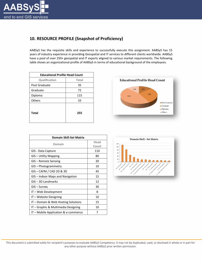
10. RESOURCE PROFILE (Snapshot of Proficiency)
AABSyS has the requisite skills and experience to successfully execute this assignment. AABSyS has 15 years of industry experience in providing Geospatial and IT services to different clients worldwide. AABSyS have a pool of over 250+ geospatial and IT experts aligned to various market requirements. The following table shows an organizational profile of AABSyS in terms of educational background of the employees.
Educational Profile Head Count
Qualification Total
Post Graduate 35
Graduate 72
Diploma 115
Others 33
Total 255
Domain Skill-Set Matrix
Domain Head Count
GIS - Data Capture 110
GIS – Utility Mapping 80
GIS – Remote Sensing 20
GIS – Photogrammetry 10
GIS – CAFM / CAD 2D & 3D 45
GIS – Indoor Maps and Navigation 15
GIS – 3D Landmarks 12
GIS – Survey 30
IT – Web Development 8
IT – Website Designing 10
IT – Domain & Web Hosting Solutions 15
IT – Graphic & Multimedia Designing 10
IT – Mobile Application & e-commerce 7

This document is submitted solely for recipient's purposes to evaluate AABSyS Competency. It may not be duplicated, used, or disclosed in whole or in part for any other purpose without AABSyS prior written permission.
11. AABSYS DIFFERENTIATORS
Cost effective outsourcing destination
Global market experience
ISO 9001:2008, ISO 14001:2004 certification
State-of-the-art infrastructure with excellent working environment
Flexible production schedules
Well trained & skilled professionals with diverse backgrounds and experiences
Short notice capacity expansions
Multilingual support: English, German, French, Hindi, Oriya, Tamil, Malayalam
Assured information Security and confidentiality

This document is submitted solely for recipient's purposes to evaluate AABSyS Competency. It may not be duplicated, used, or disclosed in whole or in part for any other purpose without AABSyS prior written permission.