abemathy to wadsworth 345 kv transmission line project
TRANSCRIPT

POWER ENGINEERS, INC. Abemathy to Wadsworth 345 kV Transmission Line Project
wholly or partially assembled on the ground, with the whole structure lifted and set in place or sections of the structure lifted and assembled into place. Monopole steel structures can be either directly embedded or installed on drilled pier concrete anchor foundations, depending on soil condition. Lattice steel structures will be installed on drilled pier concrete foundations. Once all steel structures have been erected, the process of conductor stringing will begin. This is accomplished by pulling segments of conductor, OPGW, and static wire through stringing blocks or pulleys. Once all conductors and static wires have been strung, each wire is tensioned to the required sag. The wire is then "clippecr' into conductor clamps for permanent attachment.
Construction operations will be conducted with attention to preservation of natural beauty and conservation of sensitive natural resources. The following criteria will be used to attain this goal. These criteria are subject to adjustment according to the rules and regulations of any federal, state, or local regulatory permitting agencies.
• Clearing and grading of construction areas such as storage areas, setup sites, etc., will be completed to the minimum extent necessary to ensure the safe and efficient construction of the Project.
• Excavated soils will be evenly backfilled onto a cleared area of the ROW or removed from the site. The backfilled soil will be sloped gradually to conform to the terrain and the adjacent land. If natural seeding will not provide ground cover in a reasonable length of time, appropriate reseeding will be performed.
• Erosion control devices will be constructed where necessary to reduce soil erosion in the ROW.
• Access roads will not be constructed on unstable slopes.
• Construction activities near streambeds will be performed in a manner to minimize erosion and damage to the natural condition of the area.
• Efforts will be made to prevent and remediate accidental oil spills and other types of pollution, particularly while performing work near streams, lakes, and reservoirs.
• Precautions will be taken to prevent accidental forest or range fires.
• Precautions will be taken to protect natural features and cultural resources (identified by site-specific studies of the Project) along the ROW.
• Soil disturbed during construction will be restored within a reasonable period of time.
• Sharyland will comply with any applicable permits or regulatory approvals.
1.3.6 Clean Up
Cleanup involves the restoration of disturbed areas to grade (as much as practicable), the removal of construction debris, and the restoration or compensation of any items damaged by the construction of the Project. Restoration procedures may include seeding with native grass species or the construction of permanent erosion control devices (e.g., gravel, rock) as applicable.
The following criteria generally apply to the cleanup of construction debris and the restoration of the area's natural setting. Further requirements may be imposed by public agencies that have regulatory authority over the cleanup activities and/or by private property owners under easement.
AUS 146-0259 (PER-02) SHARYLAND 150405 (2018-06-01) LD PAGE 12
300

POWER ENGINEERS, INC. Abemathy to Wadsworth 345 kV Transmission Line Project
If site factors make it unusually difficult to establish a protective vegetative cover, other restoration procedures will be used, such as the use of gravel, rocks, concrete, etc. Additionally, erosion control netting or jute mesh may be used to hold the soil and seed on slopes until growth is established. This open-weave geotextile mesh is designed to protect the soil surface from water and wind erosion while offering partial shade and heat storage to accelerate seed germination and growth.
Sears, cuts, fill, or other aesthetically degraded areas will be allowed to seed naturally or may be reseeded with native species to reduce erosion, restore a natural appearance, and provide food and cover for wildlife.
If temporary roads are removed, the original slopes will be restored.
Construction equipment, supplies, and personal property will be dismantled and removed from the ROW when construction is completed.
Clearing down to the mineral soil may be required for road access. In this case, water diversion berms, velocity dissipaters, or other erosion-control devices will be used to reduce erosion potential.
Construction waste will be removed prior to completion of the Project.
Replacement of soil adjacent to water crossing for access roads will be at slopes less than the normal angle of repose for the soil type involved and will be stabilized/re-vegetated to avoid erosion.
Sharyland will comply with any applicable permit or regulatory approval.
1.3.7 Maintenance Considerations
The following information regarding maintenance of the facilities was provided to POWER by Sharyland. Maintenance of the facilities will include periodic inspection of the transmission line and repair of damaged structures due to structural component failures, accidents, or natural phenomena such as wind or lightning damage. In areas where treatment of vegetation within the ROW is required, mowing, pruning, and/or application of USEPA-approved herbicides will be conducted as required. While maintenance patrols will vary in frequency and type, aerial, vehicular, and foot patrols will be performed periodically. In cropland areas and properly-managed grazing lands, little or no vegetation control will be required due to existing land use practices. Trimming of trees that pose a potential danger to the conductors or structures will be completed when necessary to provide a safe and reliable power line.
1.4 Agency Actions
Numerous federal, state, and local regulatory agencies have developed rules and regulations regarding the routing and potential impacts associated with the construction of proposed transmission line projects. This section describes the major regulatory agencies and additional issues that are involved in project planning and permitting. POWER solicited comments from various state, federal, and local agencies and officials during the development of this document. Records of all correspondence with agencies and officials are further summarized in Section 3.2.3 and are provided in Appendix A.
AUS 146-0259 (PER-02) SHARYLAND 150405 (2018-06-01) LD PAGE 13
301

POWER ENGINEERS, INC. Abemathy to Wadsworth 345 kV Transmission Line Project
1.4.1 Public Utility Commission of Texas
The Commission regulates the routing of transmission lines in Texas under the Public Utility Regulatory Act (PURA) § 37.056. The Commission's regulatory requirements for routing transmission lines include:
16 Texas Administrative Code (TAC) § 25.101 Procedural Rule 22.52(a)(4) Policy of prudent avoidance CCN amendment application requirements
1.4.2 United States Army Corps of Engineers
The United States Army Corps of Engineers (USACE) has jurisdiction over certain activities in or affecting waters of the United States (U.S.) under Section 10 of the Rivers and Harbors Act of 1899 (33 United States Code [U.S.C.] § 403) and Section 404 of the Clean Water Act (CWA) (33 U.S.C. § 1344). Under Section 10, the USACE regulates all work or structures in or affecting the course, condition, or capacity of navigable waters of the U.S. The intent of this law is to protect the navigable capacity of waters affecting interstate commerce. Under Section 404, the USACE regulates the discharge of dredged and fill material into all waters of the U.S., including associated wetlands. The intent of this law is to protect the nation's waters from the discharge of material capable of causing pollution and to restore and maintain the chemical, physical, and biological integrity of the nation's waters.
The Project is located within the jurisdiction of the USACE — Fort Worth and Tulsa Districts. No designated navigable waters under Section 10 were identified within the study area; therefore, no Section 10 Permit is anticipated to be necessary for construction of the Project. Streams and rivers within the study area that may be regulated under Section 404 would likely be avoided through spanning, if crossed. Playa lakes are generally considered isolated waters and are typically not regulated. Therefore, depending on the route that is selected, a Section 404 permit may not be required for this Project. If the facilities are constructed within jurisdictional areas, the construction of the project will more than likely meet the conditions of Nationwide Permit (NWP) No. 12 - Utility Line Activities. NWP 12 authorizes activities for the construction, repair, and removal of utility lines and associated facilities (i.e., substations, foundations, and access roads) in waters of the U.S. provided the general and regional conditions of the permit are met.
1.4.3 United States Fish and Wildlife Service
The USFWS is charged with the responsibility for enforcement of federal wildlife laws and providing comments on proposed construction projects with a federal nexus under the National Environmental Policy Act (NEPA) and within the framework of several other federal laws including the Endangered Species Act (ESA), Migratory Bird Treaty Act (MBTA), and the Bald and Golden Eagle Protection Act (BGEPA).
POWER reviewed the current federal species listings within the study area counties though USFWS Information for Planning and Consultation (IPaC) review process. POWER also reviewed Texas Natural Resources Diversity Database (TXNDD) records of federal and state listed species occurrences and/or sensitive/rare vegetation communities. No records of occurrence for federal listed species were identified, and no critical habitat is designated for any listed species within the study
AUS 146-0259 (PER-02) SHARYLAND 150405 (2018-06-01) LD PAGE 14
302

POWER ENGINEERS, INC. Abernathy to Wadsworth 345 kV Transmission Line Project
area. However, the lack of data does not indicate the absence of any listed species or potential habitats within the study area.
Upon Commission approval of a route and before construction, pedestrian surveys will be completed, if applicable, to identify any potential suitable habitat for federally listed species. If suitable habitat is noted, then informal consultation with the USFWS — Arlington Texas Ecological Services Field Office and West Texas Sub-office will be completed to determine the need for any required species-specific surveys and/or permitting under Section 7 or 10 of the ESA. Refer to Sections 2.5.4 and 4.4.4 for further discussion regarding threatened and endangered species and critical habitat.
1.4.4 Federal Aviation Administration
Paragraph (d) of Title 14 Code of Federal Regulations (CFR) Part 77.9 includes public-use airports listed in the Airport/Facility Directory (currently the Chart Supplement), public-use or military airports under construction, airports operated by a federal agency or Department of Defense (DoD), or an airport or heliport with at least one Federal Aviation Administration (FAA) approved instrument approach procedure. According to FAA regulations, 14 CFR Part 77.9, the construction of a transmission line requires FAA notification if a transmission tower structure height will exceed 200 feet or the height of an imaginary surface extending outward and upward at one of the following slopes:
• A 100:1 slope for a horizontal distance of 20,000 feet from the nearest point of the nearest runway of each airport described in paragraph (d) of 14 CFR Part 77.9 having at least one runway longer than 3,200 feet, excluding heliports.
• A 50:1 slope for a horizontal distance of 10,000 feet from the nearest runway of a public or military airport described in paragraph (d) of 14 CFR Part 77.9 where its longest runway is no longer than 3,200 feet in length, excluding heliports.
• A 25:1 slope for a horizontal distance of 5,000 feet for heliports described in paragraph (d) of 14 CFR Part 77.9.
Notification is not required for structures that will be shielded by existing structures of a permanent and substantial nature or by natural terrain or topographic features of equal or greater height, and that will be located in a congested area of a city, town, or settlement where the shielded structure will not adversely affect the safety of air navigation.
Following Commission approval of a route for the Project, Sharyland will make a final determination of the need for FAA notification, based on specific transmission line structure locations and design. If any of the FAA notification criteria are met for the approved route, a Notice of Proposed Construction or Alteration, FAA Form 7460-1, will be completed and submitted to the FAA Southwest Regional Office in Fort Worth, Texas at least 30 days before construction. The result of this notification and any subsequent coordination with the FAA could include changes in line design and/or potential requirements to mark and/or light the structures.
The Commission's CCN application also requires the listing private airports within 10,000 feet of any alternative route centerline.
AUS 146-0259 (PER-02) SHARYLAND 150405 (2018-06-01) LD PAGE 15
303

POWER ENGINEERS, INC. Abemathy to Wadsworth 345 kV Transmission Line Project
1.4.5 Texas Parks and Wildlife Department
The Texas Parks and Wildlife Department (TPWD) is the state agency with primary responsibility for protecting the state's fish and wildlife resources in accordance with Texas Parks and Wildlife Code Section 12.0011(b). POWER solicited comment from TPWD during the scoping phase of the Project, and a copy of this EA will be submitted to TPWD when the CCN amendment application is filed with the Commission. POWER/Sharyland have considered TPWD's recommendations during the route development phase of the Project and will further consider any additional TPWD recommendations during the construction phase.
1.4.6 Floodplain Management
Construction within floodplains may require consultation or permits from the County Floodplain Administrators. Flood Insurance Rate Maps (FIRMs), published by the Federal Emergency Management Agency (FEMA), were not available for the entire study area. Sharyland will coordinate with the local tloodplain administrators as needed to satisfy any permitting requirements before construction.
1.4.7 Texas Commission on Environmental Quality
The construction of the Project may require a Texas Pollution Discharge Elimination System General Construction Permit (TXR150000) as implemented by the Texas Commission on Environmental Quality (TCEQ) under the provisions of Section 402 of the CWA and Chapter 26 of the Texas Water Code depending on the amount of ground disturbance associated with the Project. The TCEQ has developed a three-tiered approach for implementing this permit, which is dependent on the acreage of disturbance. No permitting is required for land disturbances of less than one acre (Tier I). If more than one acre, but less than five acres are disturbed, then a Stormwater Pollution Prevention Plan (SWPPP) must be developed and implemented during construction activities accompanied with posting a Construction Site Notice and notification sent to the Municipal Separate Sewer System Operator(s) (Tier II). If more than five acres of land are disturbed, then the requirements mentioned above for Tier II are necessary and the submittal of a Notice of Intent and Notice of Termination to the TCEQ is also required (Tier III). Once a route is approved by the Commission, the proposed acreage of ground disturbance will be determined and the appropriate Tier and conditions of the TXR150000 permit will be evaluated.
1.4.8 Texas Historical Commission
Cultural resources are protected under federal law, such as Section 106 of the National Historic Preservation Act of 1966 (as amended) (NHPA), if an activity has a federal nexus (e.g., federal funding, federal permitting, or conducted on federal lands) and the activity may affect historic properties that have some level of significance under the criteria of the National Register of Historic Places (NRHP) (36 CFR Part 60). Cultural resources may also be protected under the Antiquities Code of Texas if the activity is being conducted on state land, or by a state agency or subdivision of the state on private land.
POWER contacted the Texas Historical Commission (THC) and reviewed THC and Texas Archeological Research Laboratory (TARL) records among other sources to identify previously recorded location of historical or archeological sites within the study area. POWER also estimated
AUS 146-0259 (PER-02) SHARYLAND 150405 (2018-06-0)) LD PAGE 16
304

POWER ENGINEERS, INC. Abemathy to Wadsworth 345 kV Transmission Line Project
areas of high archeological site potential. Refer to Sections 2.3 and 4.2 for further discussion regarding cultural resources.
As stated in Section 1.4.2, a USACE Section 404 permit is not anticipated for this Project; therefore, no federal permitting nexus is anticipated. As such, the NHPA will not apply to this Project. Upon Commission approval of a route, and if a federal permitting action nexus is established (e.g., a USACE Section 404/10 permit requirement), additional coordination with the lead federal permitting agency (e.g., USACE) and the State Historic Preservation Officer (SHPO) may determine the need for archeological surveys and any mitigation requirements. Although this Project is also not being conducted by a state agency, it may be located on municipal and/or state university lands depending on the route selected. Therefore, the Antiquities Code of Texas may apply and consultation with the THC may be required. Sharyland is committed to implementing the Commission's standard Final Order ordering paragraph conditions with respect to undiscovered historical/archeological resources.
1.4.9 Texas Department of Transportation
Sharyland will obtain any necessary road crossing permits from Texas Department of Transportation (TxDOT). Construction will be in accordance with the rules, regulations, and policies of TxDOT, and Best Management Practices (BMPs) will be used, as required, to minimize erosion and sedimentation resulting from the construction. Revegetation will occur as required under the "Revegetation Special Provisions" and contained in TxDOT form 1023 (Rev. 9-93). Traffic control measures will comply with applicable portions of the Texas Manual of Uniform Traffic Control Devices.
1.4.10 Texas General Land Office
The Texas General Land Office (TGLO) requires a Miscellaneous Easement for ROW across, above, or under state owned riverbeds and beds of navigable streams or tidally influenced waters. Once the Commission approves a route, Sharyland will coordinate with the TGLO as needed to determine if a Miscellaneous Easement is required.
AUS 146-0259 (PER-02) SHARYLAND 150405 (2018-06-01) LD PAGE 17
305

POWER ENGINEERS, INC. Abemathy to Wadsworth 345 kV Transmission Line Project
This page left blank intentionally
AUS 146-0259 (PER-02) SHARYLAND 150405 (2018-06-01) LD PAGE 18
306

POWER ENGINEERS, INC. Abemathy to Wadsworth 345 kV Transmission Line Project
2.0 DESCRIPTION OF THE STUDY AREA
2.1 Routing Study Methodology
The objective of this EA was to develop and evaluate an adequate number of geographically diverse alternative transmission line routes that comply with PURA § 37.056(c)(4)(A)—(D), 16 TAC § 22.52(a)(4), and 16 TAC § 25.101(b)(3)(B), including the Commission's policy of prudent avoidance. The study approach utilized by POWER for this EA included study area delineation based on the Project endpoints; identification and characterization of existing land use and environmental constraints; and identification of areas of potential routing possibilities located within the study area.
POWER identified environmental constraints, including habitable structures, and considered each sensitive resource during the route development process. POWER developed preliminary alternative route segments and considered regulatory agency, local officials, and public open-house meeting comments during the alternative route development process. Modifications, additions, or deletions of preliminary alternative segments were made while considering resource sensitivities, governmental agency guidance, and public input and comments. Feasible and geographically diverse alternative routes were then selected for analysis and comparison using evaluation criteria to determine potential impacts to existing land use and environmental resources. The EA development process culminated with the ranking of alternative routes by POWER from an environmental and land use perspective using a consensus process to recommend the alternative route that has the least potential impacts to land use and environmental resources and best meets the criteria of PURA and the Commission Substantive Rules. With this recommendation from POWER, Sharyland also considered factors including engineering and construction constraints and estimated costs to identify one alternative route that it believes best addresses the requirements of PURA and the Commission Substantive Rules. This alternative route, as well as other feasible alternative routes that provide geographic diversity and provide sufficient routing options, will be submitted to the Commission in the CCN application.
A comprehensive routing and evaluation methodology was used to develop and evaluate alternative transmission line routes. The study approach utilized by POWER included the following major tasks:
• Study area delineation.
• Identification of environmental and land use constraints and community values within the study area.
• Development of a constraints map.
• Identification of potential routing opportunities.
• Identification of preliminary alternative route segments.
• Public involvement program.
• Collection of environmental and land use data.
• Modifications to preliminary alternative route segments.
• Selection of alternative routes.
• The methodology utilized for the alternative route development process is further discussed in Section 3.0.
AUS 146-0259 (PER-02) SHARYLAND 150405 (2018-06-01) LD PAGE 19
307

POWER ENGINEERS, INC. Abemathy to Wadsworth 345 kV Transmission Line Project
This page left blank intentionally
AUS 146-0259 (PER-02) SHARYLAND 150405 (2018-06-01) LD PAGE 20
308

Abernathy Substation
Wadsworth Substation
Legend IP so II lop Study Area
Airport
t Airstrip
Heliport LUBBOCA
5
I
LOAENZO
-
SLIKON SLATON P LA- iNV I 5W
HALE '
493
A Project Substation t, Interstate Highway
tfill City Limits US Highway
,'`„0 Existing Transmission Line State Highway
c3 County Boundary FM Road
-4-*4- Railroad
FL IDYL,
Abernathy to Wadsworth 345 kV Transmission Line Project
Figure 2-1
Location of the Study Area
--+—C3--CaOSBY Miles
LY? N ,,Ak2 A ifiknt ,POWER ENGINEER
Date: 8/16/2018S
309 Path N \ ProjectsV150403_LPL_Ogallalaibemathy \ DDCIS \al:pa \Abernathy_to VVadsworthEA \ Fig_2-1_Study_Area_Loc mxcl

POWER ENGINEERS, INC. Abemathy to Wadsworth 345 kV Transmission Line Project
This page left blank intentionally
AUS 146-0259 (PER-02) SHARYLAND 150405 (2018-06-01) LD PAGE 22
310

POWER ENGINEERS, INC. Abemathy to Wadsworth 345 kV Transmission Line Project
2.1.1 Study Area Delineation
The first step in the route development process was to delineate a study area. This area needed to encompass the Project endpoints and include a sufficiently large area within which feasible and geographically diverse alternative routes could be developed. The study area, which set boundaries for the data collection process, was dictated largely by the locations of the proposed endpoints (the existing Abernathy and Wadsworth stations). The study area for the Project, as shown on Figure 2-1, extends approximately 29.5 miles north to south and 16.8 miles west to east, at its widest, and encompasses approximately 453 square miles in Hale and Lubbock counties, Texas. Major physiographic features, jurisdictional boundaries, sensitive land uses, and existing utility and roadway corridors helped to define the study area boundaries.
2.1.2 Constraints Map Development
After delineation of the study area, a constraints map was prepared and used to initially display resource data and other constraints for the Project. The constraints map provides a broad overview of various sensitive resource locations indicating obvious routing constraints and areas of potential routing opportunities.
Several methodologies were utilized to collect and review environmental and land use data, including incorporation of readily available Geographic Information System (GIS) coverage with associated metadata; review of maps and published literature; and review of files and records from numerous federal, state, and local agencies. Data collected for each resource was mapped within the study area utilizing GIS layers.
Maps and/or data layers reviewed include (but are not limited to) United States Geological Survey (USGS) 7.5-minute topographic maps, National Wetland Inventory (NWI) maps, TxDOT county highway maps, and recent aerial photography. USGS topographic maps and recent aerial photography were used as the background for the environmental and land use constraints maps.
Data typically displayed on the constraints map includes, as applicable, but is not limited to:
• Major land jurisdictions and uses.
• Major roads including local roads, county roads (CR), Farm-to-Market (FM) roads, U.S. Highways (U.S. Hwy), State Highways (SH), and Interstate Highways (IH).
• Existing transmission line and pipeline corridors.
• Airports, private airstrips, heliports, and communication facilities.
• Recreational areas, parks, and wildlife management areas.
• Major political subdivision boundaries.
• Lakes, reservoirs, rivers, streams, canals, playa lakes, and ponds.
• FEMA 100-year floodplains.
• NWI mapped wetlands.
• Mobile irrigation systems.
• Wells (including water and oil/gas).
AUS 146-0259 (PER-02) S11ARYLAND 150405 (2018-06-01) LD PAGE 23
311

POWER ENGINEERS, INC. Abemathy to Wadsworth 345 kV Transmission Line Project
2.1.3 Evaluation Criteria
Land use and environmental evaluation criteria were developed to reflect accepted practices for routing electric transmission lines in the state of Texas (Table 2-1). Emphasis was placed on acquiring information identified in PURA § 37.056(c)(4)(A)—(D), the Commission's standard CCN application, and 16 TAC § 25.101, as well as the Commission's policy of prudent avoidance. Evaluation criteria were further refined based on data collection, reconnaissance surveys, and public input. The alternative route development process was conducted with consideration and incorporation of the evaluation criteria. Evaluation criteria data were reviewed, tabulated, and compared for each resulting primary alternative route, and with other factors, were ultimately used as a basis for the recommendation of the highest ranked alternative route from an environmental and land use impact perspective (see Sections 4.0 and 5.0), and to assist Sharyland in the identification of the alternative route that best addresses the requirements of PURA and the Commission Substantive Rules.
TABLE 2-1 LAND USE AND ENVIRONMENTAL EVALUATION CRITERIA
,
Land Use
1 Length of altemative route (miles)
2 Number of habitable structures1 within 500 feet of route centerline
3 Number of newly affected habitable structures2 within 500 feet of right-of-way (ROW) centerline
4 Length of route utilizing existing electric transmission line ROW
5 Length of route parallel to existing transmission line ROW
6 Length of route parallel to other existing compatible ROW (highways, roads, railways, etc.)
7 Length of route parallel to apparent property lines3
8 Length of route parallel to pipeline ROW
9 Length of route through parks and/or recreational areas4
10 Number of parks/recreational areas4 crossed by route centerline
11 Number of additional parks/recreational areas4 within 1,000 feet of route centerline
12 Length of route through cropland not irrigated by traveling systems
13 Length of route through land iffigated by traveling systems (rolling or pivot type)
14 Length of route through pasture/rangeland (including Conservation Reserve Program lands)
15 Number of aqueduct crossings
16 Number of pipeline crossings
17 Number of transmission line crossings
18 Number of Interstate, U.S. and State Highway (IH, U.S. Hwy and SH) crossings
19 Number of farm-to-market (FM) and/or ranch-to-market (RM) road crossings
20 Number of cemeteries within 1,000 feet of the route centerline
21 Number of Federal Aviation Administration (FAA) registered airports5 with at least one runway more than 3,200 feet in length located within 20,000 feet of route centerline
22 Number of FAA registered airports5 having no runway more than 3,200 feet in length located within 10,000 feet of route centerline
23 Number of private airstrips within 10,000 feet of the route centerline
24 Number of heliports within 5,000 feet of the route centerline
AUS 146-0259 (PER-02) SHARYLAND 150405 (2018-06-01) LD
PAGE 24
312

POWER ENGINEERS, INC. Abemathy to Wadsworth 345 kV Transmission Line Project
7 7 ,
25 Number of commercial AM radio transmitters within 10,000 feet of the route centerline
26 Number of FM radio transmitters, microwave towers, and other electronic installations within 2,000 feet of route centerline
27 Number of existing water wells within 200 feet of the route centerline
28 Number of existing oil and gas wells within 200 feet of the route centerline
Aesthetics
29 Estimated length of ROW within foreground visual zone6 of IHs, U.S. Hwys and SHs
30 Estimated length of ROW within foreground visual zone6 of FM and/or RM roads
31 Estimated length of ROW within foreground visual zone6 of parks and/or recreational areas4
Ecology
32 Length of ROW through upland woodlands
33 Length of ROW through bottomland and/or riparian woodlands
34 Length of route across mapped National Wetlands Inventory (NWI) wetlands and playa lakes
35 Length of ROW across known prairie dog towns
36 Length of ROW across known habitat of federally listed endangered or threatened species
37 Length of route across open water (lakes, ponds, etc.)
38 Number of stream and/or river crossings
39 Length of ROW parallel (within 100 feet) to streams or rivers
40 Length of route across Federal Emergency Management Agency (FEMA) mapped100-year floodplains
Cultural Resources
41 Number of recorded historic or prehistoric sites crossed by route
42 Number of additional recorded historic or prehistoric sites within 1,000 feet of route centerline
43 Number of National Register of Historic Places (NRHP)-listed or -determined eligible sites crossed by route centerline
44 Number of additional NRHP-listed or -determined eligible sites within 1,000 feet of route centerline
45 Length of ROW across areas of high archeological and/or historical site potential Note. All length measurements are in miles
I Single-family and mut-family dwellings, mobile homes, apartment buildings, commercial structures, industrial structures, business structures, churches, hospitals, nursing homes, and schools, or other structures normally inhabited by humans or intended to be inhabited by humans on a daily or regular basis within 500 feet of the centerline of a transmission project greater than 230 kV
2 Newly affected habitable structures are habitable structures within 500 feet of an alternative route that are currently not already affected by an existing transmission line.
3 Apparent property lines created by existing roads, highways, or railroad ROWs are not "double-counted in the length of ROW parallel to apparent property lines criterion.
4 Defined as parks and recreational areas owned by a governmental body or an organized group, club, or church
5 As listed in the Chart Supplement South Central U.S. (FAA 2018a and FAA 2018b formerly known as the Airport/Facility Directory South Central US), and TxDOT 2018a
6 0ne-half mile, unobstructed
2.1.4 Data Collection and Constraints Mapping
Maps and data layers reviewed include, but are not limited to, USGS 7.5-minute topographic maps (Environmental Systems Research Institute [Esri] 2013), recent aerial photography (National Agriculture Imagery Program [NAIP] 2016), NWI maps, and TxDOT county highway maps. Appraisal district land parcel boundary data layers that were readily available were used to identify apparent property boundaries as paralleling possibilities. USGS 7.5-minute topographic maps (Esri
AUS 146-0259 (PER-02) SHARYLAND 150405 (2018-06-01) LD PAGE 25
313

POWER ENGINEERS, INC. Abemathy to Wadsworth 345 kV Transmission Line Project
2013) and aerial photography (NAIP 2016) were used as the background for several of the Project maps, including the initial base map, field maps, the public open-house display boards, and the environmental and land use constraints map.
To minimize potential impacts to sensitive environmental and land use resources, a constraints mapping process was used in developing and refining preliminary segments. Constraints were mapped on topographic and aerial base maps. The geographic locations of environmentally sensitive and other restrictive areas within the study area were identified and considered during preliminary segment development. Land use and environmentally sensitive areas including individual residences, congested urban areas, airports, mobile irrigation systems, cemeteries, historic sites, archeological sites, playa lakes, parks, churches, schools, and known habitat for federally listed threatened and endangered species, were mapped within the study area.
2.1.5 Agency Consultation
A list of federal, state, and local regulatory agencies, elected officials, and organizations was developed to receive a Project scoping letter. The purpose of the letter was to inform the various agencies and officials of the proposed Project and provide them with an opportunity to provide information regarding resources and potential issues within the study area. Various federal, state, and local agencies and officials that may have potential concerns and/or regulatory permitting requirements for the proposed Project were contacted. POWER utilized websites and telephone confirmations to identify local officials. Copies of all correspondence with the various state/federal regulatory agencies and local/county officials and departments are included in Appendix A.
Federal, state, and local agencies/officials contacted include:
FEDERAL
Federal Aviation Administration (FAA) Federal Emergency Management Agency (FEMA) National Park Service (NPS) Natural Resource Conservation Service (NRCS) — Texas State Office U.S. Army Corps of Engineers (USACE) — Fort Worth District U.S. Department of Defense (DoD) Siting Clearinghouse U.S. Environmental Protection Agency — Region 6 (USEPA) U.S. Fish and Wildlife Service (USFWS)
STATE
Railroad Commission of Texas (RRC) Texas Commission on Environmental Quality (TCEQ) Texas Department of Transportation (TxDOT) — Aviation Division and Environmental Affairs
Division Texas General Land Office (TGLO) Texas Historical Commission (THC) Texas Parks and Wildlife Department (TPWD) Texas Water Development Board (TWDB)
LOCAL AND OTHER ORGANIZATIONS
Abernathy Independent School District (ISD)
AUS 146-0259 (PER-02) SHARYLAND 150405 (2018-06-01) LD PAGE 26
314

POWER ENGINEERS, INC. Abemathy to Wadsworth 345 kV Transmission Line Project
City of Abernathy City of Idalou City of Lubbock City of New Deal City of Ransom Canyon City of Petersburg Hale County Commissioners Hale County Historical Commission Hale County Judge High Plains Water District Idalou ISD Lubbock County Commissioners Lubbock County Historical Commission Lubbock County Judge Lubbock International Airport Lubbock ISD National Sorghum Producers New Deal ISD Plains Cotton Growers, Inc. South Plains Association of Governments Slaton ISD Texas A&M AgriLife Research Texas Agricultural Land Trust Texas Cattle Feeders Association Texas Corn Producers Texas Farm Bureau Texas Land Conservancy Texas Land Trust Council Texas Tech University The Nature Conservancy of Texas
In addition to scoping letters sent to the agencies listed, POWER also requested and reviewed TXNDD (2018) Element Occurrence Records from TPWD. POWER requested and reviewed previously recorded archeological site information from TARL and reviewed the THC's Texas Archeological Sites Atlas (TASA) for additional cultural resource information (THC 2018a). As of the date of this document, written responses to letters sent in relation to the study area that were received are summarized in Section 3.2.3.
2.1.6 Reconnaissance Surveys
Reconnaissance surveys of the study area (conducted from publicly accessible areas) were conducted by POWER personnel to confirm the findings of research and data collection, identify changes in land use occurring after the date of aerial photography, and to identify potential unknown constraints that may not have been previously noted in the data. Reconnaissance surveys of the study area were conducted by POWER on April 3 and 4, 2018.
AUS 146-0259 (PER-02) SHARYLAND 150405 (2018-06-01) LD PAGE 27
315

POWER ENGINEERS, INC. Abemathy to Wadsworth 345 kV Transmission Line Project
2.2 Community Values
The term "community values" is included as a factor for the consideration of transmission line route approval under PURA § 37.056(c)(4)(A)—(D) of the Texas Utilities Code. The Commission's CCN application requires information concerning the following items related to community values:
• Public open house meeting.
• Approval or permits required from other governmental agencies.
• Brief description of the area traversed.
• Habitable structures within 300 feet of the centerline for transmission lines of 230 kV or less, or within 500 feet of the centerline for transmission lines of greater than 230 kV.
• Amplitude modulation (AM) radio and frequency modulation (FM) radio, microwave, and other electronic installations in the area.
• FAA registered public use airstrips, private airstrips, and heliports located in the area.
• Irrigated pasture or croplands utilizing center-pivot or other traveling irrigation systems.
• Parks and recreation areas.
• Historical and archeological sites.
In addition, POWER also evaluated the proposed Project for community values and resources that might not be specifically listed by the Commission, but that might be of importance to a particular community as a whole. The term "community values" is not formally defined in Commission rules. However, in several dockets, the following has been used as a working definition of "community values": a shared appreciation of an area or other natural resource by a national, regional, or local community. Examples of a community resource would be a park or recreational area, historical and archeological sites, or a scenic vista (aesthetics).
2.2.1 Land Use
The study area is located within the jurisdictional boundaries of Hale and Lubbock counties. The municipalities within the study area include Abernathy, Idalou, Lubbock, New Deal, Ransom Canyon, and Petersburg. Existing land uses within the study area were identified and placed into the following categories: urban/developed, planned land use, transportation features, air facilities, utility features, and communication. The primary sources of land use information were obtained from interpretation of aerial photographs, USGS topographical maps, and vehicular reconnaissance surveys from accessible public viewpoints.
Urban/Developed
Urban/Developed — The urban/developed classification represents concentrations of surface-disturbing land uses, which include habitable structures and other developed areas characterized with low, medium, and high intensities. The various levels of development include a mix of institutional, commercial, and/or industrial land uses. Developed low, medium, and high intensity areas were identified using aerial photograph interpretation and reconnaissance surveys. These classifications are defined below:
AUS 146-0259 (PER-02) SHARYLAND 150405 (2018-06-01) LD PAGE 28
316

POWER ENGINEERS, INC. Abernathy to Wadsworth 345 kV Transmission Line Project
Developed Low Intensity areas typically include rural settings with single-family housing units.
Developed Medium Intensity areas typically include single-family housing units that are grouped in residential subdivisions and might include peripheral commercial structures.
Developed High Intensity includes highly developed areas where people reside or work in high numbers. Examples include apartment complexes, row houses, and commercial/ industrial parks. Areas with the highest concentration of development are typically located within or near the towns and communities in the study area.
Most of the study area is in a rural setting except for the areas associated with the cities of Abernathy, Idalou, Lubbock, New Deal, Ransom Canyon, and Petersburg. Land use within the study area is predominantly cropland. Most of the habitable structures in the study area are associated with rural farm/ranch properties which would be considered low intensity development. Portions of the cities of Abernathy, Idalou, Lubbock, and Petersburg are composed of medium intensity residential and commercial development. No development high intensity areas are present in the study area. Habitable structures were identified using aerial photographs (Texas Orthoimagery Program [TOP] 2015; NAIP 2016), Google Earth, and reconnaissance surveys from public view points and plotted on the constraints map. The Commission's definition of a "habitable structure was used for this routing study. The Commission's CCN rule at 16 TAC § 25.101(a)(3) defines habitable structures as:
"structures normally inhabited by humans or intended to be inhabited by humans on a daily or regular basis. Habitable structures include, but are not limited to, single-family and multi-family dwellings and related structures, mobile homes, apartment buildings, commercial structures, industrial structures, business structures, churches, hospitals, nursing homes, and schools."
Agriculture
Agriculture is a significant segment of the economy throughout Texas, and both Hale and Lubbock counties have active agricultural sectors. According to the United States Department of Agriculture (USDA) National Agricultural Statistics Service's 2012 Census of Agriculture, the total market value for agricultural products sold for these counties was $584,730,000 which is an increase of 2.0 percent over the 2007 market value of $573,446,000 for both counties. Individually, the market value decreased in Lubbock County, but increased in Hale County. Livestock accounted for most of agriculture sales in Hale County, while crops sales were the majority in Lubbock County. The number of farms in the two counties of the study area decreased slightly by -6.8 percent from 2,162 in 2007 to 2,015 in 2012 (USDA 2012). Detailed agricultural information for the study area counties is provided in Table 2-2.
TABLE 2-2 AGRICULTURE
. • Xi',
r
7
/
2007 2012 Change Crop Sales
• Livestock Sales
2007 2012 Change
Hale County $364,436,000 $409,930,000 12% 32% 68% 957 899 -6% Lubbock County $209,010,000 $174,800,000 -16% 55% 45% 1,205 1,116 -7%
Source: USDA 2012
AUS 146-0259 (PER-02) SHARYLAND 150405 (2018-06-01) LD
PAGE 29
317

POWER ENGINEERS, INC. Abemathy to Wadsworth 345 kV Transmission LMe Project
Oil and Gas Facilities
Data was obtained from the RRC (2018a) which provided a GIS layer for existing oil and gas wells, pipelines, and supporting facilities. Data point categories were reviewed and included the following types: permitted locations, oil, gas, injection/disposal, shut-in, water supply, and sidetrack well surface locations. The RRC (2018a) dataset along with aerial photograph interpretation and field reconnaissance were used to identify and map existing oil and gas related facilities.
Planned Land Use
The planned land use component identifies objectives and/or policies regarding land use goals and plans, including conservation easements, managed lands, and proposed developments. Cities and counties typically prepare comprehensive land use plans to provide strategic direction by goals and objectives for the individual county. City and county websites were reviewed, and correspondence was submitted to local and county officials to identify any planned land use conflicts. None of the study area counties have comprehensive land use plans. However, the City of Lubbock does have a comprehensive plan that is used to make informed decisions on the growth, development, and revitalization of the City. The interim future land use map indicates that most of the area within the study area is zoned as public/semi-public and industrial (City of Lubbock 2018a).
Transportation. Aviation. Utility Features
Transportation Facilities
Federal, state, and local roadways were identified using TxDOT county transportation maps, Texas Natural Resource Information System (TNRIS) data, and reconnaissance surveys. The roadway transportation system within the study area includes the following major roadways: IH 27, U.S. Hwy 62, U.S. Hwy 82, SH 289, FM 40, FM 54, FM 400, FM 597, FM 789, FM 835, FM 1294, FM 1527, FM 1729, FM 2060, FM 2641, FM 2902, FM 3020, and FM 3523 (TxDOT 2018a). The roadway transportation network within the study area also includes many county and local roads.
The TxDOT's "Project Tracker," which contains detailed information by county for every project that is or could be scheduled for construction, was reviewed to identify any state roadway projects planned within the study area. The TxDOT Project Tracker indicated that there are three roadway maintenance projects scheduled for construction within the study area boundary for Hale County. There are 11 roadway maintenance projects, one roadway rehabilitation project, and one roadway safety project scheduled for construction for Lubbock County (TxDOT 2018b).
One railroad was identified within the study area, Burlington Northern Santa Fe Railroad, and one railroad spur (TxDOT 2018a). There are also two abandoned railroads identified within the study area.
Aviation
POWER reviewed the Dallas-Fort Worth Sectional Aeronautical Chart (FAA 2017) and the Chart Supplement for the South Central U.S. (formerly the Airport/Facility Directory) (FAA 2018a) to identify FAA registered facilities within the study area subject to notification requirements listed in 14 CFR Part 77.9.
The Chart Supplement for the South Central U.S. used in conjunction with the Dallas-Fort Worth Sectional Aeronautical Chart, contains all public-use airports, seaplane bases and heliports, military
AUS 146-0259 (PER-02) SHARYLAND 150405 (2018-06-01) LD PAGE 30
318

POWER ENGINEERS, INC. Abemathy to Wadsworth 345 kV Transmission Line Pnoject
facilities, and selected private-use facilities specifically requested by the DoD for which a DoD Instrument Approach Procedure has been published in the U.S. Terminal Procedures Publication.
Two public-use FAA registered airports subject to 14 CFR Part 77.9 were identified within the study area, Abernathy Municipal Airport (closed indefinitely) and Lubbock Preston Smith International Airport (FAA 2018a).
No public-use heliports or heliports with an instrument approach procedure are listed for the study area in the Chart Supplement for the South Central U.S. (FAA 2018a).
In addition, POWER reviewed the FAA database (FAA 2018b), USGS topographic maps, recent aerial photography, and conducted field reconnaissance from publicly accessible areas to identify private-use airstrips and private-use heliports not subject to notification requirements listed in 14 CFR Part 77.9. One private-use airstrip was identified within the study area. However, no private-use heliports were identified within the study area.
A Non-Directional Beacon was identified within the study area. This is a ground-based, low frequency radio transmitter used as an instrument approach for airports and offshore platforms (Southern Avionics Company 2018).
Utility Features
Utility features inventoried include existing electrical transmission lines, distribution lines, pipelines, water wells, and water tanks. Data sources used to identify existing electrical transmission and distribution lines include utility company and regional system maps, PLATTS data (PLATTS 2018), aerial imagery, USGS topographic maps, additional available planning documents, and reconnaissance surveys. The transmission lines identified within the study area include approximately twelve 69 kV transmission lines, three 115 kV transmission lines, seven 230 kV transmission lines, and three 345 kV transmission lines. Distribution lines are prevalent throughout the developed portions of the study area; however, these features are not mapped or inventoried.
In addition, several pipelines and water wells scattered throughout the study area (RRC 2018a; TWDB 2018).
Electronic Communication Facilities
Review of the Federal Communication Commission (FCC) database indicated that there are no AM radio transmitters located with the study area; however, there were 27 FM radio transmitters/ microwave towers/other electronic installations identified within the study area (FCC 2018).
Schools
The study area is located within the Abernathy ISD, New Deal ISD, Idalou ISD, Lorenzo ISD, Lubbock ISD, Lubbock-Cooper ISD, Petersburg ISD, Roosevelt ISD, and Slaton ISD. There are 14 public schools identified within the study area (Teacher Education Agency [TEA] 2018).
Conservation Easements
A conservation easement is a restriction property owners voluntarily place on specified uses of their property to protect natural, productive, or cultural features. The property owner retains legal title to the property and determines the types of uses to allow and which to restrict. The property can still be
AUS 146-0259 (PER-02) SHARYLAND 150405 (2018-06-01) LD PAGE 31
319

POWER ENGINEERS, INC. Abemathy to Wadsworth 345 kV Transmission Line Project
bought, sold, and inherited, but the conservation easement is tied to the land and binds all present and future owners to its terms and restrictions. Conservation easement language will vary as to the individual property owners allowances for additional developments on the land. The land trusts facilitate the easement and ensure compliance with the specified terms and conditions.
A review of numerous governmental and non-governmental groups (e.g., the National Conservation Easement Database [NCED], Nature Conservancy, and Texas Land Conservancy [TLC]) that are land trusts for conservation easements within Texas did not identify any conservation easements within the study area (NCED 2018; Nature Conservancy 2018; TLC 2018).
The Conservation Reserve Program (CRP) is a land conservation program offered through the USDA Farm Service Agency. This program offers a monetary incentive to farmers enrolled in the program to remove land from agricultural production and plant vegetative species that will improve environmental health and quality. Contracts for land enrolled in the CRP are generally 10 to 15 years in length. Enrollment in the CRP is a commonly known practice throughout the study area.
2.2.2 Socioeconomics
The study area covers approximately 453 square miles in Hale and Lubbock counties. This section presents a summary of economic and demographic characteristics for these counties and provides a brief description of the socioeconomic environment of the state of Texas and the study area. Literature sources reviewed include publications of the United States Bureau of the Census (USBC) and the Texas State Data Center (TSDC).
Population Trends
Hale County experienced a population decrease between 2000 and 2010 of -0.9 percent. Lubbock County experienced population growth of 15 percent over the same time. By comparison, population at the state level increased by nearly 21 percent during the same decade (USBC 2000 and 2010).
According to TSDC projections, Hale and Lubbock counties are projected to experience population growth during the next 30 years. The population increase is projected to be 35 percent in Hale County, and 31 percent in Lubbock County over the next three decades (TSDC 2014). Hale County is projected to have a population growth of 9.2 percent for 2010 to 2020, 8.5 percent for 2020 to 2030, and 6.9 percent for 2030 to 2040. Lubbock County is projected to have a population growth of 10.1 percent from 2010 to 2020, 9.7 from 2020 to 2030, and 8.3 percent from 2030 to 2040. By comparison, the population of Texas is expected to experience population increases of 15 percent, 13 percent, and 12 percent over the same time period, respectively (TSDC 2014). Table 2-3 presents the past population trends and projections for Hale and Lubbock counties and for the state of Texas.
TABLE 2-3 POPULATION TRENDS
, 2000 2010 2020 2030 2040
Texas 20,851,820 25,145,561 28,813,282 32,680,217 36,550,595 Hale County 36,602 36,273 39,596 42,963 45,912 Lubbock County 242,628 278,831 306,938 336,835 365,090
Source. USBC 2000 and 2010, TSDC 2014.
AUS 146-0259 (PER-02) SHARYLAND 150405 (2018-06-01) LD
PAGE 32
320

POWER ENGINEERS, INC. Abemathy to Wadsworth 345 kV Transmission LThe Project
Employment
From 2010 to 2016, both Hale and Lubbock counties saw an increase in the civilian labor force (CLF). Hale County saw an increase in the CLF of 3.4 percent (511 people) and Lubbock County saw an increase of 8 percent (10,762 people) over that time. By comparison, the CLF at the state level grew by 3.7 percent (5,769,625 people) over the same time period (USBC 2010 and 2016). Table 2-4 presents the CLF force for Hale and Lubbock counties and the state of Texas for the years 2010 and 2016.
Between 2010 and 2016, Hale County experienced an increase in the unemployment rate while Lubbock County experienced a decrease in the unemployment. The Hale County unemployment rate increased from 5.7 percent in 2010 to 6.5 percent in 2016. The unemployment rate in Lubbock County decreased from 6.0 percent in 2010 to 5.4 percent in 2016. By comparison, the state of Texas experienced a decrease in the unemployment rate from 2010 to 2016. The state's unemployment rate decreased from 7.9 percent in 2010 to 6.4 percent in 2016 (USBC 2010 and 2016). Table 2-4 presents the employment and unemployment data for Hale and Lubbock counties and the state of Texas for the years 2010 and 2016.
TABLE 2-4 CIVILIAN LABOR FORCE AND EMPLOYMENT
..
2010 2016 2010 2016 2010 2016 Civilian Labor Force
154,037,474 159,807,099 15,041 15,552 139,496 150,258
Employment 141,833,331 12,371,392 14,184 14,543 131,152 142,209
Unemployment 12,204,143 848,131 857 1,009 8,344 8,049 Unemployment Rate
7.9% 6.4% 5.7% 6.5% 6.0% 5.4%
Source. USBC 2010 and 2016.
Leading Economic Sectors
The major occupations for Hale County in 2016 are listed under the category of management, business, science, and arts occupations, followed by sales and office occupations (USBC 2016). The major occupations for Lubbock County in 2016 are listed under the category of management, business, science, and arts occupations, followed by sales and office occupations (USBC 2016). Table 2-5 presents the number of people employed in each occupation category during 2016 in Hale and Lubbock counties.
TABLE 2-5 OCCUPATIONS IN THE STUDY AREA COUNTIES
,
Management, business, science, and arts occupations 3,735 49,367
Service occupations 2,921 28,064
Sales and office occupations 3,106 36,364
Natural resources, construction, and maintenance occupations
2,407 14,008
Production, transportation, and material moving occupations
2,374 14,406
Source. USBC 2016.
AUS 146-0259 (PER-02) SHARYLAND 150405 (2018-06-01) LD
PAGE 33
321

POWER ENGINEERS, INC. Abemathy to Wadsworth 345 kV Transmission LMe Project
In 2010 and 2016 the industry group employing the most people in both Hale and Lubbock counties was educational services, health care, and social assistance. Table 2-6 presents the number of persons employed in each industry in Hale and Lubbock counties for the years 2010 and 2016.
TABLE 2-6 INDUSTRIES IN THE STUDY AREA COUNTIES
,
z 2010 2016 2010 2016 Agriculture, forestry, fishing and hunting, and mining 1,186 1,357 3,445 3,733 Construction 745 1,215 8,419 9,804 Manufacturing 2,047 1,471 7,777 7,414 Wholesale trade 559 381 5,150 5,154 Retail trade 1,834 1,970 16,496 18,343 Transportation and warehousing, and utilities 765 732 4,671 6,172 Information 154 79 3,644 2,693 Finance and insurance, and real estate and rental and leasing 683 702 8,087 7,728
Professional, scientific and management, and administrative and waste management services
552 676 11,741 10,573
Educational services, and health care and social assistance
2,935 3,408 35,296 41,520
Arts, entertainment, and recreation, and accommodation and food services
958 894 13,681 16,092
Other services, except public administration 888 728 7,506 7,880 Public administration 878 930 5,239 5,103
Source: USBC 2010, 2016
2.3 Recreation and Parks
The Commission recognizes parks and recreational areas as those owned by a governmental body or an organized group, club, or church. Federal and state databases searches and county/local maps were reviewed to identify any parks and/or recreational areas within the study area. Reconnaissance surveys were also conducted to identify any additional park or recreational areas.
National/State/Countv/Local Parks
No national, state, or county parks were identified within the study area (NPS 2018a; TPWD 2018a; Hale County 2018; Lubbock County 2018).
There are 12 local parks identified within the study area (City of Lubbock 2018b).
Recreational Areas
Five recreational facilities were identified within the study area. Meadowbrook Golf Course is an 18-hole golf course with two layouts.
TPWD Abernathy North Public Hunting area is located on CR 901 and is approximately 194 acres. Available game includes: doves, rabbits, and coyotes. TPWD Petersburg Public Hunting area is located on CR 275 and is approximately 231 acres. Available game includes doves, rabbits, and coyotes. TPWD Idalou Public Hunting area is located on FM 789 and is approximately 320 acres.
AUS 146-0259 (PER-02) SHARYLAND 150405 (2018-06-01) LD PAGE 34
322

POWER ENGINEERS, INC. Abemathy to Wadsworth 345 kV Transmission Line Project
The only available game are doves. TPWD Jones Farm Public Hunting area is located on CR 3550 and is approximately 177 acres. The only available game are doves (TPWD 2018b).
Additional recreational activities such as hunting and fishing may occur on private properties throughout the study area, but are not considered to be open to the public.
Wildlife Viewing Trails
Review of the TPWD Great Texas Wildlife Trails Panhandle Plains Wildlife Trail indicates that there is one wildlife viewing loop and five sites located within the study area. The Llano Estacado Loop includes the MacKenzie Park which is an urban park with open wooded savanna and thickets on the margins of the woods. The Lakes 5 and 6 (Yellowhouse Canyon) is a long lake that offers excellent photography of waterfowl and other birds. The Lubbock Cemetery stand of trees attracts a variety of bird species, particularly during migration. The Boles Road/Twin Ponds have wetland areas that attract waterfowl and has an extensive prairie dog town. The Buffalo Springs Lake is a large lake that provides extensive winter habitat for migrating birds and offers a 1.7-mile nature trail (TPWD 2018c).
2.4 Historical (Cultural Resource) and Aesthetic Values
PURA § 37.056(c)(4)(C) incorporates historical and aesthetic values as a consideration when evaluating proposed electric transmission facilities. The Commissions Standard Application for a CCN further stipulates that known historical sites within 1,000 feet of an alternative route will be listed, mapped, and their distance from the centerline of the route documented in the application. Archeological sites within 1,000 feet of a route will be listed and their distance from the centerline documented, but they need not be shown on maps for the protection of the site. Sources consulted to identify known sites (national, state, or local commission) shall also be listed.
The THC is the state agency responsible for historic preservation. The THC, working in conjunction with the TARL, maintains records of previously recorded cultural resources (archeological, architectural, and cemeteries) as well as records of previous field investigations. Information from the THC's Restricted Access TASA was reviewed and GIS shapefiles were acquired from the TARL to identify and map the locations of previously recorded cultural resource sites within 1,000 feet of the Proj ect.
Together, archeological and historical sites are often referred to as cultural resources. Under the NPS's standardized definitions, cultural resources include districts, sites, buildings, structures, or objects important to a culture, subculture, or community for scientific, traditional, religious, or other reasons. For this study, cultural resources have been divided into three major categories: archeological resources, architectural resources, and historic cemeteries. These three categories correlate to the organization of cultural resource records maintained by the THC and TARL.
• Archeological resources are locations on the ground surface or buried within the earth where human activity has measurably altered or left deposits of physical remains (e.g., burned rock middens, stone tools, petroglyphs, house foundations, and bottles). Archeological resources can date to either prehistoric times or the historic era.
• Architectural Resources typically include standing buildings (e.g., houses, barns, and outbuildings), but can also include structures (dams, canals, bridges, roads, and silos), and districts that are non-archeological in nature.
AUS 146-0259 (PER-02) SHARYLAND 150405 (2018-06-01) LD PAGE 35
323

POWER ENGINEERS, INC Abemathy to Wadsworth 345 kV Transmission Line Project
• Cemeteries are places of intentional human interment and may include large public burial grounds with multiple burials, small family plots with only a few burials, or individual grave sites. In some instances, cemeteries may be designated as Historic Texas Cemeteries (HTCs) by the THC and may be recognized with an Official Texas Historical Marker (OTHM). Other cemeteries may also be documented as part of the THC's Record, Investigate, and Protect program.
2.4.1 Cultural Background
The Project is located within portions of Hale and Lubbock counties, in the Plains Cultural Resource Planning Region as delineated by the THC (Mercado-Allinger et al. 1996) and shown in Figure 2-2. Geographically, the Project is located within Southern High Plains, along the northern edge of the Llano Estacado. This region is largely devoid of topographic relief, and what slight relief exists occurs primarily as small lake and playa basins, dunes, and dry valleys. The majority of in situ Native American archeological deposits have been recorded in association with these features. Archeologists have divided the prehistoric occupations of the region into three main periods: the Paleoindian, Archaic, and Late Prehistoric or Ceramic periods (Johnson and Holliday 2004). These, and the Historic Era, are discussed below, with most dates given as years before present (BP).
AUS 146-0259 (PER-02) SHARYLAND 150405 (2018-06-01) LD PAGE 36
324

Stitialed erE POWER ENGINEERS
Date 8/16/2018
Legend
Cultural Resource Planrung Region Boundary
County Boundary 0 30 60 120 180 240
Miles
Source Mercado- Alhnger et al , 1996
Abernathy to Wadsworth 345 kV Transmission Line Project
Figure 2-2 Location of the Study Area in
Relation to the Cultural Resource Planning Regions
of Texas
325

POWER ENGINEERS, INC. Abernathy to Wadsworth 345 kV Transmission Line Project
This page lefi blank intentionally
AUS 146-0259 (PER-02) SHARYLAND 150405 (2018-06-01) LD PAGE 38
326

POWER ENGINEERS, INC. Abemathy to Wadsworth 345 kV Transmission Line Project
Prehistory
Paleoindian (11,500 to 8, 600 BP). Evidence of human occupation in the Southern High Plains of northwestern Texas and eastern New Mexico spans at least the last 11,500 years (Johnson and Holliday 2004). The archeological complexes of the Paleoindian period are represented by the Clovis and Folsom complexes, and Late Paleoindian Period, each recognizably based on distinctive lithic technology.
The Clovis subperiod extended from approximately 11,500 to 11,000 BP during the terminal Late Pleistocene. Clovis occupation sites have been identified on the Llano Estacado, however, only three have in situ Clovis deposits; the Blackwater Draw #1 (the Clovis type-site) in New Mexico, the Miami site northeast of Amarillo, and the Lubbock Lake occupation west of Lubbock (Johnson and Holliday 2004). Each of these sites contain distinctive Clovis-type spear points found in association with mammoth remains, indicating that the Clovis population relied heavily on these animals as an important food base. At the Lubbock Lake site, at least six species of extinct megafauna were found, exhibiting evidence that the sites were used as butchering or primary kill sites (Johnson and Holliday 2004). Despite the popular misconception that these early populations were primarily hunters, evidence from the Gault Site in central Texas suggests that their diet was more generalized (Collins 2002). Clovis cultures hunted big game out of base camps for short periods of time but were highly mobile and rarely stayed for long periods at any one location.
The transition from the Clovis to Folsom subperiod (ca. 10,800 to 10,300 BP) was marked by a significant climatic and environmental change which continued into the Late Paleoindian period (Johnson and Holliday 2004). On the Southern Plains, the climate was less severe and there was a greater diversity of plant and animal species than later in the Holocene (Graham and Lundelius 1984; Guthrie 1984). Perennial streams persisted in the lower reaches of most draws. Ponds and marshes surrounded by lush vegetation began to form in the upper end of the draws. Many of the large animals hunted by Clovis populations died off as a result of the temperature fluctuation; however, large bison thrived and congregated around the ponds where food was plentiful. Folsom people took advantage of the localized food base and large bison became the mainstay of the Folsom diet (Johnson and Holliday 2004). Based on archeological assemblages at sites such as Lipscomb, Lake Theo, Lubbock Lake, and Midland/Scharbauer, Folsom groups appear to have occupied established campsites for longer periods of time than their predecessors. Many of these campsites were near the water sources frequented by bison (Johnson and Holliday 2004). Folsom points, distinct fluted projectile points similar to Clovis, but smaller and thinner on average, are diagnostic of this period.
The Late Paleoindian period (ca. 10,000 to 8,500 BP) is characterized by an intensifying of the warming and drying trend that began during the Folsom period. Plainview and Firstview points are among the diagnostic points for this period on the Southern Plains. Seasonal temperature changes became more pronounced and periodic droughts led to disappearing surface water. What water was available tended to collect in playa basins and salinas (Johnson and Holliday 2004). Despite the warming trend, subsistence strategies remained much as they were during the earlier Paleoindian Periods. Big game animals remained a large part of the diet; however, smaller mammals such as deer, rabbit, and gophers as well as fish and reptiles were also part of the diet. Archeological faunal remains dating to the Late Paleoindian vary by geography throughout Texas and represent locally available food resources (Bousman et al. 2004).
Archaic Period (8,500 to 2,000 BP). The Archaic Period in the Texas Panhandle spans the greatest length of time of any of the prehistoric periods. This 6,500-year period is divided into Early, Middle, and Late subperiods based on variations in the style of stone tools and other adaptations to the changing environment. Despite regional variations, all Archaic groups on the Southern Plains had
AUS 146-0259 (PER-02) SHARYLAND 150405 (2018-06-01) LD PAGE 39
327

POWER ENGINEERS, INC. Abemathy to Wadsworth 345 kV Transmission Line Project
seasonally varied economies; flexible group structures with periods of aggregation and dispersal; seasonally variable needs; a variety of site types resulting from diverse economic, social, and maintenance activities; and a variety of alternative strategies for coping with economic shortfalls (Hofman 1989).
Comparatively little is known about the Early Archaic subperiod (ca. 8,000 to 6,000 BP). Only two sites with Early Archaic components have been excavated in the Llano Estacado region; Lubbock Lake, and San Jon in New Mexico. These sites indicate an increased reliance on plant foods and smaller game, although bison continued to be a major part of the diet (Johnson and Holliday 2004; Dillehay 1974).
Peak aridity was reached around 6,500 BP, characterized by wind-blown sediments filling draws, landing in playas, and building dunes. Roughly coincident with the Middle Archaic, the period of peak aridity between 6,500 BP and 4,500 BP is known as the altithermal (Antevs 1955). Many of the ponds and marshes dried up and the range vegetation deteriorated. Water wells discovered at three sites dating to the Middle Archaic (Blackwater Draw Locality #1, Mustang Springs, and Marks Beach) indicate that populations were finding alternate means of procuring and storing water (Meltzer and Collins 1987). Despite the harsh conditions, archeological evidence indicates that Lubbock Lake had a relatively intensive occupation throughout the Middle Archaic. Multiple activity areas representing camping, bison kill/butchering locales, and ovens likely used for plant processing were found around the lake (Johnson and Holliday 2004).
By approximately 4,500 BP, the climate began to shift back to relatively cooler and wetter conditions marking the transition to the Late Archaic period. Range conditions improved and mixed grass prairie replaced the desert plains grasslands. Localized marshlands returned and springs once again dotted the landscape. Playas and salinas held seasonal to year-round water. The more hospitable environment supported a growing population, as evidenced by the thousands of archeological sites dating to this period, in sharp contrast to the few sites dating to the Early and Middle periods (Johnson and Holliday 2004; Hughes 1991). During the Late Archaic, the primary mode of subsistence was bison hunting, although there is evidence for smaller game and wild plants in the diet. Site types dating to the Late Archaic include campsites, rock shelters, and bison kill and butchering sites. Projectile points consisted primarily of barbed dart points which were significantly smaller than the large spear points used during the Paleoindian period (Hughes 1991).
Late Prehistoric or Ceramic Period (2,000 to 500 BP). The Late Prehistoric is marked by increased sedentism. Although hunting and gathering remained the primary mode of subsistence in the region, a hospitable environment and secure resource base allowed for a transition towards a village-gardener lifestyle. One of the hallmarks of the period was the introduction of Mogollon brownware and Woodland cord marked pottery around 1,800 BP. The bow and arrow were also introduced during this period along with small barbed arrow points and later side-notched triangular arrow points. Pit houses were common on the southern edge of the Llano Estacado early in the period, followed by a transition to surface residential structures around 800 BP. There is also some evidence of limited agriculture in the Late Prehistoric Period. Similar to the Late Archaic Period, active and abandoned stream channels continued to be preferred locations for campsites (Hughes 1991).
Three Late Prehistoric culture complexes have been recognized on the Llano Estacado: Lake Creek/Plains Woodland on the northern edge, Palo Duro on the eastern edge, and Eastern Jornada on the southwest margins. During the Late Prehistoric Period, the region was used as a north-south thoroughfare along southeasterly flowing drainages. Semi-permanent residential base camps were established at large playas and pluvial lakes along the thoroughfare.
AUS 146-0259 (PER-02) SHARYLAND 150405 (2018-06-01) LD PAGE 40
328

POWER ENGINEERS, INC. Abemathy to Wadsworth 345 kV Transmission Line Project
By the second part of the Late Prehistoric (ca. 1,000 to 800 BP), often referred to as the Village Farming Period, most of the Southern Plains were occupied by permanent semi-sedentary villages with a mixed economy based on hunting and gathering as well as horticulture (Drass 1998; Hofman and Brooks 1989). Village sites are found primarily along major stream drainages where fertile floodplain soils fostered the development of a simple gardening economy, complemented by hunting game and gathering wild plants (Brooks 1989). Brooks (1989) includes the study area within the Antelope Creek phase culture, which dates from approximately 450 to 750 BP, and includes much of the Texas and Oklahoma panhandles. Antelope Creek settlements often contain several stone slab masonry based house units forming scattered communities. The house units were arranged as single units, or compounds of multiple joined structures (Brooks 1989). Temporary camps, bison kill and processing sites, and isolated farmstead sites are also types of Antelope Creek sites. Typical arrow points include Fresno, Washita, and Harrell types, most commonly made of Alibates chert from quarries north of Amarillo. Borger Cordmarked and Stamper Cordmarked pottery types are typical of Antelope Creek sites. Intermingling of Puebloan trade pottery and Plains lithic tool types during this time indicate that trade networks were developing throughout the region (Boyd 2004). Intentional human burials were also common by this time (Boyd 2004), and generally consisted of single interments placed in a shallow pit covered with stone slabs, frequently on hilltops or mesas overlooking the village, or in trash pits, middens, or within the largest house (Brooks 1989).
Historic Period
Explorer Francisco Vasquez de Coronado crossed the northern Llano Estacado and Panhandle Plains between 1540 and 1542 AD. His expedition was undoubtedly followed by subsequent expeditions as evidenced by the glass beads trade, European-made ceramics, and metal arrow points found in archeological assemblages dating to the mid and late 1500s. Modern horse remains are also occasionally found in early historic period sites, some with evidence they had been butchered as game animals (Johnson and Holliday 2004). The introduction of the horse, European trade goods and European diseases resulted in changes in trade, mobility, and economy greater than any changes witnessed by any other comparable time period in the Southern Plains archeological record (Hofman 1989). Settlement was widely scattered, and by the mid-1800s, included aggregations of traders and soldiers, as well as trading posts, such as Adobe Walls in the Texas Panhandle (Hays et al. 1989)
Early American scouts viewed much of the land as a dry and arid; incapable of supporting life (Hämäldinen 2004). It was this misconception, coupled with the large aboriginal territories, that hindered European settlement in the area. After the Civil War, a growing and displaced, U.S. population looked to the west in search of land (Hays et al. 1989), and settlement of the Texas Southern Plains began in earnest. Among the first Europeans to arrive and settle in the Panhandle were the Pastores, or sheep men, typically of Hispanic descent from New Mexico. Numerous groups of Pastores moved onto the Llano Estacado and established small settlements consisting of local plazas surrounded by adobe houses.
The Comanche controlled the region aggressively, after pushing out the Apache in the early 1800s. After the U.S. defaulted on obligations to native tribes dictated by the Treaty of Medicine Lodge in 1867, a series of skirmishes and engagements occurred between the summer of 1874 and the spring of 1875 (Haley 2018). The U.S. government dispatched professional buffalo hunters and military troops to the Plains states to exterminate the buffalo, a primary food source of the aboriginal population, to drive the Native Americans to reservations. Professional hide hunters moved into the Texas Panhandle, and between 1872 and 1878, the great bison herds of the south were wiped, effectively eliminating a crucial component of the diet of native groups on the Southern Plains (Rister 1929). In
AUS 146-0259 (PER-02) SHARYLAND 150405 (2018-06-01) LD PAGE 41
329

POWER ENGINEERS, INC. Abemathy to Wadsworth 345 kV Transmission Line Project
retaliation, Kiowa, Comanche, Southern Cheyenne, and southern Arapaho tribes attacked a buffalo hunters camp established in territory given to the native groups in the Medicine Lodge Treaty, in what is known as the Battle of Adobe Walls (Haley 2018).
In the summer of 1874, the U.S. Army launched a major offensive against the Comanche, Kiowa, Southern Cheyenne, and Southern Arapaho on the Southern Plains to remove them from the region and relocate them onto reservations in western Oklahoma, beginning what would become known as the Red River War (Cruse 2008). Fraudulent land acquisition, illegal trafficking of stolen Indian stock, blocked rations, and the decimation of the buffalo population served as purposeful attempts to remove or annihilate the Native American population (Haley 2018). After the war ended in 1875, the Comanche population was reduced from several thousand to just under 1,600 individuals (Lipscomb 2018).
Hale and Lubbock counties were established shortly after the end of the Red River War in 1876. Hale County was organized in 1888 with Plainview as the county seat (Leffler 2018). Lubbock was formally organized in 1891, after Old Lubbock and Monterey were abandoned by their promoters and combined into one settlement, which became the Lubbock County seat (Graves 2018a).
Favorable land laws and fertile soil made Lubbock County an attractive place to settle. In 1890, thirty-three people resided in the county (Graves 2018b). By 1900, 293 people resided in the county, after a wave of farmers moved onto the plains. Sorghum cane dominated the cultivated acres in 1891, and cotton was first successfully grown in Lubbock County in 1891 (Graves 2018b). In 1890, there were 721 residents in Hale County, where life was made difficult by drought and grasshopper plagues (Leffler 2018). Many settlers purchased school lands from the state under generous terms, but natural disasters, high costs and no access to markets forced many of these settlers into cattle ranching, which was ill-suited to the small plots of land allotted under the school lands program. The Four-Sections Act of 1895 allowed the sale and lease of up to four sections of school, asylum, or public lands in most of Texas, and attracted more settlers to the region (Leffler 2018). By 1900 there were 259 farms and ranches in Hale County, and the principal crop was corn (Leffler 2018).
The arrival of railroads into the region connected farmers to distant markets. In 1907, Hale County residents raise $75,000 to incentivize the Santa Fe Railway to build railways connecting the county to surrounding communities, allowing farming to develop as an important part of the economy, although it was still dominated by ranching (Leffler 2018). Lubbock county was on its way to becoming a sparsely populated farming county until the introduction of the railroad. The Santa Fe Railway reached Lubbock in 1909, connecting the county to Plainview (Graves 2018b). Numerous railroads were constructed throughout the county during the early 1900's, connecting farmers and ranchers to larger markets. By 1910, the populations of Hale and Lubbock counties were 7,566 and 3,624, respectively (Graves 2018b; Leffler 2018).
In 1911, Hale County drilled its first motor-driven irrigation well. In 1913, the Texas Land and Development Company purchased 60,000 acres near Plainview and developed it into ready to operate farms to attract settlers. By 1920 Hale County had 1,031 farms. Both Lubbock and Hale County agricultural economies were dominated by wheat, sorghum, and corn. The poultry industry and sheep ranching were important in both counties. By the 1930s, cotton began its rise to become the dominant crop in the counties, attracting even more settlers. Cotton was planted on 98 acres in Hale County in 1910, and almost 64,900 in 1929 (Leffler 2018). Texas Technological College, now called Texas Tech University, was opened in 1925, in Lubbock, and was critical to the county's growth, which outpaced that of surrounding counties (Graves 2018b). In 1930, the Lubbock County population reached 39,104, more than 10 times its population in 1910. In contrast, Hale County's population was just over half that of Lubbock County in 1930.
AUS 146-0259 (PER-02) SHARYLAND 150405 (2018-06-01) LD PAGE 42
330

POWER ENGINEERS, INC. Abemathy to Wadsworth 345 kV Transmission Line Project
In Hale County the economy was stifled by the Great Depression. The introduction of mechanized agriculture and government crop restrictions combined with the economic downturn resulted in almost 100 farmers losing their farms in Hale County during the depression (Leffler 2018). While Lubbock County felt the effects of the Great Depression, Lubbock's growing position as the wholesale trade area for 51 counties in West Texas and eastern New Mexico, and a retail center for much of West Texas buffered the economic blows.
The economies of both counties expanded during the 1940s. In Hale County, the discovery of oil in 1946 and manufacturing drove expansion (Leffler 2018). In Lubbock County, sorghum became increasingly important to supply the growing feedlot industry. The Ogallala Aquifer, used to irrigate cotton, sorghum, and other crops, was crucial to the region's growth. Cotton farms in the region benefited from the bracero program (Graves 2018b), which imported cheap Mexican agricultural laborers until 1963 (Koestler 2018). The city of Lubbock is the dominant force in region. Lubbock County was the state's leading agribusiness center by the 1980s (Graves 2018b), while Hale County was among the state's most productive agricultural counties (Leffler 2018).
2.4.2 Records Review
The THC, working in conjunction with TARL, maintains records of previously recorded cultural resources as well as records of previous field investigations. On January 17, 2018, GIS shapefiles were acquired from TARL to identify and map the locations of previously recorded archeological and historical resources within the Study Area. Information on archeological sites and surveys was obtained from the TASA in January and February 2018. The locations of and information pertaining to State Antiquities Landmarks, NRHP properties, cemeteries, HTCs, and OTHMs within the Study Area were obtained from the Texas Historical Sites Atlas and TASA (THC 2018a and 2018b) in January and February 2018. TxDOT's historic bridges database was reviewed for bridges that are listed or determined eligible for listing on the NRHP within the Study Area. At the national level, the NRHP database (NPS 2018b) and NPS websites for National Historic Landmarks (NPS 2018c), and National Historic Trails (NPS 2018d) were reviewed as well.
No NRHP-listed properties, State Antiquities Landmarks, or NRHP-listed or -determined eligible bridges, are recorded within the study area. Forty-nine archeological sites, four historic cemeteries, three HTCs and 10 OTHMs have been recorded within study area. One archeological site, 41LU129, has been determined eligible for listing on the NRHP. The cultural resources recorded in the study area are summarized in Table 2-7 and discussed in more detail below.
TABLE 2-7 RECORDED CULTURAL RESOURCES WITHIN THE STUDY AREA
, 4
Hale 2 0 0 2 0 4
Lubbock 47 1 0 5 3 6 Source THC 2018a and 2018b
A total of 49 archeological sites are recorded within the study area (see Table 2-8). Twenty-eight of these sites are prehistoric in age; six are historic; and 13 sites have both prehistoric and historic components. No site descriptive information is available for sites 41LU114 and 41LU115. Site 41LU129 has been determined eligible for listing on the NRHP, whereas the remaining sites have not been formally evaluated by the SHPO.
AUS 146-0259 (PER-02) SHARYLAND 150405 (2018-06-01) LD
PAGE 43
331

POWER ENGINEERS, INC Abemathy to Wadsworth 345 kV Transmission Line Project
Site 41LU129 is a prehistoric campsite occupied seasonally through the Archaic, Ceramic, and Protohistoric periods. Most of the artifacts recovered from the site are debitage and hearthstones (Johnson 2010). A hearth feature yielded evidence of cooking plants, probably yucca. Debitage analysis suggests tool reshaping and maintenance was the main knapping activity, with little new tool production. Local cherts were the most common raw materials, although most formal tools were made from Edwards formation chert types (Johnson 2010).
Although they have not been formally evaluated, sites 41LU118, 41LU132, 41LU137, 41LU138, and 41LU139 are described as potentially eligible for the NRHP or for State Antiquities Landmarks (SAL) designation by the recording archeologists. Site 41LU118 was visited from the Paleoindian to Historic periods. Sixteen occupation zones, six occupation levels, nine occupation surfaces, and five hearth features were identified at the site (Johnson and Ehlers 2014). Lithic materials recovered at the site were sourced from approximately 20 miles away for Potter Member and Ogallala Formation-derived cherts, to as far away as over 300 miles away for Jemez Mountain obsidian from New Mexico. Stone tools from the site include bifaces, unifaces, hammerstones, and groundstone. Archaic points include Ellis, Esnor, and Lange. The most abundant projectile point type was Scallorn, which date to the Late Prehistoric Period. A lesser amount of Perdiz points, from the later Late Prehistoric Period, were recovered. Protohistoric and Historic points include Harrell, Fresno, and Washita types. Pottery types include El Paso Brownware and Polychrome, Chupadero Black-on-White, Jornada Brownware, and South Pecos Brownware. Beads recovered from the site indicate trade with Anglo groups in the east (Johnson and Ehlers 2014).
Artifacts recovered from 41LU137 include hearthstones, debitage, and modified bone. Although no time-diagnostic materials were recovered at the site, the strata in which most of the materials were recovered suggest the site was occupied most often from the Late Archaic to Historic period. A hearth and two bison bone beds were recorded at 41LU138. One of the bison features appears to date to the Early to Middle Archaic periods. Radiocarbon dates for the other bison bonebed suggests it is a Folsom-age bison kill. Site 41LU139 cultural materials include hearthstones, lithic material, culturally modified bones, and bones that date from the late Paleoindian through the historic periods (Johnson and Ehlers 2014).
TABLE 2-8 PREVIOUSLY RECORDED SITES WITHIN STUDY AREA
04181101" :440000TON
41HA62 Undetermined Historic Dump site with mill lumber and gravel concentrations, bottle glass, a Texas license plate, ceramics, brick, concrete, and tile fragments
41HA63 Undetermined Historic Domestic scatter with broken glass, small pieces of metal, historic ceramics, brick, milled lumber, and animal bones
41LU7 Undetermined Prehistoric Campsite with debitage, burned caliche, and ground stone fragments
41LU8 Undetermined Prehistoric Lithic scatter 41LU9 Undetermined Prehistoric Lithic scatter
41LU10 Undetermined Prehistoric Lithic scatter 41LU11 Undetermined Prehistoric Lithic scatter 41LU12 Undetermined Prehistoric Lithic scatter 41LU13 Undetermined Prehistoric Lithic scatter 41LU14 Undetermined Prehistoric Lithic scatter 41LU15 Undetermined Prehistoric Campsite with debitage and bone
41LU16 Undetermined Prehistoric Campsite with stone tools, groundstone fragments, and burned bone
AUS 146-0259 (PER-02) SHARYLAND 150405 (2018-06-01) LD
PAGE 44
332
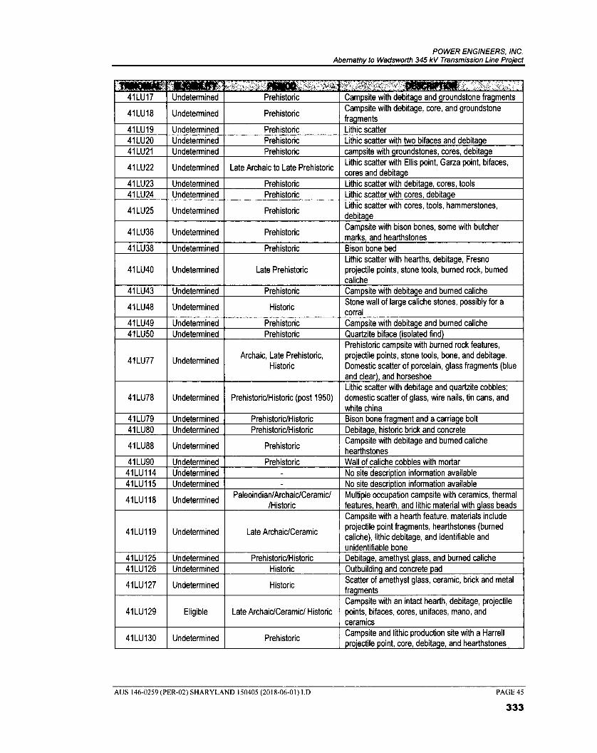
POWER ENGINEERS, INC. Abemathy to Wadsworth 345 kV Transmission Line Project
41LU17 Undetermined Prehistoric Campsite with debitage and groundstone fragments
41LU18 Undetermined Prehistoric Campsite with debitage, core, and groundstone fragments
41LU19 Undetermined Prehistoric Lithic scatter 41LU20 Undetermined Prehistoric Lithic scatter with two bifaces and debitage 41LU21 Undetermined Prehistoric campsite with groundstones, cores, debitage
41LU22 Undetermined Late Archaic to Late Prehistoric Lithic scatter with Ellis point, Garza point, bifaces, cores and debitage
41LU23 Undetermined Prehistoric Lithic scatter with debitage, cores, tools 41LU24 Undetermined Prehistoric Lithic scatter with cores, debitage
41LU25 Undetermined Prehistoric Lithic scatter with cores, tools, hammerstones, debitage
41LU36 Undetermined Prehistoric Campsite with bison bones, some with butcher marks, and hearthstones
41LU38 Undetermined Prehistoric Bison bone bed
41LU40 Undetermined Late Prehistoric Lithic scatter with hearths, debitage, Fresno projectile points, stone tools, burned rock, burned caliche
41LU43 Undetermined Prehistoric Campsite with debitage and burned caliche
41LU48 Undetermined Historic Stone wall of large caliche stones, possibly for a corral
41LU49 Undetermined Prehistoric Campsite with debitage and burned caliche 41LU50 Undetermined Prehistoric Quartzite biface (isolated find)
41LU77 Undetermined Archaic, Late Prehistoric,
Historic
Prehistoric campsite with burned rock features, projectile points, stone tools, bone, and debitage. Domestic scatter of porcelain, glass fragments (blue and clear), and horseshoe
41LU78 Undetermined Prehistoric/Historic (post 1950) Lithic scatter with debitage and quartzite cobbles; domestic scatter of glass, wire nails, tin cans, and white china
41LU79 Undetermined Prehistoric/Historic Bison bone fragment and a carriage bolt 41LU80 Undetermined Prehistoric/Historic Debitage, historic brick and concrete
41LU88 Undetermined Prehistoric Campsite with debitage and burned caliche hearthstones
41LU90 Undetermined Prehistoric Wall of caliche cobbles with mortar 41LU114 Undetermined - No site description information available 41LU115 Undetermined - No site description information available
41LU118 Undetermined Paleoindian/Archaic/Ceramic/
/Historic Multiple occupation campsite with ceramics, thermal features, hearth, and lithic material with glass beads
41LU119 Undetermined Late Archaic/Ceramic
Campsite with a hearth feature. materials include projectile point fragments, hearthstones (burned caliche), lithic debitage, and identifiable and unidentifiable bone
41LU125 Undetermined Prehistoric/Historic Debitage, amethyst glass, and burned caliche 41LU126 Undetermined Historic Outbuilding and concrete pad
41LU127 Undetermined Historic Scatter of amethyst glass, ceramic, brick and metal fragments
41LU129 Eligible Late Archaic/Ceramic/ Historic Campsite with an intact hearth, debitage, projectile points, bifaces, cores, unifaces, mano, and ceramics
41LU130 Undetermined Prehistoric Campsite and lithic production site with a Harrell projectile point, core, debitage, and hearthstones
AUS 146-0259 (PER-02) SHARYLAND 150405 (2018-06-01) LD
PAGE 45
333

POWER ENGINEERS, INC, Abemathy to Wadsworth 345 kV Transmission Line Project
Aliall401100110/Vt . - '' ,iiA000011MOIr 41LU132 Undetermined Archaic/Ceramic/Historic
Campsite with debitage, projectile points, bifaces, cores, unifaces, and hearthstone and ceramics
41LU134 Undetermined Prehistoric/Historic Campsite with lithic debitage, hearthstones, historic glass and metal
41LU135 Undetermined Archaic/Ceramic/Historic Campsite with lithic debitage, hearthstones, and culturally modified and unmodified bone
41LU137 Undetermined Late Archaic to Historic Campsite with debitage, hearthstones, and culturally modified bone
41LU138 Undetermined Paleoindian to Historic Campsite and bison kill site with debitage,
hearthstones, and culturally modified bone
41LU139 Undetermined Middle Archaic to Historic Campsite with debitage, hearthstones, and culturally modified bone
Source THC 2018b
The records review found seven previously recorded cemeteries within the study area (Table 2-9). The Becton, City of Lubbock, and Idalou cemeteries have been designated HTCs. A total of 10 OTHM have been recorded with the study area (Table 2-10). Most of the markers commemorate places that were important to the early development and success of the county. Two of the markers commemorate important military contributions of the area. The General Ranald Slidell Mackenzie marker commemorated a man who pursued and fought the Comanche and other Native groups in the Panhandle, paving the way white settlement in the area. The South Plains Air Field marker commemorates the use and expansion of the Lubbock Airport for the training of glider pilots were trained for WWII.
TABLE 2-9 CEMETERIES WITHIN THE STUDY AREA
,
HA-0001 Pearce Chapel - Strip Cemetery - Hale
HA-0002 unknown(Petersburg) - Hale
LU-0003 Becton HTC Lubbock
LU-0002 City of Lubbock HTC Lubbock
LU-0006 ldalou HTC Lubbock
LU-0007 Estacado - Lubbock CB-0010 Lorenzo - Lubbock/Crosby
Source. THC 2018a
TABLE 2-10 OTHM WITHIN STUDY AREA
3014 Lakeview School and Community - Hale 3960 Pearce Chapel - Strip Cemetery - Hale 5142 Struve Family Businesses - Hale 5518 Abernathy - Hale
12678 General Ranald Slidell Mackenzie - Lubbock 12968 City of Lubbock Cemetery - Lubbock 13497 ldalou Cemetery - Lubbock 13731 ldalou Cemetery - Lubbock 14531 Becton Cemetery - Lubbock 16427 South Plains Army Air Field - Lubbock
Source THC 2018a
AUS 146-0259 (PER-02) SHARYLAND 150405 (2018-06-01) LD
PAGE 46
334

POWER ENGINEERS, INC. Abemathy to Wadsworth 345 kV Transmission Line Project
2.4.3 Previous Investigations
Based on a review of the TASA (THC 2018b) data, 24 cultural resource surveys have been undertaken within the Study Area. These surveys were conducted in advance of proposed development and construction activities, wastewater, and sewage projects as well as in advance of a proposed animal shelter, and the relocation of the American Museum of Agriculture. Other surveys were conducted for archaeological research purposes in the area of Yellowhouse Canyon. The previous investigations are summarized in the table below (Table 2-11).
TABLE 2-11 PREVIOUS INVESTIGATIONS WITHIN THE STUDY AREA
No information available from TASA - - 1975
No information available from TASA USEPA - 1979
No information available from TASA USEPA - 1980
No information available from TASA USEPA - 1981
No information available from TASA USEPA - 1982
No information available from TASA - - 1983
No information available from TASA NPS - 1985
No information available from TASA
Texas Department of Hig s andhway
Public Transportation
(TDHPT)
- 1986
No information available from TASA TDHPT - 1987 No information available from TASA FCC - 1991
No information available from TASA Federal Highway
Administration - 1992
Archaeological Survey of a Proposed MHMR Hospital Location in Lubbock, Texas — Lubbock County (Hall 1993)
- - 1993
Archaeological Survey at Buffalo Springs Lake, Lubbock County, Texas — Lubbock County (Johnson et al. 1993)
Museum of Texas Tech University
- 1993
No information available from TASA - - 1998
Results of Survey Investigations for the Proposed Lubbock Storm Sewer in Yellowhouse Draw, Lubbock, Texas — Lubbock County (Feit and Griffith 2000)
Hicks & Company - 2000
Holocene Investigations at the Lubbock Lake Landmark. The 1991 through 2000 Work. — Lubbock County Lubbock Lake Landmark Quaternary Research Center Series Museum of Texas Tech University Lubbock, TX (Johnson 2002)
- _ 2002
AUS 146-0259 (PER-02) SHARYLAND 150405 (2018-06-01) LD
PAGE 47
335

POWER ENGINEERS, INC. Abemathy to Wadsworth 345 kV Transmission Line Project
i: ,
y , i Jones Station #1 (41LU129), A Multi-Component Rim Site Overlooking Yellowhouse Canyon on the Llano Estacado (Also Permit #2913) — Lubbock County (Johnson (ed.) 2010)
Museum of Texas Tech University
41LU129 10
Geoarchaeological Survey of the Proposed Abernathy Park, Hale County, Texas — Hale County (Boyd 2003)
Prewitt and Associates,
Austin - 2003
Archeological Survey of a Proposed Location for an Animal Shelter at Mackenzie Park, in the City of Lubbock, Lubbock County, Texas — Lubbock County (Hatfield 2009)
Prewitt and Associates, Inc.
41LU136 2009
Archaeological Survey of the Proposed New Location for the American Museum of Agriculture in Lubbock, Lubbock County, Texas — Lubbock County (Bradle 2009)
American Archaeology Group, LLC
- 2009
Explorations Along the Yellowhouse System, Southeastern Llano Estacado. The 2003, 2004, 2005, and 2010 Field Seasons (Johnson 2011)
Museum of Texas Tech University
41LU77, 41LU134, 41LU135, 41LU137, 41LU138, 41LU139
2011
Archeological Survey for the Lubbock Canyon Lakes Sanitary Sewer Interceptor Rehabilitation Project, City of Lubbock, Lubbock County, Texas — Lubbock County (Kimble et al. 2015)
ACI - 2015
Source. THC 2018b
2.4.4 Aesthetic Values
PURA § 37.056(c)(4)(C) incorporates aesthetics as a consideration when evaluating proposed electric transmission facilities. There are currently no formal guidelines provided for managing visual resources on private, state, or county owned lands. For the purposes of this study, the term aesthetics is defined by POWER to accommodate the subjective perception of natural beauty in a landscape and measure an area's scenic qualities. The visual analysis was conducted by describing the regional setting and determining the viewers sensitivity ratings. Related literature, aerial photograph interpretation, and reconnaissance surveys were used to describe the regional setting and to determine the landscape character types for the area.
Consideration of the visual environment includes a determination of aesthetic values (where the major potential effect of a project on the resource is considered visual) and recreational values (where the location of a transmission line could potentially affect the scenic enjoyment of the area). POWER considered the following aesthetic criteria that combine to give an area its aesthetic identity:
• Topographical variation (hills, valleys, etc.)
• Prominence of water in the landscape (rivers, lakes, etc.)
• Vegetation variety (woodland, meadows)
• Diversity of scenic elements
AUS 146-0259 (PER-02) SHARYLAND 150405 (2018-06-01) LD PAGE 48
336

POWER ENGINEERS, INC. Abemathy to Wadsworth 345 kV Transmission Line Project
• Degree of human development or alteration
• Overall uniqueness of the scenic environment compared with the larger region.
Most of the study area has been impacted by land improvements associated with agriculture, residential and commercial structures, roadways, and various utility corridors. Overall, the study area viewscape consists mostly of agricultural land spotted with residential/agricultural development.
No known high-quality aesthetic resources, designated views, or designated scenic roads or highways were identified within the study area. The study area is located within the 52-county Texas Plains Trail Region. The trail runs along IH 27 and has six sites of interest within the study area. The sites include American Wind Power Center, Bayer Museum of Agriculture, Buffalo Springs Lake, MacKenzie Park, Pheasant Ridge Winery, and Silent Wings Museum (THC 2018a).
A review of numerous websites did not indicate any Wild and Scenic Rivers, National Forests, National Monuments, National Historic Sites, National Historic Landmarks, National Historic Trails, or National Battlefields within the study area (National Wild and Scenic Rivers System [NWSRS] 2018; National Forest Service 2018; NPS 2018b and 2018e).
Based on these criteria, the study area exhibits an equivalent moderate degree of aesthetic quality for the region. Most of the study area maintains the impression of an urban community. Although some portions of the study area might be visually appealing, the aesthetic quality overall of the study area is not distinguishable from that of other adjacent areas within the region.
2.5 Environmental Integrity
PURA § 37.056(c)(4)(D) incorporates environmental integrity as a consideration when evaluating proposed electric transmission facilities. To assess the existing conditions within the study area, POWER reviewed information regarding physiography, soils, water resources, and ecological resources.
2.5.1 Physiography and Geology
As shown in Figure 2-3, the study area is located within the Southern High Plains area of the High Plains Physiographic Region of Texas (Bureau of Economic Geology [BEG] 1996). This region is described as flat with playa lakes and local dune fields. Elevations within the Southern High Plains region range from 2,200 feet to more than 3,800 feet above mean sea level (amsl) (BEG 1996). Elevations within the study area range between approximately 2,860 feet amsl in the canyons in the southern portions of the study area to approximately 3,400 feet amsl in the western portion.
The geology of the study area is predominantly comprised of the Quaternary-aged Blackwater Draw Formation, windblown silts (leoss) and cover sands. Secondary formations distributed throughout the study area include the Quaternary-aged playa or pond deposits, alluvium, and windblown sands and Tertiary-aged Ogallala Formation and Blanco Formation, Triassic-aged Dockum Group, Cretaceous-aged Comanche Peak Limestone, Walnut Formation, and Antlers Sand. These Tertiary, Cretaceous, and Triassic-aged formations are primarily exposed in the southern portions of the study area around the North Fork Double Mountain Fork Brazos River and Yellow House Canyon (BEG 1993; USGS 2018a).
AUS 146-0259 (PER-02) SHARYLAND 150405 (2018-06-01) LD PAGE 49
337

POWER ENGINEERS, INC. Abemathy to Wadsworth 345 kV Transmission Line Project
This page left blank intentionally
AUS 146-0259 (PER-02) SHARYLAND 150405 (2018-06-01) LD PAGE 50
338
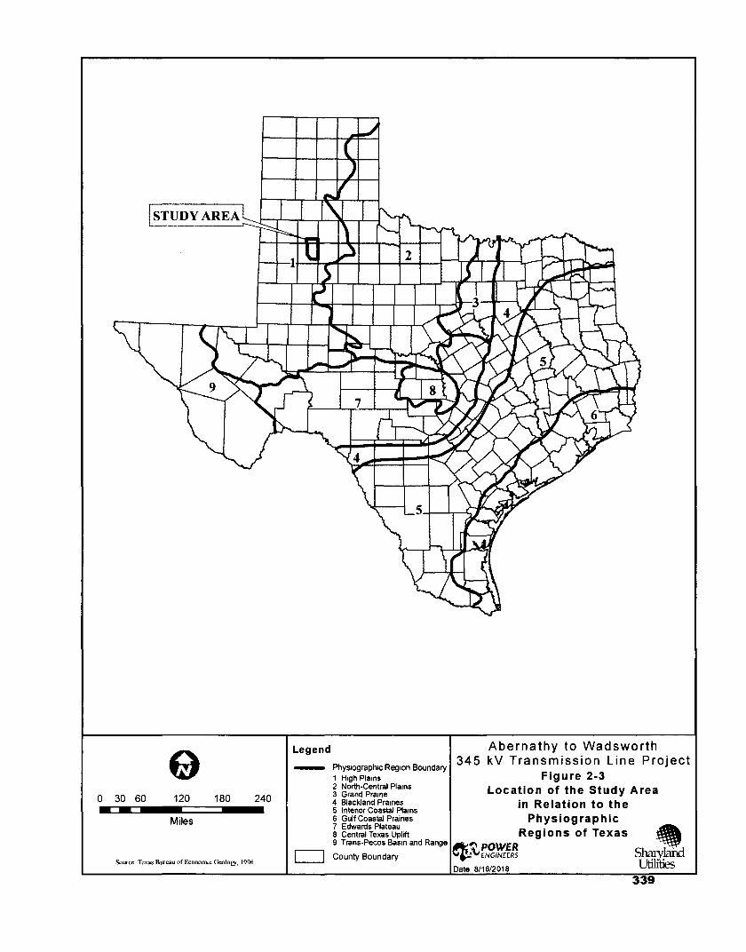
0 30 60
120 180 240
Miles
Source Texas Bureau of Econonuc Geology, 1996
Abernathy to Wadsworth 345 kV Transmission Line Project
Figure 2-3 Location of the Study Area
in Relation to the Physiographic
Regions of Texas
eV,POWER ENGINEERS Shary rand
Date 8/16/2018
Legend
Physiographic Region Boundary 1 High Plains 2 North-Central Plains 3 Grand Prairie 4 Blackland Prairies 5 lntenor Coastal Plains 6 Gulf Coastal Praines 7 Edwards Plateau 8 Central Texas Uplift 9 Trans-Pecos Basin and Range
County Boundary
339

POWER ENGINEERS, INC. Abemathy to Wadsworth 345 kV Transmission Line Project
This page left blank intentionally
AUS 146-0259 (PER-02) SHARYLAND 150405 (2018-06-01) LD PAGE 52
340

POWER ENGINEERS, INC. Abemathy to Wadsworth 345 kV Transmission Line Project
The Blackwater Draw Formation and Windblown silts (leoss) and cover sands are characterized as a grayish red fine to medium grained quartz, silt, and calcareous with caliche nodules, typically about 25 feet thick. The Ogallala Formation is exposed with alluvium deposits along larger draws and stream beds within the study area. The Ogallala Formation is described as a fluviatile sand, silt, clay, and gravel capped by caliche with a maximum thickness of 175 feet. The Blanco Formation is characterized by light greenish-gray sand quartz, clay and limestone with a thickness of 75 feet. Dockum Group occurs along the North Fork Double Mountain Fork Brazos River consists of sandstone, clay shale, and conglomerate with a thickness plus or minus 400 feet. Comanche Peak Limestone includes thin shale interbeds with marine megafossils and a thickness of around 40 feet. Walnut Formation is characterized by interbedded shale, limestone and sandstone with marine megafossils with a maximum thickness of 25 feet. Antlers Sand includes sand, sandstone, and conglomerate with a thickness around 30 feet. Alluvium occurs near streams and floodplains and consists of sedimentary floodplain deposits. Quaternary-aged playa and pond deposits are ephemeral lakes and ponds primarily comprised of clay and silt, these materials may be sandy. Windblown sand deposits typically consist of sand and silt in sheets; these may locally include dunes and rune ridges (BEG 1993; USGS 2018a).
Geological Hazards
Geologic hazards potentially affecting the construction and operation of the transmission line were evaluated within the study area. Hazardous areas reviewed included potential karst areas with known cave locations, faults, historical or current coal/uranium mining locations, gravel quarries, landfills, and potential subsurface contamination. Available data for the study area was mapped utilizing GIS.
No known caves or karst geology are known within the study area (Texas Speleological Society [TSS] 1994 and 2018). No known quaternary or seismic faults are located within the study area (BEG 1996; USGS 2018b).
No historical or current coal/uranium mining activities have occurred within the study area or region (RRC 2018a, 2018b and 2018c). One active landfill (Stericycle Inc.) is in the study area north of TX Loop 289 approximately 0.12 mile west-northwest of the intersection of N. Elder Ave. and TX Loop 289 (TCEQ 2018a). Review of USGS maps and aerial imagery identified several caliche pits and gravel pits or quarries within the study area (USGS 2018c), typically located around Yellow House Canyon. Review of the USEPA (2018a) Superfund Site and TCEQ (2018b) State Superfund Site databases did not indicate any sites within the study area.
2.5.2 Soils
Soil Associations
The Natural Resource Conservation Service (NRCS 2018) Web Soil Survey was used to identify and characterize soil associations within the study area. A soil association is a group of soils geographically associated in a characteristic repeating pattern and defined as a single unit (NRCS 2018). Soil associations occurring within the study area are listed in Table 2-12, which summarizes each soil association identified within the study area and indicates if any mapped units of the soil series within the association are considered prime farmlands and/or hydric soils (NRCS 2018).
AUS 146-0259 (PER-02) SHARYLAND 150405 (2018-06-01) LD PAGE 53
341

POWER ENGINEERS, INC. Abemathy to Wadsworth 345 kV Transmission Line Project
TABLE 2-12 MAPPED SOIL ASSOCIATIONS WITHIN THE STUDY AREA
-;
fi ' e '-
,.. ,,, ..,,, ,
$ ... At, • ti : * ' , r, ,,,,
,
Hale County, Texas
Acuff loam, 0 to 1 percent slopes Acuff (85%) Plains No Yes
Acuff loam, 1 to 3 percent slopes Acuff (85%) Playa slopes No Yes
Amarillo fine sandy loam, 0 to 1 percent slopes
Amarillo (90%) Plains No Yes
Amarillo fine sandy loam, 1 to 3 percent slopes
Amarillo (90%) Playa slopes No Yes
Arch loam, 0 to 3 percent slopes Arch (90%) Playa slopes No No
Drake clay loam, 1 to 3 percent slopes Drake (85%) Playa dunes No No
Drake soils, 3 to 8 percent slopes Drake (100%) Playa dunes No No
Estacado clay loam, 0 to 1 percent slopes
Estacado (85%)
Plains No Yes
Estacado clay loam, 1 to 3 percent slopes
Estacado (85%)
Plains, playa slopes
No Yes
Lofton clay loam, 0 to 1 percent slopes Lofton (85%) Playa steps, depressions
No Yes
Mansker loam, 3 to 5 percent slopes Mansker (85%) Playa slopes No I f i rrig a t e d
Olton clay loam, 0 to 1 percent slopes Olton (85%) Plains No Yes
Olton clay loam, 1 to 3 percent slopes Olton (100%) Plains, playa
slopes No Yes
Posey fine sandy loam, 0 to 3 percent slopes
Posey (100 %) Playa slopes No If irrigated
Posey fine sandy loam, 3 to 5 percent slopes
Posey (80%) Playa slopes No If irrigated
Pullman clay loam, 0 to 1 percent slopes Pullman (100%)
Plains No Yes
Randall clay, 0 to 1 percent slopes Randall (85%) Playa floors Yes No
Zita loam, 0 to 1 percent slopes Zita (85%) Plains No No
Zita loam, 1 to 3 percent slopes Zita (85%) Plains No No
Lubbock County, Texas
Acuff loam, 0 to 1 percent slopes Acuff (85%) Plains No Yes
Acuff loam, 1 to 3 percent slopes Acuff (85%) Plains, playa
slopes No Yes
Acuff-Urban land complex, 0 to 2 percent slopes
Acuff (55%) Plains No No
Amarillo loamy fine sand, 0 to 3 percent slopes
Amarillo (80%) Plains, playa
slopes No No
Amarillo fine sandy loam, 0 to 1 percent slopes
Amarillo (90%) Plains No Yes
Amarillo fine sandy loam, 1 to 3 percent slopes
Amarillo (90%) Playa slopes No Yes
AUS 146-0259 (PER-02) SHARYLAND 150405 (2018-06-01) LD
PAGE 54
342

POWER ENGINEERS, INC. Abemathy to Wadsworth 345 kV Transmission Line Project
..
,,'.4'
`Lf.eiliV''" 1-•
''''
' ' '' LL I
: .:4
Amarillo-Urban land complex, 0 to 2 percent slopes
Amarillo (55%) Plains No No
Arch loam, 0 to 3 percent slopes Arch (90%) Playa slopes No No
Berda loam, 1 to 3 percent slopes Berda (80%) Alluvial fans, valley
flats No No
Berda loam, 3 to 5 percent slopes Berda (80%) Alluvial fans, valley
sides No No
Berda-Potter association, hilly Berda (60%) Valley sides,
scarps No No
Bippus fine sandy loam, frequently flooded
Bippus (99%) Draws Yes No
Bippus clay loam, occasionally flooded Bippus (99%) Draws Yes Yes
Bippus clay loam, frequently flooded Bippus (99%) Draws Yes No
Drake clay loam, 1 to 3 percent slopes Drake (85%) Playa dunes No No
Drake clay loam, 3 to 5 percent slopes Drake (85%) Playa dunes No No
Estacado clay loam, 0 to 1 percent slopes
Estacado (85%)
Plains No Yes
Estacado clay loam, 1 to 3 percent slopes
Estacado (85%)
Plains, playa slopes
No Yes
Escado-Urban land complex, 0 to 2 percent slopes
Estacado (60%)
Plains No No
Friona loam, 0 to 1 percent slopes Friona (85%) Plains No If irrigated
Kimbrough loam, 0 to 3 percent slopes Kimbrough
(100%) Plains No No
Lofton clay loam, 0 to 1 percent,slopes Lofton (85%)
Depressions, a play steps
No Yes
Mansker clay loam, 1 to 3 percent slopes Mansker (85%) Draws, playa
slopes No If irrigated
Mansker clay loam, 3 to 5 percent slopes Mansker (85%) Draws,
escarpments No If irrigated
Midessa fine sandy loam, 1 to 3 percent slopes
Midessa (100%)
Plains, playa slopes
No If irrigated
Mobeetie fine sandy loam, 1 to 3 percent slopes
Mobeetie (85%)
Alluvial fans, valley floors
No No
Mobeetie fine sandy loam, 3 to 5 percent slopes
Mobeetie (80%)
Alluvial fans, valley floors & sides
No No
Mobeetie fine sandy loam, 5 to 8 percent slopes
Mobeetie (100%)
Valley sides, hillslopes
No No
Olton clay loam, 0 to 1 percent slopes Olton (85%) Plains No Yes
Olton clay loam, 1 to 3 percent slopes Olton (85%) Plains, playa
slopes No Yes
Olton-Urban land complex, 0 to 2 percent slopes
Olton (65%) Plains No No
Portales loam, 0 to 1 percent slopes Portales (85%) Interdunes, plains,
playa slopes No If irrigated
AUS 146-0259 (PER-02) SHARYLAND 150405 (2018-06-01) LD
PAGE 55
343

POWER ENGINEERS, INC. Abemathy to Wadsworth 345 kV Transmission Line Project
Posey fine sandy loam, 0 to 1 percent slopes
Posey (85%) Plains No lf irhgated
Posey fine sandy loam, 3 to 5 percent slopes
Posey (80%) Draws, playa
slopes No lf irrigated
Posey fine sandy loam, 5 to 8 percent slopes
Posey (100%) Draws No No
Potter loam, 2 to 12 percent slopes Potter (100%) Draws, scarps No No
Potter-Berda association, steep Potter (55%) Scarps, hillslopes No No
Potter-Kimbrough-Urban land complex, 1 to 5 percent slopes
Potter (50%) Draws, scarps No No
Pullman clay loam, 0 to 1 percent slopes Pullman (100%)
Plains No Yes
Randall clay, 0 to 1 percent slopes Randall (80%) Playa floors Yes No
Randall vanant fine sandy loam, occasionally ponded
Randall (95%) Playa floors Yes No
Zita fine sandy loam, 0 to 1 percent slopes
Zita (85%) Plains No No
Zita loam, 0 to 1 percent slopes Zita (85%) Plains No No Source. NRCS 2018
The most common soil types within the study area include clay-loam soils such as Pullman, Olton, and Estacado. These soils typically occur on plains and playa slopes. Soils such as Mansker, Bippus, and Posey are common on draws and slopes. Lofton, Randall, and Mobeetie are common on floodplains, depressions, and playa floors (NRCS 2018).
Prime Farmland Soils
The Secretary of Agriculture defines prime farmland soils as those soils that have the best combination of physical and chemical characteristics for producing food, feed, forage, fiber, and oilseed crops (7 U.S.C. § 4201(c)(1)(A)). Prime farmland soils have the soil quality, growing season, and moisture supply needed to economically produce sustained high yields of crops when treated and managed, including water management, according to acceptable farming methods. Additional potential prime farmlands are those soils that meet most of the requirements of prime farmland but fail because they lack the installation of water management facilities, or they lack sufficient natural moisture. The USDA would consider these soils prime farmland if such practices were instituted.
Transmission line projects are not typically subject to the requirements of the NEPA or the Farmland Protection Policy Act (FPPA) because the Project will not be completed by or receive assistance from any federal agency. The NRCS responded to POWER's solicitation for information in a letter dated April 18, 2018, that stated the following: "We consider the installation of aboveground transmission lines to be an activity of rninirnal impact that will have no effect on productive agricultural lands. Due to these reasons, the proposed activity is exempt from provisions of FPPA and no further consideration for protection is necessary" (see Appendix A).
AUS 146-0259 (PER-02) SHARYLAND 150405 (2018-06-01) LD PAGE 56
344
POWER ENGINEERS, INC Abemathy to Wadsworth 345 kV Transmission Line Project
H dric Soils
The National Technical Committee for Hydric Soils defines hydric soils as soils that were formed under conditions of saturation, flooding, or ponding long enough during the growing season to develop anaerobic conditions in the upper part. These soils, under natural conditions, are either saturated or inundated long enough during the growing season to support the growth and reproduction of hydrophytic vegetation.
Soil map units that are dominantly comprised of hydric soils might have small areas, or inclusions, of non-hydric soils in the higher positions on the landform, and map units dominantly made up of non-hydric soils might have inclusions of hydric soils in the lower positions on the landform (NRCS 2018). The soil units classified as hydric are listed in Table 2-12. Minor soils listed within soil units were not evaluated for this criterion.
2.5.3 Water Resources
Information on water resources within the study area were obtained from a variety of sources including USEPA, the National Hydrography Dataset (NHD), TWDB, aerial photography, USGS topographic maps, and field reconnaissance surveys.
Surface Waters
The study area is located entirely within the Brazos River Basin. The Brazos River Basin is the second largest basin by area in Texas and covers an area of approximately 8,732 square miles. This Basin extends from the confluence of its Salt and Double Mountain forks of the Brazos River in Stonewall County to the Gulf of Mexico. Local watersheds within the study area include the Plum Creek-North Fork Double Mountain Fork Brazos, Buffalo Springs Lake-North Fork Double Mountain Fork Brazos, Blackwater Draw, White, Middle White River, and Upper White River (USEPA 2018b).
Named linear surface waters identified within the study area include Crayfish Draw, Blackwater Draw, and the headwaters of the North Fork Double Mountain Fork Brazos River (TCEQ Segment #: 1241A). Crayfish Draw and Blackwater Draw are ephemeral drainages, primarily flowing only after heavy rainfall events. There are also playa lakes and stock ponds scattered throughout the study area. It is not uncommon that these areas may remain dry during extended droughts or during the dry season. Playa lakes are ephemeral and undergo unpredictable wet and dry cycles (USEPA 2018b; USGS 2018c). Reservoirs within the study area include Buffalo Springs Lake and Lake Ransom Canyon; both are dammed portions of the North Fork Double Mountain Fork Brazos River. Additional named surface waters within the study area include Canyon Lake Number 6, Blake Lake, Benson Lake (USEPA 2018b; USGS 2018c).
Review of the 2016 Region 0 (Llano Estacado) Water Plan and the 2017 State Water Plan identified one new surface water development within the study area (TWDB 2016 and 2017). The City of Lubbock Jim Bertram Lake 7 Project is a new reservoir planned for development along the North Fork Double Mountain Fork Brazos River, extending between FM 835 and Loop 289 (TWDB 2017). Communication with the City of Lubbock identified the approximate dam site and reservoir boundaries. This information was mapped utilizing GIS.
Under the Texas Administrative Code, the TPWD has designated Ecologically Significant Stream Segments (ESSS) based on habitat value, threatened and endangered species, species diversity and
AUS 146-0259 (PER-02) SHARYLAND 150405 (2018-06-01) LD PAGE 57
345

POWER ENGINEERS, INC. Abemathy to Wadsworth 345 kV Transmission Line Project
aesthetic value criteria (31 TAC § 357.8). No designated ESSS were located within the study area (TPWD 2018d).
In accordance with Section 303(d) and 304(a) of the CWA, the TCEQ identifies surface waters for which effluent limitations are not stringent enough to meet water quality standards and for which the associated pollutants are suitable for measurement by maximum daily load. Review of the TCEQ (2014) Texas Integrated Report of Surface Water Quality did not indicate any surface waters within the study area that do not meet these water quality standards.
Groundwater
The study area is primarily located over the Ogallala Aquifer (major). Additional minor aquifers within the study area include the Edwards-Trinity (High Plains) Aquifer in the western and southern portions. The Ogallala Aquifer is comprised of sand, gravel, clay, and silt deposits from the Tertiary Period. The Ogallala Aquifer underlies approximately 35,000 square miles of the High Plains region and provides water for 46 counties in Texas and extends though Oklahoma, Kansas and into the Dakotas. The saturated thickness of the aquifer decreases towards its southern extent and dissolved solids and chlorides increase. Groundwater drawn from the aquifer is primarily used for irrigation. The Edwards-Trinity (High Plains) Aquifer underlies about 9,000 square miles of the Ogallala Aquifer in western Texas and eastern New Mexico and typically contains more total dissolved solids than the overlaying Ogallala Aquifer and irrigation is the primary use (TWDB 2011).
Northwest portions of the study area within Hale counties may be located within the Swisher, Briscoe, and Hale County PGMA. A PGMA is a TCEQ (2018c) program to identify areas of Texas experiencing, or expected to experience, critical groundwater problems and encourage the creation of groundwater conservation districts for those areas.
The TWDB groundwater database was reviewed for public and private water wells within the study area (TWDB 2018). Additional water well data was also obtained from the High Plains Water District. Numerous public/private wells used for agricultural irrigation, domestic, stock, and industrial uses were identified throughout the study area and available data was mapped utilizing GIS (TWDB 2018). The study area counties historically contained several springs and seeps, but groundwater tables have dramatically declined due to withdrawal for agriculture irrigation. USGS (2018c) topographic maps, TWDB (2018) groundwater data, and Springs of Texas (Brune 2002) were reviewed for active spring within the study area. These data identified nine potentially active springs within the study area, all located in Yellow House Canyon along the and North Fork Double Mountain Fork Brazos River. These include Pig Squeal Springs, Buffalo Springs, Johnson Springs Tinsley Springs, and five unnamed springs.
Floodolains
FEMA floodplain mapping data were reviewed for the study area. The 100-year flood (1.0 percent flood or base flood) represents a flood event that has a 1.0 percent chance of being equaled or exceeded for any given year. FEMA 100-year floodplains within the study area are typically associated with North Fork Double Mountain Fork Brazos River, Crayfish Draw, Blackwater Draw, and playa lakes (FEMA 2018).
AUS 146-0259 (PER-02) SHARYLAND 150405 (2018-06-01) LD PAGE 58
346
POWER ENGINEERS, INC. Abemathy to Wadsworth 345 kV Transmission Line Project
2.5.4 Ecological Resources
Data and information on ecological resources within the study area were obtained from a variety of sources, including aerial photograph interpretation, field reconnaissance surveys, correspondence with the USFWS, the TPWD, and other published literature and technical reports. All biological resource data for the study area was mapped utilizing GIS.
Ecological Region
The Project is located primarily within the High Plains Level III Ecoregion with a small portion in the southeast portion of the study area located within the Southwestern Tablelands Level III Ecoregion (USEPA 2018c). Within the High Plains, the study area is primarily located within Llano Estacado Level IV Ecoregion; while portions along the southeastern boundary are located within the Caprock Canyons, Badlands, and Breaks, Level IV Ecoregion (USEPA 2018c). The High Plains Ecoregion is the southern extent of the North American Great Plains and is characterized by a relatively level plateau with numerous surface ephemeral depressional lakes (playa lakes). The Southwestern Tablelands are characterized by elevated tableland with sub-humid to semi-arid grasslands. The Llano Estacado is described as a level, treeless and elevated plain surrounded by escarpments on three sides. The geologic origin of the Llano Estacado was a layer of Miocene-Pliocene sediments (Ogallala Formation) eroded from the eastern Rocky Mountains. Several hard caliche horizons and a caprock caliche layer were developed and the caprock was covered by Pleistocene wind-borne sand and silt within the Blackwater Draw Formation. The Caprock Canyons, Badlands, and Breaks is comprised of multicolored Triassic shale and sandstone and Permian red beds with gypsum deposits exposed form the Ogallala Formation (Griffith et al. 2007).
Vegetation Types
The Project is located within the High Plains vegetational area with a small portion in the Southwest Tablelands vegetational area, as described by Gould et al. (1960) (Figure 2-4). This region is the southern extension of the North America Great Plains. Topographically, the High Plains vegetational area is a relatively level plateau characterized by shallow surface depressional playa lakes. These ephemeral playas are periodically inundated by seasonal rains and may host a wide variety of plant and animal life. Prevalent land cover types within the study area as identified by the Ecological Mapping Systems of Texas (EMST; TPWD 2018e) include Row Crops, CRP / Other Improved Grassland. A complete list of EMST modeled land cover types (subsystems) can be found in correspondence with TPWD (see Appendix A).
Fry et al. (1984) described the major vegetation types within the study area as cropland, with bands of Mesquite (Prosopis sp.)-Lotebush (Ziziphus sp.) Brush and Juniper (Juniperus sp.) within Yellow House Canyon. Localized areas of remnant shortgrass/mixed grass prairie may occur in areas that have not been converted to farmland or improved pastures. Areas marked as crops include cultivated cover crops or row crops (cotton, grain sorghum, and wheat) providing food and/or fiber for either human or domestic animal consumption. This mapped area may also include grassland areas associated with crop rotations (Frye et al. 1984). Common introduced grasses may include Johnson grass (Sorghum halepense), Bermuda grass (Cynodon dactylon), weeping lovegrass (Eragrostis curvula), barnyard grass (Echinochloa crusgalli), blue panicum (Panicum antidotale), rescue grass (Bromus unioloides), tall fescue (Festuca arundinacea), and ryegrass (Lolium perenne) (Hatch and Pluhar 1993).
AUS 146-0259 (PER-02) SHARYLAND 150405 (2018-06-01) LD PAGE 59
347

POWER ENGINEERS, INC. Abemathy to Wadsworth 345 kV Transmission Line Project
Historically, the vegetation of the High Plains region is described as predominantly mixed prairie and shortgrass prairie with tallgrass prairie occurring on deep, sandy soils Hatch et al. (1990). Typical native vegetation occurring on clay and clay loam sites include blue grama (Bouteloua gracilis), buffalograss (Buchloe dactyloides), and galleta (Hillaria jamesii), which are the principle plant species originally encountered in this region, prior to widespread agricultural development. Historically, sandy loam soils of the region supported little bluestem (Schizachyrium scoparium), western wheatgrass (Elytrigia smithii), sideoats grama (Bouteloua curtipendula), and sand dropseed (Sporobolus cryptandrus). While the High Plains area in general was characteristically treeless and brush free, today, sand sagebrush (Artemisia filifolia), western honey mesquite (Prosopis glandulosa var. torreyana), pricklypear (Opuntia spp.), and Yucca spp. have invaded many sandy and sandy loam sites (Hatch et al. 1990). Currently, most of the High Plains is in irrigated cropland. Major crops produced in the High Plains include cotton, corn, sorghum, wheat, vegetables, and sugar beets. Many of the historical playa lakes have also been converted to agricultural croplands (Hatch et al. 1990). Within the Caprock Canyons, Badlands, and Breaks ecoregion redberry junipers (Juniperus pinchotti) may grow on cliff faces and in canyons as well as Harvard oak (Quercus harvardii), honey mequite (Prosopis glandulosa), and lotebush (Ziziphus obtusifolia) (Griffith et al. 2007).
Riparian vegetation within the region may be comprised of cottonwood, elm (Ulmus spp.), hackberry, willow (Salix spp.) skunkbush sumac (Rhus aromatica), sand sagebrush, Chickasaw plum (Prunus angustifolia) shrub thickets, and mid- and tall-grass meadows. Exotic invasive species, including saltcedars and Russian olive (Elaeagnus angustifolia), have been replacing native vegetation in riparian areas (Griffith et al. 2007). Riparian areas within the study area are associated with river bottoms, draws, and fallow playa lake edges.
AUS 146-0259 (PER-02) SHARYLAND 150405 (2018-06-01) LD PAGE 60
348
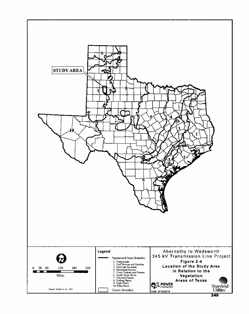
0 30 60 120 180 240
Miles
Source Gould. et al 1960
Abernathy to Wadsworth 345 kV Transmission Line Project
Figure 2-4 Location of the Study Area
in Relation to the Vegetation
Areas of Texas erty,POWER
r"ENGINEERS Shalyland Date 8/16/2018
Legend
Vegetational Areas Boundary 1 Pmeywoods 2 Gulf Praines and Marshes 3 Post Oak Savannah 4 Blackland Prairies 5 Cross Timbers and Prairies 6 South Texas Plains 7 Edwards Plateau 8 Rolling Plains 9 High Plams 10 Trans-Pecos
County Boundary
349

POWER ENGINEERS, INC. Abemathy to Wadsworth 345 kV Transmission Line Project
This page left blank intentionally
AUS 146-0259 (PER-02) SHARYLAND 150405 (2018-06-01) LD PAGE 62
350

POWER ENGINEERS, INC Abemathy to Wadsworth 345 kV Transmission Line Project
Wetlands
Mapped wetlands information was incorporated for the study area from the USFWS NWI dataset (USFWS 2018a) and are classified by Cowardin et al. (1979). Additional information on probable playa lake locations was obtained by the Playa Lakes Joint Venture (PLJV 2016). NWI maps are based on topography and interpretation of infrared satellite data and color aerial photographs. Mapped wetlands types identified within the study area typically include lakes, emergent wetlands (PEM), ponds, and forested/shrub wetlands (PSS and PFO). Dominant wetlands within the study area and are typically associated with the North Fork Double Mountain Fork Brazos River, stock ponds, and playa lakes.
Emergent wetlands are typically located along the edges and shallows of playa lakes, ponds, and streams, or other depressional areas and are comprised of such species as cattails (Typha spp.), rushes (Scirpus spp.), sedges (Carex spp.), flatsedges (Cyperus spp.), millet (Setaria spp.), spikerushes (Eleocharis spp.), smartweeds (Polygonum spp.), cocklebur (Xanthium sp.), ragweed (Ambrosia spp.) and occasionally woody species such as cottonwood and willows. Shrub/scrub wetlands are likely to be comprised of similar woody species as described for the riparian areas above (Chadde 2012a and 2012b).
Wildlife and Fisheries
The Project is located within the Kansan Biotic Province (see Figure 2-5) as described by Blair (1950). The Kansan Biotic Province includes three distinct biotic districts including the Mixed-grass Plains, the Short-grass Plains, and the Mesquite Plains. The Project is located within the Short-grass Plains District. Buffalograss and blue grama grass are the dominant short-grasses within this district (Blair 1950). The historical terrestrial wildlife community assemblage within this district was an interdependent web with dominant species including the bison (Bison bison), black-tailed prairie dog (Cynomys ludovivianus), black-footed ferret (Mustela nigripes), burrowing owl (Athene cunicularia), ferruginous hawk (Buteo regalis), coyote (Canis latrans), gray wolf (Canis lupis), swift fox (Vulpes velox), pronghorn antelope (Antilocarpa americana), deer (Odocoileus spp.), and mountain lion (Puma concolor) (Griffith et al. 2007). Many species are no longer common throughout the province due to overharvesting, eradication, loss or degradation of habitat due to conversion to croplands or grazing pastures, natural fire suppression, and barbed wire fences. Generalist species able to adapt to the conversion in habitat and land use conditions will be more commonly observed within the study area.
AUS 146-0259 (PER-02) SHARYLAND 150405 (2018-06-01) LD PAGE 63
351

POWER ENGINEERS, INC. Abernathy to Wadsworth 345 kV Transmission Line Project
This page left blank intentionally
AUS 146-0259 (PER-02) SHARYLAND 150405 (2018-06-01) LD PAGE 64
352

NAVAHONIAN
Source Blair, 1950, modified
Abernathy to Wadsworth 345 kV Transmission Line Project
Figure 2-5 Location of the Study Area
in Relation to the Biotic Provinces
of Texas
ert ,POWER ENGINEERS
Date 8/16/2018
o 0 30 60 120 180 240
Miles
Legend
Biotic Province Boundary
County Boundary
353

POWER ENGINEERS, INC. Abemathy to Wadsworth 345 kV Transmission Line Project
This page left blank intentionally
AUS 146-0259 (PER-02) SHARYLAND 150405 (2018-06-01) LD PAGE 66
354
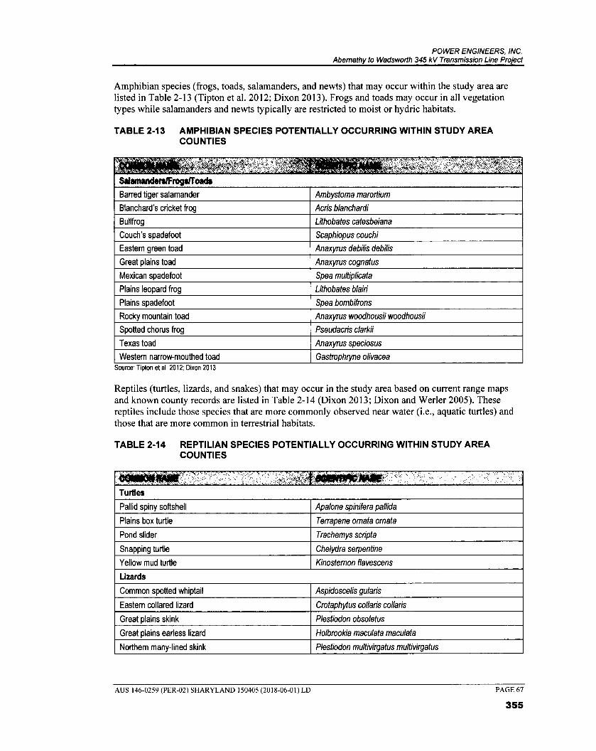
POWER ENGINEERS, INC. Abemathy to Wadsworth 345 kV Transmission Line Project
Amphibian species (frogs, toads, salamanders, and newts) that may occur within the study area are listed in Table 2-13 (Tipton et al. 2012; Dixon 2013). Frogs and toads may occur in all vegetation types while salamanders and newts typically are restricted to moist or hydric habitats.
TABLE 2-13 AMPHIBIAN SPECIES POTENTIALLY OCCURRING WITHIN STUDY AREA COUNTIES
, t Salamanders1Frogs/Toods
Barred tiger salamander Ambystoma marortium
Blanchard's cricket frog Acris blanchardi
Bullfrog Lithobates catesbeiana
Couch's spadefoot Scaphiopus couchi
Eastern green toad Anaxyrus debilis debilis
Great plains toad Anaxyrus cognatus
Mexican spadefoot Spea multiplicata
Plains leopard frog Lithobates blairi
Plains spadefoot Spea bombifrons
Rocky mountain toad Anaxyrus woodhousii woodhousii
Spotted chorus frog Pseudactis clarkii
Texas toad Anaxyrus speciosus
Western narrow-mouthed toad Gastrophtyne olivacea Source. Tipton et al 2012; Dixon 2013
Reptiles (turtles, lizards, and snakes) that may occur in the study area based on current range maps and known county records are listed in Table 2-14 (Dixon 2013; Dixon and Werler 2005). These reptiles include those species that are more commonly observed near water (i.e., aquatic turtles) and those that are more common in terrestrial habitats.
TABLE 2-14 REPTILIAN SPECIES POTENTIALLY OCCURRING WITHIN STUDY AREA COUNTIES
Turtles
Pallid spiny softshell Apalone spinifera pallida
Plains box turtle Terrapene ornata ornata
Pond slider Trachemys scripta
Snapping turtle Chelydra serpentine
Yellow mud turtle Kinostemon flavescens
Lizards
Common spotted whiptail Aspidoscelis gularis
Eastern collared lizard Crotaphytus collaris collaris
Great plains skink Plestiodon obsoletus
Great plains earless lizard Holbrookia maculata maculata
Northem many-lined skink Plestiodon multivirgatus muftivirgatus
AUS 146-0259 (PER-02) SHARYLAND 150405 (2018-06-01) LD
PAGE 67
355

POWER ENGINEERS, INC. Abemathy to Wadsworth 345 kV Transmission Line Project
Prairie lizard Sceloporus consobrinus
Prairie racerunner Aspidoscelis sexlineatus viridis
Round-tailed horned lizard Phrynosoma modestum
Slender glass lizard Ophisaurus attenuatus
Texas greater earless lizard Cophosaurus texanus texanus
Texas horned lizard Phorosoma comutum
Texas spiny lizard Sceloporus olivaceus
Snakes
Bullsnake Pituophis catenifer sayi
Central plains milksnake Lampropeltis triangulum gentilis
Checkered gartersnake Thamnophis marcianus
Chihuahuan nightsnake Hypsiglena jani
Desert kingsnake Lampropeltis getula splendida
Eastern hog-nosed snake Heterodon platirhinos
Eastern yellow-bellied racer Coluber constrictor
Flat-headed snake Tantilla gracilis
Great plains ratsnake Pantherophis emoryi emoryi
Kansas glossy snake Arizona elegans elegans
Long-nosed snake Rhinocheilus lecontei
Plain-bellied watersnake Nerodia erthrogaster
Plains black-headed snake Tantilla nigticeps nigriceps
Plains hog-nosed snake Heterodon nasicus
Prairie rattlesnake Crotalus viridis
Prairie ring-necked snake Diadophis punctatus amyi
Texas threadsnake Leptotphlops dulcis
Western coachwhip Coluber flagellum testaceus
Western diamond-backed rattlesnake Crotalus atrox
Variable groundsnake Sonora semiannulata semiannulata Source' Dixon 2013.
Numerous avian species may be present within the study area. They include year-round residents as listed in Table 2-15 (Cornell Lab of Ornithology 2017). Additional bird species may migrate within or through the study area in the spring and fall and/or use the area for nesting (spring/summer) or to overwinter. Winter migrant species that may occur in the study area are listed in Table 2-16 (Cornell Lab of Ornithology 2017). Summer migrant species that may occur in the study area are listed in Table 2-17 (Cornell Lab of Ornithology 2017; Lockwood and Freeman 2014). The likelihood for occurrence of each species will depend upon suitable habitat and the season. All migratory birds are protected under the MBTA.
AUS 146-0259 (PER-02) SHARYLAND 150405 (2018-06-01) LD PAGE 68
356
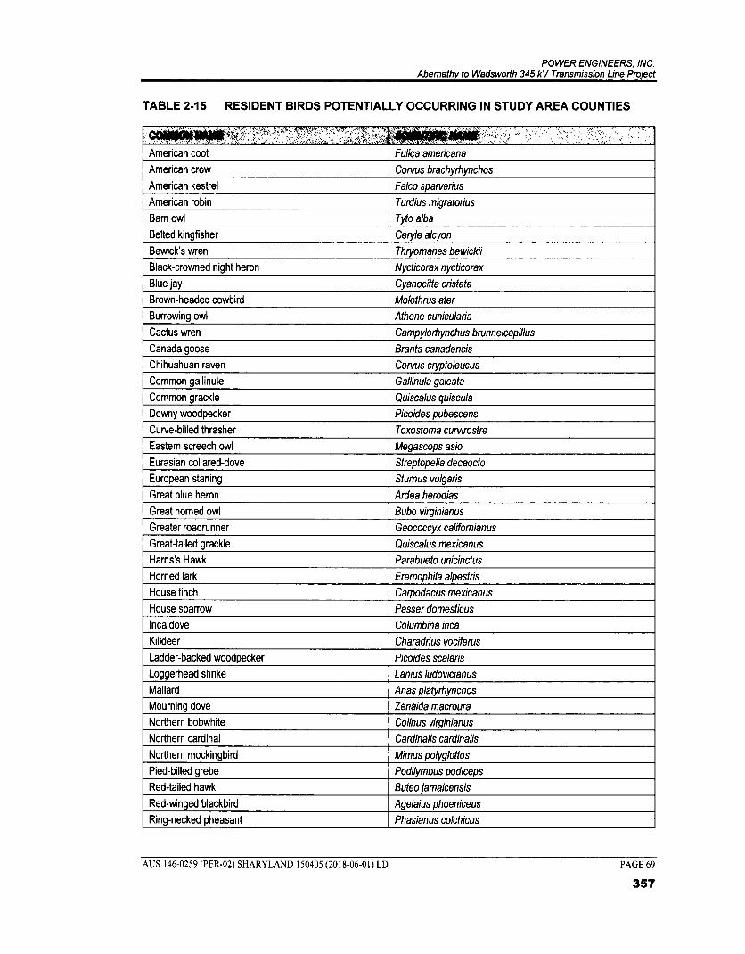
POWER ENGINEERS, INC. Abemathy to Wadsworth 345 kV Transmission Line Project
TABLE 2-15 RESIDENT BIRDS POTENTIALLY OCCURRING IN STUDY AREA COUNTIES
American coot Fulica ameticana
American crow Corvus brachyrhynchos
American kestrel Falco spatverius
American robin Turdius migratorius
Bam owl Tyto alba
Belted kingfisher Ceryle alcyon
Bewick's wren Thtyomanes bewickii
Black-crowned night heron Nycticorax nycticorax
Blue jay Cyanocitta cristata
Brown-headed cowbird Molothrus ater
Burrowing owl Athene cunicularia
Cactus wren Campylothynchus brunneicapillus
Canada goose Branta canadensis
Chihuahuan raven Corvus ctyptoleucus
Common gallinule Gallinula galeata
Common grackle Quiscalus quiscula
Downy woodpecker Picoides pubescens
Curve-billed thrasher Toxostoma cutvirostre
Eastern screech owl Megascops asio
Eurasian collared-dove Streptopelia decaocto
European starling Stumus vulgaris
Great blue heron Ardea herodias
Great horned owl Bubo virginianus
Greater roadrunner Geococcyx califomianus
Great-tailed grackle Quiscalus mexicanus
Harris's Hawk Parabueto unicinctus
Horned lark Eremophila alpestris
House finch Carpodacus mexicanus
House sparrow Passer domesticus
Inca dove Columbina inca
Killdeer Charadrius vociferus
Ladder-backed woodpecker Picoides scalaris
Loggerhead shrike Lanius ludovicianus
Mallard Anas platythynchos
Mouming dove Zenaida macroura
Northern bobwhite Colinus virginianus
Northern cardinal Cardinalis cardinalis
Northern mockingbird Mimus polyglottos
Pied-billed grebe Podilymbus podiceps
Red-tailed hawk Buteo jamaicensis
Red-winged blackbird Agelaius phoeniceus
Ring-necked pheasant Phasianus colchicus
AUS 146-0259 (PER-02) SHARYLAND 150405 (2018-06-01) LD
PAGE 69
357

POWER ENGINEERS, INC. Abemathy to Wadsworth 345 kV Transmission Line Project
Rock pigeon Columba livia
Rock wren Salpinctes obsoletus
Rufous-crowned sparrow Aimophila ruficeps
Scaled quail Callipepla squamata
Verdin Aunparus fiaviceps
Westem meadowlark Stumella neglecta
White-winged dove Zenaida asistica
Wild turkey Meleagris gallopavo Source: ComeII Lab of Omithology 2017; Lockwood and Freeman 2014.
TABLE 2-16 MIGRANT WINTER RESIDENT BIRDS POTENTIALLY OCCURRING IN STUDY AREA COUNTIES
American goldfinch Carduelis tristis
American pipit Anthus rubescens
American white pelican Pelecanus etythrorhychos
American wigeon Anas americana
Bald eagle Haliaeetus leucocephalus
Brown creeper Certhia americana
Bufflehead Bucephala albeola
Cackling goose Brenta hutchinsii
Canvasback Aythya valisineria
Cedar waxwing Bombycilla cedrorum
Chestnut-collared longspur Calcarius omatus
Chipping sparrow Spizella passerina
Clark's grebe Aechmophorus clarkii
Common goldeneye Bucephala clangula
Common loon Gavia immer
Common merganser Mergus merganser
Cooper's hawk Accipiter cooperii
Dark-eyed junco Junco hyemalis
Double-crested cormorant Phalacrocorax auritus
Eared grebe Podiceps nigricollis
Eastern bluebird Sialia sialis
Eastern meadowlark Stumella magna
Ferruginous hawk Buteo regalis
Field sparrow Spizella pusilla
Gadwall Anas strepera
Golden eagle Aquila chrysaetos
Golden-crowned kinglet Regulus satrapa
Greater scaup Aythya marila
Green-tailed towhee Pipilo chlorus
Green-winged teal Anas crecca
Hermit thrush Catharus guttatus
AUS 146-0259 (PER-02) SHARYLAND 150405 (2018-06-01) LD
PAGE 70
358

POWER ENGINEERS, INC. Abemathy to Wadsworth 345 kV Transmission Line Project
,COOTOONANE /„' .,..-,N4-7-`
HeMng gull Larus argentatus
Hooded merganser Lophodytes cucullatus
Homed grebe Podiceps auritus
House wren Troglodytes aedon
Lapland larkspur Calcarius lapponicus
Least sandpiper Calidris minutilla
Lesser scaup Aythya affinis
Lincoln's sparrow Melospiza lincolnii
Long-eared owl Asio otus
Marsh wren Cistothorus palustris
McCown's longspur Calcarius Mccownii
Merlin Falco columbaris
Mountain bluebird Sialia currucoides
Northern harrier Circus cyaneus
Northern pintail Anas acuta
Northern shoveler Pinas clypeata
Pine siskin Carduelis pinus
Prairie falcon Falco mexicanus
Pyrrhuloxia Cardinalis sinuatus
Red-breasted nuthatch Siffa canadensis
Red-naped sapsucker Sphyrapicus nuchalis
Redhead Aythya americana
Ring-billed gull Larus delawarensis
Ring-necked duck Aythya collaris
Ross goose Chen rossii
Rough-legged hawk Buteo lagopus
Ruby-crowned kinglet Regulus calendula
Ruddy duck Oxyura jamaicensis
Sandhill crane Grus canadensis
Savannah sparrow Passerculus sandwichensis
Sharp-shinned hawk Accipiter striatus
Short-eared owl Asio flammeus
Snow goose Chen caerulescens
Song sparrow Melospiza melodia
Sora Porzana carolina
Spotted towhee Pipilo maculatus
Swamp sparrow Melospiza georgiana
Vesper sparrow Pooecetes gramineus
Western grebe Aechmophorus occidentalis
White-breasted nuthatch Sitta carolinensis
White-crowned sparrow Zonotrichia leucophrys
White-throated sparrow Zonotrichia albicollis
Wilson's snipe Gallinago delicata
Wood duck Aix sponsa
AUS 146-0259 (PER-02) SHARYLAND 150405 (2018-06-01) LD
PAGE 71
359

POWER ENGINEERS, INC. Abemathy to Wadsworth 345 kV Transmission Line Project
Yellow-bellied sapsucker Sphyrapicus varius
Yellow-rumped warbler Dendroica coronata Source: ComeII Lab of Omithology 2017, Lockwood and Freeman 2014.
TABLE 2-17 MIGRANT SUMMER RESIDENT BIRDS POTENTIALLY OCCURRING IN STUDY AREA COUNTIES
American avocet Recurvirostra americana
Ash-throated flycatcher Myiarchus cinerascens
Bam swallow Hirundo nrstica
Black-chinned hummingbird Archilochus alexandri
Black-necked stilt Himantopus mexicanus
Blue grosbeak Passerina caerulea
Blue-winged teal Anas discors
Bronzed cowbird Molothrus aeneus
Bullock's oriole lcterus bullockii
Cassin's sparrow Aimophila cassinii
Cattle egret Bubulcus ibis
Cave swallow Petrochelidon fulva
Chimney swift Chaetura pelagica
Cinnamon teal Anas cyanpterra
Cliff swallow Petrochelidon pyrrhonota
Common nighthawk Chordeiles minor
Common poorwill Phalaenoptilus nuttallii
Dickcissel Spiza americana
Grasshopper sparrow Ammodramus savannarum
Green heron Butorides virescens
Lark bunting Calamospiza melanocorys
Lark sparrow Chondestes grammacus
Lesser goldfinch Spinus psaltria
Mississippi kite lctinia mississippiensis
Northem Flicker Colaptes auratus
Northem rough-winged swallow Stelgidopteryx serripennis
Orchard oriole lcterus spurius
Painted bunting Passerina ciris
Purple martin Progne subis
Says phoebe Sayomis saya
Scissor-tailed flycatcher Tyrannus forticatus
Swainson's hawk Buteo swainoni
Turkey vulture Cathartes aura
Western kingbird Tyrannus verticalis
Yellow-crowned night heron Nyctanassa violacea
Yellow-billed cuckoo Coccyzus americanus Source: ComeII Lab of Omithology 2017; Lockwood and Freeman 2014
AUS 146-0259 (PER-02) SHARYLAND 150405 (2018-06-01) LD
PAGE 72
360

POWER ENGINEERS, INC. Abemathy to Wadsworth 345 kV Transmission Line Project
Mammals that may potentially occur in the study area based on current range maps and known county records are listed in Table 2-18 (Schmidly and Bradley 2016). The occurrence of each species will be dependent on suitable habitat available with some species migrating through the study area.
TABLE 2-18 MAMMALIAN SPECIES POTENTIALLY OCCURRING WITHIN STUDY AREA COUNTIES
41014010KINEIVT7g?1:77 ,,t,141,-"WSMIONONMOINV/4„;,,IMUA':i.':; #
Amehcan badger Taxidea taxus
American parastrelle Parastrellus hesperus
American perimyotis Perimyotis subflavus
Banner-tailed kangaroo rat Dipodomys spectabilis
Big brown bat Eptesicus fuscus
Big free-tailed bat Nyctinomops macrotis
Black rat Rattus rattus
Black-tailed jackrabbit Lepus califomicus
Black-tailed prairie dog Cynomys ludovicianus
Bobcat Lynx rufus
Brazilian free-tailed bat Tadarida brasiliensis
Cave myotis bat Myotis velifer
Common gray fox Urocyon cinereoargenteus
Coyote Canis latrans
Desert cottontail rabbit Sylvilagus audubonii
Desert shrew Notiosorex crawfordi
Deer mouse Peromyscus maniculatus
Eastern cottontail rabbit Sylvilagus floridanus
Eastern gray squirrel Sciurus carolinensis
Eastern fox squirrel Sciurus niger
Eastern red bat Lasiurus borealis
Eastem spotted skunk Spilogale putorius
Feral pig Sus scrofa
Hispid cotton rat Sigmodon hispidus
Hispid pocket mouse Chaetodipus hispidus
Hoary bat Lasiurus cinereus
Hog-nosed skunk Conepatus leuconotus
House mouse Mus musculus
Least shrew Cryptotis parva
Long-tailed weasel Mustela frenata
Merriam's pocket mouse Perognathus merriami
Mule deer Odocoileus hemionus
Nine-banded armadillo Dasypus novemcinctus
Northern grasshopper mouse Onychomys leucogaster
Northern pygmy mouse Baiomys taylori
Norway rat Rattus norvegicus
Ord's kangaroo rat Dipodomys ordii
Plains harvest mouse Reithrodontomys montanus
Plains pocket gopher Geomys bursarius
Plains pocket mouse Perognathus flavescens
AUS 146-0259 (PER-02) SHARYLAND 150405 (2018-06-01) LD
PAGE 73
361
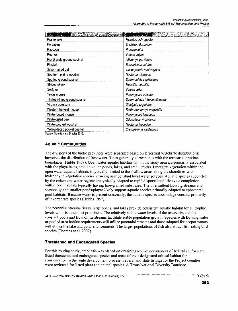
POWER ENGINEERS, INC. Abemathy to Wadsworth 345 kV Transmission Line Project
, . .
Prairie vole Microtus ochrogaster
Porcupine Erethizon dorsatum
Raccoon Procyon /otor
Red fox Vulpes vulpes
Rio Grande ground squirrel lctidomys panridens
Ringtail Bassariscus astutus
Silver-haired bat Lasionycteris noctivagans
Southem plains woodrat Neotoma micropus
Spotted ground squirrel Spermophilus spilosoma
Striped skunk Mephitis mephitis
Swift fox Vulpes velox
Texas mouse Peromyscus attwateri
Thirteen-lined ground squirrel Spermophilus tridecemlineatus
Virginia opossum Didelphis virginiana
Western harvest mouse Reithrodontomys megalotis
White-footed mouse Peromyscus leucopus
White-tailed deer Odocoileus virginianus
White-toothed woodrat Neotoma leucodon
Yellow-faced pocket gopher Cratogeomys castanops Source. Schmidly and Bradley 2016.
Aquatic Communities
The divisions of the biotic provinces were separated based on terrestrial vertebrate distributions; however, the distribution of freshwater fishes generally corresponds with the terrestrial province boundaries (Hubbs 1957). Open water aquatic habitats within the study area are primarily associated with the playa lakes, small alkaline ponds, lakes, and small creeks. Emergent vegetation within the open water aquatic habitats is typically limited to the shallow areas along the shorelines with hydrophytic vegetative species growing near constant level water sources. Aquatic species supported by the ephemeral water regime are typically adapted to rapid dispersal and life cycle completion within pool habitats typically having fine-grained substrates. The intermittent flowing streams and seasonally and smaller ponds/playas likely support aquatic species primarily adapted to ephemeral pool habitats. Because water is present seasonally, the aquatic species assemblage consists primarily of invertebrate species (Hubbs 1957).
The perennial streams/rivers, large ponds, and lakes provide consistent aquatic habitat for all trophic levels with fish the most prominent. The relatively stable water levels of the reservoirs and the constant pools and flow of the streams facilitate stable population growth. Species with flowing water or pooled area habitat requirements will utilize perennial streams and those adapted for deeper waters will utilize the lake and pond environments. The larger populations of fish also attract fish eating bird species (Thomas et al. 2007).
Threatened and Endarmered Species
For this routing study, emphasis was placed on obtaining known occurrences of federal and/or state listed threatened and endangered species and areas of their designated critical habitat for consideration in the route development process. Federal and state listings for the Project counties were reviewed for listed plant and animal species. A Texas National Diversity Database
AUS 146-0259 (PER-02) SHARYLAND 150405 (2018-06-01) LD PAGE 74
362
POWER ENGINEERS, INC. Abemathy to Wadsworth 345 kV Transmission Line Project
(TXNDD 2018) report for occurrences of these species within the study area was also reviewed to determine the potential for occurrence within the study area.
A USFWS (2018b) IPaC (Consultation Code: 02ETAR00-2018-SLI-0995) Resource List was requested and received on May 09, 2018. This USFWS report identifies potentially occurring federal-listed threatened, endangered, and candidate species and habitats within the study area (USFWS 2018b). By definition under the ESA, a threatened species is as likely to become endangered within the near foreseeable future throughout all or a significant portion of its range. An endangered species is in danger of extinction throughout all or a significant portion of its range. Candidate species are those that have sufficient information on their biological vulnerability and threat(s) to support listing as threatened or endangered and are likely to be proposed for listing in the near foreseeable future. The ESA also provides for the conservation of "designated critical habitat," which is defined as the areas of land, water, and air space that an endangered species needs for survival. These areas include sites with food and water, breeding areas, cover or shelter sites, and sufficient habitat to provide for normal population growth and behavior for the species. No USFWS designated critical habitat was identified within the study area (USFWS 2018b).
Plants
The USFWS (2018b) IPaC species list for the study area and TPWD (2018c) county listings were reviewed for special status plant species potentially occurring within the study area. No federal or state listed threatened or endangered plant species were listed within the study area.
Animals
Threatened and endangered animal species were reviewed from the USFWS (2018b) IPaC species list for the study area and TPWD (20180 county listings and are summarized in Table 2-19 (TPWD 2018f; USFWS 2018b). Species not designated as federally threatened or endangered are not afforded any regulatory protection under the ESA; however, additional federal and state laws may provide additional regulatory protection.
AUS 146-0259 (PER-02) SHARYLAND 150405 (2018-06-01) LD PAGE 75
363

POWER ENGINEERS, INC. Abemathy to Wadsworth 345 kV Transmission Line Project
TABLE 2-19 LISTED SPECIAL STATUS SPECIES FOR THE STUDY AREA COUNTIES
Uffla Common Name Scientific Name Lubbock Hale USFWS1 Birds Bald eagle Haliaeetus leucocephalus X X DL2 T Interior least tern Sterna antillarum athalassos X X E E Pereghne falcon (2 ssp.) Falco peregrinus X X DL2 T Piping plover Charadrius melodus X X T T Red knot Calidris canutus rufa X X T - Whooping crane Grus americana X X E E Fishes Sharpnose shiner Notropis oxyrhynchus X X E - Smalleye shiner Notropis buccula X X E - Mammals Black-footed ferret Mustela ni.ripes X X EXT, E2 EXT Gray wolf Canis lupis X X EXT, E2 EXT, E Reptiles Texas horned lizard l Phiynosoma comutum l X i X - T
USFWS 2018b TPWD 2018f
E - Federal and/or State Listed Endangered T - Federal and/or State Listed Threatened DL - Federally Delisted EXT - Extirpated
USFWS Listed Species
The USFWS (2018b) IPaC report for the study area lists six species, including the whooping crane (Grus americana), smalleye shiner (Notropis buccula), sharpnose shiner (Notropis oxyrhynchus), the interior least tern (Sterna antillarum), piping plover (Charadrius melodus), and red knot (Calidri canutus rufa). Both the smalleye shiner and sharpnose shiner are only conditionally listed for reservoir projects and are not known to occur in the study area. The interior least tern, piping plover, and red knot are only conditionally listed and only considered for wind energy-related projects. The federal status of species listed in TPWD (20180 County Lists of Rare Species has been included in Table 2-19 for consistency.
Interior Least Tem
The interior least tern is a subspecies that nests inland along sand and gravel bars within braided streams and rivers. It is also known to nest on man-made structures (inland beaches, wastewater treatment plants, gravel quarries, etc.). USFWS recognizes any nesting least tern that is 50 miles or greater from a coastline as being an interior least tern. Historically in Texas, birds nested along the Canadian, Red, and Rio Grande River systems. This species may still nest along these systems, but typically restricted to less altered or disturbed areas. This species is not anticipated to occur within the study area due to a lack of suitable riparian nesting habitat, except as a rare non-breeding migrant (Lockwood and Freeman 2014; USFWS 1994).
Piping Plover
The piping plover is an uncommon-to-locally common winter resident along the Texas coastline and rarely seen inland during migration. They occupy sandy beaches and lakeshores, bayside mudflats, and salt flats. Plovers feed on small marine insects and other small invertebrates. Loss and alteration
AUS 146-0259 (PER-02) SHARYLAND 150405 (2018-06-01) LD PAGE 76
364

POWER ENGINEERS, INC. Abemathy to Wadsworth 345 kV Transmission Line Project
of nesting and wintering habitat are the primary cause of the decline in plover populations (TPWD 2018f). This species is not anticipated to occur within the study area, except as a rare non-breeding migrant (Lockwood and Freeman 2014).
Red Knot
The red knot is a migratory bird that nests in the drier arctic tundra areas and overwinters along shorelines along the Gulf of Mexico coastline and into Central and South America. A spring migratory stopover is located in Delaware Bay where the species gorges on horseshoe crab eggs (TPWD 20180. This species is not anticipated to occur within the study area, except as a rare non-breeding migrant (Lockwood and Freeman 2014).
Whooping Crane
The Project is located approximately 90 miles west of the primary central migratory corridor for the whooping crane (Grus americana). The primary migration path includes a 220-mile wide corridor that begins at their nesting site at Wood Buffalo National Park in Canada and continues south to their wintering grounds at the Aransas National Wildlife Refuge (ANWR) along the Texas coast. They begin their southern migration in September and arrive at their Texas wintering grounds at or near the ANWR between October and December. The primary migratory pathway contains 95 percent of all confirmed whooping crane stopover sightings, during migration, through spring of 2007 (USFWS 2009). The whooping crane is the tallest bird in North America and uses a variety of habitat types along their migration, from croplands to large wetlands, to feed and roost. Cranes typically feed on insects, frogs, fish, rodents, small birds, berries, fruits, crabs, or clams. During migration, they typically fly at altitudes greater than 1,000 feet but will roost and feed in areas away from human disturbance during nightly stopovers. Stopover areas include large rivers, lakes and associated wetlands, playa lakes, pastureland, and cropland (USFWS 2009). The whooping crane is not anticipated to occur within the study area, except as a rare non-breeding migrant during the spring or fall where suitable stopover habitat is available (Lockwood and Freeman 2014).
Sharpnosed Shiner
The sharpnosed shiner (Notropis oxyrhynchus) is endemic to the Brazos, Wichita, and Colorado river systems. The current known distribution for this species includes the Brazos River system upstream of Possum Kingdom Reservoir. This species is generally found in river runs and pools and is thought to prefer large turbid waters with a sand, gravel, and clay-mud bottoms (TPWD 2018f; USFWS 2016). This species is not anticipated to occur within in the study area due to a lack of suitable aquatic habitats.
Smalleye Shiner
The smalleye shiner (Notropis buccula) is endemic to the Brazos River system, although the current known distribution for this species includes the Brazos River system upstream of Possum Kingdom Reservoir and may be found in portions of the Colorado River above Lake Buchanan as a result of introductions. This species typically inhabits river channels (Thomas et al. 2007) or medium-to-large prairie streams with sandy substrate and turbid-to-clear warm water (TPWD 2018f; USFWS 2016). This species is not anticipated to occur within in the study area due to a lack of suitable aquatic habitats.
AUS 146-0259 (PER-02) SHARYLAND 150405 (2018-06-01) LD PAGE 77
365

POWER ENGINEERS, INC. Abemathy to Wadsworth 345 kV Transmission Line Project
Federally Extirpated Species
Black-footed Ferret
The federally-listed endangered black-footed ferret is associated primarily with prairie dog towns and historically ranged in Texas throughout the northwestern portion of the state including the Panhandle, much of the Trans-Pecos, and a considerable part of the Rolling Plains. However, the black footed ferret is now considered extirpated from Texas with the last records from Dallam County in 1953 and Bailey County in 1963 (Schmidly and Bradley 2016). Therefore, the occurrence of the black-footed ferret within the study area is not anticipated.
Gray Wolf
The gray wolf was formerly known throughout the western two-thirds of the state inhabiting forests, brushlands, and grasslands. The gray wolf preys on large herbivores such as deer and pronghorn antelope, but will also feed on rabbits, ground squirrels, and mice (Schmidly and Bradley 2016). However, the species is now considered extirpated from the state of Texas and occurrence of a gray wolf within the study area is not anticipated.
Federally Delisted Species
Bald Eagle
The bald eagle (Haliaeetus leucocephalus) was delisted in 2007 by the USFWS because the population had recovered beyond the ESA criteria for listing. The status of the bald eagle population currently is monitored by USFWS and the species is still afforded federal protection under the BGEPA and MBTA. Bald eagles may nest and/or winter in Texas. Nesting typically occurs from October to July, with peak egg laying occurring around December. The bald eagle is found primarily near rivers and large lakes and will build large nests in tree tops or on cliffs usually near large bodies of water. The bald eagles have expanded their range in recent years and nesting pairs have been observed locally in the Texas Panhandle and Edwards Plateau. This species may occur within the study area as an uncommon to common non-breeding winter visitor (Seyffert 2001) or rare nesting pair, if suitable habitat is available (Lockwood and Freeman 2014).
Peregrine Falcon
The peregrine falcon (Falco peregrinus), state listing includes two subspecies: American peregrine falcon (F. p. anatum) and Arctic peregrine falcon (F. p. tundrius). Although only the American subspecies is listed as state threatened, both sub-species are listed together due to their similarity of appearance (TPWD 20180. Both subspecies have been delisted from federal listings due to the recovery of population numbers. The American peregrine falcon inhabits nests in tall cliff eyries and occupies many kinds of habitats during migration, including urban. Stopover habitat during migration may include lake shores and coastlines and the falcon is also a resident breeder in West Texas (TPWD 2018f; Alsop 2002). This species is not anticipated to occur in the study area, except as an uncommon migrant (Lockwood and Freeman 2014).
AUS 146-0259 (PER-02) SHARYLAND 150405 (2018-06-01) LD PAGE 78
366

POWER ENGINEERS, INC. Abemathy to Wadsworth 345 kV Transmission Line Project
TPWD Listed Species
Texas Homed Lizard
The Texas horned lizard (Phrynosoma cornutum) population has decreased due to collection, land use conversions, habitat loss, and increased fire ant populations. The Texas horned lizard inhabits a variety of habitats including open desert, grasslands, and shrubland in arid and semiarid habitats that contain bunch grasses, cacti, and yucca on soils varying from pure sands and sandy loams to coarse gravels, conglomerates, and desert pavements. Their primary prey item is the harvester ant (Pogonomyrmex spp.), but may also consume grasshoppers, beetles, and grubs. The Texas horned lizard thermo-regulates by basking or burrowing into the soil and is active (not hibernating) between early spring to late summer (Henke and Fair 1998). This species may occur within the study area where suitable habitat is available.
TPWD Species of Conservation Concern
While not regulated, TPWD also lists vertebrate, invertebrate, and vascular plant species of conservation concern (TPWD 2018f). Only federally-listed threatened and endangered species are protected under the ESA. Species of concern may receive protection under other federal and/or state laws (e.g., the MBTA, Tex. Parks and Wildlife Code Chs. 64-67, and 78, and 31 TAC Chs. 65 and 69). Species of conservation concern are those within the state that are considered rare and carry a global conservation status as determined by Nature Serve (NatureServe 2018). TPWD promotes the conservation of these species and their habitats. TPWD lists six bird species, six mammal species, one reptile species, and two plant species as species of conservation concern as shown in Table 2-20.
TABLE 2-20 STATE LISTED SPECIES OF CONCERN FOR STUDY AREA COUNTIES
,,4 4
y Lubbock Hale Birds Baird's sparrow Ammodramus bairdii X X Ferruginous hawk Buteo regalis X X Mountain plover Charadrius montanus X X Prairie falcon Falco mexicanus X X Snowy plover Charadrius alexandrinus X X Western burrowing owl Athene cunicularia hypugaea X X Mammals Big free-tailed bat Nyctinomops macrotis X X Black-tailed prairie dog Cynomys ludovicianus X X Cave myotis bat Myotis velifer X - Pale Townsend's big-eared bat Corynorhinus townsendii pallescens X X Plains spotted skunk Spilogale putorius intemrpta X X Swift fox Vulpes velox X X Plants Cory's Mormon-tea Ephedra coryi X - Mexican mud-plantain Heteranthera mexicana X -
Source. TPWD 2018f
AUS 146-0259 (PER-02) SHARYLAND 150405 (2018-06-01) LD
PAGE 79
367

POWER ENGINEERS, INC. Abemathy to Wadsworth 345 kV Transmission Line Project
Birds
Baird's sparrow (Ammodramus bairdii) is a migrant species that inhabits shortgrass prairie with scattered low bushes and matted vegetation. This species is generally migratory with about 60 percent of the breeding populations in Canada. The non-breeding winter range may extend south to southwest Texas, Arizona, New Mexico, and Mexico. Habitat loss and degradation due to land conversion to agriculture, grazing, and drainage of wetlands have led to population declines in portions of its range. This species is not anticipated to occur within the study area, except as a non-breeding migrant (Lockwood and Freeman 2014; TPWD 2018f).
The ferruginous hawk (Buteo regalis) inhabits open prairie, plains, and badlands nesting in tall trees or structures. They are frequently observed near active prairie dog towns and primarily feed on rodents and rabbits. Historically, this species nested frequently in the Panhandle, but due to poaching and prairie dog eradication, their numbers have steeply declined. This species is not anticipated to occur within the study area, except as a non-breeding winter migrant (Lockwood and Freeman 2014; TPWD 20180.
The mountain plover (Charadrius montanus), unlike many other plover species, is not typically found near water. Non-breeding habitat includes shrub steppe, shortgrass prairie, and bare ground landscapes, including plowed fields. This species nests on the ground in shallow depressions in high plains or shortgrass prairie habitats. The mountain plover is insectivorous and primarily forages on crickets, beetles, and ants (USFWS 2011; TPWD 2018f). This species may occur within the study area as a potential migrant.
The prairie falcon (Falco mexicanus) inhabits open plains, grasslands, deserts, and prairies, nesting on cliff faces. Wheat fields and other irrigated croplands also are used for foraging in winter. Winter roosts and nesting sites may be located far from foraging areas. The combination of many events and practices, such as the eradication of prey species, pesticides, habitat loss, change in land use, and invasion of exotic species, may have led to population declines in portions of its range. This species may occur within the study area as a non-breeding migrant (Lockwood and Freeman 2014; NatureServe 2018).
The snowy plover (Charadrius alexandrinus) and the western subspecies (C. a. nivosus) both favor alkaline flats and lake or river shoreline habitats. They feed on small insects, crustaceans, and other small invertebrates while probing sand or mud substrates. The western snowy plover is listed as federally threatened if within 50 miles of the Pacific coast. Populations are typically scattered and have declined due to habitat loss/degradation, disturbance of nesting sites, and impacts by non-native predators. Snowy plovers are rare to locally uncommon summer residents along saline lakes and major waterways in the western half of Texas. Due to a lack of suitable breeding habitats this species is not anticipated to occur within the study area, except as a rare to uncommon non-breeding migrant (Lockwood and Freeman 2014).
The western burrowing owl (Athene cunicularia hypugaea) inhabits open grasslands, such as prairie, plains, and savanna, and sometimes in open areas, including vacant lots near human habitation or airports. This species nests and roosts in abandoned mammal burrows. They frequently utilize the burrows of the black-tailed prairie dog, but also observed utilizing other species burrows (USFWS 2003). TXNDD (2018) data identifies one known occurrence of this species approximately 13 miles south from the study area. Field reconnaissance surveys and aerial maps identified several black-tailed prairie dog colonies within the study area. This species may occur within the study area where suitable habitats exist.
AUS 146-0259 (PER-02) SHARYLAND 150405 (2018-06-01) LD PAGE 80
368

POWER ENGINEERS, INC. Abemathy to Wadsworth 345 kV Transmission Line Project
Mammals
The big free-tailed bat (Nyctinomops macrotis) is an opportunistic insectivore feeding primarily on moths, but may also feed on crickets, flying ants, beetles, and true bugs. It roosts in rocky landscapes roosting in rock crevices on high cliff faces but may also roost on buildings. These bats will mate in the spring and give birth to a single pup in June or July. Nursery colonies may range from 20 to 150 individuals (Tuttle 2003; Schmidly and Bradley 2016). This species may occur within the study area, if suitable habitat is present.
The black-tailed prairie dog (Cynomys ludovicianus) lives in large colonies, creating numerous burrows and primarily feeds on plant material. Females may give birth in March or April to a single litter of four or five young per year (Campbell 2003; Schmidly and Bradley 2016). Historically, they inhabited the short-grass prairies and plains across West Texas and the Panhandle. With the eradication and fragmentation of prairie dog towns associated with the conversion of prairies to agriculture, population numbers for this species have decreased rapidly (USFWS 2015). It is estimated that 98 percent of the original Texas population has been lost. Review of the TXNDD (2018) data identifies two prairie dog town occurrences within the study area. Additional field reconnaissance surveys and review of aerial maps identified additional colonies within the study area. This species is known to occur within the study area where suitable habitat is present.
The cave myotis bat (Myotis velifer) is an insectivorous, cave dwelling, colonial species that also roosts in rock crevices, old buildings, bridges, culverts, and bat houses, often near waterways in more arid regions. Roosts are often shared with the Mexican free-tailed bat (Tadarida brasiliensis). Nursery colonies may range from a few dozen to 15,000 individuals and they may hibernate in the Edwards Plateau and Panhandle regions during the winter (Tuttle 2003; TPWD 20180. Although this species may occur commonly in localized areas of suitable habitat, the disruption of roost sites and pesticides has caused threats in portions of their range (Schmidly and Bradley 2016). This species may occur within the study area if suitable habitat is present.
The Pale Townsend's big-eared bat (Corynorhinus townsendii pallescens) is an opportunistic insectivore that roosts in caves, mines, and occasionally old buildings. The species hibernates in groups during the winter, and during breeding season maternal colonies are formed. Females may give birth to a single offspring in the late May to June period. This species may occur in suitable habitats near the Project, but historic blasting of caves and mine tunnels potentially destroyed large numbers of these bats (Schmidly and Bradley 2016; TPWD 20180.
The plains spotted skunk (Spdogale putorius interrupta) is one of three recognized sub-species of the eastern spotted skunk (S. putorius). The plains spotted skunk is a small slender skunk that lives in a variety of habitats but requires extensive vegetative cover. Habitats include, but are not limited to, wooded or brushy areas and tallgrass prairie, croplands, fence rows, farmyards, and forest edges. This skunk is omnivorous and primarily feeds on arthropods, rabbits, voles, and rats (Schmidly and Bradley 2016; TPWD 20180. This species may occur within the study area if suitable habitat is present.
The swift fox (Vulpes velox) lives in dens on sparsely vegetated short-grass prairies, open desert, grasslands, and pastureland. Mating pairs are formed in the fall and litters of three-to-six young are born in March or April. They are largely nocturnal and prey on rabbits, rodents, small birds, and insects. The swift fox is susceptible to trapping, and historic efforts to eradicate other carnivore species have greatly reduced their numbers (Schmidly and Bradley 2016). The TXNDD (2018) data identifies two swift fox occurrences within the study area. This species may occur within the study area if suitable habitat is present.
AUS 146-0259 (PER-02) SHARYLAND 150405 (2018-06-01) LD PAGE 81
369

POWER ENGINEERS, INC. Abernathy to Wadsworth 345 kV Transmission Line Project
Plants
The Mexican mud-plantain (Heteranthera mexicana) is an erect annual herbaceous plant with long terminal spikes of blueish flowers that wilt in the afternoon. It occupies wet, clayey soils usually in ephemeral wetlands or along playa margins. The mud-plantain requires sufficient rainfall for growth and flowers between June and December and may require exposed mud to successfully germinate (Poole et al. 2007). This species may occur within the study area if suitable habitat is present.
The Cory's Mormon-tea (Ephedra coryi) is a perennial rhizomatous shrub with erect clumps and red-brown bark with green twigs that become yellowish with age. Female cones are orange. It occupies sandy soils and on dunes but can be found on rocky hills (NatureServe 2017). This species may occur within the study area if suitable habitat is present.
TPWD Natural Plant Communities
Other information typically included in TXNDD report data, but not on county lists, include natural plant communities. Review of the TXNDD (2018) element occurrence records for threatened and endangered species did not indicate any plant or animal species of conservation concern or natural plant communities within the study area. The TXNDD data does not indicate the presence or absence of a species or suitable habitat within an area, but merely provides documentation of historical occurrences. No other rare natural plant communities were identified within the study area (TPWD 2018f; TXNDD 2018).
AUS 146-0259 (PER-02) SHARYLAND 150405 (2018-06-01) LD PAGE 82
370

POWER ENGINEERS, INC. Abemathy to Wadsworth 345 kV Transmission Line Project
3.0 ALTERNATIVE ROUTE DEVELOPMENT
The objective of this EA was to develop and evaluate an adequate number of geographically diverse alternative routes that comply with the routing criteria in PURA § 37.056(c)(4)(A)—(D) and 16 TAC § 25.101, including the Commission's policy of prudent avoidance. This section describes the alternative route development process, which began with developing a study area, mapping constraints, and developing 139 preliminary alternative segments. After consideration of input received from the public open-house meeting and from field reconnaissance information, the preliminary alternative segments were modified or eliminated as necessary to avoid existing land-use conflicts or for offsets from constraints features. Ultimately, 18 primary alternative routes were developed from the 123 primary alternative segments. Each phase of this alternative route development process is described in detail below.
3.1 Constraints Mapping
To minimize potential impacts to sensitive environmental and land-use features, the alternative route development process began with a constraints mapping process wherein POWER initially identified and mapped the geographic locations of environmentally sensitive and other restrictive areas within the study area. This mapping process resulted in an environmental and land-use "constraints map" for the study area.
POWER considered the following in development of the constraints map:
• Resource Value: A measure of rarity, intrinsic worth, singularity, or diversity of a resource within a particular area.
• Protective Status: A measure of the formal concern as expressed by legal protection or special status designation.
• Present and Known Future Uses: A measure of the level of potential conflict with land management and land-use policies.
• Hazards: A measure of the degree to which construction and operation of the transmission line could be affected by a known resource hazard.
Through the constraints mapping process, POWER and Sharyland identified both constraint areas and areas of potential routing possibilities, and used the constraints map to develop and refine potential preliminary alternative segments. To the extent feasible and practicable, POWER avoided identified constraints to minimize potential impacts or conflicts.
Pursuant to PURA § 37.056(c) and 16 TAC § 25.101(b)(3)(B)(i)—(iii), POWER also considered opportunities to utilize or parallel existing compatible linear land uses and identified several such opportunities. Locating a transmission line adjacent to existing linear features typically minimizes environmental impacts due to existing adjacent disturbances, improved access, and decreased habitat fragmentation. Examples of linear land uses identified within the study area include electrical transmission lines, roadways (though habitable structures are frequently located near these features), and apparent property boundaries.
AUS 146-0259 (PER-02) SHARYLAND 150405 (2018-06-01) LD PAGE 83
371

POWER ENGINEERS, INC. Abemathy to Wadsworth 345 kV Transmission Line Project
3.2 Alternative Route Identification
3.2.1 Preliminary Alternative Segments
The POWER planning team—comprised of technical experts within the resource fields of land use, aesthetics, ecology, and cultural resources—used the composite constraints map, in conjunction with existing aerial photography, to identify preliminary alternative segments to connect the existing Abernathy Station to the existing Wadsworth Station. To the extent practicable, the POWER planning team sought to maximize the use of opportunity areas while avoiding areas of higher environmental constraint or conflicting land uses. Information that was used to develop the preliminary alternative segments included the following:
• Input received from correspondence with local officials, regulatory agencies, and others.
• Results of reconnaissance surveys of the study area.
• Aerial photography.
• Findings of various data collection activities.
• Environmental and land use constraints data.
• Apparent property boundaries.
• Existing compatible linear land use opportunities.
• Location of existing development.
To comply with PURA § 37.056(c)(4)(A)—(D) and 16 TAC § 25.101, POWER identified an adequate number of environmentally acceptable and geographically diverse preliminary alternative segments, while also considering such factors as community values, parks and recreation areas, historical and aesthetic values, environmental integrity, route length parallel to existing compatible corridors or parallel to apparent property boundaries, and the Commission's policy of prudent avoidance. Sharyland also reviewed the proposed segments from an engineering and constructability standpoint (see Figure 3-1).
POWER and Sharyland initially developed 124 preliminary alternative segments (see Figure 3-1). These preliminary alternative segments were presented at a public open-house meeting as further discussed below.
AUS 146-0259 (PER-02) SHARYLAND 150405 (2018-06-01) LD PAGE 84
372

THIS PAGE IS OVERSIZED
AND CAN BE VIEWED
IN CENTRAL RECORDS

THIS PAGE IS OVERSIZED
AND CAN BE VIEWED
IN CENTRAL RECORDS

POWER ENGINEERS, INC. Abemathy to Wadsworth 345 kV Transmission Line Project
3.2.2 Public Open-House Meeting
Sharyland hosted a public open-house meeting within the vicinity of the Project pursuant to 16 TAC § 22.52 within the affected communities to solicit comments from landowners, public officials, and other interested residents and parties regarding the preliminary alternative segments. The meeting was held on June 05, 2018 at the New Deal High School Cafeteria, 209 South Auburn Street, New Deal, Texas 79350.
Landowners along the Project route as identified from county appraisal district tax rolls were invited to attend the public open-house meeting. Sharyland also informed local and other elected officials of the open-house meeting. The purpose of the meeting was to:
• Promote a better understanding of the Project, including the purpose, need, and potential benefits and impacts, as well as the CCN application submittal and approval process at the Commission.
• Inform and educate the public about the routing procedure, schedule, and decision-making process.
• Ensure that the decision-making process adequately identifies and considers the values and concerns of the public and community leaders.
A public open-house meeting notice letter was mailed to 687 landowners whose property is located within 500 feet of the centerlines of the preliminary alternative segments. The invitation notice included a map of the study area depicting the preliminary alternative segments, existing substation locations, and a questionnaire for the recipients to complete. An example of the notice letter and a copy of the attachments are provided in Appendix B.
Rather than a formal presentation in a speaker-audience format, the public meeting was held in an open-house format. Several information stations were set up around the meeting room. Each station was devoted to a particular aspect of the routing study and was attended by representatives of Sharyland, Coates Field Service, Inc. (Sharyland's ROW consultant), and/or POWER. Large displays of maps, illustrations, photographs, and/or text explaining each topic were presented at the stations.
Interested citizens and property owners were encouraged to visit each station in order so the entire process and general Project development sequence could be explained clearly. The open-house or information station format is advantageous because it facilitates one-on-one discussions and encourages personalized landowner interactions. The open-house format also encourages more interaction from landowners who might be hesitant to participate in a speaker-audience format.
When individuals arrived at the open-house meeting they were asked to sign-in and were provided a questionnaire. The questionnaire solicited comments on the Project. An example copy of the questionnaire is provided in Appendix B.
A total of 117 individuals attended the meeting according to the sign-in sheet with 49 attendees submitting questionnaire responses at the public meeting. There were 11 questionnaires received after the public meeting. The results of the 60 questionnaires submitted were reviewed, analyzed, and are summarized below. Table 3-1 summarizes general response information from questionnaires.
AUS 146-0259 (PER-02) SHARYLAND 150405 (2018-06-01) LD PAGE 87
375

POWER ENGINEERS, INC. Abemathy to Wadsworth 345 kV Transmission Line Project
TABLE 3-1 GENERAL RESPONSE SUMMARY FROM QUESTIONNAIRES
1
4
Potential Line Route Location*
Near my home 40.0% Near my business 10.0%
Crosses my land 76.7%
Other 21.7%
Property Land Use*
Rangeland/ Native Pasture 20.0% Conservation Reserve Program (CRP) 8.3%
Cultivated Farmland 63.3%
Irrigated Farmland (Specify) 60.0%
Row 6.7%
Drip 21.7%
Sprinkler 26.7%
Non-Irrigated Farmland 30.0% *Respondents may have provided input in more than one category.
The questionnaire presented a list of 12 factors that are taken into consideration for a routing study (a complete list of the criteria listed on the questionnaire is provided in Appendix B). Respondents were asked to rank each of these criteria (with 1 being the most important factor, and 12 being the least important factor). The results are shown in Table 3-2.
TABLE 3-2 AVERAGE RANKING OF IMPORTANCE
.., „ .
Maximize paralleling of existing ROW 5.2
Maximize distance from residences 2.8
Maximize distance from public parks 8.7
Maximize paralleling of property lines 4.5
Minimize visibility of the lines 5.4
Minimize impacts to agricultural lands 1.8
Minimize costs 6.7
Maintain reliable electric service 5.3
Minimize impacts to floodplains and wetlands 7.5
Maximize distance from historic sites and cultural resource sites 7.9
Minimize impacts to wildlife 7.4
Other 6.4 *Quesbonnaire asked to rank items in order of importance (1=Most Important, 12 = Least Important)
Respondent responses for "Other consideration factors for this routing study included:
• Health concerns.
• Minimize impacts to property values.
AUS 146-0259 (PER-02) SHARYLAND 150405 (2018-06-01) LD
PAGE 88
376

POWER ENGINEERS, INC. Abemathy to Wadsworth 345 kV Transmission Line Project
• Minimize impacts to agricultural operations and equipment (wells, pumps, water lines, Irrigation, etc.).
• Minimize impacts on cattle, horse, and poultry operations.
• Minimize impacts to cemeteries.
• Aesthetics.
• Minimize impacts to roadways.
Respondents were also asked if there are other factors that should be considered, and if they had any comments regarding the listed factors. Responses included:
• Stay on city of Lubbock property if possible.
• Concerns on limiting agricultural land uses/operations (crop production, irrigation, wells).
• Concerns about reduction of property values.
• Concerns about impacts to future development.
• Concerns about proximity to residences.
• Concerns about aesthetics.
• Minimize impacts on cattle, horse, poultry operations.
• Double-circuit existing structures where possible.
• Safety concerns and electric and magnetic fields.
• Concerns about multiple easements on one property.
Respondents were also asked if there are other features in the study area that are important, and if so, to please describe them. Responses included:
• Proximity to residences.
• Existing irrigation, water wells, and pump houses.
• Historical landmarks.
• Potential future development.
• Concerns about multiple easements on one property.
• Livestock, pens, and barns.
• Concerns about aesthetics.
• Playa lakes/wetlands.
• Wildlife areas/prairie dog towns.
• Concerns about multiple easements on one property.
• Airstrips/airports/aerial spraying.
AUS 146-0259 (PER-02) SHARYLAND 150405 (2018-06-01) LD PAGE 89
377

POWER ENGINEERS, INC Abemathy to Wadsworth 345 kV Transmission Line Project
Respondents were asked their preferred combination of route segments, and if so, why. Questionnaire respondents preferred segments are summarized in Table 3-3. Preferred segments and responses are summarized below:
• Least impact to property.
• Least impact to people, homes, and residential properties.
• Cost effective.
• Use City of Lubbock lands.
• Least impact to potential wind development/cell towers.
• Most direct route.
• Near/crossing property/want compensation.
• Least impacts to agriculture, wells, irrigation.
TABLE 3-3 QUESTIONNAIRE RESPONDENT PREFERRED SEGMENT SUMMARY
:ttz
6.67% 3 2 3.33% 5 2 3.33% 6 2 3.33% 8 3 5.00%
11 1 1.67% 13 1 1.67% 14 1 1.67% 15 1 1.67% 21 3 5.00% 26 4 6.67% 27 5 8.33% 30 1 1.67% 31 1 1.67% 33 1 1.67% 36 1 1.67% 38 1 1.67% 39 1 1.67% 41 3 5.00% 42 2 3.33% 43 2 3.33% 48 1 1.67% 52 1 1.67% 53 2 3.33% 54 1 1.67% 55 1 1.67% 56 1 1.67% 58 1 1.67%
AUS 146-0259 (PER-02) SHARYLAND 150405 (2018-06-01) LD
PAGE 90
378

POWER ENGINEERS, INC. Abemathy to Wadsworth 345 kV Transmission Line Project
59 3 5.00% 60 1 1.67% 62 1 1.67% 64 2 3.33% 66 3 5.00% 70 4 6.67% 71 1 1.67% 72 1 1.67% 76 4 6.67% 80 2 3.33% 81 1 1.67% 82 1 1.67% 85 1 1.67% 86 1 1.67% 88 3 5.00% 90 1 1.67% 91 1 1.67% 99 1 1.67%
102 1 1.67% 103 1 1.67% 106 4 6.67% 108 1 1.67% 109 1 1.67% 110 2 3.33% 112 3 5.00% 113 1 1.67% 114 1 1.67% 116 1 1.67% 117 1 1.67%
No response or answer not related 42 70.00% *Respondents may have provided multiple segments.
Respondents were then asked if they had concerns with any particular segments and why. Questionnaire respondents segments of concern are summarized in Table 3-4. Segments of concern responses and comments are summarized below.
• On or too close to existing homes/future homes/barns/businesses/cemeteries.
• Visible to homes/businesses.
• Decreased property values.
• Impacts to cattle/horse/poultry operations.
• Safety/health hazard/noise concerns.
• Impacts to airstrips/ aerial spraying.
• Impacts to agriculture, wells, irrigation.
AUS 146-0259 (PER-02) SHARYLAND 150405 (2018-06-01) LD PAGE 91
379

POWER ENGINEERS, INC. Abemathy to Wadsworth 345 kV Transmission Line Project
• Concerns about multiple easements on one property.
• Prefer monopole structures over lattice.
• Divides farms/property.
• Current wind leases/ future wind development.
TABLE 3-4 QUESTIONNAIRE RESPONDENT SEGMENTS OF CONCERN SUMMARY
,
1 1.67% 3 1 1.67% 6 1 1.67% 7 1 1.67% 8 1 1.67%
11 1 1.67% 12 1 1.67% 13 2 3.33% 15 3 5.00% 18 2 3.33% 19 1 1.67% 23 1 1.67% 24 1 1.67% 27 1 1.67% 28 1 1.67% 30 2 3.33% 32 3 5.00% 33 5 8.33% 34 2 3.33% 36 2 3.33% 38 1 1.67% 39 1 1.67% 40 3 5.00% 46 1 1.67% 47 2 3.33% 48 1 1.67% 49 1 1.67% 51 1 1.67% 52 3 5.00% 56 1 1.67% 65 1 1.67% 68 3 5.00% 69 1 1.67% 70 1 1.67% 77 7 11.67% 81 1 1.67% 87 1 1.67%
AUS 146-0259 (PER-02) SHARYLAND 150405 (2018-06-01) LD
PAGE 92
380

POWER ENGINEERS, INC. Abemathy to Wadsworth 345 kV Transmission Line Project
92 1 1.67% 93 1 1.67% 98 1 1.67%
101 1 1.67% 103 1 1.67% 104 1 1.67%
106 2 3.33% 108 4 6.67% 109 1 1.67% 110 3 5.00% 116 1 1.67% 117 2 3.33%
No response or answer not related 21 35.00% *Respondents may have provided multiple segments
The questionnaire also provided a space for respondents to include any additional general remarks and comments. Responses and comments are summarized below:
• Preference for monopole structures.
• Preference for most direct route.
• Request to stay on city property.
• No objections to/welcome a transmission line on property.
• Cattle and horse operations on property.
• Farming this property for many years/generations.
• Location of irrigation.
• Concerns about multiple easements on one property.
• Concerns on impacts to future residential development.
• Opposition to segments near residences/businesses/cemeteries.
• Opposition to segments on/near property.
• Already have existing transmission lines on property and do not want another one.
• Concerns on property values.
• Concerns about aesthetics.
• Request to move segments.
• Requests to not build the line near houses or neighborhoods.
• Do not want this line on property.
• Concerns on impacts to agriculture, wells, irrigation.
• Concerns on impacts to wind farm development.
AUS 146-0259 (PER-02) SHARYLAND 150405 (2018-06-01) LD PAGE 93
381
POWER ENGINEERS, INC. Abemathy to Wadsworth 345 kV Transmission Line Project
3.2.3 Correspondence Received from Agencies/Officials
POWER contacted federal, state, and local regulatory agencies, elected officials, and organizations regarding the Project. As of the date of this document, written responses to letters sent in relation to the study area that were received are summarized below.
The DoD Aviation and Installation Assurance Siting Clearinghouse responded with a letter dated May 23, 2018 and stated the projects will have minimal impact on military operations conducted in the area.
The FAA responded with a letter dated May 01, 2018 and stated if the Project construction may affect navigable airspace to electronically file FAA Form 7460-1.
The FEMA responded with a letter dated April 10, 2018 and requested the community floodplain administrator be contacted to review the Project.
Hale County Judge, Bill Coleman, responded with a letter dated April 11, 2018 and stated that he has no objections to the Project.
The NRCS responded with an emailed letter dated April 18, 2018. The NRCS stated they "consider the installation of aboveground transmission lines to be an activity of minimal impact that will have no effect on productive agricultural lands. Due to these reasons, the proposed activity is exempt from provisions of FPPA and no further consideration for protection is necessary. We encourage the use of accepted erosion control methods throughout the process." The NRCS letter also included custom soil resource reports for the study area.
The TGLO responded with a letter dated April 10, 2018 and stated that the TGLO does not appear to have any environmental issues or land constraints at this time and no permits or easements will be required from the TGLO. However, when a final route has been determined, please contact them to assess if the Project will cross any streambeds or Permanent School Fund land that would require an easement from our agency.
The THC responded with a letter dated May 02, 2018 and stated that numerous previously recorded archeological sites recorded within the Area of Potential Effects and much of the area has not been surveyed by a professional archeologist and is likely to contain additional historic and archeological resources. The THC recommended that a professional archeologist survey the recommended route once it is selected to ensure that significant archeological resources are not damaged. The THC offered to review the methodology of identifying high probability areas for further investigation.
The TPWD provided a response letter dated April 30, 2018. The TPWD provided a project reference number (39712) and provided several recommendations. In summary, TPWD recommended avoiding or minimizing impacts to undisturbed habitats, wetlands, nesting migratory birds, and listed or rare species.
The TxDOT responded with an email dated April 10, 2018 and stated utility permit will have to be obtained if entering/crossing TxDOT's ROW. Also, the Lubbock District has a construction project on the east Loop 289 from US 62/82 to south IH 27.
The USACE Fort Worth District responded with a letter dated April 13, 2018. The USACE assigned a project number (SWF-2018-00158) and a regulatory project manager for the request. The letter referenced links to the USACE webpage with information regarding guidance on submittals.
AUS 146-0259 (PER-02) SHARYLAND 150405 (2018-06-01) LD PAGE 94
382
POWER ENGINEERS, INC. Abemathy to Wadsworth 345 kV Transmission Line Project
The USFWS responded in an email dated April 04, 2018 and referred to the 1PaC website for further consultation.
3.2.4 Modifications to Preliminary Alternative Segments
Following the public open-house meeting, Sharyland and POWER performed an analysis of the input, comments, and information received at and following the open-house meeting, and from follow-up meetings and communication with landowners. The purpose of this analysis was to identify issues warranting modification to the preliminary alternative segments, including whether new segments should be developed that were not presented at the meetings. The preliminary segments were deleted, moved, or slightly adjusted, if necessary, to accommodate for conflicts with land use or to achieve offsets from existing constraint features based upon field reconnaissance information. Changes to the preliminary segments after the open-house meeting include:
• Segments 55, 64, and 65 were removed to avoid Texas Tech University lands.
• New Segment 125 was added as an additional alternative to the removal of Segments 55, 64, and 65. This resulted in splitting original Segment 53 into new Segments 53a and 53b.
• Segment 67 was modified to avoid Texas Tech University lands.
• Segment 103 and southeastern portions of Segment 101 were moved to the south side of CR 6840 to reduce number of angle structures and county road crossings.
• Segment 117 was modified to avoid Texas Tech University lands.
3.2.5 Primary Alternative Routes
Following the public open-house meeting, changes to the preliminary alternative segments were made, and 123 preliminary alternative segments were designated as primary alternative segments (alternative route segments). Using these primary alternative segments, Sharyland and POWER identified primary alternative routes for the Project, with each of the primary alternative segments incorporated in at least one route. Ultimately, 18 primary alternative routes were selected that represent an adequate number of reasonable and geographically diverse primary alternative routes that reflect all the previously discussed routing considerations. While additional alternative routes could be developed by combining the segments in different combinations, the alternative routes developed represent a set of geographically diverse, logical forward progressing alternative routes that meet the Commission routing guidelines and meet Project goals. These primary alternative routes were then specifically studied and evaluated by POWER staff.
The primary alternative routes, their segment compositions, and approximate lengths are presented in Table 3-5 and are depicted in Figure 3-2 and Figure 5-1 in Appendix C. Potential impacts for each of the evaluation criteria were tabulated for each of the primary alternative routes (see Section 4.0, Table 4-1).
AUS 146-0259 (PER-02) SHARYLAND 150405 (2018-06-01) LD PAGE 95
383

POWER ENGINEERS, INC. Abemathy to Wadsworth 345 kV Transmission Line Project
TABLE 3-5 SEGMENT COMPOSITION AND APPROXIMATE LENGTH OF THE PRIMARY ALTERNATIVE ROUTES
r , /
Route 1 1-5-26-41-53a-125-70-76-88-106-108-110-112-120-123-124 32.9 Route 2 1-5-26-41-53a-53b-59-66-70-76-88-106-109-113-115-117-122-124 32.7 Route 3 1-2-3-6-8-21-27-42-54-59-66-70-76-88-106-109-113-115-117-122-124 33.0 Route 4 1-2-3-6-8-21-22-28-39-43-51-54-59-66-70-76-88-106-109-113-114-118-119 37.2 Route 5 1-5-26-37-38-39-40-44-47-56-58-71-80-85-87-88-106-109-111-112-120-123-124 41.2
oue R t 6 1-2-3-6-8-21-27-42-54-59-66-70-77-78-79-82-86-92-98-101-103-105-107-110- 112-120-123-124
48.6
R 7 oute 1-2-3-6-8-21-22-23-29-32-33-34-49-63-75-82-86-90-91-97-106-109-111-112-120- 123-124 47.3
R t 8 oue 1-5-26-37-38-39-40-44-47-56-57-60-61-63-75-82-86-92-93-95-99-102-103-105- 107-110-112-120-123-124 48.0
R t 9 oue 1-5-20-21-22-23-24-25-31-36-48-60-62-72-74-81-83-85-89-91-97-106-109-113- 115-117-121-123-124
4 1 3.
R t 10 oue 1-2-4-9-11-13-14-17-30-33-34-49-63-75-82-86-92-98-100-102-103-104-107-110- 112-120-123-124
51.0
Route 11 1-5-20-21-27-42-54-59-66-67-68-69-72-73-75-82-86-92-98-101-103-104-107-110-112-120-123-124
48.6
oute R 12 1-2-4-9-11-13-14-16-18-31-36-48-60-62-72-74-81-83-85-87-88-106-109-113-114- 118-119 45.8
oue R t 13 1-2-4-9-11-12-19-29-35-44-45-46-49-63-75-82-86-92-93-94-97-106-109-113-115- 116-118-119 9. 4 2
R oute 14 1-2-3-7-10-19-29-35-44-47-56-58-71-80-85-89-91-96-99-102-103-105-107-110- 112-120-123-124 42.9
R t 15 oue 1-2-4-9-11-12-19-29-35-44-47-56-58-71-80-85-89-91-96-99-102-103-105-107- 110-112-120-123-124
44.5
oue R t 16 1-2-4-9-1 1-13-15-18-31-34-49-63-75-82-84-83-85-89-91-97-106-109-1 13-1 15- 116-118-119
4 9.9
R t 17 oue 1-2-4-9-11-13-15-18-31-34-49-63-75-82-86-92-98-101-103-104-107-110-112-120- 123-124 1.0 5
Route 18 1-5-26-41-50-51-52-56-58-71-80-85-87-88-106-109-111-112-120-123-124 41.2
AUS 146-0259 (PER-02) SHARYLAND 150405 (2018-06-01) LD PAGE 96
384
POWER ENGINEERS, INC. Abemathy to Wadsworth 345 kV Transmission Line Project
4.0 POTENTIAL IMPACTS OF THE ALTERNATIVE ROUTES
This section discusses and compares potential impacts of the 18 primary alternative routes. POWER evaluated the potential impacts of each of the primary alternative routes identified in Section 3.0 by tabulating the data for the evaluation criteria in Table 2-1 (relating to community values, parks and recreation areas, cultural resources, aesthetics, and environmental integrity). The results of the tabulation are presented by alternative route in Tables 4-1 and 4-2. Additionally, through the identification of key evaluation criteria and a consensus process, POWER recommended to Sharyland the alternative route that best addresses the requirements of PURA and the Commission Substantive Rules (Section 5.0) from the standpoint of potential impacts to ecology, community values, land use, and cultural resources.
4.1 Impacts on Community Values
Adverse effects upon community values are defined as aspects of the proposed Project that would significantly and negatively alter the use, enjoyment, or intrinsic value attached to an important area or resource by a community. This definition assumes that community concerns are applicable to this specific Project's location and characteristics and do not include objections to electric transmission lines in general.
Potential impacts to community resources can be classified into direct and indirect effects. Direct effects are those that would occur if the location and construction of a transmission line result in the removal or loss of public access to a valued resource. Indirect effects are those that would result from a loss in the enjoyment or use of a resource due to the characteristics (primarily aesthetic) of the proposed transmission line, tower structures, or ROW.
4.1.1 Impacts on Land Use
The magnitude of potential impacts to land use resulting from the construction of a transmission line is determined by the amount of land (land use type) temporarily or permanently displaced by the actual ROW and by the compatibility with adjacent land uses. During construction, temporary impacts to land uses within the ROW might occur due to the movement of workers, equipment, and materials through the area. Construction noise and dust, as well as temporary disruptions of traffic flow, might also temporarily affect local residents. Coordination between Sharyland, its contractors, and landowners regarding ROW access and construction scheduling should minimize these disruptions.
The evaluation criteria used to evaluate potential land use impacts include proximity to habitable structures, overall route length, route length parallel to existing transmission ROW, length parallel to other existing linear ROWs, length paralleling property lines and other natural and cultural features, and effects upon agriculture. An analysis of the existing land use within and adjacent to the proposed ROW is required to evaluate the potential impacts.
AUS 146-0259 (PER-02) SHARYLAND 150405 (2018-06-01) LD PAGE 97
385

POWER ENGINEERS, INC. Abemathy to Wadsworth 345 kV Transmission Line Project
This page left blank intentionally
AUS 146-0259 (PER-02) SHARYLAND 150405 (2018-06-01) LD PAGE 98
386

THIS PAGE IS OVERSIZED
AND CAN BE VIEWED
IN CENTRAL RECORDS

THIS PAGE IS OVERSIZED
AND CAN BE VIEWED
IN CENTRAL RECORDS

THIS PAGE IS OVERSIZED
AND CAN BE VIEWED
IN CENTRAL RECORDS

THIS PAGE IS OVERSIZED
AND CAN BE VIEWED
IN CENTRAL RECORDS

THIS PAGE IS OVERSIZED
AND CAN BE VIEWED
IN CENTRAL RECORDS

THIS PAGE IS OVERSIZED
AND CAN BE VIEWED
IN CENTRAL RECORDS

THIS PAGE IS OVERSIZED
AND CAN BE VIEWED
IN CENTRAL RECORDS

THIS PAGE IS OVERSIZED
AND CAN BE VIEWED
IN CENTRAL RECORDS

THIS PAGE IS OVERSIZED
AND CAN BE VIEWED
IN CENTRAL RECORDS

THIS PAGE IS OVERSIZED
AND CAN BE VIEWED
IN CENTRAL RECORDS

THIS PAGE IS OVERSIZED
AND CAN BE VIEWED
IN CENTRAL RECORDS

THIS PAGE IS OVERSIZED
AND CAN BE VIEWED
IN CENTRAL RECORDS

THIS PAGE IS OVERSIZED
AND CAN BE VIEWED
IN CENTRAL RECORDS