above standard projection and reference grid v2 20170621
TRANSCRIPT
ABoVE Standard Projection and Reference Grid Justification The ABoVE field campaign will provide the opportunity to expand and coordinate a set of focused,interdisciplinary research activities designed to further understand the causes and consequences ofchangeinthesocial-ecologicalsystemsoftheArcticandborealregionsofwesternNorthAmerica.Thecampaign is expected to result in thedevelopmentofmultiple geospatial datasets. To facilitatedatainteroperability,astandardprojectionandreferencegridhavebeenproposedtocovertheABoVEstudydomain.
Thedomainforthestudyareaisover6.3x106km2asshownintheredandpurpleoutlinesinFigure1.Thematic data products will be generated from field measurements, flux towers, airborne remotesensorsandsatellite remotesensingdata. Thedatasetswill rangeconsiderably in resolution, format,geographic extent, projection and/or reference system. This variability in ABoVE datasets is likely toplace a considerable burden on individual researchers as theywill need to standardize the incomingdatasetstosupportgeospatialanalysis,thusleadingtoduplicatedeffortacrossresearchgroupsutilizingtheseproducts.Thisduplicationofeffortwill continue topropagateasoutcomesof scientificanalysisfrom individual research groups will require subsequent standardization to support their furtherinclusion in ABoVE science projects. Implementing a standard projection and grid would enable theproducersofthedatatoalignandsubdividedataproductsinordertoeasearchivinganddistributionofdatasets (both for long-term archiving of the data and near-term use throughout the campaign’sduration), and would simplify data standardization for scientific analysis within ABoVE. Thiscompatibilityacrossmultipledatasetswillfacilitateinteroperabilityofthedatasetsinscientificanalysis,andisanimportantbenefitofthestandardizedprojectionandreferencegrid.
Additionally, it isexpectedthatmanydataproductswillbegeneratedwithmediumto fineresolution(30mspatial resolutionor less) imageryandhencewouldbe too large todistribute tousersas singlefilescoveringtheentirestudyregion. Wheretheprojectionprovidesamechanismtoensurethattheproductsaregeometricallycompatible,thereferencegridprovidesastandardizedwaytobreakthefilesupintounitsthatareeasytodownloadandmanipulatebytheresearchers.
TheapproachtakenhereismodeledaftertheMODISstandardproducts.Belowisalistofassumptionsthatwereusedwhendeterminingtheprojectionandgrid:
1. While the projectionwould be applicable tomultiple data types, the gridwould primarily beusedforrasterproductsproducedoverthestudydomain(notincludingcircumpolardatasets).
2. Toprovidearealcalculationsfromthedataproductsweneedtohavethedatainanequalareaprojection.
3. Theproductscouldrangefromfinespatialresolution(1–5m)tocoarsespatialresolution(250mormore).
4. 30mwillbeacentralspatialresolution.5. Usersofrasterdatacaneasilydownloadfilesthatare300MBinsize.
Standard Projection The projection for use and archiving of geospatial data products for the ABoVE study domain is theCanadaAlbersEqualAreaprojection.Thisprojectionhasbeenselectedbecauseitisequalarea,iswidelysupported in geospatial software (ESRI, ENVI, gdal, etc), is commonly used for data products in thisregion,andhascentralmeridianandparallelswithinthehighnorthernlatitudeareasthatarethefocusoftheABoVEcampaign.
Projection Specifications: Canada_Albers_Equal_Area_ConicWKID(EPSG):102001Authority:ESRIProjection: AlbersFalse_Easting:0.0False_Northing:0.0Central_Meridian:-96.0Standard_Parallel_1:50.0Standard_Parallel_2:70.0Latitude_Of_Origin:40.0LinearUnit:Meter(1.0)GeographicCoordinateSystem:GCS_North_American_1983AngularUnit:Degree(0.0174532925199433)PrimeMeridian:Greenwich(0.0)Datum:North_American_1983Spheroid:GRS_1980SemimajorAxis:6378137.0SemiminorAxis:6356752.314140356InverseFlattening:298.257222101
Reference Grid Theproposedgridisapplicablemainlyforraster-basedproductsderivedforthestudydomain(butwouldnotapplytocircumpolardatasets).Thegridhasbeendesignedtocovertheentirestudydomain,andextendstotheeasternportionsofNorthAmerica(seeFigure1below)toaccommodateanyproductsthatarelookingatcontinentalscaleprocesses.ThisgridissimilartotheMODIStilingschemeandisanestedsetofgridsprovidedatscalesof240,30,and5meterspatialresolution,suchthatproductsfromMODIS,Landsat,andveryhighspatialresolution(VHR)datawouldbecompatiblewithinthegrid.Itiseasilyscalableforproductsof1meterto10kilometersbyswitchingfromonegridresolutiontoanotherastheresolutiongetscoarser.Thethreegrids(Table1)coverthesamespatialextentandnestwithineachother(seeReferencegridnestingschemeandbetweengridconversion)
Table1.SummarydescriptionofthethreenestedgridsystemfortheABoVEdataproducts.
GridName Resolution
Gridcell(m)
#ofhorizontal(h)tiles htilesrange
#ofvertical(v)tiles vtilesrange
A coarse 240 6 h000-h005 4 v000-v003B moderate 30 36 h000-h035 24 v000-v023

C fine 5 216 h000-h215 144 v000-v143
Figure1TheABoVEreferencegridandstudydomain.a)The240mreferencegrid(4500X4500gridcellspertile)withassociatedAhandAvvaluesandb)The30mreferencegrid(6000X6000gridcellspertile)superimposedonthe“A”grid.
GriddedABoVEdatasetsoftheextentlargerthan100X100km2aretobeproducedinthisgridandprojection(thisisroughlyaLandsattile).Also,werecognizethatatveryhighresolution,reprojectionof

originaldatacanresultinsubstantialspatialshiftsinorientation,location,andshapeofsmallobjects;therefore,scienceteammembersareencouragedtosubmittheirfine-scaledatasetsintheoriginalprojectioninadditiontotheABoVEgridformat(iftheextentoftheirdatasetisgreaterorequalto10,000km2)oronlyintheoriginalprojectionifitissmallerthanthatsize.
Reference Grid Naming Convention Thereferencegridnamingconventionis,again,modeledaftertheMODISgridusinghorizontal(h)andvertical(v)offsetsfromtheupperleftcornertodescribethetile.ForexampleinFigure1a(showingthelargegrid) thetile intheupper leftcorner is referredtoas“h000v000”andthetile inthe lowerrightcornerisreferredtoas“h005v003”.Figure1bshowsthesmallergridnestedinsidethelargergrid.Foreachofthelargetilesthereisaseriesofsmalltilesnestedinside.Thelargegridisreferredtoas“A”,themedium grid is referred to as “B”, and the small grid is referred to as “C”. This yields a namingconventionsuchas:
FortheA–grid:
ABoVE.water.2001001.Ah000v000.001.2014075120101.hdf
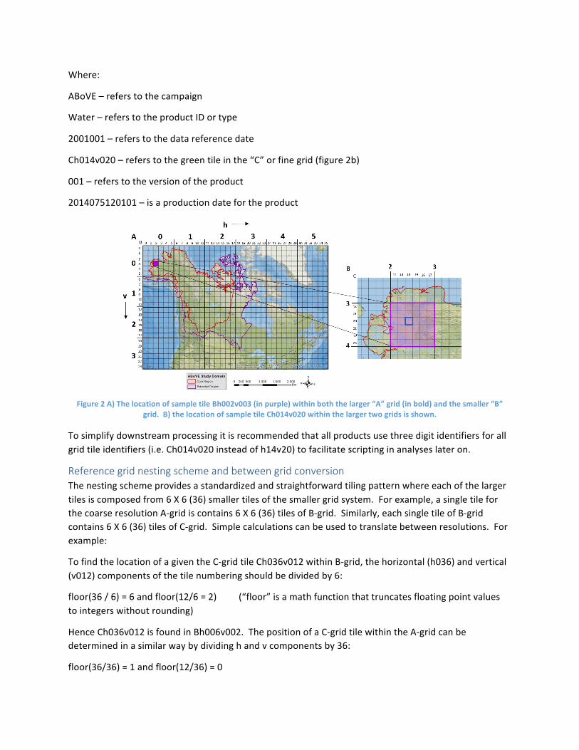
Where:
ABoVE–referstothecampaign
Water–referstotheproductIDortype
2001001–referstothedatareferencedate
Ah000v000–referstotheupperlefttileinthe“A”orlargergrid
001–referstotheversionoftheproduct
2014075120101–isaproductiondatefortheproduct
FortheB–grid:
ABoVE.water.2001001.Bh002v003.001.2014075120101.hdf
Where:
ABoVE–referstothecampaign
Water–referstotheproductIDortype
2001001–referstothedatareferencedate
Bh002v003–referstothepurpletileinthe“B”ormediumgrid(figure2a)
001–referstotheversionoftheproduct
2014075120101–isaproductiondatefortheproduct
FortheC–grid:
ABoVE.water.2001001.Ch014v020.001.2014075120101.hdf
Where:
ABoVE–referstothecampaign
Water–referstotheproductIDortype
2001001–referstothedatareferencedate
Ch014v020–referstothegreentileinthe“C”orfinegrid(figure2b)
001–referstotheversionoftheproduct
2014075120101–isaproductiondatefortheproduct
Figure2A)ThelocationofsampletileBh002v003(inpurple)withinboththelarger“A”grid(inbold)andthesmaller“B”grid.B)thelocationofsampletileCh014v020withinthelargertwogridsisshown.
Tosimplifydownstreamprocessingitisrecommendedthatallproductsusethreedigitidentifiersforallgridtileidentifiers(i.e.Ch014v020insteadofh14v20)tofacilitatescriptinginanalyseslateron.
Reference grid nesting scheme and between grid conversion Thenestingschemeprovidesastandardizedandstraightforwardtilingpatternwhereeachofthelargertilesiscomposedfrom6X6(36)smallertilesofthesmallergridsystem.Forexample,asingletileforthecoarseresolutionA-gridiscontains6X6(36)tilesofB-grid.Similarly,eachsingletileofB-gridcontains6X6(36)tilesofC-grid.Simplecalculationscanbeusedtotranslatebetweenresolutions.Forexample:
TofindthelocationofagiventheC-gridtileCh036v012withinB-grid,thehorizontal(h036)andvertical(v012)componentsofthetilenumberingshouldbedividedby6:
floor(36/6)=6andfloor(12/6=2) (“floor”isamathfunctionthattruncatesfloatingpointvaluestointegerswithoutrounding)
HenceCh036v012isfoundinBh006v002.ThepositionofaC-gridtilewithintheA-gridcanbedeterminedinasimilarwaybydividinghandvcomponentsby36:
floor(36/36)=1andfloor(12/36)=0

HenceCh036v012isinAh001v000.TranslatingfromtheB-gridtotheA-gridisthesameastranslatingfromC-gridtoB-grid,simplydividehandvby6.
GivenBh010v008:
floor(10/6)=1andfloor(8/6)=1
HenceBh010v008isinAh001v001.Thissimpletranslationmethodcanfacilitateanalysisthatrequiresusingmultipleproductsatvaryingspatialresolutions.AusercanalsosimplyquerytheassociatedshapefilesusingGISsoftwaretofindwhereafinerresolutiontilenestswithinthecoarserresolutiongrids.AshapefileforeachofthethreegridsisavailablefromtheOakRidgeNationalLaboratoryDAACorfromtheABoVEwebsite.Forfurtherinformationorquestionsregardingtheprojectionorgridpleasecontactsupport@cce.nasa.gov.