abstract volume 10 swiss geoscience...
TRANSCRIPT

Abstract Volume10th Swiss Geoscience MeetingBern, 16th – 17th November 2012
7. Stratigraphy in Switzerland - from field to application

162Sy
mp
osi
um
7:
Stra
tig
rap
hy
in S
wit
zerl
and
- f
rom
fie
ld t
o a
pp
lica
tio
n
Platform Geosciences, Swiss Academy of Science, SCNATSwiss Geoscience Meeting 2012
7. Stratigraphy in Switzerland - from field to application
Reto Burkhalter, Oliver Kempf, Karl Ramseyer, Ursula Menkveld-Gfeller, Christian Klug
swisstopo, Landesgeologie Schweizisches Komitee für Stratigraphie (SCNAT) Naturhistorisches Museum der Burgergemeinde Bern Schweizerische Paläontologische Gesellschaft
TALKS:
7.1 Bitterli-Dreher P.: Die Ifenthal-Formation im nördlichen Jura
7.2 Bonvallet L., Godet A., Spangenberg J.E., Arnaud A., Föllmi K.B.: The Urgonian Formation in the Helvetic Alps (late Barremian to early Aptian): a multidisciplinary approach for the correlation of a transect through the Säntis realm
7.3 Graf H.R., Burkhalter R.: Die Ablagerungen des Eiszeitalters: stratigrafisches Konzept und Nomenklatur am Beispiel der Nordschweiz
7.4 Hochuli P.A., Rebetez D., Schneebeli-Hermann E., Ramseyer K.: Middle Triassic of the Weiach borehole – results from palynology and isotope chemostratigraphy
7.5 Hostettler B.: New lithostratigraphic units for the Callovian stage in the central NW Swiss Jura Mountains
7.6 Jordan P., Arbeitsgruppe Jura-Ost SKS: Neugliederung der Trias in der Nordschweiz – ein Diskussionsvorschlag
7.7 Jost J., Kempf O., Kälin D.: Stratigraphy of the Upper Marine Molasse in central Switzerland
7.8 Morard A., Burkhalter R., Möri A., Strasky S.: Lithostratigraphy of Switzerland – options and challenges for a harmonisation
7.9 Reisdorf A.G., Wetzel A., Schlatter R., Jordan P.: A new stratigraphic scheme for the Early Jurassic of northern Switzerland: the Staffelegg Formation
7.10 Strasser A., Charollais J., Conrad M., Clavel B.: Facies heterogeneity versus lithostratigraphic nomenclature – examples from shallow-water limestones in the Swiss Jura

163
Sym
po
siu
m 7
: St
rati
gra
ph
y in
Sw
itze
rlan
d -
fro
m f
ield
to
ap
pli
cati
on
Platform Geosciences, Swiss Academy of Science, SCNATSwiss Geoscience Meeting 2012
POSTERS:
P 7.1 Derakhshan E., Khaksar K., KebriaeiZadeh M.R.: Lower Carboniferous corals from Gerd-kuh section, Eastern Alborz, North Iran
P 7.2 Gouffon Y., Sartori M., Marthaler M.: Lithostratigraphy of Penninic nappes in Valais: legend harmonisation of the Geological Atlas of Switzerland
P 7.3 Khaksar K., Yazdizadeh H., KebriaeiZadeh M.R.: Frasnian reef biostromes of the Hojedk section, North Kerman, Central Iran
P 7.4 Khaksar K., Nazif L., KebriaeiZadeh M.R.: Lower Carboniferous corals from the Namake section in the North Damghan, East Alborz, Iran
P 7.5 Meier I., Bernasconi S.M., Ramseyer K., Brack P., Bläsi H.-R., Wohlwend S., Hochuli P.A.: Sulfur isotope stratigraphy of Middle to Upper Triassic marine evaporites in the Jura Mountains, Northern Switzerland
P 7.6 Ragusa J., Ospina-Ostios L.-M., Kindler P.: Using Dickinson›s method for a better understanding of the origin of the Voirons Flysch (Gurnigel nappe, Haute-Savoie, France)
P 7.7 Reber R., Akçar N., Ivy-Ochs S., Tikhomirov D., Burkhalter R., Zahno C., Lüthold A., Kubik P.W., Vockenhuber C., Schlüchter C.: The last deglaciation of the northern Alpine Foreland: evidence from the Reuss Glacier
P 7.8 Rebetez D., Ramseyer K.: The Middle Triassic (Anisian) marine transgression in the Tödi area, Central Switzerland
P 7.9 Wohlwend S., Weissert H.: From “black shales” to red beds in the northern Helvetic Seewen Formation (Cenomanian–Turonian)

164Sy
mp
osi
um
7:
Stra
tig
rap
hy
in S
wit
zerl
and
- f
rom
fie
ld t
o a
pp
lica
tio
n
Platform Geosciences, Swiss Academy of Science, SCNATSwiss Geoscience Meeting 2012
7.1
Die Ifenthal-Formation im nördlichen Jura
Bitterli-Dreher Peter
Wolfgalgen 4, CH-5304 Endingen ([email protected])
Die Schichten des „oberen Doggers“ (später Mitteljura) im Gebiet des Schweizer Juras bilden zwei regressive Schelfzyklen (Shallowing-Upward-Zyklen). Sie bestehen aus Gesteinsabfolgen mit zunehmender Korngrösse im Verlauf eines Zyklus. Tonige oder mergelige Gesteine an der Basis der Zyklen gehen in Mergel mit Knauerlagen und schliesslich in schräg ge-schichtete Kalkarenite über. Im Dach der Kalkarenite sind regionale Hartgründe ausgebildet, auf denen geringmächtige Eisenoolithe lagern.
Der zyklische Charakter der Ablagerungen eignet sich zur lithostratigraphischen Unterteilung der Abfolge. Die harten Kalkarenite prägen sich im Gelände als Felsrippen aus, die weicheren Mergel bilden ausgeprägte Senken (Comben). Typische Lithologien geringmächtiger Gesteinsbänke können auch in Lesesteinen erkannt werden. Die Mächtigkeit des Schichtstosses erreicht im Gebiet Hauenstein, Allerheiligenberg rund 45 m und nimmt gegen Nordosten auf wenige Dezimeter ab (z.B. Auenstein, AG).
Auf den Karten des Geologischen Atlas der Schweiz 1:25'000 wird die gesamte Abfolge mit einer Formation dargestellt: Die Ifenthal-Formation umfasst den Schichtstoss zwischen dem Hartgrund im Dach der Hauptrogenstein-Formation und dem Birmenstorf-Member an der Basis der Wildegg-Formation, welches sich lithologisch und farblich vom Herznach-Member der Ifenthal-Formation unterscheidet.
Das Typusgebiet liegt in der Hauenstein-Synklinale S Ifenthal. Die starken lithologischen Kontraste erlauben eine Unterteilung der Formation in mehrere Member. Chronostratigraphisch umfasst die Ifenthal-Formation ein Intervall vom frühen Bathonien (Progracilis-Zone?) bis ins frühe Oxfordien (Cordatus-Zone).
Das Schweizerische Stratigraphische Komitee hat die Ifenthal-Formation und ihre Member anlässlich der Sitzung vom 12. Januar 2012 akzeptiert.
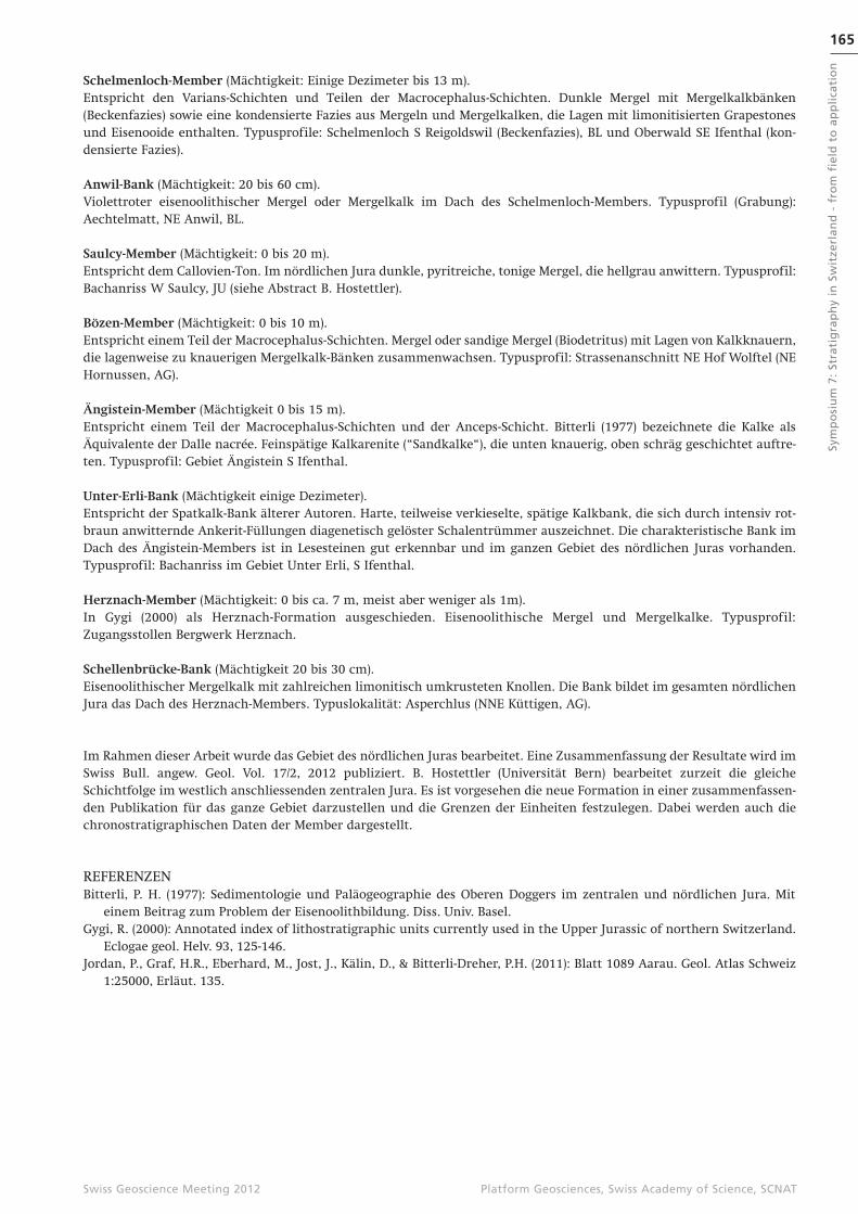
Figur 1: Vergleich der Ifenthal-Formation mit älteren Einheiten.
165
Sym
po
siu
m 7
: St
rati
gra
ph
y in
Sw
itze
rlan
d -
fro
m f
ield
to
ap
pli
cati
on
Platform Geosciences, Swiss Academy of Science, SCNATSwiss Geoscience Meeting 2012
Schelmenloch-Member (Mächtigkeit: Einige Dezimeter bis 13 m).Entspricht den Varians-Schichten und Teilen der Macrocephalus-Schichten. Dunkle Mergel mit Mergelkalkbänken (Beckenfazies) sowie eine kondensierte Fazies aus Mergeln und Mergelkalken, die Lagen mit limonitisierten Grapestones und Eisenooide enthalten. Typusprofile: Schelmenloch S Reigoldswil (Beckenfazies), BL und Oberwald SE Ifenthal (kon-densierte Fazies).
Anwil-Bank (Mächtigkeit: 20 bis 60 cm).Violettroter eisenoolithischer Mergel oder Mergelkalk im Dach des Schelmenloch-Members. Typusprofil (Grabung): Aechtelmatt, NE Anwil, BL.
Saulcy-Member (Mächtigkeit: 0 bis 20 m).Entspricht dem Callovien-Ton. Im nördlichen Jura dunkle, pyritreiche, tonige Mergel, die hellgrau anwittern. Typusprofil: Bachanriss W Saulcy, JU (siehe Abstract B. Hostettler).
Bözen-Member (Mächtigkeit: 0 bis 10 m).Entspricht einem Teil der Macrocephalus-Schichten. Mergel oder sandige Mergel (Biodetritus) mit Lagen von Kalkknauern, die lagenweise zu knauerigen Mergelkalk-Bänken zusammenwachsen. Typusprofil: Strassenanschnitt NE Hof Wolftel (NE Hornussen, AG).
Ängistein-Member (Mächtigkeit 0 bis 15 m).Entspricht einem Teil der Macrocephalus-Schichten und der Anceps-Schicht. Bitterli (1977) bezeichnete die Kalke als Äquivalente der Dalle nacrée. Feinspätige Kalkarenite (“Sandkalke“), die unten knauerig, oben schräg geschichtet auftre-ten. Typusprofil: Gebiet Ängistein S Ifenthal.
Unter-Erli-Bank (Mächtigkeit einige Dezimeter).Entspricht der Spatkalk-Bank älterer Autoren. Harte, teilweise verkieselte, spätige Kalkbank, die sich durch intensiv rot-braun anwitternde Ankerit-Füllungen diagenetisch gelöster Schalentrümmer auszeichnet. Die charakteristische Bank im Dach des Ängistein-Members ist in Lesesteinen gut erkennbar und im ganzen Gebiet des nördlichen Juras vorhanden. Typusprofil: Bachanriss im Gebiet Unter Erli, S Ifenthal.
Herznach-Member (Mächtigkeit: 0 bis ca. 7 m, meist aber weniger als 1m).In Gygi (2000) als Herznach-Formation ausgeschieden. Eisenoolithische Mergel und Mergelkalke. Typusprofil: Zugangsstollen Bergwerk Herznach.
Schellenbrücke-Bank (Mächtigkeit 20 bis 30 cm).Eisenoolithischer Mergelkalk mit zahlreichen limonitisch umkrusteten Knollen. Die Bank bildet im gesamten nördlichen Jura das Dach des Herznach-Members. Typuslokalität: Asperchlus (NNE Küttigen, AG).
Im Rahmen dieser Arbeit wurde das Gebiet des nördlichen Juras bearbeitet. Eine Zusammenfassung der Resultate wird im Swiss Bull. angew. Geol. Vol. 17/2, 2012 publiziert. B. Hostettler (Universität Bern) bearbeitet zurzeit die gleiche Schichtfolge im westlich anschliessenden zentralen Jura. Es ist vorgesehen die neue Formation in einer zusammenfassen-den Publikation für das ganze Gebiet darzustellen und die Grenzen der Einheiten festzulegen. Dabei werden auch die chronostratigraphischen Daten der Member dargestellt.
REFERENZENBitterli, P. H. (1977): Sedimentologie und Paläogeographie des Oberen Doggers im zentralen und nördlichen Jura. Mit
einem Beitrag zum Problem der Eisenoolithbildung. Diss. Univ. Basel.Gygi, R. (2000): Annotated index of lithostratigraphic units currently used in the Upper Jurassic of northern Switzerland.
Eclogae geol. Helv. 93, 125-146.Jordan, P., Graf, H.R., Eberhard, M., Jost, J., Kälin, D., & Bitterli-Dreher, P.H. (2011): Blatt 1089 Aarau. Geol. Atlas Schweiz
1:25000, Erläut. 135.
166Sy
mp
osi
um
7:
Stra
tig
rap
hy
in S
wit
zerl
and
- f
rom
fie
ld t
o a
pp
lica
tio
n
Platform Geosciences, Swiss Academy of Science, SCNATSwiss Geoscience Meeting 2012
7.2
The Urgonian Formation in the Helvetic Alps (late Barremian to early Aptian): a multidisciplinary approach for the correlation of a transect through the Säntis realm.
Bonvallet Lucie1, Godet Alexis1, Spangenberg Jorge E. 2, Arnaud Annie 3 & Föllmi Karl B. 1
1 Institute of Geology and Paleontology, University of Lausanne, Anthropole, CH-1015 Lausanne ([email protected])2 Institute of Mineralogy and Geochemistry, University of Lausanne, Anthropole, CH-1015 Lausanne Switzerland3Association Dolomieu, 6 chemin des Grenouilles, 38700 France
Urgonian platform carbonates are a common feature of subtropical and tropical shallow-water environments of late Early Cretaceous age. They include the remains of rudists, corals, chaetetids and stromatoporoids, which are interpreted as in-dicators of a predominantly photozoan, oligotrophic carbonate-producing ecosystem. The late Early Cretaceous is also marked by the occurrence of several oceanic anoxic episodes, such as the latest Hauterivian Faraoni and the early Aptian Selli Events, which are both interpreted as the consequence of generalized eutrophic conditions. These observations imply that the late Early Cretaceous underwent larger f luctuations in nutrient supply, which may have interfered with the evo-lution of the widespread Urgonian platforms.
Our goal is to study the interactions between paleoceanographic and paleoclimatic change, and Urgonian carbonate buil-dup in the northern, Helvetic Alps. This unit remains understudied relative to its counterparts in eastern and central France. We specifically intend to compare the Urgonian units of late Barremian age and early Aptian age, which are sepa-rated by the so-called “Lower Orbitolina Beds”. The late Barremian was less affected by anoxia, whereas the early Aptian witnessed progressive change in paleoceanographic conditions, which led up to the Selli Event.
The preliminary results of a proximal-distal transect is presented; it consists of three sections, on which an analysis of geochemical proxies, such as phosphorus and stable-isotope (C, O) contents, have been performed. Two sections (Tierwis, Valsloch) belong to the Säntis nappe whereas the most proximal section (Kistenpass) has been prospected in the Infrahelvetic area. Based on sedimentological and geochemical data, a correlation with the Alvier section (after Briegel, 1972, and Wissler et al., 2003), which corresponds to the distalmost part of the platform, aims to pinpoint depositional geometries, which are necessary to develop a sequence-stratigraphic model.
7.3
Die Ablagerungen des Eiszeitalters: stratigrafisches Konzept und Nomenklatur am Beispiel der Nordschweiz
Graf, Hans Rudolf1, Burkhalter, Reto2
1Dr. von Moos AG, Mäderstrasse 8, 5400 Baden ([email protected])2Bundesamt für Landestopografie, Geologische Landesaufnahme, Seftigenstrasse 264, 3084 Wabern ([email protected])
Im Auftrag der Schweizerische Geologische Landesaufnahme wurde ein strati-grafisches Konzept für Gliederung und Nomenklatur der Ablagerungen des Eis-zeitalters für den Geologischen Atlas der Schweiz 1:25›000 erarbeitet, welches den gültigen „Richtlinien zur stratigraphischen Nomenklatur“ (Remane et al. 2005) genügt.
Zuerst wurde untersucht, ob die bisher als Basis für Gliederung und Darstellung der eiszeitlichen Ablagerungen auf den Blättern des Geologischen Atlas der Schweiz 1:25›000 verwendete so genannte „klassische“ Gliederung, welche im süd-deutschen Alpenvorland erarbeitet wurde (Penck & Brückner 1901-09), weiterhin verwendet werden kann. Anhand eines Überblicks über den aktuellen Kenntnisstand der Quartärgliederung in diesem Gebiet sowie der Nordschweiz wird aufge-zeigt, dass (insbesondere im Rheingletschergebiet) für Mittel- und Spätpleistozän durchaus vergleichbare, für das Frühpleistozän aber stark diver-gierende Befunde vorliegen. Dass dies nicht ein Frage des Kenntnisstandes, sondern mit grundsätzlichen Unterschieden der beiden Gebiete zu begründen ist, wird anhand einer Betrachtung über die jeweiligen Steuerungsmechanismen der regionalen Morphogenese aufgezeigt. Ein wesentliches Element bei der Entwicklung des

167
Sym
po
siu
m 7
: St
rati
gra
ph
y in
Sw
itze
rlan
d -
fro
m f
ield
to
ap
pli
cati
on
Platform Geosciences, Swiss Academy of Science, SCNATSwiss Geoscience Meeting 2012
Gewässernetzes ist die Hebung der Alpen, welche für beide Gebiete als vergleichbar angenommen werden kann. Für die zum Rheinsystem entwässernde Nordschweiz spielt aber das seit dem Eozän aktive Senkungsge-biet des Oberrheingrabens eine mindestens ebenso grosse Rolle. Im zur Donau entwässernden Deutschen Alpenvorland fehlt ein entsprechendes Senkungsge-biet. Somit ist von einer grundsätzlich unterschiedlichen tektonisch-geomorpho-logischen Entwicklung der beiden Regionen auszugehen, die eine Korrelierung anhand von geomorpholgischen Kriterien grundsätzlich in Frage stellt.
Vor diesem Hintergrund wurde ein Gliederungs- und Nomenklaturkonzept ausgearbeitet, welches neu für den Geologischen Atlas der Schweiz 1:25‘000 zur Anwendung kommt. Es baut auf den allgemein gültigen Richtlinien für die Ausscheidung und Nomenklatur von lithostratigrafischen Einheiten auf, die vom Schweizerischen Komitee für Stratigrafie erarbeitet wurden. Es wird gezeigt, wie die spezifischen Eigenschaften der Ablagerungen des Eiszeitalters im Rahmen dieser Vorgaben berücksichtigt werden können. Schliesslich wird ein Vorschlag für ein entsprechendes Legenden- und Kürzelsystem für geologische Kartenblätter vorgestellt (Fig. 1).
LITERATURPenck, A. & Brückner, E. 1901–1909: Die Alpen im Eiszeitalter, 3 Bde., Tauchnitz, Leipzig.Remane, J., Adatte, T., Berger, J.-P., Burkhalter, R., Dall’Agnolo, S., Decrouez, D., Fischer, H., Funk, H., Furrer, H., Graf, H.R.
Gouffon, Y., Heckendorn, W. & Winkler, W. 2005: Richtlinien zur Stratigraphischen Nomenklatur, Eclogae. geol. Helv. 98, 385-405.
Figur 1. Legendenaufbau für die Ablagerungen des Eiszeitalters
im Geologi-schen Atlas der Schweiz 1:25‘000 (Beispiel aus der
Nordschweiz, z.T. hypothetisch).
168Sy
mp
osi
um
7:
Stra
tig
rap
hy
in S
wit
zerl
and
- f
rom
fie
ld t
o a
pp
lica
tio
n
Platform Geosciences, Swiss Academy of Science, SCNATSwiss Geoscience Meeting 2012
7.4
Middle Triassic of the Weiach borehole – results from palynology and iso-tope chemostratigraphy
Hochuli Peter A.1, Rebetez Daniel2, Schneebeli-Hermann Elke1 & Ramseyer Karl2
1Palaeontological Institute and Museum, University Zürich, Karl Schmid-Strasse 4, CH-8006 Zürich, Switzerland ([email protected])2Institute of Geological Sciences, University of Bern, Baltzerstrasse 1+3, CH-3012 Bern, Switzerland
The Middle Triassic (Anisian) of the Weiach borehole comprising the Plattensandstein, Wellendolomit, Wellenmergel, Orbicularis-Mergel and the Sulfatschichten has been studied for palynology, palynofacies and C isotope chemostratigraphy.
The detailed study of well-preserved sporomorphs allowed the discrimination of four distinct spore-pollen assemblages (A-D). The presence of acritarchs and foraminiferal linings in the interval from the Plattensandstein to the top of the Orbicularis Mergel documents marine depositional environments; above there is no indication of a marine influence.
The lowest assemblage A, observed in the Plattensandstein, Wellendolomit and the Wellenmergel, is dominated by a high-ly diverse pollen assemblage associated with a number of spores (e.g., Densoisporites nejburgii), which are typical for Early Triassic, but are known to range up into the basal part of the Middle Triassic. This assemblage is closely comparable with spore-pollen associations of the upper Röt Fm. (topmost Buntsandstein) from the central part of the Germanic Basin (e.g., Germany, Poland and Netherlands; for references see compilation of Kürschner & Herngreen, 2010). Similar assemblages are also known from the lower part of the Grès à Voltzia of eastern France (Adloff & Doubinger, 1969). The above menti-oned assemblages, including assemblage A, are interpreted to correspond to an early Anisian (Aegean) age (Kürschner & Herngreen, 2010).
A different type of assemblage (Assemblage B) has been recovered from the Orbicularis Mergel. It is characterised by the dominance of the xerophytic conifer group Triadispora, whereas the abundance and diversity of spores are reduced. This assemblage compares well with those ranging from the uppermost Röt Fm. to the lowermost Middle Muschelkalk (Jena Fm.) of the central part of the Germanic Basin. A latest Aegean to Illyrian age is suggested for this interval (Heunisch, 1999; Kürschner & Herngreen, 2010).
The quantitative composition of the following Assemblage C is similar to assemblage B, but contains a few specific marker species (e.g., Dyupetalum vicentinensis). Spores occur only sporadically. In the Weiach borehole assemblage C has been obser-ved in the lower part of the Sulfatschichten. In the central Germanic Basin comparable spore-pollen associations have been reported from the Jena Fm. and the lower part of the Heilbronn Fm. Based on the appearance of the marker species a Pelsonian age has been suggested (for reference see Kürschner & Herngreen, 2010).
Assemblage D is defined by the appearance of a few marker species (e.g., Podosporites amicus). In comparison to assemblage C there are only slight differences in the quantitative composition of the pollen assemblage. Assemblage D covers the upper part of the Sulfatschichten. Comparable assemblages have been published from the Heilbronn Fm., the Trochitenkalk Fm. and the Meissner Fm. They are interpreted to correspond to the Illyrian (Heunisch, 1999; Kürschner & Herngreen, 2010).
The main turnover in the sporomorph association – between Assemblage A and B - is interpreted to reflect a distinct inc-rease in aridity. This change coincides with a marked negative shift in the d13C isotope values. This negative shift confirms the environmental turnover suggested by the spore-pollen assemblage. Negative shifts are usually related to volcanic ac-tivity ejecting CO2. Increased CO2 affects the global carbon cycle and hence the climate.
The present age interpretation of palynological results contradicts the generally accepted correlations based on lithologic similarities. The new age model implies a pronounced heterochronity of Middle Triassic lithofacies and has important consequences for the palaeogeography of the epicontinental Germanic Basin.
REFERENCESAdloff, M-C. & Doubinger, J. 1969: Etude palynologique dans le Grès à Voltzia (Trias inférieur), Bull. Serv. Carte géol.
Alsace Lorraine, 22/2, 131-148.Heunisch, C. 1999: Die Bedeutung der Palynologie für Biostratigraphie und Fazies in der Germanischen Trias. In:
Hauschke, N. & Wilde, V. (Eds.) Trias, eine ganz andere Welt, Mitteleuropa im frühen Erdmittelalter. München, Pfeil Verlag, 207–220.
Kürschner, W.M. & Herngreen, W. 2010: Triassic palynology of central and northwestern Europe: a review of palynofloral diversity patterns and biostratigraphic subdivisions In: Lucas, S.G. (Ed.) The Triassic Timescale. Geological Society, London, Special Publications, 334, 263–283.
169
Sym
po
siu
m 7
: St
rati
gra
ph
y in
Sw
itze
rlan
d -
fro
m f
ield
to
ap
pli
cati
on
Platform Geosciences, Swiss Academy of Science, SCNATSwiss Geoscience Meeting 2012
7.5
New lithostratigraphic units for the Callovian stage in the central NW Swiss Jura Mountain
Hostettler Bernhard
Naturhistorisches Museum der Burgergemeinde Bern, Bernastrasse 15, CH-3005 Bern Institut für Geologie, Universität Bern, Baltzerstrasse 1+3, CH-3012 Bern ([email protected])
Numerous lithostratigraphic units, e.g., Dalle nacrée, Lumachellenbank or Callovien Ton, are in use in the Callovian stage of the central NW part of the Swiss Jura Mountains which are mainly based on biostratigrapy. Here we present a new li-thostratigraphy in accordance with the rules of the international stratigraphical comission. The proposed members are part of the Ifental Fm. (Bitterli-Dreher, 2012) and an additional formation (e.g., Bollement Mb.) to be defined in the future.
Châtillon Member (previously Macrocephalen-Kalke). The typlocality is at Sur le Mont, SW Châtillon JU (591 650/239 800). Lithologically, it is a grey, biomicritic marl at the base and a very fossiliferous (bivalves, ammonites) limestone which contains sometimes iron-ooids. The limestone bed is normally condensed. In the region of Liesberg the limestone is split into several beds interlayered with marls. The thickness varies between 30cm (typlocality) and 2.8m (Liesberg) (Dietl and Gygi, 1998).
Saulcy Member (previously Callovien Ton). The typlocality is in the riverbed 250m west of STEP (station d’épuration), Saulcy JU (577 650/238 800).Lithologically, it is a grey marl to marly clay with a poor macrofauna (e.g., Bositra buchi) but locally a rich microfauna (e.g., echinoderm ossicles, foraminifera). The thickness varies between 1.2m (Col de la Croix, JU) and 16m.
Les Fuchies Member (previously Dalle nacrée Äquivalent). The typlocality isat the roadcut E les Fouchies, S Courtételle, JU (591 275/240 200).Lithologically, it is a fine-grained light grey to beige biomicritic marly limestone to limestone. In the lower part marly intercalations and in the upper part with a tendence to cross-bedding. Thickness: 2 m (Saulcy) to 15 m (S. of Soulce JU)
Bollement Member (previously Dalle nacrée). The typlocality is at the roadcut E. railway station Bollement JU (576 300/238 600). This unit is ca. 20 m, thin-bedded, middle to coarse grained and mostly cross-bedded biosparitic grey to brown lime-stone with some oolites. The fossil content consists of echinoderm ossicles, bryozoan branches, bivalve- and brachiopod shells. The unit contains often chert nodules or layers.
Unter Erli-Bank (part of the Herznach Member) (previously Lumachellenbank.Lithologically it is a beige to dark grey hard biomicrite with abundant bivalves, ammonites and shell fragments. The thickness in the study area is 30 cm.
Herznach Member (previously Herznach Formation, Anceps-Athleta beds, fer sous oxfordien or eisenoolithische Lumachellenbank). The typlocality is at the Bergwerk Herznach. Lithologically it is a grey, red (weathered yellow to beige) iron-oolithic marl to marly limestone often with a rich fauna (e.g., ammonites, bivalves, gastropods, echinids.)
Graitery Member (previously Kellaway, Renggeri Tone). The typlocality is nearCombe d`Eschert, BE (597 250/233 650). Lithologically it is a gray marl with some marly limestone beds. Except of the middle part this member is very fossiliferous (e.g., ammonites, echinids, sponges, brachiopods). In the upper part glauco-nite and phosphatized ammonites. The thickness at the typlocality is 9-12m
REFERENCESBitterli-Dreher, P.H. 2012: Zur Geologie der Ifental-Formation. Swiss Bull. angew. Geol. 17/2.Dietl & Gygi, R. 1998: Die Basis des Callovian (Mittlerer Jura) bei Liesberg, Eclogae geol. Helv. 91 247-260

170Sy
mp
osi
um
7:
Stra
tig
rap
hy
in S
wit
zerl
and
- f
rom
fie
ld t
o a
pp
lica
tio
n
Platform Geosciences, Swiss Academy of Science, SCNATSwiss Geoscience Meeting 2012
7.6
Neugliederung der Trias in der Nordschweiz – ein Diskussionsvorschlag
Peter Jordan1 & Arbeitsgruppe Jura-Ost des Schweizerischen Komitees für Stratigraphie SKS2
1Geologisch-Paläontologisches Institut, Universität Basel, Bernoullistrasse 32, CH-4056 Basel ([email protected]; [email protected])2c/o Werner Heckendorn, Leiter SKS Jura-Ost, Mühlerain 25,5200 Brugg ([email protected])
Zur Zeit der Trias war die Nordschweiz ein Randbereich des Germanischen Faziesraums. Entsprechend einfach konnten die Definitionen des Buntsandsteins (A. G. Werner ca. 1780), Muschelkalks (G.C. Füchsel 1761) und Keupers (L. von Buch, ca. 1820) auf die hiesigen Verhältnisse übertragen werden, und fanden bald, wie auch der 1834 von F.A. von Alberti ge-schaffene Sammelbegriff «Trias», Eingang in die lokale Fachliteratur (z.B. Gressly in Desor 1856, Heer 1865).
Später wurden in der Schweiz zur weiteren Unterteilung sukzessive Formationsnamen und -definitionen aus näheren und ferneren Regionen mehr oder weniger glücklich übernommen oder neu kreiert. Dabei gelang es nicht, zu vermeiden, dass vorhandene lithostratigraphische Definitionen frei interpretiert, bestimmte Abfolgen mehrfach, aber unterschiedlich benannt und ähnliche Namen für unterschiedliche Formationen verwendet wurden.

171
Sym
po
siu
m 7
: St
rati
gra
ph
y in
Sw
itze
rlan
d -
fro
m f
ield
to
ap
pli
cati
on
Platform Geosciences, Swiss Academy of Science, SCNATSwiss Geoscience Meeting 2012
Monographien zur gesamten Trias der Nordschweiz oder zu den heute als Gruppen verstandenen Teilgliedern Buntsandstein, Muschelkalk und Keuper gibt es bislang nicht und zu deren Formationen und Member nur wenige: So nimmt sich Merki (1961) dem Oberen Muschelkalk und Erni (1926) dem Rhät der Nordschweiz an. Dronkert et al. (1990) und Widmer (1991) beschreiben die Evaporit-Abfolgen des Keupers und Muschelkalks. Weitere Arbeiten untersuchen vor allem die Verhältnisse im angrenzenden Baden-Württemberg: Etwa Ortlam 1974 den Buntsandstein, Frank 1929 und Becker et al. 1997 das Wellengebirge, Wurster 1968 den Lettenkeuper und Wurster 1964 den Schilfsandstein und die Bunte Mergel.
Die Arbeitsgruppe Jura-Ost des Schweizerischen Komitees für Stratigraphie SKS (Burkhalter & Heckendorn 2009) hat die Überarbeitung der jurazeitlichen Formationen abgeschlossen und wird sich nun denen der Trias widmen. Zu diesem Zweck wurde eine Gesamtschau der vorhandenen Informationen durchgeführt und darauf basierend ein Diskussionsvorschlag zur Neugliederung der Trias in der Nordschweiz ausgearbeitet. Mit dieser integralen Betrachtungsweise soll schon zu Beginn eine generelle Gliederung geschaffen werden, welche sich streng an die Vorgaben der SKS (Remane et al. 2005) hält: Im Vordergrund steht die Kartierbarkeit und Darstellbarkeit auf Karten 1:25'000, das einfache Erkennen und Abgrenzen der Formationen nicht nur in Bohrungen und Aufschlüssen, sondern auch im aufschlussarmen Gelände. Daher wird wahrscheinlich mit verschiedenen etablierten, teilweise willkürlich, teilweise aufgrund von chrono-, bio- oder allostrati-graphischen Überlegungen eingeführten Unterteilungen gebrochen werden müssen. Der Vorschlag einer neuen generel-len Gliederung soll daher bereits früh dem interessierten Publikum zur Diskussion unterbreitet werden.
Innerhalb dieser generellen Gliederung sollen anschliessend die Formationen und Schichtglieder genau oder, wenn nötig, neu definiert werden. Dabei stellt sich die Frage, in wie weit man sich der kürzlich in Deutschland neu etablierten Trias-Stratigraphie anschliessen will (vgl. Geyer & Gwinner 2011 für eine Zusammenstellung der Verhältnisse im angrenzenden Baden-Württemberg). Dies wäre sicher eine noch zu diskutierende Novität, die sich aber durch die paläogeographische Rand-Situation des betrachten Gebietes wie auch aus aktueller geologischer Sicht rechtfertigen liesse.
REFERENZENBecker, F., Lutz, M., Hoppe, A. & Etzold, A. 1997: Der Untere Muschelkalk am Südostrand des Schwarzwaldes –
Lithostratigraphie und Gammastrahl-Log-Korrelation. Jb. Mitt. Oberrhein. geol. Ver.,, N.F., 79, 91-109.Burkhalter, R. & Heckendorn, W. 2009: Das Stratigraphische Komitee der Schweiz (SKS). Swiss Bull. angew. Geol., 14,
159-162.Desor, E. 1856: Les Tunnels du Jura. Revue Suisse du 15 Novembre 1856Dronkert, H., Bläsi, H.-R. & Matter, A. 1990: Facies and origin of Triassic evaporites from the Nagra boreholes, northern
Switzerland. Geol Ber Landeshydrol . u -geol Vol 12, 120 p.Erni, A. 1926: Zur Rhätfrage im Schweizer Juragebirge. Centralblatt für Mineralogie, Geologie und Paläontologie,
Abteilung B, 7, 241–253.Frank, M. 1929: Zur Stratigraphie und Paläogeographie des Wellengebirges im südlichen Schwarzwald. Mitt. Min.-Geol.
Inst. T.H. Stuttgart, 6, 38 p.Geyer, O.F. & Gwinner, M.P. 2011: Geologie von Baden Württemberg [M. Geyer, E. Nitsch, T. Simon, eds.]. Stuttgart
(Schweizerbart), 627 p.Heer, 0. 1865: Die Urwelt der Schweiz, Zürich (Schulthess), 622 p.Merki, P. 1961: Der Obere Muschelkalk im östlichen Schweizer Jura. Eclogae geol. Helv. 54, 137-219 Ortlam, D. 1974: Inhalt und Bedeutung fossiler Bodenkomplexe in Perm und Trias von Mitteleuropa. Geol. Rdschau, 63,
850-884 Remane, J., Adatte, T., Berger, J.-P., Burkhalter, R., Dall’Agnolo, S., Decrouez, D., Fischer, H., Funk, H., Furrer, H., Graf,
H.-R., Gouffon, Y., Heckendorn, W., & Winkler, W. 2005: Richtlinien zur stratigraphischen Nomenklatur. Eclogae geol. Helv. 98, 385-405.
Widmer, Th. 1991: Stratigraphie und Sedimentologie der Evaporite des Muschel kalks im Basler Tafeljura. Beitr. Geol. Schweiz, Geotech. Serie, Band 79, 107 p.
Wurster,P. 1964: Geologie des Schilfsandsteins.- Mitt. geol. Staatsinst. Hamburg, 33, 1-140. Wurster,P. 1968: Paläogeographie der deutschen Trias und die paläogeo-graphische Orientierung der Lettenkohle in
Südwestdeutschland.- Eclogae geol. Helv., 61, 157-166.

172Sy
mp
osi
um
7:
Stra
tig
rap
hy
in S
wit
zerl
and
- f
rom
fie
ld t
o a
pp
lica
tio
n
Platform Geosciences, Swiss Academy of Science, SCNATSwiss Geoscience Meeting 2012
7.7
Stratigraphy of the Upper Marine Molasse in central Switzerland
Jost Jürg1, Kempf Oliver2, Kälin Daniel3
1Bärenhubelstrasse 10, CH-4800 Zofingen ([email protected])2swisstopo, Landesgeologie (Swiss Geological Survey), Seftigenstrasse 264, CH-3084 Wabern ([email protected])3swisstopo, Landesgeologie (Swiss Geological Survey), Seftigenstrasse 264, CH-3084 Wabern (daniel.kä[email protected])
This presentation aims at a new classification of Upper Marine Molasse (OMM) sediments of the central Swiss Molasse Basin (Zofingen region).
In Switzerland OMM-sediments (Burdigalian, early-middle Miocene) are classically subdivided into the Lucerne and St Gallen formations based on detailed field studies of the last decades. This subdivison can so far best be applied in beauti-fully exposed OMM-sediments along the southern basin margin (Keller 1989), where several hundred meter thick succes-sions are available. In that region, the base of the St Gallen formation is defined by a transgressive surface that developed on top of partly terrestrial sediments of the Lucerne formation underneath. There, small mammal teeth allow a correlati-on of both formations to the Neogene mammal stratigraphy: faunas of the Lucerne formation revealed MN3a and MN3b ages, while the St Gallen formation is of MN4 (probably MN4b; Keller 1989) age.
Classification of OMM-sediments in central parts of the Molasse Basin has been carried out by Büchi (1957, 1958) based purely on lithostratigraphy. He used well-recognizable beds of frequent occurrence and established a system of sandstone „zones“ separated by these marker beds. For instance, the separation of the Lucerne and St. Gallen formation („Burdigalien“ and „Helvétien“, respectively) was tentatively drawn at the base of the well-visible and widespread „basal conglomerate“. However, while studying the fossil teeth of OMM-faunas (particularly sharks and rays) it became obvious that these beds were not at all good biostratigraphic markers (a fact Büchi already assumed).
At the southern basin margin, a transgressive surface at the base of the St Gallen formation indicates a basin-wide trans-gression and thus an overall increase in water depth with the onset of the formation. Based on this premise, we investiga-ted the faunal evolution through time in detail. It turned out that based on the composition of shark and ray teeth open marine conditions of greatest diversity and deepest water occurred long before the occurrence of the first conglomerate beds. Moreover, the faunal compositions indicate rather unstable marine conditions above those conglomerates. We found these highly diverse open marine faunas in particularly coarse-grained, pebbly sandstones that are abundantly distributed across the investigated region. This bed, the „Staffelbach-Grobsandstein“, is located above the „Muschelsandstein“. Therefore, the onset of the St Gallen formation in the investigated area occurred earlier in the succession than assumed. Ages based on mammal teeth, which show a wide range of MN3b-MN4, are somewhat irritating but can be explained by intense reworking in this particular sandstone. We therefore propose that the „Staffelbach-Grobsandstein“ represents the base of the St Gallen formation. Onset and termination of marine conditions most probably established gradually, a clear, sharp marine/terrestrial facies change can nowhere be observed.
• Age of the terminal Lower Freshwater Molasse (USM): younger MN2a to early MN2b • Age of the Lucerne formation (Upper Marine Molasse, OMM-I): younger MN3a; younger deposits of
the formation especially the „Muschelsandstein“ revealed until now no biostratigraphic data • Age of the St Gallen formation (Upper Marine Molasse, OMM-II): younger MN3b/older MN4 within
the „Staffelbach-Grobsandstein“, and MN4b from ca. 20 m above it until the top• Age of the earliest Upper Freshwater Molasse (OSM): early MN5
REFERENCESBüchi U.P. 1957: Zur Gliederung des Burdigalien im Kanton Aargau. Bull. Ver. Schweiz. Petroleum-Geol. u.-Ing., 23/65,
33-40.Büchi U.P. 1958: Zur Geologie der Molasse zwischen Reuss und Seetal (Baldegger-/ Hallwilersee/Aabach), Eclogae geol.
Helv., 51/2, 279-298.Keller, B. 1989: Fazies und Stratigraphie der Oberen Meeresmolasse (Unteres Miozän) zwischen Napf und Bodensee. Diss.
Univ. Bern.
173
Sym
po
siu
m 7
: St
rati
gra
ph
y in
Sw
itze
rlan
d -
fro
m f
ield
to
ap
pli
cati
on
Platform Geosciences, Swiss Academy of Science, SCNATSwiss Geoscience Meeting 2012
7.8
Lithostratigraphy of Switzerland: options and challenges for a harmonisation.
Morard Alain1, Burkhalter Reto1/2, Möri Andreas1, Strasky Stefan1
1Swiss Geological Survey (SGS), Federal Office of Topography swisstopo, Seftigenstrasse 264, CH-3084 Wabern2President, Swiss Committee of Stratigraphy, c/o SGS, [email protected]
Geological maps aim at representing the distribution of rocks at the (sub-) surface on a given territory for a wide range of applications. The subdivision and classification of the cartographic objects mainly depend on the scale of representation and the thematic purpose of the map. At the Swiss Geological Survey (SGS), the basic philosophy for the Geological Atlas of Switzerland 1:25’000 (GA25) is to map lithostratigraphic formations. Indeed, these are the most objective (descriptive) and stable entities on the long-term, as their definition relies on petrographic and geometric criteria observable in the field. Contrary to other stratigraphic units they do not directly imply chronologic and/or genetic interpretations likely to change with the evolution of ideas and techniques (although these interpretive data can – and should – be included and discussed in the documentation of the units). The data encompassed in the GA25 can then be used and complemented to derive a variety of thematic maps.
In close collaboration with 40 experts from the Swiss geoscientific community, the SGS is currently elaborating a nationwi-de harmonised lithostratigraphic legend for the GA25, under the scientific supervision of the Swiss Committee of Stratigraphy (SKS). Although encompassing a large diversity of rocks (unconsolidated deposits, sedimentary and crystalline rocks) and complex geological settings (e.g. mélanges, polymetamorphic basements), the final legend should be kept as homogeneous as possible and will be fully integrated into the structure of the Swiss Geologic Data Model. The procedure used to catalogue, document, correlate and validate existing or newly defined cartographic units also complies with the guidelines for stratigraphic nomenclature of the SKS (Remane et al. 2005).
Several questions arose in the initial working sessions with the participating experts, in particular as concerns the appli-cability of the lithostratigraphic concept to crystalline rocks and other complex settings such as “mélanges”. No interna-tional agreement has yet been reached on this topic. However, the formal naming of units does not fundamentally differ from one classification to the other. The SGS favors a procedure as similar as possible for all units and therefore under-stands lithostratigraphy in a broad sense. In particular, the principle of cross-cutting relationships, the principle of inclu-sion and radiometric dating techniques usefully complement and/or replace the law of superposition to order the sequence of events chronologically.
Much time and expertise will still be needed to fully document and formalize the existing units (sometimes implying ad-aptation of names or the definition of new formations). The practical consequence is that “informal nomenclature” will remain in usage until the required information (e.g. type locality) has been collected, published and approved.
Finally, the conversion of the description of the lithostratigraphic units into attributes for the GIS-version of the GA25 (GeoCover Project) also raised a number of technical questions. The Swiss Geologic Data Model standardizes this procedu-re and first tests are underway to establish a consistent practical routine.
The results of this ambitious project will be progressively made available through the website of the Lithostratigraphic Lexicon of Switzerland (www.stratigraphie.ch). Contributions, rectifications and comments from the geoscience commu-nity are welcome any time and will be taken into account to enlarge and improve our reference database.
REFERENCESLithostratigraphic Lexicon of Switzerland (LLS): www.stratigraphie.chRemane, J., Adatte, T., Berger, J.-P., Burkhalter, R., Dall’Agnolo, S., Decrouez, D., Fischer, H., Funk, H., Furrer, H., Graf,
H.R., Gouffon, Y., Heckendorn, W. & Winkler, W. 2005: Guidelines for stratigraphic nomenclature (Swiss Committee of Stratigraphy). Eclogae geologicae Helvetiae, 98/3, 385–405.
Swiss Geologic Data Model: http://www.geologieportal.ch/internet/geologieportal/de/home/knowledge/lookup/datamodel.html
174Sy
mp
osi
um
7:
Stra
tig
rap
hy
in S
wit
zerl
and
- f
rom
fie
ld t
o a
pp
lica
tio
n
Platform Geosciences, Swiss Academy of Science, SCNATSwiss Geoscience Meeting 2012
7.9
A new stratigraphic scheme for the Early Jurassic of northern Switzerland: The Staffelegg Formation
Reisdorf Achim G.1, Wetzel Andreas1, Schlatter Rudolf2 & Jordan Peter1
1Geologisch-Paläontologisches Institut, Universität Basel, Bernoullistrasse 32, CH-4056 Basel, Switzerland ([email protected])2Naturkundemuseum Leipzig, Lortzingstraße 3, D-04105 Leipzig, Germany
The Early Jurassic sedimentary rocks of NW Switzerland have been completely revised lithostratigraphically. Based on new as well as on existing, but re-evaluated, litho- and biostatigraphic data, the litho- and chronostratigraphy of the Early Jurassic strata in the study area has been refined. In accordance with the rules of stratigraphic nomenclature in use at present, a new lithostratigraphic scheme has been developed. Methodologically, lithofacies units and correlation horizons are combined to provide a dual lithostratigraphic classification frame.
The Swiss Committee of Stratigraphy has approved the new scheme introduced by Reisdorf et al. (2011). As such, the Early Jurassic deposits of N Switzerland are now taken as one formal mapping unit, called the Staffelegg Formation. This name, therefore, officially replaces the previously used informal mapping unit “Lias.”
The Staffelegg Formation is almost completely composed of Early Jurassic rocks. The onset of the Staffelegg Formation is dated within the Planorbis Zone of the Early Hettangian. The upper boundary to the overlying Opalinus-Ton is regionally heterochronous. Corresponding to SW Germany, this boundary occurs mostly within the aalensis Subzone of the Late Toarcian, but may extend into the opalinum Subzone of the Aalenian.
In the entire N Switzerland, the Early Jurassic comprises exclusively marine sediments, which are dominated by fine-grained terrigenous deposits and intercalated calcarenites and phosphorite-rich strata. The thickness of the Staffelegg Formation varies from 25 to 50 meters. In the Klettgau area, in the Tabular Jura, in the eastern Folded Jura, and in the regions to the south, up to 90% of the thickness are formed by deposits Sinemurian in age. In the western Folded Jura (the Mont Terri area), however, Pliensbachian and Toarcian sediments compose up to 70% of the Early Jurassic deposits. In some regions of N Switzerland, no sediments at all are preserved for particular time intervals of the Early Jurassic. These hiatuses cover time spans ranging from a substage up to an entire stage (e.g., Hettangian, Late Pliensbachian, Early Toarcian).
REFERENCESReisdorf, A.G., Wetzel, A., Schlatter, R. & Jordan, P. 2011: The Staffelegg Formation: a new stratigraphic scheme for the
Early Jurassic of northern Switzerland. Swiss Journal of Geosciences, 104(1), 97-146.

175
Sym
po
siu
m 7
: St
rati
gra
ph
y in
Sw
itze
rlan
d -
fro
m f
ield
to
ap
pli
cati
on
Platform Geosciences, Swiss Academy of Science, SCNATSwiss Geoscience Meeting 2012
7.10
Facies heterogeneity versus lithostratigraphic nomenclature – examples from shallow-water limestones in the Swiss Jura
Strasser André1, Charollais Jean2, Conrad Marc3 & Clavel Bernard4
1Département de Géosciences, Université de Fribourg, Chemin du Musée 6, CH-1700 Fribourg ([email protected])2 Département de Géologie et de Paléontologie, Université de Genève, Rue des Maraîchers 13, CH-1211 Genève3Chemin de Planta 71, CH-1223 Cologny4Chemin des Champs d’Amot 24, F-74140 Messery
With the HARMOS project, the Swiss Geological Survey aims at harmonizing the lithostratigraphic legend used in the Geological Atlas of Switzerland, i.e. in the geological maps at the 1:25’000 scale. This effort is carried out by specialists under the aegis of the Swiss Stratigraphical Committee. In addition, the definitions of the lithological units considered will be used to update the lithostratigraphical lexicon of Switzerland (which will be in constant evolution). While the goal of this endeavor is clear in that it should lead to a common (and hopefully simplified) nomenclature for lithostratigraphic units, the way to reach this goal is far from straightforward.
A major obstacle is facies heterogeneity. Especially in shallow-water sedimentary systems, different facies can be juxtapo-sed within the same time unit and form facies mosaics. For example, reefs and ooid shoals build up a platform barrier, while behind the barrier low-energy lagoonal sediments are deposited. On the ocean side, reef breccias and ebb-tidal deltas may develop. This will produce lithologies of reef-limestone, oolite, bioclastic limestone, and limestone breccia that pass from one to the other over distances of a few tens to a few hundreds of meters. In the definition of formations and mem-bers that must be mappable at the 1:25’000 scale, different lithologies thus have to be grouped together. Under which criteria shall these lithostratigraphic units be defined, and how to define their limits? Similar difficulties arise if the evolution of a sedimentary system through time is gradual and not marked by a rapid facies change, or if lithology was modified by palaeotectonic constraints.
We present and discuss two case studies from the western Swiss Jura. (1) The Late Oxfordian Vellerat Formation contains three members: the Röschenz Member composes its lower part, while in its upper part the Hauptmumienbank and Steinebach members are laterally juxtaposed. Facies changes are such that unequivocal member boundaries are impossib-le to place. (2) The lower part of the Early Valanginian “Calcaire roux” defined in the Neuchâtel, Vaud, and Geneva regions passes laterally, in the French Jura, into the upper member of the Chambotte Formation, while its upper part is the lateral equivalent of the Bourget Formation. However, sedimentary gaps and biostratigraphical controversies have so far preclu-ded a common lithostratigraphic definition and nomenclature.
While lithostratigraphic subtleties and scientific controversies can be discussed in the lexicon, decisions must be made when a line has to be drawn on the geological map and a color has to be attributed. This remains a major challenge for cartographers.

176Sy
mp
osi
um
7:
Stra
tig
rap
hy
in S
wit
zerl
and
- f
rom
fie
ld t
o a
pp
lica
tio
n
Platform Geosciences, Swiss Academy of Science, SCNATSwiss Geoscience Meeting 2012
P 7.1
Lower Carboniferous corals from Gerd-kuh section, Eastern Alborz, North Iran
Derakhshan Elahe1, Khaksar Kaveh 2 & KebriaeiZadeh Mohammad Reza3
1 Departments of Geology, Payam-Nur University, Tehran Center, Iran2 Institute of Scientific Applied Higher Education of Jihad-e-Agriculture, Dep. of Soil Science, Education and Extension Organization, Ministry of Agriculture, Iran.3Departments of Geology, Payam-Nur University, Damghan, Iran
The Mobarak Formation is developed in the northwest through the northeast of Iran. It comprises thick Lower Carboniferous succession (Tournaisian through the Namurian) in different parts of Central Alborz. Some descriptive pa-pers have been published on Lower Carboniferous corals from The corals of this formation were not known of until 1963 and no monographic study had been carried out on them until that date. Some investigations have been reported the presence of some genera. Iranian Lower Carboniferous coral studies have been effectuated by Douglas (1951), Flugel (1963, 1993), Khaksar (1994, 2004). Nevertheless of effectuated studies heretofore, Iranian Lower Carboniferous corals are not identified completely yet. Corals of Mobarak Formation in Gerd-kuh Section is located in Eastern Alborz Mountains, North part of Iran, has been studied. Mobarak Formation in this section located on Jeirud formation conformity and located under Doroud Formation by a disconformity (Boundavy of Mobarak formation and Doroud formation). 21 species belongs to 11 genera of rugosa corals, and 5 species belongs to 3 genera have been recorded and assigned to 3 local assemblage zones.
First assemblage corresponding to the lithozone A that located in the deeper areas of open shelf with low rate of sedimen-tation. Corals fauna of this lithozone include solitary rugosa and some tabulata corals that they are as follows: Caninia cornucopiae sp., Bothrophyllum sp., Bothrophyllum dobrolyubovae multiseptata KHAKSAR,1994, Kueichophyllum alborsense minor KHAKSAR, 1994, Tehranophylum sp., Haplolasma keyvani KHAKSAR,1994, Faberolasma sp., Arachnolasma sp., aff. Heintzella sp., Quinghaiphyllum Pygmaeum KHAKSAR, Lophophllidium sp., Syringopora sp., Syringopora honanesis LIN, 1958, Syringopora quadri-serialis SOKOLOV, Michelinia megastoma PHILIPS, 1836, Protomichelina sp.
Second assemblage corresponding to lithozone B in Gerd-Kuh section, that has been formed in the shallow areas of plat-form to barrier. This lithozone contain solitary, large and dissepimented rugosa corals, part of them with thick dissepi-ments that indicate they have been adapted for resistance to high pressure of turbulent environment (barrier area). The corals of this lithozone are as follows: Caninia cf. irinae, Caninia ? lonsdaleiforme, Caninia sp., Pseudozaphrentoides ? sp., Siphonophyllia cyllindrica cylindrica, Siphonophyllia aff. hettonensis, Kueichophyllum sp., Kueichophyllum alborsense minor, Kueichophyllum lalunense, Clisiophyllum sp.
Third assemblage is present in the back reef zone (taidal f lat) and indicates Early Visean in age. There are dominantly belong to cyathaxonia fauna and some tabulata: Zaphrentites parallela, Caninia sp., Syringopora sp.,
According to collected species of corals the Age of Mobarak Formation in Gerd-kuh section is Lower Carboniferous (Tournaisian-Visean).
The Gerd-kuh assemblages are typical of the Mediterranean province, having abundant specimen of Kueichouphyllum, the genus that define the eastern part of the province, but the whole assemblage show higher similarity with the western Europe assemblages.
Figure 1. Location of the study area. Figure 2. Gerd-kuh section.

177
Sym
po
siu
m 7
: St
rati
gra
ph
y in
Sw
itze
rlan
d -
fro
m f
ield
to
ap
pli
cati
on
Platform Geosciences, Swiss Academy of Science, SCNATSwiss Geoscience Meeting 2012
Figure 4. Extension of corals in the Carboniferous shallow carbonate
platform.
Figure 3. Stratigraphical column of Gerd-
kuh section
REFERENCESDouglas, C., 1951: The Carboniferous and Permian Faunas from South-West Persia (Iran) and Iranian Baluchistan. Pal.
Indica, (n.s.), 22, 57 p.Flugel, H. 1963: Korallen aus der oberen Visé-stufe (Kueichouphyllum) Nord-Iran. Geol. Bundesanstalt. Wien, 106: 365-404Hill, D. 1981: Coelenterata, Part F, supplement 1, Rugosa and Tabulata, p. FI-F762. In C. Teichert (ed.), Treatise on
Invertebrate Paleontology. Geological Society of America and University of Kansas Press, Lawrence.Khaksar, K. 2004: Tournaisian sequence and Tabulata corals of Alborz Central. 32nd Int. GEOL. CONGRESS, Florence–
Italy, Aug., pp.20-28.Khaksar, K. 1994: Los corales del Carbonifero Inferior del Alborz Central (Norte Iran). Tesis. Univ. Granada (Mem. Inedita).

178Sy
mp
osi
um
7:
Stra
tig
rap
hy
in S
wit
zerl
and
- f
rom
fie
ld t
o a
pp
lica
tio
n
Platform Geosciences, Swiss Academy of Science, SCNATSwiss Geoscience Meeting 2012
P 7.2
Lithostratigraphy of Penninic nappes in Valais: Legend harmonisation of the Geological Atlas of Switzerland
Gouffon Yves1, Sartori Mario2, Marthaler Michel3
1Swiss Geological Survey, Federal Office of Topography swisstopo, Seftigenstrasse 264, CH-3084 Wabern2Département de Géologie et Paléontologie, Geneva University, Rue des Maraîchers 13, CH-1205 Genève3Institut de Géographie et Durabilité, Lausanne University, CH-1015 Lausanne-Dorigny
Recent works in geological survey and geological studies allow to harmonize and formalize the stratigraphy of some Penninic units in Valais.As part of the project of nationwide harmonized lithostratigraphic legend for the Geological Atlas of Switzerland 1:25’000 (GA25) – of the Swiss Geological Survey under the scientific supervision of the Swiss Committee of Stratigraphy (cf. Morard et al. this symposium) – correlations are made for every sheet of the GA25 already published and affected by these units.
The block of the Siviez-Mischabel and the Mont Fort nappes, although very deformed and cut by post-nappe shear zones, constitutes a coherent lithostratigraphic series. His Mesozoic–Cenozoic cover can be attributed to different formations defined in the Préalpes médianes rigides nappe. Under this cover, a succession of seven formations makes this portion of the Briançon upper crust: the Ergischhorn unit and the Adlerflüe Formation (maybe of Proterozoic age), the Lirec Formation and the Distulberg Formation, (probably Cambrian), the Métailler Formation (Cambrian-Ordovician), the Col de Chassoure Formation (Permian) and the Bruneggjoch Formation (Late Permian – Early Trias).
The Mesozoic–Cenozoic sedimentary cover of the Cimes Blanches nappe may be correlated with similar formations of the Breccia nappe within the Préalpes.
REFERENCESSartori, M., Gouffon, Y. & Marthaler, M. 2006: Harmonisation et définition des unités lithostratigraphiques
briançonnaises dans les nappes penniques du Valais. Eclogae geol. Helv. 99/3, 363–407.

179
Sym
po
siu
m 7
: St
rati
gra
ph
y in
Sw
itze
rlan
d -
fro
m f
ield
to
ap
pli
cati
on
Platform Geosciences, Swiss Academy of Science, SCNATSwiss Geoscience Meeting 2012
P 7.3
Frasnian reef biostromes of the Hojedk section, North Kerman, Central Iran
Khaksar Kaveh 1, Yazdizadeh Hoda2 & KebriaeiZadeh Mohammad Reza3
1Asst Professor, Dept. of Civil Eng., Islamic Azad University - Rudhen Branch, Iran ([email protected])2Islamic Azad University, Zarand branch, Kerman-Iran3Geology group of faculty of science of Payam Noor University
The corals of Bahram Formation in the Hojedk section were studied. The section is located in the Noth of Kerman city, Central Iran (Figs. 1, 2), 4 km west of Haruz village and 64 km north of Kerman mountain (Kuh-e-Kanseh section of Wendt et al. 2005), is noteworthy for abundantce of macrofauna. It is located on the western part of Kerman. Its base is at N 30º 43’ 30’’, E 57º 00’ 37”, Its top at N 30º 43’ 33’’, E 57º 00’ 24’’.
Two level of biostromes, consisting mainly of tabulate and rugose corals (Rohart 1999; Brice et al. 1999) are diachronously exposed at the base of the Bahram Formation in several sections in central and eastern Iran: the late Givetian-early Frasnian in Ozbak-Kuh (Khaksar et al. 2006), the early Frasnian in Hojedk Gholamalian et. al. (2008), and the mid Frasnian in Chahriseh, near Esfahan and at Howz-e-Dorah, in southern Tabas.
A systematic study on the corals of Bahram Formation in the Hojedk Section, resulted in recognition of 19 species belong to 7 genera of rugosa and tabulate corals; that as follows: Hexagonaria, Thamnophyllum, Charactophyllum, Disphyllum, Thamnopora, Squameoalveolites and Alveolites.
Two level of biostromes, consisting mainly of tabulate and rugose corals are distinguished: first biostrome consist mainly of tabulate corals such as: Thamnopora, Squameoalveolites and Alveolites and second biostrome compost mainly of rugosa corals Hexagonaria and some solitary corals such as: Thamnophyllum, Charactophyllum and Disphyllum.
Studied corals, lithology and accompanying fossils (gastropoda, brachiopoda and bryozoans) show that Bahram Formation has been formed in the shallow, turbulent, oxygen- rich and rich on nutritional materials in the shallow areas of barrier reef environment. The biostrome developed in shallow platform, but without marks of restriction, because waters were well oxygenated and salinity was marine normal. The hydrodynamic energy was mostly low to moderate, but the influ-ence of waves was strong, at least periodically, because fragmentation is considerable in the biostrome. The environment was optimal for the development of very diverse skeletal organisms because the diversity is very high and the competition for space indicates a high organic productivity. Nevertheless, the organisms living there had some problems in their growth, probably due to the strong competition, because skeletal anomalies are common.In base of coral studied and stratigraphical position the Bahram Formation is determined Frasnian in age.
Figure 1. The location of section. Figure 2. Geological map of studied area.

180Sy
mp
osi
um
7:
Stra
tig
rap
hy
in S
wit
zerl
and
- f
rom
fie
ld t
o a
pp
lica
tio
n
Platform Geosciences, Swiss Academy of Science, SCNATSwiss Geoscience Meeting 2012
Figure 3. Stratigraphical column
REFERENCESBrice, D., Mistiaen, B., and Rohart, J. C., 1999: New data on distribution of brachiopods, rugose corals and stromatoporids
in the Upper Devonian of central and eastern Iran, palaeobiogeographic implications. Ann. Soc. Géol. Nord, 7: 21–32.Gholamalian, H., & Kebriaei-zadeh, M. R., 2008: Late Devonian conodonts from the Hojedk section, Kerman province,
southeastern Iran, Rivista Italiana di Paleontologia e stratigrafia, V.114, N. 2. Pp.179-189.Khaksar, K., Bahari, B., & Ashouri, A. R., 2006: Gevitian – Frasnian corals of Bahram Formation, South of Ozbak-Kuh,
Quarterly of Geological Science, 15(59): 56-69.Rohart, J. C. 1999: Palaeozoic rugose corals from central and eastern Iran (A. F. de Lapparent and M. Zahedi collections).
Ann. Soc. Géol. Nord, 7: 47–70.Wendt, J., Kaufmann, B., Belkaz., Farsan, N. and Karimi Bavandpour, A. 2005 : Devonian/Lower Carboniferous
stratigraphy, facies patterns and palaeogeography of Iran, part II, Northern and central Iran. Acta Geol. Pol., 55 (1): 31–97.
P 7.4
Lower Carboniferous corals from the Namake section in the North Damghan, East Alborz-Iran
Khaksar Kaveh 1, Nazif Leila 2 and Kebriaei-Zadeh Mohammad Reza3
1Asst Professor, Dept. of Civil Eng., Islamic Azad University - Rudhen Branch, Iran ([email protected])2Departments of Geology, Payam-Nur University, Tehran Center, Iran3Departments of Geology, Payam-Nur University, Damghan, Iran
The study is based on the corals of the Mobarak Formation in the Namakeh section (North Damghan, Central Alborz). The Namakeh section is situated in the East of Iran, in the latitude 36º 20' 18" N and Longitude 54º 12' 36" E situation. Namakeh Section is situated in the 65 km north of Damghan. In this Section, Mobarak Formation is faulted over Khoshyylagh Formation and it is covered by Doroud Formation. The thickness of the Mobarak Formation is 670 meter (Figure 1). Some descriptive papers have been published on Lower Carboniferous corals from several localities in the Alborz (Flugel, 1963; Khaksar, 1996, 2007). The paper by Flugel (1963) is the most important for understanding of the Lower Carboniferous coral fauna of Iran. The Mobarak Formation developed in this area contains rich and diverse coral fauna (Assereto, 1963). Biostratigraphy of the Mobarak Formation is based on conodonts and brachiopods (Ahmadzadeh-Heravi, 1971), and also on corals (Khaksar, 1994).
181
Sym
po
siu
m 7
: St
rati
gra
ph
y in
Sw
itze
rlan
d -
fro
m f
ield
to
ap
pli
cati
on
Platform Geosciences, Swiss Academy of Science, SCNATSwiss Geoscience Meeting 2012
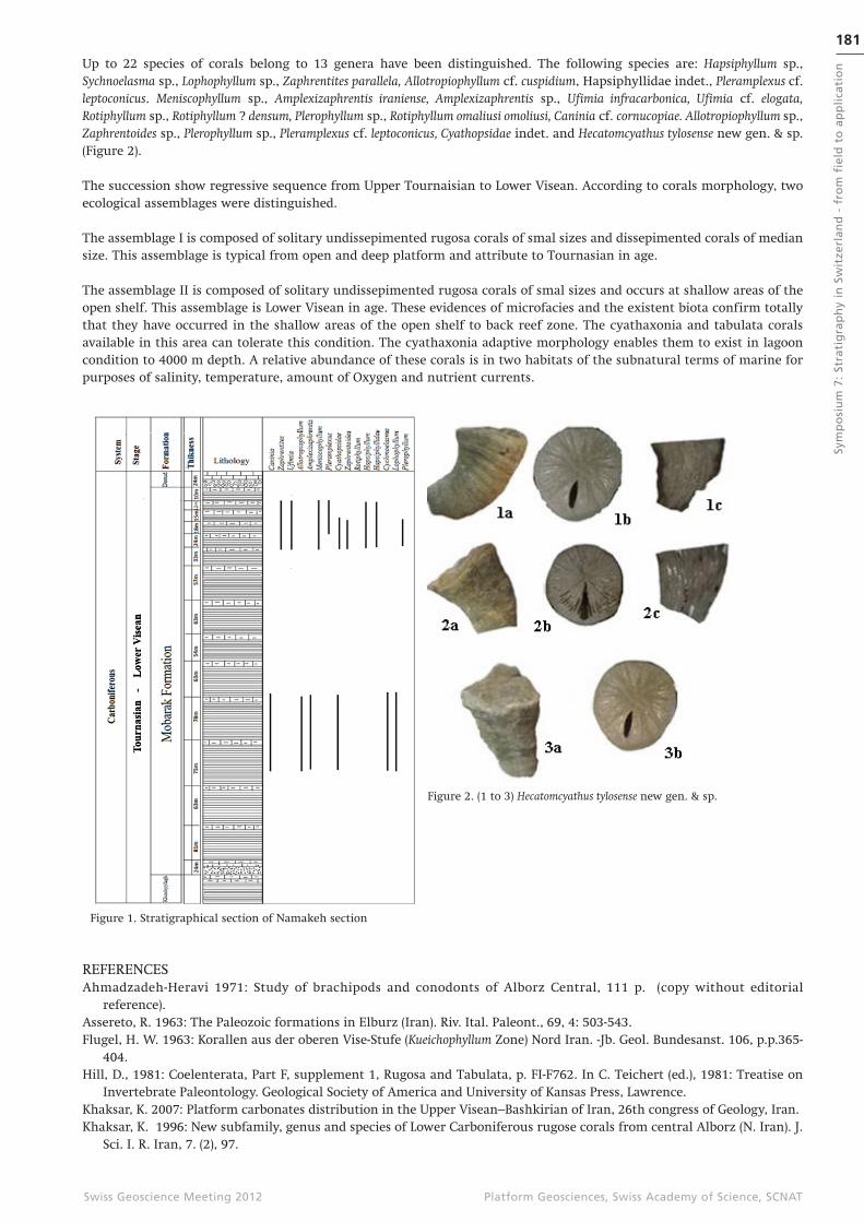
Up to 22 species of corals belong to 13 genera have been distinguished. The following species are: Hapsiphyllum sp., Sychnoelasma sp., Lophophyllum sp., Zaphrentites parallela, Allotropiophyllum cf. cuspidium, Hapsiphyllidae indet., Pleramplexus cf. leptoconicus. Meniscophyllum sp., Amplexizaphrentis iraniense, Amplexizaphrentis sp., Ufimia infracarbonica, Ufimia cf. elogata, Rotiphyllum sp., Rotiphyllum ? densum, Plerophyllum sp., Rotiphyllum omaliusi omoliusi, Caninia cf. cornucopiae. Allotropiophyllum sp., Zaphrentoides sp., Plerophyllum sp., Pleramplexus cf. leptoconicus, Cyathopsidae indet. and Hecatomcyathus tylosense new gen. & sp. (Figure 2).
The succession show regressive sequence from Upper Tournaisian to Lower Visean. According to corals morphology, two ecological assemblages were distinguished.
The assemblage I is composed of solitary undissepimented rugosa corals of smal sizes and dissepimented corals of median size. This assemblage is typical from open and deep platform and attribute to Tournasian in age.
The assemblage II is composed of solitary undissepimented rugosa corals of smal sizes and occurs at shallow areas of the open shelf. This assemblage is Lower Visean in age. These evidences of microfacies and the existent biota confirm totally that they have occurred in the shallow areas of the open shelf to back reef zone. The cyathaxonia and tabulata corals available in this area can tolerate this condition. The cyathaxonia adaptive morphology enables them to exist in lagoon condition to 4000 m depth. A relative abundance of these corals is in two habitats of the subnatural terms of marine for purposes of salinity, temperature, amount of Oxygen and nutrient currents.
Figure 2. (1 to 3) Hecatomcyathus tylosense new gen. & sp.
Figure 1. Stratigraphical section of Namakeh section
REFERENCESAhmadzadeh-Heravi 1971: Study of brachipods and conodonts of Alborz Central, 111 p. (copy without editorial
reference).Assereto, R. 1963: The Paleozoic formations in Elburz (Iran). Riv. Ital. Paleont., 69, 4: 503-543.Flugel, H. W. 1963: Korallen aus der oberen Vise-Stufe (Kueichophyllum Zone) Nord Iran. -Jb. Geol. Bundesanst. 106, p.p.365-
404.Hill, D., 1981: Coelenterata, Part F, supplement 1, Rugosa and Tabulata, p. FI-F762. In C. Teichert (ed.), 1981: Treatise on
Invertebrate Paleontology. Geological Society of America and University of Kansas Press, Lawrence.Khaksar, K. 2007: Platform carbonates distribution in the Upper Visean–Bashkirian of Iran, 26th congress of Geology, Iran.Khaksar, K. 1996: New subfamily, genus and species of Lower Carboniferous rugose corals from central Alborz (N. Iran). J.
Sci. I. R. Iran, 7. (2), 97.
Fig. 3 (a). Sección estratigráfica D-D’ en dirección del rumbo de la sedimentación. (b) Sección sísmica D-D’ 2D.
182Sy
mp
osi
um
7:
Stra
tig
rap
hy
in S
wit
zerl
and
- f
rom
fie
ld t
o a
pp
lica
tio
n
Platform Geosciences, Swiss Academy of Science, SCNATSwiss Geoscience Meeting 2012
P 7.5
Sulfur isotope stratigraphy of Middle to Upper Triassic marine evaporites in the Jura Mountains, Northern Switzerland
Meier Irene1 2, Bernasconi Stefano M.1, Ramseyer Karl3, Brack Peter4, Bläsi Hansruedi3, Wohlwend Stephan1 & Hochuli Peter A.5
1 Geological Institute, ETZ Zürich, Sonneggastrasse 5, 8092 Zürich, Switzerland ([email protected])2 KIBAG Bauleistungen AG, Ablagerungen und Deponie, Seestrasse 404, 8038 Zürich, Switzerland3 Institute of Geological Sciences, University of Bern, Baltzerstrasse 1+3, CH-3012 Bern, Switzerland 4 Department of Earth Sciences, ETH Zürich, Sonneggstrasse 5, 8092 Zürich, Switzerland5 Palaeontological Institute and Museum, University Zürich, Karl Schmid-Strasse 4, CH-8006 Zürich, Switzerland
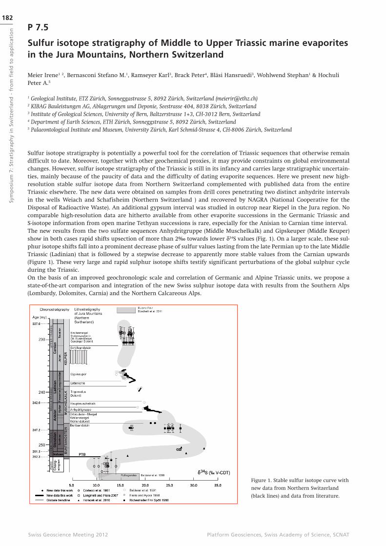
Sulfur isotope stratigraphy is potentially a powerful tool for the correlation of Triassic sequences that otherwise remain difficult to date. Moreover, together with other geochemical proxies, it may provide constraints on global environmental changes. However, sulfur isotope stratigraphy of the Triassic is still in its infancy and carries large stratigraphic uncertain-ties, mainly because of the paucity of data and the difficulty of dating evaporite sequences. Here we present new high-resolution stable sulfur isotope data from Northern Switzerland complemented with published data from the entire Triassic elsewhere. The new data were obtained on samples from drill cores penetrating two distinct anhydrite intervals in the wells Weiach and Schafisheim (Northern Switzerland ) and recovered by NAGRA (National Cooperative for the Disposal of Radioactive Waste). An additional gypsum interval was studied in outcrop near Riepel in the Jura region. No comparable high-resolution data are hitherto available from other evaporite successions in the Germanic Triassic and S-isotope information from open marine Tethyan successions is rare, especially for the Anisian to Carnian time interval. The new results from the two sulfate sequences Anhydritgruppe (Middle Muschelkalk) and Gipskeuper (Middle Keuper) show in both cases rapid shifts upsection of more than 2‰ towards lower d34S values (Fig. 1). On a larger scale, these sul-phur isotope shifts fall into a prominent decrease phase of sulfur values lasting from the late Permian up to the late Middle Triassic (Ladinian) that is followed by a stepwise decrease to apparently more stable values from the Carnian upwards (Figure 1). These very large and rapid sulphur isotope shifts testify significant perturbations of the global sulphur cycle during the Triassic. On the basis of an improved geochronologic scale and correlation of Germanic and Alpine Triassic units, we propose a state-of-the-art comparison and integration of the new Swiss sulphur isotope data with results from the Southern Alps (Lombardy, Dolomites, Carnia) and the Northern Calcareous Alps.
Figure 1. Stable sulfur isotope curve with
new data from Northern Switzerland
(black lines) and data from literature.
183
Sym
po
siu
m 7
: St
rati
gra
ph
y in
Sw
itze
rlan
d -
fro
m f
ield
to
ap
pli
cati
on
Platform Geosciences, Swiss Academy of Science, SCNATSwiss Geoscience Meeting 2012
P 7.6
Using Dickinson’s method for a better understanding of the origin of the Voirons Flysch (Gurnigel nappe, Haute-Savoie, France)
Ragusa Jérémy1, Ospina-Ostios Lina-Maria1 & Kindler Pascal1
1 University of Geneva, Section of Earth and environmental sciences, 1211 Genève 4 ([email protected])
Grain counting of sandstone samples collected from the Voirons f lysch following Dickinson’s model shows that these sandstones originate from a continental area, as sandstones from the other portions of the Gurnigel nappe. Composition variations further demonstrate that it is possible to distinguish distinctive petrofacies within this f lysch. The latter obser-vation contradicts the classic idea that such differentiation was impossible.
Silicoclastics sedimentary successions of the Voirons f lysch in the Gurnigel nappe (Haute-Savoie, France) have not been much studied from a sedimentological and petrographic viewpoint. Therefore, lithological unit descriptions and subdivi-sions are based on empiric criteria (occurrence of sandstones, conglomerates, or marls) rather than on tangible elements. Additionally, field experience demonstrates that it is difficult to observe facies variations. Our study consists in a sedimen-tological, petrographical and mineralogical analysis of this f lysch based on several tools.
In the Chablais Prealps, the Gurnigel nappe is represented by the Voirons f lysch which is exposed in the Voirons and Vouan massifs and some minor reliefs. This f lysch is subdivided into three units: (1) the Voirons sandstones (VS), basically cons-tituted by a thick-bedded sandstone series punctuated with some conglomeratic interbeds; (2) the Vouan conglomerates (VCg) forming metric-thick beds of matrix supported conglomerates with subordinate sandstones; and (3) the Saxel marls (SM) represented by a series of metre-thick marl layers separated by thinly bedded sandstones. This succession is interpre-ted as a turbiditic sequence from intermediate (VS) to proximal (VCg) and possibly distal (SM) facies. Ongoing biostratigra-phic investigations have rejuvenated this f lysch from the Middle Eocene to the Late Eocene - Early Oligocene.
More than 250 thin sections have been elaborated for the three members. Each thin section has been stained in order to differentiate alkaline feldspars, plagioclases and quartz. Counting of 300 points per section was done following the Gazzi-Dickinson protocol. Feldspars and plagiolcases from granite or volcanic lithoclasts have been identified. Other constituents have also been taken into account as extra-counting.
All samples have been classified as quartzo-feldpathic sandstones with variable composition. They are lithoclasts depleted. Most of them plot in the “Stable Craton” and in the “Transitional Continental” fields of the Dickinson ternary diagram. This result is comparable to that obtained from analogous analyses performed in other areas of the Gurnigel nappe and confirms a similar provenance for these sediments.

184Sy
mp
osi
um
7:
Stra
tig
rap
hy
in S
wit
zerl
and
- f
rom
fie
ld t
o a
pp
lica
tio
n
Platform Geosciences, Swiss Academy of Science, SCNATSwiss Geoscience Meeting 2012
P 7.7
The last deglaciation of the northern Alpine Foreland: Evidence from the Reuss Glacier
Reber Regina 1, Akçar Naki 1, Ivy-Ochs Susan 2, Tikhomirov Dmitry1, Burkhalter Reto3,. Zahno Conradin 4, Lüthold Aron 5, Kubik Peter W. 6, Vockenhuber Christof2 and Schlüchter Christian 1
1 Institut für Geologie, Universität Bern, CH-3012 Bern, ([email protected]), 2 ETH Zurich, Laboratory of Ion Beam Physics (LIP), CH-8093 Zurich3 Landesgeologie, Bundesamt für Landestopografie swisstopo, CH-3084 Wabern, 4 Sunnebergliweg 6, CH-6403 Küssnacht, 5 CSD Ingenieure AG, Postfach, CH-6460 Altdorf, 6 Paul Scherrer Institut, c/o Institut für Teilchenphysik, ETH Hönggerberg, CH,8093 Zürich
The Last Glacial Maximum (LGM) advance of the Reuss glacier to the northern Alpine Foreland built lateral moraines on the slopes of Mount Rigi (Canton of Schwyz) and terminal moraines at its frontal position near Lenzburg (Canton of Aargau). In order to establish the timing of deglaciation of the Reuss glacier starting after the LGM, we exposure dated erratic boulders with cosmogenic 10Be and 36Cl. On LGM- terminal position of the Reuss glacier, we sampled two erratic boulders: “Grosser Römerstein” and “Kleiner Römerstein”. We also collected samples from the lateral Alpine border po-sition at the Rigi. The minimum exposure ages on the terminal position at around 22 ka and on its lateral maxima posi-tion at around 20 ka show that the beginning deglaciation of the Reuss glacier is comparable with other lobes in the northern Alpine Foreland. An erratic boulder next to the “Erdmannlistein” (Wohlen, AG) which is situated at approximate-ly 12 km in behind the maximal extent yielded the first exposure age from a retreat stadial position (“Stetten Stadium” sensu Jäckli 1966) in the northern Alpine Foreland, which indicates a deglaciation age of no later than around 19 ka. Based on our results, the melt back from the position in Wohlen at around 19 ka ago up to the high Alpine valley at the positi-on of the next advance (Gschnitz s.l.) must have been extremely fast.
REFERENCESGraf, H.R., 2009. Stratigraphie von Mittel- und Spätpleistozän in der Nordschweiz. – Beiträge zur Geologischen Karte der
Schweiz, 168, Bundesamt für Landestopografie swisstopo, Wabern.Jäckli, H., 1966. Blatt 1090 Wohlen.- Geol. Atlas Schweiz 1:25 000, Erläut. 50. Bundesamt für Landestopographie: Wabern-
Bern.
185
Sym
po
siu
m 7
: St
rati
gra
ph
y in
Sw
itze
rlan
d -
fro
m f
ield
to
ap
pli
cati
on
Platform Geosciences, Swiss Academy of Science, SCNATSwiss Geoscience Meeting 2012
P 7.8
The Middle Triassic (Anisian) marine transgression in the Tödi area, Central Switzerland
Rebetez Daniel, Ramseyer Karl
Institut für Geologie, Universität Bern, Baltzerstrasse 1+3, CH-3012 Bern
During the basal Triassic, a shallow sea f looded the crystalline basement in central Switzerland. The knowledge on this transgression, i.e., stratigraphic allocation, depositional environment and paleogeographic setting, has been refined by numerous geologists since the end of the 18th century (e.g., Brunnschweiler, 1948; Widmer, 1949). Still, chronology, dy-namics and direction(s) of this transgression remain unclear. First efforts based on palynological data (Gisler et al., 2007) indicated a marine transgression direction from the Tethys towards the Jura Mountains at lowermost Anisian time.
This study presents four different stratigraphic sections in the Tödi area, i.e., Limmernsee, Val Punteglias, Obersand and Hüfihütte, where lack of vegetation, well-exposed rocks and little tectonic deformation allowed detailed logging. The first sediments deposited on the weathered crystalline basement consist of conglomerats and sandstones with a fining-up trend. Numerous sedimentary structures such as ripple marks or channels can be observed in this siliciclastic unit. Following-up section, the clastic beds become thinner and dolomite layers appear randomly until they dominate. In the uppermost 20 m of the sequence, dolomite beds become massive and show a well-developed stacking pattern. The tops of the Triassic sections are erosive surfaces followed by black shales of Lias to Dogger in age. The thickness of these sedimen-tary deposits vary from one section to another. The Val Punteglias section is 54 m and thicker than the Limmernsee section (45 m), the Obersand section (32 m) and the Hüffihütte section (27m). Thus, the Triassic deposits thin towards the north and the west. Facies and microfacies determinations, sedimentary structure analyses as well as stable isotope analyses (d13C, d18O) have been carried out. Preliminary results show that the sedimentary record displays several depositional sequences implying that high-frequency relative sea-level f luctuations were superimposed onto the general transgressive trend. These obser-vations allow to correlate the four locations and to give indications about the depositional system and paleotopography.
Additional palynofacies analyses will be performed to reinforce these correlations and to determine more precisely the timing of the transgression. Several other sections will be logged in the Windgällen area (Ronenegg) and close to Erstfeld (Scheidnössli). This last section has already been well documented and will act as an anchor for the corelation. In a next step, these results will be compared with those of the Weiach borehole (Jura mountains) to get a better under-standing on the Alpine realm at middle Triassic times.
REFERENCESBrunnschweiler, R.O. 1948: Beiträge zur Kenntnis der Helvetischen Trias östlich des Klausenpass. Mitteilung aus dem
Geologischen Institut der Eidgenössischen Technischen Hochschule und der Universität Zürich, Serie C, 33.Gisler, Ch., Hochuli, P.A., Ramseyer, K., Bläsi, H.R. & Schlunegger, F. 2007: Sedimentological, and palynological constraints
on the basal Triassic sequence in Central Switzerland. Swiss Journal of Geosciences 100, 263-272.Widmer, H. 1949: Zur Geologie der Tödigruppe. A.-G. Buchdruckerei Wetzikon und Rüti, 98.
186Sy
mp
osi
um
7:
Stra
tig
rap
hy
in S
wit
zerl
and
- f
rom
fie
ld t
o a
pp
lica
tio
n
Platform Geosciences, Swiss Academy of Science, SCNATSwiss Geoscience Meeting 2012
7.9
From “black shales” to red beds in the northern Helvetic Seewen Formation (Cenomanian – Turonian)
Wohlwend Stephan1 & Weissert Helmut1
1Geological Institute, ETH Zurich, Sonneggstrasse 5, CH-8092 Zurich ([email protected])
Several Cenomanian – Turonian pelagic limestone sections were studied at high resolution to gain a better understanding of the highly variable sedimentation of the Late Cretaceous along the northern Tethyan margin. Two expanded sections in the Churfirsten Mountains (Chäserrugg, 32 m and Strichboden, 8 m) and another in the Alpstein (Kamor, 18 m) were sampled in 10 cm spacing. Both sections belong to the northern Helvetic Seewen Formation (Churfirsten-Säntis nappe). Samples were analysed for stable carbon- and oxygen-isotopes.
Westermann et al. (2010) showed that the onset of the d13C positive excursion of the Ocean Anoxic Event 2 (OAE2) is cha-racterised by glauconite grains and even a small hiatus. The same characteristic layer can also be found 40km more to the east in the Churfirsten. The condensed beds comprise the first d13C excursion of the OAE2 (peak “a” 4.1‰) of the positive excursion. There are also some karstic features visible, which were sometimes filled by a glauconite-quarz sand. The follo-wing darker and more marly interval can be seen as evidence deposition near or within an expanded oxygen minimum zone. This succession can be traced into the Alpstein area (Zwinglipass) and further to the location “Kamor” (Appenzell) and into the Vorarlberg region. In the Kamor section, the condensed interval shows a d13C value of 4.8‰. An 80cm thick glauconite sand layer, the so called lower “Götzis bed” (Föllmi and Ouwehand, 1987), forms the top of this condensed in-terval. Based on C-isotope data, this condensed interval is correlated with OAE2.
The new C-isotope stratigraphy established in eastern Switzerland contrasts with the stratigraphy proposed by Westermann et al. (2010). These authors propose that sediments corresponding with OAE2 have an overall thickness of the about 11 meters. This study shows that OAE2 has a thickness of only 2-3 meters in the Seewen Limestone successions of Eastern Switzerland. A chemostratigraphic correlation of the Latest Cenomanian and Earliest Turonian intervals is possible if sampling resolution is in the order of around 10 centimeters.
Roughly 10m above the described d13C excursion the sediment colour of the Seewen limestone becomes reddish. The red variety of the Seewen Fm consists of several red intervals. The first and most distinct Oceanic Red Bed (CORB) occurs al-ways in the H. Helvetica total range zone (Bolli, 1944). This Oceanic Red Bed was also described by Neuhuber et al. (2007) in the Ultrahelvetic units of the Eastern Alps of Austria and Bavaria. With the new chemostratigrapy these 3 CORB’s intervals can be linked with sharp negative shifts of the d13C record of the Middle and Late Turonian.
REFERENCESBolli, H. 1944: Zur Stratigraphie der Oberen Kreide in den höheren helvetischen Decken. Eclogae geologicae Helvetiae 37
(2), 218-328.Föllmi, K.B. & Ouwehand, P.J. 1987: Garschalla-Formation und Götzis-Schichten (Aptian-Coniacian): Neue stratigraphische
Daten aus dem Helvetikum der Ostschweiz und des Vorarlbergs. Eclogae geologicae Helvetiae 80, 141e191.Neuhuber, S., Wagreich, M., Wendler, I. & Spötl, C. 2007: Turonian oceanic red beds in the Eastern Alps: concepts for
paleoceanograpic changes in the Mediterranean Tethys. Palaeogeography, Palaeoclimatology, Palaeoecology 251, 222–238.
Westermann, S., Caron, M., Fiet, N., Fleitmann, D., Matera, V., Adatte, T. & Föllmi, K.B. 2010: Evidence for oxic conditions during oceanic anoxic event 2 in the northern Tethyan pelagic realm. Cretaceous Research, 31, 500-514.

187
Sym
po
siu
m 7
: St
rati
gra
ph
y in
Sw
itze
rlan
d -
fro
m f
ield
to
ap
pli
cati
on
Platform Geosciences, Swiss Academy of Science, SCNATSwiss Geoscience Meeting 2012