access design and traffic requirements
TRANSCRIPT

Access Design and Traffic Requirements
8

Chapter 8—Access Design and Traffic Requirements December 8, 2020 Table of Contents
Adams County Development Standards and Regulations 8-i
CHAPTER 8—ACCESS DESIGN AND TRAFFIC REQUIREMENTS Table of Contents
8-01 ACCESS REQUIREMENTS AND CRITERIA ....................................................... 1 8-01-01 General ................................................................................................ 1 8-01-02 Required Design Submittals .................................................................. 1 8-01-03 Criteria for Access onto Adams County Roadways ................................. 2 8-01-04 Sight Distance ....................................................................................... 8 8-01-05 Number of Openings ............................................................................ 8 8-01-06 Criteria for Curb Openings and Driveways ............................................. 8 8-01-07 Auxiliary Lanes ................................................................................... 13 8-01-08 Criteria for Auxiliary Lanes .................................................................. 13 8-01-08-01 Collectors, Minor and Principal Arterials .................................................. 14 8-01-08-01-01 Functional Characteristics and Category Assignment Criteria ................. 14 8-01-08-01-02 Access Granting Criteria Including Category Related Access Location,
Operation and Design Standards .............................................................. 14 8-01-08-02 Auxiliary Lane Requirements .................................................................... 14 8-01-08-03 Design Components .................................................................................. 18 8-01-08-04 Deceleration and Acceleration Design Criteria ......................................... 19 8-01-08-05 Storage Lengths ........................................................................................ 21 8-01-08-06 Additional Auxiliary Lane Design Standards ............................................. 21 8-01-09 Bypass Lanes ...................................................................................... 21 8-01-10 Unpermitted Access ........................................................................... 22
8-02 GUIDELINES FOR TRAFFIC IMPACT STUDIES ............................................... 23 8-02-01 General .............................................................................................. 23 8-02-02 Requirements for Traffic Impact Studies ............................................. 23 8-02-03 Preliminary Scoping Meeting .............................................................. 24 8-02-04 Responsibilities for Traffic Impact Studies ........................................... 25 8-02-05 Planning Horizons and Roadway Network Assumptions ...................... 26 8-02-06 TIS Report Requirements .................................................................... 26 8-02-06-01 Summary ................................................................................................... 26 8-02-06-01-01 Project Overview ....................................................................................... 27 8-02-06-01-02 Site Location and Study Area Boundaries ................................................. 27 8-02-06-01-03 Description of Site ..................................................................................... 27 8-02-06-01-04 Existing and Proposed Uses in Vicinity of Site ........................................... 28 8-02-06-01-05 Existing and Committed Transportation Network .................................... 28 8-02-06-02 Existing Traffic Conditions ......................................................................... 28
Chapter 8—Access Design and Traffic Requirements Table of Contents December 8, 2020
8-ii Adams County Development Standards and Regulations
8-02-06-03 Future Traffic Conditions Without Proposed Development ..................... 29 8-02-06-04 Proposed Project Traffic ........................................................................... 30 8-02-06-04-01 Trip Generation ......................................................................................... 30 8-02-06-04-02 Adjustments to Trip Generation Rates ...................................................... 32 8-02-06-04-03 Trip Generation Budget ............................................................................. 32 8-02-06-04-04 Trip Distribution ........................................................................................ 33 8-02-06-04-05 Project Trip Assignment ............................................................................ 33 8-02-06-05 Future Traffic Forecasts With the Proposed Development ...................... 34 8-02-06-06 Project Impacts ......................................................................................... 34 8-02-06-06-01 Generalized Daily Traffic Volume Level of Service .................................... 34 8-02-06-06-02 Peak Hour Intersection Level of Service .................................................... 34 8-02-06-06-03 Traffic Signals and Access Locations ......................................................... 35 8-02-06-06-04 Turn Lane Storage Requirements .............................................................. 35 8-02-06-06-05 Sight Distance ........................................................................................... 35 8-02-06-06-06 Acceleration or Deceleration Lanes .......................................................... 35 8-02-06-07 Special Analysis/Issues .............................................................................. 36 8-02-06-08 Mitigation Measures/Recommendations ................................................. 36 8-02-07 Requirements for Updating Existing Traffic Impact Studies .................. 37
List of Figures Figure 8.1—Intersection Separations ............................................................................................. 7 Figure 8.2—Information Guide to Basic Auxiliary Lane Elements ................................................ 21
List of Tables Table 8.1—General Access Issues ................................................................................................... 2 Table 8.2—Criteria for Access onto Major Arterials ....................................................................... 4 Table 8.3—Criteria for Access onto Minor Arterials ....................................................................... 5 Table 8.4—Criteria for Access onto Collectors and Local Streets .................................................. 6 Table 8.5—Number of Access Points .............................................................................................. 8 Table 8.7—Principles for Curb Openings and Driveways ............................................................. 11 Table 8.7—Principles for Curb Openings and Driveways (continued) ......................................... 12 Table 8.8—Roadway Improvements Thresholds .......................................................................... 16 Table 8.9—Components of Speed Change Lane Length............................................................... 18 Table 8.10—Warrants for Auxiliary Lanes .................................................................................... 19 Table 8.11—Accelaration/Deceleration Lane Design Criteria ...................................................... 19 Table 8.12—Grade Adjustments for Acceleration Lanes .............................................................. 20 Table 8.13—Grade Adjustments for Deceleration Lanes ............................................................. 20 Table 8.14—Auxiliary Lane Storage Lengths ................................................................................ 21 Table 8.15—Traffic Impact Study Requirement ........................................................................... 24 Table 8.16—Threshold Capacity ................................................................................................... 29 Table 8.17—Traffic Generation Summary Sheet .......................................................................... 31

Chapter 8—Access Design and Traffic Requirements December 8, 2020 Table of Contents
Adams County Development Standards and Regulations 8-iii
Table 8.18—Requirements for Updating an Existing TIS .............................................................. 38 Table 8.19—Recommended Improvements Summary Sheet ...................................................... 39


Chapter 8—Access Design and Traffic Requirements December 8, 2020 Access Requirements and Criteria
Adams County Development Standards and Regulations 8-1
Chapter 8—ACCESS DESIGN AND TRAFFIC REQUIREMENTS
Presented in this chapter are minimum requirements and technical criteria for the analysis and design of access locations to and from county roadways with the intent of providing a safe, orderly, and continuous traffic/pedestrian movement. Traffic is a regional feature that affects all governmental jurisdictions and all parcels of property. All applications submitted to the County for land being developed commercially, industrially, or as a subdivision, and/or as part of an existing subdivision desiring access to a county roadway will require some form of access and traffic analysis and appropriate design. The level of detail and specific requirements for each of these submittals will be outlined within this chapter.
8-01 ACCESS REQUIREMENTS AND CRITERIA
8-01-01 GENERAL The county has adopted the following design standards and criteria for traffic management and should be used in the analysis and design of all new or modified access point locations. However, the County reserves the right to issue and enforce more stringent criteria should adverse or unsafe conditions exist. Also, conditions may arise where the minimum standards presented within this chapter are either inappropriate or cannot be justified economically. In these special cases, the County may issue a variance. All designs that vary from the standards and criteria presented in this chapter, shall obtain approval from the County prior to completing construction plans or Traffic Impact Study (TIS). Standards and technical criteria not specifically addressed in this chapter shall follow the appropriate provisions outlined in the 2001 AASHTO, A Policy on Geometric Design of Highways and Streets (“Green Book”) and/or the Colorado State Highway Access Code. In addition, County Standards are presented in Appendix A. It is important to note that County Standards may supersede the AASHTO criteria. In the event that the AASHTO criteria are revised, the latest edition shall be used.
8-01-02 REQUIRED DESIGN SUBMITTALS Project Plans and TIS submitted to the County for review shall contain a detailed analysis and comprehensive circulation design in accordance with these criteria and other applicable standards (local, state, and federal). Prior to receiving approval, the Project Plans and TIS must be sealed by a Colorado Registered Professional Engineer who has extensive knowledge of the project being submitted for review. Documents submitted without being sealed or by a party not responsible for the work, will not be reviewed. Section 8-02 presents the minimum level of TIS to be prepared and submitted to the County for approval. Based on the application and the size of project being

Chapter 8—Access Design and Traffic Requirements Access Requirements and Criteria December 8, 2020
8-2 Adams County Development Standards and Regulations
submitted, the level of analysis and design detail required varies and can be determined by the checklist attached to the application and/or by contacting the County. All required information is to be submitted for County review prior to receiving an approved application or permit. Applicants are encouraged to prepare the required submittals with as much detail as possible to minimize possible confusion and cut down on overall processing time.
Table 8.1—General Access Issues
Objective Criteria outlined in this chapter should be viewed as the minimum requirements for the design of entrances and exits and determining the proper location of access point(s) onto any of the existing or proposed county roads.
Quality All work done under this permit shall be performed to the satisfaction of the County.
Factors Reviewed The factors reviewed with each access application include: speed of the highway, sight distance, existing or potential safety concerns, existing traffic on the highway, intersection spacing and the projected vehicular use of the site.
Traffic Impact Study (TIS)
• In reviewing a site, the County may require an applicant to prepare a Traffic Impact Study (TIS) for review and approval by the County to determine the impact the development may have on the adjacent road systems.
• The TIS should address the impact of the additional traffic generated by the development and propose appropriate improvements to mitigate that impact.
• Guidelines for the preparation of the TIS are included as part of the applicable Permit Application.
Hydraulic Impact
• The engineer may need to submit the information for review by the County to determine the hydraulic impact to the existing roadway drainage system.
• Based on the submitted information, the engineer may be required to supply additional hydraulic computations for review and approval by the County.
• A proper Storm Drainage Study (including project plans) must be reviewed and approved by the County and implemented by the Permittee.
• Standards and technical criteria are included in Chapter 9 of this document.
Implementation
• No person shall construct any access providing direct movement to or from any county maintained roadway without obtaining approval from the County.
• County approval and the appropriate permits necessary for construction shall be issued only in compliance with the policies outlined in this chapter. Under no circumstances shall access be allowed or permitted if it is detrimental to the public health, welfare, and safety.
• Vehicular access to or from property adjoining a county roadway shall be provided to the general street system, unless, such access has been acquired by a public authority. Police, fire, ambulance, and other emergency stations shall have a right to direct access to county roadways. Direct access from a development project to the roadway shall be permitted only if the proposed access meets the purpose and requirements of this chapter.
8-01-03 CRITERIA FOR ACCESS ONTO ADAMS COUNTY ROADWAYS All new or modified access locations in Adams County shall meet the requirements of the Colorado Department of Transportation and information presented in this chapter. Where possible, the access may also comply with the requirements of the

Chapter 8—Access Design and Traffic Requirements December 8, 2020 Access Requirements and Criteria
Adams County Development Standards and Regulations 8-3
Denver Regional Council of Governments. Refer to Table 8.2, Table 8.3, and Table 8.4 for county access criteria onto major and minor arterials, major and minor collectors, and local streets. All new commercial and industrial developments shall provide connectivity to adjoining commercial and industrial developments, unless otherwise determined by the Community and Economic Development Department. Access to State Highways is governed by the State Highway Access Code and the engineer must follow appropriate criteria and standards.
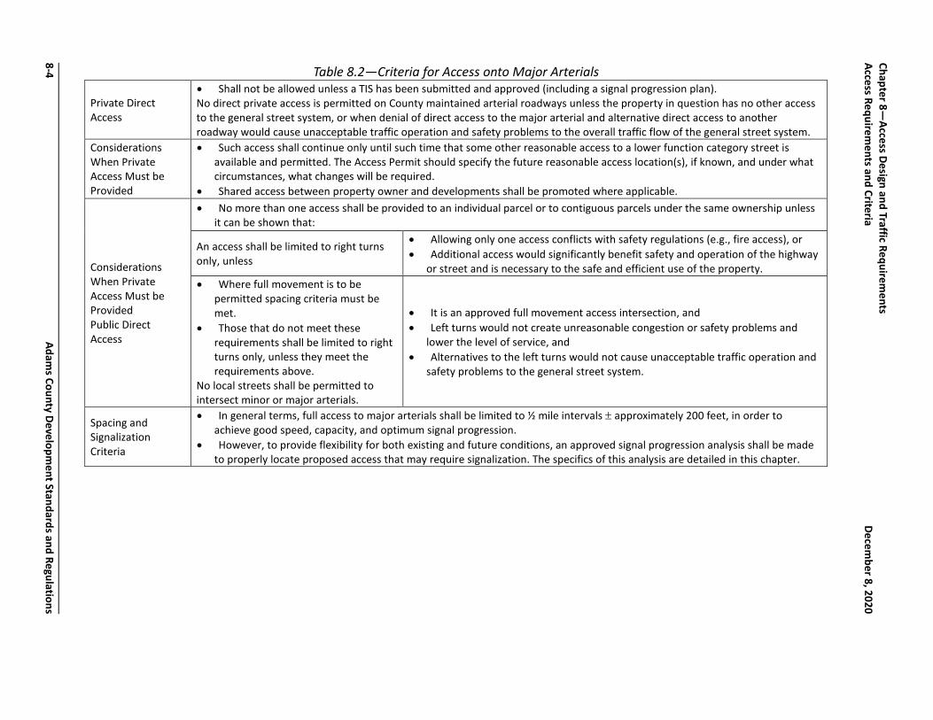
Table 8.2—Criteria for Access onto Major Arterials
Private Direct Access
• Shall not be allowed unless a TIS has been submitted and approved (including a signal progression plan). No direct private access is permitted on County maintained arterial roadways unless the property in question has no other access to the general street system, or when denial of direct access to the major arterial and alternative direct access to another roadway would cause unacceptable traffic operation and safety problems to the overall traffic flow of the general street system.
Considerations When Private Access Must be Provided
• Such access shall continue only until such time that some other reasonable access to a lower function category street is available and permitted. The Access Permit should specify the future reasonable access location(s), if known, and under what circumstances, what changes will be required.
• Shared access between property owner and developments shall be promoted where applicable.
Considerations When Private Access Must be Provided Public Direct Access
• No more than one access shall be provided to an individual parcel or to contiguous parcels under the same ownership unless it can be shown that:
An access shall be limited to right turns only, unless
• Allowing only one access conflicts with safety regulations (e.g., fire access), or • Additional access would significantly benefit safety and operation of the highway
or street and is necessary to the safe and efficient use of the property. • Where full movement is to be
permitted spacing criteria must be met.
• Those that do not meet these requirements shall be limited to right turns only, unless they meet the requirements above.
No local streets shall be permitted to intersect minor or major arterials.
• It is an approved full movement access intersection, and • Left turns would not create unreasonable congestion or safety problems and
lower the level of service, and • Alternatives to the left turns would not cause unacceptable traffic operation and
safety problems to the general street system.
Spacing and Signalization Criteria
• In general terms, full access to major arterials shall be limited to ½ mile intervals ± approximately 200 feet, in order to achieve good speed, capacity, and optimum signal progression.
• However, to provide flexibility for both existing and future conditions, an approved signal progression analysis shall be made to properly locate proposed access that may require signalization. The specifics of this analysis are detailed in this chapter.
8-4 Adam
s County Development Standards and Regulations
Chapter 8—Access Design and Traffic Requirem
ents
Access Requirements and Criteria
December 8, 2020

Table 8.3—Criteria for Access onto Minor Arterials
Private Direct Access
Generally, shall not be allowed onto a minor arterial. Private direct access onto a minor arterial may be permitted: • If it does not have the potential for signalization. • If it has the potential for signalization, if it meets the signal spacing requirements for intersection public streets stated below
and does not interfere with the location, planning, and operation of the general street system and access to nearby properties. • If no more than one access is provided to an individual parcel or to contiguous parcels under the same ownership unless it
can be shown that additional access would be beneficial to the safety and operation of the highway and to the safety of public. Access may continue until such time that some other reasonable access to a lower functional category street or highway is available. A traffic circulation plan, and/or street construction plans with phasing should specify under what circumstances the changes will be required. Subdivisions should be designed to provide for alternative access at a future date.
Public Direct Access
• Where left turns are to be permitted must meet the signal spacing criteria. • Those that do not meet these requirements shall be limited to right turns only, unless they meet the requirements stated in
Table 8.2. • No local streets shall be permitted to intersect minor or major arterials.
Spacing and Signalization Criteria
• In general terms, full access to minor arterials shall be limited to one-quarter mile intervals, ± approximately 100 feet, in order to achieve good speed, capacity, and optimum signal progression
• In urban areas and developing areas where higher traffic volumes are present, a spacing of one-half mile (± 200 feet for rural highway sections) for all accesses should be maintained. This spacing is desirable to achieve good speed, highway capacity and optimum turning progression.
• However, to provide flexibility for both existing and future conditions, an approved signal progression analysis shall be made to properly locate proposed access that may require signalization. The specifics of this analysis are detailed in this chapter.
Adams County Developm
ent Standards and Regulations 8-5
Chapter 8—
Access Design and Traffic Requirements
December 8, 2020
Access Requirements and Criteria

Table 8.4—Criteria for Access onto Collectors and Local Streets Collectors Local Streets
Private Access
Shall be governed by the Curb Opening and Driveway Criteria in Section 8-01-06 • Single-family residence and business access to collectors is not
permitted unless access to a lower function category street is not available.
• Access shall not be provided to an individual or to contiguous parcels under the same ownership unless it can be shown that additional access would not be detrimental the safety and operation of the highway, or allowing only one access would be in conflict with local safety regulations, and the additional access would not be detrimental to public health, safety and welfare.
Direct access will be provided to each parcel or to contiguous parcels when there will not be any significant safety or operational problems and the spacing meets the access spacing requirements of this policy.
Public Streets
• Shall intersect collector not closer than 330 feet (minor collector) and 660 feet (major collector) from each other (centerline to centerline)
• The closest street intersection to an arterial shall be 330 feet (minor collector) and 660 feet (major collector) from the arterial (ROW line of arterial to centerline of local street)
• On minor collectors with an ultimate projected traffic volume of less than 2500 vpd, intersection spacing may be 250 feet (centerline to centerline) (for first intersection from an arterial; 210’ centerline to ROW of arterial).
• Should not intersect local roadways closer than 150 feet from each other (centerline to centerline).
• On a local street, the closest intersection to a collector street shall be at least 200 feet (centerline to centerline)
• To an arterial street, the closest intersection shall be 200 feet (arterial ROW line to local street centerline)
• See Figure 8.1.
Spacing
• In urban and developing areas where higher traffic volumes are present or growth is expected in the future, (and for rural highways) access spacing shall be at the 1700-foot intervals.
• Spacing of all major intersecting public streets, roads, highways and other major accesses should be on a minimum of 600-foot intervals.
• For those rural highway sections, spacing of all major intersecting public streets, roads, highways and other major accesses should be on a minimum of 300-foot intervals.
• Public access in urban growth areas spacing shall be to city specifications and may be less than 300 feet.
• Other accesses shall use lot lines for spacing requirements.
8-6 Adam
s County Development Standards and Regulations
Chapter 8—Access Design and Traffic Requirem
ents
Access Requirements and Criteria
December 8, 2020

Chapter 8—Access Design and Traffic Requirements December 8, 2020 Access Requirements and Criteria
Adams County Development Standards and Regulations 8-7
Figure 8.1—Intersection Separations

Chapter 8—Access Design and Traffic Requirements Access Requirements and Criteria December 8, 2020
8-8 Adams County Development Standards and Regulations
8-01-04 SIGHT DISTANCE Sight distance for curb openings to private property shall consist of a sight triangle conforming to the requirements of Chapter 7.
8-01-05 NUMBER OF OPENINGS All additional access points to properties shall be approved by Adams County engineering staff. Applicant shall provide Adams County a scaled site plan showing the proposed location of the new access point, the proposed width of the access point, and the distance of the access point from the property boundary lines and any existing access location. Refer to Table 8.5 for the number of access points to residential, commercial, and industrial property.
Table 8.5—Number of Access Points
Residential Single and Multiple-Family Dwellings
Shall be allowed a maximum of two access points for the roadway of primary frontage and, one additional access point onto any additional ‘local’ roadways adjacent to the property. *
Commercial and Mixed-Use
Less than 150’ of frontage and located mid-block
Limited to one access point per property owner. Shared access among adjacent property owners is strongly encouraged. An exception may be granted where a building is constructed in the middle of a lot and parking is provided for on each side of the building.
More than 150’ of frontage
A second access point may be allowed where there is sufficient frontage to provide for min. and max. design requirements. *
Located on a corner One access to each street may be permitted * Service Station Located on a corner One access to each street may be permitted *
Industrial Access shall be determined on a case-by-case basis. The county shall consider good traffic engineering practice and the information provided by the applicant in the TIS accompanying the submittal.
* Additional access may not be permitted for roads classified as collectors or arterials
8-01-06 CRITERIA FOR CURB OPENINGS AND DRIVEWAYS Certain control values for curb openings and driveways require minimum dimensions in some instances and maximum values for other dimensions. The design of curb openings and driveways within the range of these dimensions will provide for good service on the part of the motorist using the driveway while and minimizing the interference to the traffic using the street. By controlling the location and width of openings or driveways along the street, it will be possible to avoid or eliminate long open stretches where motorists can indiscriminately drive onto the street. The width of opening established in this chapter is based on studies, which indicate the various

Chapter 8—Access Design and Traffic Requirements December 8, 2020 Access Requirements and Criteria
Adams County Development Standards and Regulations 8-9
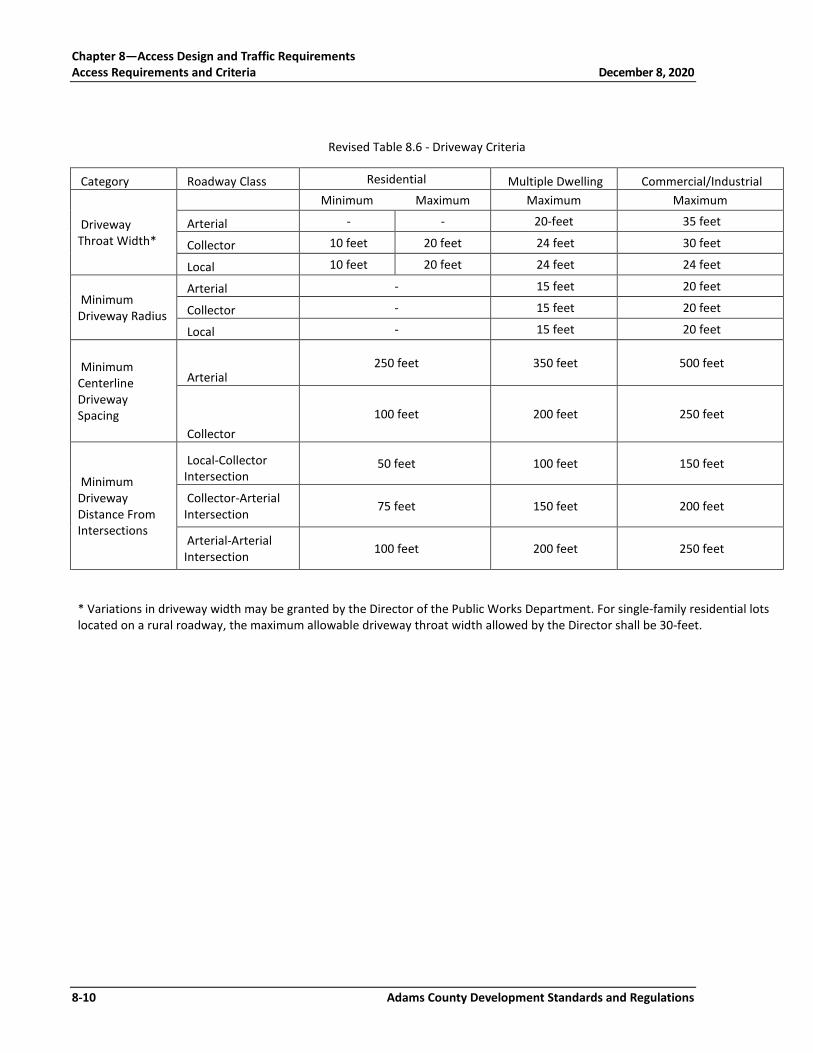
width openings will accommodate vehicles of maximum size authorized on county streets and roadways. In case of conflict between requirements in the various sections of this chapter, the more restrictive condition will normally apply. Refer to Table 8.7 for general design and planning principles regarding curb openings/driveway width, sight distance, public-improvements, driveway approaches, rural road access from private property, and access to roadways with no curb and gutter, and maintenance. Maintenance of the access and drainage improvements within County right-of-way shall be the responsibility of the adjacent property owner. Refer to Table 8.5 for other general requirements regarding number of curb openings permitted, entrance angle, minimum space between openings, joint entrance, access approaches, parcel of land with direct access, use of an existing access to county ROW changes or change in the use of the property. Refer to Table 8.6 for other minimum driveway criteria.
Chapter 8—Access Design and Traffic Requirements Access Requirements and Criteria December 8, 2020
8-10 Adams County Development Standards and Regulations
Revised Table 8.6 - Driveway Criteria
Category Roadway Class Residential Multiple Dwelling Commercial/Industrial
Driveway Throat Width*
Minimum Maximum Maximum Maximum
Arterial - - 20-feet 35 feet
Collector 10 feet 20 feet 24 feet 30 feet
Local 10 feet 20 feet 24 feet 24 feet
Minimum Driveway Radius
Arterial - 15 feet 20 feet
Collector - 15 feet 20 feet
Local - 15 feet 20 feet
Minimum Centerline Driveway Spacing
Arterial 250 feet 350 feet 500 feet
Collector 100 feet 200 feet 250 feet
Minimum Driveway Distance From Intersections
Local-Collector Intersection
50 feet 100 feet 150 feet
Collector-Arterial Intersection 75 feet 150 feet 200 feet
Arterial-Arterial Intersection 100 feet 200 feet 250 feet
* Variations in driveway width may be granted by the Director of the Public Works Department. For single-family residential lots located on a rural roadway, the maximum allowable driveway throat width allowed by the Director shall be 30-feet.

Chapter 8—Access Design and Traffic Requirements December 8, 2020 Access Requirements and Criteria
Adams County Development Standards and Regulations 8-11
Table 8.7—Principles for Curb Openings and Driveways
Opening or Driveway Width
• The opening should handle the anticipated traffic volume and character of traffic, as well as being within the limits specified for the type of property development.
• Total curb opening length on a street for accesses to a commercial or industrial property shall not exceed 40% of the property frontage. Individual curb opening not to exceed those given in Table 8.6 - Driveway Criteria.
• The controls established for curb openings and driveways shall apply to existing and new streets.
Sight Distance
• All openings for driveways shall be located at the point of optimum sight distance along the street. • For openings and driveways to commercial establishments and service stations, provide a space reasonably cleared from
obstruction to allow drivers entering the property sufficient sight distance for proper and safe movements. • Entrance angles for all driveway approaches shall be 90° ± 10° to the centerline of the street. • The profile of a driveway approach and the grading of the adjacent area shall allow a driver in a vehicle located on the driveway
outside the traveled portion of the street to see a sufficient distance in both directions to avoid a hazardous traffic situation when entering the street. Within the ROW, maximum grades shall be limited to 8% for single-family residential access. All other access shall be limited to a maximum of 2% grade.
Public Improvements
• Any adjustments which must be made to utility poles, street light standards, fire hydrants, catch basins or intakes, traffic signs and signals, or other public-improvements or installations which are necessary as the result of the curb openings or driveways shall be accomplished without any cost to the County.
• Any curb opening or driveway, which has been abandoned, shall be restored by the property owner except where such abandonment has been made at the request of, or for the convenience of the County.
• The property owner shall perform maintenance for driveways. Entrance/Exit Driveway Approaches
• Shall be appropriately signed by, and at the expense of, the property owner. • The property owner will be required to provide some means of ensuring that the motorists will use the driveway either as an
entrance only or an exit only, but not both.
Access Surfacing
• Asphalt surfacing of the access shall be required when the roadway is paved. • Accesses shall be paved from edge of pavement to the ROW line. Surface material adjacent to the ROW, within private property,
shall not create sediment tracking onto public roads. • Surfacing materials shall be specified according to county standard presented in Chapter 7 and the conditions and future use of
the access and abutting roadway.

Table 8.7—Principles for Curb Openings and Driveways (continued)
Rural Road Access from Private Property
• New driveway accesses from private property to an existing graveled county road shall be required to install a minimum of 6” of compacted Class 6 aggregate base course or equivalent material from the ROW line to the edge of the traveled roadway.
• The minimum width of the driveway within the ROW shall be as presented in Table 8.2. • Based on drainage analysis, a properly sized culvert with flared end sections shall be required at the established ditch flowline. A
sketch plan of the installation must be submitted with the culvert permit application (see Chapter 9 for Storm Drainage design requirements).
• Culverts are to be installed as necessary for residential and commercial driveways to ensure positive drainage is maintained.
Access to Roadways with No Curb and Gutter
Private drive access to local, collector or arterial roadways that have no curb and/or gutter improvements shall be constructed to meet the following requirements:
• Drive shall extend from ROW line to edge of existing driving surface and shall be constructed to meet minimum roadway pavement design.
• Driveway width shall conform to table 8.6. • A properly sized culvert pipe shall be installed at the established roadside ditch flowline beneath the private drive access (see
Chapter 9 for Storm Drainage design requirements).
Maintenance Maintenance of the access and drainage improvements within county ROW shall be the responsibility of the adjacent property owner.
Chapter 8—Access Design and Traffic Requirements December 8, 2020 Access Requirements and Criteria
Adams County Development Standards and Regulations 8-13
8-01-07 AUXILIARY LANES Auxiliary lanes, also called speed change lanes, are useful in maintaining the safety, traffic flow and operations of the roadway and access. When auxiliary lanes are required by the County or as warranted by information obtained during the development of the TIS, the applicant is responsible for design, installation, and purchase of right-of-way to accommodate the required lane width.
8-01-08 CRITERIA FOR AUXILIARY LANES Auxiliary lanes are required as described within each category of roadway in Table 8.8. In addition, auxiliary lanes may also be required where any of the following subsections apply.
1. If necessary for specifically identified and documented safety and operation reasons, a right turn acceleration lane may be required when: a. for any access where a high traffic volume on the highway or using the
access and the lack of acceptable gaps in traffic make use of an acceleration lane necessary for vehicles to safely and efficiently enter the highway traffic flow through the use of available short gaps in traffic, or;
b. where necessary for public safety and traffic operations based upon site and roadway specific conditions such as horizontal and vertical curves, or
c. the posted speed is greater than 40 MPH. 2. If necessary for specifically, identified and documented safety and operation
reasons, a left turn acceleration lane may be required when unique location factors such as; highway speed and traffic density, access volume, the volume of commercial trucks, the influence of nearby access, existing highway auxiliary lanes close to the access, nearby traffic control devices, available stopping sight distance, and where other topographic and highway design factors exist that determine the need.
3. For those access locations having a high percentage of trucks using the access, each auxiliary lane may be required to be built to full length and width according to the transition taper length shall extend beyond the full length
4. The auxiliary lanes required in the category design standards may be waived when the 20th year predicted roadway volumes conflicting with the turning vehicle are below the following minimum volume threshold. The right turn deceleration lane may be dropped if the volume in the travel lane is predicated to be below 150 DHV. The left turn deceleration lane may be stopped if the opposing travel lane is predicted to be below 100 DHV. The right turn acceleration lane may be dropped if the adjacent traveled lane is predicted to be below 120 DHV. The left turn acceleration lane may be

Chapter 8—Access Design and Traffic Requirements Access Requirements and Criteria December 8, 2020
Adams County Development Standards and Regulations 8-14
dropped if the volume in the inside lane in the direction of travel is predicted to be below 120 DHV.
8-01-08-01 COLLECTORS, MINOR AND PRINCIPAL ARTERIALS
8-01-08-01-01 FUNCTIONAL CHARACTERISTICS AND CATEGORY ASSIGNMENT CRITERIA This shall be assigned only to roadways that are designated as collector and arterial where there is no intended purpose of providing for long distance traffic movements. This category may be assigned for high-speed rural frontage roads. Access needs will take priority over through traffic movements without compromising the public health, welfare, or safety. Providing reasonable and safe access to abutting property is the primary purpose of this access category. At the request of the local authority, the County may in accordance with, assign any frontage or service road to a higher access category when desirable to meet local transportation plans and needs.
8-01-08-01-02 ACCESS GRANTING CRITERIA INCLUDING CATEGORY RELATED ACCESS LOCATION, OPERATION AND DESIGN STANDARDS When application is made, one access shall be granted to each parcel if it does not create a significant safety problem or significantly degrade operation. The access may operate as full-movement unsignalized access unless there is an established restrictive medial, or a safety or operations problems is identified. The location shall also be consistent with current signal progression efficiency and cause no degradation. Additional access will be granted if the additional access would not knowingly cause a hardship to an adjacent property or interfere with the location, planning, and operation of the general street system, and would be in compliance with Chapter 8 design standards. Additional access will be granted if the size or trip generation potential of the parcel of land requires additional access to maintain good design.
8-01-08-02 AUXILIARY LANE REQUIREMENTS Auxiliary turn lanes shall be installed on collector and arterial roadways according to the criteria below:
1. A left turn lane with storage length plus taper length is required for any access with a projected peak hour left ingress turning volume greater than 25 vph. If the posted speed is greater than 40 mph, a deceleration lane and taper is required for any access with a projected peak hour left ingress turning volume greater than 10 vph. The taper length will be included within the deceleration length.

Chapter 8—Access Design and Traffic Requirements December 8, 2020 Access Requirements and Criteria
Adams County Development Standards and Regulations 8-15
2. A right turn lane with storage length plus taper length is required for any access with a projected peak hour right ingress turning volume greater than 50 vph. If the posted speed is greater than 40 mph, a right turn deceleration lane with taper is required for any access with a projected peak hour right ingress turning volume greater than 25 vph. The taper length will be included within the deceleration length.
3. A right turn acceleration lane with taper is required for any access with a projected peak hour right turning volume greater than 50 vph when the posted speed on the highway is greater than 40 mph and the highway has only one lane for through traffic in the direction of the right turn. A right turn acceleration lane is not required on multi-lane highways of this category. The taper length will be included within the required acceleration length
4. A left turn acceleration lane with transition taper may be required if it would be a benefit to the safety and operation of the roadway. A left turn acceleration lane is generally not required where: the posted speed is less than 45 mph, or the intersection is signalized, or the acceleration lane would interfere with the left turn ingress movements to any other access.
Where the end of the frontage road will proceed directly into the property or public way, auxiliary lanes may not be necessary. If the frontage road proceeds into private property, the applicant may be required to provide a cul-de-sac or similar design function that will provide for the safe and convenient u-terns or vehicles within public right-of way. Minimum spacing between traffic signals shall be necessary for the safe operation, capacity, and proper design of the signal and adjacent accesses. Preference in traffic signal location, timing and operation shall be given to highways and cross streets of a higher access category or function. No traffic signal shall be authorized without the completion of an analysis of traffic signal system operation, design, and safety as well as meeting M.U.T.C.D. signal warrants.

Table 8.8—Roadway Improvements Thresholds
Roadway Type
Right turn lanes Left turn lanes Acceleration lanes Deceleration lanes Additional Lane Other improvements
Local Residential N/A N/A N/A N/A N/A
Sidewalks. See Chapter 7 for traffic calming techniques that may be required on a case-by-case basis.
Minor Collector
Required when roadway posted speed limit is 40 mph or less; at 25 vph right turn movements
Required when roadway posted speed limit is 40 mph or greater and left turn movements are 25 vph. When posted speed limit is less than 40 mph left turn movements required are 50 vph.
N/A N/A
Additional lanes are required when trips generated from new development exceed 12,000 vpd. Additional lane constructed from trip generating development to closest intersection
Sidewalks, traffic calming techniques
Major Collector
Required when roadway posted speed limit is 40 mph or less; at 25 vpd right turn movements
Required when roadway posted speed limit is 40 mph or greater and left turn movements are 25 vph. When posted speed limit is less than 40 mph left turn movements required are 50 vph.
N/A N/A
Additional lanes are required when trips generated from new development exceed 12,000 vpd. Additional lane constructed from trip generating development to closest intersection
Sidewalks, traffic calming techniques
Rural arterial
Required when roadway posted speed limit is 40 mph or less; at 25 vpd right turn movements
Required when roadway posted speed limit is 40 mph or greater and left turn movements are 25 vph. When posted speed limit is less than 40 mph left turn movements required are 50 vph.
Required when peak hour right turning volume greater than 50 vph when posted speed in <40 mph.
Required peak hour right ingress turning volume greater than 25 vph
Additional lanes are required when trips generated from new development exceed 12,000 vpd. Additional lane constructed from trip generating development to closest intersection
Chapter 8—Access Design and Traffic Requirem
ents
Access Requirements and Criteria
December 8, 2020
8-16 Adam
s County Development Standards and Regulations

Table 8.8—Roadway Improvements Threshold (continued)
Roadway Type
Right turn lanes Left turn lanes Acceleration lanes Deceleration lanes Additional Lane Other improvements
Minor arterial
Required when roadway posted speed limit is 40 mph or less; at 25 vpd right turn movements
Required when roadway posted speed limit is 40 mph or greater and left turn movements are 25 vph. When posted speed limit is less than 40 mph left turn movements required are 50 vph.
Required when peak hour right turning volume greater than 50 vph when posted speed in <40 mph.
Required peak hour right ingress turning volume greater than 25 vph
Additional lanes are required when trips generated from new development exceed 12,000 vpd. Additional lane constructed from trip generating development to closest intersection
Sidewalks, traffic calming techniques
Major/ Principal Arterial
Required when roadway posted speed limit is 40 mph or less; at 25 vpd right turn movements
Required when roadway posted speed limit is 40 mph or greater and left turn movements are 25 vph. When posted speed limit is less than 40 mph left turn movements required are 50 vph.
Required when peak hour right turning volume greater than 50 vph when posted speed in <40 mph.
Required peak hour right ingress turning volume greater than 25 vph
Additional lanes are required when trips generated from new development exceed 12,000 vpd. Additional lane constructed from trip generating development to closest intersection
Sidewalks, traffic calming techniques
Chapter 8—
Access Design and Traffic Requirements
December 8, 2020
Access Requirements and Criteria
Adams County Developm
ent Standards and Regulations 8-17

Chapter 8—Access Design and Traffic Requirements Access Requirements and Criteria December 8, 2020
8-18 Adams County Development Standards and Regulations
In addition to the above chart, auxiliary lanes are required to mitigate specifically identified and documented locations with safety and operation issues. These would include, a) for any access where a high traffic volume on the roadway or using the access and the lack of acceptable gaps in traffic make use of an auxiliary lane necessary for vehicles to safely and efficiently enter or exit the roadway traffic flow through the use of available short gaps in traffic, or b) where necessary for public safety and traffic operations based upon site and roadway specific conditions such as horizontal and vertical curves and other sight obstructions that cannot be removed.
8-01-08-03 DESIGN COMPONENTS Auxiliary lanes typically consist of one or a combination of a transition taper, full width auxiliary lane and storage length. The use of these components varies based on the type of access, through street classification, and site-specific conditions (grades). The minimum components for auxiliary lane lengths onto major and minor collectors and major and minor arterials are summarized on Table 8.9. The County reserves the right to require additional components should the access create high traffic volumes and/or geometric safety problems.
Table 8.9—Components of Speed Change Lane Length Through Street Classification
Left Turn Deceleration Lane
Right Turn Deceleration Lane Acceleration Lane
Minor Collector Taper + Storage Taper + Storage Acceleration Length
Major Collector Deceleration Length + Taper
Deceleration Length + Taper Acceleration Length
Minor Arterial Deceleration Length + Taper
Deceleration Length + Taper Acceleration Length
Major Arterial Deceleration Length + Storage + Taper
Deceleration Length + Taper Acceleration Length

Chapter 8—Access Design and Traffic Requirements December 8, 2020 Access Requirements and Criteria
Adams County Development Standards and Regulations 8-19
Table 8.10—Warrants for Auxiliary Lanes
Access Category Left Turn Deceleration Lane Right Turn Deceleration Lane
Right Turn Acceleration
Lane
Left Turn Acceleration
Lane
Minor Collector
Needed if volume is > 25 VPH; no deceleration lane, just storage and taper
Needed if volume is > 50 VPH; no deceleration lane, just storage and taper
N/A N/A
If posted speed is > 40 MPH, needed if volume is > 10 VPH; deceleration lane needed.
If posted speed is > 40 MPH, needed if volume is 25 VPH; deceleration lane needed.
Major Collector
Needed if volume is > 25 VPH; no deceleration lane, just storage and taper
Needed if volume is > 50 VPH; no deceleration lane, just storage and taper
Needed if volume is > 50 VPH and posted speed
N/A2
If posted speed is > 40 MPH, needed if volume is > 10 VPH; deceleration lane needed.
If posted speed is > 40 MPH, needed if volume is 25 VPH; deceleration lane needed.
is > 40 MPH and road is two-lane.
Minor Arterial
Needed if volume is > 25 VPH; no deceleration lane, just storage and taper
Needed if volume is > 50 VPH; no deceleration lane, just storage and taper
N/A1 N/A
If posted speed is > 40 MPH, needed if volume is > 10 VPH; deceleration lane needed.
If posted speed is > 40 MPH, needed if volume is 25 VPH; deceleration lane needed.
Major Arterial
Needed if volume is > 25 VPH; no deceleration lane, just storage and taper
Needed if volume is > 50 VPH; no deceleration lane, just storage and taper
N/A1 N/A
If posted speed is > 40 MPH, needed if volume is > 10 VPH; deceleration lane needed.
If posted speed is > 40 MPH, needed if volume is 25 VPH; deceleration lane needed.
NOTES: Taper lengths shall be included within the deceleration lengths when applicable. 1 Applicable if required by County to correct or prevent operational or safety condition. 2 Not applicable when speed is < 45 mph, intersection is signalized, or interference would result from installation.
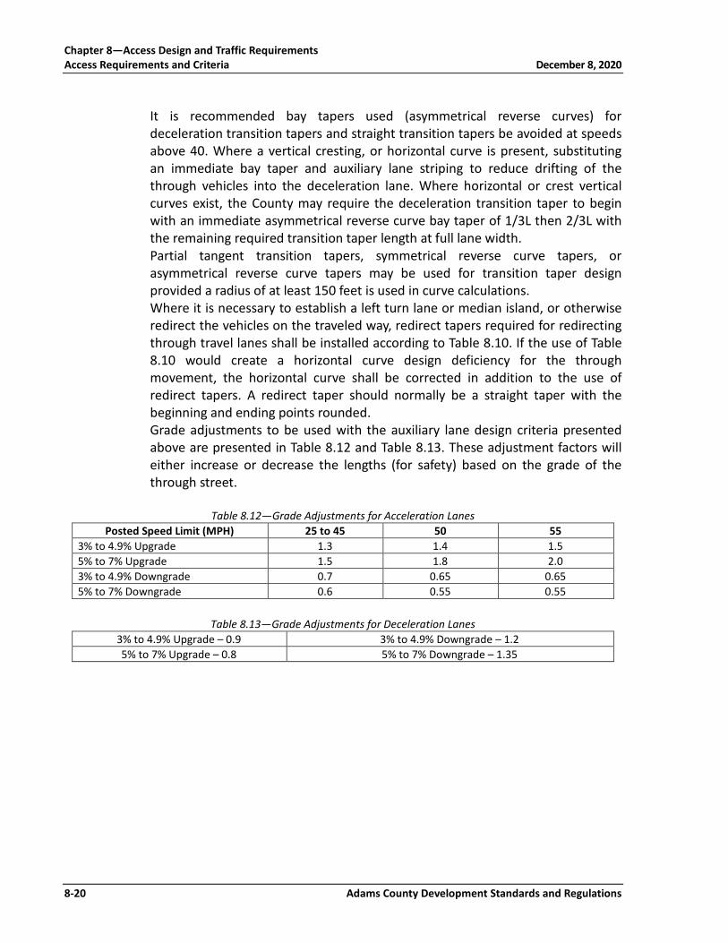
8-01-08-04 DECELERATION AND ACCELERATION DESIGN CRITERIA To determine the required acceleration and deceleration lane and transition taper length, see design criteria presented in Table 8.11. The length of the required transition taper is determined by multiplying the width of the speed change lane by the transition taper ratio value associated with the posted speed in Table 8.11. The beginning and ending point of all tapers shall be rounded.
Table 8.11—Accelaration/Deceleration Lane Design Criteria Posted Speed Limit (MPH) 25 30 35 40 45 50 55
Deceleration Length (Feet) 180 250 310 370 435 500 600 Acceleration Length (Feet) N/A 190 270 380 550 760 960 Transition Taper (Ratio) 7.5:1 8:1 10:1 12:1 13.5:1 15:1 18.5:1 Straight Taper (Ratio) 15:1 15:1 20:1 35:1 45:1 50:1 55:1
Chapter 8—Access Design and Traffic Requirements Access Requirements and Criteria December 8, 2020
8-20 Adams County Development Standards and Regulations
It is recommended bay tapers used (asymmetrical reverse curves) for deceleration transition tapers and straight transition tapers be avoided at speeds above 40. Where a vertical cresting, or horizontal curve is present, substituting an immediate bay taper and auxiliary lane striping to reduce drifting of the through vehicles into the deceleration lane. Where horizontal or crest vertical curves exist, the County may require the deceleration transition taper to begin with an immediate asymmetrical reverse curve bay taper of 1/3L then 2/3L with the remaining required transition taper length at full lane width. Partial tangent transition tapers, symmetrical reverse curve tapers, or asymmetrical reverse curve tapers may be used for transition taper design provided a radius of at least 150 feet is used in curve calculations. Where it is necessary to establish a left turn lane or median island, or otherwise redirect the vehicles on the traveled way, redirect tapers required for redirecting through travel lanes shall be installed according to Table 8.10. If the use of Table 8.10 would create a horizontal curve design deficiency for the through movement, the horizontal curve shall be corrected in addition to the use of redirect tapers. A redirect taper should normally be a straight taper with the beginning and ending points rounded. Grade adjustments to be used with the auxiliary lane design criteria presented above are presented in Table 8.12 and Table 8.13. These adjustment factors will either increase or decrease the lengths (for safety) based on the grade of the through street.
Table 8.12—Grade Adjustments for Acceleration Lanes Posted Speed Limit (MPH) 25 to 45 50 55
3% to 4.9% Upgrade 1.3 1.4 1.5 5% to 7% Upgrade 1.5 1.8 2.0 3% to 4.9% Downgrade 0.7 0.65 0.65 5% to 7% Downgrade 0.6 0.55 0.55
Table 8.13—Grade Adjustments for Deceleration Lanes
3% to 4.9% Upgrade – 0.9 3% to 4.9% Downgrade – 1.2 5% to 7% Upgrade – 0.8 5% to 7% Downgrade – 1.35
Chapter 8—Access Design and Traffic Requirements December 8, 2020 Access Requirements and Criteria
Adams County Development Standards and Regulations 8-21
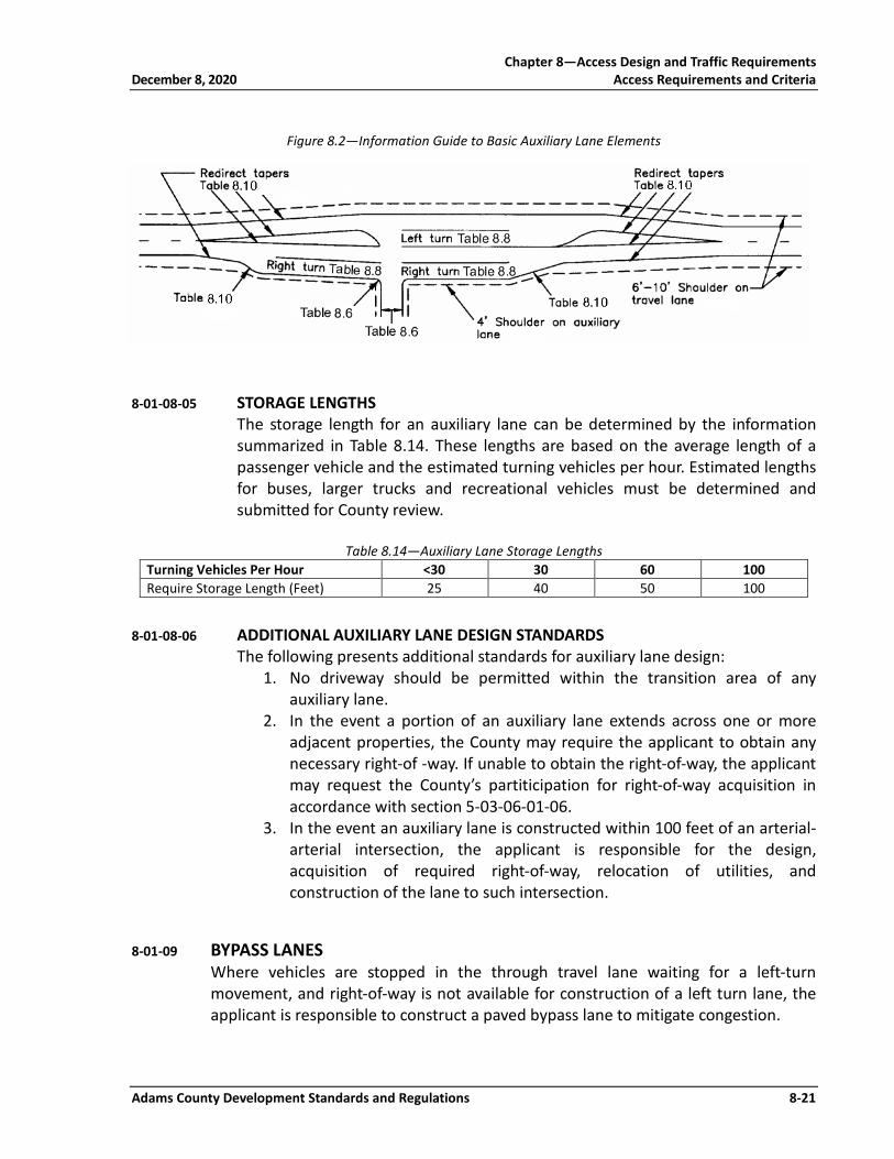
Figure 8.2—Information Guide to Basic Auxiliary Lane Elements
8-01-08-05 STORAGE LENGTHS The storage length for an auxiliary lane can be determined by the information summarized in Table 8.14. These lengths are based on the average length of a passenger vehicle and the estimated turning vehicles per hour. Estimated lengths for buses, larger trucks and recreational vehicles must be determined and submitted for County review.
Table 8.14—Auxiliary Lane Storage Lengths Turning Vehicles Per Hour <30 30 60 100 Require Storage Length (Feet) 25 40 50 100
8-01-08-06 ADDITIONAL AUXILIARY LANE DESIGN STANDARDS The following presents additional standards for auxiliary lane design:
1. No driveway should be permitted within the transition area of any auxiliary lane.
2. In the event a portion of an auxiliary lane extends across one or more adjacent properties, the County may require the applicant to obtain any necessary right-of -way. If unable to obtain the right-of-way, the applicant may request the County’s partiticipation for right-of-way acquisition in accordance with section 5-03-06-01-06.
3. In the event an auxiliary lane is constructed within 100 feet of an arterial-arterial intersection, the applicant is responsible for the design, acquisition of required right-of-way, relocation of utilities, and construction of the lane to such intersection.
8-01-09 BYPASS LANES Where vehicles are stopped in the through travel lane waiting for a left-turn movement, and right-of-way is not available for construction of a left turn lane, the applicant is responsible to construct a paved bypass lane to mitigate congestion.
Chapter 8—Access Design and Traffic Requirements Access Requirements and Criteria December 8, 2020
8-22 Adams County Development Standards and Regulations
8-01-10 UNPERMITTED ACCESS Any access, driveway, or curb-cut which is constructed within the Public ROW without a construction or right-of way permit being issued by the County shall be subject to a “Stop Work” order and shall be removed immediately. Failure to remove the unpermitted access may result in the removal of said access by the County (the cost for removal shall be charged to the property owner from which the access originates). Failure to obey the “Stop Work” order may result in the prosecution of violators.

Chapter 8—Access Design and Traffic Requirements December 8, 2020 Access Requirements and Criteria
Adams County Development Standards and Regulations 8-23
8-02 GUIDELINES FOR TRAFFIC IMPACT STUDIES
8-02-01 GENERAL This chapter contains guidelines for conducting and preparing a Traffic Impact Study (TIS) for submittal to the County. The purpose of a traffic impact study is to assess the short-term and long-term effects of a proposed development project on the transportation system (both local and regional). These guidelines are required to ensure consistent and proper traffic planning and engineering practices when land use actions are being considered within the County. These guidelines provide for a standard process, set of assumptions, set of analytic techniques, and presentation format to be used in the preparation of such traffic impact studies. Project proposals must also maintain the transportation principles and objectives outlined in the County Transportation Plan.
8-02-02 REQUIREMENTS FOR TRAFFIC IMPACT STUDIES Table 8.15 presents the level of TIS required for several possible activities based on the expected trip generation. As presented in the table, some level of TIS is required for all rezoning, plats, conditional use, building permits, driveway permits or change in use. Specific requirements for each of the three levels of TIS efforts are presented in the appropriate Application Package. The amount of detail required is based on the size of the project and estimated impacts to surrounding circulation systems. The same information is required for all three levels of TIS; it is the intensity (area to include) of the study that varies from one level to the next. For each of the three levels of TIS, the studies are to extend approximately 500 feet (Level 1), ¼-mile (Level 2), and 1-mile (Level 3) outside the project limits. Variations to these study limits must receive prior written approval from the Director of Planning. A request for a waiver from the TIS requirement may only be granted following a preliminary scoping meeting as outlined in Section 8-02-03.

Chapter 8—Access Design and Traffic Requirements Access Requirements and Criteria December 8, 2020
8-24 Adams County Development Standards and Regulations
Table 8.15—Traffic Impact Study Requirement Type of Application Expected Trip Generationb Level of Traffic Impact Study (TIS)
Rezoninga 20-50 vpd Level 1 TIS 50-500 vpd Level 2 TIS >500 vpd Level 3 TIS
Residential Plats 20-50 vpd Level 1 TIS 50-250 vpd Level 2 TIS >250 vpd Level 3 TIS
All Other Plats 20-50 vpd Level 1 TIS 50-500 vpd Level 2 TIS >500 vpd Level 3 TIS
Conditional and Temporary Usea
>250 vpd >40 ingress truck trips Level 3 TIS
Multi-year Buildout Developments >100 vpd each phase • Develop a Master TIS for the original land use
• Updated during each filing for specific use
Building Permit, , or Change-in-use Applicationa
20-50 vpd Level 1 TIS 50-500 vpd Level 2 TIS with Driveway Volume and Capacity Analysis
>500 vpd • Driveway Volume and Capacity Analysis • Level 3 TIS
a A limited or Full TIS may be required if one or more of the following conditions are found: • Traffic generated from a non-residential development will significantly impact adjacent residential
neighborhoods. • Traffic operational impacts are anticipated including problems with access, left or right turns, signal
timing, median openings, or sight distance. In such cases, the TIS will only be required to answer questions related to the specific issues.
• Existing traffic operational problems on adjacent streets are expected to be substantially disrupted by traffic generated by the new development.
• Significant citizen opposition is expected for traffic impact and safety reasons. • Cases where the internal street or access system is not anticipated to accommodate the expected traffic
generations. • Safety of High Accident Issues • Significant operational impacts on other modes of transportation. • Description of 3 levels can be found in Section 8-02-02. b Based on ITE Trip Generation Manual. If other data is submitted, applicant will need supporting
documentation.
8-02-03 PRELIMINARY SCOPING MEETING If the criteria determine a Level 2 or Level 3 TIS is required, a preliminary scoping meeting may be held with the County. The purpose of the meeting is to discuss site-specific information, the project scope and requirements of the TIS. It is the responsibility of the applicant to initiate this meeting as they see fit. The following topics should be covered during the meeting:
1. Study Area 2. Available traffic and accident data 3. Plans for roadway improvements in the study area 4. Traffic count availability and/or necessary

Chapter 8—Access Design and Traffic Requirements December 8, 2020 Access Requirements and Criteria
Adams County Development Standards and Regulations 8-25
5. Preliminary traffic distribution and assignment 6. Possible impacted intersections 7. Proposed access and relationship to adjacent properties 8. Preliminary estimates and projected traffic volumes at buildout 9. Phasing plan 10. Need for special analysis 11. Project’s relationship to adopted local transportation study/plan and/or
regional transportation study/plan. 12. Information from cities in the immediate area and/or the Colorado
Department of Transportation. The County will complete a summary of decisions made at the meeting, which will be a consolidated response from the Community and Economic Development Department and the Public Works Department. A copy will be given to the applicant within one week. The response shall include all of the minimum requirements for the traffic study and the County agrees not to expand the scope of the traffic study greater than requested in the initial letter. However, the County reserves the right to make substantive comments during the specified 21-day review and referral period, which may warrant submittal of additional data for the study. The County may determine, at its sole discretion, that a Traffic Impact Study is not required for the proposed development. The decision to waive this requirement shall be jointly agreed upon by the Community and Economic Development Department and the Public Works Department and may be based on some, but not necessarily all of the following issues:
1. Capital Improvement Projects (CIP) in the vicinity of the project; 2. Right-of-way acquisition requirements adjacent to the subject site; 3. Roads currently constructed in the vicinity of the project; 4. Intersections within one mile of the subject site; and 5. Improvements subject to reimbursement to the County or other property
owners under a Subdivision Improvement Agreement (SIA).
8-02-04 RESPONSIBILITIES FOR TRAFFIC IMPACT STUDIES The responsibility for assessing the traffic impacts associated with a proposed land use action resides with the landowner or land development case applicant, with the County serving in a review capacity. The assessment of these impacts shall be within a traffic impact study as specified herein. Level 2 and 3 impact studies shall be prepared under the supervision and sealed by a Registered Professional Engineer in the State of Colorado.

Chapter 8—Access Design and Traffic Requirements Access Requirements and Criteria December 8, 2020
8-26 Adams County Development Standards and Regulations
8-02-05 PLANNING HORIZONS AND ROADWAY NETWORK ASSUMPTIONS Each traffic impact study shall present an analysis of the traffic conditions without and with the proposed project at two planning year horizons: short term and long term. The intent of the first planning horizon is to investigate the immediate impact of the proposed project on the short-term roadway network. The short-term horizon year is defined as five years after occupancy of the project. If the project is proposed to occur over multiple phases, each phase shall be evaluated five years after phase occupancy. The second planning horizon shall be based on the most current Adams County Transportation Plan 20 to 25-year planning horizon. The intent of the second planning horizon is to evaluate implications of the proposed project on the long-range traffic condition. The baseline surface transportation network (without the proposed project improvements) assumed for the first planning horizon should reflect existing facilities plus any firmly committed improvements by the County and other developments within the study area. All DRCOG, Adams County Transportation Plan, or other state and/or locally funded “planned” surface transportation facilities within the study area may be included for the baseline assumptions for the long-term planning horizon network analysis. Each planning horizon analysis shall identify the required facilities needed to bring the Level of Service (LOS) of the affected facilities up to the County established standards. If the established standards are currently exceeded, the study needs to identify:
1. What improvements are necessary to reach established standards and what portion of those improvements are caused by the project, and
2. What improvements are needed to mitigate project impacts. The ultimate network will identify the on-site roadways, site-adjacent improvements, and the potential off-site improvements required and proposed by the project.
8-02-06 TIS REPORT REQUIREMENTS The information contained in this section outlines the highest level of detail required for all traffic impact studies submitted to the County for review and approval (see Application Package for specific requirements). Maps required in individual sections shall be placed in the TIS as well. The TIS report shall be typed and bound. It shall contain a table of contents and lists of figures and tables.
8-02-06-01 SUMMARY The Summary section shall be prepared utilizing the “Summary of Traffic Impact” sheets included with this section (see end of chapter). Additional maps and tables may be required to provide clarity to individual sections of the report. The Summary shall be provided as a condensed, stand alone document. It is

Chapter 8—Access Design and Traffic Requirements December 8, 2020 Access Requirements and Criteria
Adams County Development Standards and Regulations 8-27
incumbent on the applicant that all of the required data and information clearly identified in the appropriate sections of the report be produced. The information contained in the TIS and associated Appendices are accurate and complete prior to submitting it to the County.
8-02-06-01-01 PROJECT OVERVIEW This section will provide answers to the question of why a traffic analysis is required for the proposed project, and describe the approval request. The overview section shall also contain a discussion of the horizon years and findings/recommendations.
8-02-06-01-02 SITE LOCATION AND STUDY AREA BOUNDARIES A vicinity map will be provided illustrating the site, study area, and the surrounding transportation network. A brief description of the location of the site within the County and the region shall be included. The limits of the study area should be based on the size and extent of the proposed development, and an understanding of existing and future land use and traffic conditions at and around the site. The reasons for selecting the study area will be described in sufficient detail so that the reviewer can understand the reasoning. At a minimum, the study area shall contain:
1. Adjacent streets, 2. Nearest arterial/arterial intersection(s), 3. Site driveways, 4. Internal roads, 5. All major signalized or potentially future signalized intersections,
either current or future years, where: a. The project contributes a 5 percent impact (during either the a.m.
or p.m. peak hour) to any approach leg of the intersection where the intersection is operating at an acceptable level of service, or
b. The project contributes a 2 percent impact (during either the a.m. or p.m. peak hour) to any approach leg of the intersection where the intersection is operating at an unacceptable level of service.
8-02-06-01-03 DESCRIPTION OF SITE A brief description of the site shall be provided and include, as a minimum, a description of its size, general terrain features, existing zoning and use, and proposed zoning and use. A map shall be included showing buildout conditions of the subject property including the following:
1. The site street system, 2. Roadway classifications, 3. Number of travel lanes,

Chapter 8—Access Design and Traffic Requirements Access Requirements and Criteria December 8, 2020
8-28 Adams County Development Standards and Regulations
4. Street width, 5. Existing and proposed ROW dimensions, 6. Existing and proposed driveways and accesses (with turning
movements), and 7. Map of curb, gutter and sidewalk (available existing and proposed).
Similar information for adjacent property shall be provided as well, if available, on the same map. The data presented in this TIS report shall be identical in every respect to the site plan submitted for development approval. For situations where a site plan does not exist, a prototypical site roadway and access system should be assumed for purposes of the study. Subsequent update will be necessary when a site plan becomes available.
8-02-06-01-04 EXISTING AND PROPOSED USES IN VICINITY OF SITE The identification of existing and anticipated land uses in the general vicinity of the site must be performed in order to understand other influences to area traffic patterns. Specific attention should be paid to property adjacent to the site and any undeveloped land in the study area. A map shall be prepared for the project vicinity that graphically depicts the location of approved or proposed developments. Projects within the study area but in other jurisdictions shall also be identified on the map and documented. Proposed projects, which may impact adjacent jurisdictions, will be referred to those jurisdictions for consideration.
8-02-06-01-05 EXISTING AND COMMITTED TRANSPORTATION NETWORK A map showing the “planned” transportation network for the short term and long term planning horizons must be prepared and submitted for review. Committed/funded improvements by the County and previously approved developments shall be identified for the short and long term horizon years. Source of funds shall also be identified. The long term improvements shall be those documented in the Adams County Transportation Plan and any other long term improvements adopted through special studies sponsored by the County. The improvements (at either planning year) of other local jurisdictions, agencies, and developments within the study area shall be identified. The nature of their improvement projects, their extent, implementation schedule, funding source, and responsible party shall be identified.
8-02-06-02 EXISTING TRAFFIC CONDITIONS A description and plan of the existing traffic conditions within the study area shall be prepared, which presents a minimum of three hours each of a.m. and p.m. peak and daily traffic volumes. These volumes shall be no more than two years old. If the project is in a high growth area they shall be less than one year.

Chapter 8—Access Design and Traffic Requirements December 8, 2020 Access Requirements and Criteria
Adams County Development Standards and Regulations 8-29
The source of existing traffic volume information should be explicitly stated (CDOT counts, new counts developed for the project, County counts, etc.) Summaries of current traffic counts shall be included in the appendix. A map of the existing roadway network shall be prepared that presents lane geometrics, traffic control, existing access, speed limits, and any other notable features. Existing a.m. and p.m. peak hour intersection levels of service shall be determined for signalized and unsignalized intersections within the study area based on procedures described in the latest edition of the Highway Capacity Manual. The existing arterials shall also be analyzed based on a daily volume/capacity ratio analysis where the threshold capacities are defined by arterial designation per Table 8.16. Volume/capacity ratios which exceed 1.00 shall be identified. It should be noted these are general thresholds for planning purposes only, and a supplementary peak hour analysis should be considered. These daily volume/capacity ratios shall be recorded on the existing volume map.
Table 8.16—Threshold Capacity Facility Type Lanes A.D.T Threshold Capacity
Local-Residential 2 1,500 Local-Commercial/Industrial 2 2,500 Minor Collector 2 12,000 Major Collector 4 24,000 Minor Arterial 4 32,000 Major Arterial 4 min. 48,000
8-02-06-03 FUTURE TRAFFIC CONDITIONS WITHOUT PROPOSED DEVELOPMENT Long term a.m. and p.m. peak hour planning horizon traffic forecasts shall be based on the most recent Transportation Plan traffic forecasts. Long term peak hour estimates shall be provided in sufficient detail to understand the recommended forecasts. It should be noted the forecasts are based on future year population and employment projections, which reflect a regional perspective on growth and development. The applicant and consultant shall investigate those land use assumptions as they apply to their project study area and make forecast adjustments as necessary. A short and long term planning horizon traffic forecast shall be prepared for the project. The short term planning horizon is five years after project occupancy. The short term planning horizon traffic forecast shall be the sum of existing traffic volumes plus cumulative development traffic plus ambient growth. The short term planning horizon traffic forecasts should also include cumulative development traffic from other jurisdictions within the study area. The short term planning horizon year ambient growth rate traffic forecasts shall be based on:
1. Proportion between existing traffic volumes and buildout regional model forecasts,
2. Extrapolation from historical traffic counts to current counts, and/or
Chapter 8—Access Design and Traffic Requirements Access Requirements and Criteria December 8, 2020
8-30 Adams County Development Standards and Regulations
3. Planning analysis which considers trends in the areas circulation system through either a proportion or extrapolation estimate.
Whatever method is used to develop the annual growth rate for determining ambient traffic, it is important the method be documented with sufficient detail to replicate the findings. The map of the committed and funded improvements (for each planning horizon) as required shall be used as a base for determining short term and long term planning horizon levels of service. The identification of improvements that would mitigate unacceptable levels of service under the traffic conditions (without the proposed project) must be developed. In addition to what improvements are needed, it is also important to identify when these improvements are needed. The time when improvements are necessary could be defined by when a traffic threshold is reached, or by year.
8-02-06-04 PROPOSED PROJECT TRAFFIC Project traffic will be developed based on the traditional trip generation, distribution, and assignment process described as follows.
8-02-06-04-01 TRIP GENERATION A completed “Traffic Generation Summary Sheet” (Table 8.17), listing each type of land use within the site at build-out, the size involved, the average trip generation rates used (total daily traffic and a.m./p.m. peaks), and the resultant total trips generated shall be submitted as part of the project TIS. Build-out land uses and generation shall be for both the short term and long term planning horizons. If, however, the land use action is of a type that build-out in the short-term is not feasible due to the size of development, interim phases, such as 2-year increments, shall be developed.
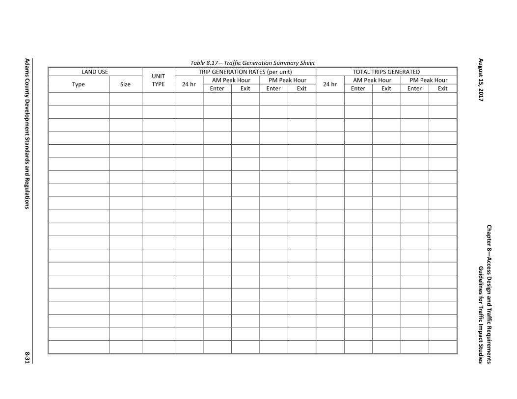
Table 8.17—Traffic Generation Summary Sheet LAND USE
UNIT TYPE
TRIP GENERATION RATES (per unit) TOTAL TRIPS GENERATED
Type Size 24 hr AM Peak Hour PM Peak Hour
24 hr AM Peak Hour PM Peak Hour
Enter Exit Enter Exit Enter Exit Enter Exit
Adams County Developm
ent Standards and Regulations 8-31
Chapter 8—
Access Design and Traffic Requirements
August 15, 2017 G
uidelines for Traffic Impact Studies

Chapter 8—Access Design and Traffic Requirements Guidelines for Traffic Impact Studies December 8, 2020
8-32 Adams County Development Standards and Regulations
Trip generation should be calculated from the latest data contained within the Institute of Transportation Engineers' Trip Generation report or other industry publications such as the ITE Journal. Data limitations, data age, choice of peak hour or adjacent street traffic, choice of independent variable and choice of average rate versus statistical significant modification shall be presented and discussed. In the event data is not available for a proposed land use, a local trip generation study following procedures prescribed in the ITE Trip Generation manual must be completed to provide sufficient justification for the proposed generation rate. This rate must be acceptable to the County.
8-02-06-04-02 ADJUSTMENTS TO TRIP GENERATION RATES After first generating trips at full ITE rates, trip-making reduction factors may be used. These factors fall into two categories: those which reassign some portion of generated trips to the background stream of traffic, and those which “remove” or “move” generated trips. In all cases, the underlying assumptions of the ITE Trip Generation rates must be recognized and considered before any reductions are claimed. The first category is when trips to the proposed development currently exist as part of the background traffic stream, referred to as a passby trip. Passby percentages identified in the ITE Trip Generation manual or other industry publications may be used. This traffic must continue to be assigned to site driveways and access points, but is not additive to the background stream of traffic. A technical appendix that illustrates the rediversion of passby trips is recommended. The second category for adjustments is for internal site trips, transit use, and TDM (transportation demand management) actions. In general, reductions are not recommended. However, if reductions are claimed, analytic support to show how the figures were derived must be provided. Optimistic assumptions regarding transit use and TDM actions will not be acceptable unless accompanied by specific implementation proposals that will become a condition of approval. Such implementation proposals must have a reasonable expectation of realization within a 5-year period after project initiation.
8-02-06-04-03 TRIP GENERATION BUDGET Major concerns arise when the TIS identifies a trip generation rate less than what ultimately is experienced once the development is built and occupied. The impacts on the community due to underestimating these trip generations may become great. It is recognized the trip generation process is ultimately dependent on a number of market and social factors; however, it is imperative the TIS be sufficiently conservative to account for full impact of the proposed development.

Chapter 8—Access Design and Traffic Requirements December 8, 2020 Guidelines for Traffic Impact Studies
Adams County Development Standards and Regulations 8-33
To assure the public and the County the traffic impact analysis adequately addresses the full impact of the development, the trip generation of the proposed development will establish the maximum amount of trips permitted from the development. If a future traffic impact is experienced which was not addressed in the traffic study, and determined a part to a project’s trip generation exceeding the trip generation assumed in the traffic study, the County may require the development to either 1) make additional improvements to reduce the project traffic volumes to the amount estimated in the traffic study, or 2) provide for additional mitigations to the project traffic. This requirement will become a condition of all development approvals requiring a traffic study. Two specific situations will be closely reviewed. The first is when the traffic study assumes rates where the collection of mixed uses, such as at a shopping center, result in lower peak hour trips than when applying individual rates to each land use. The second is when reductions in the trip generation rates are assumed based on reductions due to travel demand management. If the trip budget is reached prior to full occupancy, the County reserves the right to request supplemental traffic analyses and/or additional mitigations prior to granting full occupancy permits. If the project is fully occupied and it is determined the development traffic exceeds that which was included in the traffic study, then the property owner may be requested to conduct additional traffic analysis and provide additional mitigation.
8-02-06-04-04 TRIP DISTRIBUTION Trip distribution may be based on the County and/or DRCOG traffic forecasts, market analysis, existing traffic flows, applied census data, and professional judgment. Regardless of the estimates, the procedures and logic for estimating the trip distributions must be well documented. The trip distribution patterns must be presented for each phase if changes in roadway network, access or land uses are proposed. The distribution percentages shall be noted on the Summary of Traffic Impacts sheet.
8-02-06-04-05 PROJECT TRIP ASSIGNMENT This section shall present the forecast project traffic assignment based on the project’s trip generation estimates and project trip distribution. The traffic forecasts shall be graphically presented and include: a.m. peak hour, p.m. peak hour, and total daily site-generated traffic. If trip generation is different for the short term and long term planning horizons, both should be shown on separate graphics. “Pass-by” traffic should be included at driveways and access points.

Chapter 8—Access Design and Traffic Requirements Guidelines for Traffic Impact Studies December 8, 2020
8-34 Adams County Development Standards and Regulations
8-02-06-05 FUTURE TRAFFIC FORECASTS WITH THE PROPOSED DEVELOPMENT A graphical summary of the short term and long term horizon year traffic plus the proposed project traffic for the four hours of a.m. peak, four hours of p.m. peak, and daily conditions shall be completed. These volumes shall include turn movements at the key intersections. The base map for this exhibit shall reflect the respective transportation network by planning horizons.
8-02-06-06 PROJECT IMPACTS The key elements of the project impact analysis include: 1. Generalized daily traffic volume level of service 2. A peak hour intersection level of service 3. The appropriateness of access locations and the need for future traffic
signals 4. Turn lane storage requirements 5. Sight distance 6. Appropriateness of acceleration or deceleration lanes The requirements for these six evaluations are as follows.
8-02-06-06-01 GENERALIZED DAILY TRAFFIC VOLUME LEVEL OF SERVICE Using the daily traffic volumes forecast and general daily level of service thresholds, a general evaluation should be made of the arterial street system for the short term and long term horizon years. Incremental differences attributable to the land use action should be identified. A map showing generalized levels of service should be presented for each design year.
8-02-06-06-02 PEAK HOUR INTERSECTION LEVEL OF SERVICE An a.m. and p.m. peak hour intersection level of service analysis shall be conducted for each intersection, based on procedures specified in the most recent release of the Highway Capacity Manual. All level of service analysis worksheets shall be included in the Appendix. The principal objective of the intersection level of service traffic impact analysis is to identify whether the traffic from the proposed project when added to the existing plus short and long term planning horizon traffic will result in a significant impact and an unacceptable level of service. For definitional purposes, the threshold for acceptable level of service is C during off-peak hours and not less than level of service D for peak hours. Significance is defined as: 1) when the added project traffic causes the level of service to exceed the established threshold, or 2) when the short term or long term horizon year traffic without the project exceeds the established threshold, and the project traffic causes a 2% increase in the volume/capacity ratio or delay.

Chapter 8—Access Design and Traffic Requirements December 8, 2020 Guidelines for Traffic Impact Studies
Adams County Development Standards and Regulations 8-35
8-02-06-06-03 TRAFFIC SIGNALS AND ACCESS LOCATIONS The appropriateness of the project’s access locations and type must be established. For full-access locations, a signal warrant analysis based on the Manual on Uniform Traffic Control Devices must be conducted for each design year. Traffic signals specifically warranted by the land use action shall be identified. The acceptability of the signal locations must be demonstrated through a signal progression (time-space) analysis. The analysis shall consider any existing access or intersection or a possible future signal location along the arterial for a distance of at least one mile in each direction of the proposed signal. A cycle length of between 80 and 120 seconds should be selected and agreed to by County staff. A travel speed of 45 mph on majors and 35 mph on minors, unless the existing posted speed limit is less, must be used. A major arterial bandwidth of 50% and a minor arterial bandwidth of 40% are considered desirable, and must be used where existing conditions allow. Where intersections or other accesses have no signals presently, but are expected to have signals, a 60% mainline, 40% cross street cycle split should be assumed. Where more detailed information is available from turning movement projections, other split assumptions may be made. Any access that would reduce the desirable bandwidth if a traffic signal were installed shall be identified. In general terms, access should remain unsignalized and have turning movements limited by driveway design or median islands, unless the impacts to traffic operation and safety are made even worse by doing so. The implications of the land use action upon the adequacy of the signal locations for each design year shall be provided. Distances between signalized intersections (centerline) shall be indicated. Signal progression worksheets (time-space diagrams) shall be included in the Appendix.
8-02-06-06-04 TURN LANE STORAGE REQUIREMENTS Turn lane storage needs shall be identified for the “necessary” situation, based on projected turning volumes and AASHTO analytic techniques. Appropriate documentation of the calculations must be provided.
8-02-06-06-05 SIGHT DISTANCE The identification of project sight distance at the project entrances and all internal streets shall be conducted. Line of sight triangles for determining sight distances and landscape restrictions shall be prepared and submitted in accordance with information presented in Chapter 7.
8-02-06-06-06 ACCELERATION OR DECELERATION LANES All proposed project entrances on arterials shall be evaluated as to whether they require acceleration lanes or deceleration lanes per the most recent
Chapter 8—Access Design and Traffic Requirements Guidelines for Traffic Impact Studies December 8, 2020
8-36 Adams County Development Standards and Regulations
release of the Colorado Department of Transportation State Highway Access Code.
8-02-06-07 SPECIAL ANALYSIS/ISSUES This section provides the County with opportunities to request specific focused traffic analyses relevant to the proposed development. These could include access control, access spacing, accident/safety concerns, cut through traffic and residential quality of life, truck estimates and pavement design, accident statistics, pedestrian safety, safe routes to schools, emergency routes, etc. This section would also contain environmental and regional air quality conformity analysis as necessary.
8-02-06-08 MITIGATION MEASURES/RECOMMENDATIONS This section shall describe the location, nature, and extent of all transportation improvements the applicant recommends to yield reasonable operating conditions in each horizon year with the land use action approved as requested. For this discussion, the following terms apply:
1. Planned - Improvements planned having committed funding, including those identified in short term capital improvement programs by County, district, or other agency.
2. Background Committed - Improvements committed to by previously approved development.
3. Applicant Committed - There are two conditions where improvements need to be identified: a. When existing plus cumulative traffic with planned and background
improvements exceed established levels of service, the applicant shall identify mitigation to offset project impacts.
b. When existing plus cumulative traffic with planned and background improvements do not exceed established levels of service, the applicant shall identify mitigation to achieve established levels of service.
4. Necessary - Improvements required to mitigate background plus applicant traffic to established levels of service, regardless of project contribution.
The reason “necessary” improvements must be explored is often the “background committed” or “planned” improvements plus the improvements the applicant typically understands and commits to are not adequate to provide the established level of service. In addition, the assurance all-practical solutions have been considered when developing the list of “necessary” improvements, so the resulting operating conditions are made to approach the established level of service must be performed.

Chapter 8—Access Design and Traffic Requirements December 8, 2020 Guidelines for Traffic Impact Studies
Adams County Development Standards and Regulations 8-37
For purposes of identifying improvement possibilities (either by the applicant or by the County or state) “necessary” to yield an acceptable level of service, the cost of the improvements shall not be considered a limiting constraint within the context of the traffic impact study. However, the goal of the evaluation is to identify cost-effective solutions that yield a reasonable level of service. Extremely high-cost solutions may not be cost-effective, but it is important to at least identify solutions so decision-makers are cognizant of existing options. Table 8.19, “Recommended Improvements Summary Sheet,” is a summary sheet of recommendations being proposed for the subject project. One sheet may be used for both design years if all the improvements can be conveniently described thereon. If not, one or more sheets should be completed for each design year. All recommended improvements should be identified on the Summary Sheet, including “planned,” “background committed,” “applicant committed,” and “necessary.” Each project should be briefly described as to its location, the type of project, flow line and right-of-way needs (for roadways), signal or turn lane improvements (for intersections), and, at a sketch planning level, cost of the improvement. Also, commitment to the improvement should be identified, either by local governments, districts, or by the applicant himself (this may include both the “applicant committed” and “necessary” projects). Identification of a project as “not currently committed” may be an appropriate description for many needed projects, including some of those that are “planned.” However, the goal of the recommendations should be to identify a firm program of improvements that will support the proposed land use action and background traffic in each design year. It is further required all geometric improvements such as pavement markings, signs, adding through or turn lanes, adding project access and assorted turn lanes, acceleration lanes, and changes in medians, shall be presented in a schematic scaled drawing, preferably on a current aerial map. Sufficient dimensions shall be identified to facilitate review. Right-of-way needs shall also be identified on the plan.
8-02-07 REQUIREMENTS FOR UPDATING EXISTING TRAFFIC IMPACT STUDIES The following are three (3) scenarios that will require the preparation of an update (or amendment) to a previous study, or the preparation of an entirely new study which meets these guidelines.
1. When time or circumstances of the original study fall within the parameters presented in Table 8.18, the applicant shall prepare the appropriate documentation according to the following specific requirements.
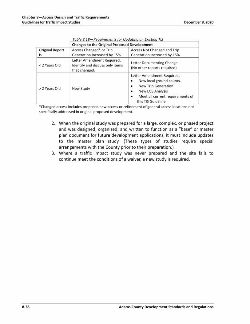
Chapter 8—Access Design and Traffic Requirements Guidelines for Traffic Impact Studies December 8, 2020
8-38 Adams County Development Standards and Regulations
Table 8.18—Requirements for Updating an Existing TIS Changes to the Original Proposed Development Original Report Is
Access Changed* or Trip Generation Increased by 15%
Access Not Changed and Trip Generation Increased by 15%
< 2 Years Old Letter Amendment Required: Identify and discuss only items that changed.
Letter Documenting Change (No other reports required)
> 2 Years Old New Study
Letter Amendment Required: • New local ground counts. • New Trip Generation • New LOS Analysis • Meet all current requirements of
this TIS Guideline *Changed access includes proposed new access or refinement of general access locations not specifically addressed in original proposed development.
2. When the original study was prepared for a large, complex, or phased project
and was designed, organized, and written to function as a ”base” or master plan document for future development applications, it must include updates to the master plan study. (These types of studies require special arrangements with the County prior to their preparation.)
3. Where a traffic impact study was never prepared and the site fails to continue meet the conditions of a waiver, a new study is required.

Table 8.19—Recommended Improvements Summary Sheet
Roadway Improvements
Street Location Improvement Description1 Commitment Identification2
Intersection Improvements
Street Location Improvement Description3 Commitment Identification2
1Describe improvement type, number of lanes, functional classification, flowline and R.O.W. needs, and planning level cost 2Describe project implementation requirements and identify project sponsor and type of funding. (i.e., explain whether the improvement is to be funded
by the developer, improvement district, or other source. 3Describe improvement type and identify planning level cost.
Adam
s County D
evelopment Standards and R
egulations 8-39
C
hapter 8—A
ccess Design and Traffic R
equirements
August 15, 2017
Guidelines for Traffic Im
pact Studies