accessible travel: evolving the practice of providing geo ...€¦ · accessible public transit...
TRANSCRIPT
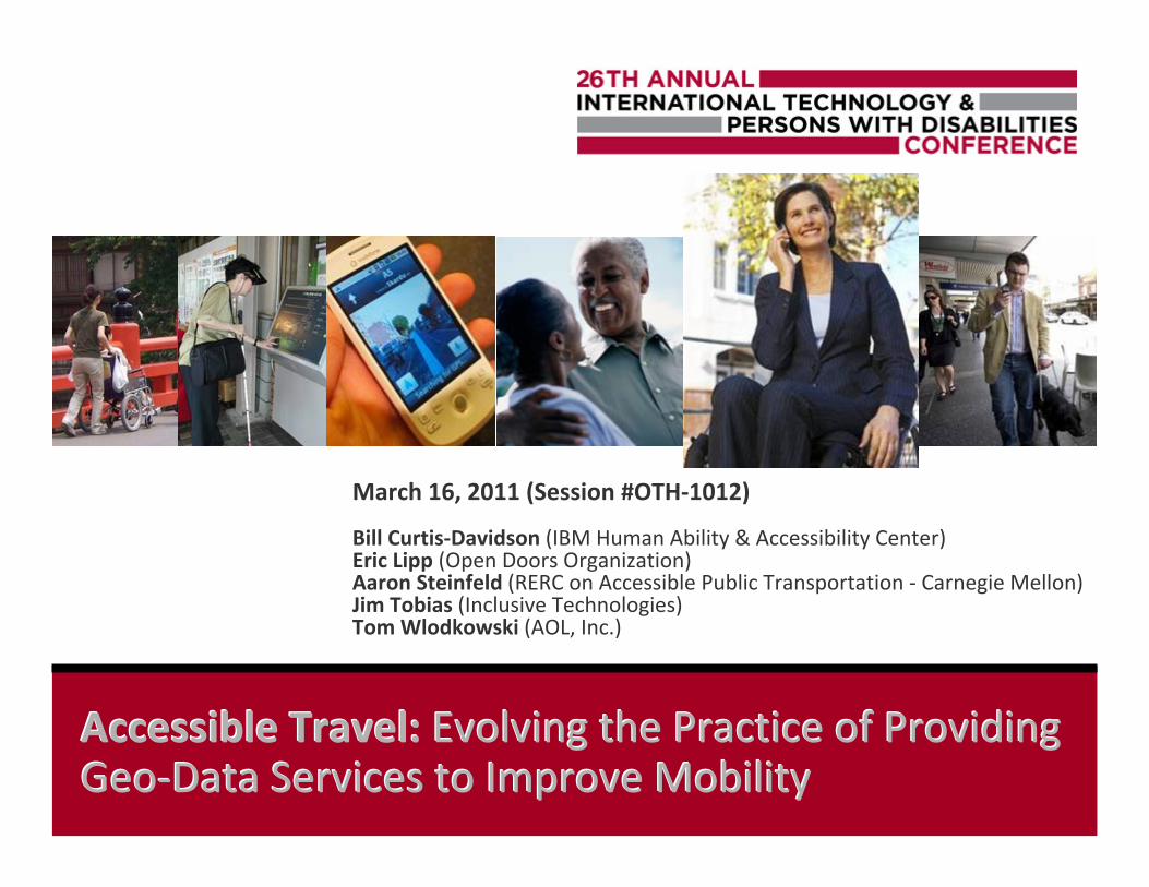
Accessible Travel: Accessible Travel: Evolving the Practice of Providing Evolving the Practice of ProvidingGeo-Data Services to Improve MobilityGeo-Data Services to Improve Mobility
March 16, 2011 (Session #OTH-1012)
Bill Curtis-Davidson (IBM Human Ability & Accessibility Center)Eric Lipp (Open Doors Organization)Aaron Steinfeld (RERC on Accessible Public Transportation - Carnegie Mellon)Jim Tobias (Inclusive Technologies)Tom Wlodkowski (AOL, Inc.)

Panelist IntroductionsPanelist Introductions
Bill Curtis-Davidson Accessible Transportation Solutions Leader IBM Human Ability & Accessibility Center
Eric Lipp President & Founder Open Doors Organization
Aaron Steinfeld Co-Director RERC on Accessible Public Transportation Carnegie Mellon University
Jim Tobias Principal Inclusive Technologies
Tom Wlodkowski Director of Accessibility AOL Inc.
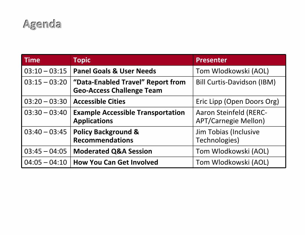
AgendaAgenda
Time Topic Presenter
03:10 – 03:15 Panel Goals & User Needs Tom Wlodkowski (AOL)
03:15 – 03:20 “Data-Enabled Travel” Report from Geo-Access Challenge Team
Bill Curtis-Davidson (IBM)
03:20 – 03:30 Accessible Cities Eric Lipp (Open Doors Org)
03:30 – 03:40 Example Accessible Transportation Applications
Aaron Steinfeld (RERC-APT/Carnegie Mellon)
03:40 – 03:45 Policy Background & Recommendations
Jim Tobias (Inclusive Technologies)
03:45 – 04:05 Moderated Q&A Session Tom Wlodkowski (AOL)
04:05 – 04:10 How You Can Get Involved Tom Wlodkowski (AOL)

Panel GoalsPanel Goals
Through this panel, we hope to help attendees: � Understand the market context for accessible travel
� Understand how open data is being leveraged in accessible travel
� Understand some types of transformative applications being developed using open data for accessible travel
� Understand industry activities that you can engage in to support development of innovative technologies to support accessible travel
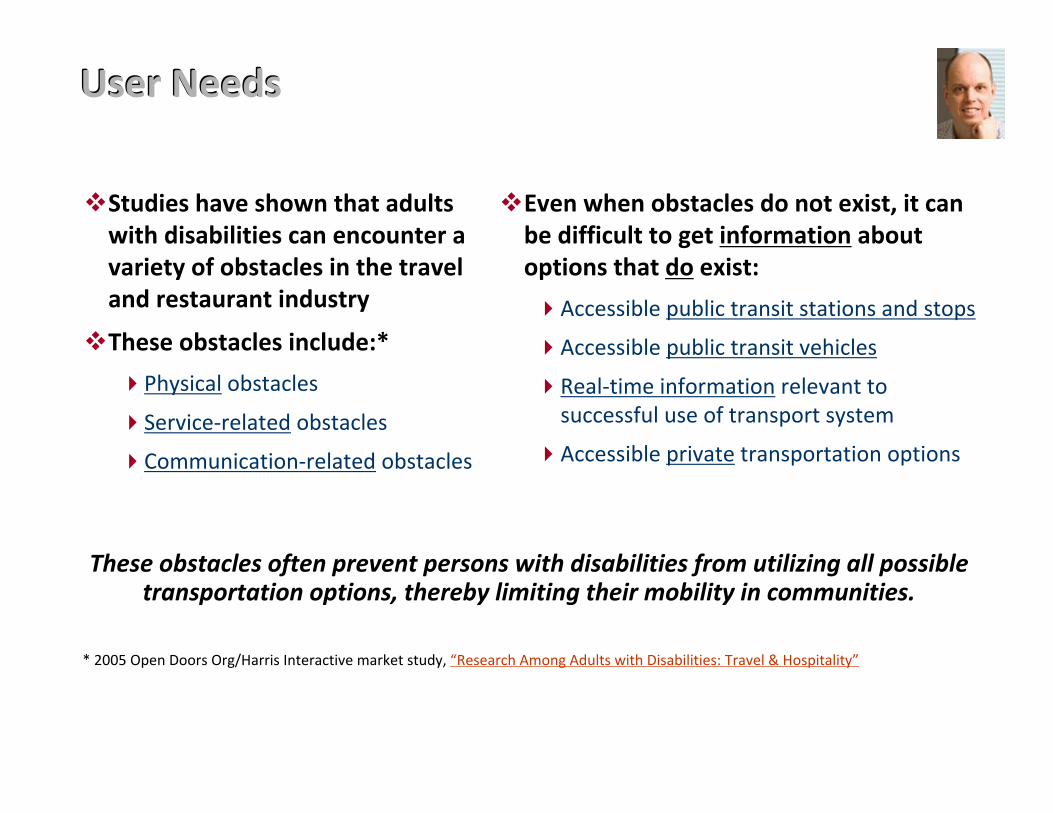
User NeedsUser Needs
�Studies have shown that adults with disabilities can encounter a variety of obstacles in the travel and restaurant industry
�These obstacles include:*
�Physical obstacles
�Service-related obstacles
�Communication-related obstacles
Even when obstacles do not exist, it can be difficult to get information about options that do exist:
�Accessible public transit stations and stops
�Accessible public transit vehicles
�Real-time information relevant to successful use of transport system
�Accessible private transportation options
�
These obstacles often prevent persons with disabilities from utilizing all possible transportation options, thereby limiting their mobility in communities.
* 2005 Open Doors Org/Harris Interactive market study, “Research Among Adults with Disabilities: Travel & Hospitality”
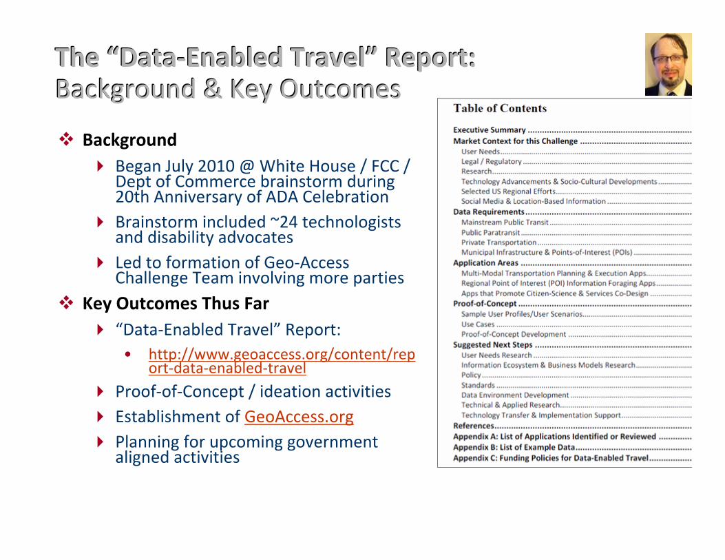
The “Data-Enabled Travel”The “Data-Enabled Travel” RReport: eport:Background & Key OutcomesBackground & Key Outcomes
� Background � Began July 2010 @ White House / FCC /
Dept of Commerce brainstorm during20th Anniversary of ADA Celebration
� Brainstorm included ~24 technologistsand disability advocates
� Led to formation of Geo-Access Challenge Team involving more parties
� Key Outcomes Thus Far � “Data-Enabled Travel” Report:
• http://www.geoaccess.org/content/report-data-enabled-travel
� Proof-of-Concept / ideation activities � Establishment of GeoAccess.org � Planning for upcoming government
aligned activities
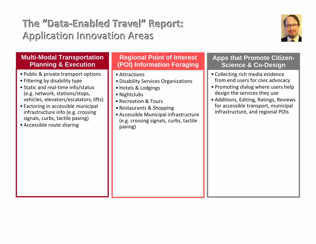
The “Data-Enabled Travel”The “Data-Enabled Travel” RReport: eport:Application Innovation AreasApplication Innovation Areas
Multi-Modal TransportationPlanning & Execution
• Public & private transport options • Filtering by disability type • Static and real-time info/status
(e.g. network, stations/stops, vehicles, elevators/escalators, lifts)
• Factoring in accessible municipal infrastructure info (e.g. crossing signals, curbs, tactile paving)
• Accessible route sharing
Regional Point of Interest(POI) Information Foraging
• Attractions • Disability Services Organizations • Hotels & Lodgings • Nightclubs • Recreation & Tours • Restaurants & Shopping • Accessible Municipal infrastructure
(e.g. crossing signals, curbs, tactile paving)
Apps that Promote Citizen-Science & Co-Design
• Collecting rich media evidence from end users for civic advocacy
• Promoting dialog where users help design the services they use
• Additions, Editing, Ratings, Reviews for accessible transport, municipal infrastructure, and regional POIs
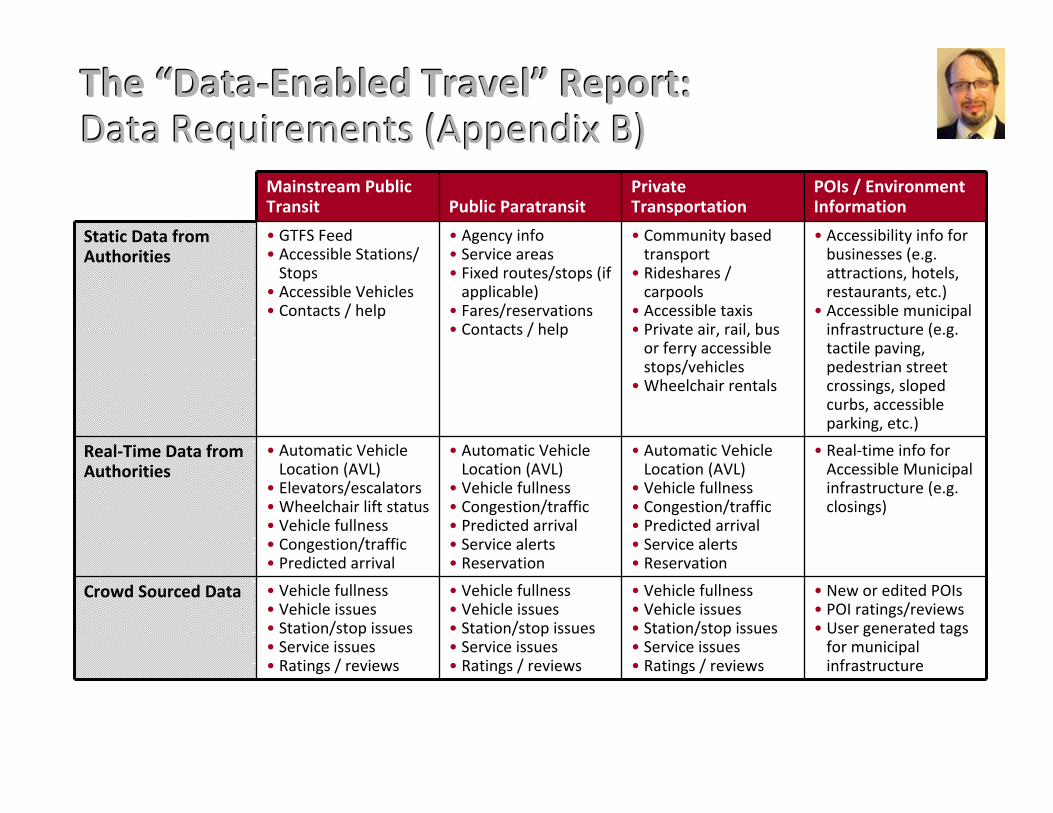
The “Data-Enabled Travel”The “Data-Enabled Travel” RReport: eport:Data Requirements (Appendix B)Data Requirements (Appendix B)
Mainstream Public Transit Public Paratransit
Private Transportation
POIs / Environment Information
Static Data from Authorities
• GTFS Feed • Accessible Stations/
Stops • Accessible Vehicles • Contacts / help
• Agency info • Service areas • Fixed routes/stops (if
applicable) • Fares/reservations • Contacts / help
• Community based transport
• Rideshares / carpools
• Accessible taxis • Private air, rail, bus
or ferry accessible stops/vehicles
• Wheelchair rentals
• Accessibility info for businesses (e.g. attractions, hotels, restaurants, etc.)
• Accessible municipal infrastructure (e.g. tactile paving, pedestrian street crossings, sloped curbs, accessible parking, etc.)
Real-Time Data from Authorities
• Automatic Vehicle Location (AVL)
• Elevators/escalators • Wheelchair lift status • Vehicle fullness • Congestion/traffic • Predicted arrival
• Automatic Vehicle Location (AVL)
• Vehicle fullness • Congestion/traffic • Predicted arrival • Service alerts • Reservation
• Automatic Vehicle Location (AVL)
• Vehicle fullness • Congestion/traffic • Predicted arrival • Service alerts • Reservation
• Real-time info for Accessible Municipal infrastructure (e.g. closings)
Crowd Sourced Data • Vehicle fullness • Vehicle issues • Station/stop issues • Service issues • Ratings / reviews
• Vehicle fullness • Vehicle issues • Station/stop issues • Service issues • Ratings / reviews
• Vehicle fullness • Vehicle issues • Station/stop issues • Service issues • Ratings / reviews
• New or edited POIs • POI ratings/reviews • User generated tags
for municipal infrastructure
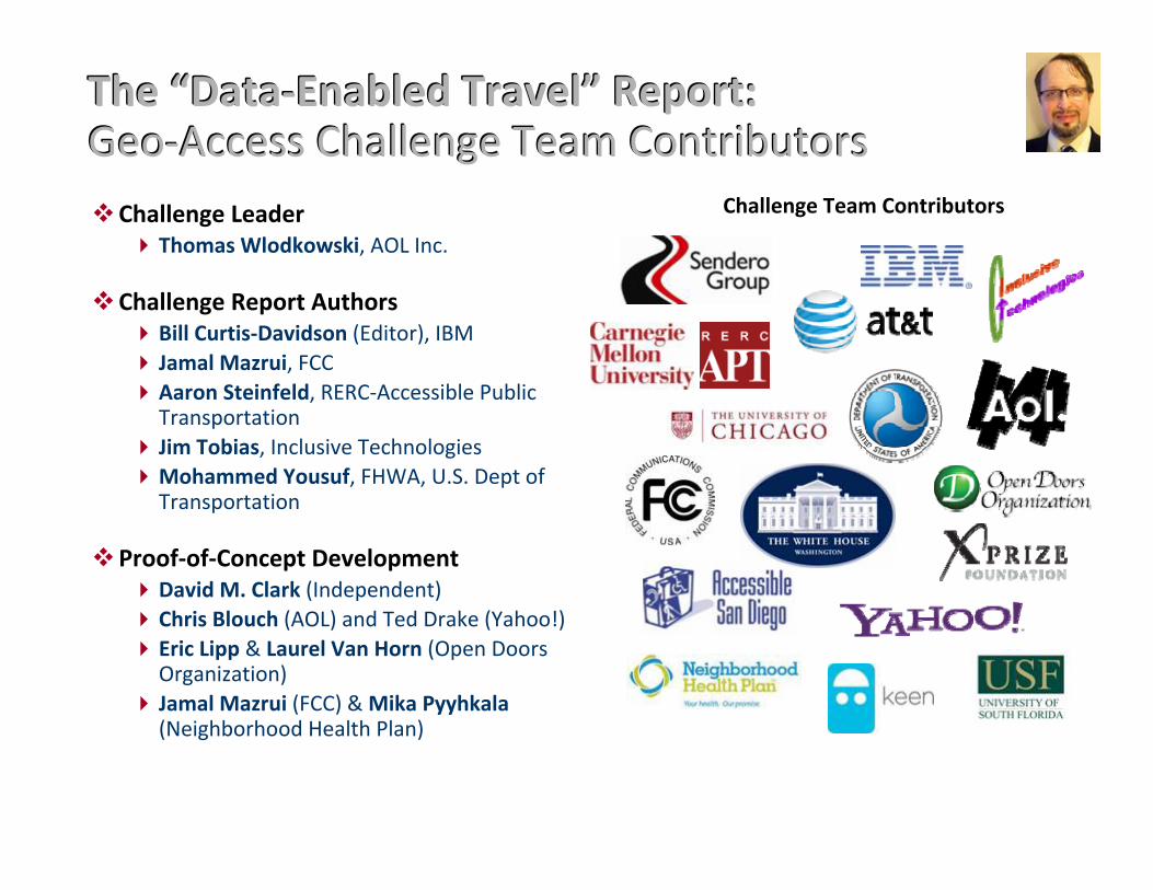
The “Data-Enabled Travel”The “Data-Enabled Travel” RReport: eport:Geo-Access Challenge Team ContributorsGeo-Access Challenge Team Contributors�Challenge Leader � Thomas Wlodkowski, AOL Inc.
�Challenge Report Authors �Bill Curtis-Davidson (Editor), IBM � Jamal Mazrui, FCC �Aaron Steinfeld, RERC-Accessible Public
Transportation� Jim Tobias, Inclusive Technologies �Mohammed Yousuf, FHWA, U.S. Dept of
Transportation
�Proof-of-Concept Development �David M. Clark (Independent) �Chris Blouch (AOL) and Ted Drake (Yahoo!) � Eric Lipp & Laurel Van Horn (Open Doors
Organization)� Jamal Mazrui (FCC) & Mika Pyyhkala
(Neighborhood Health Plan)
Challenge Team Contributors
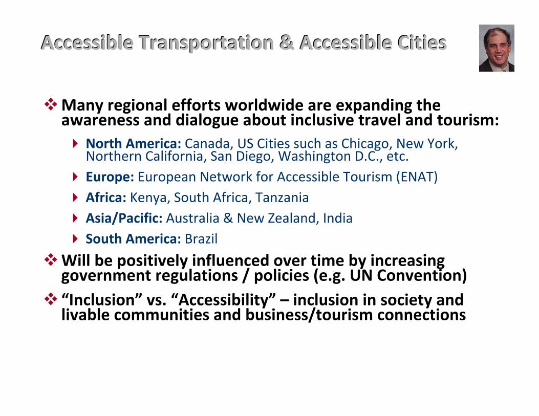
Accessible Transportation & Accessible CitiesAccessible Transportation & Accessible Cities
�Many regional efforts worldwide are expanding theawareness and dialogue about inclusive travel and tourism: � North America: Canada, US Cities such as Chicago, New York,
Northern California, San Diego, Washington D.C., etc. � Europe: European Network for Accessible Tourism (ENAT) � Africa: Kenya, South Africa, Tanzania � Asia/Pacific: Australia & New Zealand, India � South America: Brazil
�Will be positively influenced over time by increasinggovernment regulations / policies (e.g. UN Convention)
� “Inclusion” vs. “Accessibility” – inclusion in society andlivable communities and business/tourism connections
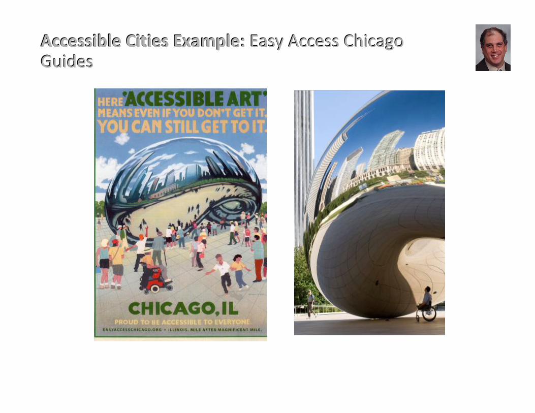
Accessible Cities Example: Accessible Cities Example: Easy Access Chicago Easy Access ChicagoGuidesGuides
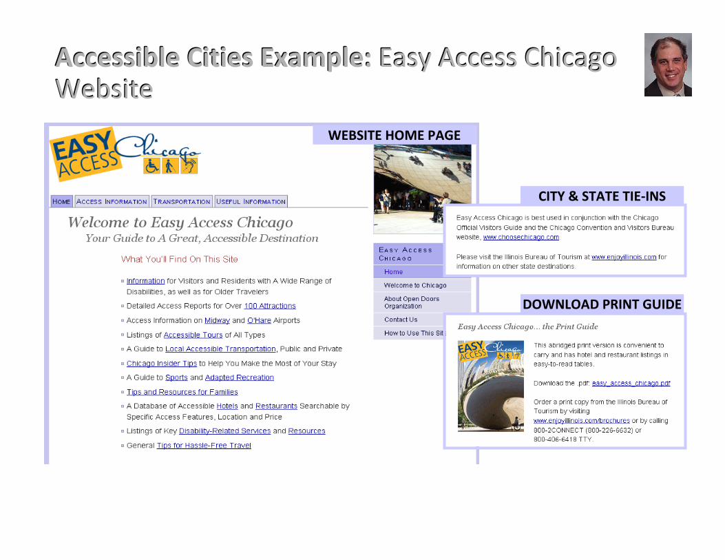
Accessible Cities Example: Accessible Cities Example: Easy Access Chicago Easy Access ChicagoWebsiteWebsite
WEBSITE HOME PAGE
CITY & STATE TIE-INS
DOWNLOAD PRINT GUIDE
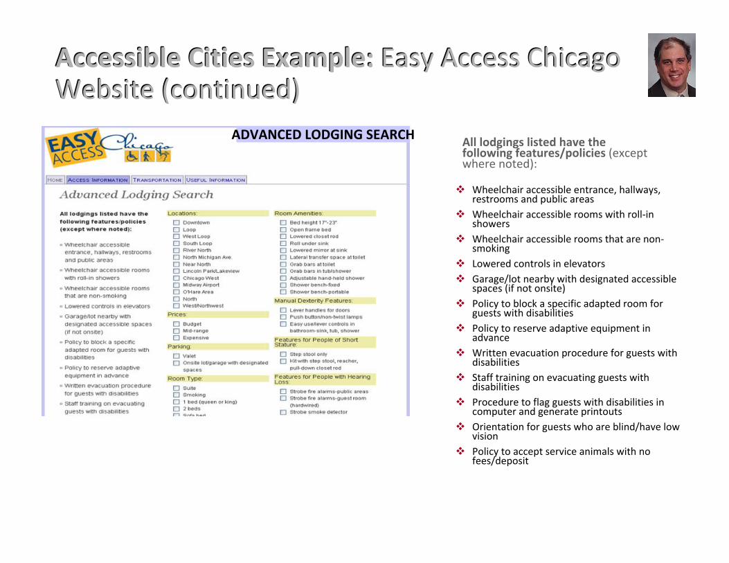
Accessible Cities Example: Accessible Cities Example: Easy Access Chicago Easy Access ChicagoWebsite (continued)Website (continued)
ADVANCED LODGING SEARCH All lodgings listed have thefollowing features/policies (exceptwhere noted):
� Wheelchair accessible entrance, hallways, restrooms and public areas
� Wheelchair accessible rooms with roll-in showers
� Wheelchair accessible rooms that are non-smoking
� Lowered controls in elevators � Garage/lot nearby with designated accessible
spaces (if not onsite) � Policy to block a specific adapted room for
guests with disabilities � Policy to reserve adaptive equipment in
advance � Written evacuation procedure for guests with
disabilities � Staff training on evacuating guests with
disabilities � Procedure to flag guests with disabilities in
computer and generate printouts � Orientation for guests who are blind/have low
vision � Policy to accept service animals with no
fees/deposit
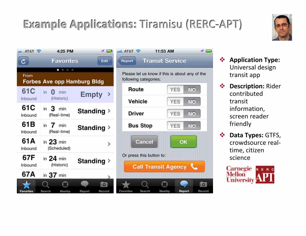
Example Applications:Example Applications: Tiramisu (RERC-APT)Tiramisu (RERC-APT)
� Application Type: Universal design transit app
� Description: Rider contributed transit information, screen reader friendly
� Data Types: GTFS, crowdsource real-time, citizen science
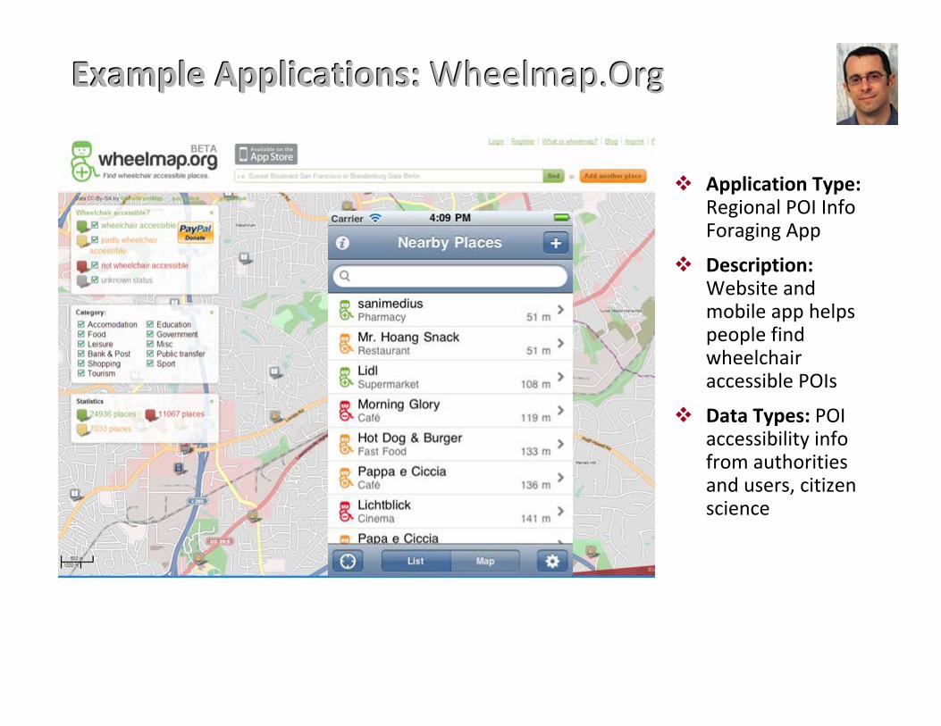
Example Applications: Example Applications: Wheelmap.OrgWheelmap.Org
� Application Type: Regional POI Info Foraging App
� Description: Website and mobile app helps people find wheelchair accessible POIs
� Data Types: POI accessibility info from authorities and users, citizen science
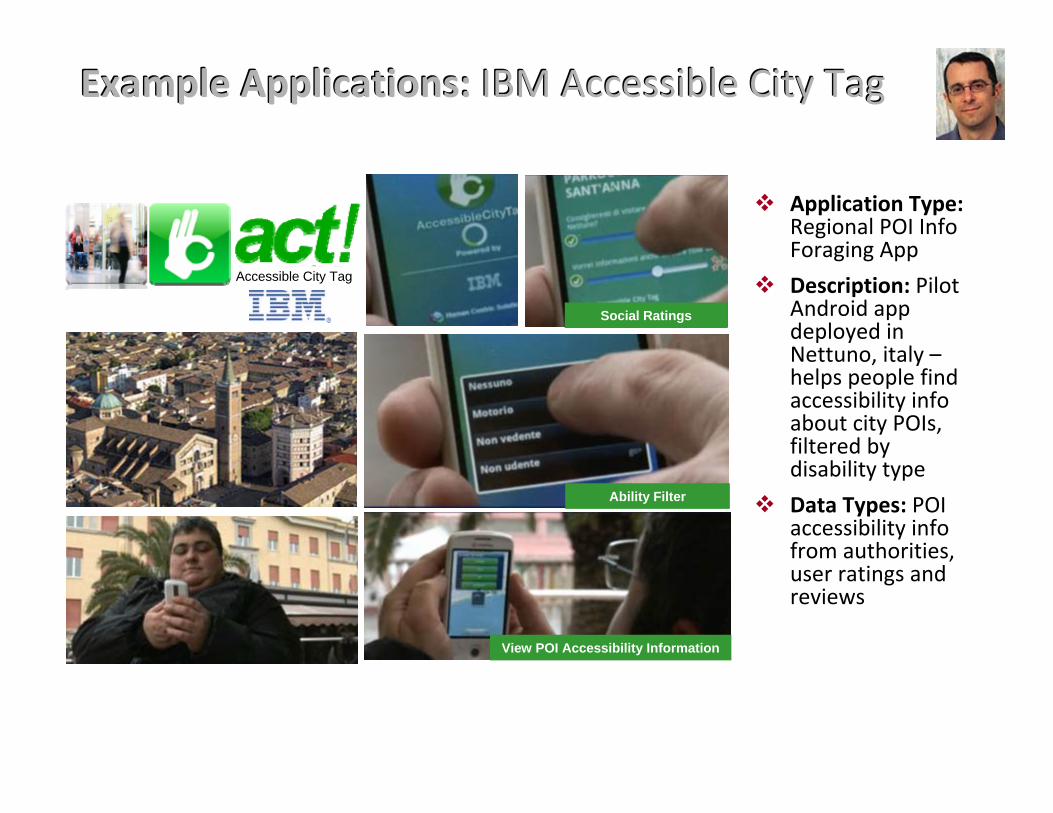
Example Applications: Example Applications: IBM Accessible City TagIBM Accessible City Tag
Accessible City Tag
View POI Accessibility Information
Social Ratings
Ability Filter
� Application Type: Regional POI Info Foraging App
� Description: Pilot Android app deployed in Nettuno, italy – helps people find accessibility info about city POIs, filtered by disability type
� Data Types: POI accessibility info from authorities, user ratings and reviews
Policy BackgroundPolicy Background
�Accessible transportation is essential to inclusion
�ADA Regulations on Public Transit �Vehicle-based information display & announcement
(including external)
�Accessible stop requests
�Section 508
�Upcoming changes to ADA on ICT �Web
�Equipment & furniture
Policy RecommendationsPolicy Recommendations
�For all federally funded transportation R&D and implementation projects:�Open, inclusive data in standard formats
�Accessible points-of-interest (POIs)
�Real-time status (e.g., elevator outages)
�508-compliant technologies & user interfaces, including crowdsourcing interfaces
�Research to improve understanding of user needs and preferences
Moderated Q&A SessionModerated Q&A Session
�Regulatory & User Needs
�Market Environment & Accessible Cities
�Data Sharing Infrastructure
�The Need for Applied Research
�Role of Transportation & City Authorities
How You Can Get InvolvedHow You Can Get Involved
�Policymakers: Address this issue in policy / key is ensuring open data, funding of projects, etc.
�R&D: Pursue projects in this area
�Transportation Authorities & Other Data Owners: Provide open data and encourage app development
�Citizens: Assist and support accessible cities efforts / data gathering and serve as citizen scientists, co-designers
�ICT Developers: Include accessibility information and accessible user interfaces in your products and services
�We encourage all parties to: �Review Data-Enabled Travel Report
(http://www.geoaccess.org/content/report-data-enabled-travel)
�Attend Kareem Dale’s address tomorrow for a special note about government activities in this area!