achievements off the sentinel asia … of sentinel asia suc story in the philip arturo s. daag...
TRANSCRIPT

ACHIEVEMENTS OFACHIEVEMENTS OFSENTINEL ASIA SUCSENTINEL ASIA SUCSTORY IN THE PHILIPSTORY IN THE PHILIPArturo S. Daag
Philippine Institute of Volcanology and Seismology (PHIVOLCS)
F THE F THE CCESS CCESS PPINESPPINES

SENTINEL ASIA SUCCESS SSummary of Acti
STEP 1Training on Remote Sensing for disastRADAR)RADAR)• Local Case Studies
• Flood, Landslide, Volcano-LAHA• Sentinel Asia EOR Training and suc
STEP 2 STEP 2 Training on InSAR Processing and Sate• Local Case Studies• Local Case Studies
• Ground subsidence in Metro Ma• Ground deformation monitoringg• Landslide warning system using
STORY IN THE PHILIPPINESvities : 2009-2013
er application (Multi-spectral and
ARcceeding actual operations
ellite-based Rainfall (GSMAP)
anilag of active volcanog RBN Network

STEP 1 2009 CAPACITY BUILDIN(OPTICAL AN(OPTICAL AN
NG ON IMAGE PROCESSING ND RADAR)ND RADAR)

STEP 1 Product: Createwith the use of ALOS
Flood - Antique Province (MGB)
Flood - Iloilo City(PAGASA)(PAGASA)
ed/Revised Hazard MapsS Satellite Data (2010)
Lahar – Mayon Volcano
( )
y(PHIVOLCS)

STEP 1 LAHARZ Modelingg Results Using ALOS DEM

STEP 1: Capacity BuiOb tiObservatio
lding on Emergency R ton Request
When disaster happens, Sentinel Asia can accept Emergency ObservationEmergency Observation Request (EOR) from users, and Space Agency , p g yobserves disaster afflicted area by Satellite. Then
lli isatellite imagery are provided to users.

STEP 1 EOR: Flooding relain Botolan Zambales Lin Botolan, Zambales, Luz
Fl dFloode
January 27, 2009
ated to SW monsoon rains on Island A g st 8 2009zon Island, August 8, 2009
Overflow point; dike d
pbreacheded areas
August 11, 2009

STEP 1 EOR: Typhooon Ketsana Flooding
Source: pinoymoneytalk.com

STEP 1 EOR: Flooding relaOndoy (KETSANA)Ondoy (KETSANA)
EASTERN MEEASTERN MESOUTHERN BU
June 26, 2009Before Ketsana
ated to Tropical Cyclones September 2009, September 2009
ETRO MANILA ANDETRO MANILA AND ULACAN PROVINCE
September 26, 2009 During Passage of Ketsana

STEP 1 EOR: MAYON VO2009 ERUPTION LAVA FL2009 ERUPTION LAVA FL
• hazamonit
•
2009
monitof volu
1993
2006
of erumater
2006 for volca
ALOS Dec 25, 2009Lava Flow: 4.4km
activitassess
OLCANO DECEMBER OW MONITORINGOW MONITORING
ard oring
oring ume pted rials
nic ty sment
Helicopter, Jan 6, 2009Lava Flow: 4.7 km

ALOS DEM LAVA VOLUME ESTIMATION FROM OOCT 2009 AND DEC 25, 2009
ALOS PRE- and POST LAVA FLOW DEMLava flow (Dec 25, 2009)Length = 4 3km from SummitLength 4.3km from SummitArea = 849,000 m2Volume = 6,209,200

STEP 1 EOR: TypDec 16-17, 2011
phoon BhopaDec 16 17, 2011 TY Sendong
BARANGAY MACANDASIG, A POINT BAR DEPOSIT, WAS DEVELOPED FOR DEVELOPED FOR HOUSING. POST-DISASTER IMAGE FROM THEOS SHOWING THE COMPLETELY COMPLETELY DEVASTATED POINT BAR AREA.
Ground photos Ground photos of Barangay Macandasig, Cagayan de Oro City. Flashflood Flashflood completely swept the village and flood water depth is more than 3 meters.

STEP 2 (2010 – 2012)Training on InSAR Processing and Sattellite-based Rainfall (GSMAP)

STEP 2 Subsidence: Metro Manila
A
CC
D
B
E
14

STEP 2 Subsidence: Metro Manila
A
CC
D
2011 –Feb.2007 (1472 Days)
B
E
15

EP 2 Subsidence: Metro Manila Four ywith Supplemental GPS Data
Original
12010/11/14 2007/24
132011/3/3 2007/2Conversion
2010/11/112010/11/14 2007/2
132011/3/3 2007/2AverageAverage
years from 2007-2010
A B C D E
2/3 1380 - -30 - - 122/20 1472 -40 -27 -20 -12 7.5
2/3 1460 - -32 - - 132/20 1460 -40 -27 -20 -12 7
4 years -39.7 -29.3 -19.8 -11.9 10.11 year -9.9 -7.3 -5.0 -3.0 2.5
16

STEP 2 INSAR: STUDY ARSTEP 2 INSAR: STUDY AR
Location: Province of Albay, BicolElevation: 2.46 km a.s.l. Base Diameter: ~20 kmVolcano Type: Stratovolcano
EA: MAYON VOLCANOEA: MAYON VOLCANO
Photo courtesy of Ed Laguerta (aerial survey: Aug., 2009)

STEP 2: Ground Deform
Close (Uplift)
Far (Deformation)
mation on VolcanoClose to Satellite
1 Cycle =1 Cycle =Walelength/2
(11.8cm)≒Vertical 15cm≒Vertical 15cm
F fFar fromSatellite
18

STEP 2: Use of GSMAP inFlood and LandslideFlood and Landslide
n rainfall Monitoring for

TEP 2: Use of GSMAP in rainfall M it i f Fl d d L d lidMonitoring for Flood and Landslid
nel Asia success story in the Philippines
dde
GSMaP
CL : 0.5YScattered data.

Calibration: AlbayMay 7, 2011Landslide
0.8
FebLandslide
0 6
0.50.5
0.5
0.60.4 0.5 0.5
0.5 0.4
0.5
0.5 0.5 0.5
0.5 0.70.5 0.50.5
0.70.5
0.5 0.5 0.5 0.70.7
nel Asia success story in the Philippines
JaLa
Jul 25-27, 2011TS with Monsoon
(GSMaP and AWS) CL0 1L
0.2
0.1b 12, 2012 Landslide
July 25-27, 2011
0.3Mt.Malinao
July 25-27, 2011Mt Masaraga 0.4
0 5
0.55
5 0.5 0.5 0.5 0.5
Mt.Masaraga
0.5
0.67 0.50.75 Dec 29, 2010
Landslide
0.70.77 0.7
Landslide
0.8
0 90.6
22
0.9an, 2011andslide

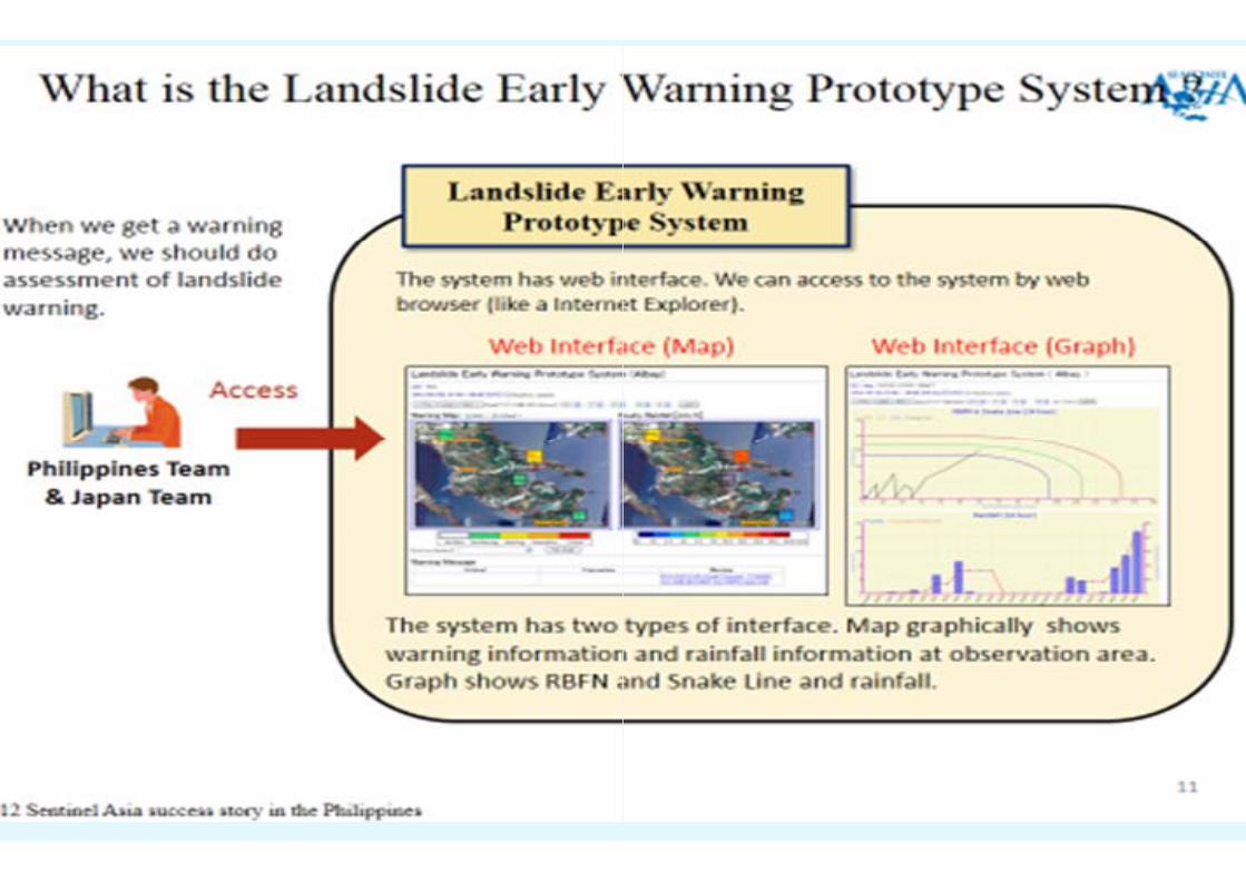
STEP 2: Operational LandslideE t bli h d L d lid W iEstablished Landslide WarninTokyo Office Website htt //60 36 183 126/l W ihttp://60.36.183.126/lsWarnin
e Warning t NTT D t ng server at NTT Data
/ng/

THANK YOUTHANK YOU