ad 2.lfll ad 2 lfll adc 01 ad 2 lfll adc 02 ad …frenchproatc118.300.free.fr/doc/lyon ifr.pdf ·...
TRANSCRIPT
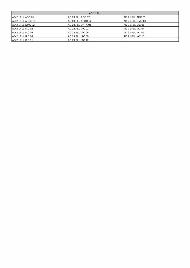
AD 2.LFLL
AD 2 LFLL ADC 01 AD 2 LFLL ADC 02 AD 2 LFLL ADC 03
AD 2 LFLL APDC 01 AD 2 LFLL APDC 02 AD 2 LFLL GMC 01
AD 2 LFLL GMC 02 AD 2 LFLL DATA 01 AD 2 LFLL IAC 01
AD 2 LFLL IAC 02 AD 2 LFLL IAC 03 AD 2 LFLL IAC 04
AD 2 LFLL IAC 05 AD 2 LFLL IAC 06 AD 2 LFLL IAC 07
AD 2 LFLL IAC 08 AD 2 LFLL IAC 09 AD 2 LFLL IAC 10
AD 2 LFLL IAC 11 AD 2 LFLL IAC 12
Terminal
Gare SNCF
Railway station
PAPI 3.0° (5.2%)
MEHT 68
Tranchée TGV
TGV cutting
Terminal de fret
Cargo terminal
GP / DME
LOC
1001(181)
PAPI 3.0° (5.2%)
MEHT 52
GP / DME
VOR/DME
LOC765
788
TWR
18 L
18 R
821
780
758
175°
175°
GP / DME
867(47)
355°355°
LOC
4000 x 45 m
2670 x 45 m
813
P
P
P
P
B
36 L36 L
C
FE
D1D2
992
P
P
A2
A1
Zone non roulable (voir APDC)
Unusable taxiing area (see APDC)
Terminal 36 R36 R
005° 03�
45°
43�
45°
44�
45°
45'
005° 05� 005° 06� 005° 07�005° 04�
45°
42�005° 08�
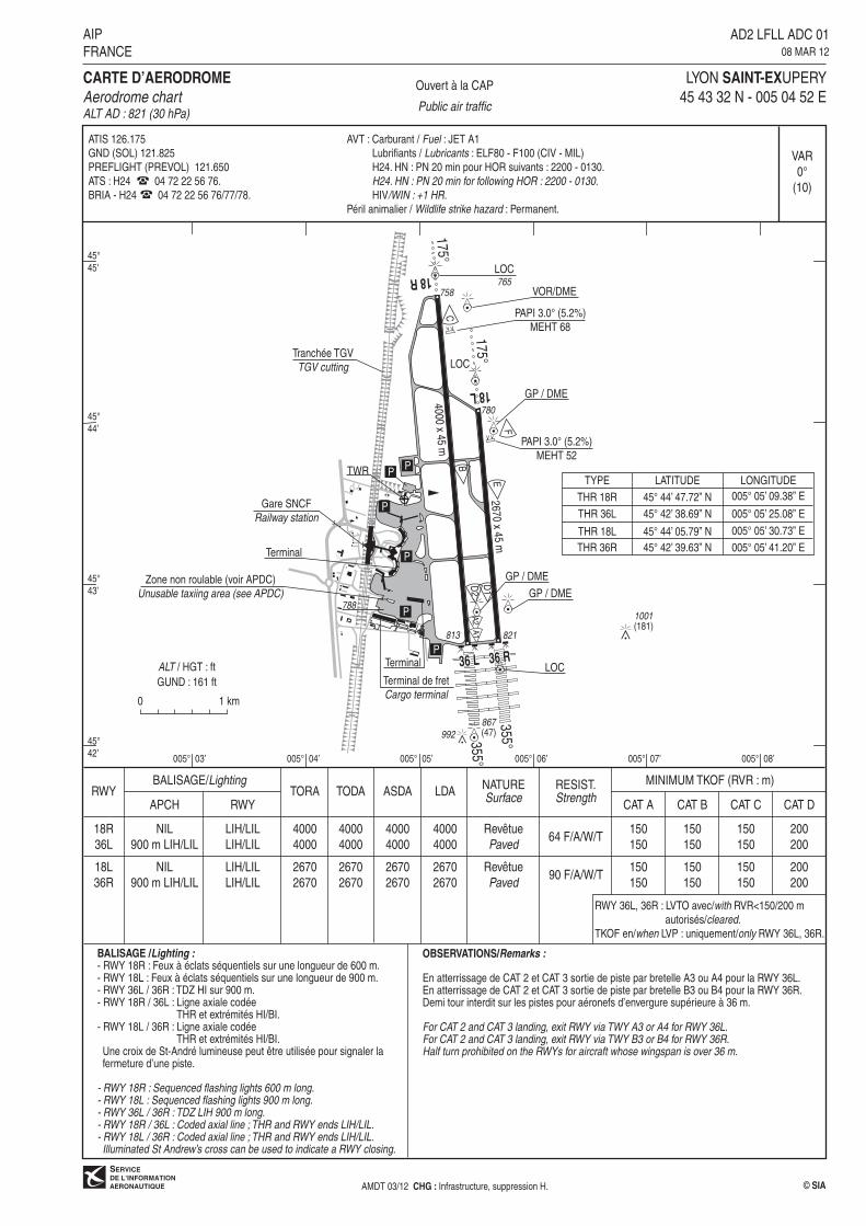
Ouvert à la CAP
Public air traffic
LYON SAINT-EXUPERY
45 43 32 N - 005 04 52 E
CARTE D�AERODROME
Aerodrome chartALT AD : 821 (30 hPa)
AD2 LFLL ADC 0108 MAR 12
AIP
FRANCE
© SIA
VAR
0°
(10)
ALT / HGT : ft
GUND : 161 ft
BALISAGE/Lighting
APCH RWYTORA TODA ASDA LDARWY
18R
36L
NIL
900 m LIH/LIL
LIH/LIL
LIH/LIL
4000
4000
4000
4000
4000
4000
4000
4000
NATURESurface
MINIMUM TKOF (RVR : m)
64 F/A/W/T
CAT A CAT B
RESIST.Strength
Revêtue
Paved
CAT C CAT D
BALISAGE /Lighting :- RWY 18R : Feux à éclats séquentiels sur une longueur de 600 m.- RWY 18L : Feux à éclats séquentiels sur une longueur de 900 m.- RWY 36L / 36R : TDZ HI sur 900 m.- RWY 18R / 36L : Ligne axiale codée THR et extrémités HI/BI.- RWY 18L / 36R : Ligne axiale codée
THR et extrémités HI/BI. Une croix de St-André lumineuse peut être utilisée pour signaler la fermeture d�une piste.
- RWY 18R : Sequenced flashing lights 600 m long.- RWY 18L : Sequenced flashing lights 900 m long.- RWY 36L / 36R : TDZ LIH 900 m long.- RWY 18R / 36L : Coded axial line ; THR and RWY ends LIH/LIL.- RWY 18L / 36R : Coded axial line ; THR and RWY ends LIH/LIL. Illuminated St Andrew�s cross can be used to indicate a RWY closing.
OBSERVATIONS/Remarks :
En atterrissage de CAT 2 et CAT 3 sortie de piste par bretelle A3 ou A4 pour la RWY 36L.En atterrissage de CAT 2 et CAT 3 sortie de piste par bretelle B3 ou B4 pour la RWY 36R.Demi tour interdit sur les pistes pour aéronefs d�envergure supérieure à 36 m.
For CAT 2 and CAT 3 landing, exit RWY via TWY A3 or A4 for RWY 36L.For CAT 2 and CAT 3 landing, exit RWY via TWY B3 or B4 for RWY 36R.Half turn prohibited on the RWYs for aircraft whose wingspan is over 36 m.
ATIS 126.175
GND (SOL) 121.825
PREFLIGHT (PREVOL) 121.650
ATS : H24 04 72 22 56 76.
BRIA - H24 04 72 22 56 76/77/78.
90 F/A/W/T
TYPE LATITUDE LONGITUDE
THR 18R 45° 44� 47.72� N 005° 05� 09.38� E
THR 36L 45° 42� 38.69� N 005° 05� 25.08� E
THR 18L 45° 44� 05.79� N 005° 05� 30.73� E
THR 36R 45° 42� 39.63� N 005° 05� 41.20� E
150
150
150
150
150
150
200
200
RWY 36L, 36R : LVTO avec/with RVR<150/200 m
autorisés/cleared.
TKOF en/when LVP : uniquement/only RWY 36L, 36R.
0 1 km
AVT : Carburant / Fuel : JET A1
Lubrifiants / Lubricants : ELF80 - F100 (CIV - MIL)
H24. HN : PN 20 min pour HOR suivants : 2200 - 0130.
H24. HN : PN 20 min for following HOR : 2200 - 0130.
HIV/WIN : +1 HR.
Péril animalier / Wildlife strike hazard : Permanent.
18L
36R
NIL
900 m LIH/LIL
LIH/LIL
LIH/LIL
2670
2670
2670
2670
2670
2670
2670
2670
Revêtue
Paved
150
150
150
150
150
150
200
200
AMDT 03/12 CHG : Infrastructure, suppression H.
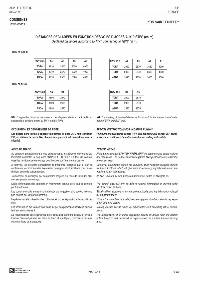
DISTANCES DECLAREES EN FONCTION DES VOIES D’ACCES AUX PISTES (en m)Declared distances according to TWY connecting to RWY (in m)
CONSIGNESLYON SAINT EXUPERY
Instructions
AD2 LFLL ADC 02 AIP08 MAR 12 FRANCE
RWY 36 L/18 R :
RWY 36 R/18 L :
AMDT 03/12 © SIA
RWY 36 R B6 B7
TORA 1690 2670
TODA 1690 2670
ASDA 1690 2670
RWY 18 L B4 B3
TORA 2090 2670
TODA 2090 2670
ASDA 2090 2670
RWY 36 L A4 A5 A6 A7
TORA 1910 2570 3020 4000
TODA 1910 2570 3020 4000
ASDA 1910 2570 3020 4000
NB : L’origine des distances déclarées au décollage est située au droit de l’inter-section de la bordure amont du TWY et de la RWY.
OCCUPATION ET DEGAGEMENT DE PISTE
Les pilotes sont invités à dégager rapidement la piste 36R, hors condition LVP, en utilisant la sortie W4, chaque fois que ceci est compatible avec lasécurité.
AIRES DE TRAFIC
Au départ et préalablement à tous déplacements, les aéronefs doivent obliga-toirement contacter la fréquence “SAINT-EX PREVOL”. La tour de contrôleorganise la séquence de roulage pour l’entrée sur l’aire de manœuvre.
A l’arrivée, les aéronefs contacteront la fréquence assignée par la tour decontrôle qui leur indiquera les éventuelles consignes et informations pour rejoin-dre leur poste de stationnement.
Tout aéronef se déplaçant par ses propres moyens sur l’aire de trafic doit allu-mer ses phares de roulage.
Seule l’information des aéronefs en mouvement connus de la tour de contrôlepeut être fournie.
Les postes de stationnement sont attribués par le gestionnaire et cette informa-tion relayée par la tour de contrôle.
Le pilote assure la prévention des collisions, sa propre séparation et la sécurité destiers.
Les véhicules en mouvement sont conduits par des personnes habilitées, surveil-lant leur environnement.
La responsabilité des organismes de la circulation aérienne cesse, à l’arrivée,lorsque l’aéronef pénètre sur l’aire de trafic et, au départ, commence dès qu’ilentre sur l’aire de manœuvre.
NB: The starting of declared distances for take-off is the intersection of outer
edge of TWY and RWY end.
SPECIAL INSTRUCTIONS FOR VACATING RUNWAY
Pilots are encouraged to vacate RWY 36R expeditiously except LVP condi-
tions, via exit W4 each time it is possible according with safety.
TRAFFIC AREAS
Aircraft must contact “SAINT-EX PREFLIGHT” on departure and before making
any manœuvre. The control tower will organize taxiing sequences to enter the
movement area.
On arrival, aircraft must contact the frequency which has been assigned to them
by the control tower which will give them, if necessary, any information and ins-
tructions to join their stands.
All ACFT moving by own means on apron must switch its taxilights on.
The control tower will only be able to transmit information on moving traffic
which is known to them.
Stands will be allocated by the managing authority and this information relayed
by the control tower.
Pilots will ensure their own safety concerning ground collision avoidance, sepa-
ration and third parties.
Moving vehicles will be driven by experienced staff exercising visual surveil-
lance.
The responsibility of air traffic organisms ceases on arrival when the aircraft
enters the apron and, on departure begins as soon as it enters the manœuvring
area.
RWY 18 R A4 A3 A2 A1
TORA 2090 2870 3660 4000
TODA 2090 2870 3660 4000
ASDA 2090 2870 3600 4000
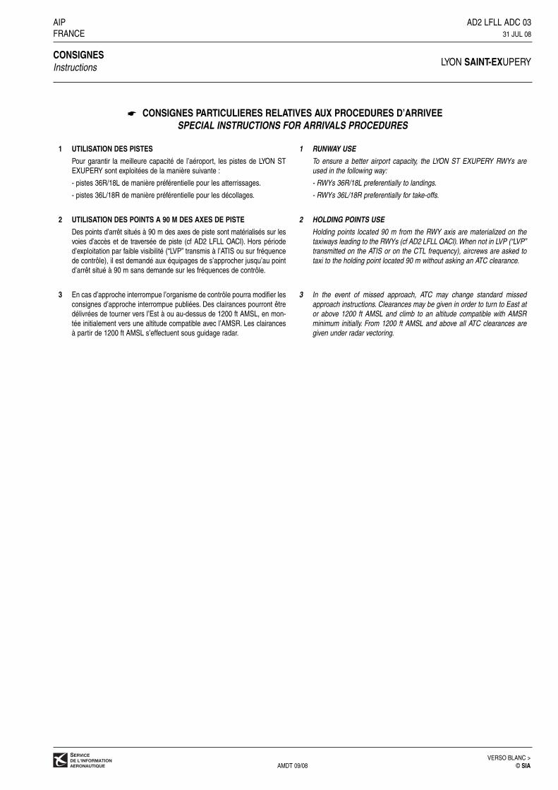
CONSIGNES PARTICULIERES RELATIVES AUX PROCEDURES D’ARRIVEESPECIAL INSTRUCTIONS FOR ARRIVALS PROCEDURES
AIP AD2 LFLL ADC 03FRANCE 31 JUL 08
CONSIGNESLYON SAINT-EXUPERYInstructions
VERSO BLANC >AMDT 09/08 © SIA
1 UTILISATION DES PISTES
Pour garantir la meilleure capacité de l’aéroport, les pistes de LYON STEXUPERY sont exploitées de la manière suivante :
- pistes 36R/18L de manière préférentielle pour les atterrissages.
- pistes 36L/18R de manière préférentielle pour les décollages.
2 UTILISATION DES POINTS A 90 M DES AXES DE PISTE
Des points d’arrêt situés à 90 m des axes de piste sont matérialisés sur lesvoies d’accès et de traversée de piste (cf AD2 LFLL OACI). Hors périoded’exploitation par faible visibilité (“LVP” transmis à l’ATIS ou sur fréquencede contrôle), il est demandé aux équipages de s’approcher jusqu’au pointd’arrêt situé à 90 m sans demande sur les fréquences de contrôle.
3 En cas d’approche interrompue l’organisme de contrôle pourra modifier lesconsignes d’approche interrompue publiées. Des clairances pourront êtredélivrées de tourner vers l’Est à ou au-dessus de 1200 ft AMSL, en mon-tée initialement vers une altitude compatible avec l’AMSR. Les clairancesà partir de 1200 ft AMSL s’effectuent sous guidage radar.
1 RUNWAY USE
To ensure a better airport capacity, the LYON ST EXUPERY RWYs areused in the following way:
- RWYs 36R/18L preferentially to landings.
- RWYs 36L/18R preferentially for take-offs.
2 HOLDING POINTS USE
Holding points located 90 m from the RWY axis are materialized on thetaxiways leading to the RWYs (cf AD2 LFLL OACI). When not in LVP (“LVP”transmitted on the ATIS or on the CTL frequency), aircrews are asked totaxi to the holding point located 90 m without asking an ATC clearance.
3 In the event of missed approach, ATC may change standard missedapproach instructions. Clearances may be given in order to turn to East ator above 1200 ft AMSL and climb to an altitude compatible with AMSRminimum initially. From 1200 ft AMSL and above all ATC clearances aregiven under radar vectoring.
☛
TERMINAL CHARTER
A5
B63
B82
B83
B91
B93
C23
C41
C42
C61
C63
F9
C22
B92
C43
C83
C62
B81 B
73B
71B
62
B61
F7
T5
T4
K1
K3
TERMINAL 1
TC
TB
TA
TD A
6
T6
T7
TJ
F
T S
E
E
A21
A24A23
A22
B10B12
B14B16
B18
A25
A29
A27
A26A28
A30
A36
A31
A35
A34
A33
A32
N
C21
C81C82
B72
TERMINAL DE FRET / CARGO TERMINAL
F6 F5
F4 F3
F2
J19
J14
J17J15
J13J11
K52
K32
K54
K33
K31
K11
E11
E13
E15
E17
D37
R1
R2
D45
D43
D11
D13
TL
TL
TS
T J
Zone non roulableUnusable taxiing area
TERMINAL 3
J41 J39 J37 J35 J33
L19L17
L15 L13
L14
TERMINAL 2
J32
L11
J31
Aire de traficApron
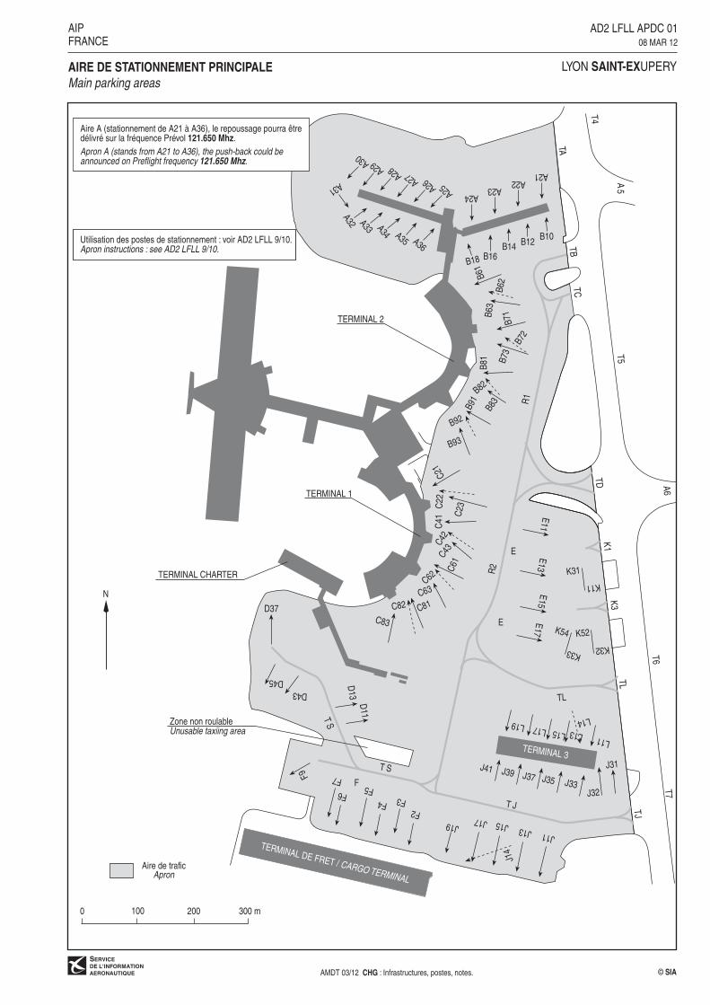
LYON SAINT-EXUPERYAIRE DE STATIONNEMENT PRINCIPALE
Main parking areas
AIPFRANCE
© SIAAMDT 03/12 CHG : Infrastructures, postes, notes.
AD2 LFLL APDC 0108 MAR 12
300 m0 100 200
Aire A (stationnement de A21 à A36), le repoussage pourra êtredélivré sur la fréquence Prévol 121.650 Mhz.
Apron A (stands from A21 to A36), the push-back could beannounced on Preflight frequency 121.650 Mhz.
Utilisation des postes de stationnement : voir AD2 LFLL 9/10.Apron instructions : see AD2 LFLL 9/10.

M11
M12
36
LA7A7
N
TMTM
N11N11 N31
N32
N33
N34
N12
N13
N14
N21
N22
N23
N24
N41
N42
N43
N44
M13
TN2TN1 TN3
PRKG GAviation généraleGeneral aviation
Locindus Locindus
T4T3
A4
N
LYON SAINT-EXUPERYAIRES DE STATIONNEMENT M - N
Parking areas M - N
AIPFRANCE
© SIAAMDT 03/12 CHG : NIL.
AD2 LFLL APDC 0208 MAR 12
Aire de traficApron
100 m0 50
Aire de traficApron
100 m0 50
18 R
18 L
A2
G
36 R
36 L
T5T5
T6
B
C
D
FJ
S
K
TDTD
TCTC
T7
T7
A
TATA
TBTB
E
K1
K3
TL
TJ
A1A1
A2
T1T1
T2T2
W4
Point d�arrêtintermédiaire
Intermediateholding point
Point d�arrêtHolding point
M
T4T4
N
T3
A4A4
B4B4
TN1
TN2
TN3
A7A7
B3B3A3A3
A6A6
A5A5
B6B6
B7B7
TM
Aire S uti l isable comme zone d�attente et dedépassement pour tous les aéronefs d�envergure < 34m.
Area S usable as Holding area and overtaking areafor all ACFT with wingspan <34m.
A2A2
N
0 500 m
© SIAAMDT 03/12 CHG : Infrastructures, notes.
LYON SAINT-EXUPERY
AIPFRANCE
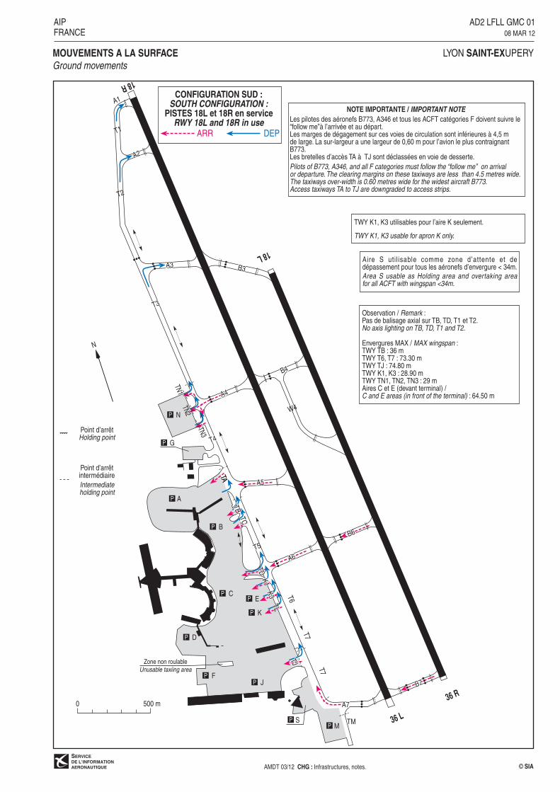
AD2 LFLL GMC 0108 MAR 12
TWY K1, K3 utilisables pour l�aire K seulement.
TWY K1, K3 usable for apron K only.
MOUVEMENTS A LA SURFACE
Ground movements
CONFIGURATION SUD :
SOUTH CONFIGURATION :PISTES 18L et 18R en service
RWY 18L and 18R in useARR DEP
Observation / Remark :Pas de balisage axial sur TB, TD, T1 et T2.No axis lighting on TB, TD, T1 and T2.
Envergures MAX / MAX wingspan :TWY TB : 36 mTWY T6, T7 : 73.30 mTWY TJ : 74.80 mTWY K1, K3 : 28.90 mTWY TN1, TN2, TN3 : 29 mAires C et E (devant terminal) /C and E areas (in front of the terminal) : 64.50 m
NOTE IMPORTANTE / IMPORTANT NOTE
Les pilotes des aéronefs B773, A346 et tous les ACFT catégories F doivent suivre le�follow me�à l�arrivée et au départ.Les marges de dégagement sur ces voies de circulation sont inférieures à 4,5 mde large. La sur-largeur a une largeur de 0,60 m pour l�avion le plus contraignantB773.Les bretelles d�accès TA à TJ sont déclassées en voie de desserte.
Pilots of B773, A346, and all F categories must follow the �follow me� on arrivalor departure. The clearing margins on these taxiways are less than 4.5 metres wide.The taxiways over-width is 0.60 metres wide for the widest aircraft B773.Access taxiways TA to TJ are downgraded to access strips.
Zone non roulable
Unusable taxiing area
18 R
18 L
A2
G
36 R
36 L
T5T5
T6
B
C
D
FJ
S
K
TDTD
TCTC
T7
T7
A
TATA
TBTB
E
K1
K3
TL
TJ
T3
A1A1
T1T1
T2T2
A3A3 B3B3
W4
A5A5
A6A6
B6B6
B7B7
A7A7
Point d�arrêtintermédiaire
Intermediateholding point
Point d�arrêtHolding point
NTN
1TN
2
TN3
T4T4
A4A4
B4B4
M TM
Aire S uti l isable comme zone d�attente et dedépassement pour tous les aéronefs d�envergure < 34m.
Area S usable as Holding area and overtaking areafor all ACFT with wingspan <34m.
A2A2
N
0 500 m
© SIAAMDT 03/12 CHG : Infrastructures, notes.
LYON SAINT-EXUPERY
AIPFRANCE
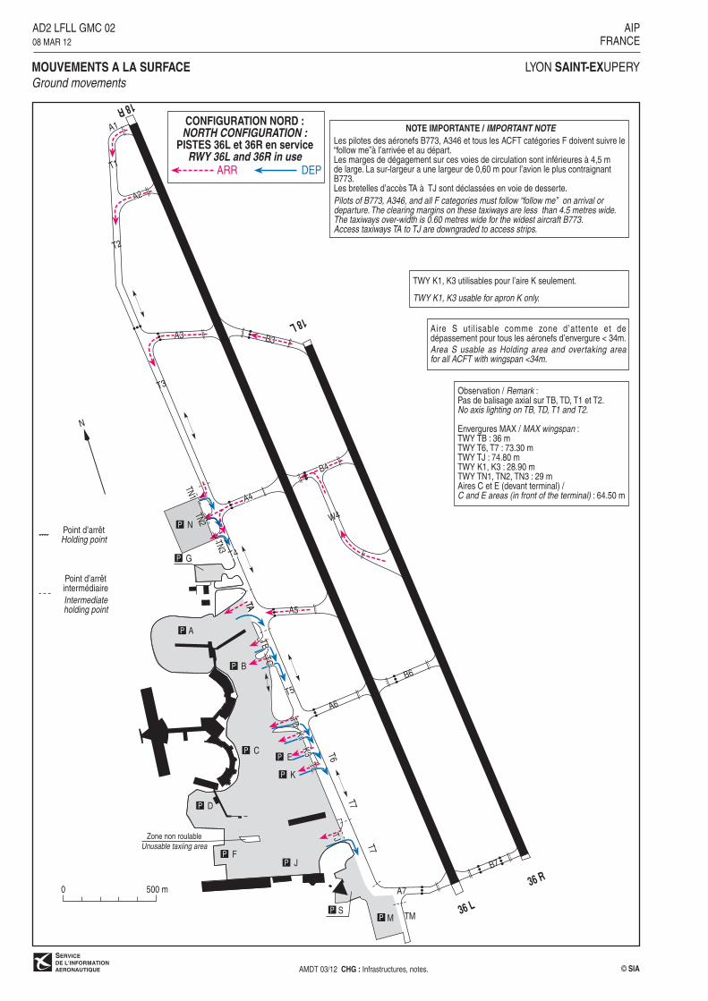
AD2 LFLL GMC 0208 MAR 12
TWY K1, K3 utilisables pour l�aire K seulement.
TWY K1, K3 usable for apron K only.
MOUVEMENTS A LA SURFACE
Ground movements
CONFIGURATION NORD :
NORTH CONFIGURATION :PISTES 36L et 36R en service
RWY 36L and 36R in useARR DEP
Observation / Remark :Pas de balisage axial sur TB, TD, T1 et T2.No axis lighting on TB, TD, T1 and T2.
Envergures MAX / MAX wingspan :TWY TB : 36 mTWY T6, T7 : 73.30 mTWY TJ : 74.80 mTWY K1, K3 : 28.90 mTWY TN1, TN2, TN3 : 29 mAires C et E (devant terminal) /C and E areas (in front of the terminal) : 64.50 m
Zone non roulable
Unusable taxiing area
NOTE IMPORTANTE / IMPORTANT NOTE
Les pilotes des aéronefs B773, A346 et tous les ACFT catégories F doivent suivre le�follow me�à l�arrivée et au départ.Les marges de dégagement sur ces voies de circulation sont inférieures à 4,5 mde large. La sur-largeur a une largeur de 0,60 m pour l�avion le plus contraignantB773.Les bretelles d�accès TA à TJ sont déclassées en voie de desserte.
Pilots of B773, A346, and all F categories must follow �follow me� on arrival ordeparture. The clearing margins on these taxiways are less than 4.5 metres wide.The taxiways over-width is 0.60 metres wide for the widest aircraft B773.Access taxiways TA to TJ are downgraded to access strips.

AIP AD2 LFLL DATA 01FRANCE 25 AUG 11
DATA LYON SAINT-EXUPERY
POINTS / REPERES ESSENTIELS DES PROCEDURES CONVENTIONNELLESWaypoints / Conventional procedures main fixes
IDENTIFICATION / FONCTION
IDENTIFICATION / FUNCTION
COORDONNEES
COORDINATES
ARBON-IAF 45° 16’ 59.8”N - 004° 53’ 24.6”E
GOMET-IAF 45° 21’ 36.7”N - 005° 29’ 16.8”E
RUNOM-IAF 46° 03’ 45.6”N - 005° 21” 13.9”E
TALAR-IAF 45° 57’ 23.0”N - 004° 36’ 15.7”E
VNE-IAF 45° 33’ 23.2”N - 004° 53’ 00.3”E
VERSO BLANC >AMDT 09/11 CHG : Suppression WS IAF © SIA
2000
2000
2000
2000
2000
2000
2000
4000
2000
4000
3000
3000
3000
LSS Ch 28 X
(109.1)
L. BRON
1044
945
738971
827
1234
1694
977919
3094
3009
2051
2225
3474
2159
IF
210°
030°
030°
LSE
29LS
E
24LS
E
16 LSE
301°
121°
FL 070 / 4500
13 LSE
11LS
E
11 LSE
301° LSE
346° LSE
3000
3000
4000
4000
121°
3452
3183
175°
3000
V. TARARE
BOURG
2720
210°
5000
22 LSE
27 LSE
PROTECTIONIAS : 220 ktZP : 14000
PROTECTIONIAS : 220 ktZP : 14000
IAF
RUNOM
IAF
TALAR
FL 100 MAX
IAS MAX 190 kt
IAS MAX 190 kt
13LS
E
004°
LS
E
TR 344
LSE 114.75
Ch 94 Y
VNE 108.2
196°
016°FL
100
/ 500
0
34 LSE
29 LSE
IAF
ARBON
PROTECTIONIAS : 220 ktZP : 14000
359°
FL 100 / 5000
357°
FL 100 / 5000
241° LSE
FL 100 FL 070
FL 070 / 5000
298° LSEFL 070 3000
FL 100 / 7500
345°
165°
8 LTP
IAF
GOMET
GRENOBLE - I
PROTECTIONIAS : 230 ktZP : 14000
345°
LTP 115.55
Ch 102 Y
FL 100 5000
6.2 LTP
FL 100 / 7500
347°
347°
5000
1119
066° LSE
5000 3000
1870
2225
13 LTP
2589
Vers/to ILS
ou/or LOC 18L
4000 3000
1001
1126
1319
1113
896
FL 070 4000 4000 3000
5000 4000
FL 070 5000
4698
5367
3347
2517
D 581
1000 ASFC
SFC
4735
3419
2819
6.2 LSE
7 LSS
45°
20'
46°
20�
46°
10'
46°
00'
45°
50'
45°
40'
45°
30'
004° 30' 004° 40' 005° 00' 005° 10' 005° 20' 005° 30'
R220 A-B
FL 095
SFC
LYON SAINT EXUPERY
VAR
0°
(10)
ILS - DME
LSS 109.1
RDH : 49
ALT / HGT : ftDistances : NM
© SIAAMDT 09/11 CHG : FREQ APP, VAR.
AD2 LFLL IAC 0125 AUG 11
AIP
FRANCE
APPROCHE AUX INSTRUMENTS
Instrument approachCAT A B C D
INA RWY 18L
IDENTOCHAPIX X
17NM
14NM
202°145°
059° 3200
4000
5000
ALTMNM 25 NM LSE
020°
002°
319°6000
6000
ATIS SAINT EX : 126.175
APP : LYON Approche/Approach 136.075 (I)(1) 125.8 (I)(2) 120.225(L) 132.0 (s)
TWR : SAINT EX Tour/Tower 120.450
(1) Secteur OUEST/WEST Sector
(2) Secteur EST/EAST Sector
X

2000
2000
2000
2000
2000
2000
2000
4000
2000
4000
3000
3000
3000
L. BRON
1044
945
738971
827
1234
1694
977919
3094
3009
2051
2225
3474
2159
IF
210°
030°
030°
LSE
29LS
E
24LS
E
16 LSE
301°
121°
FL 070 / 4500
13 LSE
11LS
E
11 LSE
301° LSE
340° LSE
3000
3000
4000
4000
121°
3452
3183
169°
3000
V. TARARE
BOURG
2720
210°
5000
22 LSE
27 LSE
PROTECTIONIAS : 220 ktZP : 14000
PROTECTIONIAS : 220 ktZP : 14000
IAF
RUNOM
IAF
TALAR
FL 100 MAX
IAS MAX 200 kt
IAS MAX 200 kt
13LS
E
358°
LS
E
TR 344
LSE 114.75
Ch 94 Y
VNE 108.2
196°
016°FL
100
/ 500
0
34 LSE
29 LSE
IAF
ARBON
PROTECTIONIAS : 220 ktZP : 14000
359°
FL 100 / 5000
357°
FL 100 / 5000
241° LSE
FL 100 FL 070
FL 070 / 5000
298° LSEFL 070 3000
FL 100 / 7500
345°
165°
8 LTP
IAF
GOMET
GRENOBLE - I
PROTECTIONIAS : 230 ktZP : 14000
345°
LTP 115.55
Ch 102 Y
FL 100 5000
6.2 LTP
FL 100 / 7500
347°
347°
5000
1119
066° LSE
5000 3000
1870
2225
13 LTP
2589
Vers/toVOR 18R
4000 3000
1001
1126
1319
1113
896
FL 070 4000 4000 3000
5000 4000
FL 070 5000
4698
5367
3347
2517
D 581
1000 ASFC
SFC
4735
3419
2819
6.9 LSEFAF
45°
20'
46°
20�
46°
10'
46°
00'
45°
50'
45°
40'
45°
30'
004° 30' 004° 40' 005° 00' 005° 10' 005° 20' 005° 30'
R220 A-B
FL 095
SFC
LYON SAINT EXUPERY
VAR
0°
(10)
ALT / HGT : ftDistances : NM
© SIAAMDT 09/11 CHG : FREQ APP, VAR.
AD2 LFLL IAC 0225 AUG 11
AIP
FRANCE
APPROCHE AUX INSTRUMENTS
Instrument approachCAT A B C D
INA RWY 18R
IDENTX X
17NM
14NM20
2°145°
059° 3200
4000
5000
ALTMNM 25 NM LSE
020°
002°
319°6000
6000
ATIS SAINT EX : 126.175
APP : LYON Approche/Approach 136.075 (I)(1) 125.8 (I)(2) 120.225(L) 132.0 (s)
TWR : SAINT EX Tour/Tower 120.450
(1) Secteur OUEST/WEST Sector
(2) Secteur EST/EAST Sector
Procédure utilisable uniquementlorsque l�ILS 18L est U/S ou si
la piste 18L est fermée.Procedure usable only when ILS
18L is U/S or if runway 18L is closed.
API

2000
4000
3000
2000
2000
3000
2000
2000
2000
3000
L. BRON
1044
945
738971
827
1234
1694
977 919
3094
3133
4735
3009
2051
2225
3474
1119
2225
1870
3002
3907
2589
GRENOBLE - I
016°FL
070
/ 50
00
196°
016 °
3000
053°
3000
196°
LS
E
13 LSE
355°
3000
34 LSE
29 LSE
V. TARARE
PROTECTIONIAS : 220 ktZP : 14000
IAF
ARBON
IAS MAX 200 kt
FL 070 3000
2159
2471
4344
2723
2113
2560
IF
TR 344
SAN Ch 44 Y
(110.75)
LTP 115.55
Ch 102 Y
VNE 108.2
20 LSE
182°
LS
E
196°
LS
E
102°3000
260° LSE
FL 080 5000FL 080 / 5000
153°
301°
29LS
E
FL 080 / 4500
121°
24LS
E
PROTECTIONIAS : 220 ktZP : 14000
27 LSE
030°
210°
FL 0
70 /
5000
PROTECTIONIAS : 220 ktZP : 14000
22 LSE
FL 070 5000
030°
LSE
210°
16 LSE
5000
167°
5000
110° LSE
5000 3000
13 LSE
3000
IAS MAX 180 kt
347° LTP
1001
Arbres/Trees
994
1126
1113
1319
FAF 8.8 LSE6.9 SAN
301° LSE
5000 3000
IAS MAX 180 kt
168° LSE
IAF
RUNOM
Vers/toILS z ou/or LOC z 36L-36R
IAF
TALAR
FL 100 MAX
2579
LSE 114.75
Ch 94 Y
PROCEDURE associée à ARBON DEROGATOIREAngle d'interception après segment
à l'estime supérieur à 45°.ARBON : PROCEDURE WITH DEROGATION
Interception angle after by deadreckoning segment greater than 45°.
004° 40� 004° 50� 005° 10�005° 00�
46°
00�
004° 30�
005° 30�
46°
10�
45°
50�
45°
40�
45°
30�
45°
20�
45°
10�
R220 A-B
FL 095
SFC
LYON SAINT EXUPERY
VAR
0°
(10)
ILS - DME
SAN 110.75
RDH : 59
ALT / HGT : ftDistances : NM
© SIAAMDT 09/11 CHG : FREQ APP, VAR.
AD2 LFLL IAC 0325 AUG 11
AIP
FRANCE
APPROCHE AUX INSTRUMENTS
Instrument approachCAT A B C D
INA 1 ARBON/RUNOM/TALAR RWY 36L-36RATIS SAINT EX : 126.175
APP : LYON Approche/Approach 136.075 (I)(1) 125.8 (I)(2) 120.225(L) 132.0 (s)
TWR : SAINT EX Tour/Tower 120.450
(1) Secteur OUEST/WEST Sector
(2) Secteur EST/EAST Sector
17NM
14NM
202°145°
059° 3200
4000
5000
ALTMNM 25 NM LSE
020°
002°
319°6000
6000
GP utilisable uniquement parACFT équipé ILS à 50 kHz.
GP usable only by ACFTwith ILS 50 kHz equipment.
X X IDENTOCHAPI
X
2000
4000
3000
2000
2000
3000
2000
2000
3000
2000
30004000
2000
L. BRON
1044
945
738971
827
1234
1694
977 919
3094
3133
4735
3009
2051
2225
3474
1119
2225
1870
3002
3907
2589
GRENOBLE - I
016°FL
070
/ 50
00
196°
016°
3000
053°
3000
196°
LS
E355°
3000
34 LSE
29 LSE
V. TARARE
PROTECTIONIAS : 220 ktZP : 14000
IAF
ARBON
FL 070 3000
2159
2471
4344
2723
2113
2560
IF
TR 344
LTP 115.55
Ch 102 Y
VNE 108.2
20 LSE
185°
LS
E
102°3000
260° LSE
FL 080 5000
FL 080 / 5000153°
301°
29LS
E
FL 080 / 4500
121°
24LS
E
PROTECTIONIAS : 220 ktZP : 14000
27 LSE
030°
210°
FL 0
70 /
5000
PROTECTIONIAS : 220 ktZP : 14000
22 LSE
FL 070 5000
030°
LSE
210°
16 LSE
5000
167°
5000
110° LSE
5000 3000
13 LSE
3000
347° LTP
1001
Arbres/Trees
994
11261113
1319
301° LSE
5000 3000
IAS MAX 200 kt
167° LSE
IAF
RUNOM
357° vers/to VOR 36L
355° vers/to VOR 36R
IAF
TALAR
FL 100 MAX
2579
IAF
GOMET
345°
165°
FL 100 / 7500
13 LTP
8 LTP
165° LTP
172° LSE
295°4000
115° VNE IAS MAX 200 kt
IAS MAX 200 kt
LSE 114.75
Ch 94 Y
5367PROTECTION
IAS : 230 ktZP : 14000
4000 3000
PROCEDURE associée à ARBON DEROGATOIREAngle d'interception après segment
à l'estime supérieur à 45°.ARBON : PROCEDURE WITH DEROGATION
Interception angle after by deadreckoning segment greater than 45°.
FL 100 4000
R220 A-B
FL 095
SFC
004° 40� 004° 50� 005° 10�005° 00�
46°
00�
004° 30�
46°
10�
45°
50�
45°
40�
45°
30�
45°
20�
45°
10�
005° 30�005° 20�
LYON SAINT EXUPERY
VAR
0°
(10)
ALT / HGT : ftDistances : NM
© SIAAMDT 09/11 CHG : FREQ APP, VAR.
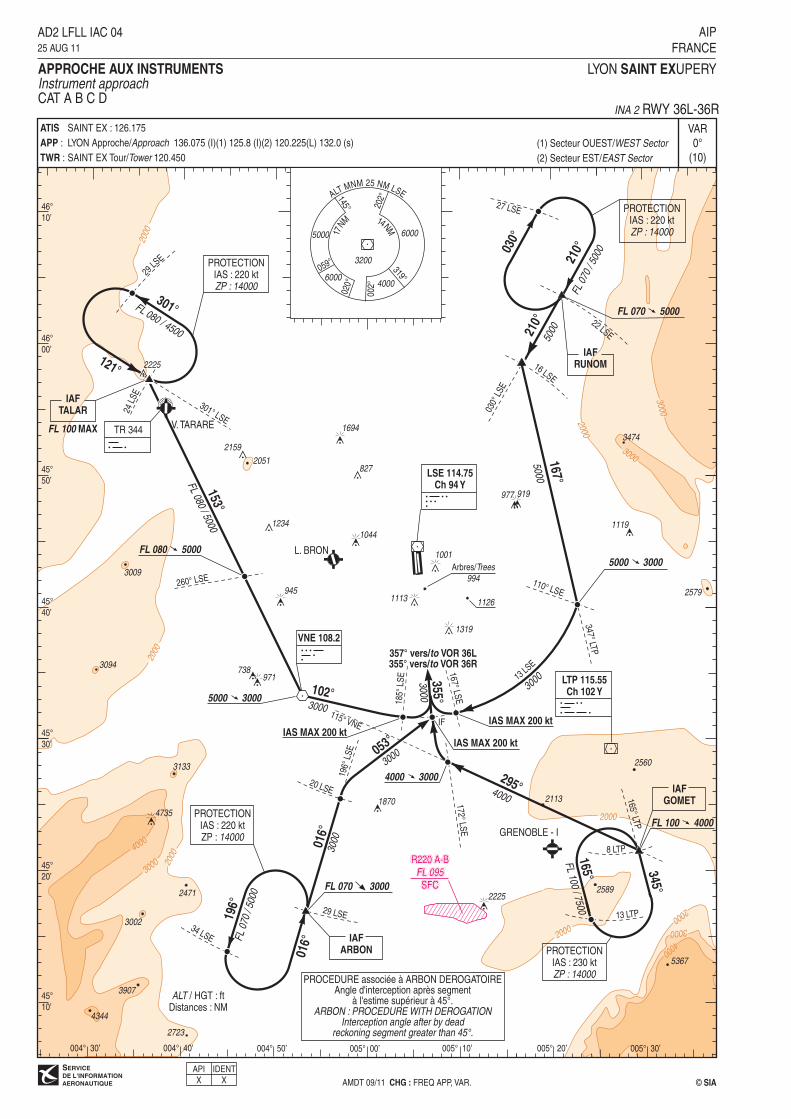
AD2 LFLL IAC 0425 AUG 11
AIP
FRANCE
APPROCHE AUX INSTRUMENTS
Instrument approachCAT A B C D
INA 2 RWY 36L-36RATIS SAINT EX : 126.175
APP : LYON Approche/Approach 136.075 (I)(1) 125.8 (I)(2) 120.225(L) 132.0 (s)
TWR : SAINT EX Tour/Tower 120.450
(1) Secteur OUEST/WEST Sector
(2) Secteur EST/EAST Sector
X X
17NM
14NM
202°145°
059° 3200
4000
5000
ALTMNM 25 NM LSE
020°
002°
319°6000
6000
IDENTAPI
1520(740)
1880(1100)
2060
(1280)
175°3000
(2220) 175°3.0°- 5.2%
MAPTLOC
FAFLOC
API : Monter dans l'axe. A 8.3 NM LSS tourner à droite
vers RM 226° pour intercepter et suivre le RDL 196° LSE
(RM 196°) en montée vers 5000 (4220). A ARBON, intégrerl'attente à 5000 (4220).Palier d'accélération non étudié.
Missed APCH : Climb straight ahead. At 8.3 NM LSSturn right to MAG 226° to intercept and followRDL 196° LSE (MAG 196°) climbing up to 5000 (4220).At ARBON, join holding at 5000 (4220).Acceleration level not studied.
MDA
LSS
DA
76.2
43.2
10.2
LSS (NM)LSE (NM)
IF
2000
2000
2000
2000
3000
3000
4000
3000
2000
2000
30004000
2000
3009
3094
3133
3002
3474
2589
4735
2819
1119
LSE 114.75
Ch 94 Y
LSS Ch 28 X
(109.1)L. BRON
V. TARARE
TR 344
LTP 115.55Ch 102 Y
GRENOBLE - I
2225
977919
1694
1044
945
971
3419
1234
827
1870
738
896
1126 (346)
1319 (539)
1113 (333)
VNE 108.2
1001 (221)
004°
LS
E346° LSE
IAS MAX 190 ktIAS MAX 190 kt
175°
3000
FAF
LOC 6.2 LSE7 LSS
4LSS
3.2 LSE
175°
196°
LS
E
175°
226°
196°
9 LSE
8.3 LSS
15 LSE
ARBON
226°1
96°
016°
29 LSE34 LSE
PROTECTIONIAS : 220 ktZP : 14000
IF
2051
2159
VOR et/and DME requis/required
R220 A-B
FL 095
SFC
LYON SAINT EXUPERY
VAR
0°
(10)
ILS - DME
LSS 109.1
RDH : 49
REF HGT : ALT THR
C A
T
A
B
C
D
DL
FAF - THR70 kt
5 min 4585 kt
4 min 44100 kt
4 min 01115 kt
3 min 30130 kt
3 min 06160 kt
2 min 31185 kt
2 min 10
VSP (ft/min)
ILS
6.7 NM
TA : 5000
ALT / HGT : ftDistances : NM
© SIAAMDT 09/11 CHG : FREQ APP, VAR, minima.
AD2 LFLL IAC 0525 AUG 11
AIP
FRANCE
APPROCHE AUX INSTRUMENTS
Instrument approachCAT A B C DALT AD : 821, THR : 780 (29 hPa) FNA ILS ou/or LOC RWY 18L
MNM AD : distances verticales en pieds, RVR et VIS en mètres./Vertical distances in feet, RVR and VIS in metres.
IDENTOCHAPIX X
370 450 525 605 685 845 975
004° 30'
45°
50'
45°
30'
45°
20'
004° 40' 004° 50' 005° 00' 005° 10' 005° 20' 005° 30'
6
2720(1940)
3
1740(960)
2
1420(640)
DME LSS
NM
ALT(HGT)
4
2060(1280)
5
2390(1610)
RVR MDA (H)
1120 (340)
RVR
MVL /CirclingLOC
OCH : 337
DA (H) MDA (H)
1300 (520)
1410 (630)
1580 (800)
1720 (940)
VIS
1500
1600
2400
3600
OCHILS
CAT 1
1500
145
155
168
183
186
980 (200) 1200
-- --
(1) (2)
Observations/Remarks : (1) Base OCH : NIL. (2) Circuit RWY 36 droite. /(1) OCH base : NIL. (2) Right hand circuit RWY 36.
45°
40'
004° 20'
ATIS
APP :
TWR :
SAINT EX 126.175
LYON Approche/Approach 136.075 (I)(1) 125.8 (I)(2) 120.225 (L) 132.0(s)
SAINT EX Tour/Tower 120.450
(1) Secteur OUEST/WEST Sector
(2) Secteur EST/EAST Sector
XVSS
API : Monter RM 169°. A LSE suivre le RDL 176° LSE (RM 176°).A 9 NM LSE tourner à droite vers RM 226° pour intercepter etsuivre le RDL 196° LSE (RM 196°) en montée vers 5000 (4242).A ARBON, intégrer l'attente à 5000 (4242).Palier d'accélération non étudié.
Missed APCH : Climb MAG 169°. At LSE follow RDL 176° LSE(MAG 176°). At 9 NM LSE turn right to MAG 226° to interceptand follow RDL 196° LSE (MAG 196°) climbing up to 5000 (4242).At ARBON, join holding at 5000 (4242).Acceleration level not studied.
6.9 3.7 1LSE (NM) 0
1880(1122)
1955
(1197)
169°
176°
3000
(2242)
MDA
APCH non dans l'axeAPCH out of RWY axis
169°5.2% MAPT
FAF
LSE
IF
1520(762)
2000
2000
2000
2000
3000
3000
4000
3000
2000
2000
30004000
2000
3009
3094
3133
3002
3474
2589
47352819
1119LSE 114.75
Ch 94 YL. BRON
V. TARARE
TR 344
LTP 115.55Ch 102 Y
GRENOBLE - I
2225
977919
1694
1044
945
971
3419
1234
827
1870
738
1126 (368)
1319 (561)
1113 (355)
VNE 108.2
1001 (243)
358° LSE
340° LSE
IAS MAX 200 ktIAS MAX 200 kt
169°
3000FAF
169°
196°
LS
E
176°
226°
196°
9 LSE
15 LSE
ARBON
226°1
96°
016°
29 LSE34 LSE
PROTECTIONIAS : 220 ktZP : 14000
IF
6.9 LSE
1 LSE
MAPT
Relief
896 (138)176° LS
E
ATTENTION
Risque de confusion entre piste etportion d�autoroute située sous l�axe
d�approche entre 3 et 1.5 NM enamont du THR 18R.
CAUTIONMix-up risk between RWY and
highway located under approach axisbetween 3 and 1.5 NM above THR 18R.
2051
2159
DME requis/required
R220 A-B
FL 095
SFC
LYON SAINT EXUPERY
VAR
0°
(10)
REF HGT : ALT THR
C A
T
A
B
C
D
FAF - THR70 kt
5 min 5585 kt
4 min 52100 kt
4 min 08115 kt
3 min 36130 kt
3 min 11160 kt
2 min 35185 kt
2 min 14
VSP (ft/min)
6.9 NM
TA : 5000
ALT / HGT : ftDistances : NM
© SIAAMDT 09/11 CHG : FREQ APP, VAR, minima.
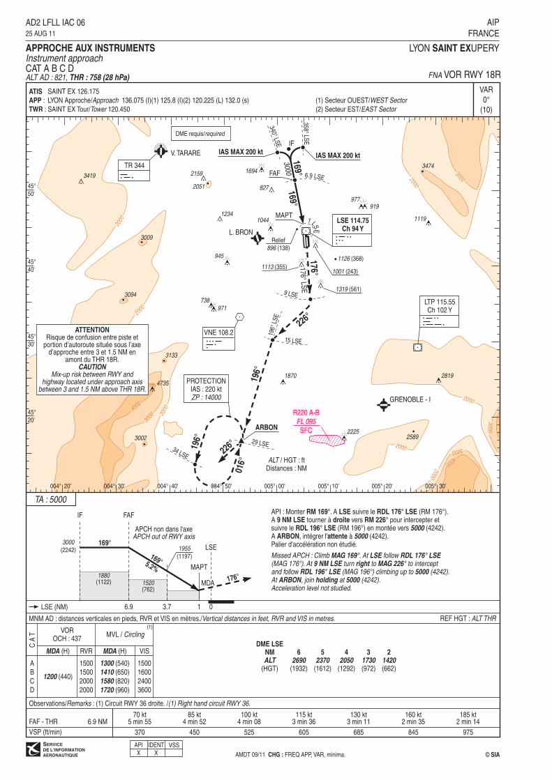
AD2 LFLL IAC 0625 AUG 11
AIP
FRANCE
APPROCHE AUX INSTRUMENTS
Instrument approachCAT A B C DALT AD : 821, THR : 758 (28 hPa) FNA VOR RWY 18R
MNM AD : distances verticales en pieds, RVR et VIS en mètres./Vertical distances in feet, RVR and VIS in metres.
IDENT
X
370 450 525 605 685 845 975
004° 30'
45°
50'
45°
30'
45°
20'
004° 40' 004° 50' 005° 00' 005° 10' 005° 20' 005° 30'
6
2690(1932)
3
1730(972)
2
1420(662)
DME LSE
NM
ALT(HGT)
4
2050(1292)
5
2370(1612)
RVR MDA (H) VIS
MVL / CirclingVOR
OCH : 437
MDA (H)
1300 (540)
1410 (650)
1580 (820)
1720 (960)
1500
1600
2400
3600
1200 (440)
(1)
Observations/Remarks : (1) Circuit RWY 36 droite. /(1) Right hand circuit RWY 36.
45°
40'
004° 20'
1500
1500
2000
2000
ATIS
APP :
TWR :
SAINT EX 126.175
LYON Approche/Approach 136.075 (I)(1) 125.8 (I)(2) 120.225 (L) 132.0 (s)
SAINT EX Tour/Tower 120.450
(1) Secteur OUEST/WEST Sector
(2) Secteur EST/EAST Sector
API
XVSS
API : Monter dans l'axe. A 1.8 NM LSE tourner à droite (IAS MAX 185 kt)vers RM 050° pour intercepter et suivre le RDL 020° LSE (RM 020°) enmontée vers 5000 (4187). A 27 NM LSE tourner à droite pour intégrerl'attente RUNOM à 5000 (4187).Palier d'accélération non étudié.
Missed APCH : Climb straight ahead. At 1.8 NM LSE turn right(IAS MAX 185 kt) to MAG 050° to intercept and follow RDL 020° LSE(MAG 020°) climbing up to 5000 (4187). At 27 NM LSE turn rightto join RUNOM holding at 5000 (4187).Acceleration level not studied.
355°
3.0°-
5.2%
DA
1390
(577)
2550
(1737)
355° 3000
(2187)
12.9
SAN
FAFLOC
2190
(1377)MAPTLOC
MDHMDA
0 1.83.7
4.36.2
5.47.3
6.98.8
0.2
OM
SAN (NM)LSE (NM)
IF
1360(547)
1490(677)
1630(817)
2350(1537)
200020
00
2000
2000
2000
2000
3000
V. TARARE
2225
LSE 114.75
Ch 94 Y
SAN Ch 44 Y
(110.75)
TR 344
27 LSE
030°
LSE
020°
LSE
030°
210°
FL 0
70 /
5000
PROTECTIONIAS : 220 ktZP : 14000
22 LSE
FL 070 5000
020°
LTP 115.55Ch 102 Y
1.8 LSE
050°
355°
IAS MAX 185 kt
L. BRON
VNE 108.2
IAS MAX 200 kt
053°
9 LSE6.9 SAN
FAF 8.8 LSE7.3 LSE
5.4SAN
OM
355°
355°
3000
GP utilisable uniquement pourACFT équipé ILS à 50 kHz.
GP usable only by ACFTwith ILS 50 kHz equipment.
3094
2051
3474
1126 (313)
Arbres/Trees
994 (181)
3000
1001 (188)
1319 (506)1113 (300) 2579
1119
3009
1694
971738
945
10441234
827
977
919
2159
IF
RUNOM
13 LSE
VOR et/and DME requis/required
6
2750(1937)
3
1770(957)
2
1450(637)
DME SAN
NM
ALT(HGT)
4
2100(1287)
5
2420(1607)
LYON SAINT EXUPERY
VAR
0°
(10)
ILS - DME
SAN 110.75
RDH : 59
REF HGT : ALT THR
C A
T
A
B
C
D
DL
FAF - THR70 kt
5 min 4585 kt
4 min 44100 kt
4 min 01115 kt
3 min 30130 kt
3 min 06160 kt
2 min 31185 kt
2 min 10
1020 (200)
RVR
550
MDA (H)
1250 (440)
RVR
VSP (ft/min)
ILS z MVL / CirclingLOC z
OCH : 437
DA (H)
6.7 NM
MDA (H)
1310 (490)
1420 (600)
1580 (760)
1720 (900)
VIS
1500
1600
2400
3600
TA : 5000
ALT / HGT : ftDistances : NM
© SIAAMDT 09/11 CHG : FREQ APP, VAR, minima.
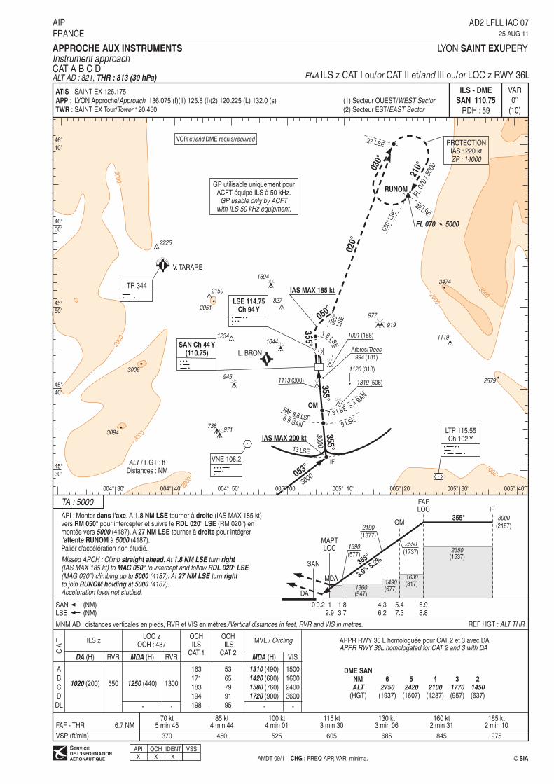
AD2 LFLL IAC 0725 AUG 11
AIP
FRANCE
APPROCHE AUX INSTRUMENTS
Instrument approachCAT A B C DALT AD : 821, THR : 813 (30 hPa) FNA ILS z CAT I ou/or CAT II et/and III ou/or LOC z RWY 36L
MNM AD : distances verticales en pieds, RVR et VIS en mètres./Vertical distances in feet, RVR and VIS in metres.
53
65
79
91
95
OCHILS
CAT 1
OCH ILS
CAT 2
370 450 525 605 685 845 975
1300
163
171
183
194
198
APPR RWY 36 L homologuée pour CAT 2 et 3 avec DAAPPR RWY 36L homologated for CAT 2 and 3 with DA
46°
10'
004° 30'
46°
00'
45°
50'
45°
40'
45°
30'
004° 40' 004° 50' 005° 00' 005° 10' 005° 20' 005° 30' 005° 40'
-- --
ATIS
APP :
TWR :
SAINT EX 126.175
LYON Approche/Approach 136.075 (I)(1) 125.8 (I)(2) 120.225 (L) 132.0 (s)
SAINT EX Tour/Tower 120.450
(1) Secteur OUEST/WEST Sector
(2) Secteur EST/EAST Sector
IDENTOCHAPIX X X
VSS
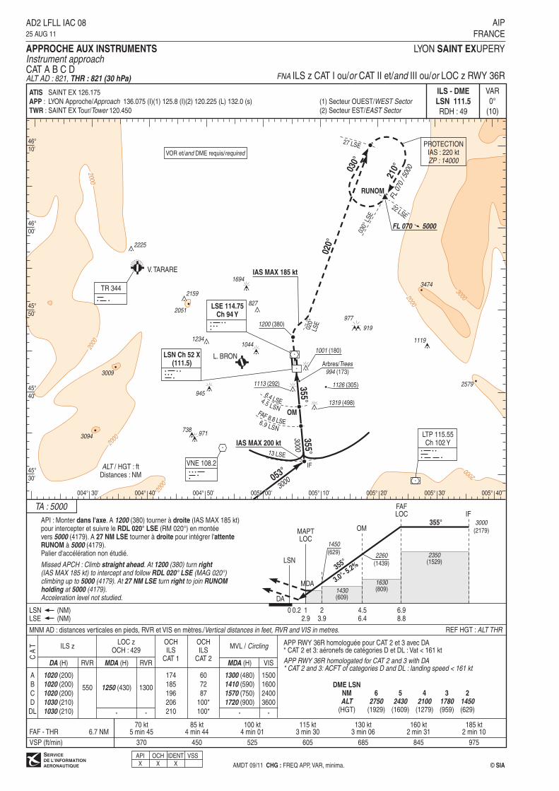
API : Monter dans l'axe. A 1200 (380) tourner à droite (IAS MAX 185 kt)pour intercepter et suivre le RDL 020° LSE (RM 020°) en montéevers 5000 (4179). A 27 NM LSE tourner à droite pour intégrer l'attente
RUNOM à 5000 (4179).Palier d'accélération non étudié.
Missed APCH : Climb straight ahead. At 1200 (380) turn right(IAS MAX 185 kt) to intercept and follow RDL 020° LSE (MAG 020°)climbing up to 5000 (4179). At 27 NM LSE turn right to join RUNOMholding at 5000 (4179).Acceleration level not studied.
355°
3.0°-
5.2%
DA
1450
(629)
355° 3000
(2179)
12.9
LSN
FAFLOC
2260
(1439)
MAPTLOC
MDHMDA
0 23.9
4.56.4
6.98.8
0.2
OM
LSN (NM)LSE (NM)
IF
1430(609)
1630(809)
2350(1529)
2000
2000
2000
2000
2000
2000
3000
6.9 LSN
V. TARARE
2225
TR 344
27 LSE
030°
LSE
030°
210°
FL 0
70 /
5000
PROTECTIONIAS : 220 ktZP : 14000
22 LSE
FL 070 5000
020°
LTP 115.55Ch 102 Y
IAS MAX 185 kt
L. BRON
VNE 108.2
IAS MAX 200 kt
053°
355°
355°
3000
3094
2051
3474
3000
1113 (292) 2579
1119
3009
1694
971738
945
10441234
827
977
919
2159
IF
RUNOM
LSE 114.75
Ch 94 Y
LSN Ch 52 X
(111.5)
FAF 8.8 LSE
OM
4.5 LSN
6.4 LSE
1126 (305)
Arbres/Trees
994 (173)
1001 (180)
1319 (498)
020°
LSE1200 (380)
VOR et/and DME requis/required
LYON SAINT EXUPERY
VAR
0°
(10)
ILS - DME
LSN 111.5
RDH : 49
REF HGT : ALT THR
C A
T
A
B
C
D
DL
FAF - THR70 kt
5 min 4585 kt
4 min 44100 kt
4 min 01115 kt
3 min 30130 kt
3 min 06160 kt
2 min 31185 kt
2 min 10
VSP (ft/min)
ILS z
6.7 NM
TA : 5000
ALT / HGT : ftDistances : NM
© SIA
AD2 LFLL IAC 0825 AUG 11
AIP
FRANCE
APPROCHE AUX INSTRUMENTS
Instrument approachCAT A B C DALT AD : 821, THR : 821 (30 hPa) FNA ILS z CAT I ou/or CAT II et/and III ou/or LOC z RWY 36R
MNM AD : distances verticales en pieds, RVR et VIS en mètres./Vertical distances in feet, RVR and VIS in metres.
370 450 525 605 685 845 975
46°
10'
004° 30'
46°
00'
45°
50'
45°
40'
45°
30'
004° 40' 004° 50' 005° 00' 005° 10' 005° 20' 005° 30' 005° 40'
13 LSE
6
2750(1929)
3
1780(959)
2
1450(629)
DME LSN
NM
ALT(HGT)
4
2100(1279)
5
2430(1609)
RVR MDA (H)
1250 (430)
RVR
MVL / CirclingLOC z
OCH : 429
DA (H) MDA (H)
1300 (480)
1410 (590)
1570 (750)
1720 (900)
VIS
1500
1600
2400
3600
OCHILS
CAT 2
1300
60
72
87
100*
100*
1020 (200)
1020 (200)
1020 (200)
1030 (210)
1030 (210)
550
-- --
ATIS
APP :
TWR :
SAINT EX 126.175
LYON Approche/Approach 136.075 (I)(1) 125.8 (I)(2) 120.225 (L) 132.0 (s)
SAINT EX Tour/Tower 120.450
(1) Secteur OUEST/WEST Sector
(2) Secteur EST/EAST Sector
OCHILS
CAT 1
174
185
196
206
210
AMDT 09/11 CHG : FREQ APP, VAR, minima.
APP RWY 36R homologuée pour CAT 2 et 3 avec DA* CAT 2 et 3: aéronefs de catégories D et DL : Vat < 161 kt
APP RWY 36R homologated for CAT 2 and 3 with DA* CAT 2 and 3: ACFT of categories D and DL : landing speed < 161 kt
IDENTX X
VSSOCHAPIX
2000
2000
2000
2000
2000
3000
3000
4000
3000
4000
2000
FL 100 4000
V. TARARE
TR 344
L. BRON
GRENOBLE - I
LTP 115.55
Ch 102 Y
VNE 108.2
LSE 114.75
Ch 94 Y
SAN Ch 44 Y
(110.75)
GP utilisable uniquement pourACFT équipé ILS à 50 kHz.
GP usable only by ACFTwith ILS 50 kHz equipment.
IAF
GOMET
345°
165°
FL 100 / 7500
8 LTP
13 LTP
2589
IAS MAX 200 kt
295°4000
115° VNE
OM
355°
FAF
LOC PROTECTIONIAS : 230 ktZP : 14000
5.4 SAN
10 SAN
020°
IAS MAX 185 kt
050°
1.8LS
E
1126 (313)
1001 (188)
1319 (506)
1044
1694
827
1113 (300)
945
971738
977
919
1119
2819
2225
1870
4735
1234
3474
896
2051
3009
3133
3002
3094
2159
IF
VOR et/and DME requis/required
R220 A-B
FL 095
SFC
API : Monter dans l'axe. A 1.8 NM LSE tourner à droite (IAS MAX 185 kt)vers RM 050° pour intercepter et suivre le RDL 020° LSE (RM 020°) en montéevers 5000 (4187). A 27 NM LSE tourner à droite pour intégrer l'attente
RUNOM à 5000 (4187).Palier d'accélération non étudié.
Missed APCH : Climb straight ahead. At 1.8 NM LSE turn right(IAS MAX 185 kt) to MAG 050° to intercept and follow RDL 020° LSE(MAG 020°) climbing up to 5000 (4187). At 27 NM LSE turn rightto join RUNOM holding at 5000 (4187).Acceleration level not studied.
355°
3.0°-
5.2%
DA
1390
(577)
2550
(1737)
355° 4000
(3187)
12.9
SAN
FAFLOC
2190
(1377)MAPTLOC
1.83.7
4.36.2
5.47.3
1011.9
OM
SAN (NM)LSE (NM)
IF
1360 (547)1490(677)
2140(1327)
2430(1617)
MDA
LYON SAINT EXUPERY
VAR
0°
(10)
ILS - DME
SAN 110.75
RDH : 59
REF HGT : ALT THR
C A
T
A
B
C
D
DL
FAF - THR70 kt
8 min 2485 kt
6 min 55100 kt
5 min 52115 kt
5 min 06130 kt
4 min 31160 kt
3 min 40185 kt
3 min 10
1020 (200)
RVR
550
MDA (H)
1250 (440)
RVR
VSP (ft/min)
ILS y MVL / CirclingLOC y
OCH : 437
DA (H)
9.8 NM
MDA (H)
1310 (490)
1420 (600)
1580 (760)
1720 (900)
VIS
1500
1600
2400
3600
TA : 5000
ALT / HGT : ftDistances : NM
© SIAAMDT 09/11 CHG : FREQ APP, VAR, minima.
AD2 LFLL IAC 0925 AUG 11
AIP
FRANCE
APPROCHE AUX INSTRUMENTS
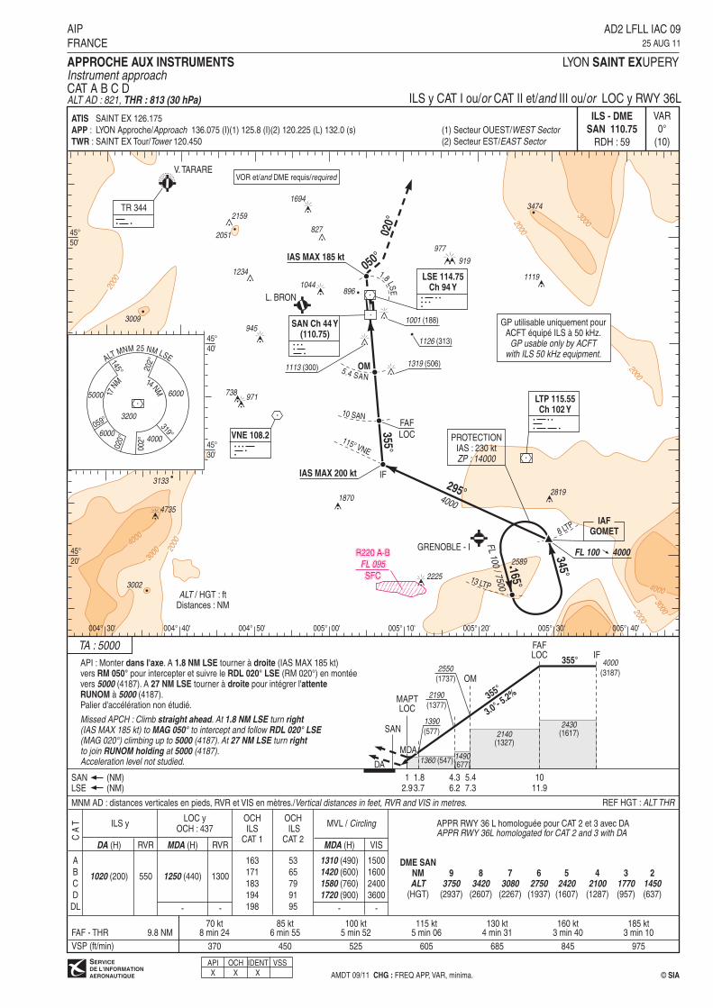
Instrument approachCAT A B C DALT AD : 821, THR : 813 (30 hPa) ILS y CAT I ou/or CAT II et/and III ou/or LOC y RWY 36L
MNM AD : distances verticales en pieds, RVR et VIS en mètres./Vertical distances in feet, RVR and VIS in metres.
53
65
79
91
95
OCHILS
CAT 1
OCH ILS
CAT 2
370 450 525 605 685 845 975
1300
163
171
183
194
198
APPR RWY 36 L homologuée pour CAT 2 et 3 avec DAAPPR RWY 36L homologated for CAT 2 and 3 with DA
17NM
14 NM
202°145°
059° 3200
4000
5000
ALTMNM 25 NM LSE
020°
002°
319°6000
6000
45°
50'
004° 30'
45°
40'
45°
20'
45°
30'
004° 40' 004° 50' 005° 00' 005° 10' 005° 20' 005° 30' 005° 40'
-- --
ATIS
APP :
TWR :
SAINT EX 126.175
LYON Approche/Approach 136.075 (I)(1) 125.8 (I)(2) 120.225 (L) 132.0 (s)
SAINT EX Tour/Tower 120.450
(1) Secteur OUEST/WEST Sector
(2) Secteur EST/EAST Sector
IDENTX X
VSSOCHAPIX
6
2750(1937)
3
1770(957)
2
1450(637)
DME SAN
NM
ALT(HGT)
4
2100(1287)
5
2420(1607)
7
3080(2267)
8
3420(2607)
9
3750(2937)
API : Monter dans l'axe. A 1200 (379) tourner à droite (IAS MAX 185 kt)pour intercepter et suivre le RDL 020° LSE (RM 020°) en montéevers 5000 (4179). A 27 NM LSE tourner à droite pour intégrer l'attente
RUNOM à 5000 (4179).Palier d'accélération non étudié.
Missed APCH : Climb straight ahead. At 1200 (379) turn right(IAS MAX 185 kt) to intercept and follow RDL 020° LSE (MAG 020°)climbing up to 5000 (4179). At 27 NM LSE turn right to join RUNOMholding at 5000 (4179).Acceleration level not studied.
355°
3.0°-
5.2%
DA
1450
(629)
355° 4000
(3179)
12.9
LSN
FAFLOC
2260
(1439)
MAPTLOC
23.9
4.56.4
1011.9
OM
LSN (NM)LSE (NM)
IF
1430(609)
2140(1319)
2430(1609)
MDA
2000
2000
2000
2000
2000
3000
3000
4000
3000
4000
2000
FL 100 4000
V. TARARE
TR 344
L. BRON
GRENOBLE - I
LTP 115.55
Ch 102 Y
VNE 108.2
LSE 114.75
Ch 94 Y
IAF
GOMET
345°
165°
FL 100 / 7500
8 LTP
13 LTP
2589
IAS MAX 200 kt
295°4000
115° VNE
OM
355°
FAF
LOC PROTECTIONIAS : 230 ktZP : 14000
020°
IAS MAX 185 kt
1126 (305)
1001 (180)
1319 (498)
1044
1694
827
1113 (292)
945
971738
977
919
1119
2819
2225
1870
4735
1234
3474
896
2051
3009
3133
3002
3094
2159
LSN Ch 52 X
(111.5)
10 LSN
4.5 LSN
IF
VOR et/and DME requis/required
R220 A-B
FL 095
SFC
LYON SAINT EXUPERY
VAR
0°
(10)
ILS - DME
LSN 111.5
RDH : 49
REF HGT : ALT THR
C A
T
A
B
C
D
DL
FAF - THR70 kt
8 min 2485 kt
6 min 55100 kt
5 min 52115 kt
5 min 06130 kt
4 min 31160 kt
3 min 40185 kt
3 min 10
VSP (ft/min)
ILS y
9.8 NM
TA : 5000
ALT / HGT : ftDistances : NM
© SIA
AD2 LFLL IAC 1025 AUG 11
AIP
FRANCE
APPROCHE AUX INSTRUMENTS
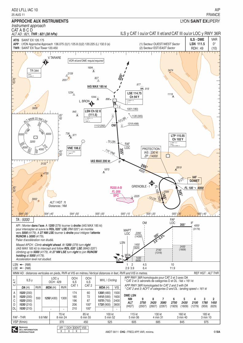
Instrument approachCAT A B C DALT AD : 821, THR : 821 (30 hPa) ILS y CAT I ou/or CAT II et/and CAT III ou/or LOC y RWY 36R
MNM AD : distances verticales en pieds, RVR et VIS en mètres./Vertical distances in feet, RVR and VIS in metres.
370 450 525 605 685 845 975
17NM
14NM
202°145°
059° 3200
4000
5000
ALTMNM 25 NM LSE
020°
002°
319°6000
6000
45°
50'
004° 30'
45°
40'
45°
20'
45°
30'
004° 40' 004° 50' 005° 00' 005° 10' 005° 20' 005° 30' 005° 40'
RVR MDA (H)
1250 (430)
RVR
MVL / CirclingLOC y
OCH : 429
DA (H) MDA (H)
1300 (480)
1410 (590)
1570 (750)
1720 (900)
VIS
1500
1600
2400
3600
OCHILS
CAT 2
1300
60
72
87
100*
100*
1020 (200)
1020 (200)
1020 (200)
1030 (210)
1030 (210)
550
-- --
ATIS
APP :
TWR :
SAINT EX 126.175
LYON Approche/Approach 136.075 (I)(1) 125.8 (I)(2) 120.225 (L) 132.0 (s)
SAINT EX Tour/Tower 120.450
(1) Secteur OUEST/WEST Sector
(2) Secteur EST/EAST Sector
AMDT 09/11 CHG : FREQ APP, VAR, minima.
APP RWY 36R homologuée pour CAT 2 et 3 avec DA* CAT 2 et 3: aéronefs de catégories D et DL : Vat < 161 kt
APP RWY 36R homologated for CAT 2 and 3 with DA* CAT 2 and 3: ACFT of categories D and DL : landing speed < 161 kt
IDENTX X
VSS
OCHILS
CAT 1
174
185
196
206
210
OCHAPIX
6
2750(1929)
3
1780(959)
2
1450(629)
DME LSN
NM
ALT(HGT)
4
2100(1279)
5
2430(1609)
7
3080(2267)
8
3420(2607)
9
3750(2937)

API : Monter suivant le RDL 357° LSE (RM 357°). A 1.8 NM LSE tourner à droite
(IAS MAX 185 kt) vers RM 050° pour intercepter et suivre le RDL 020° LSE (RM 020°)en montée vers 5000 (4179). A 27 NM LSE tourner à droite pour intégrer l'attente
RUNOM à 5000 (4179).Palier d'accélération non étudié.
Missed APCH : Climb RDL 357° LSE (MAG 357°). At 1.8 NM LSE turn right(IAS MAX 185 kt) to MAG 050° to intercept and follow RDL 020° LSE(MAG 020°) climbing up to 5000 (4179). At 27 NM LSE turn right to joinRUNOM holding at 5000 (4179).Acceleration level not studied.
357°
5.2%
1370
(549)
357° 3000
(2179)
2.1
FAF
2170
(1349)
MAPT
MDHMDA
3.7 6.2 8.8LSE (NM)
IF
1360(539)
1630(809)
2430(1609)
APCH non dans l�axe
APCH out of RWY axis
357°
200020
00
2000
2000
2000
2000
3000
V. TARARE
2225
LSE 114.75
Ch 94 Y
TR 344
27 LSE
030°
LSE
020°
LSE
030°
210°
FL 0
70 /
5000
PROTECTIONIAS : 220 ktZP : 14000
22 LSE
FL 070 5000
020°
LTP 115.55Ch 102 Y
1.8 LSE
050°
357°
IAS MAX 185 kt
L. BRON
VNE 108.2
IAS MAX 200 kt
053°
FAF 8.8 LSE
357°
357°
3000
3094
2051
3474
1126 (305)
Arbres/Trees
994 (173)
3000
1001 (180)
1319 (498)
1113 (292) 2579
1119
3009
1694
971738
945
10441234
827
977
919
2159
IF
357°
3000
RUNOM
172° LSE
295°
6.2 LSE
3.7 LSE
355°
4000 3000
DME requis/required
LYON SAINT EXUPERY
VAR
0°
(10)
REF HGT : ALT AD
FAF - THR70 kt
5 min 4585 kt
4 min 44100 kt
4 min 01115 kt
3 min 30130 kt
3 min 06160 kt
2 min 31185 kt
2 min 10
VSP (ft/min)
6.7 NM
TA : 5000
ALT / HGT : ftDistances : NM
© SIAAMDT 09/11 CHG : FREQ APP, VAR, minima.
AD2 LFLL IAC 1125 AUG 11
AIP
FRANCE
APPROCHE AUX INSTRUMENTS
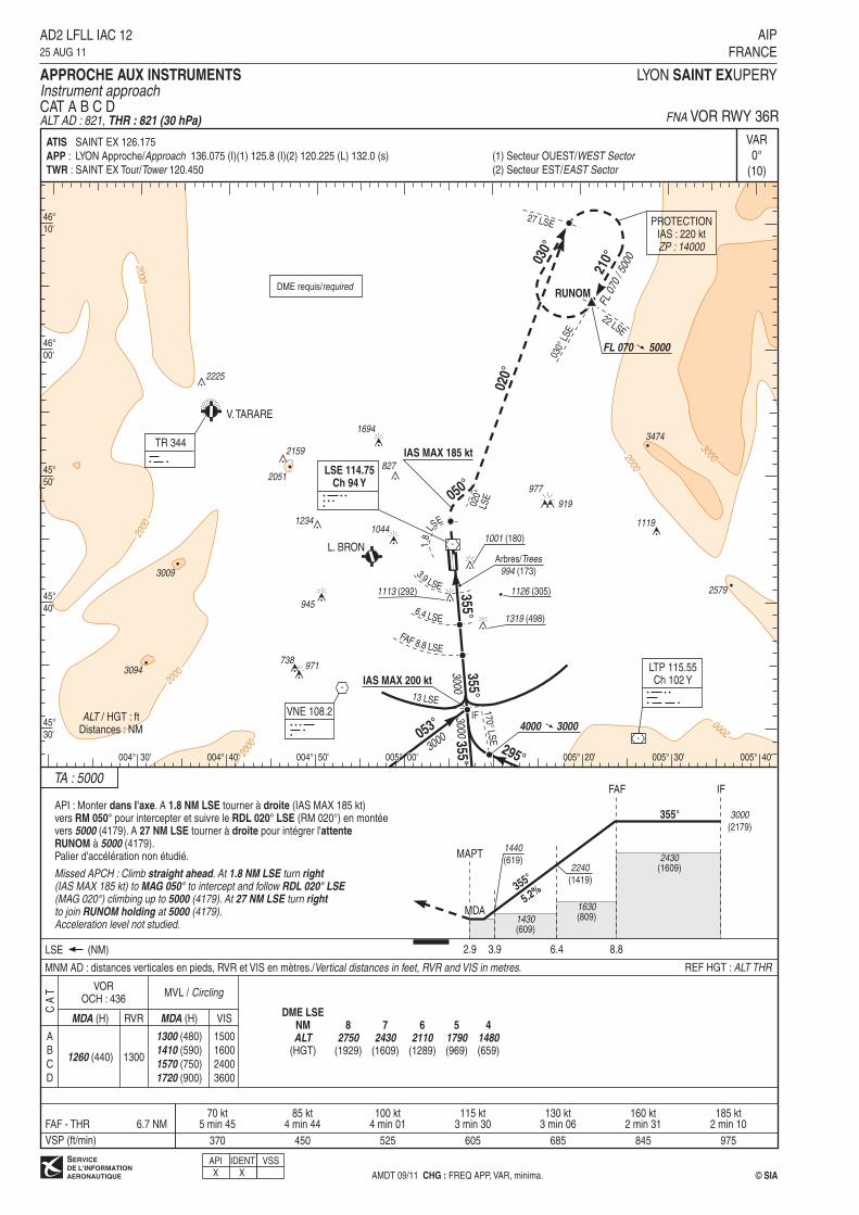
Instrument approachCAT A B C DALT AD : 821 (30 hPa), THR : 813 FNA VOR RWY 36L
MNM AD : distances verticales en pieds, RVR et VIS en mètres./Vertical distances in feet, RVR and VIS in metres.
IDENT
X
370 450 525 605 685 845 975
46°
10'
004° 30'
46°
00'
45°
50'
45°
40'
45°
30'
004° 40' 004° 50' 005° 00' 005° 20' 005° 30' 005° 40'
13 LSE
8
2740(1919)
5
1790(969)
4
1470(649)
DME LSE
NM
ALT(HGT)
6
2100(1279)
7
2420(1599)
C A
T
A
B
C
D
1260 (440)
RVR MDA (H) VIS
MVL / Circling
MDA (H)
1300 (480)
1410 (590)
1570 (750)
1720 (900)
1500
1600
2400
3600
VOROCH : 436
1300
ATIS
APP :
TWR :
SAINT EX 126.175
LYON Approche/Approach 136.075 (I)(1) 125.8 (I)(2) 120.225 (L) 132.0 (s)
SAINT EX Tour/Tower 120.450
(1) Secteur OUEST/WEST Sector
(2) Secteur EST/EAST Sector
API
XVSS
355°
5.2%
1440
(619)
355° 3000
(2179)
2.9
FAF
2240
(1419)
MAPT
MDHMDA
3.9 6.4 8.8LSE (NM)
IF
1430(609)
1630(809)
API : Monter dans l'axe. A 1.8 NM LSE tourner à droite (IAS MAX 185 kt)vers RM 050° pour intercepter et suivre le RDL 020° LSE (RM 020°) en montéevers 5000 (4179). A 27 NM LSE tourner à droite pour intégrer l'attente
RUNOM à 5000 (4179).Palier d'accélération non étudié.
Missed APCH : Climb straight ahead. At 1.8 NM LSE turn right(IAS MAX 185 kt) to MAG 050° to intercept and follow RDL 020° LSE(MAG 020°) climbing up to 5000 (4179). At 27 NM LSE turn rightto join RUNOM holding at 5000 (4179).Acceleration level not studied.
2430(1609)
2000
2000
2000
2000
2000
2000
3000
V. TARARE
2225
TR 344
27 LSE
030°
LSE
030°
210°
FL 0
70 /
5000
PROTECTIONIAS : 220 ktZP : 14000
22 LSE
FL 070 5000
020°
LTP 115.55Ch 102 Y
IAS MAX 185 kt
L. BRON
VNE 108.2
IAS MAX 200 kt
053°
355°
355°
3000
3094
2051
3474
3000
1113 (292) 2579
1119
3009
1694
971738
945
10441234
827
977
919
2159
IF
355°
3000
RUNOM
LSE 114.75
Ch 94 Y
FAF 8.8 LSE
6.4 LSE
1126 (305)
Arbres/Trees
994 (173)
1001 (180)
1319 (498)
020°
LSE
1.8
LSE
3.9 LSE
295°
4000 3000
050°
DME requis/required
LYON SAINT EXUPERY
VAR
0°
(10)
REF HGT : ALT THR
FAF - THR70 kt
5 min 4585 kt
4 min 44100 kt
4 min 01115 kt
3 min 30130 kt
3 min 06160 kt
2 min 31185 kt
2 min 10
VSP (ft/min)
6.7 NM
TA : 5000
ALT / HGT : ftDistances : NM
© SIAAMDT 09/11 CHG : FREQ APP, VAR, minima.
AD2 LFLL IAC 1225 AUG 11
AIP
FRANCE
APPROCHE AUX INSTRUMENTS
Instrument approachCAT A B C DALT AD : 821, THR : 821 (30 hPa) FNA VOR RWY 36R
MNM AD : distances verticales en pieds, RVR et VIS en mètres./Vertical distances in feet, RVR and VIS in metres.
IDENTX
370 450 525 605 685 845 975
46°
10'
004° 30'
46°
00'
45°
50'
45°
40'
45°
30'
004° 40' 004° 50' 005° 00' 005° 20' 005° 30' 005° 40'
13 LSE
8
2750(1929)
5
1790(969)
4
1480(659)
DME LSE
NM
ALT(HGT)
6
2110(1289)
7
2430(1609)
C A
T
A
B
C
D
1260 (440)
RVR MDA (H) VIS
MVL / Circling
MDA (H)
1300 (480)
1410 (590)
1570 (750)
1720 (900)
1500
1600
2400
3600
VOROCH : 436
1300
170° LSE
ATIS
APP :
TWR :
SAINT EX 126.175
LYON Approche/Approach 136.075 (I)(1) 125.8 (I)(2) 120.225 (L) 132.0 (s)
SAINT EX Tour/Tower 120.450
(1) Secteur OUEST/WEST Sector
(2) Secteur EST/EAST Sector
APIX
VSS