ad 2.lfst ad 2 lfst sum ad 2 lfst text 1 ad 2...
TRANSCRIPT
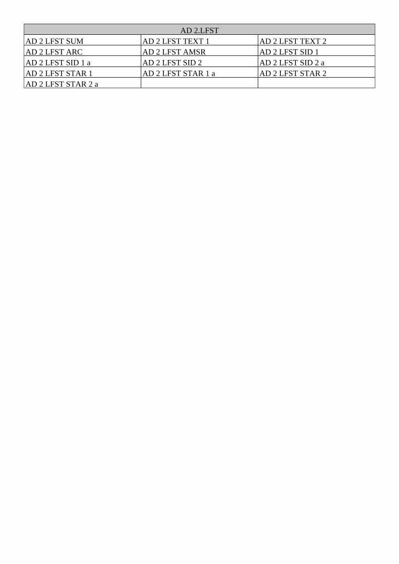
AD 2.LFSTAD 2 LFST SUM AD 2 LFST TEXT 1 AD 2 LFST TEXT 2AD 2 LFST ARC AD 2 LFST AMSR AD 2 LFST SID 1AD 2 LFST SID 1 a AD 2 LFST SID 2 AD 2 LFST SID 2 aAD 2 LFST STAR 1 AD 2 LFST STAR 1 a AD 2 LFST STAR 2AD 2 LFST STAR 2 a
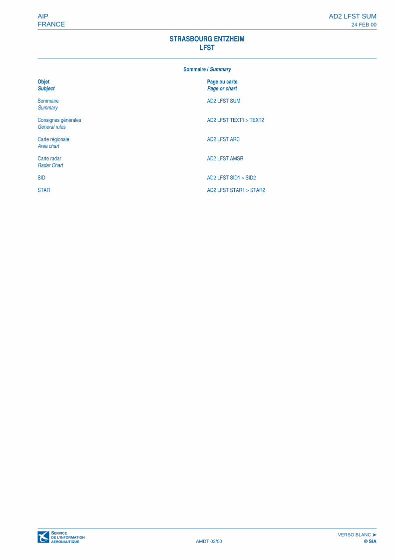
Sommaire / Summary
Objet Page ou carteSubject Page or chart
Sommaire AD2 LFST SUMSummary
Consignes générales AD2 LFST TEXT1 > TEXT2General rules
Carte régionale AD2 LFST ARCArea chart
Carte radar AD2 LFST AMSRRadar Chart
SID AD2 LFST SID1 > SID2
STAR AD2 LFST STAR1 > STAR2
AIP AD2 LFST SUMFRANCE 24 FEB 00
VERSO BLANC ➤AMDT 02/00 © SIA
STRASBOURG ENTZHEIMLFST
AMDT 01/07 © SIA
STRASBOURG ENTZHEIM
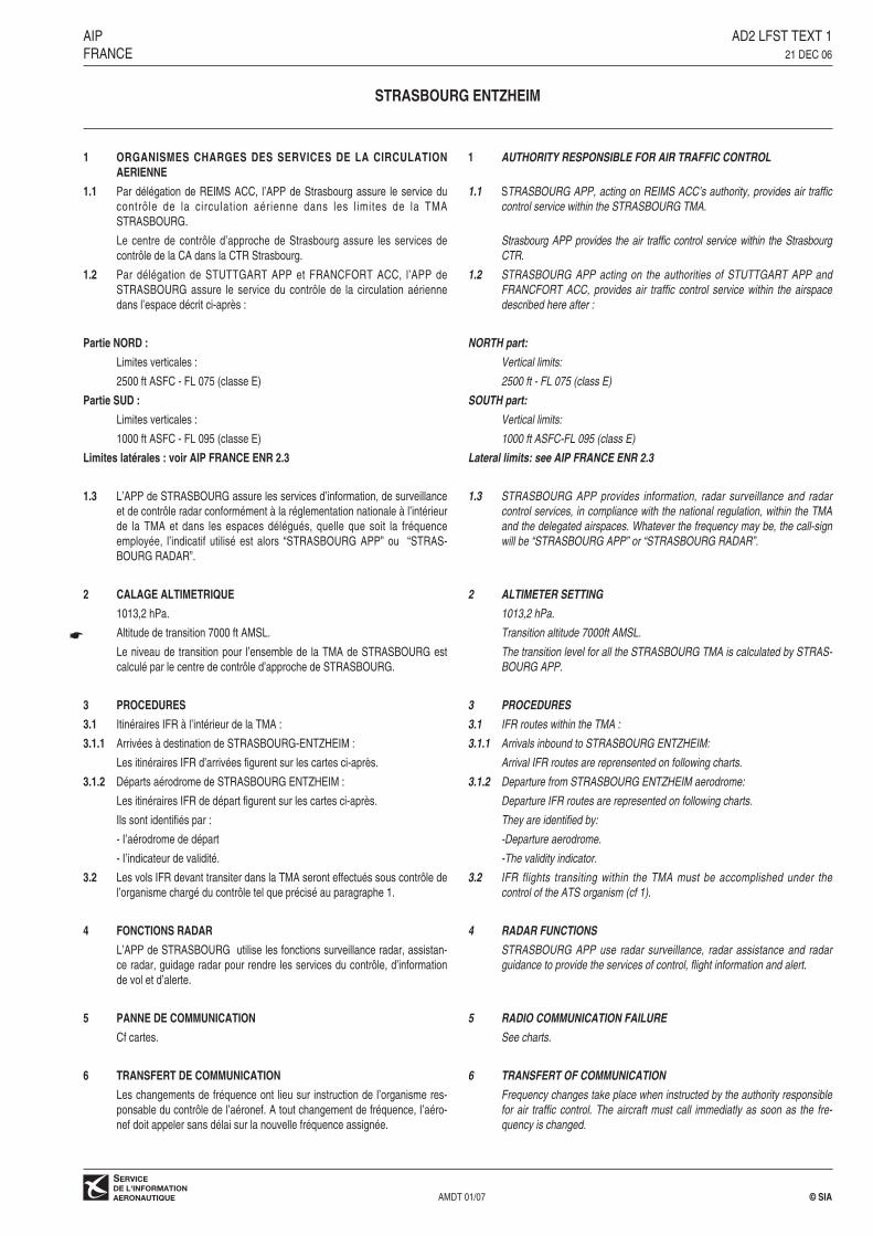
1 ORGANISMES CHARGES DES SERVICES DE LA CIRCULATIONAERIENNE
1.1 Par délégation de REIMS ACC, l’APP de Strasbourg assure le service ducontrôle de la circulation aérienne dans les l imites de la TMA STRASBOURG.
Le centre de contrôle d’approche de Strasbourg assure les services decontrôle de la CA dans la CTR Strasbourg.
1.2 Par délégation de STUTTGART APP et FRANCFORT ACC, l’APP deSTRASBOURG assure le service du contrôle de la circulation aériennedans l’espace décrit ci-après :
Partie NORD :
Limites verticales :
2500 ft ASFC - FL 075 (classe E)
Partie SUD :
Limites verticales :
1000 ft ASFC - FL 095 (classe E)
Limites latérales : voir AIP FRANCE ENR 2.3
1.3 L’APP de STRASBOURG assure les services d’information, de surveillanceet de contrôle radar conformément à la réglementation nationale à l’intérieurde la TMA et dans les espaces délégués, quelle que soit la fréquenceemployée, l’indicatif utilisé est alors “STRASBOURG APP” ou “STRAS-BOURG RADAR”.
2 CALAGE ALTIMETRIQUE
1013,2 hPa.
Altitude de transition 7000 ft AMSL.
Le niveau de transition pour l’ensemble de la TMA de STRASBOURG estcalculé par le centre de contrôle d’approche de STRASBOURG.
3 PROCEDURES
3.1 Itinéraires IFR à l’intérieur de la TMA :
3.1.1 Arrivées à destination de STRASBOURG-ENTZHEIM :
Les itinéraires IFR d’arrivées figurent sur les cartes ci-après.
3.1.2 Départs aérodrome de STRASBOURG ENTZHEIM :
Les itinéraires IFR de départ figurent sur les cartes ci-après.
Ils sont identifiés par :
- I’aérodrome de départ
- I’indicateur de validité.
3.2 Les vols IFR devant transiter dans la TMA seront effectués sous contrôle del’organisme chargé du contrôle tel que précisé au paragraphe 1.
4 FONCTIONS RADAR
L’APP de STRASBOURG utilise les fonctions surveillance radar, assistan-ce radar, guidage radar pour rendre les services du contrôle, d’informationde vol et d’alerte.
5 PANNE DE COMMUNICATION
Cf cartes.
6 TRANSFERT DE COMMUNICATION
Les changements de fréquence ont lieu sur instruction de l’organisme res-ponsable du contrôle de l’aéronef. A tout changement de fréquence, I’aéro-nef doit appeler sans délai sur la nouvelle fréquence assignée.
1 AUTHORITY RESPONSIBLE FOR AIR TRAFFIC CONTROL
1.1 STRASBOURG APP, acting on REIMS ACC’s authority, provides air trafficcontrol service within the STRASBOURG TMA.
Strasbourg APP provides the air traffic control service within the StrasbourgCTR.
1.2 STRASBOURG APP acting on the authorities of STUTTGART APP andFRANCFORT ACC, provides air traffic control service within the airspacedescribed here after :
NORTH part:
Vertical limits:
2500 ft - FL 075 (class E)
SOUTH part:
Vertical limits:
1000 ft ASFC-FL 095 (class E)
Lateral limits: see AIP FRANCE ENR 2.3
1.3 STRASBOURG APP provides information, radar surveillance and radarcontrol services, in compliance with the national regulation, within the TMAand the delegated airspaces. Whatever the frequency may be, the call-signwill be “STRASBOURG APP” or “STRASBOURG RADAR”.
2 ALTIMETER SETTING
1013,2 hPa.
Transition altitude 7000ft AMSL.
The transition level for all the STRASBOURG TMA is calculated by STRAS-BOURG APP.
3 PROCEDURES
3.1 IFR routes within the TMA :
3.1.1 Arrivals inbound to STRASBOURG ENTZHEIM:
Arrival IFR routes are reprensented on following charts.
3.1.2 Departure from STRASBOURG ENTZHEIM aerodrome:
Departure IFR routes are represented on following charts.
They are identified by:
-Departure aerodrome.
-The validity indicator.
3.2 IFR flights transiting within the TMA must be accomplished under thecontrol of the ATS organism (cf 1).
4 RADAR FUNCTIONS
STRASBOURG APP use radar surveillance, radar assistance and radarguidance to provide the services of control, flight information and alert.
5 RADIO COMMUNICATION FAILURE
See charts.
6 TRANSFERT OF COMMUNICATION
Frequency changes take place when instructed by the authority responsiblefor air traffic control. The aircraft must call immediatly as soon as the fre-quency is changed.
AIP AD2 LFST TEXT 1FRANCE 21 DEC 06
☛
AMDT 01/07 © SIA
STRASBOURG ENTZHEIM
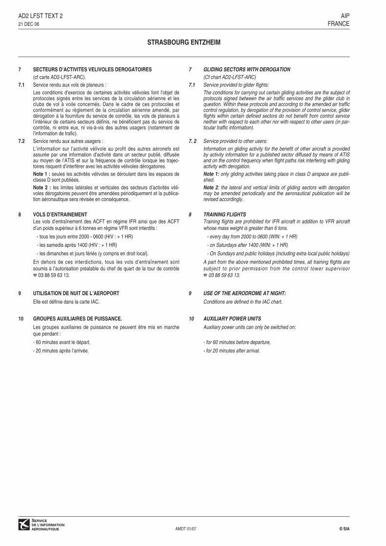
7 SECTEURS D’ACTIVITES VELIVOLES DEROGATOIRES(cf carte AD2-LFST-ARC).
7.1 Service rendu aux vols de planeurs : Les conditions d’exercice de certaines activités vélivoles font l’objet deprotocoles signés entre les services de la circulation aérienne et lesclubs de vol à voile concernés. Dans le cadre de ces protocoles etconformément au règlement de la circulation aérienne amendé, pardérogation à la fourniture du service de contrôle, les vols de planeurs àl’intérieur de certains secteurs définis, ne bénéficient pas du service decontrôle, ni entre eux, ni vis-à-vis des autres usagers (notamment del’information de trafic).
7.2 Service rendu aux autres usagers : L’information sur l’activité vélivole au profit des autres aéronefs estassurée par une information d’activité dans un secteur publié, diffuséeau moyen de l’ATIS et sur la fréquence de contrôle lorsque les trajec-toires risquent d’interférer avec les activités vélivoles dérogatoires.Note 1 : seules les activités vélivoles se déroulant dans les espaces declasse D sont publiées.Note 2 : les limites latérales et verticales des secteurs d’activités véli-voles dérogatoires peuvent être amendées périodiquement et la publica-tion aéronautique sera révisée en conséquence.
8 VOLS D’ENTRAINEMENTLes vols d’entraînement des ACFT en régime IFR ainsi que des ACFTd’un poids supérieur à 6 tonnes en régime VFR sont interdits :
- tous les jours entre 2000 - 0600 (HIV : + 1 HR)
- les samedis après 1400 (HIV : + 1 HR)
- les dimanches et jours fériés (y compris en droit local).
En dehors de ces interdictions, tous les vols d’entraînement sont soumis à l’autorisation préalable du chef de quart de la tour de contrôle ☎ 03 88 59 63 13.
9 UTILISATION DE NUIT DE L’AEROPORT
Elle est définie dans la carte IAC.
10 GROUPES AUXILIAIRES DE PUISSANCE.
Les groupes auxiliaires de puissance ne peuvent être mis en marcheque pendant :
- 60 minutes avant le départ,
- 20 minutes après l’arrivée.
7 GLlDlNG SECTORS WITH DEROGATION(Cf chart AD2-LFST-ARC)
7.1 Service provided to glider flights: The conditions for carrying out certain gliding activities are the subject ofprotocols signed between the air traffic services and the glider club inquestion. Within these protocols and according to the amended air trafficcontrol regulation, by derogation of the provision of control service, gliderflights within certain defined sectors do not benefit from control serviceneither with respect to each other nor with respect to other users (in par-ticular traffic information).
7. 2 Service provided to other users:Information on gliding activity for the benefit of other aircraft is providedby activity information for a published sector diffused by means of ATISand on the control frequency when flight paths risk interfering with glidingactivity with derogation.Note 1: only gliding activities taking place in class D airspace are publi-shed.Note 2: the lateral and vertical limits of gliding sectors with derogationmay be amended periodically and the aeronautical publication will berevised accordingly.
8 TRAINING FLIGHTSTraining flights are prohibited for IFR aircraft in addition to VFR aircraftwhose mass weight is greater than 6 tons.
- every day from 2000 to 0600 (WIN: + 1 HR)
- on Saturdays after 1400 (WIN: + 1 HR)
- On Sundays and public holidays (including extra local public holidays)
A part from the above mentioned prohibited times, all training flights aresubject to prior permission from the control tower supervisor ☎ 03 88 59 63 13.
9 USE OF THE AERODROME AT NIGHT:
Conditions are defined in the IAC chart.
10 AUXILIARY POWER UNITS
Auxiliary power units can only be switched on:
- for 60 minutes before departure,
- for 20 minutes after arrival.
AD2 LFST TEXT 2 AIP21 DEC 06 FRANCE
����
����
����
����
����
����
��������
����
����
��������� ���
�����������������������
����������������������
������������
�� ���������
����� ���
!"��#�����������������������
�
�
�
�
�
�
�
�
� ��
�
�
�
�
�
�
��
��
�
�
�
�
������������
�����
���
���������
������
������ ���������
�����
�� ��
� ���
�� ���
� ���
� ���
� ���� ����
�� ����
���
������
� ����
� ����
� ����
���
�����
�����
���
� ����
� �
� ����
������
�����
�� ����
� ���
�
���
�� ���� ��
���
�
��
���
�
������
��
���
��
����
���
�� �
����
��
�
��
�
����
�
�
����
�
� �
����
���� � ��� ����
�
����
�
���
����
����
������
������
������������������
��
�
� �
����
������ ��
�� �
�� �
��������
����
�
������
����
����$�
������
����
���
���
����
���������������
����������� �
��������������
��������������
�����������
���
���
������%&!
������%&!
����
������%&!
������%&!
�
����������
�������� ��� �!��� �
�������'�
������"�
����
��������
��� �
���������������
����������� �
�������$�
� �����"�
�����������
�
�����������
��������������
����$
�������
��
�����
��������
�
���������������� ����������
���������������� ����������
��������������������� ���������������������� �
��������������
��������������
��������������������������
���� ��������
���� ������
���� �������
#����
���� �$�%�
()�
�� �� �%� �
���� ���"
�������� &'()*+,
���� ���
���
�����
�%���
����
�$'�
��'
��� $�
#������
� ���
������
��� ���)����-
��$��� �)����.
�%���� ��
������� �)���.
��� �
�����)�� �-/ ��0
������
��#��
#����
�*�
�%��
����
����)���./���� 0
������
���
�� ����
������ ��� �!��� �
�� ���%��
�% ��
����%
#%��
���%-
������� �
��# �
�� �
�����
#����������� �
����
����
�����"����� ������
+%��$����� �
�%#"���
������/� 0
������������������� ��!"#$%�&
����������/0��*1'*23��2*4'�5���,"�,�-"��!�/�0��*1'*23� 4'�5�(�,"�,�-"�
/�0��*�6*4'+7&&8+3*�*4'�8&&7&19�423���%���'384:7236+��.�������#,������-�����%+/!�!"��, ���
��� %��� �7&'3;<*50�"�1 "39=2*&1*4�>*4�4*1'*234�5�!�-"�����2���-#�,��%� �������� ����� �## �������� �??371)*5%33��- �����/0�!���� �/�0�!��� � �/40�@ �������� �7235+4�� �����
�������5��������'��398'+7&��A����A�������*'��A����� �A� ���*'� ����7<,83�
/�0 ��8<'+'2>*�>*�'38&4+'+7&�82�>*4424�>2�'*33+'7+3*��<<*,8&>�*4'�>*�������"�+��"���,#"#���1"#"����� 5��6��.���"���#"�7�#,�������"8
B����
�*1'*23�C9<+C7<*�>93768'7+3*61#�#���,�-"��4#"������"#�
%�+�5�����D�E'
����������
������
�������������
������%&!
������%&!
�
��������
��� �
������������
�������������
������������
�������������
�������
����
������������
� � ���%��
������##��
�������
����
�
���������
����
�
������������/�0 ����������� �
�������������
������������/�0
������������� �
���� �������
��
����������� �
���� ������
�*1'*23��� ��
�*1'*23� ��
����� ��
��������
�����
���� �
����������
����
����
����
����
����
����
����
����
����
������
��������� ���������
������
�� ���
���
�� ���
�
���� ����
����
����
����
����
��������
����
����
����
����
���
���
����
����
���
����
���������������������
��������������������� ����������
��������������������������������
���������������������
���������������������
���������������������
���������������������
���������������������
���������������������
���������������������
���������������������
���������������������
���������������������
��������������������� ����������
�����������
���������������������
���������������������
���������������������
���������������������
���������������������
���������������������
���������������������
�������������������������������
��������������������������������
���������������������
���������������������
���������������������
���������������������
���������������������
���������������������
���������������������
���������������������
���������������������
���������������������
���������������������
���������������������
���������������������
���������������������
���������������������
���������������������
���������������������
���������������������
���������������������
���������������������
���������������������
���������������������
���������������������
���������������������
�� ��
�� ��
� ��
�� ��
�� ��
�� ��
������������������������������������������
����
�����������
��� �
!"����#�$�
�""�!���$��
%������&
���"�
��!�����
��"
�$�'��
��� ���"!
����
���
��
���
��
�$�����"�!
��!�
����
���
�""����"!
�""����$��
�$��(�
���$�
��$)�
��)$*
'%�����
����
�"��
��� �
�+)��
)��
�
�"
�"
"�
��
!�#
������ ������
����
����
����
���
���� ���
����
��
���
�����
���
��������
��
����
"���"
���
�"����"!�,�-./0
����
����!
���
�+�"��
���
���� &����"�����"���
�� ����
�$�&"��'�
+�"����1��2
������������� �����������������������������������
�� ���������������������������
1�2��� ��� 3��4����� ���������1�2��� ���3��4����� ������
��$ �"����"!� ���%������ �"����"! �55�6�.4�������� ���%��1�2������%���1�2������%����132
7�����������4����� ���$ %
����� ���!��� 3���"�36,���89� 9:3�56 ��93�;8333��05:�8� �3% 3��"+��1�/,/0 0�"8<8��+��6�/,=��9�/� <32� �/9/38;93,��83�<� �=,��6 �56 �� ,�/,�:=�8�/6,�,�$&"�8 �<33 3< ����/�6/���9908,<�36,��93�>89 �3�5 ;9/:3�?�9��$���9908,<%
������������� ��� ���������� ��� �� ��!���������"��� ��#� $�%&%!�! ����� #�����%&' ���%�����( �%�� ��� ���)��%& ���� �� �!��'�&�* �� ��� �& +,� %&��'���%�& �)�-� .��!�&����%���* ��� ��� �&�� �%�� ��� ��)�%���� %& ��� .��!�& �+/"
�0� 4��!��@�A�
����
����
����
����
����
����
����
����
��������
������
��������� ���������
������
�� ������ ���
���
�������������
��������
������
������
����
������
��
������
�������
�����
�� �
����
����
��
����
��
�����
������
�������
����
���
��
��!�
����
��!�
������������
����
���
"�
�
�!�"
��
��
"�
�
� �"�
�
�������
���
"��
� �"
� �"��#
� �"
��#
��!�
��
������
���
"�
�
�� �"��
�������
������
��
����
�����
�������
��
$��������
�%$��
�������� �
$������" ��
&����%�'
%$����$�
�$%�
� �(%�
����
����
����
������
�����
%�����
�����!&�()�����*
�������&�!()����+
$,����
�����
$,����&�!()����+
��#���!&�()���!�*
��$����
���
��#����&�!()����+
�%�����
���
�$����%��$#��-�$#��
$������ ��
# ��.�
��# �
�� ��
(&%����
��������"
���
����
��
����
����
����
����
��������
���
����
����
����
���
����
��
�%$������
#����
��$������/�0)12
# ���
������&�
����������������� ���
�� ����
� ������
,$�����3�!4
�� ����� �������������� ����������� �������� �� ����������������
� !"�#$#%�&"'!�(����)�)()�*
������%���/�5�
���������������������������
$� ��$������ ���&��!$�� ��$����� $66�7�) ���&��3�� ��7 8�9���� ������4�-����&�!�3�� ��8�9���� ������4�-����&!�!�384�:� ��$����� �7 � ���&��!
��; �7�18;�17/�6;��1� <1=��>�<�$������ ��� ���������
�+%�!,-�."/%�?�8� #�>@��1�8�67 ��<8�;@�7>�728�>��$%�����$����%�9�$#��-�$#��87/��@�;A<18�67 �� /��7/51B �;�17/�/��'��<1@�;C���'�&
����������� !�����"�! #�� ��� #���!� �# ��$% ��! &�%��%'$�()� �*+)� �*��� ����"�����! #�� � ���#�,-������ .��� /0' �����!�! .��� �0��1�2
�����������
AIP AD2 LFST SID 1aFRANCE 28 SEP 06
AMDT 10/06 © SIA
STRASBOURG ENTZHEIMSID RWY 05 - SID RWY 03 KARLSRUHE BADEN ET LAHR
(Protégées pour CAT A, B, C, D)
CONSIGNES GENERALES
Les aéronefs doivent se conformer aux spécifications fixées pour chaque itinérairenormalisé de départ. Les itinéraires sont définis pour les ACFT dont les perfor-mances de montée permettent d'adopter la pente minimale de 5 % (Pente ATS).Dans le cas contraire les CDT de bord sont tenus de le signaler dès la demande demise en route.
DEPARTS OMNIDIRECTIONNELS
Utilisables uniquement sur clairance de l'APP.
Monter dans l'axe à 1500 ft (995) (1) puis route directe en montée jusqu’à l’altitudede sécurité en route.
(1) La tour d’altitude 4377 ft dans le 080° de l’ARP à 23 NM impose une pente théo-rique de montée de 4.1 % jusqu’à l’altitude de sécurité en route.
PANNE DE COM
- Afficher code 7600.
- En VMC : faire demi tour pour atterrir sur l'aérodrome.
- En IMC : poursuivre le vol jusqu'aux limites de la TMA, en respectant la trajectoire dedépart, au dernier FL assigné ou, si celui-ci n'est pas compatible avec les obstacles,au premier FL de sécurité et ensuite appliquer les éléments du PLN en vigueur.
ITINERAIRESGTQ 7J : monter dans l'axe. A SE, tourner à gauche RM 235° pour intercepter leQDR 274° SE (RM 274°). A DOBEG, intercepter le QDR 311° STR (RM 311°) versPHALO, GTQ ensuite (pente théorique : voir Note 1).BERUG 7J : monter dans l'axe. A SE, tourner à gauche RM 235° pour intercepter etsuivre le QDR 274° SE (RM 274°) vers BERUG (Pente théorique : voir Note 1).EPIKO 7J : monter dans l'axe. A SE, tourner à gauche RM 235° pour intercepter etsuivre le QDR 274° SE (RM 274°). A DIBOT, tourner à gauche pour suivre le RDL222° SAV (RM 222°) vers EPIKO (pente théorique : voir Note 1).LUPEN 7J : monter dans l'axe. A SE, tourner à gauche RM 235°. A l’interception duRDL 342° STR, tourner à gauche pour suivre le RDL 304° STR (RM 124°) versLUPEN (pente théorique : voir Note 3).GTQ 7K : monter dans l’axe. A SE, tourner à gauche pour intercepter et suivre leQDR 302° SE (RM 302°) vers GTQ (pente théorique : voir Note 2).SUL 1N : monter dans l’axe. A 20 NM STR, tourner à droite RM 130° pour intercepteret suivre le RDL 310° SUL. Sauf clairance du CTL, procéder SUL direct. (Pente théo-rique : voir Note 6 et 7).
KARLSRUHE-BADENSTR 1N : monter RM 032°. A 8 NM KBD, 3000 (2596) MNM, tourner à gauche pourintercepter et suivre le QDR 035° SE (RM 215°) vers SE, puis STR (pente théorique :voir Note 4).
LAHRSTR 1Q : monter RM 029°. A 6 NM LRD, tourner à gauche pour intercepter et suivrele RDL 088° STR (RM 268°) vers STR (pente théorique : voir Note 5).
Note 1 : Le franchissement des secteurs vélivoles dérogatoires Donon et Dabo, lors-qu’actifs, avec une marge verticale de 500 ft, nécessite le maintien d’une pente ATSde 6.5 % jusqu’à 7000 ft.Note 2 : le franchissement des secteurs vélivoles dérogatoires Donon et Dabo, lors-qu’actifs, avec une marge verticale de 500 ft, nécessite le maintien d’une pente ATSde 7 % jusqu’à 7000 ft.Note 3 : Le franchissement du secteur vélivole dérogatoire Neuhof, lorsqu’actif, avecune marge verticale de 500 ft, nécessite le maintien d’une pente ATS de 3.8 %jusqu’à 5000 ft.Note 4 : Le franchissement du secteur vélivole dérogatoire Haguenau, lorsqu’actif,avec une marge verticale de 500 ft, nécessite le maintien d’une pente ATS de 9.6 %jusqu’à 7000 ft.Note 5 : Le franchissement du secteur vélivole dérogatoire Neuhof, lorsqu’actif, avecune marge verticale de 500 ft, nécessite le maintien d’une pente ATS de 7.7 %jusqu’à 5000 ft.Note 6 : Cause réception VOR SUL à 8000 MNM, pente ATS 7.3 %.Note 7 : En cas d’activité vélicole à Haguenau, pente ATS 8.4 %. En cas d’impossibi-lité, en informer le contrôle.
GENERAL INSTRUCTIONS
ACFT are to comply with specifications stated for each SID. Routings are defined forACFT with climbing performances allowing to conduct a flight with a minimum slopegradient of 5 % (ATS Slope). If unable to do so the pilot must notify the TWR whenfirst contacting.
MULTIDIRECTIONAL DEPARTURES
Usable only with APP clearance.
Climb in the axis up to 1500 ft (995) (1) then proceed direct in climb up to en routesafety altitude.
(1) Tower altitude 4377 ft at 23 NM QDR 080° of the ARP impose a theoretical gra-dient of 4.1 % up to en route safety altitude.
RADIOCOMMUNICATION FAILURE
- Squawk code 7600 .
- In VMC, make a half-turn to land on the AD.
- In IMC, keep on flying until the TMA limits complying with the outgoing tracks at thelast FL assigned or if this one is not compatible with obstructions, at the last safe FLthen follow as stipulated in the current flight plan in force.
ROUTESGTQ 7J: climb runway heading. At SE turn left MAG track 235° to intercept and fol-low QDR 274° SE (MAG track 274°). At DOBEG, intercept QDR 311°STR (MAGtrack 311°) inbound PHALO, GTQ next (specified gradient: see Note 1).BERUG 7J: climb runway heading. At SE, turn left MAG track 235° to intercept and fol-low QDR 274° SE (MAG track 274°) inbound BERUG (specified gradient: see Note 1).EPIKO 7J: climb runway heading. At SE, turn left MAG track 235° to intercept andfollow QDR 274° SE (MAG track 274°). At DIBOT, turn left to follow RDL 222° SAV(MAG track 222°) inbound EPIKO (specified gradient: see Note 1).LUPEN 7J: climb runway heading. At SE, turn left MAG track 235°. At the intercep-tion of RDL 342° STR turn left to follow RDL 304° STR (MAG track 124°) inboundLUPEN (specified gradient: see Note 3).GTQ 7K: climb runway heading. At SE turn left to intercept and follow QDR 302° SE(MAG track 302°) inbound GTQ (specified gradient: see Note 2).SUL 1N: climb runway heading. At 20 NM STR, turn right MAG Track 130° to inter-cept and follow RDL 310° SUL. Except instruction from ATC, proceed direct to SUL.(Specified gradient : see Note 6 and 7).
KARLSRUHE-BADENSTR 1 N: climb MAG track 032°. At 8 NM KBD, 3000 ft (2596) MNM, turn left to inter-cept and follow QDR 035° SE (MAG track 215°) inbound SE, STR next (specifiedgradient: see Note 4).
LAHRSTR 1Q: climb MAG track 029°. At 6 NM LRD, turn left to intercept and follow RDL 088°STR (MAG track 268°) inbound STR (specified gradient: see Note 5).
Note 1: the clearing of derogatory gliding sectors Donon and Dabo when active witha vertical margin of 500 ft require to maintain an ATS climb gradient of 6.5 % up to7000 ft.Note 2: the clearing of derogatory gliding sectors Donon and Dabo when active witha vertical margin of 500 ft require to maintain an ATS climb gradient of 7 % up to7000 ft.Note 3: the clearing of derogatory gliding sector Neuhof when active with a verticalmargin of 500 ft require to maintain an ATS climb gradient of 3.8 % up to 5000 ft.
Note 4: the clearing of derogatory gliding sector Haguenau when active with a verti-cal margin of 500 ft require to maintain an ATS climb gradient of 9.6 % up to 7000 ft.
Note 5: the clearing of derogatory gliding sector Neuhof when active with a verticalmargin of 500 ft require to maintain an ATS climb gradient of 7.7 % up to 5000 ft.
Note 6: to receive VOR SUL at 8000 MNM, ATS climb gradient 7.3 %.Note 7: in case of glider activity at Haguenau, climb gradient 8.4%. If it isn’t possible,inform ATC.
☛
����
����
����
����
����
����
����
����
����
������
��������� ���������
������
��
���
���
��
���
�
��������
���
��
�����
��������
���
�����
��������
������
������
� ��
� �� ��
��
� ��
�� ! ��
����
�
��
����
��
����
��
����
���������
����
�� ����
�
����
��
����
������������
��������
�!��
����
����
����
���� �!
������������
����
�
����
����
��
�!�
���
����!���������
���
��
��"
#$"
%���$����
��%��
����������
%����������
�%����%�
�%��
$��&��
����
����
����
������
�����
������
�����! �&'�����(
������� �!&'����)
%*����
$����
%*���� �!&'����)
#$"���! �&'���!�(
#$%����
���
��"���� �!&'����)
�������
���
#%������$%"��+$%"��
%���������
"���,�
��"��
& �����
�����
���
����
��
����
����
����
����
����
����
���
����
����
���
����
��
��%�$����
"�$����%$����
�-�.'/0
��
�����
�����
�$���
������1
����
$%#�(������ �
������������������� �
�� ����
��������
*%�����2�!3
� ����������� ����������������������������������������������������
!"#�$%$&�'#("�)� ��*�*)*�+
����������-�4�
���������� � ����������������������������� ��!
%�� ��%$����� ��� ��!%�� ��%$���� %55�6�' ��� ��2�� ��6 7�8���� ������3�+���� �!�2�� ��7�8���� ������3�+���� !�!�273�9� ��%$���� �6 � ��� ��!
��/-7�� ��/6-�:�;�%������ ��� ���������
�,&�"-.�/#0&�<�7��"�:=��/�7�56 ��;7�>=�6:�607�:��%�����#%������8$%"��+$%"��76-��=�>?;/7�56 �� -��6-4/@ �>�/6-�-��1��;/=�>A���1�
����������� !�����"�! #�� ��� #���!� �# ��$% ��! &�%��%'$�()� �*+)� �*��� ����"�����! #�� � ���#�,-������ .��� /0' �����!�! .��� �0��1�2

AIP AD2 LFST SID 2aFRANCE 28 SEP 06
AMDT 10/06 © SIA
STRASBOURG ENTZHEIMSID RWY 23 - SID RWY 21 KARLSRUHE BADEN ET LAHR
(Protégées pour CAT A, B, C, D)
CONSIGNES GENERALES
Les aéronefs doivent se conformer aux spécifications fixées pour chaque itinéraire nor-malisé de départ. Les itinéraires sont définis pour les ACFT dont les performances demontée permettent d'adopter la pente minimale de 5 % (Pente ATS). Dans le cascontraire les CDT de bord sont tenus de le signaler dès la demande de mise en route.
DEPARTS OMNIDIRECTIONNELS
Utilisables uniquement sur clairance de l'APP.
Monter dans l'axe à 1500 ft (997) (1) puis route directe en montée jusqu’à l’altitudede sécurité en route.
(1) Le relief d’altitude 2799 ft dans le 232° de l’ARP à 11 NM impose une pente théo-rique de montée de 4.9 % jusqu’à l’altitude de sécurité en route.
PANNE DE COM- Afficher code 7600.- En VMC : faire demi tour pour atterrir sur l'aérodrome.- En IMC : poursuivre le vol jusqu'aux limites de la TMA, en respectant la trajectoire de
départ, au dernier FL assigné ou, si celui-ci n'est pas compatible avec les obstacles,au premier FL de sécurité et ensuite appliquer les éléments du PLN en vigueur.
ITINERAIRESGTQ 7H : monter dans l'axe. A STR, tourner à droite pour intercepter et suivre le RDL286° STR (RM 286°). A BERUG, tourner à droite pour suivre le RDL 159° GTQ (RM339°) vers GTQ (pente théorique : voir Note 1 et 4).POGOL 7H : monter dans l'axe. A STR, tourner à droite pour intercepter et suivre leRDL 260° STR (RM 260°) vers POGOL (pente théorique : voir Note 2 et 4).MIRGU 7H : monter dans l'axe. A STR, tourner à droite pour intercepter et suivre leRDL 260° STR (RM 260°). A OBORN, tourner à gauche pour suivre le RDL 038° LUL(RM 218°) (pente théorique : voir Note 2 et 4).LUPEN 7H : monter dans l'axe. A 3 NM STR, tourner à gauche RM 079° pour intercep-ter et suivre le RDL 124° STR (RM 124°) vers LUPEN (pente théorique : voir Note 5).GTQ 7L : monter dans l’axe. A STR, tourner à droite pour intercepter et suivre leRDL 311° STR (RM 311°) vers GTQ (pente théorique : voir Note 4)MIRGU 7L : monter dans l’axe jusqu’à STR puis RDL 231 ° STR (RM 231°) versMIRGU (pente théorique : voir Note 3).SUL 1S : monter dans l’axe. A 3 NM STR, tourner à gauche RM 079° vers LUPENen montée pour intercepter et suivre le RDL 275° SUL (RM 095°) à 8000. Sauf clai-rance du CTL, procéder SUL direct. (Pente théorique : voir Note 6 et 8).
KARLSRUHE-BADENSTR 1P : monter RM 214° vers LUPEN pour intercepter et suivre le RDL 124° STR(RM 304°) vers STR (pente théorique : voir Note 6).
LAHRSTR 1R : monter RM 209°. A 6 NM LRD, tourner à gauche pour intercepter et suivrele QDM 174° LHR (RM 354°). A LHR, suivre le QDR 329° LHR (RM 329°) versLUPEN (pente théorique : voir Note 7).
Note 1 : le relief d'altitude 3412 ft dans le QDR 271° de l'ARP à 16 NM impose unepente théorique de montée de 4 % jusqu'à l'altitude de sécurité en route.Note 2 : La tour d’altitude sommitale 2681 ft dans le QDR 247° de l’ARP à 11 NMimpose une pente théorique de montée de 4.2 % jusqu’à l’altitude de sécurité en route.Note 3 : le relief d'altitude 2799 ft dans le QDR 232° de l'ARP à 11 NM impose unepente théorique de montée de 4,3 % jusqu'à l'altitude de sécurité en route.Note 4 : Le franchissement des secteurs vélivoles dérogatoires Donon et Dabo, lors-qu’actifs, avec une marge verticale de 500 ft, nécessite le maintien d’une pente ATSde 8.9 % jusqu’à 7000 ft.Note 5 : le franchissement du secteur vélivole dérogatoire Neuhof, lorsqu’actifs, avecune marge verticale de 500 ft, nécessite le maintien d’une pente ATS de 8,5 %jusqu’à 5000 ft.Note 6 : le franchissement du secteur vélivole dérogatoire Neuhof, lorsqu’actifs, avecune marge verticale de 500 ft, nécessite le maintien d’une pente ATS de 4,8 %jusqu’à 5000 ft.Note 7 : le franchissement du secteur vélivole dérogatoire Neuhof, lorsqu’actif, avecune marge verticale de 500 ft, nécessite le maintien d’une pente ATS de 5.4 %jusqu’à 5000 ft.Note 8 : Cause réception VOR SUL à 8000 MNM, pente ATS 9.1%.
GENERAL INSTRUCTIONS
ACFT are to comply with specifications stated for each SID. Routings are defined forACFT with climbing performances allowing to conduct a flight with a minimum slopegradient of 5 % (ATS Slope). If unable to do so the pilot must notify the TWR whenfirst contacting.
MULTIDIRECTIONAL DEPARTURES
Usable on with APP clearance.
Climb in the axis up to 1500 ft (997) (1) then proceed direct in climb up to en routesafety altitude.
(1) Relief altitude 2799 ft at 11 NM QDR 232° of the ARP impose a theoretical gra-dient of 4.9 % up to en route safety altitude.
RADIOCOMMUNICATION FAILURE- Squawk code 7600 .- In VMC, make a half-turn to land on the AD.- In IMC, keep on flying until the TMA limits complying with the outgoing tracks at the
last FL assigned or if this one is not compatible with obstructions, at the last safe FLthen follow as stipulated in the current flight plan in force.
ROUTESGTQ 7H: climb runway heading. At STR turn right to intercept and follow RDL 286°STR (MAG track 286°). At BERUG, turn right to follow RDL 159° GTQ (MAG track339°) inbound GTQ. (specified gradient: see Note 1 and 4).POGOL 7H: climb runway heading. At STR turn right to intercept and follow RDL260° STR (MAG track 260°) inbound POGOL. (specified gradient: see Note 2 and 4).MIRGU 7H: climb runway heading. At STR turn right to intercept and follow RDL 260°STR (MAG track 260°). At OBORN, turn left to follow RDL 038° LUL (MAG track218°) (specified gradient: see Note 2 and 4).LUPEN 7H: climb runway heading. At 3 NM STR turn left MAG track 079° to intercept and fol-low RDL 124° STR (MAG track 124°) inbound LUPEN (specified gradient: see Note 1 and 5).GTQ 7L: climb runway heading. At STR turn right to intercept and follow RDL 311°STR (MAG track 311°) inbound GTQ (specified gradient: see Note 4).MIRGU 7L: climb runway heading to STR then RDL 231° STR (MAG track 231°)inbound MIRGU. (specified gradient: see Note 3).SUL 1S : climb runway heading. At 3 NM STR, turn left MAG Track 079° to LUPENclimbing to intercept and follow RDL 275° SUL (MAG track 095°) at 8000. Except ins-truction from ATC, proceed direct to SUL. (Specified gradient : see Note 6 and 8).
KARLSRUHE-BADENSTR 1 P: climb MAG track 214° inbound LUPEN to intercept and follow RDL 124°STR (MAG track 304°) inbound STR (specified gradient: see Note 6).
LAHRSTR 1R: climb MAG track 209°. At 6 NM LRD, turn left to intercept and follow QDM174° LHR (MAG track 354°). At LHR, follow QDR 329° LHR (MAG track 329°)inbound LUPEN (specified gradient: see Note 7).
Note 1: relief of altitude 3412 ft at 16 NM QDR 271° of the ARP impose a theoreticalgradient of 4 % up to the en route safety altitude.Note 2: tower of altitude 2681 ft at the top, 11 NM QDR 247° of the ARP impose atheoretical gradient of 4.2 % up to the en route safety altitude.Note 3: relief of altitude 2799 ft at 11 NM QDR 232° of the ARP impose a theoreticalgradient of 4.3 % up to the en route safety altitude.Note 4: the clearing of derogatory gliding sectors Donon and Dabo when active witha vertical margin of 500 ft require to maintain an ATS climb gradient of 8.9 % up to7000 ft.Note 5: the clearing of derogatory gliding sector Neuhof when active with a verticalmargin of 500 ft require to maintain an ATS climb gradient of 8.5 % up to 5000 ft.
Note 6: the clearing of derogatory gliding sector Neuhof when active, with a verticalmargin of 500 ft require to maintain an ATS climb gradient of 4.8 % up to 5000 ft.
Note 7: the clearing of derogatory gliding sector Neuhof when active with a verticalmargin of 500 ft require to maintain an ATS climb gradient of 5.4 % up to 5000 ft.
Note 8: to receive VOR SUL at 8000 MNM, ATS climb gradient 9.1%.
☛

����
����
����
����
����
����
����
����
������
��������� ���������
������
��
���
���
��
���
�
������
� ����
�� �� ��
�� ����
�� ��
�� �� ���
��������
����������������
�� �� ���
��
�
���������������
��
�����
�����������
�
����
����
����
����
����
��
�������� �����
����
������
���
��
�� � ����
����
������������
����
������ �� ������
�������� �������������� ���!��"#�������#�������!�����
���$��� ���������������� ��%��������& �'�(%�����)�
����
��� ��%*�����+�,'-.
%���*����
��������(�
%�������(��
����/�0
/%����%�
*(�1/�
���
���
�����
/�����
������ �1'�����2
������� ��1'�����
%!����
%!���� ��1'�����
����
��
%������(��
#(��3�
��#(�
1 /����
�����
����
��
���
� ��
���
���
���
���
���
���
�/%�*����
���
%�#��
���
������� �
������� �
��
*%4(2
����
�(���
���� ����
�
*����
���
� ��
������������������ ���
�������
�� �����
!%�����5��6
����������� ���� �������������
����� �!"�#�$��%����&�&%&�'
������/���+�7�
��������������������������������
%�( ��%*����� ��� ���%�� ��%*���� %88�9�' ��� ��5�� ��9 :�$�����������6�"���� ���5�� ��:�$�����������6�"���� ����5:6�;� ��%*���� �9 � ��� ���
�("!�)*+�,"�-
����. ��-��+�<::9 :�< ��������=�(%��%2�����)�
��������
���� ���������������������� �!�����"�#
AMDT 10/06 © SIA
PANNE DE COM
- Afficher le code A7600.
- Appliquer la procédure décrite ci-dessous :
- En VMC, poursuivre le vol en conditions VMC pour atterrir sur l’aérodromeapproprié le plus proche, et signaler son heure d’arrivée par les moyens lesplus rapides à l’organisme ATS approprié.
- En IMC, se présenter sur l’IAF ANDLO au dernier niveau assigné pour lequel ily a eu un accusé de réception, s’il est utilisable, à défaut au niveau le plusélevé de l’attente.
- Attendre à ce niveau jusqu’à la plus tardive des heures suivantes :- HAP s’il en a accusé réception,- ETA,- heure d’arrivée dans l’attente + 8 minutes.
- Descendre à 5500 ft QNH dans le circuit d’attente puis suivre la procédured’approche pour la piste 05.
PANNE DE COM SUIVIE D’UNE API
Appliquer la procédure d’API décrite sur le volet IAC pour effectuer une nouvelleprocédure d’approche. Si cette seconde tentative échoue, appliquer la procédure dedégagement de la TMA suivante :
- Après une procédure RWY 05 dégager la TMA en suivant le départ BERUG 7Jen montée vers le FL 090 et rechercher les conditions VMC.
- Après une procédure RWY 23 dégager la TMA en suivant le départ POGOL7H en montée vers le FL 090 et rechercher les conditions VMC.
PANNE DE COM CAS PARTICULIER : LE PILOTE N’A PAS CONNAISSANCE DELA PISTE EN SERVICE
- Se présenter sur l’IAF SAV au dernier niveau assigné pour lequel il y a eu unaccusé de réception, s’il est utilisable, à défaut le niveau le plus élevé de l’attente.
- Attendre à ce niveau jusqu’à la plus tardive des heures suivantes :- HAP s’il en a accusé réception,- ETA,- heure d’arrivée dans l’attente + 8 minutes.
- Descendre à 7000 ft QNH dans le circuit d’attente puis suivre la procédured’approche pour la piste 23, éventuellement suivie d’une MVL si le vent déterminépar le pilote indique que le QFU 05 est en service.
RADIOCOMMUNICATION FAILURE
- Squawk code A7600.
- The procedure to adopt is described below :
- In VMC, continue to fly in VMC conditions and land at the nearest suitableaerodrome. Notify the appropriate ATS unit of the time of arrival using the mostexpeditious means available.
- In IMC, proceed to the IAF ANDLO at the last assigned level that has beenacknowledged if this level is available, otherwise at the highest level of the hol-ding pattern.
- Maintain this level until the latest of the following times :- EAT if it has been acknowledged,- ETA,- time of arrival in the holding pattern + 8 minutes.
- Descend 5500 ft QNH in the holding pattern then follow the approach procedu-re for RWY 05.
RADIOCOMMUNICATION FAILURE FOLLOWED BY A MISSED APPROACH
Comply with the missed approach procedure described on IAC to perform a newAPCH procedure. If the last fails, adhere to procedure for clearing the TMA :
- After a RWY 05 procedure, clear the TMA following the SID BERUG 7J clim-bing to FL 090 and seek VMC conditions.
- After a RWY 23 procedure, clear the TMA following the SID POGOL 7H clim-bing to FL 090 and seek VMC conditions.
RADIOCOMMUNICATION FAILURE SPECIAL CASE : THE PILOT DOES NOTKNOW THE RUNWAY IN USE
- Proceed to the IAF SAV at the last assigned level that was acknowledged if thislevel is available, otherwise, at the highest level of the holding pattern.
- Maintain this level until the latest of the following times :- EAT if it has been acknowledged,- ETA,- time of arrival in the holding pattern + 8 minutes.
- Descend 7000 ft QNH in the holding pattern then follow the approach procedure forRWY 23, possibly followed by visual circling if the wind determined by the pilot indi-cates that QFU 05 is in use.
AIP AD2 LFST STAR 1aFRANCE 28 SEP 06
STRASBOURG ENTZHEIMSTAR RWY 05
(Protégées pour CAT A, B, C, D)
����
����
����
����
����
����
����
����
������
��������� ���������������
���
���
�����
�����
� �
����
��� �
�� �� ��
��������
������
������
������
� �� �
� ��
��
���
��
����
��
�� �� ��
�
�����
�
�������
��� ������ ���� �������
�� � ����
�
��
����
������ �����
��
����
�������
�������
������
���
���
�����
�����
����
�� ���
��
���
��
��
����
��
����
������������ ���������
�
��������� �����
�����
����
����
����
�������� ���!"#�����!$"
���� !�#�������%&'!%$'�����(�)�*��!+���� !�#������#�%&'!%$'�#�,��������,�-��*��!+#���� �����.�.��
���
��� ��
��
����
����
�
�� �������� �����
����������
��/,��� ������������������������,�$!���0!"�1� �����2�
������ ���!"#�����!$"�� ���������������������,�$!���0!"�1� �����2�
�� �� �
����� �
�� -����"�34�!0
��-���
�� �����1�
5����(�)
(�������
-1�.(�
��
���
����
(�����
�� 5�.4����6
����5� .4����7
����5� .4���7
����
�����1��
,1��8�
��,1�
.5(�� ��
���
����
����
����
����
��
����
���
��
�(�� -���
���
����
�����5
�����5�
����
���
����
���
-���
�(���
����
��19� ����
�
���������
�����
������1��
�������������������� �
�������
��������
������:� ;
� ����� ���������� � �����
����������� �!��"���#�#"#$%
�������(����"�+�
���������� � �������������������������������������
��1 �� -���� ��5�� ��� �� -��� �<<�$�4� ��5��: �������$��#�=�����������;�/��5� �: ��������#�=�����������;�/��5 � �:#;�> �� -��� �$�� ��5��
�&���'(�)�*��+
� ������+�"�?�##$�#�?���������@�1� ���6�� ��2�5�!%�*�A���6�@��"��*#�?�*��!%*�!$"�?��'*��)����B������������C������ ��5
���"��*#�?�*��!%!�&�?��'*��)����B������������C�-���B�C������� ���#�������������C�'��"��&��?��'*������"�<�$%�"*"���?�����5
��������
���� ���� �!��������"�#�$���������%�&�������"�#'�������(����)*��)�'��(����+����,�����������������-��$�.&
������#'�������(����)*��)�'��(����+����,�����������������+/0,����� ����-��$�.��'��/���.��'1��������2�3'1��4�(��5�0�6&
���*��$�!#*�!$"�<*��!��'!D���?��'��..�)�7���8�� ����'��
VERSO BLANC >AMDT 03/06 © SIA
PANNE DE COM
- Afficher le code A7600.
- Appliquer la procédure décrite ci-dessous :
- En VMC, poursuivre le vol en conditions VMC pour atterrir sur l’aérodromeapproprié le plus proche, et signaler son heure d’arrivée par les moyens lesplus rapides à l’organisme ATS approprié.
- En IMC, se présenter sur l’IAF SAV au dernier niveau assigné pour lequel il y aeu un accusé de réception, s’il est utilisable, à défaut au niveau le plus élevéde l’attente.
- Attendre à ce niveau jusqu’à la plus tardive des heures suivantes :- HAP s’il en a accusé réception,- ETA,- heure d’arrivée dans l’attente + 8 minutes.
- Descendre à 7000 ft QNH dans le circuit d’attente puis suivre la procédured’approche pour la piste 23.
PANNE DE COM SUIVIE D’UNE API
Appliquer la procédure d’API décrite sur le volet IAC pour effectuer une nouvelleprocédure d’approche. Si cette seconde tentative échoue, appliquer la procédure dedégagement de la TMA suivante :
- Après une procédure RWY 23 dégager la TMA en suivant le départ POGOL7H en montée vers le FL 090 et rechercher les conditions VMC.
- Après une procédure RWY 05 dégager la TMA en suivant le départ BERUG 7Jen montée vers le FL 090 et rechercher les conditions VMC.
PANNE DE COM CAS PARTICULIER : LE PILOTE N’A PAS CONNAISSANCE DELA PISTE EN SERVICE
- Se présenter sur l’IAF SAV au dernier niveau assigné pour lequel il y a eu unaccusé de réception, s’il est utilisable, à défaut le niveau le plus élevé de l’attente.
- Attendre à ce niveau jusqu’à la plus tardive des heures suivantes :- HAP s’il en a accusé réception,- ETA,- heure d’arrivée dans l’attente + 8 minutes.
- Descendre à 7000 ft QNH dans le circuit d’attente puis suivre la procédured’approche pour la piste 23, éventuellement suivie d’une MVL si le vent déterminépar le pilote indique que le QFU 05 est en service.
COMMUNICATION FAILURE
- Squawk code A7600.
- The procedure to adopt is described below :
- In VMC conditions, continue to fly in VMC conditions and land at the nearestsuitable aerodrome. Notify the appropriate ATS unit of the time of arrival usingthe most expeditious means available.
- In IMC conditions, proceed to the IAF SAV at the last assigned level that hasbeen acknowledged if this level is available, otherwise at the highest level ofthe holding pattern.
- Maintain this level until the latest of the following times :- EAT if it has been acknowledged,- ETA,- time of arrival in the holding pattern + 8 minutes.
- Descend 7000 ft QNH in the holding pattern then follow the approach procedu-re for RWY 23.
COMMUNICATION FAILURE FOLLOWED BY A MISSED APPROACH
Comply with the missed approach procedure described on IAC to perform a newAPCH procedure. If the last fails, adhere to procedure for clearing the TMA :
- After a RWY 23 procedure, clear the TMA following the SID POGOL 7H clim-bing to FL 090 and seek VMC conditions.
- After a RWY 05 procedure, clear the TMA following the SID BERUG 7J clim-bing to FL 090 and seek VMC conditions.
COMMUNICATION FAILURE SPECIAL CASE : THE PILOT DOES NOT KNOWTHE RUNWAY IN USE
- Proceed to the IAF SAV at the last assigned level that was acknowledged if thislevel is available, otherwise, at the highest level of the holding pattern.
- Maintain this level until the latest of the following times :- EAT if it has been acknowledged,- ETA,- time of arrival in the holding pattern + 8 minutes.
- Descend 7000 ft QNH in the holding pattern then follow the approach procedure forRWY 23, possibly followed by visual circling if the wind determined by the pilot indi-cates that QFU 05 is in use.
AIP AD2 LFST STAR 2aFRANCE 16 MAR 06
STRASBOURG ENTZHEIMSTAR RWY 23
(Protégées pour CAT A, B, C, D)