ad mepso environmental and social impact assessment … егионални... · 400kv to 110kv...
TRANSCRIPT

AD MEPSO
Environmental and Social Impact Assessment for the 400 kV Transmission Line SS Bitola – Macedonian /Albanian border and SS 400/110 kV Ohrid
Project Updated Non-Technical Summary
Date: June 2015
AD MEPSO
AD MEPSO, Skopje Str . Maksim Gorki No. 4 , 1000 Skopje Republic of Macedonia

Contents
1 INTRODUCTION 1
2 WHAT DOES THIS PROJECT INCLUDE? 1
3 WHY IS THIS DEVELOPMENT REQUIRED? 3
4 WHERE WILL THE PROJECT BE LOCATED? 3
5 WHY HAS THIS ROUTE BEEN CHOSEN? 3
6 WHAT IS THE BENEFIT OF THE PROJECT TO THE LOCAL PEOPLE AND THE
ECONOMY? 4
7 WHAT HAS CHANGED SINCE THE ORIGINAL ESIA DISCLOSURE? 4
8 POTENTIAL SOCIO-ECONOMIC IMPACTS OF THE PROJECT 10
9 WHAT WILL BE THE KEY ENVIRONMENTAL IMPACTS OF THE PROJECT AND HOW
WILL THEY BE MITIGATED? 11
10 HOW WILL THE PROJECT ENSURE EFFECTIVE MANAGEMENT AND MONITORING OF
IMPACTS? 14
11 STAKEHOLDER ENGAGEMENT PLAN (SEP) 14
12 FURTHER INFORMATION 15

Non-Technical Summary 1 400kV Overhead Power Transmission Line Project, Macedonia
1 INTRODUCTION
MEPSO is proposing to develop a 400kV overhead power transmission line (OHL) across the South Western Region
of Macedonia, from Bitola and connecting to the Albanian border.
The project will run through the area of Macedonia shown below:
Figure 1: Project Region
This Non-Technical Summary (NTS) provides a description of the project and describes the potential benefits and
impacts associated with its construction and operation. It also describes how these will be mitigated and managed
through all phases of the project. In addition, it also provides a summary of the public consultation activities and the
approach to future stakeholder engagement.
Further, this NTS provides a summary of some updates to the new project proposals since the issue of the original
ESIA in January 2013 and the related public consultation sessions conducted in April and May 2014.
2 WHAT DOES THIS PROJECT INCLUDE?
The main elements of the proposed project include approximately 100km of 400 kV overhead power line, as well as
upgrading of a current substation location at Bitola (using a free transmission bay within a current substation). A new
400kV to 110kV substation will also be required in the area to the north of Lake Ohrid. This will assist with the off take
of electricity into the regional 110kV power network to allow improved power supply to the local area in the south –
west region from the transmission network of Macedonia.
The project is currently at feasibility stage and detailed engineering design has not yet commenced. Therefore, the
proposed routing of the transmission line is currently a corridor which is set at 500 metres wide. At the detailed design
stage, a preferential specific routing will be selected, as well as specific tower locations. An updated Non Technical
Summary will be provided when the final proposed actual line routing in the corridor is completed as well as proactive
consultation with any affected parties as part of the Land Acquisition and Compensation Framework arrangements that
will be implemented for this project.
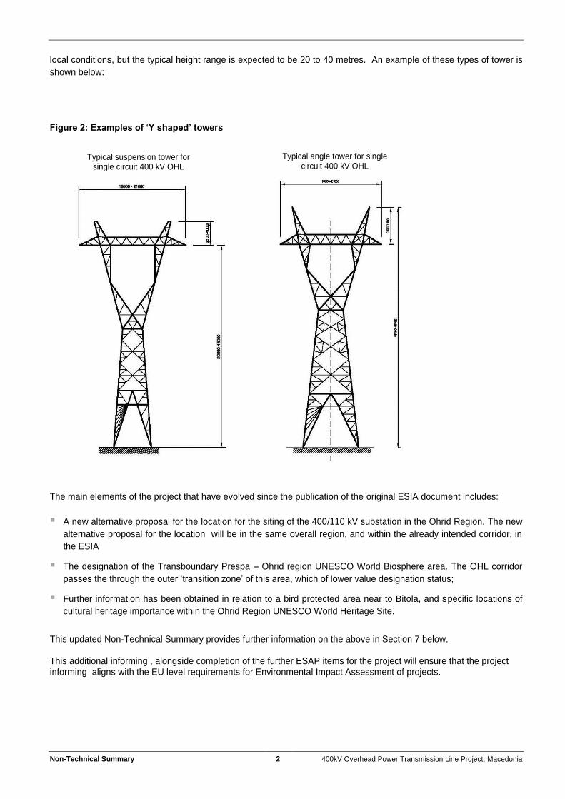
The project will include steel lattice Y type towers to be installed along the route. Suspension towers will be used
where the line is straight, and angle towers will be used by the conductor line needs to change direction. It is currently
estimated that 250 towers will be installed along the transmission line route. The towers will vary in height according to
Non-Technical Summary 2 400kV Overhead Power Transmission Line Project, Macedonia
local conditions, but the typical height range is expected to be 20 to 40 metres. An example of these types of tower is
shown below:
Figure 2: Examples of ‘Y shaped’ towers
The main elements of the project that have evolved since the publication of the original ESIA document includes:
A new alternative proposal for the location for the siting of the 400/110 kV substation in the Ohrid Region. The new
alternative proposal for the location will be in the same overall region, and within the already intended corridor, in
the ESIA
The designation of the Transboundary Prespa – Ohrid region UNESCO World Biosphere area. The OHL corridor
passes the through the outer ‘transition zone’ of this area, which of lower value designation status;
Further information has been obtained in relation to a bird protected area near to Bitola, and specific locations of
cultural heritage importance within the Ohrid Region UNESCO World Heritage Site.
This updated Non-Technical Summary provides further information on the above in Section 7 below. This additional informing , alongside completion of the further ESAP items for the project will ensure that the project informing aligns with the EU level requirements for Environmental Impact Assessment of projects.
Typical angle tower for single circuit 400 kV OHL
Typical suspension tower for single circuit 400 kV OHL
Non-Technical Summary 3 400kV Overhead Power Transmission Line Project, Macedonia
3 WHY IS THIS DEVELOPMENT REQUIRED?
The development is required in order to assist the stabilisation of power provision across the Southern Balkans and the wider regions. The project is part of an internationally important power transmission corridor running East – West from Bulgaria, Macedonia, Albania and to Italy (via a submarine cable). To ensure completion of the network across the region, there is the need to complete the 100km section of 400kV overhead transmission line from Bitola and across the south of the Republic of Macedonia, and connecting into Albania in the Lake Ohrid region. The development of a new 400kV /110kV substation in the region to the north of Lake Ohrid is also required, to allow improved and stabilised power provision to the south – western region of the transmission network of Macedonia.
4 WHERE WILL THE PROJECT BE LOCATED?
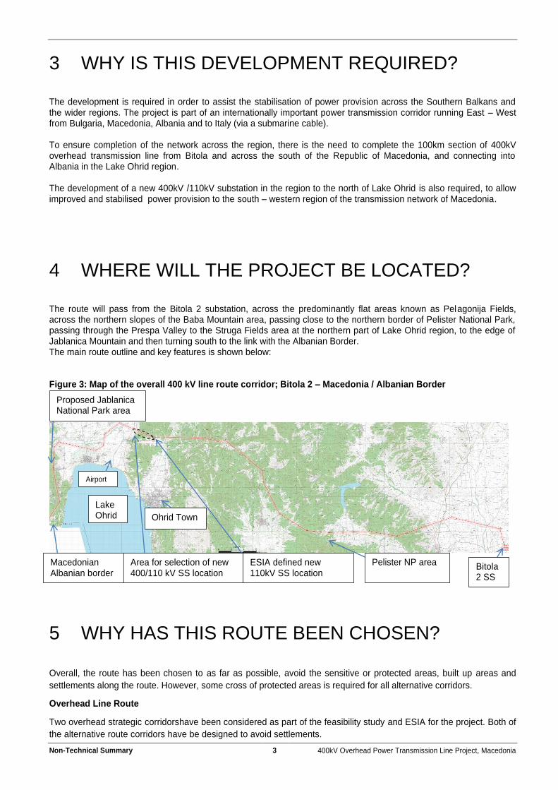
The route will pass from the Bitola 2 substation, across the predominantly flat areas known as Pelagonija Fields, across the northern slopes of the Baba Mountain area, passing close to the northern border of Pelister National Park, passing through the Prespa Valley to the Struga Fields area at the northern part of Lake Ohrid region, to the edge of Jablanica Mountain and then turning south to the link with the Albanian Border. The main route outline and key features is shown below: Figure 3: Map of the overall 400 kV line route corridor; Bitola 2 – Macedonia / Albanian Border
5 WHY HAS THIS ROUTE BEEN CHOSEN?
Overall, the route has been chosen to as far as possible, avoid the sensitive or protected areas, built up areas and
settlements along the route. However, some cross of protected areas is required for all alternative corridors.
Overhead Line Route
Two overhead strategic corridorshave been considered as part of the feasibility study and ESIA for the project. Both of
the alternative route corridors have be designed to avoid settlements.
Sainshand
Bitola 2 SS
Lake Ohrid
Macedonian Albanian border
ESIA defined new 110kV SS location
Area for selection of new 400/110 kV SS location
Proposed Jablanica National Park area
Pelister NP area
Ohrid Town
Airport
Non-Technical Summary 4 400kV Overhead Power Transmission Line Project, Macedonia
The first route avoided the area to the north of Lake Ohrid, and instead, heading south from the Resen area and
towards the Albanian border. This route would then need to pass through the Galicia National Park in Macedonia, and
then the Prespa National Park in Albania. The Galicia area is also classed as an ‘Emerald Site’ for nature
conservation so has additional international protection. This route would pass through the Galicia National Park for
some 11km, and through the core park area. The route would also pass through the core area of the more recently
designated UNESCO Transboundary Biosphere Reserve – Ohrid / Prespa Watershed region (see section 9 below for
more details).
The second route , and chosen route, again avoids settlements along the route, but does pass through the north part
of the UNESCO designated Ohrid region, which now includes the Unesco Transboundary Biosphere Reserve, but only
the outer ‘buffer zone’ and not the core protected region that the alternative route would impact. This route will also
pass along the boundaries of the proposed Jablanica National Park area, but only marginally into the park area,
adjacent to the proposed park boundary in order to avoid settlements. This is not the core interest area of the
proposed Park.
Therefore, the route through the Struga region to the north of Lake Ohrid has been selected, as this provides the best
option in terms of protected areas, overall sensitivities and avoiding the areas of most important conservation value.
As the project progresses into the detailed design stage, alternatives for the line routing within the overall corridor will
be assessed, to ensure that impacts associated with land acquisition and current land uses will be minimized as far
possible.
Ohrid Region Substation Location
A number of alternative locations for the Ohrid region 400/110kV substation have been considered. This is an area
that there have been further developments, which is discussed in Section 7 of this NTS.
6 WHAT IS THE BENEFIT OF THE PROJECT TO THE LOCAL PEOPLE AND THE ECONOMY?
The project will benefit the entire Southern Balkans regions, bring more stabilised power provision and increased
opportunities for power source provision into the region, as well as stimulating and improving the international energy
market across the region.
Within the south-western region of the transmission network in Macedonia, additional adequate future supply will be
ensured into the distribution consumers in the region, in future, bringing better stability, allowing future development of
this region important for tourism in Macedonia and reducing power cut events.
More directly, up to 270 jobs will be created during the construction phase of the project. Skills will be required across
the broad range of construction activities and priority would be given to the populations in the project affected area
where possible. Future maintenance of the transmission lines would fall into the current maintenance responsibility of
MEPSO, and it is not anticipated that a significant number of long term jobs would be created in this maintenance
work.
7 WHAT HAS CHANGED SINCE THE ORIGINAL ESIA DISCLOSURE?
The Environmental and Social Impact Assessment for the project was produced in January 2013. Since this time,
there have been a number of progressions in the project and in relation to some general development for the project.
This section provides and update on this information. Further assessments will be undertaken as part of the agreed
Environmental and Social Action Plan for the project, which has been fully updated alongside this project NTS.

Non-Technical Summary 5 400kV Overhead Power Transmission Line Project, Macedonia
New alternative location of the Substation in the Ohrid Region
The ESIA considers three alternative locations for the development of the new substation in the Ohrid Region. The
ESIA also considers the positive and negative aspects of all three potential locations. The ESIA then identifies a single
site as the preferred location (location 3 – north west from the Livoista Village).
Figure 4: Map – ESIA Defined Preferred Substation Location and Access Roads:
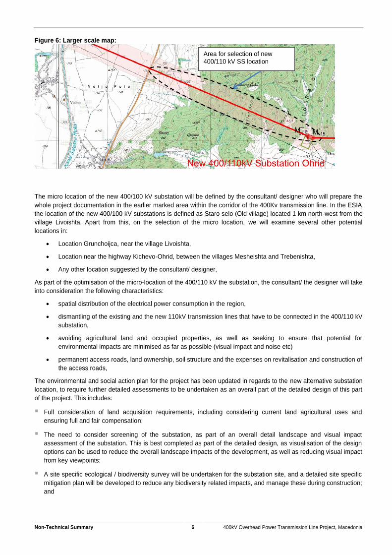
Since the publication of the ESIA, MEPSO has identified additional new options for the 400/110kV substation location.
The map below shows the area where the approximate location of the new intended site for the 400/110kV substation
will be selected.
Figure 5: Map – Selection area of the new location of the newly intended (Post ESIA) 400/110kV substation location:
Access road
Area for selection of new 400/110 kV SS location
Non-Technical Summary 6 400kV Overhead Power Transmission Line Project, Macedonia
Figure 6: Larger scale map:
The micro location of the new 400/100 kV substation will be defined by the consultant/ designer who will prepare the
whole project documentation in the earlier marked area within the corridor of the 400Kv transmission line. In the ESIA
the location of the new 400/100 kV substations is defined as Staro selo (Old village) located 1 km north-west from the
village Livoishta. Apart from this, on the selection of the micro location, we will examine several other potential
locations in:
Location Grunchoijca, near the village Livoishta,
Location near the highway Kichevo-Ohrid, between the villages Mesheishta and Trebenishta,
Any other location suggested by the consultant/ designer,
As part of the optimisation of the micro-location of the 400/110 kV the substation, the consultant/ the designer will take
into consideration the following characteristics:
spatial distribution of the electrical power consumption in the region,
dismantling of the existing and the new 110kV transmission lines that have to be connected in the 400/110 kV
substation,
avoiding agricultural land and occupied properties, as well as seeking to ensure that potential for
environmental impacts are minimised as far as possible (visual impact and noise etc)
permanent access roads, land ownership, soil structure and the expenses on revitalisation and construction of
the access roads,
The environmental and social action plan for the project has been updated in regards to the new alternative substation
location, to require further detailed assessments to be undertaken as an overall part of the detailed design of this part
of the project. This includes:
Full consideration of land acquisition requirements, including considering current land agricultural uses and
ensuring full and fair compensation;
The need to consider screening of the substation, as part of an overall detail landscape and visual impact
assessment of the substation. This is best completed as part of the detailed design, as visualisation of the design
options can be used to reduce the overall landscape impacts of the development, as well as reducing visual impact
from key viewpoints;
A site specific ecological / biodiversity survey will be undertaken for the substation site, and a detailed site specific
mitigation plan will be developed to reduce any biodiversity related impacts, and manage these during construction;
and
Area for selection of new 400/110 kV SS location

Non-Technical Summary 7 400kV Overhead Power Transmission Line Project, Macedonia
The new alternative substation location will be additionally evaluated for any risk in relation to cultural heritage. The
whole project would employ a ‘chance find’ procedure to ensure that any find during excavations processes are
properly managed.
UNESCO Ohrid-Prespa Transboundary Biosphere Reserve
On the 13th October 2014, UNESCO completed the inauguration of the designation of the Ohrid and Prespa Region as
a UNESCO World Network of Biosphere Reserves. It is stated that work to officially designate the area as a UNESCO World Biosphere Reserve commenced in 1996. Key details on the Reserve includes: “The landscape of the transboundary biosphere reserve is a balanced combination of water bodies, and surrounding mountains bordered by flat areas on its external boundaries. With an area of 446,244 hectares and a population of about 455,000, it includes part of Lake Ohrid and its surroundings in the Republic of Macedonia, which are inscribed on the World Heritage List, as well as part of Lake Orhid in Albania”.
Non-Technical Summary 8 400kV Overhead Power Transmission Line Project, Macedonia
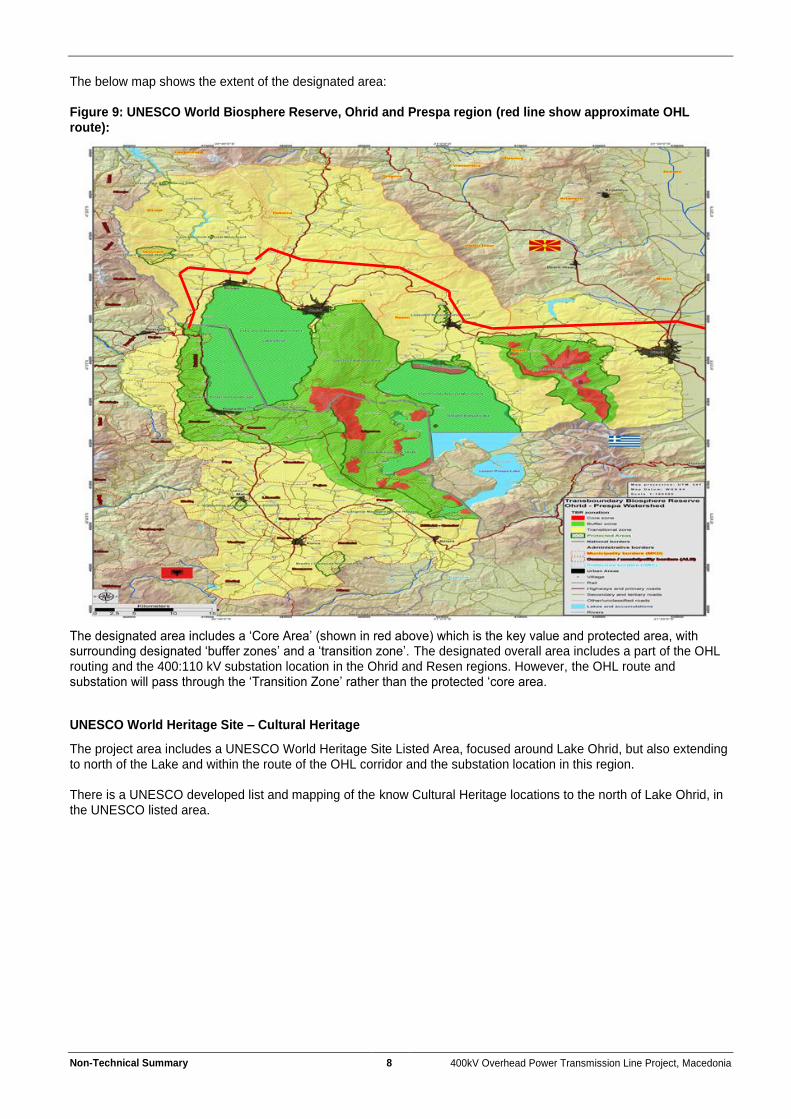
The below map shows the extent of the designated area: Figure 9: UNESCO World Biosphere Reserve, Ohrid and Prespa region (red line show approximate OHL route):
The designated area includes a ‘Core Area’ (shown in red above) which is the key value and protected area, with surrounding designated ‘buffer zones’ and a ‘transition zone’. The designated overall area includes a part of the OHL routing and the 400:110 kV substation location in the Ohrid and Resen regions. However, the OHL route and substation will pass through the ‘Transition Zone’ rather than the protected ‘core area.
UNESCO World Heritage Site – Cultural Heritage
The project area includes a UNESCO World Heritage Site Listed Area, focused around Lake Ohrid, but also extending to north of the Lake and within the route of the OHL corridor and the substation location in this region. There is a UNESCO developed list and mapping of the know Cultural Heritage locations to the north of Lake Ohrid, in the UNESCO listed area.
Non-Technical Summary 9 400kV Overhead Power Transmission Line Project, Macedonia
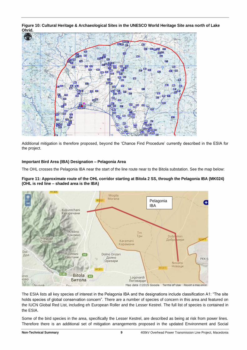
Figure 10: Cultural Heritage & Archaeological Sites in the UNESCO World Heritage Site area north of Lake Ohrid.
Additional mitigation is therefore proposed, beyond the ‘Chance Find Procedure’ currently described in the ESIA for the project.
Important Bird Area (IBA) Designation – Pelagonia Area
The OHL crosses the Pelagonia IBA near the start of the line route near to the Bitola substation. See the map below: Figure 11: Approximate route of the OHL corridor starting at Bitola 2 SS, through the Pelagonia IBA (MK024) (OHL is red line – shaded area is the IBA)
The ESIA lists all key species of interest in the Pelagonia IBA and the designations include classification A1: “The site
holds species of global conservation concern”. There are a number of species of concern in this area and featured on
the IUCN Global Red List, including eh European Roller and the Lesser Kestrel. The full list of species is contained in
the ESIA.
Some of the bird species in the area, specifically the Lesser Kestrel, are described as being at risk from power lines.
Therefore there is an additional set of mitigation arrangements proposed in the updated Environment and Social
Pelagonia IBA
Non-Technical Summary 10 400kV Overhead Power Transmission Line Project, Macedonia
Action Plan, which will include direct involvement from a Bird Specialist (Ornithologist) during the design of the OHL
routing in this area, to ensure that the most sensitive areas are avoided. Further general practice design requirements
related to siting and clustering of towers and the use of bird diverters on the conductors will also be included alongside
the use of ‘bird friendly’ conductors along.
Each tower location will be subject to a detailed on site biodiversity survey as a feature of the mitigation agreed in the
original ESIA.
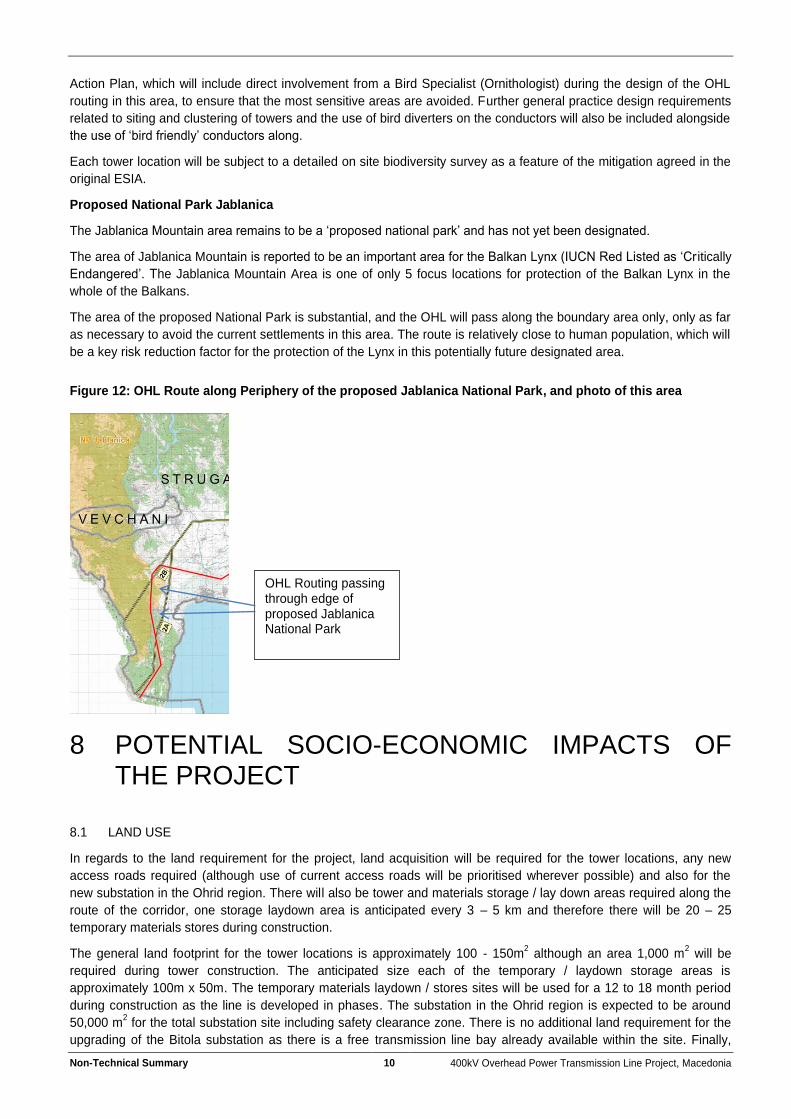
Proposed National Park Jablanica
The Jablanica Mountain area remains to be a ‘proposed national park’ and has not yet been designated.
The area of Jablanica Mountain is reported to be an important area for the Balkan Lynx (IUCN Red Listed as ‘Cr itically
Endangered’. The Jablanica Mountain Area is one of only 5 focus locations for protection of the Balkan Lynx in the
whole of the Balkans.
The area of the proposed National Park is substantial, and the OHL will pass along the boundary area only, only as far
as necessary to avoid the current settlements in this area. The route is relatively close to human population, which will
be a key risk reduction factor for the protection of the Lynx in this potentially future designated area.
Figure 12: OHL Route along Periphery of the proposed Jablanica National Park, and photo of this area
8 POTENTIAL SOCIO-ECONOMIC IMPACTS OF THE PROJECT
8.1 LAND USE
In regards to the land requirement for the project, land acquisition will be required for the tower locations, any new
access roads required (although use of current access roads will be prioritised wherever possible) and also for the
new substation in the Ohrid region. There will also be tower and materials storage / lay down areas required along the
route of the corridor, one storage laydown area is anticipated every 3 – 5 km and therefore there will be 20 – 25
temporary materials stores during construction.
The general land footprint for the tower locations is approximately 100 - 150m2 although an area 1,000 m
2 will be
required during tower construction. The anticipated size each of the temporary / laydown storage areas is
approximately 100m x 50m. The temporary materials laydown / stores sites will be used for a 12 to 18 month period
during construction as the line is developed in phases. The substation in the Ohrid region is expected to be around
50,000 m2 for the total substation site including safety clearance zone. There is no additional land requirement for the
upgrading of the Bitola substation as there is a free transmission line bay already available within the site. Finally,
OHL Routing passing through edge of proposed Jablanica National Park

Non-Technical Summary 11 400kV Overhead Power Transmission Line Project, Macedonia
there will also be the need to designate a number of ‘winch sites’ along the route, which will be used for pulling the
conductor lines into place between the towers. These winch sites will be temporary and require a land plot of circa
6,000 m2 during temporary construction use.
Currently, it is not envisaged any resettlement will be required as a result of the project as the routing of the line within
the project corridor can ensure that any settlement requirement will be avoided. A safety protection zone will be
retained, to ensure that the conductor lines and towers are a safe distance from all occupied areas, and will also avoid
any potential for nuisance to be caused as a result of impacts such as noise. However, there will not be any other land
use restrictions within this safety protection zone, the areas will remain suitable for agricultural or other land uses in
the areas along the line route and safety zone.
In order to ensure that all land owners and users are fairly and transparently compensated for any loss of land or land
access, a Land Acquisition and Compensation Framework has been developed, which details requirements that will
need to be followed in developing and implementing a detailed Land Acquisition and Compensation Plan once the
exact route and related land-take requirements are known.
8.2 SOCIAL INVESTMENT
The development of the project in the region would bring additional employment (estimated at 270 new jobs) on a
temporary basis during construction, and there would be potential for locally sourced supply contracts for general
construction materials such as concrete and aggregates.
9 WHAT WILL BE THE KEY ENVIRONMENTAL IMPACTS OF THE PROJECT AND HOW WILL THEY BE MITIGATED?
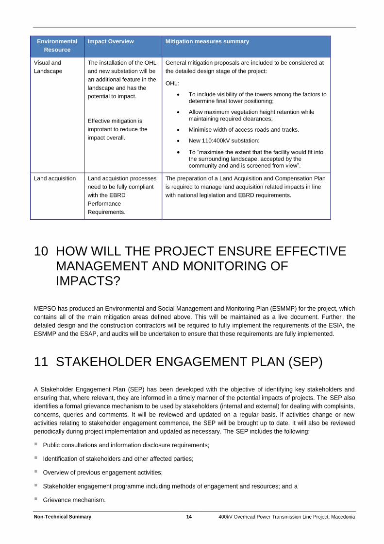
The potential impacts of the project and the key areas of mitigation are presented below:
Table 1: Environmental Impact Summary and Key Mitigation
Environmental
Resource
Impact Overview Mitigation measures summary
Climate and Air
Quality
Limited potential for
impact, other than from
dust very local to
construction operations
and only during
construction.
General mitigation measure include techniques such as:
dampening of roads and stockpile areas;
speed control on access roads;
Minimise open excavation areas;
Re-seeding of open earthworks areas;
Maintain construction machinery;
Ban burning of materials on site;
Sheeting of vehicles carrying aggregates and soils;
General observation of dust levels and enhancing mitigation if issues become apparent.
Noise and
Vibration
The only source of noise
and vibration would be
temporary during
construction, or th low
frequency ’humming’ from
the power lines during
operation, this noise
No occupied buildings will be located within 50
meters of the line route / tower location wherever
possible.
General good practice mitigation measures will be
implemented including:
General measures for reduction of equipment noise (eg silences on pneumatic tools / acoustic enclosures
Non-Technical Summary 12 400kV Overhead Power Transmission Line Project, Macedonia
Environmental
Resource
Impact Overview Mitigation measures summary
source should not have
potential for impact beyond
a distance of 20 metres.
on compressors etc)
No helicopters will be used in construction, or if so, for a very short duration (1 minute – 1 hour).
Restriction of periods of operation. No night time or weekend construction unless specifically pre-agreed with local authorities and local residents.
Notification and engagement with all residents within 200 metres of any construction location. Noise monitoring would be undertaken in any sensitive areas closer to settelements identified.
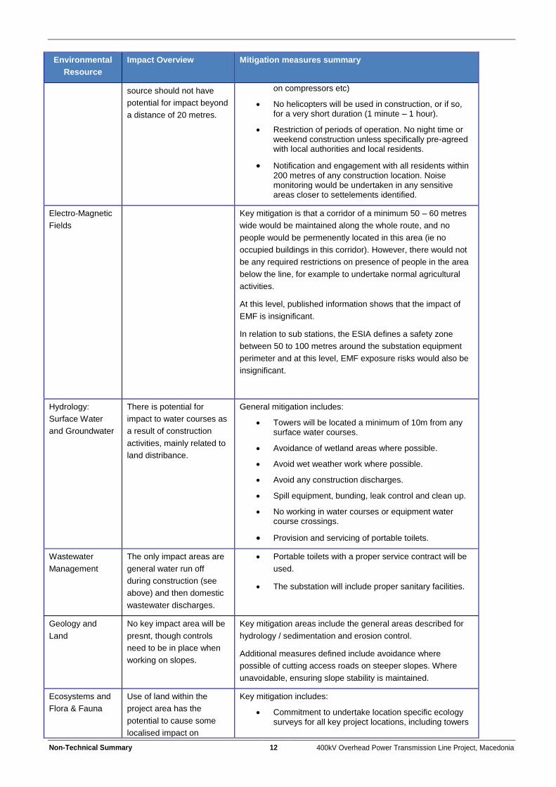
Electro-Magnetic
Fields
Key mitigation is that a corridor of a minimum 50 – 60 metres
wide would be maintained along the whole route, and no
people would be permenently located in this area (ie no
occupied buildings in this corridor). However, there would not
be any required restrictions on presence of people in the area
below the line, for example to undertake normal agricultural
activities.
At this level, published information shows that the impact of
EMF is insignificant.
In relation to sub stations, the ESIA defines a safety zone
between 50 to 100 metres around the substation equipment
perimeter and at this level, EMF exposure risks would also be
insignificant.
Hydrology:
Surface Water
and Groundwater
There is potential for
impact to water courses as
a result of construction
activities, mainly related to
land distribance.
General mitigation includes:
Towers will be located a minimum of 10m from any surface water courses.
Avoidance of wetland areas where possible.
Avoid wet weather work where possible.
Avoid any construction discharges.
Spill equipment, bunding, leak control and clean up.
No working in water courses or equipment water course crossings.
Provision and servicing of portable toilets.
Wastewater
Management
The only impact areas are
general water run off
during construction (see
above) and then domestic
wastewater discharges.
Portable toilets with a proper service contract will be
used.
The substation will include proper sanitary facilities.
Geology and
Land
No key impact area will be
presnt, though controls
need to be in place when
working on slopes.
Key mitigation areas include the general areas described for
hydrology / sedimentation and erosion control.
Additional measures defined include avoidance where
possible of cutting access roads on steeper slopes. Where
unavoidable, ensuring slope stability is maintained.
Ecosystems and
Flora & Fauna
Use of land within the
project area has the
potential to cause some
localised impact on
Key mitigation includes:
Commitment to undertake location specific ecology surveys for all key project locations, including towers
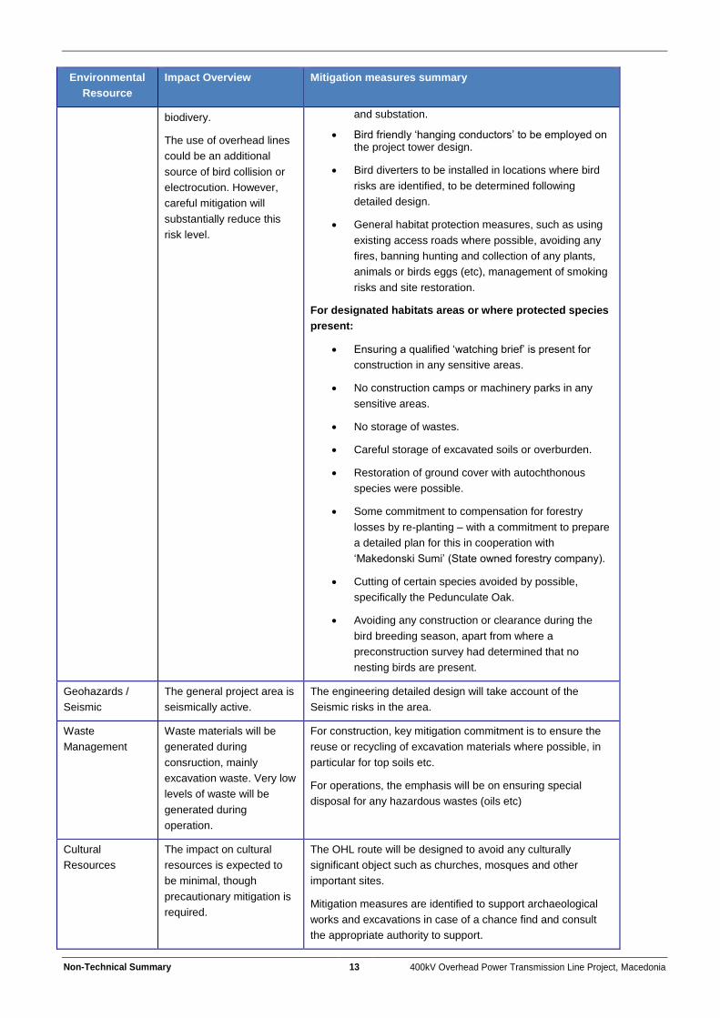
Non-Technical Summary 13 400kV Overhead Power Transmission Line Project, Macedonia
Environmental
Resource
Impact Overview Mitigation measures summary
biodivery.
The use of overhead lines
could be an additional
source of bird collision or
electrocution. However,
careful mitigation will
substantially reduce this
risk level.
and substation.
Bird friendly ‘hanging conductors’ to be employed on the project tower design.
Bird diverters to be installed in locations where bird
risks are identified, to be determined following
detailed design.
General habitat protection measures, such as using
existing access roads where possible, avoiding any
fires, banning hunting and collection of any plants,
animals or birds eggs (etc), management of smoking
risks and site restoration.
For designated habitats areas or where protected species
present:
Ensuring a qualified ‘watching brief’ is present for
construction in any sensitive areas.
No construction camps or machinery parks in any
sensitive areas.
No storage of wastes.
Careful storage of excavated soils or overburden.
Restoration of ground cover with autochthonous
species were possible.
Some commitment to compensation for forestry
losses by re-planting – with a commitment to prepare
a detailed plan for this in cooperation with
‘Makedonski Sumi’ (State owned forestry company).
Cutting of certain species avoided by possible,
specifically the Pedunculate Oak.
Avoiding any construction or clearance during the
bird breeding season, apart from where a
preconstruction survey had determined that no
nesting birds are present.
Geohazards /
Seismic
The general project area is
seismically active.
The engineering detailed design will take account of the
Seismic risks in the area.
Waste
Management
Waste materials will be
generated during
consruction, mainly
excavation waste. Very low
levels of waste will be
generated during
operation.
For construction, key mitigation commitment is to ensure the
reuse or recycling of excavation materials where possible, in
particular for top soils etc.
For operations, the emphasis will be on ensuring special
disposal for any hazardous wastes (oils etc)
Cultural
Resources
The impact on cultural
resources is expected to
be minimal, though
precautionary mitigation is
required.
The OHL route will be designed to avoid any culturally
significant object such as churches, mosques and other
important sites.
Mitigation measures are identified to support archaeological
works and excavations in case of a chance find and consult
the appropriate authority to support.
Non-Technical Summary 14 400kV Overhead Power Transmission Line Project, Macedonia
Environmental
Resource
Impact Overview Mitigation measures summary
Visual and
Landscape
The installation of the OHL
and new substation will be
an additional feature in the
landscape and has the
potential to impact.
Effective mitigation is
improtant to reduce the
impact overall.
General mitigation proposals are included to be considered at
the detailed design stage of the project:
OHL:
To include visibility of the towers among the factors to determine final tower positioning;
Allow maximum vegetation height retention while maintaining required clearances;
Minimise width of access roads and tracks.
New 110:400kV substation:
To “maximise the extent that the facility would fit into the surrounding landscape, accepted by the community and and is screened from view”.
Land acquisition Land acquistion processes
need to be fully compliant
with the EBRD
Performance
Requirements.
The preparation of a Land Acquisition and Compensation Plan
is required to manage land acquisition related impacts in line
with national legislation and EBRD requirements.
10 HOW WILL THE PROJECT ENSURE EFFECTIVE MANAGEMENT AND MONITORING OF IMPACTS?
MEPSO has produced an Environmental and Social Management and Monitoring Plan (ESMMP) for the project, which
contains all of the main mitigation areas defined above. This will be maintained as a live document. Further , the
detailed design and the construction contractors will be required to fully implement the requirements of the ESIA, the
ESMMP and the ESAP, and audits will be undertaken to ensure that these requirements are fully implemented.
11 STAKEHOLDER ENGAGEMENT PLAN (SEP)
A Stakeholder Engagement Plan (SEP) has been developed with the objective of identifying key stakeholders and
ensuring that, where relevant, they are informed in a timely manner of the potential impacts of projects. The SEP also
identifies a formal grievance mechanism to be used by stakeholders (internal and external) for dealing with complaints,
concerns, queries and comments. It will be reviewed and updated on a regular basis. If activities change or new
activities relating to stakeholder engagement commence, the SEP will be brought up to date. It will also be reviewed
periodically during project implementation and updated as necessary. The SEP includes the following:
Public consultations and information disclosure requirements;
Identification of stakeholders and other affected parties;
Overview of previous engagement activities;
Stakeholder engagement programme including methods of engagement and resources; and a
Grievance mechanism.

Non-Technical Summary 15 400kV Overhead Power Transmission Line Project, Macedonia
Stakeholders could be individuals and organisations that may be directly or indirectly affected by the project either in a
positive or negative way, who wish to express their views.
A Land Acquisition and Compensation Framework has also been developed for use by MEPSO for the project. This
document sets out the principles for full consideration of all interested parties in relation to the acquisition, lease and
use of land, and includes a framework for the full assessment of these interests and the integration of required
controls, potentially including compensatory measures if needed.
12 FURTHER INFORMATION
Contact information for this project is provided below:
MEPSO Skopje Head Office
AD MEPSO, Skopje
Vesna Drejovska
Str . Maksim GorkI No. 4 , 1000 Skopje ;
Tel: 02 3149600 Fax : 02 3111 160
email: [email protected] Website:
http://www.mepso.com.mk/en-us/Details.aspx?categoryID=230
Copies of the Environmental and Social Impact Assessment will be publicly available at the above addresses and are
available on the internet at the web address above.