adde server concepts - university of … server concepts ... (where #### is a value from 0001-9999)...
TRANSCRIPT

ADDE Server Concepts
Dave Santek and Russ Dengel
Space Science and Engineering Center
2016 McIDAS Users’ Group Meeting
Madison,WI
14 November 2016
1
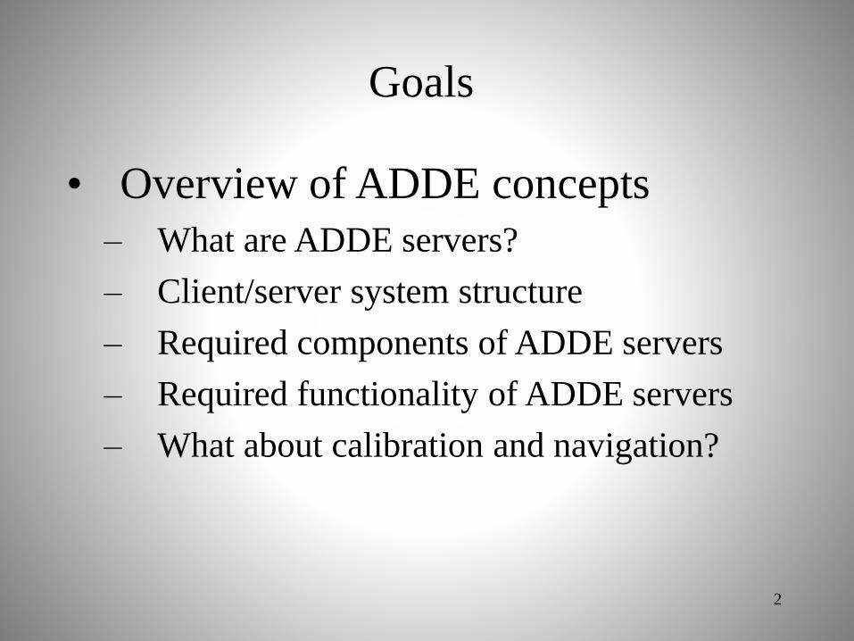
Goals
• Overview of ADDE concepts
– What are ADDE servers?
– Client/server system structure
– Required components of ADDE servers
– Required functionality of ADDE servers
– What about calibration and navigation?
2

Topics
• Overview of Abstract Data
Distribution Environment (ADDE)
– Image data
– Client and server aspects
– Directory and data server
• McIDAS Area file structure
3

Topics
• ADDE low-level details
• Required components for ADDE
servers
• Required functionality for ADDE
servers
• Calibration and navigation modules
4

What are ADDE servers?
• Data file format converter
• Obey protocol for local and remote
file access
• Features for efficient data transfer
• Features for integration into
McIDAS-X and -V
5
Client/Server system structure
6

NOAAPORT
Signal
Clients
Servers
7

Group NamesEASTWEST
Group NamesWALLOPSGILMOREPRODS
polar.ssec.wisc.edu geo.ssec.wisc.edu noaaport.ssec.wisc.edu
WALLOPSN14HRPTN15HRPTN16HRPTN14GACN15GACN16GAC
EASTCONUSNHFDSHSOUNDER
Group NamesRTPTSRCRTGRIDSRTWXTEXT
GILMOREN14HRPTN15HRPTN16HRPTN14GACN15GACN16GAC
PRODSSHMONTAGENHMONTAGENVDIFOGFIRES
WESTCONUSNHFDSHSOUNDER
RTPTSRCSFCHOURLYSYNOPTICSHIPBUOYUPPERMANDUPPERSIG
RTGRIDSETAAVNALLMISC
Group NamesMYDATAAZFIRECOFIREANDREW
AZFIRE11UMVISWVSFCOBSUPPERAIR
ANDREWRADARSFCOBSAIRCRAFT11UMVISWV
Group IP AddressWALLOPS polar.ssec.wisc.eduGILMORE polar.ssec.wisc.eduPRODS polar.ssec.wisc.eduEAST geo.ssec.wisc.eduWEST geo.ssec.wisc.eduRTGRIDS noaaport.ssec.wisc.eduRTPTSRC noaaport.ssec.wisc.eduRTWXTEXT noaaport.ssec.wisc.eduAZFIRE local-dataANDREW local-data
8

Server SideDSSERVE ADD group/descriptor format bfile efile [keywords] “descriptionDefines a dataset for the server workstation. Keywords may be required to add additional filename and location information. Group and descriptor are used by client commands to accessdatasets. Information stored in file named RESOLV.SRV.
Client SideDATALOC ADD group ip_addressCreates a table in MCTABLE.TXT so client commands can determine which server workstation is toreceive the ADDE request.
DSINFO type groupLists descriptors for type and group specified.
AKA alias group/descriptorCreates an alias for a group/descriptor pairing.
geo.ssec.wisc.edu
noaaport.ssec.wisc.edu
Client SideDATALOC ADD group ip_addressCreates a table in MCTABLE.TXT so client commands can determine which server workstation is toreceive the ADDE request.
DSINFO type groupLists descriptors for type and group specified.
AKA alias group/descriptorCreates an alias for a group/descriptor pairing.
Client SideDATALOC ADD group ip_addressCreates a table in MCTABLE.TXT so client commands can determine which server workstation is toreceive the ADDE request.
DSINFO type groupLists descriptors for type and group specified.
AKA alias group/descriptorCreates an alias for a group/descriptor pairing.
Client SideDATALOC ADD group ip_addressCreates a table in MCTABLE.TXT so client commands can determine which server workstation is toreceive the ADDE request.
DSINFO type groupLists descriptors for type and group specified.
AKA alias group/descriptorCreates an alias for a group/descriptor pairing.
Group IP AddressWALLOPS polar.ssec.wisc.eduPRODS polar.ssec.wisc.eduEAST geo.ssec.wisc.eduRTGRIDS noaaport.ssec.wisc.eduRTPTSRC noaaport.ssec.wisc.eduAZFIRE local-dataANDREW local-data
Server SideDSSERVE ADD group/descriptor format bfile efile [keywords] “descriptionDefines a dataset for the server workstation. Keywords may be required to add additional filename and location information. Group and descriptor are used by client commands to accessdatasets. Information stored in file named RESOLV.SRV.
Group NamesEASTWESTEAST
CONUSNHFDSHSOUNDER
WESTCONUSNHFDSHSOUNDER
Group NamesRTPTSRCRTGRIDSRTWXTEXT
RTPTSRCSFCHOURLYSYNOPTICSUIPBUOYUPPERMANDUPPERSIG
RTGRIDSETAAVNALLMISC
Group NamesMYDATAAZFIRECOFIREANDREW
AZFIRE11UMVISWVSFCOBSUPPERAIR
ANDREWRADARSFCOBSAIRCRAFT11UMVISWV
9
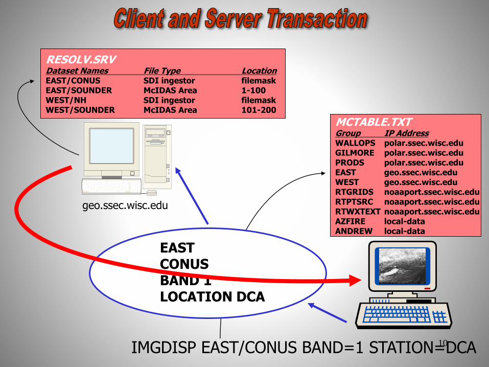
geo.ssec.wisc.edu
MCTABLE.TXTGroup IP AddressWALLOPS polar.ssec.wisc.eduGILMORE polar.ssec.wisc.eduPRODS polar.ssec.wisc.eduEAST geo.ssec.wisc.eduWEST geo.ssec.wisc.eduRTGRIDS noaaport.ssec.wisc.eduRTPTSRC noaaport.ssec.wisc.eduRTWXTEXT noaaport.ssec.wisc.eduAZFIRE local-dataANDREW local-data
RESOLV.SRVDataset Names File Type LocationEAST/CONUS SDI ingestor filemaskEAST/SOUNDER McIDAS Area 1-100WEST/NH SDI ingestor filemaskWEST/SOUNDER McIDAS Area 101-200
IMGDISP EAST/CONUS BAND=1 STATION=DCA
EASTCONUSBAND 1LOCATION DCA
10
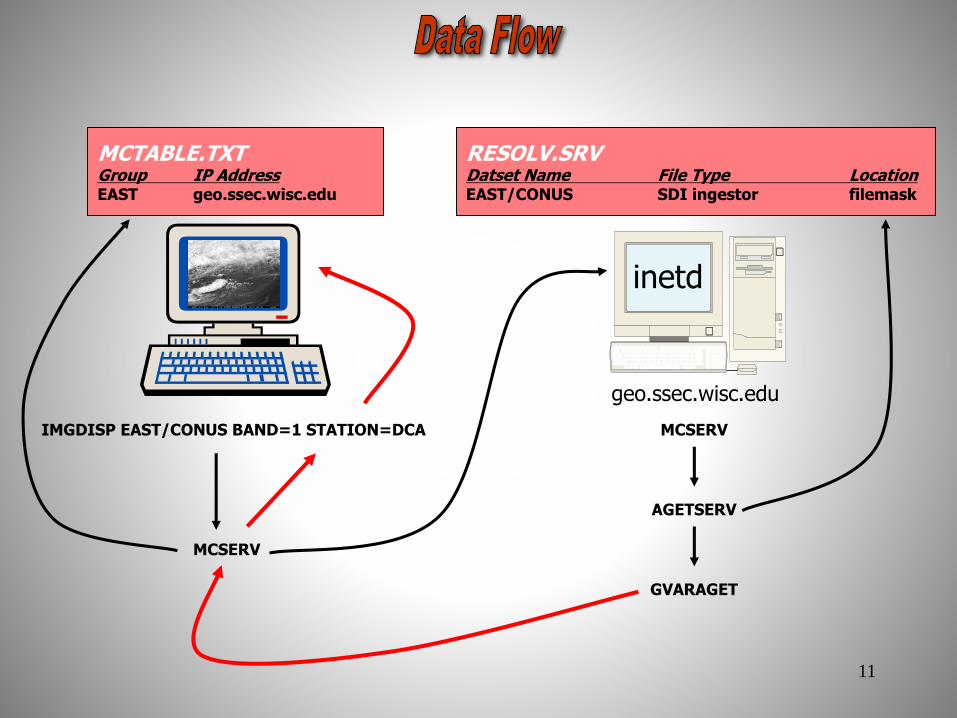
geo.ssec.wisc.edu
MCTABLE.TXTGroup IP AddressEAST geo.ssec.wisc.edu
RESOLV.SRVDatset Name File Type LocationEAST/CONUS SDI ingestor filemask
inetd
IMGDISP EAST/CONUS BAND=1 STATION=DCA MCSERV
MCSERV
AGETSERV
GVARAGET
11

ADDE
Under the Hood
12

Mechanism
• The client requests a connection to a
server
• The request causes the creation of a
pipe, a fork, and the exec of the
ADDE communications module,
mcserv
13

Mechanism
• The client transmits over the pipe, and
then receives on it
• A 16-byte preamble is sent from the
client:
– version number of the protocol: 0x0001
– IP address of the server machine
– port number: 112
– service name; for example:
aget14
Mechanism
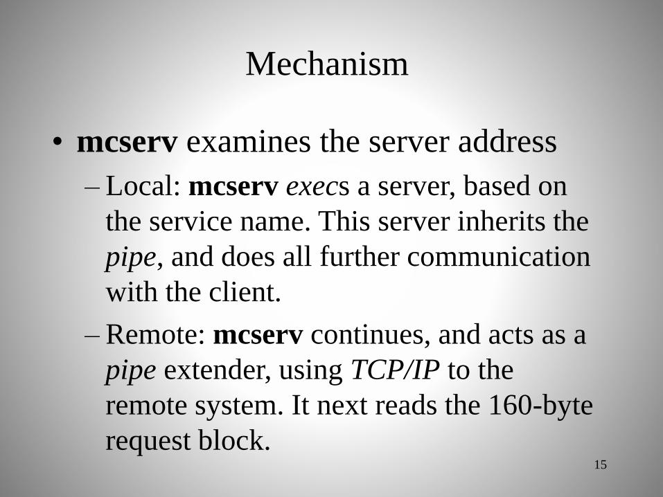
• mcserv examines the server address
– Local: mcserv execs a server, based on
the service name. This server inherits the
pipe, and does all further communication
with the client.
– Remote: mcserv continues, and acts as a
pipe extender, using TCP/IP to the
remote system. It next reads the 160-byte
request block.15
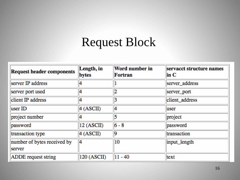
Request Block
16

Mechanism
• If mcserv succeeds in connecting to the port:
– Sends a resynthesized 16-byte preamble and 160-byte
request block to the server
– mcserv then reads and sends the number of bytes
stored in the input data length field
• All information has been sent to the server,
mcserv then:
– Continues as an intermediary between the client
application and the server
– Copies bytes sent by the server to the pipe being read
by the application.17

Mechanism
• On the remote server machine:
– a mcserv is started by inetd
– Same steps are followed, except now the
service is local
– mcserv execs the server based on the service
name, etc.
– When the server is finished sending its
response, it sends a 92-byte trailer block, and
exits.
18

Notes
• The design is stream oriented, so both the client
and the server can be working simultaneously
– The server locates the data and transmits it to the client
via a pipe and/or TCP/IP
– The client reads the pipe and operates on the data
– The pipe is a finite size:
• The server will wait to write if the pipe is full
• The client will wait to read if the pipe is empty
19

Notes
• By default, if 120 seconds elapse with no activity
on the pipe, the process stops. The process on the
other end of the pipe also stops at this time.
– The ADDETIMEOUT environment variable will adjust
the timeout if more or less time is appropriate for this
dataset
20
https://www.ssec.wisc.edu/mcidas/doc/users_guide/current/intro-34.html

McIDAS Area File Structure
21

Terminology
AREA#### McIDAS file that stores image data (where #### is a value from 0001-9999)
Directory First part of the AREA file which describes the image dataNavigation Information necessary to co-locate satellite data to positions on earthCalibration Information necessary to convert raw counts into meaningful physical quantitiesAux Block Auxiliary Information such as LALO navigationPrefix Header information for each line of data
AREA1234AREA1234
Directory
Calibration
Navigation
Aux Block
Prefix
Prefix
Prefix
Data
Data
Data
Directory
Navigation
Directory
Calibration
Navigation
Directory
Calibration
Navigation
Directory
Terminology
AREA#### McIDAS file that stores image data (where #### is a value from 0001-9999)
Directory First part of the AREA file which describes the image dataNavigation Information necessary to co-locate satellite data to positions on earthCalibration Information necessary to convert raw counts into meaningful physical quantitiesAux Block Auxiliary Information such as LALO navigationPrefix Header information for each line of data
Navigation
AREA1234AREA1234
Directory
Calibration
Navigation
Aux Block
Prefix
Prefix
Prefix
Data
Data
Data
Directory
Navigation
Directory
Calibration
Navigation
Directory
Calibration
Directory
Terminology
AREA#### McIDAS file that stores image data (where #### is a value from 0001-9999)
Directory First part of the AREA file which describes the image dataNavigation Information necessary to co-locate satellite data to positions on earthCalibration Information necessary to convert raw counts into meaningful physical quantitiesAux Block Auxiliary Information such as LALO navigationPrefix Header information for each line of data
AREA1234AREA1234
Directory
Calibration
Navigation
Aux Block
Prefix
Prefix
Prefix
Data
Data
Data
Directory
Navigation
Directory
Calibration
Navigation
Directory
Calibration
Navigation
Directory
File Structure
Terminology
AREA#### McIDAS file that stores image data (where #### is a value from 0001-9999)
Directory First part of the AREA file which describes the image dataNavigation Information necessary to co-locate satellite data to positions on earthCalibration Information necessary to convert raw counts into meaningful physical quantitiesAux Block Auxiliary Information such as LALO navigationPrefix Header information for each line of data
AREA1234AREA1234
Directory
Calibration
Navigation
Aux Block
Prefix
Prefix
Prefix
Data
Data
Data
Directory
Navigation
Directory
Calibration
Navigation
Directory
Calibration
Navigation
Directory
22

Validity code(valcode) A number that is used to determine if there is data for the line. This value is also stored in the area directory. Applications compare the valcode on the line with the valcode in the area directory. The line of data is considered missing if they do not match.
DOC Satellite specific documentation.
Calibration Coefficients required if calibration changes line by line.
Band list Ordered list of bands found on each line
CalibrationValiditycode
Bandlist
DOC CalibrationDOCValiditycode
DataPrefix
Validity code(valcode) A number that is used to determine if there is data for the line. This value is also stored in the area directory. Applications compare the valcode on the line with the valcode in the area directory. The line of data is considered missing if they do not match.
DOC Satellite specific documentation.
Calibration Coefficients required if calibration changes line by line.
Band list Ordered list of bands found on each line
CalibrationValiditycode
Bandlist
DOC
Line Prefix
Validity code(valcode) A number that is used to determine if there is data for the line. This value is also stored in the area directory. Applications compare the valcode on the line with the valcode in the area directory. The line of data is considered missing if they do not match.
DOC Satellite specific documentation.
Calibration Coefficients required if calibration changes line by line.
Band list Ordered list of bands found on each line
CalibrationValiditycode
Bandlist
DOC
Validity code(valcode) A number that is used to determine if there is data for the line. This value is also stored in the area directory. Applications compare the valcode on the line with the valcode in the area directory. The line of data is considered missing if they do not match.
DOC Satellite specific documentation.
Calibration Coefficients required if calibration changes line by line.
Band list Ordered list of bands found on each line.
CalibrationValiditycode
Bandlist
DOC
23

Image file directory listing for:EASTL/CONUS
Pos Satellite/ Date Time Center Res (km) Image_Size
sensor Lat Lon Lat Lon
--- ------------- ------------ -------- ---- ---- ----- ----- ------------
157 G-8 IMG 18 JUL 02199 18:45:00 22 71
Band: 1 0.65 um Visible - Cloud Cover 1.13 0.58 4988 x13852
Band: 2 3.9 um Night clouds; shortwave window 4.53 2.33 1247 x 3463
Band: 3 6.8 um Upper level water vapor 4.53 2.33 1247 x 3463
Band: 4 10.7 um Surface temp; longwave window 4.53 2.33 1247 x 3463
Band: 5 12.0 um Sea surface temp and water vapor 4.53 2.33 1247 x 3463
proj: 0 created: 2002199 184515 memo: RT GVAR
type:GVAR cal type:RAW
offsets: data= 3328 Calibration= 256 Navigation= 2816 Auxiliary= 0
doc length: 228 cal length: 0 lev length: 0 PREFIX= 232
valcod: 199184500 zcor: 0 avg-smp: N
start yyddd: 2002199 start time:184515 start scan: 401
lcor: 3205 ecor: 9049 bytes per pixel: 2 ss: 70
Resolution Factors (base=1): Line= 4.0 Element= 4.0
AREA Directory
Image file directory listing for:EASTL/CONUS
Pos Satellite/ Date Time Center Res (km) Image_Size
sensor Lat Lon Lat Lon
--- ------------- ------------ -------- ---- ---- ----- ----- ------------
157 G-8 IMG 18 JUL 02199 18:45:00 22 71
Band: 1 0.65 um Visible - Cloud Cover 1.13 0.58 4988 x13852
Band: 2 3.9 um Night clouds; shortwave window 4.53 2.33 1247 x 3463
Band: 3 6.8 um Upper level water vapor 4.53 2.33 1247 x 3463
Band: 4 10.7 um Surface temp; longwave window 4.53 2.33 1247 x 3463
Band: 5 12.0 um Sea surface temp and water vapor 4.53 2.33 1247 x 3463
proj: 0 created: 2002199 184515 memo: RT GVAR
type:GVAR cal type:RAW
offsets: data= 3328 Calibration= 256 Navigation= 2816 Auxiliary= 0
doc length: 228 cal length: 0 lev length: 0 PREFIX= 232
valcod: 199184500 zcor: 0 avg-smp: N
start yyddd: 2002199 start time:184515 start scan: 401
lcor: 3205 ecor: 9049 bytes per pixel: 2 ss: 70
Resolution Factors (base=1): Line= 4.0 Element= 4.0
24

IMGDISP EAST/CONUS BAND=4 STATION=DCA
Raw Counts
Inverse Planck Equation or LUT
Temperatures
Calibration Modules
GMS
GVAR
MSAT
AVHR
Radiance Valuesalbedo
Standard GOES Temperature to Grayscale Conversion
Grayscale Values (BRIT)
geo.ssec.wisc.edu
inetd
Raw Counts
BRITTemperatureRadiance
BRITTemperatureRadiance
25

Writing an ADDE Server
26

Two servers required
• Directory server returns
– Area directory
– Ancillary information
• Data server returns
– Data as Area format (including directory)
27
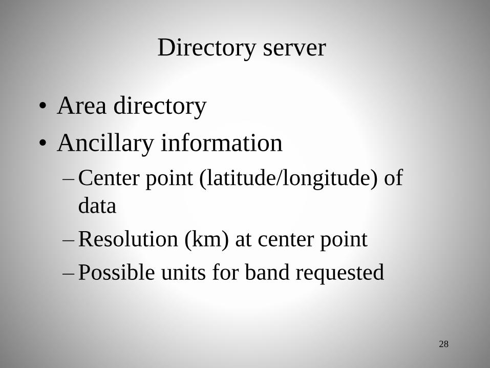
Directory server
• Area directory
• Ancillary information
– Center point (latitude/longitude) of
data
– Resolution (km) at center point
– Possible units for band requested
28

Data server: File converter Image data
• Reformat input file into a
representation (Image Object) of a
McIDAS-X Area file
• ADDE protocol returns Image
Object to client application
• McIDAS-X application-compatible
29

ADDE protocol
• Data delivery protocol (via TCP/IP)
developed at SSEC in the mid-1990s
• Protocols for image, grid, point, and
text data
• Local and remote data access are
handled the same
30

Flexible and efficient data access
1. Region of interest specification
2. Spectral subsecting
3. Unit conversion
4. Other features
31
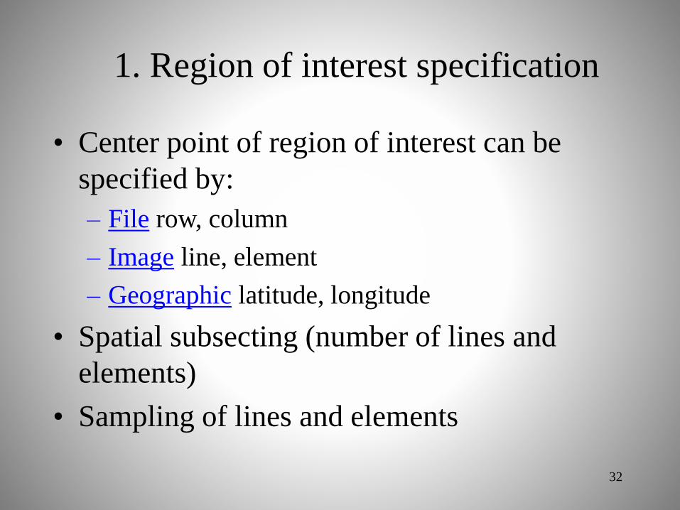
1. Region of interest specification
• Center point of region of interest can be
specified by:
– File row, column
– Image line, element
– Geographic latitude, longitude
• Spatial subsecting (number of lines and
elements)
• Sampling of lines and elements
32

2. Spectral subsecting
• For multi-banded data, return:
– Single band (required)
– All bands (if possible)
– Multi-bands (optional)
33

3. Unit conversion
• Convention: By default, retain data values
as stored in file (RAW values)
• At a minimum, a 1-byte grayscale value
must be returned (BRIT)
34

3. Unit conversion
• Convert to useful units as requested by user,
typically:
– Infrared satellite data: conversions to radiance
(RAD) and brightness temperature (TEMP)
– Visible satellite data: conversions to reflectance
(REF) or albedo (ALB)
• Other units can be defined, which are
incorporated into a calibration module
35

4. Other features
• Return data values as 1-, 2-, or 4-byte
(spacing)
– Return in the most compact format
– If data can not be returned in requested spacing,
return error
• If possible, return values as unsigned
integers
36

Navigation and Calibration
modules
37

http://www.ssec.wisc.edu/mcidas/doc/prog_man/current/access-6.html#30949
Navigation Modules
38
• Subsystem for adding new navigation type
• Each navigation module is a collection of
four functions:
– Defined API
– Recollecting McIDAS-X is all that is needed

http://www.ssec.wisc.edu/mcidas/doc/prog_man/current/access-6.html#30949
Navigation Modules
39
• Naming convention, for example:– GOES-R ABI ABIN nvxabin.dlm
– Rectilinear RECT nvxrect.dlm
• Four required functions:– NVXINI Initialization
– NVXEAS Earth to satellite coordinate transform
– NVXSAE Satellite coordinate to Earth transform
– NVXOPT Optional transforms (e.g., satellite subpoint)

http://www.ssec.wisc.edu/mcidas/doc/prog_man/current/access-6.html#30949
Navigation Modules
40
• Writing in Fortran recommended
• Pre-compiler step (convdlm) renames the
common functions to unique names, for example
for ABIN:• NVXINI => NV1INIABIN
– Generates source file nvprep.f

http://www.ssec.wisc.edu/mcidas/doc/prog_man/current/formats-13a.html#LALO
Navigation Modules
41
• Consider using LALO navigation
– Latitude/longitude point every nth line and element
– Good for low-volume images (< 2,000,000 points) or
when sampling lat/lon values is possible
(approximately linear variation within the sampled
box)

http://www.ssec.wisc.edu/mcidas/doc/prog_man/current/access-7.html#23725
Calibration Modules
42
• Subsystem for adding new calibration type
• Each calibration module is a collection of
three functions:
– Defined API
– Recollecting McIDAS-X is all that is needed

Calibration Modules
43
• Naming convention, for example:– GOES-R ABI ABI kbxabi.dlm
– Product PRD kbxprd.dlm
• Three required functions:– KBXINI Initialization
– KBXCAL Handles unit conversions (e.g., RAW=>TEMP)
– KBXOPT Returns valid calibration types
http://www.ssec.wisc.edu/mcidas/doc/prog_man/current/access-7.html#23725
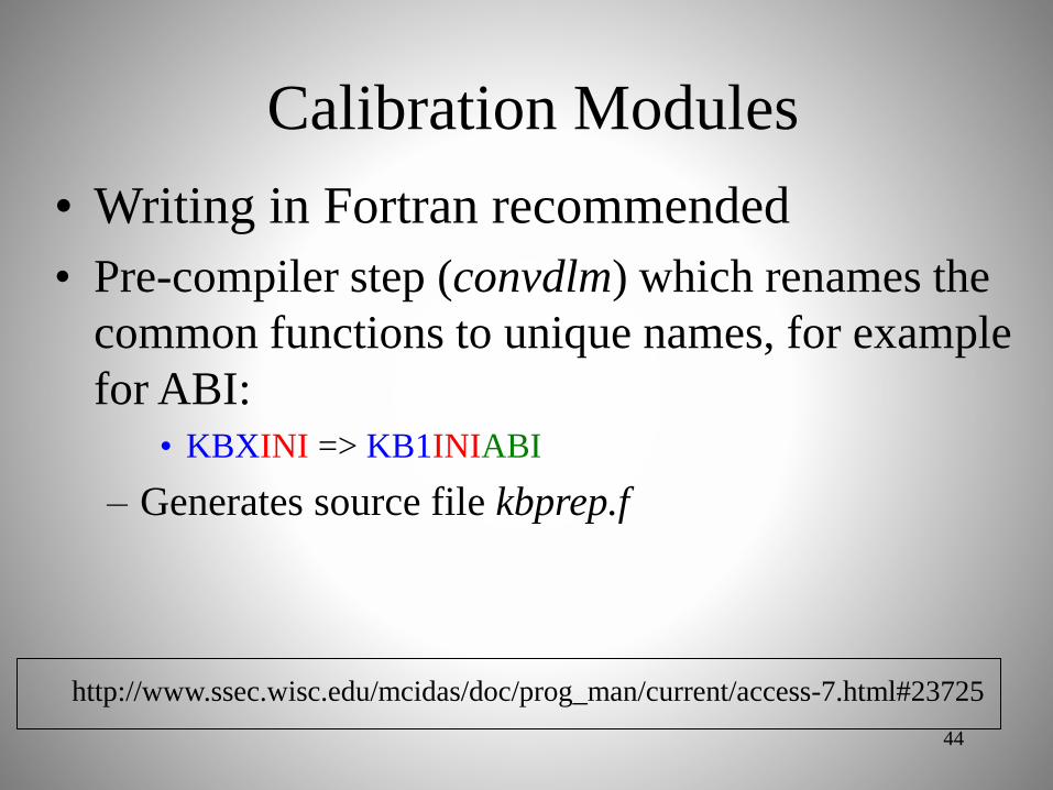
Calibration Modules
44
• Writing in Fortran recommended
• Pre-compiler step (convdlm) which renames the
common functions to unique names, for example
for ABI:• KBXINI => KB1INIABI
– Generates source file kbprep.f
http://www.ssec.wisc.edu/mcidas/doc/prog_man/current/access-7.html#23725

ADDE Server Breakdown
Russ Dengel and Dave Santek
Space Science and Engineering Center
2016 McIDAS Users’ Group Meeting
Madison,WI
14 November 2016
45

Goals of Course
• How to approach building an
ADDE server– Converter vs. ADDE server
– Data format issues
– Navigation decisions
– Calibration decisions
– ADDE required features
• This course addresses only ‘image’ data
46

Where to begin?
47

Why write an ADDE server?
• Incorporate a new data type into McIDAS
– Reads the native file format
– No need to convert all your data into Area
files, the conversion is done on-the-fly
– Easy to provide the ADDE server to someone
hosting the data for McIDAS users
• Disadvantage:
– More difficult than a converter, because of the
ADDE features and functionality
48

What about converters?
• IMGMAKE (-XRD)
– Convert raster files (along with
latitude/longitude arrays) to McIDAS Area
files.
– Supports:
• Multi-band data
• 1- or 2-byte data
• TIFF and ENVI input
• LUT for 1-byte calibration; PRD calibration
• McIDAS-X geographic projections, polar (TBUS)49

What about converters?
• TXT2MD (Core)
– Convert point data in a text file to McIDAS
MD format
50

Writing an ADDE server
• First, know your data:
– File format API
– How the data are geolocated (navigated)
– How the stored values are converted to useful
units
• Essentially, you need the knowledge to reshape
the data into a McIDAS Area file
• All of the above are also required to write a
‘converter’
51

Data issues
• Are the files in a format using libraries already
included in McIDAS-X?
– netCDF, HDF-4, HDF-5
• If so, it’s advisable to use an existing ADDE
server as a model for the new one
• If not, still consider using an existing server as a
template for the structure of the server
• If the data are not in a raster form, an ADDE
image server may not appropriate
52

Navigation decisions
• Are the data in a geographic projection
that is in the McIDAS-X library?
– Lambert conformal, Mercator, polar
stereographic, radar, rectilinear (lat/lon grid)
• If so, it’s likely that the projection
parameters are expressed differently
(except rectilinear)
– This may not be a trivial conversion
53
http://www.ssec.wisc.edu/mcidas/doc/prog_man/current/formats-13a.html

Navigation decisions
• Are latitude/longitude points included with
the data?
– If so, use the LALO navigation if there are
less than 2,000,000 points in the image or the
lat/lon points can be sampled to that amount
– See supplementary doc included with this
course (LALOBlockDoc.pdf) and the link
below
54
http://www.ssec.wisc.edu/mcidas/doc/prog_man/current/formats-13a.html#LALO

Navigation decisions
• Is the image data in a satellite swath
format?
– Are only satellite orbit and instrument
scanning information available?
– How does the data provider expect users to
determine lat/lon for data points?
– There is no generic geostationary or polar
orbiting navigation module in McIDAS-X
• TBUS, TLE, rectified geo options
55

Navigation decisions
• Example navigation modules can be found in the
McIDAS-X source directory: nvx*.dlm
56

Calibration decisions
• How are stored values converted to useful units,
for example raw counts to brightness
temperatures?
– Is it through a lookup table?
– Is there an equation?
– Are the coefficients constant for the entire image
or do they vary line-by-line?
– Is it a simple conversion with no need for high
precision?
57
http://www.ssec.wisc.edu/mcidas/doc/prog_man/current/access-7.html#23725

Calibration: Lookup table
• This is practical for tables of up to 32768 values
(16-bit unsigned integers)
• If the lookup table is larger:
– Consider fitting a polynomial to the table values, and
storing the coefficients in the calibration block
– Store the table in an external file (not recommended)
58

Calibration: Equation
• There are two ways to calculate using an
equation:
– Compute by pixel-by-pixel
– Generate lookup table to reduce the amount of
calculations
– There are many byte-level and lookup table utilities
in the McIDAS-X library (see link below)
59
http://www.ssec.wisc.edu/mcidas/doc/prog_man/current/utilities-5.html

Calibration: Constant coefficients
• Use the calibration block in Area file structure
• Store a set of coefficients for each band to
handle single and multi-band Area files
• Use scaled integers for the coefficients as
floating point numbers can get inadvertently
byte-swapped during ADDE transfers.
– Occurs when value represents valid ASCII characters
60
http://www.ssec.wisc.edu/mcidas/doc/prog_man/current/formats-1.html#16227

Calibration: Line-by-line coefficients
• Use the Calibration section in the line prefix to
store the coefficients
• Include a known value in this Calibration section
to handle big- and little-endian formatted Area
files
61
http://www.ssec.wisc.edu/mcidas/doc/prog_man/current/formats-1.html#12392
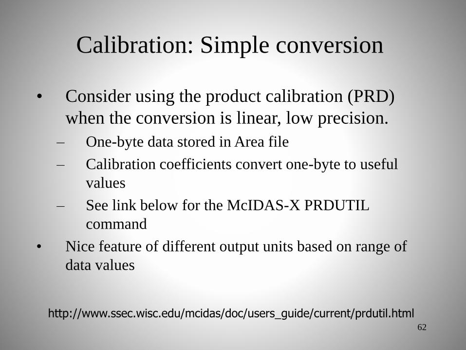
Calibration: Simple conversion
• Consider using the product calibration (PRD)
when the conversion is linear, low precision.
– One-byte data stored in Area file
– Calibration coefficients convert one-byte to useful
values
– See link below for the McIDAS-X PRDUTIL
command
• Nice feature of different output units based on range of
data values
62
http://www.ssec.wisc.edu/mcidas/doc/users_guide/current/prdutil.html
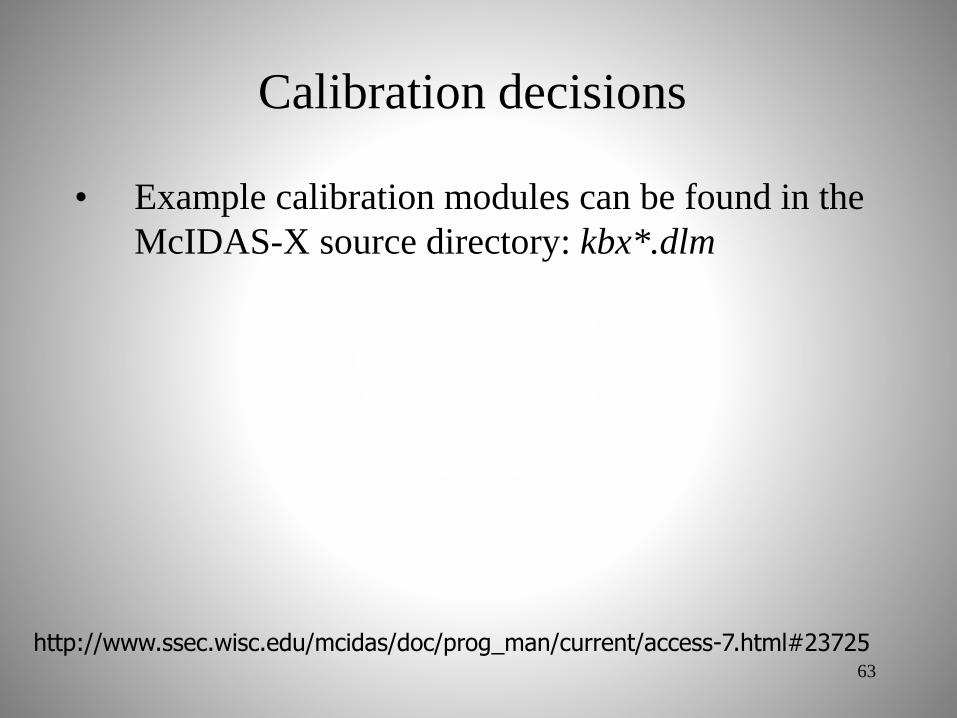
Calibration decisions
• Example calibration modules can be found in the
McIDAS-X source directory: kbx*.dlm
63
http://www.ssec.wisc.edu/mcidas/doc/prog_man/current/access-7.html#23725

Additional
• Two data files may need to be modified in the
~mcidas/data directory:
– If necessary, add a new McIDAS satellite source (SS)
to SATANNOT
– Add instrument/band list entry to SATBAND
• Check with the MUG for an SS number to use and how
to edit these files
64
http://www.ssec.wisc.edu/mcidas/doc/prog_man/current/formats-28.htmlhttp://www.ssec.wisc.edu/mcidas/doc/prog_man/current/formats-27.html

Minimum required features
• Region selection:
– Convert lat/lon to line/element
– Extract rectangle of data centered on line/element
• Construct arrays of latitude and longitude for
every nth line/element
• Send data back as 1-byte grayscale values
65

ADDE Server Steps
1. Read the ADDE client request
2. Read the server mapping table
3. Interpret the client request
4. Retrieve requested data from disk
5. Send the data to the client
6. End the transaction
66

http://www.ssec.wisc.edu/mcidas/doc/prog_man/current/servers-3.html#42191
• See section: Using a secondary server
• Call M0InitLocalServer to read client request
• This gets the request block into a C structure
1. Read the ADDE client request
67

http://www.ssec.wisc.edu/mcidas/doc/prog_man/current/servers-3.html#11020
• M0sxdatasetinfo reads RESOLV.SRV
– RESOLV.SRV is written by DSSERVE command
• Contents of RESOLV.SRV are parsed and returned
in a list of variables
– Information on the dataset (e.g. directory/file mask)
2. Read the server mapping table
68

http://www.ssec.wisc.edu/mcidas/doc/prog_man/current/servers-3.html#16284
• Retrieve parameters from the request string using
Mccmdstr, Mccmdint, etc.– These are standard McIDAS-X command line argument
fetchers
– The parameters contain size, band, center point, etc.
specifications
3. Interpret the client request
69

http://www.ssec.wisc.edu/mcidas/doc/prog_man/current/servers-5.html#25171
Image directory request syntax
http://www.ssec.wisc.edu/mcidas/doc/prog_man/current/servers-5.html#41467
Image data request syntax
70

http://www.ssec.wisc.edu/mcidas/doc/prog_man/current/servers-3.html#28039
You, the author of the server, must be familiar with
the data file format, libraries, and APIs to read the
data
4. Retrieve requested data from disk
71

http://www.ssec.wisc.edu/mcidas/doc/prog_man/current/servers-3.html#16225
• Send data to client using M0sxsend
• Data must be in big-endian format (network byte
order)
– Use swbyt4 and swbyt2 to switch bytes (no effect on
big-endian machines)
5. Send the data to the client
72
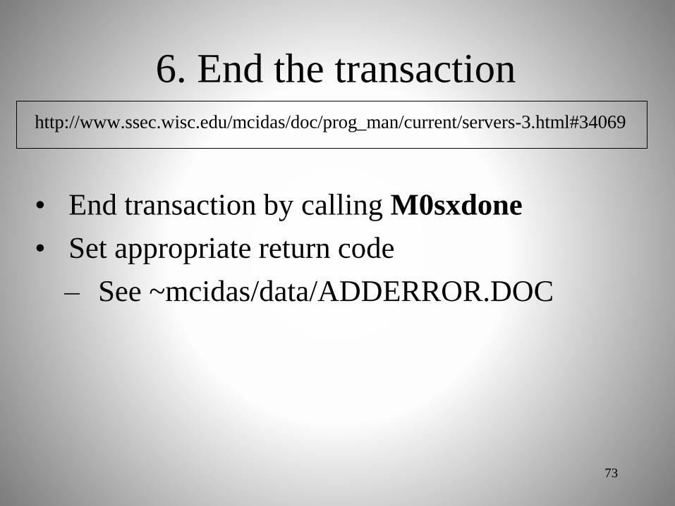
http://www.ssec.wisc.edu/mcidas/doc/prog_man/current/servers-3.html#34069
• End transaction by calling M0sxdone
• Set appropriate return code
– See ~mcidas/data/ADDERROR.DOC
6. End the transaction
73

An ADDE Directory Server
• Constructs a McIDAS directory block
• May return multiple directory blocks
• Returns
– ADDE absolute position
– Directory block
– AUX cards
74

Directory: Transaction
Parameters
• DAY: range of image dates
• TIME: range of image times
• BAND: range of image bands
• SS: range of Satellite IDs
• AUX: AUXiliary Cards
– Calibration information
– Basic geolocation information
75

Directory: Server Operations
• Process the transaction request
parameters
• Make a list of files matching the ADDE
file mask
• Decode the Day/Time info
• Time order the images
76

Directory: Server Operations
• Validate the image using request
parameters
• Extract the dimensions, lat/lon, and
datasets
• Construct the directory block
• Construct AUX cards
• Send the directory to the client
77

Directory: AUX cards
• Part of every directory transaction
• Information NOT contained in the
directory block
– Lat/Lon center point
– Lat/Lon resolution at center point
– Nominal Lat/Lon resolution
– Calibrations per band
78

Directory: General Rules
• Directory Server will return a 65 word
block (position + 64 word directory)
• DATE is stored in IYD format instead
of CYD (done for Y2K)
– IYD – yyyddd, where yyy is the number
of years since 1900
• Band Map (word 18) is a bit map of
bands contained in the source image79

Some Rules: Byte Order
• ADDE servers ONLY send big-endian
byte order
• ADDE servers are responsible for switch
from little-endian to big-endian
• Client will handle transform to native
byte order
• Some parts of the return transaction may
contain ASCII text (not switched)80

Some Rules: Resolution
• McIDAS uses a relative resolution
instead of actual resolution
• 1-based where 1 is the highest
resolution produced by the instrument
• Integer values only
• AUX cards will contain the ground
based lat/lon resolution at subpoint
81

An ADDE Data Server
• Constructs an ADDE “image object”
• Returns only 1 image
• May return multiple image bands
• Includes navigation and calibration
• Image as described by the request
82
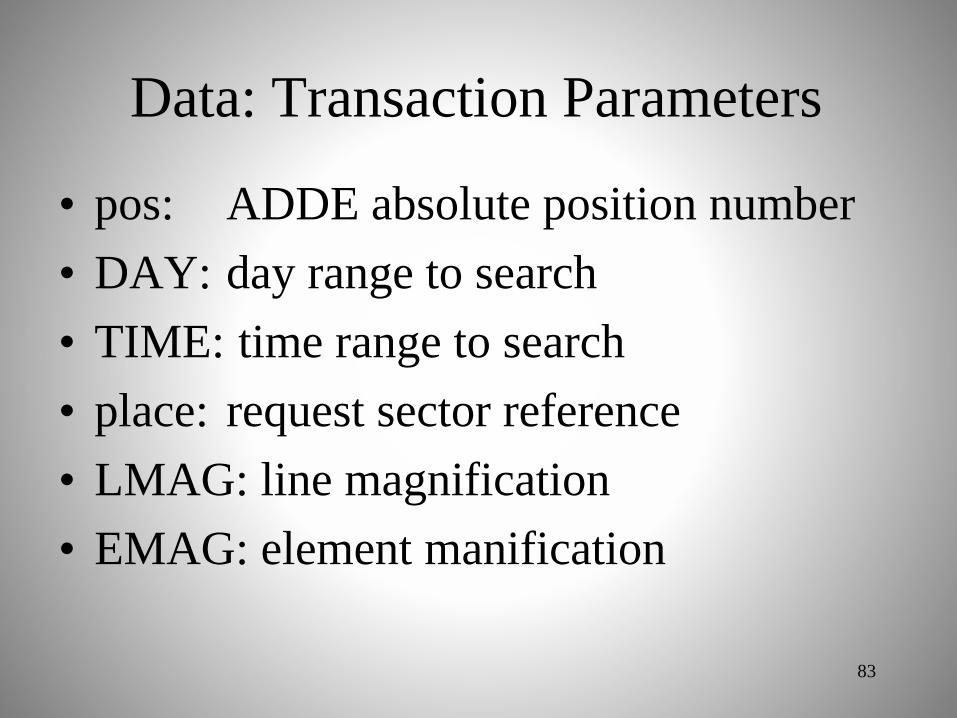
Data: Transaction Parameters
• pos: ADDE absolute position number
• DAY: day range to search
• TIME: time range to search
• place: request sector reference
• LMAG: line magnification
• EMAG: element manification
83

Data: Transaction Parameters
• size: line and element size
• BAND: requested image band(s)
• SPACE: bytes per element (1,2 or 4)
• UNIT: requested output units
84

Data: Server Operations
• Validate image based on the request
• Extract the Lat/Lon and data fields
• Subsect the data based on request coordinate
system (Earth, Image or File)
• Subsect the Lat/Lon based on the request
• Sample data to requested resolution
reduction
85

Data: General Rules
• The 4 byte law: All parts of an image
line (prefix + data) sizes must be a
multiple of 4 bytes
• Data is scaled integers only
• No negative numbers
86

Data: Calibration Rules
• RAW is the format of the data closest to
the “raw” signal (file format)
• RAD is radiance; typically 4-byte
• TEMP is Kelvin; typically 2-byte
• BRIT is brightness; always 1-byte
– GRYSCL function converts TEMP to BRIT
– There is always a BRIT calibration
87
Debugging a Server
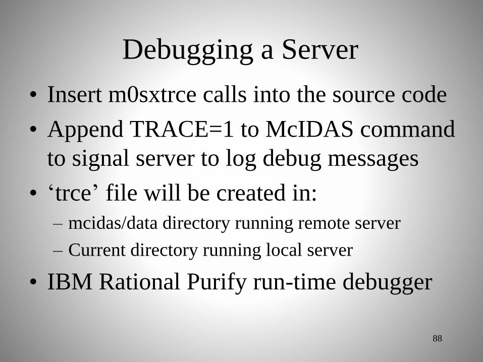
• Insert m0sxtrce calls into the source code
• Append TRACE=1 to McIDAS command
to signal server to log debug messages
• ‘trce’ file will be created in:
– mcidas/data directory running remote server
– Current directory running local server
• IBM Rational Purify run-time debugger
88

Examine Server Code
• scatadir.pdf
• scataget.pdf
• Other ADDE servers of interest
89

McIDAS-X Programming Concepts
Dave Santek, Russ Dengel, Rick Kohrs
Space Science and Engineering Center
2016 McIDAS Users’ Group Meeting
Madison, WI
14 November 2016
90

Goals of course
• To understand how to write a
McIDAS-X application
– Developer’s overview
– Structure of an application
– Summary of available functions
– Examine a basic application
91

Developer’s overview
Source file naming convention
92
http://www.ssec.wisc.edu/mcidas/doc/prog_man/current/basics-3.html
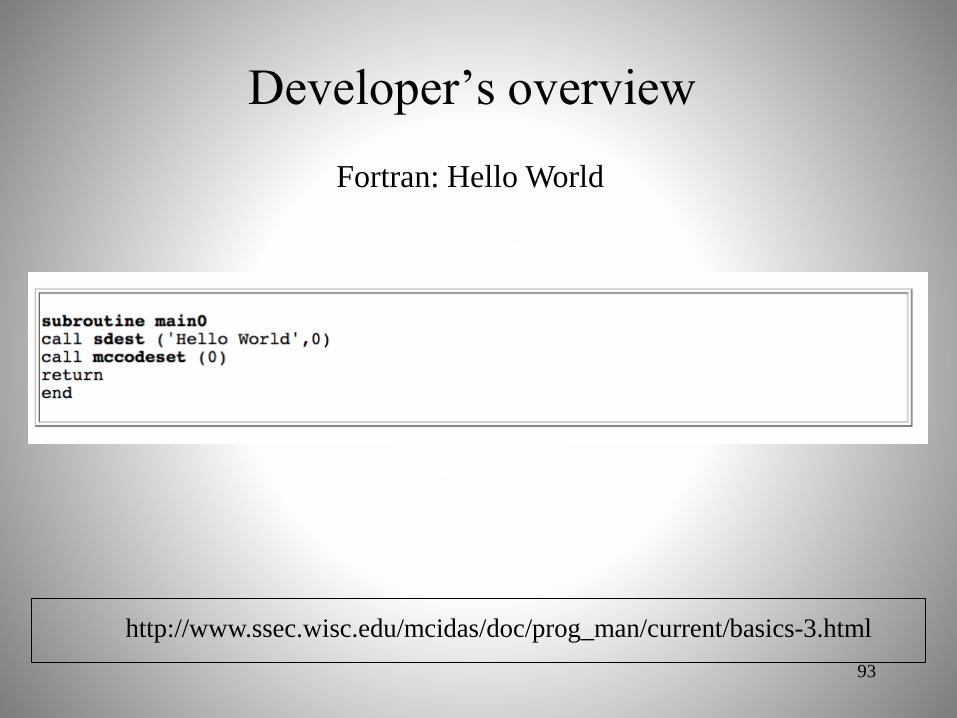
Developer’s overview
Fortran: Hello World
93
http://www.ssec.wisc.edu/mcidas/doc/prog_man/current/basics-3.html

Developer’s overview
C: Hello World
94
http://www.ssec.wisc.edu/mcidas/doc/prog_man/current/basics-3.html

Developer’s overview
Fortran: Help section
95
http://www.ssec.wisc.edu/mcidas/doc/prog_man/current/basics-3.html

Developer’s overview
C: Help section
96
http://www.ssec.wisc.edu/mcidas/doc/prog_man/current/basics-3.html

Mixed language programming
• McIDAS contains Fortran and C library
routines:– In many cases, Fortran can call C routines directly
and vice versa.
– For some routines, there are C or Fortran jackets to
make it easy (especially, when strings are being
passed)
97

Mixed language programming
98
C calling Fortran
Fortran calling Fortran

Developer’s overview
99
http://www.ssec.wisc.edu/mcidas/doc/prog_man/current/basics-3.html
• The link below has other basic
information, including:– Suggestions on debugging
– Programming do’s and don’ts

subroutine main0
implicit none
integer len_triminteger mccmdintinteger mccmddblinteger mccmdstr
C --- local variables
integer iretinteger ivaldouble precision dval character*80 cstrcharacter*80 print
Default Value
Minimum allowed Value
Maximum allowed value
Simple Fortran program
100
iret = mccmdint(' ',1,'Integer Value',15,0,9000,ival)if (iret .lt. 0) goto 2000iret = mccmddbl(' ',2,'Double Precision Value',
& 15.,0.,9000.,dval)if (iret .lt. 0) goto 2000iret = mccmdstr(' ',3,'String Value',cstr)if (iret .lt. 0) goto 2000
call sdest(' integer value is: ',ival)write(print,*) ' double value is ',dvalcall sdest(print,0)call sdest(' String value is >'//cstr//'<',0)call sdest(' String value is >'//cstr(1:len_trim(cstr))//'<',0)
2000 continuecall sdest('TEST: Done',0)

#include <string.h>#include <stdio.h>#include <stdlib.h>#include <string.h>#include "mcidas.h"#include "mcidasp.h"#include "m0arg.h"
int main (int argc, char **argv) {
int ok;int length;double dlength;const char * cstr;
/* initialize mcidas environment */ok = Mcinit (argc, argv);if (ok < 0) {fprintf (stderr, "%s\n", Mciniterr ());goto End_Of_Main;
}
ok = Mccmdint(" ",1,"Test Integer Value",0,1,5,&length);if (ok < 0) goto End_Of_Main;ok = Mccmddbl(" ",2,"Test Double Value",0.,1.,0.,&dlength);if (ok < 0) goto End_Of_Main;ok = Mccmdstr(" ",3,"Test Double Value",&cstr);if (ok < 0) goto End_Of_Main;
Mcprintf("length read in as %d \n",length);Mcprintf("length read in as %f \n",dlength);Mcprintf("length read in as >%s< \n",cstr);
End_Of_Main: Mcprintf("TEST: Done\n");return(0);
}
Simple C program
101

Command line argument fetching
102
http://www.ssec.wisc.edu/mcidas/doc/prog_man/current/utilities-2.html
• mccmd* functions read in keywords and
positional parameters from the command
line
– * = str, int, dbl, iyd, ihr, dhr, ill, dll, quo
(different variable types)
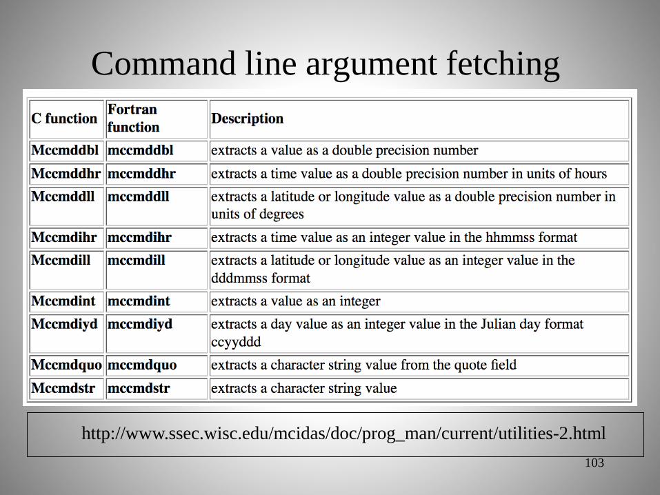
Command line argument fetching
103
http://www.ssec.wisc.edu/mcidas/doc/prog_man/current/utilities-2.html

Command line argument fetching
104
http://www.ssec.wisc.edu/mcidas/doc/prog_man/current/utilities-2.html
rc = mccmdint(‘GRA.PHICS’,1,’GRA Frame #’,
mcgetgraphicsframenumber( ),1,
maxgraframe,ifrab)
rc = mccmdint(' ',2,'Graphics Frame Number’,
mcgetgraphicsframenumber( ),1,
maxgraframe,ifrab)

User Common (UC)
105
http://www.ssec.wisc.edu/mcidas/doc/prog_man/current/utilities-4.html
• Blocks of shared memory
• Divided into 2 regions
– Positive UC is constant across session
– Negative UC is constant across application
– Documented in ~mcidas/data/UC.DOC
• Contains both system- and user-level
information

User Common (UC)
106
http://www.ssec.wisc.edu/mcidas/doc/prog_man/current/utilities-4.html

User Common (UC)
107
http://www.ssec.wisc.edu/mcidas/doc/prog_man/current/utilities-4.html

Error handling
108
http://www.ssec.wisc.edu/mcidas/doc/prog_man/current/utilities-4.html

Conversion utilities
109
http://www.ssec.wisc.edu/mcidas/doc/prog_man/current/utilities-5.html
1. Manipulating data at the byte level
2. Handling character strings
3. Converting day and time formats
4. Converting latitude and longitude formats
5. Converting physical units such as speed and
temperature
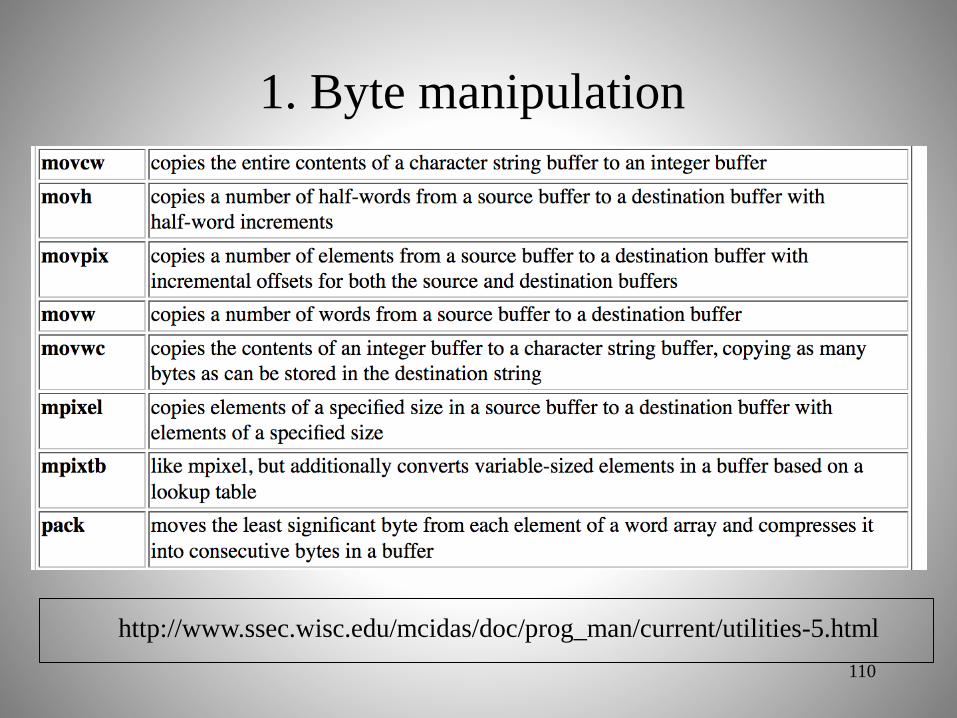
1. Byte manipulation
110
http://www.ssec.wisc.edu/mcidas/doc/prog_man/current/utilities-5.html

2. Character strings
111
http://www.ssec.wisc.edu/mcidas/doc/prog_man/current/utilities-5.html

3. Day and time conversions
112
http://www.ssec.wisc.edu/mcidas/doc/prog_man/current/utilities-5.html

4. Latitude/Longitude conversions
113
http://www.ssec.wisc.edu/mcidas/doc/prog_man/current/utilities-5.html
• flalo: converts an integer representation of
latitude or longitude in the format dddmmss
to a single-precision float, in degrees
• ilalo: converts a single-precision latitude or
longitude to an integer value in the format
dddmmss
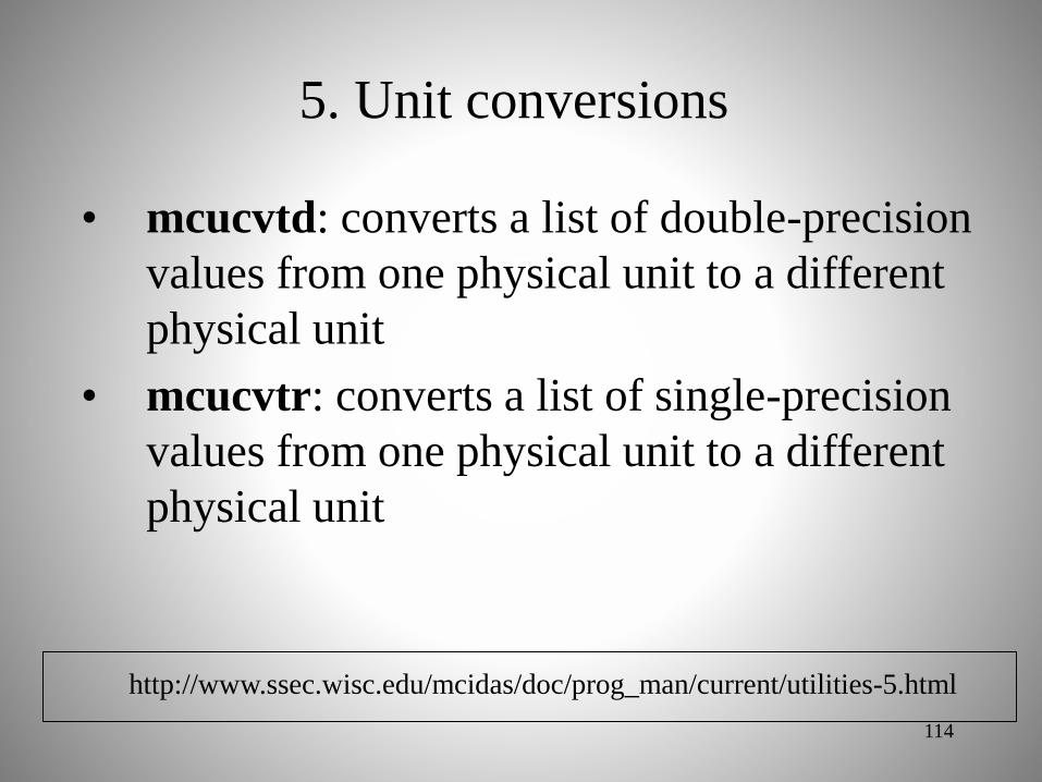
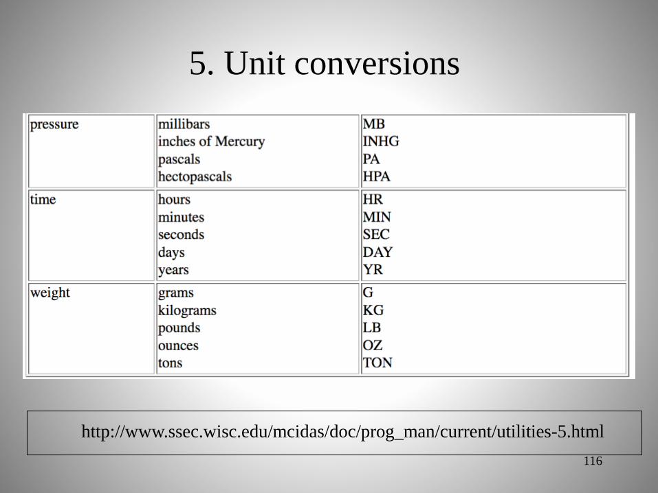
5. Unit conversions
114
http://www.ssec.wisc.edu/mcidas/doc/prog_man/current/utilities-5.html
• mcucvtd: converts a list of double-precision
values from one physical unit to a different
physical unit
• mcucvtr: converts a list of single-precision
values from one physical unit to a different
physical unit

5. Unit conversions
115
http://www.ssec.wisc.edu/mcidas/doc/prog_man/current/utilities-5.html
5. Unit conversions
116
http://www.ssec.wisc.edu/mcidas/doc/prog_man/current/utilities-5.html

Science utilities
117
http://www.ssec.wisc.edu/mcidas/doc/prog_man/current/utilities-6.html

Science utilities
118
http://www.ssec.wisc.edu/mcidas/doc/prog_man/current/utilities-6.html

Text output
119
http://www.ssec.wisc.edu/mcidas/doc/prog_man/current/utilities-3.html
• C and Fortran routines

Text output
120
http://www.ssec.wisc.edu/mcidas/doc/prog_man/current/utilities-3.html
• sdest - standard messages

Text output
121
http://www.ssec.wisc.edu/mcidas/doc/prog_man/current/utilities-3.html
• edest - error messages
– Output text appears yellow in text window

Text output
122
http://www.ssec.wisc.edu/mcidas/doc/prog_man/current/utilities-3.html
• ddest - debug messages
– Only output with DEV=CCC on command line

Drawing graphics
123
http://www.ssec.wisc.edu/mcidas/doc/prog_man/current/utilities-3.html

Drawing graphics: Example
124
http://www.ssec.wisc.edu/mcidas/doc/prog_man/current/utilities-3.html
Set variables to the box corners, in screen coordinates

Drawing graphics: Example
125
http://www.ssec.wisc.edu/mcidas/doc/prog_man/current/utilities-3.html
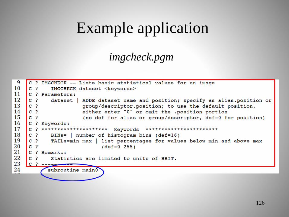
Example application
126
imgcheck.pgm

Parameter fetching
127
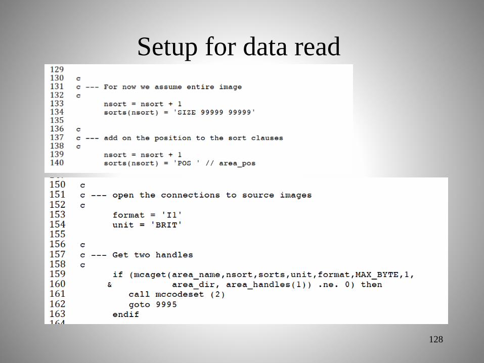
Setup for data read
128

Read data
129

Operate on data
130
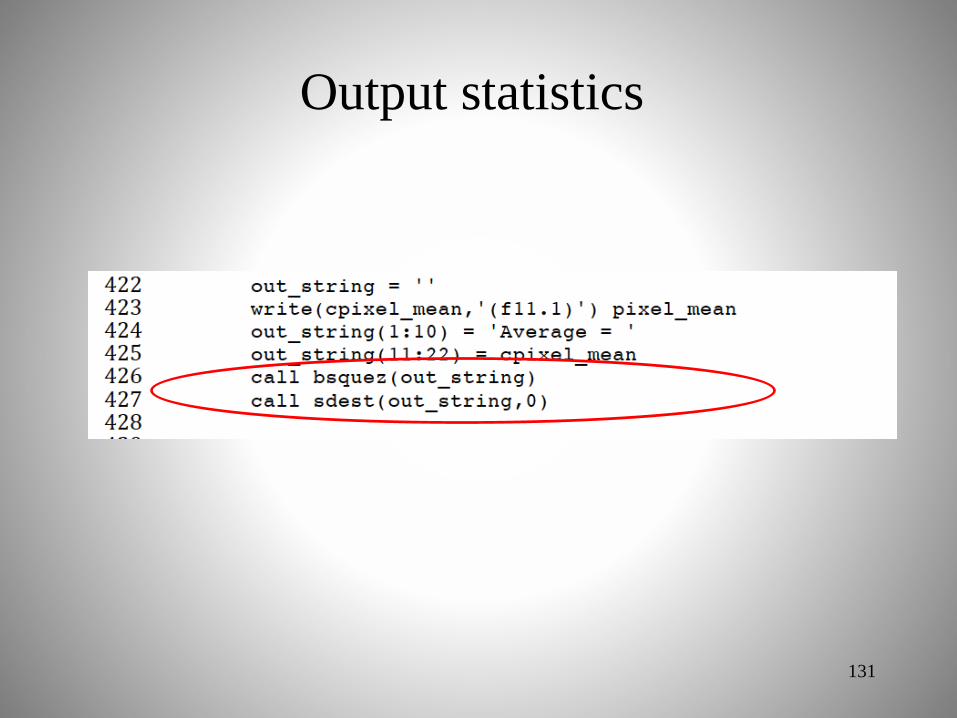
Output statistics
131

Any questions or other topics?
132