addendum to the escondido research and … to the escondido research and technology center specific...
TRANSCRIPT

ADDENDUM
to the
ESCONDIDO RESEARCH AND TECHNOLOGY CENTER SPECIFIC PLAN
FINAL ENVIRONMENTAL IMPACT REPORT
for the proposed
ERTC Specific Plan Amendment, City of Escondido General Plan Amendment
and Hospital/Medical Campus
Palomar Pomerado Healthcare District 15255 Innovation Drive
San Diego, CA 92128
December 6, 2005


ERTC Specific Plan i December 6, 2005 FEIR Addendum
TABLE OF CONTENTS
Section Page I. INTRODUCTION............................................................................................................... 1 II. BACKGROUND DISCUSSION........................................................................................ 3
Palomar Medical Center ..................................................................................................... 3
Potential Hospital Sites ....................................................................................................... 3
ERTC Specific Plan Amendment ....................................................................................... 4 III. PROJECT DESCRIPTION................................................................................................. 5
General Plan Amendment ................................................................................................... 5
Specific Plan Amendment................................................................................................... 5
New Hospital/Medical Campus .......................................................................................... 7 IV. ENVIRONMENTAL ISSUES.......................................................................................... 13
A. Land Use and Planning ......................................................................................... 13
B. Transportation/Circulation.................................................................................... 17
C. Air Quality ............................................................................................................ 21
D. Noise ..................................................................................................................... 24
E. Hazards ................................................................................................................. 27
F. Biological Resources............................................................................................. 32
G. Aesthetics.............................................................................................................. 34
H. Water Quality........................................................................................................ 38
I. Public Services and Utilities ................................................................................. 40
J. Cultural Resources ................................................................................................ 44
K. Geologic Hazards.................................................................................................. 46 V. DOCUMENT AVAILABILITY....................................................................................... 49 VI. REFERENCES ................................................................................................................. 51

ERTC Specific Plan ii December 6, 2005 FEIR Addendum
Figures Page Figure 1 Regional Location Map................................................................................... 53
Figure 2 Proposed Specific Planning Areas .................................................................. 54
Figure 3 Proposed Hospital/Medical Campus Location................................................ 55
Figure 4 Proposed Hospital/Medical Campus Concept Plan ........................................ 56
Figure 5 Conceptual Hospital/Medical Campus Landscape Plan ................................. 57
Figure 6 Proposed Helicopter Flight Paths.................................................................... 58 Attachments Attachment 1: Mitigation Monitoring and Reporting Program
Attachment 2: Traffic Impact Analysis (LLG 2005)
Attachment 3: Air Quality Technical Report (SRA 2005)
Attachment 4: Noise Technical Report (PMC 2005)

ERTC Specific Plan 1 December 6, 2005 FEIR Addendum
I. INTRODUCTION This Addendum to the Final Environmental Impact Report (FEIR) for the Escondido Research and Technology Center (ERTC), SCH No. 2001121065, has been prepared for Palomar Pomerado Healthcare District (PPH) in accordance with the California Environmental Quality Act (CEQA) Guidelines Section 15164. It updates the FEIR that was prepared for the City of Escondido (City) and certified in November 2003. The FEIR is available for review at the City of Escondido Planning Department, which is located at 201 North Broadway, Escondido, CA 92025. The primary purpose of the Addendum is to evaluate the potential environmental effects of proposed modifications to the ERTC Specific Plan and construction of a new hospital/medical campus. A Specific Plan Amendment (SPA) would be approved to implement the proposed changes, which include increasing the total acreage of Planning Area 4 and reducing the total acreage of Planning Area 5. In addition, the SPA identifies hospital/medical facilities as an allowable use in Planning Area 4. The FEIR included an evaluation of the potential impacts of development of an industrial business park on Planning Areas 4 and 5. A General Plan Amendment (GPA) may also be approved, if required by the City of Escondido, which would include hospital/medical facilities as an allowable use in the ERTC Specific Planning Area. This Addendum is intended to evaluate the potential impacts of development of a hospital/medical campus on Planning Area 4 of the SPA to determine if the changes and additional detail beyond that analyzed in the FEIR meet any of the requirements for the preparation of a Subsequent or Supplemental EIR per Sections 15162-15163 of the State CEQA Guidelines. This section of the CEQA Guidelines would require a Subsequent or Supplemental EIR if any of the following conditions apply:
• Substantial changes are proposed in the project which will require major revisions of the previous EIR due to the involvement of new significant environmental effects or a substantial increase in the severity of previously identified significant effects;
• Substantial changes occur with respect to the circumstances under which the project is
undertaken which will require major revisions of the previous EIR due to the involvement of new significant environmental effects or a substantial increase in the severity of previously identified significant effects; or
• New information of substantial importance, which was not known and could not have been
known with the exercise of reasonable diligence at the time the previous EIR was certified as complete, shows any of the following:
o The project will have one or more significant effects not discussed in the previous
EIR;
o Significant effects previously examined will be substantially more severe than shown in the previous EIR;

ERTC Specific Plan 2 December 6, 2005 FEIR Addendum
o Mitigation measures or alternatives previously found not to be feasible would in fact be feasible, and would substantially reduce one or more significant effects of the project, but the project proponents decline to adopt the mitigation measure or alternative; or
o Mitigation measures or alternatives which are considerably different from those analyzed in the previous EIR would substantially reduce one or more significant effects on the environment, but the project proponents decline to adopt the mitigation measure or alternative.
Section 15164 of the State CEQA Guidelines states that an Addendum to an EIR may be prepared “if some changes or additions are necessary, but none of the conditions described in Section 15162 calling for preparation of a subsequent EIR have occurred.” If none of the aforementioned conditions are met, a subsequent or supplemental EIR is not required. Rather, an agency can:
• Decide that no further environmental documentation is necessary; or • Require that an addendum be prepared.
Since some changes are proposed in the ERTC SPA, including the reconfiguration of Planning Areas 4 and 5 and a change in allowable land uses on Planning Area 4, PPH has decided to prepare an addendum to the FEIR.

ERTC Specific Plan 3 December 6, 2005 FEIR Addendum
II. BACKGROUND DISCUSSION In 2002, the FEIR analyzed the environmental impacts of the proposed ERTC Specific Plan, set forth mitigation measures, and was certified. At the time of FEIR certification, Planning Areas 4 and 5 were anticipated to be developed as an industrial business park. Since that time, the site has undergone rough grading consistent with the ERTC EIR. However, no industrial business park has been constructed on Planning Areas 4 and 5 and the site remains undeveloped. PALOMAR MEDICAL CENTER
PPH has prepared a Facilities Master Plan that proposes repair, replacement and expansion projects for both Palomar Medical Center in Escondido and Pomerado Hospital in Poway, as well as the development of outpatient satellite centers in communities throughout the District, in order to improve access to local healthcare services and meet projected future demands. One objective of the Facilities Master Plan is to improve and expand the total combined number of patient beds in all the PPH hospital facilities by approximately 70 percent. This increase is based on projected future demand for hospital beds at PPH facilities. Expansions or improvements to Pomerado Hospital and satellite facilities are subject to separate CEQA review and are not covered in this Addendum. The existing Palomar Medical Center requires a substantial expansion in order to meet the goals of the Facilities Master Plan. Currently, the need to admit patients of specific types or acuities at Palomar Medical Center often exceeds bed availability. Necessary improvements include the provision of additional hospital beds and expanded inpatient and outpatient services. Palomar Medical Center also requires structural improvements, including compliance with current State-required seismic standards for hospitals. The required structural improvements are so intensive that it would not be fiscally prudent to complete these activities while maintaining critical hospital functions. Therefore, the option to construct a replacement hospital at a new location was selected, rather than to structurally improve and expand the existing hospital. POTENTIAL HOSPITAL SITES
A wide range of possible locations were considered for the development of a new hospital to replace the existing Palomar Medical Center. PPH worked with City staff and elected officials to find a suitable site. The PPH Board signed a resolution stating that it is preferable to keep the location of the new hospital within the City of Escondido. A site size of approximately 40 acres was targeted as the ideal site size for the new hospital. A list of the potential site locations considered and the reasons why they were/were not selected is provided below. Site 1 (Old K-Mart site). This site is located at the intersection of Centre City Parkway and West Mission Avenue. The site size of 28 acres was considered to be too small for the construction of a new hospital/medical campus. Development of the hospital at this site would require the acquisition of the Albertson's across street in addition to the K-mart site. The offer was entered into separate escrow and sold before PPH had completed all planning efforts.

ERTC Specific Plan 4 December 6, 2005 FEIR Addendum
Site 2 (El Norte Parkway site). This site is located near I-15 and El Norte Parkway. This site was approximately 51 acres, which would be adequate for a new hospital/medical campus. It was rejected because it would require condemnation of over 40 residences and businesses. Site 3 (Escondido Research and Technology Center). This is the proposed project site. The site was selected because it is close to the 40 acre goal, includes grading and infrastructure, and has good freeway access. Site 4. This site is located between Gamble Lane and Hamilton Lane. The site is approximately 20 acres, which does not meet the 40 acre goal. In addition, it was rejected because it is a super fund site and would require substantial hazardous materials clean up effort. Site 5. This site is located at Felicita Road and I-15 and is approximately 14 acres in size. It was rejected because it was too small and purchased by private developer. Site 6 (San Marcos site). This site is located in the City of San Marcos near SR-78 and Twin Oaks Valley Road. This site is approximately 184 acres. PPH considered this site; however, there were issues with infrastructure and land acquisition. The site was ultimately rejected because PPH would prefer to keep the hospital in Escondido. The City of San Marcos is currently pursuing other development plans for the site. Site 7 (Mountain Meadows Road site). This site is located near I-15/Mountain Meadow Road/Deer Springs Road. This site was rejected because infrastructure would be cost prohibitive, it would require a change in zoning, is within the jurisdiction of the County of San Diego, and is far from police services. ERTC SPECIFIC PLAN AMENDMENT
The construction of a hospital on Planning Areas 4 and 5 of the ERTC Specific Plan would require amendments to the existing ERTC Specific Plan and the City’s General Plan to include a hospital/medical campus as an allowable use in these areas. Therefore, a new environmental analysis is being prepared to determine whether the change in designated land use at this location would result in any new or substantially more severe environmental impacts than those impacts identified by the FEIR.

ERTC Specific Plan 5 December 6, 2005 FEIR Addendum
III. PROJECT DESCRIPTION The “proposed project” for the purposes of this Addendum is the implementation of an SPA to the existing ERTC Specific Plan, the possible implementation of a GPA to the existing City of Escondido General Plan (if required by the City) and the construction of a new hospital/medical campus consistent with the SPA and possible GPA. The new hospital/medical campus may be referred to as Palomar Medical Center West. The project is located in the City of Escondido, California (Figure 1). GENERAL PLAN AMENDMENT
The City of Escondido may require that a GPA be approved as part of the proposed project. The GPA would revise Chapter VIII, Specific Planning Areas, to include hospital/medical facilities as an allowable use in Specific Planning Area 8, Harmony Grove Specific Plan Area. SPECIFIC PLAN AMENDMENT
The focus of the Specific Plan Amendment is to include hospital/medical, and medical research and education uses as allowable land uses in the ERTC Specific Planning Area. Specifically, the ERTC SPA accomplishes the following:
• Increases the total acreage of Planning Area 4 from 17.37 acres to 35.4 acres and increases the total building area allowed in Planning Area 4.
• Reduces the total acreage of Planning Area 5 from 22.6 acres to 4.8 acres and decreases the
total building area allowed in Planning Area 5.
• Identifies hospitals and medical clinics as allowable land uses in Planning Area 4, including, but not limited to, the following:
o Long and short-term medical care including outpatient surgery centers, imaging
centers, mental health clinics, outpatient clinics, rehabilitation clinics
o Doctor’s offices
o Emergency treatments
o Medical-related research and education facilities
o Medical, dental and optical laboratories
o Pharmacies
o Ambulance and paramedic services
o Medical-related helicopter services
o Parking lots and parking structures

ERTC Specific Plan 6 December 6, 2005 FEIR Addendum
o Pole, roof and building-mounted facilities that incorporate stealth designs or are screened from public view
o Central power plant to support primary uses
o Ancillary support services including food services, storage, and other uses incidental to the primary use
o Other uses the Community Development Director determines to be similar in nature
• Revises the ERTC Design Policies so that the architectural style of the hospital and medical uses in Planning Area 4 may vary from the industrial buildings in the other planning areas. However, all development in the ERTC shall be designed in a manner that creates a visually coherent and functional environment.
• Establishes unique Architectural Design Guidelines for Planning Area 4, which allows it to
differentiate itself as a unique but cohesive parcel in the ERTC. Design guidelines for the following elements have been established:
o Character
o Facades
o Fenestration and Curtain Wall
o Structure
o Roof Forms
o Mechanical Equipment
o Building Entrances
o Materials
o Colors and Finishes
o Design Details
o Rear Elevations
• Establishes specific landscape guidelines for Planning Area 4 which allows for a more native and naturalized plant palette.
• Identifies specific lighting requirements for the hospital and heliport uses in Planning Area 4,
including perimeter lighting at the deck, a beacon, obstruction lights, and a lighted windcone. Requires that all heliport lighting shall be designed in a manner to avoid unnecessary glare or spillover onto adjacent properties to the fullest extent possible.
• Establishes environmental regulations for Planning Area 4 associated with medical waste
storage/disposal and helicopter traffic.

ERTC Specific Plan 7 December 6, 2005 FEIR Addendum
• Establishes the following parking ratios for hospital and medical uses:
o Hospital Inpatient: 1.25 spaces per patient bed.
o Hospital Outpatient Facility: 5 spaces per 1,000 square-feet of gross floor area.
o Laboratory and Food Service: 1 space per 575 square-feet of gross floor area.
o Central Service Warehouse: 1 space per 800 square-feet. The revisions to the Specific Plan would be in conformance with applicable State law and the City General Plan, as identified in Section IV of the SPA. All other aspects of the ERTC Specific Plan would remain unchanged. NEW HOSPITAL/MEDICAL CAMPUS
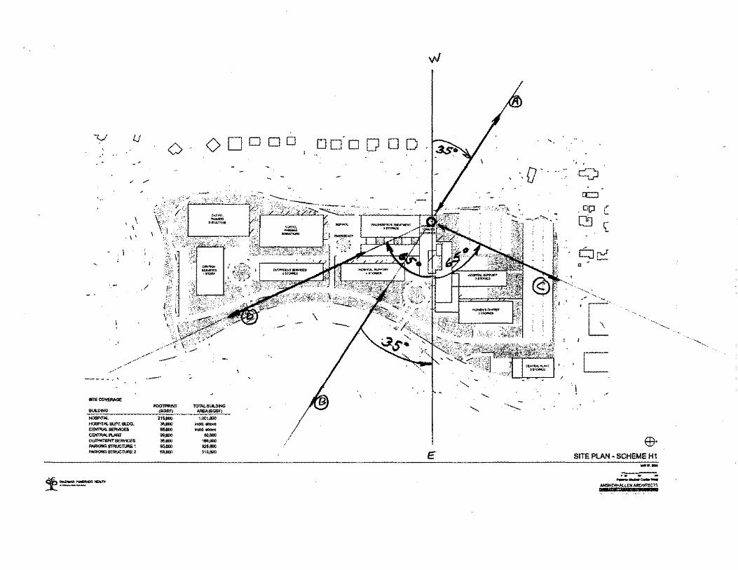
Location The proposed hospital/medical campus would be constructed on Planning Area 4 of the proposed ERTC SPA (Figure 2). The new hospital/medical campus is sometimes referred to as Palomar Medical Center West. The approximately 35-acre project site is located along the western side of Citracado Parkway, south of Vineyard Drive, in the western portion of the City of Escondido (Figure 3). The property is currently vacant and has been cleared of vegetation and undergone preliminary grading. Proposed Buildings and Services Planning Area 4 would be developed into a hospital/medical campus with approximately 1.2 million gross square feet (GFS) of building space. Figure 4 identifies the proposed hospital/medical campus concept plan. The project would construct a new 453-bed hospital, with approximately 360 beds provided for general inpatient services and the remaining 93 beds provided as part of a women’s center. The hospital building would have several wings with varying numbers of floors and would be generally located in the north-central portion of the proposed hospital/medical campus. Two, 10-to-12-story nursing towers would be located in the central portion of the hospital providing 314,000 gsf of building space for the 360 inpatient beds. Diagnostic and treatment services would be provided in a 228,000 gsf hospital wing in the southwestern portion of the hospital. The diagnostic and treatment services wing would include emergency services, imaging, surgery, an outpatient diagnostic center, and hospital support services. The women’s center would be located in the northeastern hospital wing of the hospital building, providing a total of 110,000 gsf of building space. The women’s center would offer the following services: labor and delivery, neonatal intensive care unit (NICU), post partum, and an outpatient center. A separate central services building would provide approximately 91,000 gsf of building space for a reference lab, a warehouse, information technology/information systems (IT/IS), and food services. The central services building would be two stories in height and would be located in the southern portion of the hospital campus.

ERTC Specific Plan 8 December 6, 2005 FEIR Addendum
Hospital support would be provided in a four-to-eight story attached building and would include support services, administrative services, a conference center, and outpatient services. The hospital support building would be connected to the southeastern wing of the hospital building. In addition, a separate outpatient services building would be constructed in the central portion of the hospital campus. This building would provide approximately 160,000 gsf of building space in four-to-eight stories. Finally, a 50,000 gsf central plant would be constructed in the northeastern corner of the site. This building would be three stories in height. As a project design feature, a noise study will be prepared to the final design of the central plant facility to ensure that necessary noise abatement measures are incorporated into the building plans to attenuate the equipment noise to comply with the applicable City noise ordinance criteria at the property lines. Site Access The project site would be accessed from five driveways located off Citracado Parkway. All driveways would connect to the central loop road generally located at the perimeter of the hospital/medical campus. For purposes of this discussion, the entrance driveways are referred to as Driveways A-E, as depicted on Figure 4. Driveway A would be the southernmost driveway and would provide access to the central loop road, the central services building, the southern surface parking lot and the southernmost parking structure. Driveway B would have separated entrance and exit drives and would connect to a drop-off circle near the outpatient services building. This driveway would also access the southern parking structure. Driveway C would provide direct access to the emergency department drop-off area and the northern five-level parking structure. Driveway D would have separated entrance and exit drives and would connect to the drop-off circle near the eastern nursing tower and the hospital support building. Finally, Driveway E would provide access to the central plant and the surface parking lot located at the northern portion of the hospital/medical campus. Parking A mixture of surface and garage parking spaces would be provided in the northern, southwestern and southern portions of the hospital/medical campus. A total of 2,595 parking spaces would be provided onsite. A large surface parking lot would be located along the northern and northwestern site boundaries and a smaller surface lot would be located in the southern portion of the site. Both would connect to the central loop road. In addition, two five-story parking structures would be located in the southwestern portion of the site, also connecting to the central loop road. Proposed Landscape Plan The hospital/medical campus would provide landscaping consistent with the landscape design guidelines identified in the ERTC SPA for Planning Area 4. A proposed landscape concept plan is provided in Figure 5.

ERTC Specific Plan 9 December 6, 2005 FEIR Addendum
Helipad Location and Approvals. A helipad would be constructed onsite for helicopters transporting trauma patients. The preferred location for the helipad is on the roof of the western nursing tower in the northwestern portion of the hospital campus. The helipad would require the issuance of an “airspace determination” letter from the FAA, as required by Part 157 of the Federal Aviation Regulations. The project would also require review by the Airport Land Use Commission, which is the San Diego Regional Airport Authority (SDRAA). The project would also require the issuance of two permits by Caltrans Division of Aeronautics (DOA). The DOA would issue a Heliport Site Approval Permit after all approvals from other agencies have been issued, and a Heliport Permit to authorize flight operations upon post-construction inspection. Operations. The helipad would be available for helicopter use 24 hours a day. The existing Palomar Medical Center averaged approximately 23 helicopter trips per month from January through June 2005 (personal communication, Cheryl Graydon, PPH, August 1, 2005). Since the proposed hospital/medical campus would replace the existing hospital as the regional center for trauma patients, it is anticipated that the operations at the proposed hospital/medical campus would be similar to those at the existing Palomar Medical Center. Flight Paths. The flight paths proposed to serve the helipad are identified in Figure 6. Flight Path B would be the preferred approach path and is anticipated to be used for approximately 70 percent of all helicopter trips. This approach path would be from the southwest and located entirely over industrial and commercial uses west of the I-15 corridor. Paths A, C, and D would provide alternate routes that would be used if wind conditions would not allow helicopters to approach from Path B. Each of these alternate routes would be used for approximately 10 percent of all helicopter approach trips. The Flight Path A approach would be from the northwest, the Flight Path C approach would be from the north east and the Flight Path D approach would be from the southeast. Flight Path A is the preferred departure path and is anticipated to be used for approximately 70 percent of all helicopter departure trips. This path is 180 degrees from Flight Path B and would depart in the same direction (northwest) as Flight Path B would arrive. The Flight Path A alignment would be located mostly over industrial areas. The remaining Paths B, C, and D would provide alternative routes to accommodate varying wind conditions. Each alternative route would be used for approximately 10 percent of all helicopter departure trips. In order to receive approvals from the FAA and Caltrans Aeronautics, the proposed helicopter flight paths would be required to comply with standard obstruction clearance regulations including glide slopes. Offsite Improvements The proposed hospital/medical campus would include offsite traffic improvements to four City intersections and interchanges. PPH would make fair share contributions into specific City intersection improvement funds for each of the following project improvements.

ERTC Specific Plan 10 December 6, 2005 FEIR Addendum
• Restriping the eastbound approach on West 9th Street at Auto Park Way to provide a right-
turn lane, a shared through/right lane, and a left-turn lane and the provision of right-turn overlap phasing on the eastbound approach.
• Future improvements of the Valley Parkway/I-15 interchange to increase interchange capacity.
• Improvement of the Nordahl Road/SR-78 westbound ramps intersection and Nordahl Road/SR-78 ramp meter. A joint City/Caltrans Project Study Report (PSR) is on-going at the interchange. The development agreement between PPH and the City of Escondido would require the City to complete the improvements prior to operation of the hospital/medical campus.
• Signalization of the Harmony Grove Road/Howard Avenue intersection with dedicated left-turn lanes.
Project Construction Phasing. The proposed hospital campus would be constructed in four phases. Some phases of construction would be sequential, while others would overlap or occur concurrently. Construction is anticipated to begin in 2006. Phase I would include site preparation, utilities construction and any additional grading work. This phase would last for approximately one year, beginning in mid-2006 and finishing in mid-2007. Phase 2 would include construction of the central plant, central services and the hospital support building. This phase would last for approximately three years from mid-2007 to mid-2010. Construction of the central plant and central facilities buildings would each last approximately 18 months. Construction of the hospital support building would last approximately 30 months. Phase 3 would include construction of the hospital building. This phase is anticipated to last approximately 42 months, beginning in early 2008 and finishing in mid-2011. Phase 4 would include construction of the two parking structures and the outpatient services building. The parking structures would each take approximately 12 months to construct and the outpatient services building would take approximately 24 months to construct. The timing of construction has not been determined for this phase. Earthwork. Construction of the proposed hospital/medical campus would require excavation of soils for the construction of building footings and the hospital basement. Excavation depths would range from four to 22 feet below grade. The total amount of excavation, excluding site access and circulation roadways, would be approximately 200,000 cubic yards (CY). The majority of excavated materials would be reused onsite. However, some bedrock materials may require export offsite by a licensed commercial hauler in conformance with applicable laws and regulations.

ERTC Specific Plan 11 December 6, 2005 FEIR Addendum
Dust Control. Dust control measures would be incorporated into the project to reduce fugitive dust emissions during excavation and grading activities. The following best management practices (BMPs) would be implemented during construction:
• Multiple applications of water during grading between dozer/scraper passes
• Paving, chip sealing or chemical stabilization of internal roadways after completion of grading
• Use of sweepers or water trucks to remove “track-out” at any point of public street access
• Termination of grading if winds exceed 25 mph
• Stabilization of dirt storage piles by chemical binders, tarps, fencing or other erosion control

ERTC Specific Plan 12 December 6, 2005 FEIR Addendum
This page is intentionally left blank.

ERTC Specific Plan 13 December 6, 2005 FEIR Addendum
IV. ENVIRONMENTAL ISSUES The following pages describe environmental issues for the proposed project. Each section contains an analysis of project modifications and potential impacts resulting from the changes, if any. This analysis has been undertaken, pursuant to the provisions of CEQA and its Guidelines, to provide decision makers with a factual basis for determining whether any modifications to the project, changes in circumstances, or receipt of new information not available during preparation of the FEIR that would require additional review or preparation of a subsequent or supplemental EIR. The findings for each environmental topic area are summarized in the analyses that follow. The impacts from the proposed ERTC Specific Plan Amendment and hospital/medical campus have been evaluated under a maximum development scenario with 1.2 million gsf generating an ADT count of 17,060 trips (LLG 2005). A. LAND USE AND PLANNING
Existing Environmental Setting Please see Section 2.1 of the certified FEIR for a summary of the existing environmental setting for land use. FEIR Please see Section 5.1 of the certified FEIR for an analysis of the potential land use effects of the ERTC Specific Plan. The FEIR identifies that the proposed ERTC project is located in Specific Planning Area No. 8 of the Escondido General Plan. Specific Planning Area No. 8, known as the Harmony Grove Specific Planning Area, or Quail Hills, was anticipated to be developed into a high-quality industrial park which would expand Escondido’s industrial and employment base. The ERTC Specific Plan amends and supersedes the Quail Hills Specific Plan. The ERTC Specific Plan designates 10 planning areas, land uses, and the circulation system for the project area. The FEIR concluded that based on the current land use designation assigned to the proposed project site under the Quail Hills Specific Plan, implementation of the ERTC Specific Plan would be inconsistent with the General Plan. This would result in a significant land use impact. Mitigation incorporated into the project consists of a GPA, which ensures consistency with the City’s General Plan goals and objectives established within the Land Use Element and Circulation Element. The ERTC Specific Plan implements the General Plan, the City’s Zoning Ordinances, and provides guidelines for the development of the property. Implementation of the GPA as part of the project mitigates land use impacts to below a level of significance. When the FEIR was certified, no significant impacts were identified for conflicts with environmental plans or policies, incompatibility with existing land uses in the vicinity, impacts to agricultural resources, or disruption of an established community.

ERTC Specific Plan 14 December 6, 2005 FEIR Addendum
Proposed Project Modifications The ERTC Specific Plan modifications evaluated in this Addendum include primarily the reconfiguration of Planning Areas 4 and 5, identification of hospital/medical as an allowable land use in Planning Area 4, and new design guidelines for Planning Area 4. A General Plan amendment would also be processed which would identify hospital/medical services as an allowable use. Also analyzed in this EIR Addendum is the development of a 1.2 million gsf hospital to be constructed on Planning Area 4, which was previously designated for business park uses. As part of the project, a GPA to the City’s General Plan may be required and an SPA to the existing ERTC Specific Plan would be approved. The GPA, if deemed necessary by the City, would revise the General Plan to include hospital/medical as an allowable land use in Planning Area 8 (Quail Hills Specific Plan). The SPA would revise the ERTC Specific Plan to increase the total acreage of Planning Area 4 to approximately 35 acres and decrease the total acreage of Planning Area 5 to approximately 4 acres. The SPA would also include hospital/medical campus with helicopter operations as an allowable use in Planning Area 4 of the ERTC Specific Plan. The SPA would establish a set of unique design standards for the hospital campus while still maintaining a visually coherent and functional environment with the rest of the ERTC Planning Areas. The project would be required to be consistent with the design guidelines identified for Planning Area 4 in the SPA. Helicopter operations would be subject to all applicable federal, state and local regulations which would ensure consistency with surrounding land uses. The proposed hospital would be located on Planning Area 4, to the west of the proposed power plant. The power plant would be located on Planning Area 1 of the ERTC Specific Plan. Planning Area 3 and Citracado Parkway would separate the hospital from the power plant. The power plant would be required to comply with all applicable federal, state and local regulations regarding design, air quality, noise, and hazards impacts, which would ensure that the power plant would not result in any unique health risks or hazards. As required by law, the power plant would adopt an emergency response plan which would reduce the potential for health risks or hazards associated with an emergency situation. Due to the distance of the power plant from the hospital, noise from the power plant would not result in auditory disturbances at the hospital. In addition, the power plant would be consistent with the design guidelines identified in the ERTC Specific Plan and would not result in a visual impact to the hospital. As discussed in Section C., Air Quality, air quality at the hospital would not be impacted by the power plant. Therefore, the proposed hospital/medical campus would be compatible with the surrounding land uses within the ERTC Planning Area, including the proposed power plant. As identified in the FEIR, the project vicinity is dominated by urban development. Industrial parks and other heavily urbanized landscapes occupy the area immediately to the east of the ERTC Specific Planning area. The areas to the north and northwest are also dominated by urban land uses. Land uses to the south and southwest of the ERTC Specific Planning areas are dominated by rural development, eucalyptus groves, and fallow agricultural fields. Therefore, the proposed hospital/medical campus would be an extension of the existing urbanized area of Escondido and has located compatible uses next to existing residences and industrial areas.

ERTC Specific Plan 15 December 6, 2005 FEIR Addendum
Implementation of a GPA, if required by the City, would ensure project consistency with the City’s General Plan because it would identify hospital/medical facilities as an allowable use in Planning Area 8 (Quail Hills Specific Plan). The ERTC Specific Plan supersedes the Quail Hills Specific Plan as the land use planning document for Planning Area 8 of the General Plan. Therefore, the GPA, if required, would allow the construction of a hospital/medical campus in the ERTC Specific Plan area. The SPA would implement the General Plan, the City’s Zoning Ordinance, and provide new design guidelines for development of Planning Area 4. Design of the proposed hospital would be required to be consistent with the design guidelines identified in the SPA for Planning Areas 4. The guidelines identified in the previous ERTC Specific Plan and analyzed in the FEIR would remain in effect for the other Planning Areas. Therefore, the project would not result in a conflict with applicable plans or policies. The analysis and conclusions in the FEIR regarding effects to agricultural resources and disruption of an established community are adequate to address the proposed ERTC SPA and proposed hospital/medical campus. No impacts would occur with respect to these issues. Implementation of the GPA, if required by the City, an SPA and construction of a new hospital/medical campus on Planning Area 4 of the ERTC Specific Plan would not result in increased potential impacts from land use and planning above those anticipated in the FEIR. Therefore, the proposed ERTC Specific Plan modifications and proposed new hospital/medical campus are consistent with the FEIR. Findings The proposed project is consistent with the certified FEIR and will not result in any new significant plan conformance and land use compatibility impacts. Therefore, the comparison of anticipated plan conformance and land use compatibility effects of the proposed project with the impacts disclosed in the previous certified EIR support the required CEQA findings summarized below. Specifically, none of the conditions defined in Sections 15162 and 15163 of the State CEQA Guidelines that would require preparation of a subsequent or supplemental EIR have been met. Major Revisions Not Required. The ERTC Specific Plan Amendment and proposed hospital/medical campus will not result in any new significant plan conformance and land use compatibility impacts, nor is there substantial increase in the severity of impacts from that described in the certified FEIR. No Substantial Change in Circumstances Requiring Major EIR Revisions. There is no substantial evidence in the record or otherwise to indicate that there are substantial changes in the circumstances under which the land use analysis was undertaken for the ERTC Specific Plan compared to the proposed SPA that would require major changes to the certified FEIR.

ERTC Specific Plan 16 December 6, 2005 FEIR Addendum
No New Information Showing Greater Significant Effects Than in Previous EIR. This Addendum has analyzed all available relevant information to determine whether there is new information that was not available at the time the FEIR was certified indicating that a new significant effect not reported in the certified FEIR may occur. Based on the information and analysis above, there is no substantial new information that there will be a new significant land use impact requiring major revisions of the certified FEIR. No New Information Showing Ability to Reduce Significant Effects in Previous EIR. Since the proposed SPA would not result in significant impacts with respect to plan conformance and land use compatibility, no alternatives to the project or additional mitigation measures are necessary that would otherwise substantially reduce one or more of the potentially significant land use effects identified in and considered by the certified FEIR.

ERTC Specific Plan 17 December 6, 2005 FEIR Addendum
B. TRANSPORTATION/CIRCULATION
Existing Environmental Setting Please see Section 2.2 of the certified FEIR for a summary of the existing environmental setting for transportation and circulation in the project area. FEIR Please see Section 2.2 of the certified FEIR for an analysis of the potential transportation and circulation effects of the ERTC Specific Plan. The FEIR analyzed existing and future operations at 30 key intersections and 31 street segments in the project vicinity. The FEIR also provided a freeway analysis and a discussion of project site access. Potentially significant direct impacts were identified at 2 signalized intersections, 2 unsignalized intersections, 7 street segments, and for project access along Citracado Parkway, based on significance criteria identified in the FEIR. Potentially significant cumulative impacts were identified at 5 signalized intersections, 7 unsignalized intersections, 8 street segments and 2 freeway segments. The FEIR proposed Transportation/Circulation mitigation measures for direct and cumulative traffic impacts. Implementation of mitigation measures identified in the FEIR would reduce all direct project impacts to below a level of significance. Implementation of FEIR mitigation measures would partially reduce cumulative traffic impacts; however, the FEIR found that there is no feasible way to mitigate freeway impacts to below a level of significance. Therefore, the proposed project would have a significant and unmitigable cumulative traffic impact. The FEIR states that the total trip generation for the entire ERTC Specific Plan project area is assumed to be around 20,000 Average Daily Traffic (ADT), which is less than half the total ADT identified in the Quail Hills Specific Plan that it supersedes. If the overall trip generation of the ERTC Specific Plan remains below 20,000 ADT, the traffic study would remain valid. If the total trip generation exceeds 20,000 ADT, additional studies would be necessary. Individual Planning Area trip generation could exceed the assumed trip generation in the traffic report by up to 10 percent as long as the total Specific Plan Area trip generation estimate of 20,000 ADT is not exceeded. If the trip generation of an individual Planning Area exceeds the assumed trip generation by more than 10 percent, the impact of this additional amount of trips should be analyzed. The FEIR identifies a trip generation of 4,480 ADT for Planning Area 4 and 5,630 ADT for Planning Area 5, for a total trip generation of 10,110 ADT for both Planning Areas. The total peak hour trips for Planning Areas 4 and 5 are identified as 1,214 ADT for both the AM and PM peak hours. The MMRP Mitigation Measures adopted in the FEIR and applicable to the proposed project are included in Attachment 1 to this Addendum.

ERTC Specific Plan 18 December 6, 2005 FEIR Addendum
Proposed Project Modifications The proposed hospital/medical campus would include onsite circulation, parking and access improvements. In addition, the project would include offsite improvements to a number of intersections and street segments in addition to those adopted in the certified FEIR. The proposed traffic/circulation improvements are listed below. For a more detailed discussion, refer to Section III, Project Description.
Onsite Traffic/Circulation Improvements
• Construction of a central loop road along the perimeter of the project site.
• Construction of four new driveways off Citracado Parkway to access the site.
• Signalization of the two middle driveways off Citracado Parkway.
• Northern and southern driveways would allow inbound left-turns but outbound left-turns would be prohibited.
Offsite Traffic/Circulation Improvements
• Make a fair share contribution towards restriping the eastbound approach on West 9th Street at Auto Park Way to a right-turn lane, a shared through/right lane, and a left-turn lane and the provision of right-turn overlap phasing on the eastbound approach.
• Make a fair share contribution toward the future improvements of the Valley Parkway/I-15 interchange to increase interchange capacity.
• Make a fair share contribution toward the planned improvement of the Nordahl Road/SR-78 westbound ramps intersection and Nordahl Road/SR-78 ramp meter. A joint City/Caltrans Project Study Report (PSR) is on-going at the interchange. The development agreement between PPH and the City of Escondido would require the City to complete the improvements prior to operation of the hospital/medical campus.
• Make a fair share contribution toward the signalization of the Harmony Grove Road/Howard Avenue intersection with dedicated left-turn lanes.
A new traffic study was completed for the proposed hospital/medical campus by LLG Engineers (2005) and is provided as Attachment 2. The traffic study took into account both direct and cumulative traffic impacts, including new projects not previously considered. According to new traffic study, the proposed hospital/medical campus would generate a total of 17,060 ADT, with 1,204 trips in the AM peak hour and 1,786 trips in the PM peak hour. This is approximately 6,950 ADT more than was anticipated for Planning Areas 4 and 5 of the ERTC Specific Plan. However, the total AM peak hour trips would be 10 ADT less for the proposed hospital than the number anticipated in the FEIR. The total PM peak hour trips for the project area would be approximately 572 ADT greater than the number anticipated in the FEIR. These additional trips in the PM peak hour would impact two street segments, one signalized intersection and one unsignalized intersection, as listed above, that were not included in the previous traffic analysis for the ERTC

ERTC Specific Plan 19 December 6, 2005 FEIR Addendum
Specific Plan. However, with implementation of the fair share contributions for the offsite circulation improvements and the City’s commitment to improvements to the Nordahl Road/SR-78 intersection, as listed above, the proposed ERTC SPA, possible GPA and new hospital/medical campus would not result in any new significant traffic impacts that were not previously identified in the FEIR. The traffic study for the SPA also identified impacts to street segments, signalized intersections, unsignalized intersections, and freeway segments that have been mitigated for as part of the ERTC EIR. The ERTC traffic study identified mitigation measures that would reduce these impacts to below a level of significance, with the exception of the significant freeway segment impacts, which were found to be significant and unmitigable in the FEIR Findings of Fact and Statement of Overriding Considerations. The FEIR mitigation measures were incorporated into the ERTC Specific Plan project and are identified in the adopted MMRP for that project. Therefore, these impacts have already been mitigated for with the mitigation measures identified in the FEIR. The proposed hospital would include the provision of 2,595 parking spaces to serve patients, visitors, and staff. This number of parking spaces was determined based upon parking ratios identified in the ERTC SPA, which are based on City Standards. The project would provide two parking spaces for each inpatient hospital bed, five parking spaces per 1,000 gsf for MOB and outpatient services, one parking space per 575 gsf for the reference laboratory and food services, and one parking space per 800 gsf for the warehouse. Therefore, adequate onsite parking would be provided for the proposed hospital/medical campus, consistent with City standards. Findings The proposed project is consistent with the certified FEIR and will not result in any new significant traffic impacts. Therefore, the comparison of anticipated traffic effects of the proposed project with the impacts disclosed in the previous certified EIR support the required CEQA findings summarized below. Specifically, none of the conditions defined in Sections 15162 and 15163 of the State CEQA Guidelines that would require preparation of a subsequent or supplemental EIR have been met. Major Revisions Not Required. The ERTC Specific Plan Amendment and proposed hospital/medical campus will not result in any new significant traffic impacts, nor is there substantial increase in the severity of impacts from that described in the certified FEIR. No Substantial Change in Circumstances Requiring Major EIR Revisions. There is no substantial evidence in the record or otherwise to indicate that there are substantial changes in the circumstances under which the traffic analysis was undertaken for the ERTC Specific Plan compared to the proposed SPA that would require major changes to the certified FEIR. No New Information Showing Greater Significant Effects Than in Previous EIR. This Addendum has analyzed all available relevant information to determine whether there is new information that was not available at the time the FEIR was certified indicating that a new significant effect not reported in the certified FEIR may occur. Based on the information and analysis above,
ERTC Specific Plan 20 December 6, 2005 FEIR Addendum
there is no substantial new information that there will be a new significant traffic impact requiring major revisions of the certified FEIR. No New Information Showing Ability to Reduce Significant Effects in Previous EIR. Since the proposed SPA would not result in significant traffic impacts, no alternatives to the project or additional mitigation measures are necessary that would otherwise substantially reduce one or more of the potentially significant traffic effects identified in and considered by the certified FEIR.

ERTC Specific Plan 21 December 6, 2005 FEIR Addendum
C. AIR QUALITY
Existing Environmental Setting Please see Section 2.3 of the certified FEIR for a summary of the existing environmental setting for air quality. FEIR Please see Section 2.3 of the certified FEIR for an analysis of the potential air quality effects of the ERTC Specific Plan. An air quality analysis was prepared for the FEIR, which included the analysis of impacts associated with construction activities (including all elements of the Specific Plan, land use compatibility issues, and traffic) and site-specific impacts associated with operation of the power plant. The FEIR identified the following potentially significant impacts to air quality: short-term construction impacts associated with blasting and exceedences of daily quarterly emissions of NOx, PM10 and ROC; operational impacts associated with exceedences of CO, ROC, NOx, and PM10 from operation of the ERTC Specific Plan and significant impacts associated with exceedences of operational emissions at the proposed power plant. Mitigation measures were incorporated into the project to reduce both construction and operational impacts. While the mitigation measures prescribed would reduce air pollutant emissions to the degree technically feasible, the project would still result in temporary significant adverse air quality impacts from construction activities and long-term adverse air quality impacts from operational emissions associated with implementation of the ERTC Specific Plan. Therefore, the FEIR concluded that construction and operation of the project would have a significant and unavoidable adverse impact on regional air quality. Mitigation measures were also incorporated into the project for the proposed power plant, which would reduce impacts to below a level of significance. In addition, the San Diego Air Pollution Control District (SDAPCD) licensing and permit review processes require the power plant to adopt best available control technology and lowest achievable emission rates as required by state and federal law. Therefore, the FEIR concluded that operation of the power plant would not result in significant unmitigable adverse impacts to air quality. The MMRP Mitigation Measures adopted in the FEIR and applicable to the proposed project are included in Attachment 1 to this Addendum. Proposed Project Modifications A new air quality analysis was prepared for the proposed ERTC SPA and hospital/medical campus by Scientific Resources Associated (November 2005). This report is provided as Attachment 3. The report indicated that project construction would not exceed the screening level thresholds for the maximum daily emissions and annual emissions of criteria pollutants. Impacts associated with odor

ERTC Specific Plan 22 December 6, 2005 FEIR Addendum
during construction were also found to be less than significant. Therefore, project criteria pollutant emissions during construction would not cause a significant impact on air quality. The air quality analysis also evaluated project operational emissions from traffic and area sources such as energy use and stationary sources operating at the hospital’s central plant facility. An estimate of operational emissions was prepared for the proposed project, which identified that emissions of all CO would be above the screening-level threshold. Emissions of all other criteria pollutants would be below the screening-level threshold. Because the maximum daily and annual operational emissions of CO would be above the screening-level thresholds, further evaluation of the potential for impacts associated with CO emissions was conducted. CO “hot spots” modeling was conducted at 11 project intersections to evaluate the impacts of project-plus-cumulative-projects on ambient CO concentration in the project vicinity. As identified in the air quality analysis, no exceedances of the CO standard would occur, and operation of the project would not cause or contribute to a violation of an air quality standard. The air quality analysis also provides a discussion of the potential for power plant pollutant emissions to impact the hospital as a nearby sensitive receptor. As required by the California Energy Commission’s Siting Regulation, a public health evaluation was prepared to assess potential human health risks to receptors located in the vicinity of the Palomar Energy Project. While the proposed hospital location was not known at the time the public health evaluation was prepared, the evaluation was required to assess potential health risks at locations outside of the Palomar Energy Project’s boundaries, including the entire ERTC, including the proposed hospital site. The public health evaluation predicted health risks (cancer, chronic non-cancer, and acute non-cancer) associated with exposure to emissions from the Palomar Energy Project. The public health evaluation found that none of these health risks would occur. The maximum lifetime cancer risk was predicted to be well below the significance threshold for cancer. The maximum chronic non-cancer risk and the maximum acute non-cancer risk were both predicted to be below levels at which adverse health effects would occur. Therefore, based on the public health evaluation, the Palomar Energy Project would not pose an unacceptable health risk to patients or workers at the proposed hospital/medical campus. Since the construction and operation of the proposed hospital/medical campus would not result new significant impacts associated with pollutant emissions, and the ERTC SPA and possible GPA would ensure that the proposed hospital/medical campus is in substantial conformance with the General Plan in terms of land use and intensity, the proposed project would not result in increased potential impacts to air quality resources above those anticipated in the FEIR. Therefore, the proposed ERTC SPA modifications are consistent with the FEIR. Findings The proposed project is consistent with the certified FEIR and will not result in any new significant air quality impacts. Therefore, the comparison of anticipated air quality effects of the proposed project with the impacts disclosed in the previous certified EIR support the required CEQA findings summarized below. Specifically, none of the conditions defined in Sections 15162 and 15163 of the

ERTC Specific Plan 23 December 6, 2005 FEIR Addendum
State CEQA Guidelines that would require preparation of a subsequent or supplemental EIR have been met. Major Revisions Not Required. The ERTC Specific Plan Amendment and proposed hospital/medical campus will not result in any new significant air quality impacts, nor is there substantial increase in the severity of impacts from that described in the certified FEIR. No Substantial Change in Circumstances Requiring Major EIR Revisions. There is no substantial evidence in the record or otherwise to indicate that there are substantial changes in the circumstances under which the air quality analysis was undertaken for the ERTC Specific Plan compared to the proposed SPA that would require major changes to the certified FEIR. No New Information Showing Greater Significant Effects Than in Previous EIR. This Addendum has analyzed all available relevant information to determine whether there is new information that was not available at the time the FEIR was certified indicating that a new significant effect not reported in the certified FEIR may occur. Based on the information and analysis above, there is no substantial new information that there will be a new significant air quality impact requiring major revisions of the certified FEIR. No New Information Showing Ability to Reduce Significant Effects in Previous EIR. Since the proposed SPA would not result in significant air quality impacts, no alternatives to the project or additional mitigation measures are necessary that would otherwise substantially reduce one or more of the potentially significant air quality effects identified in and considered by the certified FEIR.

ERTC Specific Plan 24 December 6, 2005 FEIR Addendum
D. NOISE
Existing Environmental Setting Please see Section 2.4 of the certified FEIR for a summary of the existing environmental setting for noise. FEIR Please see Section 2.4 of the certified FEIR for an analysis of the potential noise effects of the ERTC Specific Plan. The FEIR concludes that implementation of the ERTC Specific Plan would result in potential construction, operational, and traffic noise impacts. Noise impacts from project construction was determined to be significant because noise levels would exceed the City’s 75 dBA noise standard at the property line of the nearest residences to the project. Mitigation measures were identified that would reduce noise impacts; however, noise levels may still exceed the City 75-dBA noise standard. Because there were no feasible mitigation measures to reduce this impact to below a level of significance, construction noise impacts were considered to be significant and unmitigable. Project operational noise from stationary sources would be less than significant, with the exception of the proposed power plant. Operation of the power plant would result in a significant noise impact due to turbine noise and startup and shutdown noises. Mitigation measures have been incorporated into the project which would reduce noise impacts associated with operational stationary noise sources to below a level of significance. Finally, project operational noise from mobile sources, specifically traffic, were found to be significant. Mitigation measures were incorporated which would reduce impacts, except along Citracado Parkway, which was found to result in a significant and unmitigable noise impact in the FEIR Findings of Fact and Statement of Overriding Considerations. The MMRP Mitigation Measures adopted in the FEIR and applicable to the proposed project are included in Attachment 1 to this Addendum. Proposed Project Modifications A new noise analysis was conducted for the proposed ERTC SPA, possible GPA and hospital/medical campus by Pacific Noise Control (November 2005). This study is provided as Attachment 4. According to the study, construction of the proposed hospital would result in lower construction noise levels than those associated with the previous Specific Plan facilities due to less loud activities, such as blasting. Noise associated with the proposed SPA construction activities would comply with the City’s noise ordinance criteria and would not exceed the allowable noise levels at adjacent property lines. The proposed hospital would involve the following long-term operational noise sources not addressed in the certified FEIR: emergency helicopter flights, mechanical equipment at the central plant, and additional project-generated traffic. According to the noise study, the projected helicopter noise levels would be less than 45 dB CNEL at the closest homes located directly to the west of the proposed hospital/medical campus. This noise level would

ERTC Specific Plan 25 December 6, 2005 FEIR Addendum
comply with the applicable CNEL noise criteria. The maximum noise level associated with the helicopter flights could occasionally result in sleep disturbances for some nearby residents. However, there is no applicable noise criterion for single event noise. Based on helicopter flight data for the existing Palomar Medical Center, only four to five nighttime helicopter flights are anticipated at the proposed hospital/medical campus per month. In addition, the proposed helicopter flight paths depicted in Figure 6 were selected to avoid noise impacts to residents, to the extent possible. Therefore, helicopter noise is not considered to be a significant impact. The hospital’s central plant facility would include noise-generating equipment including cooling towers, generators, boiler, chiller, pumps and air compressors. Noise levels at the central plant would have the potential to exceed City and County noise ordinance criteria at the nearest homes and City noise ordinance criteria for industrial uses located along the northern property boundary. The project would include noise attenuation features to be incorporated into the building plans to achieve project compliance with the applicable City and County noise ordinance criteria at the property lines. Noise abatement measures incorporated into the project would include the following: sound attenuators, acoustical louvers for the generators, sound-rated doors, sound absorption material, equipment enclosures, selecting relatively quieter equipment, sound walls, and/or orienting louver openings to the east away from noise sensitive areas. In addition, a noise study would be prepared prior to the final design of the central plant facility in order to verify that applicable City and County noise ordinance criteria are met at the property lines. Noise levels associated with additional project-generated traffic during the PM peak hour (see Section B, Transportation/Circulation) would not result in significant impacts because they would not result in a noise level increase of more than 3 dB over the existing level, which is the threshold for the audible hearing range. As compared to the existing noise level, the project’s direct noise impact would be 1 dB. The project’s noise level increase associated with near-term cumulative with project traffic would be approximately 3 dB. Therefore, both the direct and cumulative project noise level increases would be less than significant. Emergency transport vehicles would be arriving/departing from the hospital. On an infrequent and intermittent basis, emergency sirens generate noise levels of up to 100 dB at a distance of 50 feet. However, noise from sirens during an emergency is exempt from the City’s noise ordinance criteria. In addition, sirens are typically used in route to clear traffic and are not normally used at the hospital. Therefore, noise impacts from emergency sirens would not be significant. Findings The proposed project is consistent with the certified FEIR and will not result in any new significant noise impacts. Therefore, the comparison of anticipated noise effects of the proposed project with the impacts disclosed in the previous certified EIR support the required CEQA findings summarized below. Specifically, none of the conditions defined in Sections 15162 and 15163 of the State CEQA Guidelines that would require preparation of a subsequent or supplemental EIR have been met.

ERTC Specific Plan 26 December 6, 2005 FEIR Addendum
Major Revisions Not Required. The ERTC Specific Plan Amendment and proposed hospital/medical campus will not result in any new significant noise impacts, nor is there substantial increase in the severity of impacts from that described in the certified FEIR. No Substantial Change in Circumstances Requiring Major EIR Revisions. There is no substantial evidence in the record or otherwise to indicate that there are substantial changes in the circumstances under which the noise analysis was undertaken for the ERTC Specific Plan compared to the proposed SPA that would require major changes to the certified FEIR. No New Information Showing Greater Significant Effects Than in Previous EIR. This Addendum has analyzed all available relevant information to determine whether there is new information that was not available at the time the FEIR was certified indicating that a new significant effect not reported in the certified FEIR may occur. Based on the information and analysis above, there is no substantial new information that there will be a new significant noise impact requiring major revisions of the certified FEIR. No New Information Showing Ability to Reduce Significant Effects in Previous EIR. Since the proposed SPA would not result in significant noise impacts, no alternatives to the project or additional mitigation measures are necessary that would otherwise substantially reduce one or more of the potentially significant noise effects identified in and considered by the certified FEIR.

ERTC Specific Plan 27 December 6, 2005 FEIR Addendum
E. HAZARDS
Existing Environmental Setting Please see Section 2.5 of the certified FEIR for a summary of the existing environmental setting for hazards. FEIR Please see Section 2.5 of the certified FEIR for a discussion of the potential hazards associated with implementation of the ERTC Specific Plan. The FEIR provided an analysis of potential hazards to public health and safety from emissions of silica dust during excavation and grading activities, exposure to electromagnetic forces (EMF), and storage, transport, or use of gas or regulated substances. The FEIR found that fulfilling the requirements of both the California Code of Regulations and the SDAPCD regulations would adequately mitigate potential impacts to public health and safety posed by silica dust. In addition, mitigation measures for fugitive dust have been incorporated into the FEIR (see Attachment 1). The FEIR also found that the project would not pose a threat to public health and safety from exposure to EMF or onsite gas storage. Therefore, the FEIR concluded that implementation of air quality mitigation measures to reduce future dust and adherence to all applicable state, federal and local regulations would ensure that impacts to public health and safety would be below a level of significance. The FEIR concluded that the project would not result in a significant impact to public health and safety from accidental explosion associated with storage of compressed gases at the power plant and industrial facilities. Location of hydrogen tanks at the power plant would be in conformance with applicable building and fire codes and operation of the plant consistent with electric power industry safety standards would ensure that impacts would be less than significant. The MMRP air quality Mitigation Measures adopted in the FEIR and applicable to the proposed project are included in Attachment 1 to this Addendum. Proposed Project Modifications The proposed hospital/medical campus would involve the routine transport, use, and disposal of hazardous materials consisting mostly of medical waste. These activities are regulated by federal, state and local laws which would prevent the accidental exposure of persons to hazardous materials or release of hazardous materials into the environment. The new hospital/medical campus would be required to comply with all regulations related to the transport, use and disposal of hazardous waste. Therefore, no significant impact would occur.

ERTC Specific Plan 28 December 6, 2005 FEIR Addendum
Helicopter Operations. The proposed hospital/medical campus would include operation of a helipad for transport of trauma patients. The helipad would be operational on a 24-hour basis but would average less than one helicopter trip per day, based on existing helicopter operations at Palomar Medical Center. The operation of the helipad is regulated by federal, state and local laws which are intended to reduce risks of accidents associated with helicopters. In order to receive approvals from the FAA and Caltrans Aeronautics, the proposed helicopter flight paths would be required to comply with standard obstruction-clearance criteria to ensure an obstruction-free volume of airspace for pilots using the facility. Compliance with all regulations would ensure that the operation of helipad would not pose a risk to public health and safety from accidental helicopter accidents and, therefore, impacts would be less than significant. Electrical transmission towers are currently located to the east of the proposed hospital/medical campus within the ERTC Specific Plan area. These transmission towers extend in a north/south direction. The proposed helipad location is on the roof of the western hospital nursing tower, approximately 10 to 12 stories above grade. A preliminary analysis was conducted by PPH’s helicopter consultant, Heliplanners, in February 2005 which indicated that the existing transmission towers would not conflict with the proposed helicopter flight paths identified in Figure 6 (pers. communication, Jeff Wright, Heliplanners, December 3, 2005). The analysis was based on conservative assumptions for the helipad location and elevation. The analysis assumed a conservative helipad elevation of 916 feet above mean sea level (AMSL) at a location near the eastern edge of the project site. With that assumption, the analysis showed that the eight-to-one approach/departure surface (an imaginary surface defined in 14 CFR Part 77) would clear a 165-foot-high maximum transmission tower height by 44 feet (based on a worst-case analysis). Since the study was completed, the helipad’s location and elevation have been revised considerably although they have still not been finalized. It is now anticipated that the final height of the nursing tower would be higher than 916 feet AMSL and located near the western edge of the project site. The increased height and location farther to the west of the project site would provide greater separation from the transmission tower. Therefore, the existing electrical transmission towers would not result in a significant hazards impact associated with the proposed helicopter flight paths. Approach/departure surfaces (with slopes of eight feet horizontal to one foot vertical) are conservative in nature. For helipad permitting purposes, no object may extend above these surfaces. Actual helicopter approach and departure profiles are normally steeper than these 8:1 slopes. Therefore, real world flight characteristics provide even greater separation from potential airspace obstructions (pers. communication, Jeff Wright, Heliplanners, December 3, 2005). There is also an existing antenna structure located near the existing transmission line to the south of the proposed hospital/medical campus site. Due to the distance of this antenna structure to the proposed helipad location on the roof of the western nursing tower, the antenna would not result in an obstruction or hazard related to helicopter flight paths. In addition, Caltrans’ Division of Aeronautics would require that the helipad satisfy its obstruction-clearance criteria with respect to all nearby objects before granting the Heliport Site Approval Permit authorizing construction and the Heliport Permit authorizing flight operations (pers. communication, Jeff Wright, Heliplanners,

ERTC Specific Plan 29 December 6, 2005 FEIR Addendum
December 3, 2005). Therefore, no hazards impact would occur with proposed helicopter flight paths and surrounding structures. Steam Emissions from the Power Plant. The Sempra Energy power plant located several hundred feet to the east of the proposed hospital/medical campus currently emits steam from cooling towers. The steam emissions have been analyzed with respect to visibility impairment for pilots approaching or departing the helipad. Due to the elevation of the flight paths and helipad, it has been determined that the steam will not present a hindrance to pilots using the helipad (pers. communication, Jeff Wright, Heliplanners, December 3, 2005). The steam emissions normally do not extend above the height of the existing electrical transmission lines located between the power plant and the hospital property. Compressed Gas Storage. Risk of accidental explosion to the proposed hospital/medical campus from compressed gas storage would be less than significant due to state regulations, including the California Accidental Release Prevention Program (CalARP). As identified in the FEIR, the CalARP is intended to prevent the accidental release of regulated toxic and flammable substances and would apply to the proposed power plant, industrial facilities, and any regulated substances stored on the hospital/medical campus. In addition, the risk from industrial facilities would be reduced as compared to the FEIR because the hospital/medical campus would replace anticipated industrial facilities on Planning Areas 4 and 5 of the ERTC Specific Plan. Emergency Situations. The proposed hospital/medical campus would be designed to withstand, and maintain hospital operations, during a major catastrophic event. As a critical care facility, the new hospital/medical campus would act as a command center in conjunction with the County of San Diego Mass Casualty Plan, local and federal jurisdictions, and police and fire services during a critical event. The hospital would be designed to maintain critical operations and provide emergency care during such events. The hospital/medical campus would be required to prepare an Emergency Management Plan, which would identify disaster response needs and define processes to remain flexible and operational in a myriad of emergency situations including: Internal Situations:
• Earthquakes • Fire • Loss of Service
External Situations:
• Multi-casualty Disasters • Civil Disturbance • Local Fires, etc.
The objective of the Emergency Management Plan is to ensure a minimum degree of continued operations during an unusual event, and recovery from the event. When an emergency/disaster
ERTC Specific Plan 30 December 6, 2005 FEIR Addendum
occurs, the safety and care of the patients, staff members, and visitors would be the principal concern of the affected facility. The following elements are embodied in the design and operations for the new hospital/medical campus:
• Structural conformance with the California Seismic Safety Act • Emergency Generators supported by a 72-hour supply of fuel • Maintain a seven-day and a two-day supply of food • Reduce missile and crush hazards by securing identified items • Ensure medical gas systems are backed up • Ensure installed vacuum systems are backed up • Maintain emergency communications • Maintain 72 hours supply of water and pharmaceuticals • Maintain supply of clean linen for 3 complete bed changes per bed
Conformance with all applicable laws and regulations regarding hazard/disaster situations would ensure that the proposed project would not result in a significant impact in an emergency situation. The ERTC SPA and proposed hospital/medical campus would not result in a new adverse impact related to hazardous materials that was not identified in the FEIR. Therefore the ERTC Specific Plan modifications and proposed new hospital/medical campus are consistent with the FEIR. Findings The proposed project is consistent with the certified FEIR and will not result in any new significant hazards to the public. Therefore, the comparison of anticipated public hazards of the proposed project with the impacts disclosed in the previous certified EIR support the required CEQA findings summarized below. Specifically, none of the conditions defined in Sections 15162 and 15163 of the State CEQA Guidelines that would require preparation of a subsequent or supplemental EIR have been met. Major Revisions Not Required. The ERTC Specific Plan Amendment and proposed hospital/medical campus will not result in any new significant public hazards, nor is there substantial increase in the severity of impacts from that described in the certified FEIR. No Substantial Change in Circumstances Requiring Major EIR Revisions. There is no substantial evidence in the record or otherwise to indicate that there are substantial changes in the circumstances under which the public hazards analysis was undertaken for the ERTC Specific Plan compared to the proposed SPA that would require major changes to the certified FEIR. No New Information Showing Greater Significant Effects Than in Previous EIR. This Addendum has analyzed all available relevant information to determine whether there is new information that was not available at the time the FEIR was certified indicating that a new significant effect not reported in the certified FEIR may occur. Based on the information and analysis above,

ERTC Specific Plan 31 December 6, 2005 FEIR Addendum
there is no substantial new information that there will be a new significant public hazards impact requiring major revisions of the certified FEIR. No New Information Showing Ability to Reduce Significant Effects in Previous EIR. Since the proposed SPA would not result in significant public hazards, no alternatives to the project or additional mitigation measures are necessary that would otherwise substantially reduce one or more of the potentially significant public hazards identified in and considered by the certified FEIR.

ERTC Specific Plan 32 December 6, 2005 FEIR Addendum
F. BIOLOGICAL RESOURCES
Existing Environmental Setting The proposed project site, consisting of Planning Area 4 as identified in the ERTC SPA, has been cleared and rough graded consistent with the implementation of the ERTC Specific Plan. Therefore, the site is currently devoid of vegetation and does not support any biological resources. FEIR Please see Section 2.6 of the certified FEIR for an analysis of the potential biological resources effects of the ERTC Specific Plan. The FEIR anticipated that all biological resources within the limits of the ERTC Specific Plan project area would be removed by project development, with the exception of the resources located within an area to be preserved in Planning Areas 6 and 7. The FEIR analysis concluded that direct and indirect significant impacts would occur from implementation of the proposed project. Direct impacts were identified for sensitive upland and wetland habitats and special status species. Indirect impacts to resident wildlife were identified, including some special status species, from construction activities and project operational features such as noise, lighting and drainage. Mitigation measures were incorporated into the FEIR which would reduce all significant impacts to biological resources to a less than significant level. The mitigation measures identified in the FEIR that are applicable to the proposed project are identified in Attachment 1. Proposed Project Modifications As discussed above, Planning Area 4 has been cleared and rough graded as part of implementation of the ERTC Specific Plan and is devoid of biological resources. Project construction of the hospital/medical campus would be required to comply with mitigation measures identified in the FEIR for indirect impacts to biological resources, as applicable. Implementation of these measures (identified in Attachment 1) would reduce potential impacts to below a level of significance. Therefore, the SPA and proposed hospital/medical campus would not result in increased potential impacts to biological resources above those anticipated in the FEIR. The ERTC SPA modifications are consistent with the FEIR with respect to impacts to biological resources. Findings The proposed project is consistent with the certified FEIR and will not result in any new significant biological resources impacts. Therefore, the comparison of anticipated biological resources effects of the proposed project with the impacts disclosed in the previous certified EIR support the required CEQA findings summarized below. Specifically, none of the conditions defined in Sections 15162 and 15163 of the State CEQA Guidelines that would require preparation of a subsequent or supplemental EIR have been met.

ERTC Specific Plan 33 December 6, 2005 FEIR Addendum
Major Revisions Not Required. The ERTC Specific Plan Amendment and proposed hospital/medical campus will not result in any new significant biological resources impacts, nor is there substantial increase in the severity of impacts from that described in the certified FEIR. No Substantial Change in Circumstances Requiring Major EIR Revisions. There is no substantial evidence in the record or otherwise to indicate that there are substantial changes in the circumstances under which the biological resources analysis was undertaken for the ERTC Specific Plan compared to the proposed SPA that would require major changes to the certified FEIR. No New Information Showing Greater Significant Effects Than in Previous EIR. This Addendum has analyzed all available relevant information to determine whether there is new information that was not available at the time the FEIR was certified indicating that a new significant effect not reported in the certified FEIR may occur. Based on the information and analysis above, there is no substantial new information that there will be a new significant biological resources impact requiring major revisions of the certified FEIR. No New Information Showing Ability to Reduce Significant Effects in Previous EIR. Since the proposed SPA would not result in significant biological resources impacts, no alternatives to the project or additional mitigation measures are necessary that would otherwise substantially reduce one or more of the potentially significant biological resources effects identified in and considered by the certified FEIR.

ERTC Specific Plan 34 December 6, 2005 FEIR Addendum
G. AESTHETICS
Existing Environmental Setting The existing environmental setting of the project site, identified as Planning Area 4 in the ERTC SPA, is different from the existing conditions section of the FEIR. Since certification of FEIR, the site has been cleared and rough graded and is now devoid of any vegetation or other biological resources. Please see Section 2.7 (Aesthetics) of the certified FEIR for a summary of the existing environmental setting of Specific Plan areas surrounding the project site for aesthetics. FEIR Please see Section 2.7 of the certified FEIR for an analysis of the potential aesthetic effects of the ERTC Specific Plan. Visual resource or aesthetic impacts are generally defined in terms of a project’s physical characteristics and potential visibility and the extent to which the project’s presence will change the perceived visual character and quality of the environment in which it will be located. The FEIR evaluated potential adverse impacts to scenic vistas, scenic resources, project site visual character, and light/glare. The FEIR concluded that the architectural design, height maximums, and landscape plan proposed in the Specific Plan would ensure that the proposed project is developed in a cohesive and aesthetically sensitive manner, and would not cause a significant visual quality impact. No significant impacts would occur from project lighting because the project would be consistent with the Lighting Standards identified in the Specific Plan, which include shielding of outdoor lighting fixtures, equipping the lighting fixtures with automatic timing devices, and limiting the amount of light necessary to illuminate the intended objects. The FEIR concluded that the proposed transmission line improvements and new power plant would not result in a significant impact to aesthetics. Nine key observation points (KOPs) were analyzed for visual impacts by comparing the existing condition to the proposed condition after implementation of the ERTC Specific Plan. No significant visual impacts were identified to the KOPs. The ERTC Specific Plan was analyzed for consistency with the Viewshed Protection section of the Community Open Space and Conservation Element of the Escondido General Plan. The FEIR concluded that the project would not conflict with the policies identified in these General Plan Elements. Further, project design measures have been incorporated into the Specific Plan pertaining to landscaping, signage, lighting, and streetscape treatments. Therefore, the FEIR concluded that the project would not have an adverse impact on a scenic vista, would not substantially degrade scenic resources or substantially degrade the existing visual character or quality of the site and its surroundings, nor would it create substantial light or glare which would adversely affect daytime or nighttime views in the area. Therefore, the ERTC Subarea Plan would not result in any significant aesthetics impacts.

ERTC Specific Plan 35 December 6, 2005 FEIR Addendum
Proposed Project Modifications The proposed project modifications are limited to Planning Area 4, as defined in the SPA. The SPA identifies specific design guidelines for the development of a hospital/medical campus on Planning Area 4. The new design guidelines would ensure that the entire ERTC Specific Plan Area, including the proposed hospital/medical campus, creates a visually coherent and functional environment to establish a strong sense of identity through the entire area. The maximum height limit for Planning Area 4 would be the same as that identified in the FEIR, which is 120 feet above grade, as defined in City Code Chapter 33 Zoning, Article 1. Project consistency with SPA design measures and applicable City Code would ensure the project’s compatibility with the existing visual character and quality of the site and its surroundings. Project lighting would be consistent with the Lighting Standards identified in the SPA and would not result in significant effects associated with light and glare. The project would be consistent with the applicable General Plan policies regarding viewshed protection, as identified in the Viewshed Protection section of the Community Open Space and Conservation Element. The analysis provided in the FEIR for the proposed ERTC Specific Plan is adequate to address impacts from the proposed ERTC SPA and proposed hospital/medical campus. Therefore, the project would not conflict with applicable General Plan viewshed protection policies. The hospital/medical campus would consist of several buildings with varying heights ranging from one to twelve stories. The hospital wings would be between two and eight stories high, while the inpatient towers would be approximately 10 to 12 stories high. The nursing towers may be visible from some of the KOPs identified in the FEIR, including KOPs 2, 3, 4, 5, 6, 7, 8 and 9. KOPs 2 and 3 would have mostly open views of the hospital/medical campus with some screening from trees, vegetation, and the berm located along the western perimeter of the site. The view of the proposed hospital from KOPs 4, 5, 6, 7, 8 and 9 would be partial due to view blockage from intervening vegetation, buildings, and other structures. In addition, the views from KOP 6, 7, 8 and 9 would be so distant from the proposed hospital that the hospital would not be the focal point of the view, but rather a distant object, if visible at all. Therefore, the ERTC SPA and proposed hospital/medical campus are not anticipated to result in a significant impact to a scenic vista. The residences located in the neighborhood directly west of the proposed/hospital medical campus would have varying types of views of the project site, including open views, intermittent views, and blocked views. This neighborhood’s primary scenic views are of the distant hillside to the west of the site. The proposed hospital/medical campus would be located at the top of a landscaped slope to the east of this neighborhood. An existing approximately 15-foot-high berm is located at the top of the slope. Consistent with the SPA, trees would be planted along the top of the berm which would provide a visual screen along the western perimeter of the site. The residences along Allenwood Lane are located closest to the bottom of the slope and would have views of the upper floors of the proposed hospital nursing towers from their front yards. The lower floors of the nursing tower, as well as lower hospital wings and parking garages, would be screened by the trees and berm. Views of the upper floors of the proposed nursing tower from Chardonnay Way and Chateau Place would

ERTC Specific Plan 36 December 6, 2005 FEIR Addendum
be intermittent and partially screened by intervening trees, residences, and the existing berm at the top of the slope. Some residences located on Oak View Way closest to the project site would have an open view of the proposed hospital/medical campus with intermittent screening from trees and vegetation. These residences would also have an open view of the industrial facilities that were proposed in the FEIR. The view of an industrial business park would be different than the view of a hospital/medical campus; however, the change in view from one type of land use to another would not be considered an adverse visual impact. In addition, the neighborhood’s primary views to the west would not be affected by the proposed hospital/medical campus. Therefore, due to the screening provided by the slope, berm and trees, and because the primary views to the west would not be altered, the proposed hospital/medical campus would not result in a significant visual impact on neighboring residences. The proposed modifications related to the ERTC SPA and proposed hospital/medical campus would not result in potential impacts to aesthetic resources. Therefore the ERTC SPA modifications are consistent with the FEIR. Findings The proposed project is consistent with the certified FEIR and will not result in any new significant aesthetics impacts. Therefore, the comparison of anticipated aesthetic effects of the proposed project with the impacts disclosed in the previous certified EIR support the required CEQA findings summarized below. Specifically, none of the conditions defined in Sections 15162 and 15163 of the State CEQA Guidelines that would require preparation of a subsequent or supplemental EIR have been met. Major Revisions Not Required. The ERTC Specific Plan Amendment and proposed hospital/medical campus will not result in any new significant aesthetics impacts, nor is there substantial increase in the severity of impacts from that described in the certified FEIR. No Substantial Change in Circumstances Requiring Major EIR Revisions. There is no substantial evidence in the record or otherwise to indicate that there are substantial changes in the circumstances under which the aesthetics analysis was undertaken for the ERTC Specific Plan compared to the proposed SPA that would require major changes to the certified FEIR. No New Information Showing Greater Significant Effects Than in Previous EIR. This Addendum has analyzed all available relevant information to determine whether there is new information that was not available at the time the FEIR was certified indicating that a new significant effect not reported in the certified FEIR may occur. Based on the information and analysis above, there is no substantial new information that there will be a new significant aesthetics impact requiring major revisions of the certified FEIR. No New Information Showing Ability to Reduce Significant Effects in Previous EIR. Since the proposed SPA would not result in significant aesthetics impacts, no alternatives to the project or

ERTC Specific Plan 37 December 6, 2005 FEIR Addendum
additional mitigation measures are necessary that would otherwise substantially reduce one or more of the potentially significant aesthetics effects identified in and considered by the certified FEIR.

ERTC Specific Plan 38 December 6, 2005 FEIR Addendum
H. WATER QUALITY
Existing Environmental Setting Please see Section 2.8 of the certified FEIR for a summary of the existing environmental setting for hydrology and water quality. FEIR Please see Section 2.8 of the certified FEIR for an analysis of the potential water quality effects of the ERTC Specific Plan. The FEIR concluded that the project’s compliance with all applicable policies and regulations related to water quality would ensure that the project would not result in a significant impact associated with impacts to water quality. No mitigation measures are necessary. Proposed Project Modifications The proposed hospital/medical campus would be required to comply with the City’s Storm Water Management Requirements and Local Standard Urban Storm Water Mitigation Plan (approved by City Council Resolution 2002-268 in November 2002). This manual identifies the required construction and permanent water quality BMPs that must be implemented for new private and public development projects occurring in the City of Escondido. A Storm Water Pollution Prevention Plan (SWPPP) would be prepared for the proposed hospital/medical campus to reduce potential impacts to water quality from construction activities. The SWPPP would identify specific construction storm water BMPs that would be implemented during project construction. Permanent storm water BMPs would also be required to ensure that project runoff does not impact downstream receiving waters. In addition, the project would comply with the City’s Grading and Erosion Control and Storm Water Ordinances. Project compliance with the City’s Storm Water Management Requirements and Local Standard Urban Storm Water Mitigation Plan and applicable ordinances would ensure that the project would not result in a significant impact to water quality. With compliance with City regulations, the ERTC SPA and proposed hospital/medical campus are not anticipated to permanently alter the water quality of the project site. Therefore, the ERTC Specific Plan modifications are consistent with the FEIR. Findings The proposed project is consistent with the certified FEIR and will not result in any new significant water quality impacts. Therefore, the comparison of anticipated water quality effects of the proposed project with the impacts disclosed in the previous certified EIR support the required CEQA findings summarized below. Specifically, none of the conditions defined in Sections 15162 and 15163 of the State CEQA Guidelines that would require preparation of a subsequent or supplemental EIR have been met.

ERTC Specific Plan 39 December 6, 2005 FEIR Addendum
Major Revisions Not Required. The ERTC Specific Plan Amendment and proposed hospital/medical campus will not result in any new significant water quality impacts, nor is there substantial increase in the severity of impacts from that described in the certified FEIR. No Substantial Change in Circumstances Requiring Major EIR Revisions. There is no substantial evidence in the record or otherwise to indicate that there are substantial changes in the circumstances under which the water quality analysis was undertaken for the ERTC Specific Plan compared to the proposed SPA that would require major changes to the certified FEIR. No New Information Showing Greater Significant Effects Than in Previous EIR. This Addendum has analyzed all available relevant information to determine whether there is new information that was not available at the time the FEIR was certified indicating that a new significant effect not reported in the certified FEIR may occur. Based on the information and analysis above, there is no substantial new information that there will be a new significant water quality impact requiring major revisions of the certified FEIR. No New Information Showing Ability to Reduce Significant Effects in Previous EIR. Since the proposed SPA would not result in significant water quality impacts, no alternatives to the project or additional mitigation measures are necessary that would otherwise substantially reduce one or more of the potentially significant water quality effects identified in and considered by the certified FEIR.

ERTC Specific Plan 40 December 6, 2005 FEIR Addendum
I. PUBLIC SERVICES AND UTILITIES
Existing Environmental Setting Please see Section 2.9 of the certified FEIR for a summary of the existing environmental setting for public services and utilities. FEIR Please see Section 2.9 of the certified FEIR for an analysis of the potential public services and utilities effects of the ERTC Specific Plan. The FEIR analyzes impacts to fire protection, police protection, schools, public facilities maintenance, water service, wastewater/sewer services and solid waste as a result of the ERTC Specific Plan. Significant impacts are identified for fire protection and schools only. The project is located over three miles from Escondido’s Fire Station No. 1, and has an anticipated response time of 8 minutes, which would result in a significant impact to fire protection services. To mitigate for significant impacts to fire protection services, sprinklers would be installed in onsite buildings. In addition, depending on future tenant uses in the light industrial area, special fire protection systems, training, or other mitigation, as determined by the City Fire Marshal, would be required. The project’s residential component would result in the addition of new students to schools that are currently over capacity, which would result in a significant impact. To mitigate for school capacity impacts, the developer is required to pay school fees at the time of construction. With incorporation of these mitigation measures, all public service and utility impacts would be mitigated to below a level of significance. The MMRP Mitigation Measures adopted in the FEIR and applicable to the proposed project are included in Attachment 1 to this Addendum. Proposed Project Modifications The ERTC SPA and proposed hospital/medical campus would not exceed the demand for public services including fire and police protection, and schools, beyond that accounted for in the FEIR. The FEIR assumed that Planning Area 4 would be developed with industrial uses, while this Addendum assumes it would be developed with a hospital. It is anticipated that a hospital/medical campus would have a similar demand for fire and police services as an industrial facility because the hospital would be required by State regulations to implement fire prevention and protection measures. In addition, the new hospital/medical campus would not result in significant changes in population or add residents to the area which would require an increased level or need of fire or police protection. Finally, the proposed project would have no effect on schools because it would not result in population or housing increases in the area. Therefore, the fire and police protection identified for the ERTC Specific Plan would be adequate for the proposed hospital/medical campus. No new impacts would occur with respect to public services.

ERTC Specific Plan 41 December 6, 2005 FEIR Addendum
The proposed hospital/medical campus would result in increases in water and sewer demand above those identified in the FEIR. The anticipated water and sewer demands for the hospital/medical campus are 175,000 gallons per day (gpd). The water and sewer pipelines currently located under Citracado Parkway to serve the ERTC Specific Plan area may require future upsizing to accommodate both the proposed hospital/medical campus and the other planning areas within the ERTC Specific Plan. Pipeline construction would be located under roadways in the same easements as the existing pipelines are located. No direct impacts would occur as a result of water/sewer infrastructure improvements. As discussed in Section H, Water Quality, compliance with the City’s Storm Water Management Requirements and Local Standard Urban Storm Water Mitigation Plan would reduce potential impacts to water quality associated with trenching for utilities through implementation of water quality BMPs during construction. Therefore, future utilities construction in roadways to provide upsized sewer and water pipelines in the ERTC Specific Plan area would not result in a significant impact. The proposed project would result in an increase in the need for water supply and treatment as compared to the FEIR. The anticipated water and sewer demands for the hospital/medical campus are 175,000 gallons per day (gpd). The water supplier for the proposed project site is Rincon del Diablo Municipal Water District (MWD). According to the 2005 Urban Water Management Plan Draft Report, the Rincon del Diablo MWD currently has approximately 8,707 acre-feet/year of water supply available. By 2010, this number is anticipated to increase to 13,867 acre-feet/year and would continue to increase in 2015, 2020, and 2025. The project’s water demand of 175,000 gpd is equivalent to approximately 196 acre-feet/year. This is approximately 2.25 percent of the total Rincon del Diablo MWD water supply available in 2005, and approximately 1.4 percent of the total water supply available in 2010. Therefore, since the proposed project would require a small percent of the total water available to the Rincon del Diablo MWD, it is anticipated that the MWD would have adequate water supply to serve the proposed project. No new impacts associated with water supply would occur as compared the FEIR. Sewer service would be provided to the project site by the City of Escondido Public Works Division. Sewer pipelines would convey wastewater from the project site to the City’s Hale Avenue Resource Recovery Facility (HARRF), which treats wastewater from Escondido and Rancho Bernardo. According to the City of Escondido’s website (http://www.ci.escondido.ca.us/facilities/harrf/index.html, December 2005), the HARRF has capacity to treat up to 17.5 million gpd, and currently treats approximately 15.6 mgd. Therefore, the HARRF would have adequate capacity to treat the 175,000 gpd of wastewater generated by the proposed hospital/medical campus. No new impacts associated with sewer treatment would occur as compared the FEIR. The proposed hospital/medical campus would generate non-hazardous solid waste from normal hospital operations. As identified in the FEIR, solid waste generated for the ERTC Specific Plan area would be disposed of at Sycamore Landfill in Santee, California. According to the California Integrated Waste Management Board website (http://www.ciwmb.ca.gov/WasteChar/ WasteGenRates/Institution.htm, December 2005), the estimated solid waste generation rate for medical offices/hospitals is estimated at 0.0108 tons/square foot/year, not including recycled

ERTC Specific Plan 42 December 6, 2005 FEIR Addendum
materials. Using this rate, the proposed hospital/medical campus is estimated to generate approximately 12,960 tons of solid waste per year. The implementation of a recycling program for aluminum, glass, plastic and other materials would considerably reduce the amount of solid waste requiring offsite disposal to an area landfill. The current and planned landfill capacities in the County are identified as more than 62 million tons in the County of San Diego Integrated Waste Management Plan Countywide Siting Element – Final Draft (May 2004). Therefore, there is adequate landfill capacity to dispose of solid waste generated by the proposed hospital/medical campus because it would represent only a small fraction of the total landfill disposal capacity available. Therefore, the proposed hospital/medical campus would not result in a significant impact with respect to solid waste. No new impacts would occur as compared to the FEIR. Modifications to the project would not result in increased potential impacts to public services and utilities above those anticipated in the FEIR. Therefore the project modifications are consistent with the FEIR. Findings The proposed project is consistent with the certified FEIR and will not result in any new significant public services and utilities impacts. Therefore, the comparison of anticipated public services and utilities effects of the proposed project with the impacts disclosed in the previous certified EIR support the required CEQA findings summarized below. Specifically, none of the conditions defined in Sections 15162 and 15163 of the State CEQA Guidelines that would require preparation of a subsequent or supplemental EIR have been met. Major Revisions Not Required. The ERTC Specific Plan Amendment and proposed hospital/medical campus will not result in any new significant public services and utilities impacts, nor is there substantial increase in the severity of impacts from that described in the certified FEIR. No Substantial Change in Circumstances Requiring Major EIR Revisions. There is no substantial evidence in the record or otherwise to indicate that there are substantial changes in the circumstances under which the public services and utilities analysis was undertaken for the ERTC Specific Plan compared to the proposed SPA that would require major changes to the certified FEIR. No New Information Showing Greater Significant Effects Than in Previous EIR. This Addendum has analyzed all available relevant information to determine whether there is new information that was not available at the time the FEIR was certified indicating that a new significant effect not reported in the certified FEIR may occur. Based on the information and analysis above, there is no substantial new information that there will be a new significant public services and utilities impact requiring major revisions of the certified FEIR. No New Information Showing Ability to Reduce Significant Effects in Previous EIR. Since the proposed SPA would not result in significant public services and utilities impacts, no alternatives to the project or additional mitigation measures are necessary that would otherwise substantially reduce

ERTC Specific Plan 43 December 6, 2005 FEIR Addendum
one or more of the potentially significant public services and utilities effects identified in and considered by the certified FEIR.

ERTC Specific Plan 44 December 6, 2005 FEIR Addendum
J. CULTURAL RESOURCES
Existing Environmental Setting Please see Section 2.10 of the certified FEIR for a summary of the existing environmental setting for cultural resources. FEIR Please see Section 2.10 of the certified FEIR for an analysis of the potential cultural resources effects of the ERTC Specific Plan. A cultural resources survey was conducted for the proposed project site. The FEIR identifies one potentially significant impact to unknown cultural resource deposits from clearing and grading in areas where vegetation obscured ground visibility during the cultural resources survey. A mitigation measure has been incorporated into the FEIR which would reduce this impact to below a level of significance. The mitigation requires that a cultural resources monitor be present during all initial clearing and excavation activities. If cultural resources are found, the mitigation measure provides steps to be followed to ensure that the cultural materials are not impacted further by construction. The FEIR identified no other significant impacts to cultural resources. The MMRP Mitigation Measures adopted in the FEIR and applicable to the proposed project are included in Attachment 1 to this Addendum. Proposed Project Modifications The proposed project site has been cleared and graded as part of implementation of the ERTC Specific Plan. Consequently, any cultural resources that may have been located onsite would no longer be present. In addition, project excavation for building footings and basements would be required to comply with mitigation measures identified in the FEIR for potential impacts to buried cultural materials. Implementation of these measures would reduce impacts to a less than significant level. Therefore, the ERTC SPA and proposed hospital/medical campus would not result in a significant impact to cultural resources and the project modifications are consistent with the FEIR. Findings The proposed project is consistent with the certified FEIR and will not result in any new significant cultural resources impacts. Therefore, the comparison of anticipated cultural resources effects of the proposed project with the impacts disclosed in the previous certified EIR support the required CEQA findings summarized below. Specifically, none of the conditions defined in Sections 15162 and 15163 of the State CEQA Guidelines that would require preparation of a subsequent or supplemental EIR have been met.

ERTC Specific Plan 45 December 6, 2005 FEIR Addendum
Major Revisions Not Required. The ERTC Specific Plan Amendment and proposed hospital/medical campus will not result in any new significant cultural resources impacts, nor is there substantial increase in the severity of impacts from that described in the certified FEIR. No Substantial Change in Circumstances Requiring Major EIR Revisions. There is no substantial evidence in the record or otherwise to indicate that there are substantial changes in the circumstances under which the cultural resources analysis was undertaken for the ERTC Specific Plan compared to the proposed SPA that would require major changes to the certified FEIR. No New Information Showing Greater Significant Effects Than in Previous EIR. This Addendum has analyzed all available relevant information to determine whether there is new information that was not available at the time the FEIR was certified indicating that a new significant effect not reported in the certified FEIR may occur. Based on the information and analysis above, there is no substantial new information that there will be a new significant cultural resources impact requiring major revisions of the certified FEIR. No New Information Showing Ability to Reduce Significant Effects in Previous EIR. Since the proposed SPA would not result in significant cultural resources impacts, no alternatives to the project or additional mitigation measures are necessary that would otherwise substantially reduce one or more of the potentially significant cultural resources effects identified in and considered by the certified FEIR.

ERTC Specific Plan 46 December 6, 2005 FEIR Addendum
K. GEOLOGIC HAZARDS
Existing Environmental Setting Please see Section 2.11 of the certified FEIR for a summary of the existing environmental setting for geologic hazards. FEIR Please see Section 2.11 of the certified FEIR for an analysis of the potential geologic hazards of the ERTC Specific Plan. The FEIR found that the project would have the potential to result in a geologic hazard if recommendations in the preliminary geotechnical study, prepared by Geocon Incorporated (1999), are not followed. Therefore, as a condition of approval, the project applicant is required to have a geotechnical engineer and engineering geologist review the grading plans prior to finalization to verify their compliance with the recommendations of the preliminary geotechnical report and to determine the necessity for additional recommendations and/or analysis. Compliance with this condition would reduce impacts to below a level of significance. No other impacts associated with geologic hazards were identified. Proposed Project Modifications The preliminary geotechnical analysis prepared for the ERTC Specific Plan would also be adequate for the ERTC SPA because the underlying features of the project site have not changed. In addition, the geologic hazards analysis provided in the FEIR would be adequate to address impacts associated with the ERTC SPA and proposed hospital/medical campus. Implementation of the geologic hazards mitigation measure identified in the FEIR would adequately mitigate this impact to below a level of significance. No new mitigation measures would be required. The ERTC SPA and proposed hospital/medical campus would not result in increased potential geologic hazards impacts above those anticipated in the FEIR. Therefore, the proposed ERTC Specific Plan modifications are consistent with the FEIR. Findings The proposed project is consistent with the certified FEIR and will not result in any new significant geologic hazards impacts. Therefore, the comparison of anticipated geologic hazards effects of the proposed project with the impacts disclosed in the previous certified EIR support the required CEQA findings summarized below. Specifically, none of the conditions defined in Sections 15162 and 15163 of the State CEQA Guidelines that would require preparation of a subsequent or supplemental EIR have been met.

ERTC Specific Plan 47 December 6, 2005 FEIR Addendum
Major Revisions Not Required. The ERTC Specific Plan Amendment and proposed hospital/medical campus will not result in any new significant geologic hazards impacts, nor is there substantial increase in the severity of impacts from that described in the certified FEIR. No Substantial Change in Circumstances Requiring Major EIR Revisions. There is no substantial evidence in the record or otherwise to indicate that there are substantial changes in the circumstances under which the geologic hazards analysis was undertaken for the ERTC Specific Plan compared to the proposed SPA that would require major changes to the certified FEIR. No New Information Showing Greater Significant Effects Than in Previous EIR. This Addendum has analyzed all available relevant information to determine whether there is new information that was not available at the time the FEIR was certified indicating that a new significant effect not reported in the certified FEIR may occur. Based on the information and analysis above, there is no substantial new information that there will be a new significant geologic hazards impact requiring major revisions of the certified FEIR. No New Information Showing Ability to Reduce Significant Effects in Previous EIR. Since the proposed SPA would not result in significant geologic hazards impacts, no alternatives to the project or additional mitigation measures are necessary that would otherwise substantially reduce one or more of the potentially significant geologic hazards effects identified in and considered by the certified FEIR.

ERTC Specific Plan 48 December 6, 2005 FEIR Addendum
This page is intentionally left blank.

ERTC Specific Plan 49 December 6, 2005 FEIR Addendum
V. DOCUMENT AVAILABILITY
Documents referenced in this Addendum that are not provided as Attachments may be reviewed at PPH Facilities Planning and Development office, 15255 Innovation Drive, San Diego, CA 92128.

ERTC Specific Plan 50 December 6, 2005 FEIR Addendum
This page is intentionally left blank.

ERTC Specific Plan 51 December 6, 2005 FEIR Addendum
VI. REFERENCES
City of Escondido
2002 Escondido Research and Technology Center Specific Plan. 2002 Final Environmental Impact Report for the Escondido Research and Technology
Center Specific Plan (SCH# 2001121065). November. 2002 Storm Water Management Requirements and Local Standard Urban Storm Water
Mitigation Plan. Approved by City Council Resolution 2002-268. November. 1990 General Plan.
County of San Diego
2004 Integrated Waste Management Plan Countywide Siting Element. May. Linscott Law & Greenspan Engineers (LLG)
2005 Traffic Impact Analysis Palomar Medical Center West, Escondido, California. July 14.
Pacific Noise Control (PNC)
2005 Palomar Medical Center West Environmental Noise Assessment. November 14. Palomar Pomerado Healthcare District (PPH)
2004 Facilities Master Plan. July. Rincon del Diablo Municipal Water District (MWD)
2005 2005 Urban Water Management Plan Draft Report. December. Scientific Resources Associated (SRA)
2005 Air Quality Technical Report Palomar Medical Center West. October 21.

ERTC Specific Plan 52 December 6, 2005 FEIR Addendum
This page is intentionally left blank.

Not to Scale
Project Location
RE G IO N A L LO C A T IO N MA P FIGURE 1
SOURCE: Thomas Brothers, 2005

PROPOSED SPECIFIC PLANNING AREAS
SOURCE: City of Escondido, 2005
FIGURE 2
Not to Scale

Not to Scale
ProposedProject
PROPOSED HOSPITAL/MEDICAL CAMPUS LOCATION FIGURE 3
SOURCE: PBS&J, 2005
Not to Scale

PROPOSED HOSPITAL/MEDICAL CAMPUS CONCEPT PLAN
SOURCE: CO Architects, 2005
FIGURE 4
Not to Scale

HOSPITAL2 STORIES
LOADINGDOCK
HOSPITAL10 - 12STORIES
HOSPITAL2 STORIES
CENTRALPLANT
3 STORIES
HOSPITAL SUPPORT4 - 8 STORIES
OUTPATIENT SERVICES4 - 8 STORIES
5 LEVELPARKING
STRUCTURE
5 LEVELPARKING
STRUCTURE
CENTRALSERVICES2 STORIES
SURFACE
PARKING
SURFACE
PARKING
CONCEPTUAL HOSPITAL/MEDICAL CAMPUS LANDSCAPE PLAN FIGURE 5
SOURCE: Anshen+Allen Architects, 2005 February 12, 2003
Not to Scale

Not to Scale
PROPOSED HELICOPTER FLIGHT PATHS FIGURE 6
SOURCE: PBS&J, 2005
Not to Scale
LegendProposed helicopterlaunch/landing pad
Proposed helicopterflight path
C
BD
A

ATTACHMENT 1 FEIR MITIGATION MONITORING AND REPORTING
PROGRAM


Mitigation Monitoring and Reporting Program for the Addendum to the Escondido Research and Technical Center Specific Plan Final EIR
Attachment 1 1
Mitigation Monitoring and Reporting Program for the Addendum to the Escondido Research and Technical Center Specific Plan Final EIR
FEIR Mitigation Measures Applicable to the Proposed Hospital/Medical Campus
Monitoring Activity
Responsible for Mitigation
Implementation Monitoring Milestone
Responsible for Verification
Transportation/Circulation Restripe the third through lane to a shared through/right lane on the southbound approach on Valley Parkway to provide dual left-turn lanes, two through lanes, a shared through/right lane, and a right-turn lane in the southbound direction at the Valley Parkway/Auto Parkway intersection. Contribute a fair share towards the future City project for ultimate intersection improvements.
City Engineer to review and approve plan and verify completion of roadway improvements.
Owner/Operator Prior to Certificate of Occupancy issuance.
City
Restripe eastbound West Ninth Avenue at Auto Parkway to a right-turn lane, a shared through/right lane, and a left-turn lane, and provide right-turn overlap phasing in the eastbound approach in the near term. Contribute a fair share towards the future City project for ultimate intersection improvements.
City Engineer to review and approve plan and verify completion of roadway improvements.
Owner/Operator Prior to Certificate of Occupancy issuance.
City
Signalize the Citracado Parkway/Vineyard Avenue intersection and provide the following geometry: • Northbound – Dual left-turn lanes and one right-turn lane • Westbound – One left-turn lane and two through lanes • Eastbound – Two through lanes and one right-turn lane
City Engineer to review and approve plan and verify completion of roadway improvements.
Owner/Operator Prior to Certificate of Occupancy issuance.
City
Signalize the Enterprise Street/Andreasen Drive intersection.
City Engineer to review and approve plan and verify completion of roadway improvements.
Owner/Operator Prior to Certificate of Occupancy issuance.
City
Contribute fair share to the City planned widening project on Citracado Parkway between Myers Avenue and the SR 78 Eastbound Ramps, which will mitigate the impacts on Citracado Parkway between East Mission Avenue and Myers Avenue.
City Engineer to review and approve plan and verify completion of roadway improvements.
Owner/Operator Prior to Certificate of Occupancy issuance.
City

Mitigation Monitoring and Reporting Program for the Addendum to the Escondido Research and Technical Center Specific Plan Final EIR
Attachment 1 2
FEIR Mitigation Measures Applicable to the Proposed Hospital/Medical Campus
Monitoring Activity
Responsible for Mitigation
Implementation Monitoring Milestone
Responsible for Verification
Upgrade existing roadway to Local Collector standards. Upgrade unimproved sections of Hale Avenue immediately north of Harmony Grove Road and south of West Ninth Avenue.
City Engineer to review and approve plan and verify completion of roadway improvements.
Owner/Operator Prior to Certificate of Occupancy issuance.
City
Upgrade existing roadway to Local Collector standards or connect Citracado Parkway between Harmony Grove Road and Avenida Del Diablo.
City Engineer to review and approve plan and verify completion of roadway improvements.
Owner/Operator Prior to Certificate of Occupancy issuance.
City
Construct Citracado Parkway to Modified Collector standards.
City Engineer to review and approve plan and verify completion of roadway improvements.
Owner/Operator Prior to Certificate of Occupancy issuance.
City
Construct Andreasen Drive to Modified Collector standards.
City Engineer to review and approve plan and verify completion of roadway improvements.
Owner/Operator Prior to Certificate of Occupancy issuance.
City
Upgrade Harmony Grove Road – Andreasen Drive to Howard Road to Local Collector Standards.
City Engineer to review and approve plan. Owner/Operator Prior to Certificate of Occupancy issuance.
City
Upgrade Harmony Grove Road – Howard Road to Hale Avenue to Local Collector Standards.
City Engineer to review and approve plan and verify completion of roadway improvements.
Owner/Operator Prior to Certificate of Occupancy issuance.
City
Once the planning-area land uses are better defined, prepare an access plan for Citracado Parkway between Vineyard Avenue and Andreasen Drive that would recommend traffic signals, turn lanes, and other access-related improvements.
City Engineer to review and approve plan and verify completion of roadway improvements.
Owner/Operator Prior to Certificate of Occupancy issuance.
City
Contribute a fair share of funding toward the following planned intersection and road improvements: • Widening of Nordahl Road between SR 78 and East Mission
Road to six lanes. In addition to the City planned improvements, other mitigation measures are required to meet City LOS standards.
City Engineer to determine fair share. Payment shall be required prior to recordation of Final Map. City Engineering staff to monitor LOS at planned intersection and road improvement locations. Staff report to be provided to City Planning Director for Review.
City Engineer Prior to recordation of the Final Map.
City

Mitigation Monitoring and Reporting Program for the Addendum to the Escondido Research and Technical Center Specific Plan Final EIR
Attachment 1 3
FEIR Mitigation Measures Applicable to the Proposed Hospital/Medical Campus
Monitoring Activity
Responsible for Mitigation
Implementation Monitoring Milestone
Responsible for Verification
• Widening of Nordahl Road between SR 78 and East Mission Road to six lanes. In addition to the City planned improvements, other mitigation measures are required to meet City LOS standards.
• Contribute fair share towards the provision of a dedicated right-turn lane in the northbound direction on Del Dios Highway at Via Rancho Parkway.
• For future improvements at the Valley Parkway/Interstate 15 interchange, northbound and southbound ramps.
• Signalization of Barham Drive/East Mission Road intersection.
• Signalization of Citracado Parkway/Country Club Drive intersection.
• Signalization of Howard Avenue/Auto Parkway South intersection.
• Signalization of Enterprise Street/Vineyard Avenue intersection.
• Signalization of Enterprise Street/Harmony Grove Road intersection and provide the following intersection geometry: − Northbound – One left-turn lane and one right-turn lane − Eastbound – One shared through/right lane − Westbound – One left-turn lane and one through lane
• Signalization of Hale Avenue/Harmony Grove Road intersection.
• Signalization of Simpson Way/Hale Avenue intersection.
• Widening of Nordahl Road between SR 78 westbound ramps and East Mission Road (including the bridge) to six lanes.
• Widening of Citracado Parkway between Country Club Drive and Vineyard Avenue to four lanes (Major Road standards).
• Widening of Vineyard Avenue between Citracado Parkway and Enterprise Street to four lanes (Major Road Standards).
• Widening of Vineyard Avenue between Enterprise Street and Andreasen Drive to four lanes (Major Road Standards).

Mitigation Monitoring and Reporting Program for the Addendum to the Escondido Research and Technical Center Specific Plan Final EIR
Attachment 1 4
FEIR Mitigation Measures Applicable to the Proposed Hospital/Medical Campus
Monitoring Activity
Responsible for Mitigation
Implementation Monitoring Milestone
Responsible for Verification
• Contribute fair share towards the provision of additional capacity along Auto Parkway to the satisfaction of the City Engineer.
• Restripe eastbound West Ninth Avenue at Auto Parkway to a right-turn lane, a shared through/right lane, and a left-turn lane, and provide right-turn overlap phasing in the eastbound approach, in the near term. Contribute fair share towards the future City project for ultimate intersection improvements.
• Widening of Valley Parkway between Citracado Parkway and 11th Avenue to four lanes.
• Widening of Valley Parkway between Citracado Parkway and Via Rancho Parkway to four lanes.
Air Quality All active sites shall be watered at least twice daily.
City Engineer to review and approve grading plans. Applicant’s Construction Manager to provide weekly verification to City Engineers.
Owner/Operator Condition of grading permit.
City
All grading activities shall cease during second-stage smog alerts and periods of high winds (i.e., greater than 25 mph) if dust is being transported to offsite locations and cannot be controlled by watering.
City Engineer to review and approve grading plans. Applicant’s Construction Manager to provide weekly verification to City Engineers.
Owner/Operator Condition of grading permit.
City
All trucks hauling dirt, sand, soil, or other loose materials offsite shall be covered or wetted or shall maintain at least 2 feet of freeboard (i.e., minimum vertical distance between the top of the load and the top of the trailer).
City Engineer to review and approve grading plans. Applicant’s Construction Manager to provide weekly verification to City Engineers.
Owner/Operator Condition of grading permit.
City
Streets shall be swept hourly if visible soil material has been carried onto adjacent public paved roads. (Reclaimed water shall be used if available.)
City Engineer to review and approve grading plans. Applicant’s Construction Manager to provide weekly verification to City Engineers.
Owner/Operator Condition of grading permit.
City

Mitigation Monitoring and Reporting Program for the Addendum to the Escondido Research and Technical Center Specific Plan Final EIR
Attachment 1 5
FEIR Mitigation Measures Applicable to the Proposed Hospital/Medical Campus
Monitoring Activity
Responsible for Mitigation
Implementation Monitoring Milestone
Responsible for Verification
Water or nontoxic soil stabilizers shall be applied, according to manufacturers' specifications, as needed to reduce offsite transport of fugitive dust from all unpaved staging areas and unpaved road surfaces.
City Engineer to review and approve grading plans. Applicant’s Construction Manager to provide weekly verification to City Engineers.
Owner/Operator Condition of grading permit.
City
Traffic speeds on all unpaved roads shall not exceed 15 mph.
City Engineer to review and approve grading plans. Applicant’s Construction Manager to provide weekly verification to City Engineers.
Owner/Operator Condition of grading permit.
City
The contractor shall use reduced-VOC-content paints and solvents to the maximum extent feasible. Additionally, use of soot filters, low-sulfur diesel fuel, monitoring dust emissions, and installation of low-VOC architectural coverings will be required.
City Engineer to review and approve grading plans. Applicant’s Construction Manager to provide weekly verification to City Engineers.
Owner/Operator Condition of grading permit.
City
The applicant will be required to provide verification that construction activities will offset PM10 emissions to the City Planning Director.
City Engineer to review and approve grading plans. Applicant’s construction manager to provide verification to the City Engineer.
Owner/Operator Prior to issuance of grading permit.
City
Noise All construction equipment shall be in proper operating condition and fitted with standard factory noise attenuation features. All equipment shall be properly maintained to assure that no additional noise, due to worn or improperly maintained parts, would be generated.
City Engineer to review and approve grading plans. Applicant’s Construction Manager to provide weekly verification to City Engineers.
Owner/Operator Condition of grading and building permits.
City
Stockpiling and vehicle staging areas shall not be located within 200 feet of existing residences.
City Engineer to review and approve grading plans. Applicant’s Construction Manager to provide weekly verification to City Engineers.
Owner/Operator Condition of grading and building permits.
City
Approved offsite haul routes shall be used to minimize exposure of sensitive receptors to potential adverse noise levels from hauling operations.
City Engineer to review and approve grading plans. Applicant’s Construction Manager to provide weekly verification to City Engineers.
Owner/Operator Condition of grading and building permits.
City

Mitigation Monitoring and Reporting Program for the Addendum to the Escondido Research and Technical Center Specific Plan Final EIR
Attachment 1 6
FEIR Mitigation Measures Applicable to the Proposed Hospital/Medical Campus
Monitoring Activity
Responsible for Mitigation
Implementation Monitoring Milestone
Responsible for Verification
The proposed project is responsible for conducting noise monitoring during construction activities (one hour each day whenever construction is occurring within 200 feet of occupied residences) and insuring that mitigation measures are enforced to the degree feasible.
Applicant shall retain a noise monitor to conduct noise monitoring during construction. Noise monitor will provide weekly report to the City.
Owner/Operator Plan required prior to issuance of grading permit. Concurrent to grading.
City
Upon completion of final design for the building, a site-specific acoustical report shall be submitted to verify that adjacent residential uses are adequately buffered such that noise levels do not exceed City thresholds.
Applicant is to provide a site-specific acoustical report to the City Planning Director for verification.
Owner/Operator Prior to occupancy. Condition of Specific Plan.
City
Limit the use of noise-producing signals (horns, whistles, bells, alarms, etc.) to safety warning purposes only. Use hand-held devices rather than public address systems for worker communication.
City Engineer to review and approve grading plans. Applicant’s Construction Manager to provide weekly verification to City Engineers.
Owner/Operator Prior to occupancy. Condition of Specific Plan.
City
Biological Resources Construction activities shall be initiated during the nonbreeding season for California gnatcatchers (Aug. 30 through Feb. 14). Work that will be completed during this period includes site boundary demarcation with construction fencing along the edge of retained sage scrub, and all clearing and grubbing. A qualified biologist will conduct a preconstruction survey of the project site and surrounding habitat to determine whether there are active raptor nests within that area. If an active nest is observed, a buffer will be established between the construction activities and the nest so that nesting activities are not interrupted. The buffer will be a minimum width of 500 feet and will be in effect as long as construction is occurring and until the nest is no longer active.
Applicant shall retain a qualified biologist prior to construction activities. Biologist will provide findings to the City. City Planning Director will review and approve grading plans.
Owner/Operator Condition of the Tentative Map, Grading Permit, and Specific Plan.
City

Mitigation Monitoring and Reporting Program for the Addendum to the Escondido Research and Technical Center Specific Plan Final EIR
Attachment 1 7
FEIR Mitigation Measures Applicable to the Proposed Hospital/Medical Campus
Monitoring Activity
Responsible for Mitigation
Implementation Monitoring Milestone
Responsible for Verification
Prior to construction activities, a qualified biologist will survey the preserved habitat areas adjacent to the project site to determine if any gnatcatcher nests are within a distance potentially affected by noise from these activities. If no nesting gnatcatchers are located, no additional measures will need to be taken to mitigate indirect impacts. However, if nesting gnatcatchers are observed, no activity will occur within 300 feet of active nesting territories unless measures are implemented to minimize the noise and disturbance to those adjacent birds. If nesting birds are located adjacent to the project site with the potential to be affected by noise above 60 dBA Leq, a noise barrier will be erected. This noise barrier should consist of a 20-foot-high continuous plywood fence supported by posts or an earthen berm located at the site boundary that abuts potential offsite habitat.
Applicant shall retain a qualified biologist prior to construction activities. Biologist will provide findings to the City. City Planning Director will review and approve grading plans.
Owner/Operator Condition of the Tentative Map, Grading Permit, and Specific Plan.
City
In the event that any nighttime construction is permitted, construction activities shall be initiated prior to the onset of the gnatcatcher breeding season (prior to Feb. 15). Or, prior to conducting any night construction activities, a qualified biologist shall determine that no gnatcatcher breeding is occurring within 300 feet of areas that would be lighted. In the event that gnatcatchers are found in proximity to areas to be lighted, a verification of adequate light shielding would be made by a qualified biologist prior to commencing night work.
City Planning Director will review and approve grading plans.
Owner/Operator Condition on the Tentative Map, Grading Permit, and Specific Plan.
City
Facility lighting shall be shielded such that no direct lighting falls within the adjacent natural habitat.
City engineering to verify that facility lighting meets this specification.
Owner/Operator Condition on the Specific Plan and Conditional Use Permit.
City
For offsite road-widening improvements to Vineyard Avenue and Valley Parkway, upon completion of project-specific engineering, the City shall ascertain the acreage of impacts and implement mitigation in accordance with the ratios above and implement the same mitigation measures as the proposed project.
City will retain a qualified biologist to conduct a survey along Vineyard Avenue and Valley Parkway and prepare an impact analysis of sensitive biological resources to the satisfaction of the City Planning Director.
City of Escondido
Prior to issuance of grading permit.
City

Mitigation Monitoring and Reporting Program for the Addendum to the Escondido Research and Technical Center Specific Plan Final EIR
Attachment 1 8
FEIR Mitigation Measures Applicable to the Proposed Hospital/Medical Campus
Monitoring Activity
Responsible for Mitigation
Implementation Monitoring Milestone
Responsible for Verification
A construction monitor will be present during construction activities to ensure that conservation measures are performed in compliance with any concurrent or subsequent mitigation plans. The biological monitor will instruct construction management to halt all associated project activities, which may be in violation of the conditions of any permits in effect. Any unauthorized impacts or actions not in compliance with the required mitigation will be immediately brought to the attention of the City and Wildlife Agencies.
City will retain a construction monitor to provide a weekly report to the City verifying compliance with the required mitigation.
City of Escondido
Prior to and concurrent with grading.
City
Public Services and Utilities Fire Protection Services Structures shall be protected by fire sprinkler systems or an equivalent system.
Applicant to provide Fire Marshal with location of fire sprinklers in each structure to verify locations.
Owner/Operator
Prior issuance of building permit.
City/Fire Marshal
Cultural Resources A cultural resources monitor will be onsite during all initial clearing and excavation (cut) activities. In the event that buried cultural materials or deposits are found during construction or related activities, the following mitigation measures will be implemented, as appropriate: • Work in the vicinity shall stop immediately until an assessment
of the finds can be made by a qualified archaeologist. In the event that human remains are discovered, work in the vicinity must stop, and the San Diego County Coroner shall be notified immediately.
Applicant will retain an archaeological monitor to provide a weekly report to the City verifying findings.
Owner/Operator Prior to and concurrent with grading.
City
• Questionable materials inadvertently discovered – including suspected or not readily identifiable cultural resources – must be considered significant until a qualified archaeologist can provide an accurate assessment. If potentially significant cultural resources are detected and can not be avoided by construction, then impacts must be mitigated through data recovery or other means, in consultation with pertinent agencies and concerned parties.

Mitigation Monitoring and Reporting Program for the Addendum to the Escondido Research and Technical Center Specific Plan Final EIR
Attachment 1 9
FEIR Mitigation Measures Applicable to the Proposed Hospital/Medical Campus
Monitoring Activity
Responsible for Mitigation
Implementation Monitoring Milestone
Responsible for Verification
• Findings will be prepared discussing the significance of any materials recovered from the project site. The City will determine, in coordination with responsible agencies, the appropriate repository where the collected materials will be archived.

ATTACHMENT 2 TRAFFIC IMPACT ANALYSIS
(LLG 2005)


TRAFFIC IMPACT ANALYSIS
PALOMAR MEDICAL CENTER WEST Escondido, California
July 14, 2005
LLG Ref. 3-05-1555
Prepared by: Under the Supervision of: Kalyan Yellapu John Boarman, P.E Transportation Engineer II Principal

LINSCOTT, LAW & GREENSPAN, engineers Palomar Medical Center West
C:\Projects\1555\Report\Palomar Medical Center.doc
i
TABLE OF CONTENTS SECTION PAGE 1.0 Introduction................................................................................................................................ 1 2.0 Project Description .................................................................................................................... 2
2.1 Project Location ................................................................................................................. 2 2.2 Project Description............................................................................................................. 2
3.0 Existing Conditions.................................................................................................................... 3
3.1 Study Area .......................................................................................................................... 3 3.2 Street Network.................................................................................................................... 5 3.3 Existing Traffic Volumes................................................................................................... 6
3.3.1 Peak Hour Intersection Turning Movement Volumes......................................... 6 3.3.2 Daily Segment Volumes ....................................................................................... 6
4.0 Analysis Scenarios and Methodology ..................................................................................... 7
4.1 Analysis Scenarios ............................................................................................................. 7 4.2 Methodology ...................................................................................................................... 7
4.2.1 Signalized Intersections......................................................................................... 7 4.2.2 Unsignalized Intersections .................................................................................... 8 4.2.3 Street Segments ..................................................................................................... 9 4.2.4 Freeway Segments................................................................................................. 10
5.0 Significance Criteria.................................................................................................................. 11
5.1 City of Escondido............................................................................................................... 11 5.1.1 Signalized Intersections......................................................................................... 11 5.1.2 Unsignalized Intersections .................................................................................... 11 5.1.3 Street Segments ..................................................................................................... 11
5.2 County of San Diego.......................................................................................................... 11 5.3 Freeway Segments ............................................................................................................. 12
6.0 Analysis of Existing Conditions ............................................................................................... 13
6.1 Peak Hour Intersection Levels of Service......................................................................... 13 6.2 Daily Segment Levels of Service ...................................................................................... 13 6.3 Freeway Segments ............................................................................................................. 13
7.0 Trip Generation/Distribution/Assignment............................................................................. 18
7.1 Trip Generation .................................................................................................................. 18 7.2 Trip Distribution/Assignment............................................................................................ 18
8.0 Cumulative Projects .................................................................................................................. 20
8.1 Description of Projects....................................................................................................... 20 8.2 Summary of Cumulative Projects Trips............................................................................ 24

LINSCOTT, LAW & GREENSPAN, engineers Palomar Medical Center West
C:\Projects\1555\Report\Palomar Medical Center.doc
ii
TABLE OF CONTENTS (continued) SECTION PAGE 9.0 Analysis of Future Scenarios.................................................................................................... 25
9.1 Existing + Project ............................................................................................................... 25 9.1.1 Intersection Analysis ............................................................................................. 25 9.1.2 Segment Operations .............................................................................................. 25 9.1.3 Freeway Segments................................................................................................. 29
9.2 Existing + Project + Cumulative Projects ......................................................................... 31 9.2.1 Intersection Analysis ............................................................................................. 31 9.2.2 Segment Operations .............................................................................................. 32 9.2.3 Freeway Segments................................................................................................. 32
10.0 Year 2030 Analysis ................................................................................................................... 34
10.1 Segment Operations ........................................................................................................... 34 10.2 Freeway Segments ............................................................................................................. 34
11.0 Congestion Management Program Compliance ................................................................... 37
11.1 State Route 78..................................................................................................................... 37 11.2 Interstate 15 ........................................................................................................................ 38
12.0 Access and Parking.................................................................................................................... 39 13.0 Significance of Impacts and Mitigation Measures................................................................ 40

LINSCOTT, LAW & GREENSPAN, engineers Palomar Medical Center West
C:\Projects\1555\Report\Palomar Medical Center.doc
iii
APPENDICES APPENDIX
A. Existing Traffic Counts – AM/PM Peak Hour and ADT
B. City of Escondido and County of San Diego Proposed Level of Service Standards
C. Existing Peak Hour Intersection Analysis Worksheets
D. Cumulative Projects
E. Existing + Project Peak Hour Intersection Analysis Worksheets
F. Existing + Project + Cumulative Projects Peak Hour Intersection Analysis Worksheets

LINSCOTT, LAW & GREENSPAN, engineers Palomar Medical Center West
C:\Projects\1555\Report\Palomar Medical Center.doc
iv
LIST OF FIGURES SECTION—FIGURE # FOLLOWING PAGE
1–1 Vicinity Map ............................................................................................................................ 1
1–2 Project Location....................................................................................................................... 1
2–1 Conceptual Site Plan ................................................................................................................ 2
3–1 Existing Roadway Conditions Diagram.................................................................................. 4
3–2 Existing Intersection Geometry ............................................................................................... 4
3–3 Existing Traffic Volumes – AM/PM Peak Hour Intersection & ADT.................................. 6
7–1 Project Traffic Distribution ...................................................................................................... 18
7–2 Project Traffic Volumes – AM/PM Peak Hour Intersection & ADT .................................... 18
7–3 Existing + Project Traffic Volumes - AM/PM Peak Hour Intersection & ADT................... 18
8–1 Cumulative Projects Traffic Volumes - AM/PM Peak Hour Intersection & ADT............... 24
8–2 Existing + Project + Cumulative Projects Traffic Volumes - AM/PM Peak Hour Intersection & ADT.............................................................................. 24
10-1 Year 2030 Street Segment Volumes........................................................................................ 34

LINSCOTT, LAW & GREENSPAN, engineers Palomar Medical Center West
C:\Projects\1555\Report\Palomar Medical Center.doc
v
LIST OF TABLES SECTION—TABLE # PAGE
4–1 Level of Service Thresholds for Signalized Intersections ........................................................ 8
4–2 Level of Service Thresholds for Unsignalized Intersections .............................................. 9
6-1 Existing Signalized Intersection Operations ........................................................................... 14
6-2 Existing Unsignalized Intersection Operations ....................................................................... 15
6-3 Existing Street Segment Operations ........................................................................................ 16
6-4 Existing Freeway Segment Operations.................................................................................... 17
7-1 Trip Generation Summary........................................................................................................ 19
7-2 Project Trip Generation Comparison....................................................................................... 19
8-1 Cumulative Projects Trip Generation Summary..................................................................... 23
9-1 Near-Term Signalized Intersection Operations....................................................................... 26
9-2 Near-Term Unsignalized Intersection Operations .................................................................. 27
9-3 Near-Term Street Segment Operations ................................................................................... 28
9-4 Existing + Project Freeway Segment Operations ................................................................... 30
9-5 Existing + Project + Cumulative Projects Freeway Segment Operations ............................. 33
10-1 Long-Term Street Segment Operations................................................................................... 35
10-2 Long-Term Freeway Segment Operations .............................................................................. 36
13-1 Significance of Impacts and Mitigation Measures.................................................................. 41

LINSCOTT, LAW & GREENSPAN, engineers Palomar Medical Center West
C:\Projects\1555\Report\Palomar Medical Center.doc
1
TRAFFIC IMPACT ANALYSIS
PALOMAR MEDICAL CENTER WEST Escondido, California
July 14, 2005 1.0 INTRODUCTION This traffic study has been prepared to determine and evaluate the potential traffic impacts to the local roadway system due to the proposed Palomar Medical Center West development in the City of Escondido. The project proposes the construction of a new hospital facility on Planning Areas 4 and 5 of the adopted Escondido Research and Technology Center (ERTC) Specific Plan site. The project site is located in the western section of the City of Escondido, south of SR-78 and southwest of the Vineyard Drive/Citracado Parkway intersection. Figure 1-1 shows the general vicinity of the project and Figure 1-2 shows a more detailed project area map. The traffic generated by the project has been added to the existing on-street traffic volumes and the traffic impacts were analyzed at several key intersections and street segments within the project area. The following items are included in this report:
− Project Description; − Existing Conditions Assessment; − Traffic Analysis Approach & Methodology; − Significance Criteria; − Analysis of Existing Conditions; − Trip Generation/Distribution/Assignment; − Cumulative Projects Analysis; − Analysis of Future Scenarios; − Congestion Management Program Compliance; − Access and Parking − Significance of Impacts; and − Conclusions/Mitigation measures.


LINSCOTT, LAW & GREENSPAN, engineers Palomar Medical Center West
N:\1555\Report\July 2005\Palomar Medical Center 7-14-05.doc
2
2.0 PROJECT DESCRIPTION 2.1 Project Location The project proposes the construction of a new hospital facility on Planning Areas 4 and 5 of the adopted Escondido Research and Technology Center (ERTC) Specific Plan site. The two lots are located along the western side of Citracado Parkway, south of Vineyard Drive in the western portion of the City of Escondido.
2.2 Project Description The site would be developed into a hospital/medical campus with approximately 1.2 million gross square feet (GFS) of building space. The project would construct a new 453-bed hospital, with approximately 360 beds provided for general inpatient services and the remaining 93 beds provided as part of a women’s center. The hospital building would have several wings with varying numbers of floors and would be generally located in the north-central portion of the proposed hospital campus. Two, 10-to-12-story nursing towers would be located in the central portion of the hospital providing building space for the 360 inpatient beds. Diagnostic and treatment services would be provided in the southwestern portion of the hospital. The diagnostic and treatment services wing would include emergency services, imaging, surgery, an outpatient diagnostic center, and hospital support services. The women’s center would be located in the northeastern hospital wing of the hospital building. The women’s center would offer the following services: labor and delivery, neonatal intensive care unit (NICU), post partum, and an outpatient center.
A separate central services building would provide building space for a reference lab, a warehouse, information technology/information systems (IT/IS), and food services. The central services building would be two stories in height and would be located in the southern portion of the hospital campus.
A hospital support building would be constructed on the campus to provide building space in four-to-eight stories for support services, administrative services, a conference center, and outpatient services. The hospital support building would be connected to the southeastern wing of the hospital campus.
In addition, a separate outpatient services building would be constructed in the central portion of the hospital campus. This building would provide approximately 160,000 gsf of building space in four-to-eight stories. Finally, a 50,000 gsf central plant would be constructed in the northeastern corner of the site. This building would be three stories in height.
Access to the site will be provided via Citracado Parkway. The conceptual site plan is shown on Figure 2-1.


LINSCOTT, LAW & GREENSPAN, engineers Palomar Medical Center West
C:\Projects\1555\Report\Palomar Medical Center.doc
3
3.0 EXISTING CONDITIONS 3.1 Study Area The project study area was determined from a Select Zone assignment conducted for this project. The Select Zone assignment is prepared by SANDAG and predicts the project trip assignments on the street network using a computer model. Segments and key intersections with 50 or more peak hour trips were considered in the study area. Assignment of the project traffic is described later in this report in Section 8.0, Project Trip Generation, Distribution and Assignment.
Based on the above criteria, the following intersections and segments were included in the study.
Intersections
1. Nordahl Road/SR 78 Westbound Ramps 2. Nordahl Road/SR 78 Eastbound Ramps 3. Nordahl Drive/East Mission Road 4. Citracado Parkway/Country Club Drive 5. Citracado Parkway/Vineyard Avenue 1 6. Enterprise Street/Vineyard Avenue 7. Andreasen Drive/Vineyard Avenue 8. Howard Avenue/Auto Park Way South 9. Hale Avenue/Auto Park Way 10. Harmony Grove Road/Kauana Loa Drive 11. Andreasen Drive/Enterprise Street 12. Harmony Grove Road/Enterprise Street 13. Harmony Grove Road/Howard Avenue 14. Harmony Grove Road/Hale Avenue 15. Hale Avenue/West 11th Avenue 16. Valley Parkway/Citracado Parkway 17. Valley Parkway/West 11th Avenue 18. Valley Parkway/West 9th Avenue 19. Valley Parkway/Auto Park Way 20. I-15 Southbound Ramps/Valley Parkway 21. I-15 Northbound Ramps/Valley Parkway 22. Del Dios Highway/Via Rancho Parkway
Note: 1. Future intersection.

LINSCOTT, LAW & GREENSPAN, engineers Palomar Medical Center West
C:\Projects\1555\Report\Palomar Medical Center.doc
4
Segments
NORDHAL ROAD − SR-78 to East Mission Road
CITRACADO PARKWAY
− East Mission Road to Myers Avenue
VINEYARD AVENUE − Country Club Drive to Citracado Parkway − Citracado Parkway to Enterprise Street − Enterprise Street to Andreasen Drive
AUTO PARKWAY
− Hale Avenue to Valley Parkway
HARMONY GROVE ROAD − Country Club Drive to Kauana Loa Drive − Kauana Loa Drive to Enterprise Street − Enterprise Street to Howard Avenue − Howard Road to Hale Avenue
HALE AVENUE
− Harmony Grove Road to 9th Avenue − Harmony Grove Road to Avenida Del Diablo
WEST 9TH AVENUE
− Hale Avenue to Home Depot Driveway − Valley Parkway to Auto Parkway − Auto Parkway to I-15 Southbound Ramps
VALLEY PARKWAY
− I-15 to Auto Parkway − West 9th Avenue to 11th Avenue − 11th Avenue to Citracado Parkway
ANDREASON DRIVE − Vineyard Avenue to Enterprise Street


LINSCOTT, LAW & GREENSPAN, engineers Palomar Medical Center West
C:\Projects\1555\Report\Palomar Medical Center.doc
5
3.2 Street Network The following is a brief description of the existing roadway system in the project area. Classifications are from the City of Escondido Circulation Element. Figure 3-1 is the existing segment conditions diagram and Figure 3-2 is the existing intersection geometry. Nordahl Road is classified as a four-lane Major Road north of SR 78 (in the City of San Marcos) and a six-lane Major Road south of SR 78. Currently, it is a four-lane divided road from Mission Road to north of SR 78 in the study area. Curb, gutter, sidewalk and a raised median are provided. Parking is not permitted and bike lanes are provided. The City plans to widen Nordahl Road/Citracado Parkway between Country Club Drive and the SR-78 Eastbound Ramps from the current 4-lanes to 6-lanes. In the northbound direction the third lane will end in a northbound right-turn lane at the Nordahl Road/SR-78 Eastbound Ramps and in the southbound direction, the third lane will end in a southbound right-turn lane at the Citracado Parkway/Country Club Drive intersection. Citracado Parkway is classified as a Six-Lane Major Road from East Mission Road to Country Club Drive and as a Four-Lane Major Road south from Vineyard Avenue to I-15. Currently, it is a four-lane road from East Mission Road to Country Club Drive. As explained above, it is planned to widen this segment to a six-lane section. Curb, gutter and sidewalk are provided. The posted speed limit is 40 mph. The sections of Citracado Parkway from Vineyard Road to Avenida Del Diablo and from Scenic Trail to Gamble Lane are not built. The project plans to construct Citracado Parkway between Vineyard Avenue and Harmony Grove Road, providing a access point to the south of the project site. East Mission Road is classified as a Six-lane Major Road from Nordahl Road/Citracado Parkway to Andreasen Drive and a four-lane Major Road east of Andreasen Drive. Currently, it is a four-lane road with a two-way left-turn lane, in the study area. Curb, gutter and sidewalk are provided. Bike lanes are also provided and parking is not provided. The posted speed limit in the study area is 45 mph. Vineyard Avenue is classified as a Four-Lane Collector. Currently, it is a two-lane road with a center two-way left-turn lane and parking along both curbs. The posted speed limit on Vineyard Drive is 40 mph. Auto Parkway North/South are classified as Collectors. This is a two-lane one-way pair of streets with curb, gutter and sidewalk. The posted speed limit in the study area is 35 mph. West 9th Avenue is classified as a Four-Lane Collector. Currently, it is a two-lane road west of Valley Parkway. West 11th Avenue is classified as a Two-Lane Local Collector. This is a two-lane residential street with curb, gutter and sidewalk.

LINSCOTT, LAW & GREENSPAN, engineers Palomar Medical Center West
C:\Projects\1555\Report\Palomar Medical Center.doc
6
Howard Avenue is an unclassified street in the City of Escondido General Plan Circulation Element. This is a two-lane roadway with curb, gutter, sidewalk and parking on both sides. This street serves several residential driveways. Harmony Grove Road is classified as a Four-Lane Collector roadway. Currently, it is constructed as a Two-Lane roadway with dirt shoulders. Valley Parkway is classified as a Prime Arterial between I-15 and 9th Avenue, and as a Six-Lane Major Road south of 9th Avenue. Valley Parkway generally provides six lanes north of Ninth Avenue, four lanes between Ninth Avenue and Eleventh Avenue and two lanes between Via Rancho Parkway and Eleventh Avenue. The posted speed limit in the vicinity of the project is 45 mph north of Eleventh Avenue, 40 mph north of Citracado Parkway and 50 mph south of Citracado Parkway. Bike lanes exist for both directions of travel on West Valley Parkway. Curbside parking is generally not permitted. Bus stops are located intermittently.
3.3 Existing Traffic Volumes 3.3.1 Peak Hour Intersection Turning Movement Volumes Manual peak hour intersection counts were conducted in May 2005 and June 2005. Counts were conducted during both AM (7:00-9:00) and PM (4:00-6:00) peak periods. Appendix A contains the manual count sheets. Figure 3-3 depicts the peak hour intersection turning movement volumes at the study area intersections.
3.3.2 Daily Segment Volumes Two-day bi-directional daily traffic counts were conducted in June 2005. Appendix A contains the manual count sheets. Figure 3-3 depicts the average 24-hour segment volumes along the study area segments.


LINSCOTT, LAW & GREENSPAN, engineers Palomar Medical Center West
C:\Projects\1555\Report\Palomar Medical Center.doc
7
4.0 ANALYSIS SCENARIOS AND METHODOLOGY 4.1 ANALYSIS SCENARIOS
The following scenarios are analyzed in this report.
Existing Existing + Project Existing + Project + Cumulative Projects 2030 without Project 2030 with Project
4.2 METHODOLOGY
The traffic study analyzes signalized intersections, unsignalized intersections and street segments. There are different methodologies used to analyze these types of facilities.
The measure of effectiveness for intersection operations is level of service. In the 2000 Highway Capacity Manual (HCM), Level of Service for signalized intersections is defined in terms of delay. The level of service analysis results in seconds of delay expressed in terms of letters A through F. Delay is a measure of driver discomfort, frustration, fuel consumption, and lost travel time. 4.2.1 Signalized Intersections For signalized intersections, level of service criteria are stated in terms of the average control delay per vehicle for a 15-minute analysis period. Control delay includes initial deceleration delay, queue move-up time, stopped delay, and final acceleration delay. Table 4-1 summarizes the delay thresholds for signalized intersections.
Level of service A describes operations with very low delay, (i.e. less than 10.0 seconds per vehicle). This occurs when progression is extremely favorable, and most vehicles arrive during the green phase. Most vehicles do not stop at all. Short cycle lengths may also contribute to low delay.
Level of service B describes operations with delay in the range 10.1 seconds and 20.0 seconds per vehicle. This generally occurs with good progression and/or short cycle lengths. More vehicles stop than for LOS A, causing higher levels of average delay.
Level of service C describes operations with delay in the range 20.1 seconds and 35.0 seconds per vehicle. These higher delays may result from fair progression and/or longer cycle lengths. Individual cycle failures may begin to appear. The number of vehicles stopping is significant at this level, although many still pass through the intersection without stopping.

LINSCOTT, LAW & GREENSPAN, engineers Palomar Medical Center West
C:\Projects\1555\Report\Palomar Medical Center.doc
8
TABLE 4-1 LEVEL OF SERVICE THRESHOLDS FOR SIGNALIZED INTERSECTIONS
Average Control Delay Per Vehicle (Seconds/Vehicle) Level Of Service
0.0 < 10.0 A
10.1 to 20.0 B
21.1 to 35.0 C
35.1 to 55.0 D
55.1 to 80.0 E
> 80.0 F
Source: Highway Capacity Manual, 2000.
Level of service D describes operations with delay in the range 35.1 seconds and 55.0 seconds per vehicle. At level D, the influence of congestion becomes more noticeable. Longer delays may result from some combination of unfavorable progression, long cycle lengths, or higher v/c ratios. Many vehicles stop, and the proportion of vehicles not stopping declines. Individual cycle failures are more frequent.
Level of service E describes operations with delay in the range of 55.1 seconds to 80.0 seconds per vehicle. This is considered to be the limit of acceptable delay. These high delay values generally indicate poor progression, long cycle lengths, and high v/c ratios. Individual cycle failures are frequent occurrences.
Level of service F describes operations with delay in excess of over 80.0 seconds per vehicle. This is considered to be unacceptable to most drivers. This condition often occurs with over-saturation (i.e., when arrival flow rates exceed the capacity of the intersection). It may also occur at high v/c ratios below 1.00 with many individual cycle failures. Poor progression and long cycle lengths may also be major contributing causes to such delay levels. 4.2.2 Unsignalized Intersections For unsignalized intersections, level of service is determined by the computed or measured control delay and is defined for each minor movement. Level of service is not defined for the intersection as a whole. Table 4-2 depicts the criteria, which are based on the average control delay for any particular minor movement.

LINSCOTT, LAW & GREENSPAN, engineers Palomar Medical Center West
C:\Projects\1555\Report\Palomar Medical Center.doc
9
TABLE 4-2
LEVEL OF SERVICE THRESHOLDS FOR UNSIGNALIZED INTERSECTIONS
Average Control Delay Per Vehicle (Seconds/Vehicle)
Level Of Service Expected Delay To Minor Street Traffic
0.0 < 10.0 A Little or no delay
10.1 to 15.0 B Short traffic delays
15.1 to 25.0 C Average traffic delays
25.1 to 35.0 D Long traffic delays
35.1 to 50.0 E Very long traffic delays
> 50.0 F Severe congestion
Source: Highway Capacity Manual, 2000.
Level of Service F exists when there are insufficient gaps of suitable size to allow a side street demand to safely cross through a major street traffic stream. This level of service is generally evident from extremely long control delays experienced by side-street traffic and by queuing on the minor-street approaches. The method, however, is based on a constant critical gap size; that is, the critical gap remains constant no matter how long the side-street motorist waits. LOS F may also appear in the form of side-street vehicles selecting smaller-than-usual gaps. In such cases, safety may be a problem, and some disruption to the major traffic stream may result. It is important to note that LOS F may not always result in long queues but may result in adjustments to normal gap acceptance behavior, which are more difficult to observe in the field than queuing.
In most cases, at Two-Way STOP controlled (TWSC) intersections, the critical movement is the minor street left-turn movement. As such, the minor street left-turn movement can generally be considered the primary factor affecting overall intersection performance. The lower threshold for LOS F is set at 50 seconds of delay per vehicle. There are many instances, particularly in urban areas, in which the delay equations will predict delays of 50 seconds (LOS F) or more for minor street movements under very low volume conditions on the minor street (less than 25 vehicles per hour or vph). Since the first term of the equation is a function only of capacity, the LOS F threshold of 50 seconds/vehicle is reached with a movement capacity of approximately 85 vph or less. 4.2.3 Street Segments The street segments were analyzed on a daily basis by comparing the Average Daily Traffic (ADT) volume to the City of Escondido Proposed Level of Service Standards - Street Segment Average Daily Vehicle Trip Thresholds. This table is shown in Appendix B and provides Level of Service estimates based on traffic volumes and roadway characteristics.

LINSCOTT, LAW & GREENSPAN, engineers Palomar Medical Center West
C:\Projects\1555\Report\Palomar Medical Center.doc
10
4.2.4 Freeway Segments Level of Service analysis is based on the procedure developed by CALTRANS District 11 based on methods described in the Highway Capacity Manual. The procedure involves comparing the peak hour volume of the mainline segment to the theoretical capacity of the roadway (V / C). Directional and truck factors are also used to calculate the future freeway volumes.

LINSCOTT, LAW & GREENSPAN, engineers Palomar Medical Center West
N:\1555\Report\July 2005\Palomar Medical Center 7-14-05.doc
11
5.0 SIGNIFICANCE CRITERIA The following criteria were utilized to determine the significance of project direct and cumulative impacts. If the intersection or street segment is located in the City of Escondido, the City criteria were utilized. If the intersection or street segment is located in the County, the County criteria were utilized. The criteria for each jurisdiction are listed below.
5.1 City of Escondido 5.1.1 Street Segments An impact is considered to be a direct significant impact on a street segment when a project degrades the level of service (LOS) to worse than mid-level D and increases the volume / capacity (v / c) ratio by more than 0.02. If the segment already operates at mid-LOS D or worse, a significant cumulative impact is calculated if the v / c increases by more than 0.02 due to the addition of project traffic.
5.1.2 Signalized Intersections A signalized intersection is directly significantly impacted when project traffic degrades the level of service to worse than mid-level D (delay of 45.1 seconds or more). If the intersection is already operating at a LOS worse than mid-level D, a cumulative impact would occur if the project increases the delay by more than 2 seconds. If the project degrades the level of service to LOS E or F, the impact is considered direct.
5.1.3 Unsignalized Intersections An unsignalized intersection is directly significantly impacted when the project traffic degrades the level of service to worse than mid-level D (a delay of 30.1 seconds or more). If the intersection is already worse than mid-level D, a cumulative impact would occur if the project increases the delay by more than 2 seconds.
5.2 County of San Diego The criteria to determine significant traffic impacts was obtained from the 2004 County of San Diego Draft Guidelines for determining significance. Table 1 from this document is shown below. In general, if project only traffic causes the thresholds in the table to be exceeded, the impacts are determined to be a direct significant impact and if the project together with other cumulative projects causes the thresholds to be exceeded, the impact is determined to be a cumulative significant impact.

LINSCOTT, LAW & GREENSPAN, engineers Palomar Medical Center West
C:\Projects\1555\Report\Palomar Medical Center.doc
12
STREET SEGMENTS
Level of Service 2-Lane Road 4-Lane Road 6-Lane Road
LOS E 200 ADT 400 ADT 600 ADT
LOS F 100 ADT 200 ADT 300 ADT
INTERSECTIONS Level of Service Signalized Unsignalized
LOS E Delay of 2 seconds 20 peak hour trips on a critical movement
LOS F Delay of 1 second, or 5 peak hour trips on a critical movement
5 peak hour trips on a critical movement
5.3 Freeway Segments SANTEC criteria was utilized to determine the significance of freeway impacts. If the project increases the v / c ratio by more than 0.01, the impact is considered significant.

LINSCOTT, LAW & GREENSPAN, engineers Palomar Medical Center West
C:\Projects\1555\Report\Palomar Medical Center.doc
13
6.0 ANALYSIS OF EXISTING CONDITIONS 6.1 Peak Hour Intersection Levels of Service Table 6-1 summarizes the existing signalized intersections level of service. As seen in Table 6-1, all intersections are calculated to currently operate at mid LOS D or better during both the AM and PM peak hours except the following signalized intersections:
Nordahl Road/SR-78 Eastbound Ramps (LOS D during the AM peak hour and LOS F during the PM peak hour)
Nordahl Road/Mission Road (LOS D during the AM peak hour and LOS E during the PM peak hour)
Table 6-2 summarizes the existing unsignalized intersections level of service. As seen in Table 6-2, all intersections are calculated to operate at mid LOS D or better during both the AM and PM peak hours except the following unsignalized intersections:
Citracado Parkway/Country Club Drive (LOS D during both AM and PM peak hour) Enterprise Street/Vineyard Avenue (LOS E during the AM peak hour and LOS F
during the PM peak hour) Howard Avenue/Auto Park Way South (LOS F during the PM peak hour) Harmony Grove Road/Enterprise Street (LOS D during the AM peak hour) Harmony Grove Road/Howard Avenue (LOS E during the PM peak hour) Harmony Grove Road/Hale Avenue (LOS E during the PM peak hour)
Appendix C contains the existing intersection analysis worksheets.
6.2 Segment Analysis Table 6-3 shows a summary of the existing street segment operations in the project area. As seen in Table 6-3, all study area street segments are calculated to currently operate at mid LOS D or better except the following street segments:
Nordahl Road, SR-78 to Mission Road (LOS E) Vineyard Avenue, Country Club Drive to Andreasen Drive (LOS F) Harmony Grove Road, Enterprise Street to Howard Avenue (LOS D) Harmony Grove Road, Howard Avenue to Hale Avenue (LOS F) West 9th Avenue, Hale Avenue to Home Depot Driveway (LOS E) West 9th Avenue, Auto Parkway to I-15 Southbound Ramps (LOS F) Valley Parkway, 11th Avenue to Citracado Parkway (LOS F)
6.3 Freeway Segments Table 6–4 shows the existing peak hour analysis results for the freeway segments in the project area. As shown in Table 6–4, all freeway segments in the project area are calculated to operate at LOS D or better with the following exceptions:
SR-78 west of Nordahl Road eastbound (LOS F(0) during the PM peak hour) I-15 south of W. 9th Street southbound (LOS E during the AM peak hour)

LINSCOTT, LAW & GREENSPAN, engineers Palomar Medical Center West
C:\Projects\1555\Report\Palomar Medical Center.doc
14
Table 6–1 Existing Signalized Intersection Operations
Existing
Intersection Peak Period Delaya LOSb
1. Nordahl Rd./SR-78 WB Ramps AM 34.5 C PM 41.8 D
2. Nordahl Rd./SR-78 EB Ramps AM 49.3 D PM > 100 F
3. Nordahl Rd./Mission Rd. AM 45.5 D PM 66.5 E 7. Andreasen Dr./Vineyard Ave. AM 29.2 C PM 28.6 C 9. Hale Ave./Auto Park Wy. AM 24.6 C
PM 20.9 C
16. Valley Pkwy./Citracado Pkwy. AM 25.9 C PM 22.9 C
17. Valley Pkwy./West 11th Ave. AM 19.1 B
PM 20.4 C
18. Valley Pkwy./West 9th Ave. AM 40.0 D PM 39.6 D
19. Valley Pkwy./Auto Pkwy. AM 36.3 D
PM 40.4 D
20. I-15 SB Ramps/Valley Pkwy. AM 40.9 D PM 32.0 C
21. I-15 NB Ramps/Valley Pkwy. AM 30.2 C
PM 34.0 C
22. Del Dios Hwy./Via Rancho Pkwy. AM 13.1 B PM 43.7 D
Footnotes:
a. Average delay expressed in seconds per vehicle. b. Level of Service. See Appendix C for delay thresholds. c. Delay and LOS worse than Mid-LOS D shown in bold and shaded.

LINSCOTT, LAW & GREENSPAN, engineers Palomar Medical Center West
C:\Projects\1555\Report\Palomar Medical Center.doc
15
Table 6–2 Existing Unsignalized Intersection Operations
Existing
Intersection Peak
Period Delay a LOSb
4. Citracado Pkwy./ Country Club Dr. AM 33.1 D [EBL] PM 32.3 D
5. Citracado Pkwy./ Vineyard Ave. AM DNEd DNEd [SB] PM DNEd DNEd
6. Enterprise St./ Vineyard Ave. AM 47.0 E [SBL] PM 64.3 F 8. Howard Ave./Auto Park Way So. AM 15.6 C [AWSC] PM 61.4 F 10. Harmony Grove Rd./Kauana Loa Dr. AM 9.9 A
[NB] PM 12.2 B
11. Andreasen Dr./Enterprise St. AM 10.0 A [AWSC] PM 10.7 B
12. Harmony Grove Rd./Enterprise St. AM 34.6 D
[NBL] PM 19.8 C
13. Harmony Grove Rd./Howard Ave. AM 17.9 C [SBL] PM 36.6 E
14. Harmony Grove Rd./Hale Ave. AM 22.1 C
[EBL] PM 42.4 E
15. Hale Ave./West 11th Ave. AM 14.4 B [WBL] PM 16.6 C
Footnotes:
a. Average delay expressed in seconds per vehicle. b. Level of Service. See Appendix C for delay thresholds. c. NB – Northbound movement; SB – Southbound movement; EBL – Eastbound Left movement; WBL – Westbound Left turn movement;
NBL – Northbound Left turn movement; SBL – Southbound Left turn movement; EBL – Eastbound Left turn movement; AWSC – All Way Stop Control.
d. DNE – Do Not Exist e. Delay and LOS worse than Mid-LOS D shown in bold and shaded.

LINSCOTT, LAW & GREENSPAN, engineers Palomar Medical Center West
C:\Projects\1555\Report\Palomar Medical Center.doc
16
TABLE 6-3
EXISTING STREET SEGMENT OPERATIONS Existing
Segment Existing Street Classification
Capacity LOS E ADTa V/C LOSb
NORDAHL ROAD
SR-78 to Mission Rd. Major Road 37,000 35,960 0.97 E
CITRACADO PARKWAY East Mission Rd. to Country Club Dr. Major Road 37,000 21,990 0.59 B
VINEYARD AVENUE Country Club Dr. to Citracado Pkwy. Local Collector 15,000 19,100 1.27 FCitracado Pkwy. to Enterprise St. Local Collector 15,000 19,100 1.27 FEnterprise St. to Andreasen Dr. Local Collector 15,000 20,090 1.34 F
AUTO PARKWAY
Hale Ave. to Valley Pkwy. Collector 34,200 29,060 0.85 D
HARMONY GROVE ROAD Country Club Dr. to Kauana Loa Dr. e Rural Light Collector 16,200 5,570 0.34 C Kauana Loa Dr. to Enterprise St. Local Collector 15,000 7,210 0.48 BEnterprise St. to Howard Rd. Rural Collector 10,000 8,400 0.84 D Howard Rd. to Hale Ave. Rural Collector 10,000 9,150 0.92 E
HALE AVENUE Harmony Grove Rd. to 9th Ave. Local Collector 10,000 7,230 0.72 D Harmony Grove Rd. to Avenida Del Local Collector 15,000 5,660 0.38 B
WEST 9TH AVENUE Hale Ave. to Home Depot Dwy. Local Collector 10,000 9,700 0.97 E Valley Pkwy. To Auto Pkwy. Local Collector 15,000 10,400 0.69 D Auto Pkwy. To I-15 SB Ramps Major Road 37,000 35,420 0.96 E
VALLEY PARKWAY Auto Pkwy. to I-15 Prime Arterial 60,000 43,570 0.73 DWest 9th Ave. to 11th Ave. Major Road 37,000 25,480 0.69 C11th Ave. to Via Rancho Pkwy. Local Collector 15,000 20,450 1.36 F
ANDREASON DRIVE Vineyard Ave. to Enterprise St. Local Collector 15,000 6,760 0.45 B
Footnotes: a. ADT – Average Daily Traffic. b. LOS – Level of Service. c. Delay and LOS worse than Mid-LOS D shown in bold and shaded. d. 2005 ADT counts commissioned by Linscott, Law & Greenspan, Engineers on majority of segments. Older
counts updated to 2005 at some locations. e. Segment is located in the County of San Diego. All other segments are located within the City of Escondido.

LINSCOTT, LAW & GREENSPAN, engineers LLG Ref. 3-05-1555 Palomar Medical Center West
C:\Projects\1555\Report\Palomar Medical Center.doc
17
TABLE 6-4 EXISTING FREEWAY SEGMENT OPERATIONS
Pk Hr % (K) Dir Split (D) Pk Hr Vol V/C LOS Freeway Segment Direction # of Lanes Capacity/Hour ADT
AM PM AM PM Truck Factor AM PM AM PM AM PM
SR-78 EB 3M 6,900 152,000 0.074 0.09 0.47 0.57 0.95 5,565 8,208 0.806 1.190 D F(0) West of Nordahl Rd. WB 3M 6,900 152,000 0.074 0.09 0.53 0.43 0.95 6,275 6,192 0.909 0.897 D D
I-15 NB 4M 9,200 189,000 0.074 0.078 0.4 0.59 0.93 6,015 9,352 0.654 1.017 C F(0) South of 9th Ave. SB 4M 9,200 189,000 0.074 0.078 0.6 0.41 0.93 9,023 6,499 0.981 0.706 E C
Footnotes: LOS v/c 1. Capacity calculated at 2300 ADT per mainline lane (M: Mainline, A: Aux. Ex. 4M+2A = 4 Mainline + 2 Aux) A <0.41 2. Peak Hour Percentage and Direction Split from CALTRANS C 0.8 3. Truck Factor from "2000 Annual Average Daily Truck Traffic on the California State Highway System", January 2002 D 0.92 4. Peak Hour Volume = ((ADT)(K)(D)/Truck Factor) E 1 5. V/C = ((ADT)(K)(D)/Truck Factor/Capacity) F(0) 1.25 F(1) 1.35 F(2) 1.45
F(3) >1.46

TABLE 6–5 RAMP METER OPERATIONS (FIXED RATE METHOD)
Peak Hour Meter Excess Delay Queue Location/Condition
Minimum/ Maximum
Rate Demand Flow Rate Demand (min) (ft)
SR-78 / Nordahl Road
Westbound Ramp (AM Peak Hour)
Min 651 619 32 3 800 Existing
Max 651 1140 0 0 0
Min 692 619 73 7 1825 Existing + Project
Max 692 1140 0 0 0
Min 41 NA 41 4 1025 Project Increase
Max 41 NA 0 0 0
Min 823 619 204 20 5100 Existing + Project + Cumulative Projects
Max 823 1140 0 0 0
Eastbound Ramp (PM Peak Hour)
Min 1140 1320 0 0 0 Existing
Max 1140 1992 0 0 0
Min 1186 1320 0 0 0 Existing + Project
Max 1186 1992 0 0 0
Min 46 NA 0 0 0 Project Increase
Max 46 NA 0 0 0
Min 1329 1320 9 0 225 Existing + Project + Cumulative Projects
Max 1329 1992 0 0 0
I-15 / Valley Parkway
Northbound Ramp (PM Peak Hour)
Min 1269 950 319 20 7975 Existing
Max 1269 1992 0 0 0
Min 1269 950 319 20 7975 Existing + Project
Max 1269 1992 0 0 0
Min 0 NA 0 0 0 Project Increase
Max 0 NA 0 0 0
Min 1276 950 326 21 8150 Existing + Project + Cumulative Projects
Max 1276 1992 0 0 0 Footnotes: a. Meter Rates obtained from CALTRANS (Appendix B). b. Delay expressed in minutes. c. Queue expressed in feet. d. Not applicable.

TABLE 6–5 RAMP METER OPERATIONS (CONTINUED)
Peak Hour Meter Excess Delay Queue Location/Condition
Minimum/ Maximum
Rate Demand Flow Rate Demand (min) (ft)
I-15 / Valley Parkway
Southbound Ramp (AM Peak Hour)
Min 285 343 0 0 0 Existing
Max 285 570 0 0 0
Min 304 343 0 0 0 Existing + Project
Max 304 570 0 0 0
Min 19 NA 0 0 0 Project Increase
Max 19 NA 0 0 0
Min 354 343 11 2 275 Existing + Project + Cumulative Projects
Max 354 570 0 0 0
I-15 / W. 9th Street
Northbound Ramp ( PM Peak Hour)
Min 750 854 0 0 0 Existing
Max 750 1140 0 0 0
Min 750 854 0 0 0 Existing + Project
Max 750 1140 0 0 0
Min 0 NA 0 0 0 Project Increase
Max 0 NA 0 0 0
Min 750 854 0 0 0 Existing + Project + Cumulative Projects
Max 750 1140 0 0 0
Southbound Ramp (AM Peak Hour)
Min 803 976 0 0 0 Existing
Max 803 1792 0 0 0
Min 825 976 0 0 0 Existing + Project
Max 825 1792 0 0 0
Min 22 NA 0 0 0 Project Increase
Max 22 NA 0 0 0
Min 914 976 0 0 0 Existing + Project + Cumulative Projects
Max 914 1792 0 0 0 Footnotes: a. Meter Rates obtained from CALTRANS (Appendix B). b. Delay expressed in minutes. c. Queue expressed in feet. d. NA: Not applicable.
LINSCOTT, LAW & GREENSPAN, engineers Palomar Medical Center West
C:\Projects\1555\Report\Palomar Medical Center.doc
18
7.0 TRIP GENERATION/DISTRIBUTION/ASSIGNMENT 7.1 TRIP GENERATION Table 7-1 summarizes the trip generation for the Palomar Medical Center West development. The trip generation rates are based on the (Not So) Brief Guide of Vehicular Traffic Generation Rates for the San Diego Region, April 2002. As seen on Table 7-1, the project is calculated to generate a total of 17,060 daily project trips, with 1,204 trips (891 inbound and 313 outbound trips) in the AM peak hour and 1,786 trips (626 inbound and 1160 outbound trips) in the PM peak hour. As seen on Table 7-2, the project is calculated to generate more trips than the trips generated by the Business Park, which was planned in PA-4 and PA-5 of the adopted Escondido Research and Technology Center Specific Plan site.
7.2 TRIP DISTRIBUTION/ASSIGNMENT The project-generated traffic was distributed to the street system based on the SANDAG Select Zone Assignment (SZA) Series 10 Model. The SZA uses the land-use assumptions in the Cities/County Transportation Forecast to distribute traffic volumes generated by the Palomar Medical Center West development throughout the region. It is noteworthy that the Select Zone Model was run considering the Palomar Medical Center West development as its own TAZ and the medical-related land-uses proposed by the project were coded into the model as proposed. It is from this forecasted distribution (as well as existing traffic counts and the project’s location in relation to the I-15 and 78 freeways) that the general regional traffic distribution is deduced.
Figure 7-1 depicts the regional project traffic distribution percentages. Figure 7-2 depicts the project traffic assignment based on this distribution, while Figure 7-3 depicts the total traffic volumes for the existing + project condition.


LINSCOTT, LAW & GREENSPAN, engineers LLG Ref. 3-05-1555 Palomar Medical Center West
C:\Projects\1555\Report\Palomar Medical Center.doc 19
TABLE 7-1 TRIP GENERATION SUMMARY
Daily Trip Ends (ADT) AM Peak Hour PM Peak Hour In:Out Volume In:Out Volume Use Size
Rate Volume % Of ADT Split In Out
% OF ADT Split In Out
Medical Facility1 Hospital 453 beds 20 / bed 9,060 8% 70% 30% 507 217 10% 40% 60% 362 544 Medical Office 160 KSF 50 / KSF 8,000 6% 80% 20% 384 96 11% 30% 70% 264 616 Total 17,060 — — — 891 313 — — — 626 1,160
Footnotes: 1. Generation rates obtained from the SANDAG Brief Guide (April 2002). 2. KSF = 1,000 Square Foot
TABLE 7-2 Project Trip Generation Comparison
Daily Trip Ends (ADT) AM Peak Hour PM Peak Hour In:Out Volume In:Out Volume Use Size
Rate Volume % Of ADT Split In Out
% OF ADT Split In Out
A. Industrial / Business Park1 631,900 SF 16 / KSF 10,110 12% 80% 20% 971 243 12% 20% 80% 243 971 Total 10,110 — — — 971 243 — — — 243 971
B. Medical Facility2 Hospital 453 beds 20 / bed 9,060 8% 70% 30% 507 217 10% 40% 60% 362 544 Medical Office 160 KSF 50 / KSF 8,000 6% 80% 20% 384 96 11% 30% 70% 264 616 Total 17,060 — — — 891 313 — — — 626 1,160
NOTES:
1. Source: LLG Traffic Study for the ERTC, 11/9/02. (PA 4 & PA 5) 2. Rates based on SANDAG's "Brief Guide to Vehicular Traffic Generation Rates for the San Diego Region", April 2002.

LINSCOTT, LAW & GREENSPAN, engineers LLG Ref. 3-05-1555 Palomar Medical Center West
C:\Projects\1555\Report\Palomar Medical Center.doc 20
8.0 CUMULATIVE PROJECTS A list of 22 near-term cumulative projects was obtained based on research at the City of Escondido and County of San Diego regarding other potential developments in the project area. Table 8-1 summarizes the trip generation for each cumulative project. The following is a brief description of each of the cumulative projects included in this analysis. 8.1 Description Of Projects 1. Chablis Court is planned as a 37,500 SF industrial building on Chablis Court. This project is
calculated to generate 600 daily trips, 72 AM peak hour trips (58 inbound and 14 outbound) and 72 PM peak hour trips (14 inbound and 58 outbound).
2. Executive Place is a 53,530 SF industrial building located on 2867 and 2869 Executive Place. This project is calculated to generate 856 daily trips, 103 AM peak hour trips (82 inbound and 21 outbound) and 103 PM peak hour trips (21 inbound and 82 outbound).
3. Andreason / Enterprise is a 56,974 SF industrial building located at the intersection of Andreason Drive and Enterprise Street. This project is calculated to generate 912 daily trips, 110 AM peak hour trips (88 inbound and 22 outbound) and 110 PM peak hour trips (22 inbound and 88 outbound).
4. Equipment Wholesale is a 6,000 SF addition to an existing industrial building located at 2213 Meyers Street. This project is calculated to generate 96 daily trips, 11 AM peak hour trips (9 inbound and 2 outbound) and 11 PM peak hour trips (2 inbound and 9 outbound).
5. Escondido Research and Technology Center (ERTC) is a research center comprising of 158 Acres located along the future alignment of Citracado Parkway in Escondido. The project is expected to generate 9,863 daily trips with 1,282 AM peak hour trips (1,154 inbound and 128 outbound) and 1,282 PM peak hour trips (256 inbound and 1,026 outbound). Trips generated by Planning Area 3 and Planning Area 4, were excluded from the total trip generation.
6. Dorn Subdivision is a 34 single-family unit development expected to generate 340 ADT with 8 inbound trips and 19 outbound trips during the AM peak hour and 24 inbound trips and 10 outbound trips during the PM peak hour.
7. Harmony Grove Industrial Park is a 13.53-acre industrial development located at the Enterprise Street / Andreason Drive intersection. The project is expected to generate 2706 ADT with 260 inbound and 65 outbound trips during the PM peak hour and 65 inbound and 260 outbound trips during the PM peak hour.
8. Bernardo Acres is a proposed 15-unit single-family residential development located south of West 9th Street near I-15 in the City of Escondido. The project is expected to generate 150 ADT with 4 inbound and 8 outbound trips during the AM peak hour and 11 inbound and 5 outbound trips during the PM peak hour.
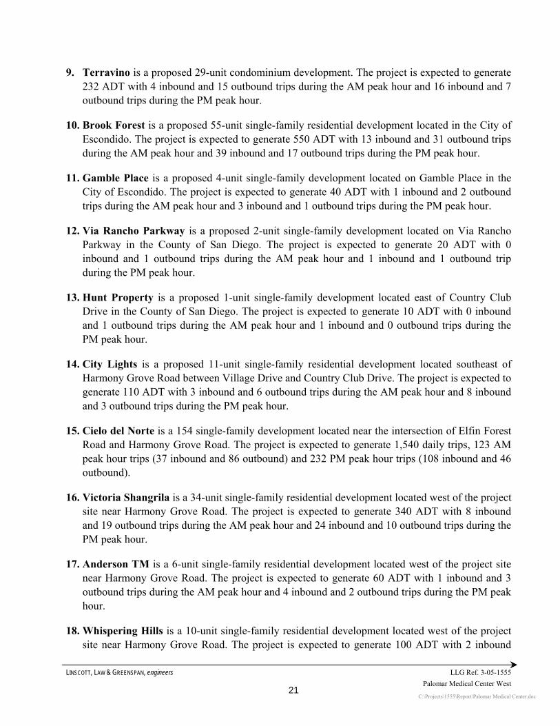
LINSCOTT, LAW & GREENSPAN, engineers LLG Ref. 3-05-1555 Palomar Medical Center West
C:\Projects\1555\Report\Palomar Medical Center.doc 21
9. Terravino is a proposed 29-unit condominium development. The project is expected to generate 232 ADT with 4 inbound and 15 outbound trips during the AM peak hour and 16 inbound and 7 outbound trips during the PM peak hour.
10. Brook Forest is a proposed 55-unit single-family residential development located in the City of Escondido. The project is expected to generate 550 ADT with 13 inbound and 31 outbound trips during the AM peak hour and 39 inbound and 17 outbound trips during the PM peak hour.
11. Gamble Place is a proposed 4-unit single-family development located on Gamble Place in the City of Escondido. The project is expected to generate 40 ADT with 1 inbound and 2 outbound trips during the AM peak hour and 3 inbound and 1 outbound trips during the PM peak hour.
12. Via Rancho Parkway is a proposed 2-unit single-family development located on Via Rancho Parkway in the County of San Diego. The project is expected to generate 20 ADT with 0 inbound and 1 outbound trips during the AM peak hour and 1 inbound and 1 outbound trip during the PM peak hour.
13. Hunt Property is a proposed 1-unit single-family development located east of Country Club Drive in the County of San Diego. The project is expected to generate 10 ADT with 0 inbound and 1 outbound trips during the AM peak hour and 1 inbound and 0 outbound trips during the PM peak hour.
14. City Lights is a proposed 11-unit single-family residential development located southeast of Harmony Grove Road between Village Drive and Country Club Drive. The project is expected to generate 110 ADT with 3 inbound and 6 outbound trips during the AM peak hour and 8 inbound and 3 outbound trips during the PM peak hour.
15. Cielo del Norte is a 154 single-family development located near the intersection of Elfin Forest Road and Harmony Grove Road. The project is expected to generate 1,540 daily trips, 123 AM peak hour trips (37 inbound and 86 outbound) and 232 PM peak hour trips (108 inbound and 46 outbound).
16. Victoria Shangrila is a 34-unit single-family residential development located west of the project site near Harmony Grove Road. The project is expected to generate 340 ADT with 8 inbound and 19 outbound trips during the AM peak hour and 24 inbound and 10 outbound trips during the PM peak hour.
17. Anderson TM is a 6-unit single-family residential development located west of the project site near Harmony Grove Road. The project is expected to generate 60 ADT with 1 inbound and 3 outbound trips during the AM peak hour and 4 inbound and 2 outbound trips during the PM peak hour.
18. Whispering Hills is a 10-unit single-family residential development located west of the project site near Harmony Grove Road. The project is expected to generate 100 ADT with 2 inbound

LINSCOTT, LAW & GREENSPAN, engineers LLG Ref. 3-05-1555 Palomar Medical Center West
C:\Projects\1555\Report\Palomar Medical Center.doc 22
and 6 outbound trips during the AM peak hour and 7 inbound and 3 outbound trips during the PM peak hour.
19. Little Creek is a 3-unit single-family residential development located west of the project site near Harmony Grove Road. The project is expected to generate 30 ADT with 1 inbound and 2 outbound trips during the AM peak hour and 2 inbound and 1 outbound trips during the PM peak hour.
20. McDonald Residence is a 1-unit single-family residential development located west of the project site near Harmony Grove Road. The project is expected to generate 10 ADT with 0 inbound and 1 outbound trips during the AM peak hour and 1 inbound and 0 outbound trips during the PM peak hour.
21. Christward Ministry is a proposed 12-unit dormitory located west of the project site near Harmony Grove Road. The project is expected to generate 72 ADT with 1 inbound and 5 outbound trips during the AM peak hour and 5 inbound and 2 outbound trips during the PM peak hour.
22. Harmony Grove Village is located on a 468-acre site located north of Harmony Grove Road and west of Country Club Drive in San Diego County. The project is proposing to develop 710 residential single-family units, 32 live / work lofts with 16,500 square-feet of retail, a 25,000-square foot village core, an equestrian park, a park, and open play fields. The total tips in the traffic study also include the proposed development of a private equestrian facility and 3,500 square feet (SF) of equestrian related retail, south of Harmony Grove. Harmony Grove is calculated to generate a total of 8,556 daily project trips. The project is calculated to generate 646 trips (238 inbound and 408 outbound trips) during the AM peak hour and 883 trips (565 inbound and 318 outbound trips) during the PM peak hour. Project data was obtained from the Harmony Grove Village Traffic Study conducted by LLG.

LINSCOTT, LAW & GREENSPAN, engineers LLG Ref. 3-05-1555 Palomar Medical Center West
C:\Projects\1555\Report\Palomar Medical Center.doc
23
Table 8-1 Cumulative Projects Trip Generation Summary
AM Peak Hour PM Peak Hour Daily Trip Ends (ADT) In:Out Volume In:Out Volume Project Land Use Size
Ratea Volume% of ADT Split In Out Total
% of ADT Split In Out Total
1. Chablis Court Industrial Building 37,500 SF 16 600 12% 80% 20% 58 14 72 12% 20% 80% 14 58 72 2. Executive Place Industrial Building 53,530 SF 16 856 12% 80% 20% 82 21 103 12% 20% 80% 21 82 103 3. Andreasen/Enterprise Industrial Building 56,974 SF 16 912 12% 80% 20% 88 22 110 12% 20% 80% 22 88 110 4. Equipment Wholesale Industrial (Addition) 6,000 SF 16 96 12% 80% 20% 9 2 11 12% 20% 80% 2 9 11
5. ERTCb Research Center 158 Acres - 9,863 - - - 1,154 128 1,282 - - - 256 1,026 1,282 6. Dorn Subdivision Single Family 34 Units 10 340 8% 30% 70% 8 19 27 10% 70% 30% 24 10 34 7. Harmony Grove Industrial Park Industrial 13.53 Acres 200 2,706 12% 80% 20% 260 65 325 12% 20% 80% 65 260 325 8. Bernardo Acres Single Family 15 Units 10 150 8% 30% 70% 4 8 12 10% 70% 30% 11 5 16 9. Terravino Condominiums 29 Units 8 232 8% 20% 80% 4 15 19 10% 70% 30% 16 7 23 10. Brook Forest Single Family 55 Units 10 550 8% 30% 70% 13 31 44 10% 70% 30% 39 17 56 11. Gamble Place Single Family 4 Units 10 40 8% 30% 70% 1 2 3 10% 70% 30% 3 1 4 12. Via Rancho Parkway Single Family 2 Units 10 20 8% 30% 70% - 1 1 10% 70% 30% 1 1 2 13. Hunt Property Single Family 1 Unit 10 10 8% 30% 70% - 1 1 10% 70% 30% 1 - 1 14. City Lights Single Family 11 Units 10 110 8% 30% 70% 3 6 9 10% 70% 30% 8 3 11 15. Cielo del Norte Single Family 154 Units 10 1,540 8% 30% 70% 37 86 123 10% 70% 30% 108 46 154 16. Victoria Shangrila Single Family 34 Units 10 340 8% 30% 70% 8 19 27 10% 70% 30% 24 10 34 17. Anderson TM Single Family 6 Units 10 60 8% 30% 70% 1 3 4 10% 70% 30% 4 2 6 18. Wispering Hills Single Family 10 Units 10 100 8% 30% 70% 2 6 8 10% 70% 30% 7 3 10 19 Little Creek Single Family 3 Units 10 30 8% 30% 70% 1 2 3 10% 70% 30% 2 1 3 20. McDonald Residence Single Family 1 Units 10 10 8% 30% 70% - 1 1 10% 70% 30% 1 - 1 21. Christward Ministry Dormitory 12 Units 6 72 8% 20% 80% 1 5 6 9% 70% 30% 5 2 7
22. Harmony Grove Village 742 Units 8,556 238 408 646 565 318 883 GRAND TOTAL — 27,193 — — — 1,972 865 2,837 — — — 1,199 1,949 3,148
Footnotes
a Rates based on SANDAG “Brief Guide to Vehicular Traffic Generation Rates in the San Diego Region”. b Excluding the PA-4 and PA-5 generated trips.

LINSCOTT, LAW & GREENSPAN, engineers
3-05-1555
Palomar Medical Center West
C:\Projects\1555\Report\Palomar Medical Center.doc
24
8.2 Summary Of Cumulative Projects Trips As seen in Table 8-1, the 22 cumulative projects are calculated to generate a total of 27,193 daily trips, 2,837 AM peak hour trips and 3,148 PM peak hour trips. Individual assignments of the traffic generated by each of the cumulative projects are included in Appendix D.
Figure 8-1 depicts the total AM and PM peak hour intersection and ADT volumes for the cumulative projects, while Figure 8-2 depicts the AM and PM peak hour and ADT volumes for the existing + project + cumulative projects scenario.


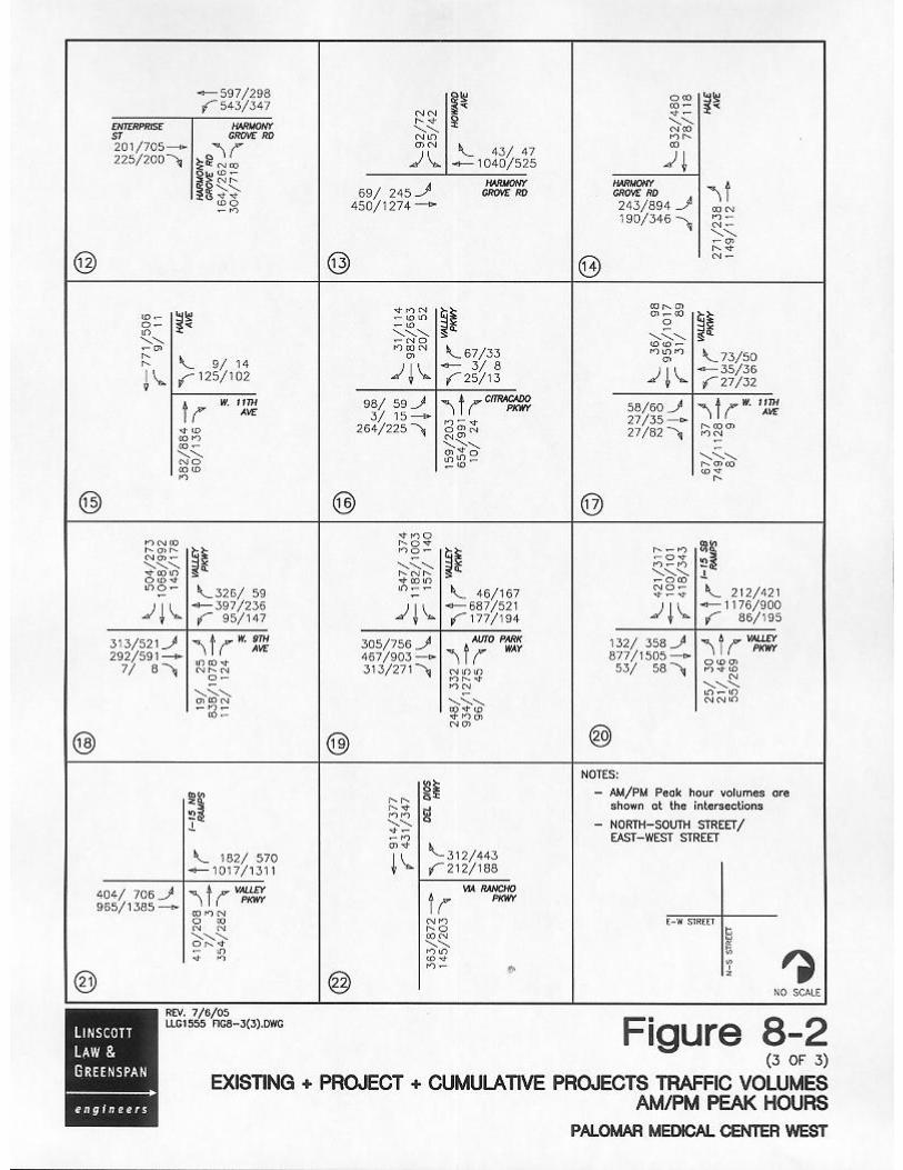

LINSCOTT, LAW & GREENSPAN, engineers
3-05-1555
Palomar Medical Center West
C:\Projects\1555\Report\Palomar Medical Center.doc
25
9.0 ANALYSIS OF FUTURE SCENARIOS 9.1 Existing + Project 9.1.1 Intersection Analysis Table 9-1 summarizes the existing + project signalized intersections level of service. As seen in Table 9-1, with the addition of project traffic, all intersections are calculated to operate at mid LOS D or better during both the AM and PM peak hours except the following signalized intersections:
Nordahl Road/SR-78 Westbound Ramps (LOS D during PM peak hour) Nordahl Road/SR-78 Eastbound Ramps (LOS F during both AM and PM peak hour) Nordahl Road/Mission Road (LOS F during both AM and PM peak hour) Del Dios Highway/Via Rancho Parkway (LOS F during PM peak hour)
Table 9-2 summarizes the existing + project unsignalized intersections level of service. As seen in Table 9-2, all intersections are calculated to operate at mid LOS D or better during both the AM and PM peak hours except the following unsignalized intersections:
Citracado Parkway/Country Club Drive (LOS F during both AM and PM peak hour) Citracado Parkway/Vineyard Avenue (LOS F during both AM and PM peak hour) Enterprise Street/Vineyard Avenue (LOS F during both AM and PM peak hour) Howard Avenue/Auto Park Way South (LOS F during PM peak hour) Harmony Grove Road/Enterprise Street (LOS F during AM peak hour and LOS E
during PM peak hour) Harmony Grove Road/Howard Avenue (LOS F during PM peak hour) Harmony Grove Road/Hale Avenue (LOS E during AM peak hour and LOS F during
PM peak hour)
Appendix E contains the existing + project intersection analysis worksheets.
9.1.2 Segment Analysis Table 9-3 shows a summary of the existing + project street segment operations in the project area. As seen in Table 9-3, with the addition of project traffic, all study area street segments are calculated to continue to operate at mid LOS D or better except the following street segments:
Nordahl Road, SR-78 to Mission Road (LOS F) Vineyard Avenue, Country Club Drive to Andreasen Drive (LOS F) Auto Parkway, Hale Avenue to Valley Parkway (LOS E) Harmony Grove Road, Enterprise Street to Hale Avenue (LOS F) West 9th Avenue, Hale Avenue to Home Depot Driveway (LOS F) West 9th Avenue, Auto Parkway to I-15 (LOS F) Valley Parkway, 11th Avenue to Citracado Parkway (LOS F)

LINSCOTT, LAW & GREENSPAN, engineers
3-05-1555
Palomar Medical Center West
C:\Projects\1555\Report\Palomar Medical Center.doc
26
Table 9–1 Near Term Signalized Intersection Operations
Existing Existing + Project Existing + Project + Cumulative Projects
Delay Intersection
Peak Period Delaya LOSb Delay LOS Δc Delay LOS
1. Nordahl Rd./SR-78 WB Ramps AM 34.5 C 34.7 C 0.2 38.3 D PM 41.8 D 49.9 D 8.1 87.9 F
2. Nordahl Rd./ SR-78 EB Ramps AM 49.3 D > 100 F > 10 > 100 F PM > 100 F > 100 F > 10 > 100 F
3. Nordahl Rd./Mission Rd. AM 45.5 D 80.9 F > 10 > 100 F PM 66.5 E > 100 F > 10 > 100 F
7. Andreasen Dr./Vineyard Ave. AM 29.2 C 29.2 C 0.0 33.9 C PM 28.6 C 31.9 C 3.3 39.6 D
9. Hale Ave./Auto Park Wy. AM 24.6 C 24.6 C 0.0 24.6 C PM 20.9 C 20.9 C 0.0 22.2 C
16. Valley Pkwy./Citracado Pkwy. AM 25.9 C 27.2 C 1.3 32.7 C PM 22.9 C 23.4 C 0.5 28.5 C
17. Valley Pkwy./West 11th Ave. AM 19.1 B 19.5 B 0.4 20.8 C PM 20.4 C 21.0 C 0.6 22.1 C
18. Valley Pkwy./West 9th Ave. AM 40.0 D 40.1 D 0.1 50.1 D PM 39.6 D 39.7 D 0.1 59.0 E
19. Valley Pkwy./Auto Pkwy. AM 36.3 D 37.2 D 0.9 38.6 D PM 40.4 D 42.1 D 1.7 47.1 D
20. I-15 SB Ramps/Valley Pkwy. AM 40.9 D 41.2 D 0.3 41.5 D PM 32.0 C 32.1 C 0.1 35.1 D
21. I-15 NB Ramps/Valley Pkwy. AM 30.2 C 30.2 C 0.0 31.4 C PM 34.0 C 34.0 C 0.0 34.0 C
22. Del Dios Hwy./Via Rancho Pkwy. AM 13.1 B 14.5 B 1.4 17.9 C PM 43.7 D 67.6 F > 10 > 100 F
Footnotes: a. Average delay expressed in seconds per vehicle. b. Level of Service. See Appendix C for delay thresholds. c. Δ denotes the change in delay due to addition of project traffic. d. Significant impacts shown in bold and shaded.

LINSCOTT, LAW & GREENSPAN, engineers
3-05-1555
Palomar Medical Center West
C:\Projects\1555\Report\Palomar Medical Center.doc
27
Table 9–2 Near Term Unsignalized Intersection Operations
Existing Existing + Project Existing + Project + Cumulative Projects
Intersection Peak
Period Delaya LOSb Delay LOS Delay Δc Delay LOS
4. Citracado Pkwy./ Country Club Dr. AM 33.1 D 58.7 F > 10 > 100 F [EBL] PM 32.3 D 78.5 F > 10 > 100 F
5. Citracado Pkwy./ Vineyard Ave. AM DNEe DNE > 100 F NA > 100 F [SB] PM DNE DNE > 100 F NA > 100 F
6. Enterprise St./ Vineyard Ave. AM 47.0 E > 100 F > 10 > 100 F [SBL] PM 64.3 F > 100 F > 10 > 100 F
8. Howard Ave./Auto Park Way So. AM 15.6 C 18.1 C 2.5 19.8 C [AWSC] PM 61.4 F > 100 F > 10 > 100 F
10. Harmony Grove Rd./Kauana Loa Dr. AM 9.9 A 10.2 B 0.3 11.4 B [NB] PM 12.2 B 12.6 B 0.4 19.0 C
11. Andreasen Dr./Enterprise St. AM 10.0 A 11.1 B 1.1 69.5 F [AWSC] PM 10.7 B 12.5 B 1.8 33.0 D
12. Harmony Grove Rd./Enterprise St. AM 34.6 D 80.0 F > 10 > 100 F [NBL] PM 19.8 C 41.4 E > 10 > 100 F
13. Harmony Grove Rd./Howard Ave. AM 17.9 C 21.9 C 4.0 77.6 F [SBL] PM 36.6 E 60.1 F > 10 > 100 F
14. Harmony Grove Rd./Hale Ave. AM 22.1 C 40.9 E > 10 > 100 F [EBL] PM 42.4 E > 100 F > 10 > 100 F
15. Hale Ave./West 11th Ave. AM 14.4 B 15.5 C 1.1 82.3 F [WBL] PM 16.6 C 18.5 C 1.9 > 100 F
Footnotes: a. Average delay expressed in seconds per vehicle. b. Level of Service. See Appendix C for delay thresholds. c. Δ denotes the Maximum change in delay due to addition of project traffic. d. NB – Northbound movement; SB – Southbound movement; EBL – Eastbound Left movement; WBL – Westbound Left turn movement;
NBL – Northbound Left turn movement; SBL – Southbound Left turn movement; EBL – Eastbound Left turn movement; AWSC – All Way Stop Control.
e. DNE – Do Not Exist f. Bold and shading indicates significant impact.

LINSCOTT, LAW & GREENSPAN, engineers LLG Ref. 3-05-1555 Palomar Medical Center West
C:\Projects\1555\Report\Palomar Medical Center.doc
28
TABLE 9-3 NEAR-TERM STREET SEGMENT OPERATIONS
Existing Existing+Project Existing + Project + Cumulative Projects
Segment
Capacity LOS E
ADT V/C LOS ADT V/C LOS
V/C Change due to project ADT V/C LOS
NORDHAL ROAD SR-78 to Mission Rd. 37,000 35,900 0.97 E 40,050 1.08 F 0.11 46,930 1.27 F
CITRACADO PARKWAY East Mission Rd. to Country Club Dr. 37,000 21,990 0.59 B 28,640 0.77 C 0.18 37,340 1.01 F
VINEYARD AVENUE Country Club Dr. to Citracado Pkwy. 15,000 19,960 1.33 F 26,100 1.74 F 0.47 31,890 2.13 F Citracado Pkwy. to Enterprise St. 15,000 19,960 1.33 F 26,100 1.74 F 0.47 29,700 1.98 F Enterprise St. to Andreasen Dr. 15,000 20,090 1.34 F 26,190 1.75 F 0.41 30,090 2.01 F
AUTO PARKWAY Hale Ave. to Valley Pkwy. 34,200 29,060 0.85 D 32,460 0.95 E 0.10 34,660 1.01 F
HARMONY GROVE ROAD Country Club Dr. to Kauana Loa Dr. 16,200 5,570 0.34 C 6,080 0.38 C 0.03 9,980 0.62 D Kauana Loa Dr. to Enterprise St. 15,000 7,210 0.48 B 7,890 0.53 C 0.05 9,800 0.65 C Enterprise St. to Howard Rd. 10,000 8,400 0.84 D 10,620 1.06 F 0.22 18,360 1.84 F Howard Rd. to Hale Ave. 10,000 9,150 0.92 E 11,370 1.14 F 0.22 17,360 1.74 F
HALE AVENUE Harmony Grove Rd. to 9th Ave. 10,000 7,100 0.71 C 7,740 0.77 D 0.05 13,090 1.31 F Harmony Grove Rd. to Avenida Del 15,000 5,660 0.38 B 6,510 0.43 B 0.06 7,900 0.53 C
WEST 9TH AVENUE Hale Ave. to Home Depot Dwy. 10,000 9,700 0.97 E 10,210 1.02 F 0.05 15,050 1.51 F Valley Pkwy. to Auto Pkwy. 15,000 10,400 0.69 D 10,910 0.73 D 0.03 14,010 0.93 E Auto Pkwy. to I-15 37,000 35,400 0.96 F 36,950 1.00 F 0.04 40,840 1.10 F
VALLEY PARKWAY Auto Pkwy. to I-15 60,000 43,570 0.73 D 44,930 0.75 D 0.02 48,990 0.82 D West 9th Ave. to 11th Ave. 37,000 25,480 0.69 C 26,330 0.71 C 0.02 28,110 0.76 C 11th Ave. to Citracado Pkwy. 15,000 20,450 1.36 F 21,810 1.45 F 0.09 22,430 1.50 F
ANDREASON DRIVE Vineyard Ave. to Enterprise St. 15,000 6,760 0.45 B 6,930 0.46 B 0.01 8,030 0.54 C
Footnote: a Bold and shading indicates significant impact.

LINSCOTT, LAW & GREENSPAN, engineers LLG Ref. 3-05-1555 Palomar Medical Center West
C:\Projects\1555\Report\Palomar Medical Center.doc
29
9.1.3 Freeway Operations Table 9-4 shows the peak hour analysis results for the freeway segments in the project area on freeway segments that have more than 50 peak hour trips. As shown in Table 9–4, all freeway segments in the project area are calculated to operate at LOS D or better with the addition of project traffic, except for the following:
SR-78 West of Nordahl Road eastbound (LOS F(0) during the PM peak hour);
I-15 south of W. 9th Street southbound (LOS E during the AM peak hour);

LINSCOTT, LAW & GREENSPAN, engineers LLG Ref. 3-05-1555 Palomar Medical Center West
C:\Projects\1555\Report\Palomar Medical Center.doc
30
TABLE 9-4
EXISTING + PROJECT - FREEWAY SEGMENT OPERATIONS
Existing Project Existing + Project V/C LOS V/C Delta Significant
Volume V/C Freeway Segment Direction # of
Lanes Capacity
AM PM AM PM AM PM AM PM AM PM AM PM AM PM AM PM
SR-78 EB 3M 6900 5565 8208 0.806 1.190 116 81 5681 8289 0.823 1.201 D F(0) 0.017 0.012 No Yes West of
Nordahl Rd. WB 3M 6900 6275 6192 0.909 0.897 <50 151 N/A 6343 N/A 0.919 N/A D N/A 0.022 N/A No I-15
NB 4M 9200 6015 9352 0.654 1.017 134 94 6149 9446 0.668 1.027 C F(0) 0.015 0.010 No Yes South of 9th Ave. SB 4M 9200 9023 6499 0.981 0.706 <50 174 N/A 6673 N/A 0.725 N/A C N/A 0.019 N/A No
Footnotes: a. Capacity calculated at 2300 ADT per mainline lane (M: Mainline, A: Aux. Ex. 4M+2A = 4 Mainline + 2 Aux). b. Peak Hour Percentage and Direction Split from CALTRANS. c. Truck Factor from "2000 Annual Average Daily Truck Traffic on the California State Highway System", January 2002. d. Peak Hour Volume = ((ADT)(K)(D)/Truck Factor). e. V/C = ((ADT)(K)(D)/Truck Factor/Capacity). f. NA: Not Applicable as project adds less than 50 peak hour trips.
LOS v/c A <0.41 C 0.8 D 0.92 E 1
F(0) 1.25 F(1) 1.35 F(2) 1.45 F(3) >1.46

LINSCOTT, LAW & GREENSPAN, engineers LLG Ref. 3-05-1555 Palomar Medical Center West
C:\Projects\1555\Report\Palomar Medical Center.doc
31
9.2 Existing + Project + Cumulative Projects 9.2.1 Intersection Analysis Table 9-1 summarizes the existing + project + cumulative projects signalized intersections level of service. As seen in Table 9-1, with the addition of project and cumulative projects traffic, all intersections are calculated to operate at mid LOS D or better during both the AM and PM peak hours except the following signalized intersections:
Nordahl Road/SR-78 Westbound Ramps (LOS F during PM peak hour) Nordahl Road/SR-78 Eastbound Ramps (LOS F during both AM and PM peak hour) Nordahl Road/Mission Road (LOS F during both AM and PM peak hour) Valley Parkway/West 9th Avenue (LOS D during AM peak hour and LOS E during
PM peak hour) Valley Parkway/Auto Parkway (LOS D during PM peak hour) Del Dios Highway/Via Rancho Parkway (LOS F during PM peak hour)
Table 9-2 summarizes the existing + project + cumulative projects unsignalized intersections level of service. As seen in Table 9-2, all intersections are calculated to operate at mid LOS D or better during both the AM and PM peak hours except the following unsignalized intersections:
Citracado Parkway/Country Club Drive (LOS F during both AM and PM peak hour) Citracado Parkway/Vineyard Avenue (LOS F during both AM and PM peak hour) Enterprise Street/Vineyard Avenue (LOS F during both AM and PM peak hour) Howard Avenue/Auto Park Way South (LOS F during PM peak hour) Andreasen Drive/Enterprise Street (LOS F during AM peak hour and LOS D during
PM peak hour) Harmony Grove Road/Enterprise Street (LOS F during both AM and PM peak hour) Harmony Grove Road/Howard Avenue (LOS F during both AM and PM peak hour) Harmony Grove Road/Hale Avenue (LOS F during both AM and PM peak hour) Hale Avenue/West 11th Avenue (LOS F during both AM peak and PM peak hour)
Appendix F contains the existing + project + cumulative projects intersection analysis worksheets.

LINSCOTT, LAW & GREENSPAN, engineers LLG Ref. 3-05-1555 Palomar Medical Center West
C:\Projects\1555\Report\Palomar Medical Center.doc
32
9.2.2 Segment Operations Table 9-3 shows a summary of the existing + project + cumulative projects street segment operations in the project area. As seen in Table 9-3, with the addition of project and cumulative projects traffic, all study area street segments are calculated to operate at mid LOS D or better conditions except the following street segments:
Nordahl Road, SR-78 to Mission Road (LOS F) Citracado Parkway, Mission Road to Country Club Drive (LOS F) Vineyard Avenue, Country Club Drive to Andreasen Drive (LOS F) Auto Parkway, Hale Avenue to Valley Parkway (LOS F) Harmony Grove Road, Enterprise Street to Howard Road (LOS F) Harmony Grove Road, Howard Avenue to Hale Avenue (LOS F) Hale Avenue, Harmony Grove Road to 9th Avenue (LOS F) West 9th Avenue, Hale Avenue to Home Depot Driveway (LOS F) West 9th Avenue, Valley Parkway to Auto Parkway (LOS E) West 9th Avenue, Auto Parkway to I-15 (LOS F) Valley Parkway, Auto Parkway to I-15 (LOS F) Valley Parkway, 11th Avenue to Citracado Parkway (LOS F)
9.2.3 Freeway Operations Table 9-5 shows the peak hour analysis results for the freeway segments in the project area on freeway segments that have more than 50 peak hour trips. As shown in Table 9–4, all freeway segments in the project area are calculated to operate at LOS D or better with the addition of project traffic, except for the following:
SR-78 West of Nordahl Road eastbound (LOS F(0) during the PM peak hour)
SR-78 West of Nordahl Road westbound (LOS E during the PM peak hour)
I-15 south of W. 9th Street southbound (LOS E during the AM peak hour)
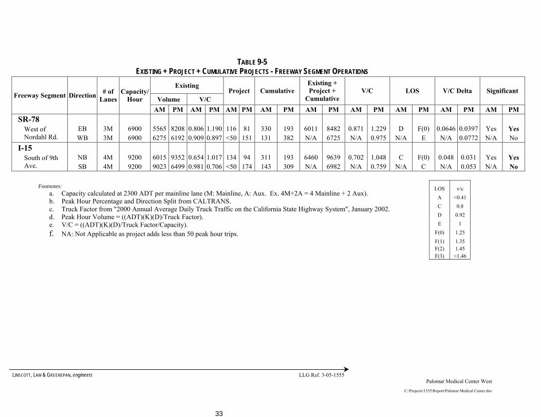
LINSCOTT, LAW & GREENSPAN, engineers LLG Ref. 3-05-1555 Palomar Medical Center West
C:\Projects\1555\Report\Palomar Medical Center.doc
33
TABLE 9-5
EXISTING + PROJECT + CUMULATIVE PROJECTS - FREEWAY SEGMENT OPERATIONS Existing
Volume V/C Project Cumulative
Existing + Project +
Cumulative V/C LOS V/C Delta Significant
Freeway Segment Direction # of Lanes
Capacity/Hour
AM PM AM PM AM PM AM PM AM PM AM PM AM PM AM PM AM PM SR-78
EB 3M 6900 5565 8208 0.806 1.190 116 81 330 193 6011 8482 0.871 1.229 D F(0) 0.0646 0.0397 Yes Yes West of Nordahl Rd. WB 3M 6900 6275 6192 0.909 0.897 <50 151 131 382 N/A 6725 N/A 0.975 N/A E N/A 0.0772 N/A No
I-15 NB 4M 9200 6015 9352 0.654 1.017 134 94 311 193 6460 9639 0.702 1.048 C F(0) 0.048 0.031 Yes Yes South of 9th
Ave. SB 4M 9200 9023 6499 0.981 0.706 <50 174 143 309 N/A 6982 N/A 0.759 N/A C N/A 0.053 N/A No
Footnotes: a. Capacity calculated at 2300 ADT per mainline lane (M: Mainline, A: Aux. Ex. 4M+2A = 4 Mainline + 2 Aux). b. Peak Hour Percentage and Direction Split from CALTRANS. c. Truck Factor from "2000 Annual Average Daily Truck Traffic on the California State Highway System", January 2002. d. Peak Hour Volume = ((ADT)(K)(D)/Truck Factor). e. V/C = ((ADT)(K)(D)/Truck Factor/Capacity). f. NA: Not Applicable as project adds less than 50 peak hour trips.
LOS v/c A <0.41 C 0.8 D 0.92 E 1
F(0) 1.25 F(1) 1.35 F(2) 1.45 F(3) >1.46

LINSCOTT, LAW & GREENSPAN, engineers LLG Ref. 3-05-1555 Palomar Medical Center West
C:\Projects\1555\Report\Palomar Medical Center.doc
34
10.0 YEAR 2030 ANALYSIS 10.1.1 Segment Operations The year 2030 traffic volumes were estimated based on the SANDAG Series 10 traffic forecast. Figure 10-1 depicts Year 2030 ADT volumes. Table 10-1 summarizes the daily segment levels of service on key segments for the year 2030. As seen in Table 10-1, the key segments are calculated to operate at mid-LOS D or better in the Year 2030 without project, except the following:
Nordahl Road, SR-78 to Mission Road (LOS F) Citracado Parkway, Mission Road to Country Club Drive (LOS F) Vineyard Avenue, Country Club Drive to Andreasen Drive (LOS F) Auto Parkway, Hale Avenue to Valley Parkway (LOS F) Hale Avenue, Harmony Grove Road to 9th Avenue (LOS F) West 9th Avenue, Hale Avenue to I-15 (LOS F) Valley Parkway, Auto Parkway to I-15 (LOS F) Valley Parkway, 11th Avenue to Citracado Parkway (LOS F)
The traffic volumes generated by the ERTC project was already included in the 2030 SANDAG Model. Therefore, the difference of the traffic volume generated by the project and the previously proposed business park in PA-4 and PA-5 of the ERTC, is added to the 2030 forecast volume to obtain the 2030 total traffic volume with the project trips. As see in Table 10-1, the key segments are calculated to operate at mid-LOS D or better in the Year 2030 with project trips, except the following:
Nordahl Road, SR-78 to Mission Road (LOS F) Citracado Parkway, Mission Road to Country Club Drive (LOS F) Vineyard Avenue, Country Club Drive to Andreasen Drive (LOS F) Auto Parkway, Hale Avenue to Valley Parkway (LOS F) Hale Avenue, Harmony Grove Road to 9th Avenue (LOS F) West 9th Avenue, Hale Avenue to I-15 (LOS F) Valley Parkway, Auto Parkway to I-15 (LOS F) Valley Parkway, 11th Avenue to Citracado Parkway (LOS F)
10.1.2 Freeway Operations Table 10-2 shows the peak hour analysis results for the freeway segments in the project area on freeway segments that have more than 50 peak hour trips. As shown in Table 10–2, all freeway segments in the project area are calculated to operate at LOS D or better with the addition of project traffic, except for the following:
SR-78 West of Nordahl Road eastbound (LOS F(0) during the PM peak hour)
I-15 south of W. 9th Street southbound (LOS F during the AM peak hour)
I-15 south of W. 9th Street northbound (LOS F during the PM peak hour)


LINSCOTT, LAW & GREENSPAN, engineers LLG Ref. 3-05-1555 Palomar Medical Center West
C:\Projects\1555\Report\Palomar Medical Center.doc
35
TABLE 10-1
YEAR 2030 STREET SEGMENT VOLUMES YEAR 2030
without Project YEAR 2030 with Project STREET SEGMENT CAPACITY
(at LOS E)VOL LOS V/C VOL LOS V/C
NORDHAL ROAD
SR-78 to Mission Rd. 50,000 53,900 F 1.08 54,966 F 1.10
CITRACADO PARKWAY East Mission Rd. to Country Club Dr. 50,000 54,000 F 1.08 56,006 F 1.12
VINEYARD AVENUE Country Club Dr. to Citracado Pkwy. 34,200 40,800 F 1.19 43,156 F 1.26 Citracado Pkwy. to Enterprise St. 34,200 38,200 F 1.12 42,932 F 1.26 Enterprise St. to Andreasen Dr. 34,200 37600 F 1.10 41,756 F 1.22
AUTO PARKWAY
Hale Ave. to Valley Pkwy. 34,200 43300 F 1.27 45,080 F 1.32
HARMONY GROVE ROAD Country Club Dr. to Kauana Loa Dr. 34,200 12200 A 0.36 12,386 A 0.36 Kauana Loa Dr. to Enterprise St. 34,200 12100 A 0.35 10,620 A 0.31 Enterprise St. to Howard Rd. 34,200 22900 C 0.67 22,960 C 0.67 Howard Rd. to Hale Ave. 34,200 21700 B 0.63 22,192 B 0.65
HALE AVENUE Harmony Grove Rd. to 9th Ave. 15,000 17800 F 1.19 17,554 F 1.17 Harmony Grove Rd. to Avenida Del Diablo 15,000 9800 C 0.65 10,110 C 0.67
WEST 9TH AVENUE Hale Ave. to Home Depot Dwy. 34,200 20700 B 0.61 20,454 B 0.60 Home Depot Dwy. to Valley Pkwy. 34,200 18300 B 0.54 18,486 B 0.54 Auto Pkwy. To I-15 SB Ramps 37,000 51000 F 1.38 51,450 F 1.39
VALLEY PARKWAY Auto Pkwy. to I-15 60,000 61000 F 1.02 61,280 F 1.02 West 9th Ave. to 11th Ave. 60,000 35000 C 0.58 35,418 C 0.59 11th Ave. to Citracado Pkwy. 37,000 28000 C 0.76 29,036 C 0.78
Footnotes:
a. Capacity standards are obtained from the City of Escondido proposed level of service standards

LINSCOTT, LAW & GREENSPAN, engineers LLG Ref. 3-05-1555 Palomar Medical Center West
C:\Projects\1555\Report\Palomar Medical Center.doc
36
TABLE 10-2 2030 FREEWAY SEGMENT OPERATIONS
Freeway and Pk Hr % (K) Dir Split (D) Pk Hr Vol V/C LOS Segment
Direction # of Lanes Capacity/Hour ADT
AM PM AM PM Truck Factor AM PM AM PM AM PM
SR-78 EB 3M+1A 8,400 181,000 0.074 0.09 0.47 0.57 0.95 6,627 9,774 0.789 1.164 C F(0) West of Nordahl Rd. WB 3M+1A 8,400 181,000 0.074 0.09 0.53 0.43 0.95 7,472 7,373 0.890 0.878 D D
I-15 NB 5M+1A 13,000 349,000 0.074 0.078 0.4 0.59 0.93 11,108 17,270 0.854 1.328 D F(1) South of 9th Ave. SB 5M+3A 16,000 349,000 0.074 0.078 0.6 0.41 0.93 16,662 12,001 1.041 0.750 F(0) C
Footnotes: a. Capacity calculated at 2300 ADT per mainline lane (M: Mainline, A: Aux. Ex. 4M+2A = 4 Mainline + 2 Aux). b. Peak Hour Percentage and Direction Split from CALTRANS. c. Truck Factor from "2000 Annual Average Daily Truck Traffic on the California State Highway System", January 2002. d. Peak Hour Volume = ((ADT)(K)(D)/Truck Factor). e. V/C = ((ADT)(K)(D)/Truck Factor/Capacity). f. NA: Not Applicable as project adds less than 50 peak hour trips.
LOS v/c A <0.41 C 0.8 D 0.92 E 1
F(0) 1.25 F(1) 1.35 F(2) 1.45 F(3) >1.46

LINSCOTT, LAW & GREENSPAN, engineers LLG Ref. 3-05-1555 Palomar Medical Center West
C:\Projects\1555\Report\Palomar Medical Center.doc
37
11.0 CONGESTION MANAGEMENT PROGRAM COMPLIANCE The Congestion Management Program Update (CMP) was adopted in January 2003 by the SANDAG Board, and is intended to directly link land use, transportation and air quality through Level of Service performance. Local agencies are required by statute to conform to the CMP.
The CMP requires an Enhanced CEQA Review for all large projects that are expected to generate more than 2,400 ADT or more than 200 peak hour trips. Since the project is calculated to generate more than 2,400 ADT and over 200 peak hour trips, this level of review is required of the proposed project.
In 1993, the Institute of Transportation Engineers California Border Section and the San Diego Region Traffic Engineer’s Council established a set of guidelines to be used in the preparation of traffic impact studies that are subject to the Enhanced CEQA review process. This published document, which is titled 1993 Guidelines for Congestion Management Program Transportation Impact Reports for the San Diego Region, requires that a project study area be established as follows:
1) All streets and intersections on CMP principal arterials where the project will add 50 or more peak hour trips in either direction.
2) Mainline freeway locations where the project will add 50 or more peak hour trips in either direction.
This project will add more than 50 new peak hour trips to SR-78 and I-15, CMP Freeways, as listed in the 2003 Guidelines for Congestion Management Program Transportation Impact Reports for the San Diego Region; therefore, a freeway analysis is included. Existing freeway analysis is included in Section 6.0, while near-term (existing + project and existing + project + cumulative) freeway analysis is included in Section 9.0. Table 10–2 summarizes the Year 2030 freeway operations on SR 78 west of Nordahl Road and on I-15 south of 9th Avenue and south of Via Rancho Parkway. Following is a summary of the near and long-term and operations on SR 78 and I-15:
11.1 State Route 78 The segment of SR-78 west of Nordahl Road is calculated to generally operate at LOS D or better in the eastbound direction during the AM peak hour and LOS F(0) during the PM peak hours under all scenarios. A cumulative impact is calculated on the eastbound segment during the PM peak hour since the freeway operates at LOS F(0) under existing conditions and the project adds more than 0.01 to the volume over capacity (v / c) ratio. In the westbound direction, the segment is calculated to operate at LOS D during the AM and PM peak hours under all scenarios.

LINSCOTT, LAW & GREENSPAN, engineers LLG Ref. 3-05-1555 Palomar Medical Center West
C:\Projects\1555\Report\Palomar Medical Center.doc
38
11.2 Interstate 15 The segment of I-15 south of W. 9th Street in the northbound is calculated to operate at LOS D or better during the AM peak hour and LOS F(1) or better during the PM peak hour under all scenarios. A cumulative impact is calculated on the northbound segment during the PM peak hour since the freeway operates at LOS F(0) under existing conditions and the project adds more than 0.01 to the volume over capacity (v / c) ratio. In the southbound direction, this segment is calculated to operate at LOS F(0) during the AM peak hour and LOS C during the PM peak hour under all scenarios.

LINSCOTT, LAW & GREENSPAN, engineers LLG Ref. 3-05-1555 Palomar Medical Center West
C:\Projects\1555\Report\Palomar Medical Center.doc
39
12.0 ACCESS AND PARKING Access to the site is proposed to be provided via Citracado Parkway directly east of the project site via four (4) proposed driveways. The conceptual site plan is shown on Figure 2-1. General vehicular access to the hospital campus would be provided from only two entrance driveways. Each of these main entrance driveways would connect directly to a different hospital drop-off area and to a service loop road located along the perimeter of the hospital property. The northern main entrance driveway would connect directly to a drop-off circle near the women’s center. The southern main entrance driveway would connect directly to a drop-off circle between the outpatient services building, central services building and the southern parking structure. The emergency services area of the diagnostic and treatment wing would be accessible from both entrance driveways via the service loop road and another driveway connecting to the emergency drop-off circle. Near the southern boundary of the site, a service vehicle driveway would be constructed off Citracado Parkway for use by emergency and service vehicles only. This service entrance would also connect to the service loop road. From this entrance, service vehicles would be directed along the southern and western portions of the service loop road to the service loading area and emergency services area located in the west-central portion of the campus. A fourth driveway would be constructed to access the central plant building only. This entrance driveway would be located off Citracado Parkway in the northeastern corner of the site. Traffic signals should be planned at the middle driveways. The other two driveways should be designed such that inbound left turns are allowed, but outbound left turns are prohibited. A mixture of surface and garage parking spaces would be provided in the northern and southwestern portions of the campus. A total of 2,595 parking spaces would be provided onsite. Surface parking lots would be located along the northern and northwestern site boundaries and would connect to the central loop road. In addition, two five-story parking structures would be located in the southwestern portion of the site, also connecting to the central loop road.

LINSCOTT, LAW & GREENSPAN, engineers LLG Ref. 3-05-1555 Palomar Medical Center West
N:\1555\Report\July 2005\Palomar Medical Center 7-14-05.doc
41
13.0 SIGNIFICANCE OF IMPACTS AND MITIGATION MEASURES Table 13-1 summarizes the significant impacts and recommended mitigation measures calculated at the signalized intersections, unsignalized intersections, street segments and freeway segments, based on the established significance criteria. Impacts are termed either direct or cumulative. As previously discussed, an impact is considered cumulative if the facility already operates below City standards.
Table 13-2 shows the impacts that were identified in this traffic study that were not identified in the ERTC EIR. This table also shows the mitigation that would be necessary. However, since the improvements shown in Table 13-2 have been incorporated into the project description (as a project feature), the impacts would not occur and mitigation would not be necessary.
.

Location Jurisdiction Impact Type Mitigation Measure
SR-78 to Mission Road City of Escondido Cumulative
Contribute a fair share towards the City planned widening of Nordahl Road between the SR-78 westbound ramps and East Mission Road to six lanes. A joint City / Caltrans project study report is on-going at the interchange that will lead to the eventual improvement of the interchange.
Mission Road to Country Club Drive
City of Escondido Cumulative
Contribute a fair share toward the City planned improvements of the Nordahl Road / East Mission Road intersection. The improvements are part of a City Capital Improvement Project (CIP).
Country Club Drive to Andreason Drive
City of Escondido Cumulative
Contribute a fair share towards the widening of Vineyard Avenue betweenCountry Club Drive and Andreason Drive to four lanes (Collector Road standards).
Hale Avenue to Valley Parkway
City of Escondido Direct
Improve the Hale Avenue / Auto Park Way intersection to include (1) right-turn lane, (1) shared through / left lane, and (1) left-turn lane on the southbound approach with split phasing on the north / south approaches. The additional intersection capacity mitigates the segment impact.
Enterprise Street to Hale Avenue
City of Escondido Cumulative Contribute a fair share towards upgrading the existing roadway to 4 lanes
(Collector Standards).
Harmony Grove Road to W. 9th Street
City of Escondido Cumulative
Contribute a fair share towards Upgrading the existing roadway to Local Collector standards and upgrading unimproved sections of Hale Avenue immediately north of Harmony Grove Road and south of West 9th Street.
Hale Avenue to Home Depot Driveway
City of Escondido Cumulative Contribute a fair share towards upgrading the existing roadway to Local
Collector Standards.
Auto Park Way to I-15 City of Escondido Cumulative
Contribute a fair share towards restriping the eastbound approach on West 9th Street at Auto Park Way to a right-turn lane, a shared through / right lane, and a left-turn lane and the provision of right-turn overlap phasing on the eastbound approach. This intersection improvement would mitigate the segment impact
11th Avenue to Via Rancho Parkway
City of Escondido/ County of San Diego
Cumulative Contribute a fair share towards the widening of Valley Parkway between Via Rancho Parkway and 11th Avenue to 4 lanes.
Hale Avenue
West 9th Street
Citracado Parkway
Vineyard Avenue
Valley Parkway
Auto Park Way
Harmony Grove Road
Table 13-1Significant Impacts / Mitigation Measures Identified in the ERTC EIR
Nordahl RoadA. Street Segments
LINSCOTT, LAW GREENSPAN, engineers
LLG Ref. 3-05-1555Palomar Medical Center West

Location Jurisdiction Impact Type Mitigation Measure
Nordahl Road / SR-78 EB Ramps
City of Escondido / Caltrans
CumulativeContribute a fair share toward the future improvement of the SR-78 / Nordahl Road interchange. A joint City / Caltrans PSR is on-going at the interchange that will lead to the eventual improvement of the interchange.
Nordahl Road / Mission Road
City of Escondido Cumulative
Contribute a fair share toward the City planned widening of Nordahl Road between SR-78 and E. Mission Road to six-lanes. In addition to the City planned improvements, other additional turn lanes are needed to meet City LOS standards. The improvements are part of a past City CIP.
Del Dios Highway/Via Rancho Parkway
County of San Diego Direct
Provide an additional northbound through lane, a dedicated northbound right turn lane and a dedicated eastbound right turn lane (with an overlap phase) at the Del Dios Highway/Via Rancho Parkway intersection.
Citracado Parkway / Country Club Drive
City of Escondido Cumulative
Contribute a fair share toward the future signalization of the Citracado Parkway / Country Club Drive intersection. This improvement is part of the City CIP.
Citracado Parkway / Vineyard Avenue
City of Escondido Direct
Signalize the Citracado Parkway/Vineyard Avenue intersection and provide the following geometry: Northbound – dual left-turn lanes and one right-turn lane with overlap phase; Westbound – dual left-turn lanes and two through lanes; Eastbound – Two through lanes and one right-turn lane with overlap phase.
B. Signalized Intersections
Table 13-1 (Continued)Significant Impacts / Mitigation Measures
C. Unsignalized Intersections
LINSCOTT, LAW GREENSPAN, engineers
LLG Ref. 3-05-1555Palomar Medical Center West

Location Jurisdiction Impact Type Mitigation Measure
Enterprise Street/Vineyard Avenue
City of Escondido Cumulative Contribute a fairshare towards installing a traffic signal at the Enterprise
Street/Vineyard Avenue intersection.
Howard Avenue/Auto Park Way South
City of Escondido Cumulative Contribute a fair share towards installing a traffic signal at the Howard
Avenue/Auto Park Way South intersection.
Harmony Grove Road / Enterprise Street
City of Escondido Direct
Signalize the Harmony Grove Road/ Enterprise Street intersection and provide dedicated left-turn lanes on each approach and provide a northbound right turn lane with overlap phase.
Harmony Grove Road / Hale Avenue
City of Escondido Direct Signalize this intersection and provide dedicated left-turn lanes on each
approach.
SR-78 Caltrans Cumulative Mitigation is not available to mitigate SR-78 freeway impacts to below a level of significance. This impact is considered unmitigable.
I-15 Caltrans Cumulative Mitigation is not available to mitigate SR-78 freeway impacts to below a level of significance. This impact is considered unmitigable.
D. Freeways
C. Unsignalized Intersections
Table 13-1 (Continued)
Significant Impacts / Mitigation Measures
LINSCOTT, LAW GREENSPAN, engineers
LLG Ref. 3-05-1555Palomar Medical Center West

Location Jurisdiction Impact Type Project Feature
Valley Parkway to Auto Park Way
City of Escondido Cumulative
Contribute a fair share towards restriping the eastbound approach on West 9th Street at Auto Park Way to a right-turn lane, a shared through / right lane, and a left-turn lane and the provision of right-turn overlap phasing on the eastbound approach. This intersection improvement would mitigate the segment impact.
Auto Park Way to I-15 & I-15/Valley Parkway Ramp Meter
City of Escondido Cumulative
Contribute a fair share toward the future improvements of the Valley Parkway / I-15 interchange. The additional interchange capacity would mitigate the cumulative segment impact and the cumulative ramp meter impact.
Nordahl Road / SR-78 WB Ramps Intersection and SR-78/Nordahl Road Ramp Meter
City of Escondido/ Caltrans
Direct
Contribute a fair share toward the future improvement of the SR-78 / Nordahl Road interchange. A joint City / Caltrans PSR is on-going at the interchange that will lead to the eventual improvement of the interchange.
Harmony Grove Road / Howard Avenue Intersection
City of Escondido Cumulative Contribute a fair share toward the signalization of this intersection with
dedicated left-turn lanes.
C. Unsignalized Intersections
A. Street SegmentsWest 9th Street
Valley Parkway
B. Signalized Intersections
Table 13-2Locations Significantly Mitigated By Project Features
LINSCOTT, LAW GREENSPAN, engineers
LLG Ref. 3-05-1555Palomar Medical Center West

ATTACHMENT 3 AIR QUALITY TECHNICAL REPORT
(SRA 2005)


Air Quality Technical Report
for the
Palomar Medical Center West
Submitted To:
Palomar Pomerado Health 15255 Innovation Drive
San Diego, CA 92128
Prepared By:
1328 Kaimalino Lane
San Diego, CA 92109
November 17, 2005
DRAFT
Air Quality Technical Report 1 11/18/05 Palomar Medical Center West
1.0 Introduction
This report presents an assessment of potential air quality impacts associated with the proposed
Palomar Medical Center West development in the City of Escondido. The evaluation addresses
the potential for air emissions during construction and after full buildout of the project, including
an assessment of the potential for CO “hot spots” to form due to traffic associated with the
proposed project.
The proposed Palomar Medical Center West project involves construction of a new hospital
facility on Planning Areas 4 and 5 of the adopted Escondido Research and Technology Center
(ERTC) Specific Plan site. The project is located in the western section of the City of
Escondido, south of State Route (SR) 78 and southwest of the Vineyard Drive/Citracado
Parkway intersection. The site would be developed into a hospital/medical campus with
approximately 1.2 million gross square feet (gsf) of building space. The project would construct
a new 453-bed hospital building, with approximately 360 beds provided for general inpatient
services and the remaining 93 beds provided as part of a women’s center. The hospital building
would have several wings with varying numbers of floors and would be generally located in the
north-central portion of the proposed hospital campus. Two, 10-to-12 story nursing towers
would be located in the central portion of the hospital providing 314,000 gsf of building space
for the 360 inpatient beds. Diagnostic and treatment services would be provided in a 228,000 gsf
hospital wing in the southwestern portion of the hospital. The diagnostic and treatment services
wing would include emergency services, imaging, surgery, an outpatient diagnostic center, and
hospital support services. The women’s center would be located in the northeastern hospital
wing of the hospital building, providing a total of 110,000 gsf of building space. The women’s
center would offer the following services: labor and delivery, neonatal intensive care unit
(NICU), post partum, and an outpatient center.
A separate central services building would provide approximately 91,000 gsf of building space
for a reference lab, a warehouse, information technology/information systems (IT/IS) and food

DRAFT
Air Quality Technical Report 2 11/18/05 Palomar Medical Center West
services. The central services building would be two stories in height and would be located in
the southern portion of the hospital campus.
A hospital support building would be constructed on the campus to provide 258,000 gsf of
building space in four-to-eight stories for support services, administrative services, a conference
center, and outpatient services. The hospital support building would be connected to the
southeastern wing of the hospital campus. In addition, a separate outpatient services building
would be constructed in the central portion of the hospital campus. This building would provide
approximately 160,000 gsf of building space in four-to-eight stories. Finally, a 50,000 gsf
central plant would be constructed in the northeastern corner of the site. This building would be
three stories in height.
The project site would be accessed from five driveways located off Citracado Parkway. A
mixture of surface and garage parking spaces would be provided in the northern, southwestern
and southern portions of the hospital/medical campus. A total of 2,595 parking spaces would be
provided onsite. A large surface parking lot would be located along the northern and
northwestern site boundaries and a smaller surface lot would be located in the southern portion
of the site. Both would connect to the central loop road. In addition, two five-story parking
structures would be located in the southwestern portion of the site, also connecting to the central
loop road.
A helipad would be constructed onsite for helicopters transporting trauma patients. The
preferred location for the helipad is on the roof of the western nursing tower in the northwestern
portion of the hospital campus.
This Air Quality Technical Report includes an evaluation of existing conditions in the project
vicinity, an assessment of potential impacts associated with project construction, and an
evaluation of project operational impacts.
DRAFT
Air Quality Technical Report 3 11/18/05 Palomar Medical Center West
2.0 Existing Conditions
Existing Setting
The project site is located in the City of Escondido, south of SR-78 and southwest of the
Vineyard Drive/Citracado Parkway intersection. The site is located in the Escondido Research
and Technology Center, in Planning Areas 4 and 5 of the site.
Climate and Meteorology
The project site is located in the San Diego Air Basin (SDAB). The climate of the SDAB is
dominated by a semi-permanent high pressure cell located over the Pacific Ocean. This cell
influences the direction of prevailing winds (westerly to northwesterly) and maintains clear skies
for much of the year. Figure 2 provides a graphic representation of the prevailing winds in the
project vicinity, as measured at the San Diego Air Pollution Control District’s (APCD’s)
Escondido Monitoring Station (the closest meteorological monitoring station to the site). The
high pressure cell also creates two types of temperature inversions that may act to degrade local
air quality.
Subsidence inversions occur during the warmer months as descending air associated with the
Pacific high pressure cell comes into contact with cool marine air. The boundary between the
two layers of air creates a temperature inversion that traps pollutants. The other type of
inversion, a radiation inversion, develops on winter nights when air near the ground cools by
heat radiation and air aloft remains warm. The shallow inversion layer formed between these
two air masses also can trap pollutants. As the pollutants become more concentrated in the
atmosphere, photochemical reactions occur that produce ozone, commonly known as smog.

DRAFT
Air Quality Technical Report 4 11/18/05 Palomar Medical Center West
Figure 2. Wind Rose – Escondido Monitoring Station
2.1 Regulatory Setting
Air quality is defined by ambient air concentrations of specific pollutants identified by the
United States Environmental Protection Agency (USEPA) to be of concern with respect to health
and welfare of the general public. The USEPA is responsible for enforcing the Federal Clean
Air Act (CAA) of 1970 and its 1977 and 1990 Amendments. The CAA required the USEPA to
establish National Ambient Air Quality Standards (NAAQS), which identify concentrations of
pollutants in the ambient air below which no adverse effects on the public health and welfare are
anticipated. In response, the USEPA established both primary and secondary standards for
several pollutants (called “criteria” pollutants). Primary standards are designed to protect human
health with an adequate margin of safety. Secondary standards are designed to protect property
and the public welfare from air pollutants in the atmosphere.
In September 1997, the EPA promulgated 8-hour O3 and 24-hour and annual PM2.5 national
standards (particulate matter less than 2.5 microns in diameter). However, due to a lawsuit in
May 1999, the United States District Court rescinded these standards and the EPA’s authority to
DRAFT
Air Quality Technical Report 5 11/18/05 Palomar Medical Center West
enforce them. Subsequent to an appeal of this decision by the EPA, the United States Supreme
Court in February 2001 upheld these standards. As a result, this action has initiated a new
planning process to monitor and evaluate emission control measures for these pollutants. The
EPA is moving forward to develop policies to implement these standards.
The CAA allows states to adopt ambient air quality standards and other regulations provided
they are at least as stringent as federal standards. The California Air Resources Board (ARB)
has established the more stringent California Ambient Air Quality Standards (CAAQS) for the
six criteria pollutants through the California Clean Air Act of 1988, and also has established
CAAQS for additional pollutants, including sulfates, hydrogen sulfide, vinyl chloride and
visibility-reducing particles. Areas that do not meet the NAAQS or the CAAQS for a particular
pollutant are considered to be “nonattainment areas” for that pollutant. In December 2002, the
San Diego Air Pollution Control District (SDAPCD) submitted a maintenance plan for the 1-
hour NAAQS for O3 and requested redesignation from a serious O3 nonattainment area to
attainment. As of July 28, 2003, the San Diego Air Basin (SDAB) has been reclassified as an
attainment area for the 1-hour NAAQS for O3. The SDAB has been designated a basic
nonattainment area for the 8-hour NAAQS for O3, and an attainment area for the NAAQS for
PM2.5. The SDAB is in attainment for the NAAQS for all other criteria pollutants. The SDAB is
currently classified as a nonattainment area under the CAAQS for O3, particulate matter less than
10 microns in aerodynamic diameter (PM10).
The ARB is the state regulatory agency with authority to enforce regulations to both achieve and
maintain the NAAQS and CAAQS. The ARB is responsible for the development, adoption, and
enforcement of the state’s motor vehicle emissions program, as well as the adoption of the
CAAQS. The ARB also reviews operations and programs of the local air districts, and requires
each air district with jurisdiction over a nonattainment area to develop its own strategy for
achieving the NAAQS and CAAQS. The local air district has the primary responsibility for the
development and implementation of rules and regulations designed to attain the NAAQS and
CAAQS, as well as the permitting of new or modified sources, development of air quality
management plans, and adoption and enforcement of air pollution regulations. The APCD is the

DRAFT
Air Quality Technical Report 6 11/18/05 Palomar Medical Center West
local agency responsible for the administration and enforcement of air quality regulations for San
Diego County.
The APCD and the San Diego Association of Governments (SANDAG) are responsible for
developing and implementing the clean air plan for attainment and maintenance of the ambient
air quality standards in the SDAB. The San Diego County Regional Air Quality Strategy
(RAQS) was initially adopted in 1991, and is updated on a triennial basis. The RAQS was
updated in 1995, 1998, 2001, and most recently in 2004. The RAQS outlines APCD’s plans and
control measures designed to attain the state air quality standards for O3. The APCD has also
developed the air basin’s input to the SIP, which is required under the Federal Clean Air Act for
areas that are out of attainment of air quality standards. The SIP includes the APCD’s plans and
control measures for attaining the O3 NAAQS. The SIP is also updated on a triennial basis.
The RAQS relies on information from ARB and SANDAG, including mobile and area source
emissions, as well as information regarding projected growth in the County, to project future
emissions and then determine from that the strategies necessary for the reduction of emissions
through regulatory controls. The ARB mobile source emission projections and SANDAG
growth projections are based on population and vehicle trends and land use plans developed by
the cities and by the County as part of the development of the County’s General Plan. As such,
projects that propose development that is consistent with the growth anticipated by the general
plans would be consistent with the RAQS. In the event that a project would propose
development which is less dense than anticipated within the general plan, the project would
likewise be consistent with the RAQS. If a project proposes development that is greater than that
anticipated in the general plan and SANDAG’s growth projections, the project might be in
conflict with the RAQS and SIP, and might have a potentially significant impact on air quality.
The SIP relies on the same information from SANDAG to develop emission inventories and
emission reduction strategies that are included in the attainment demonstration for the air basin.
The SIP also includes rules and regulations that have been adopted by the APCD to control
emissions from stationary sources. These SIP-approved rules may be used as a guideline to

DRAFT
Air Quality Technical Report 7 11/18/05 Palomar Medical Center West
determine whether a project’s emissions would have the potential to conflict with the SIP and
thereby hinder attainment of the NAAQS for O3.
Table 1 presents a summary of the ambient air quality standards adopted by the federal and
California Clean Air Acts.

DRAFT
Air Quality Technical Report 8 11/18/05 Palomar Medical Center West
Table 1 AMBIENT AIR QUALITY STANDARDS
CALIFORNIA STANDARDS NATIONAL STANDARDS
POLLUTANT AVERAGE TIME Concentration Measurement
Method Primary Secondary Measurement Method
1 hour 0.09 ppm (180 µg/m3)
0.12 ppm (235 µg/m3)
0.12 ppm (235 µg/m3) Ozone
(O3) 8 hour -- Ultraviolet Photometry 0.08 ppm
(157 µg/m3) 0.08 ppm
(157 µg/m3)
Ethylene Chemiluminescence
8 hours 9.0 ppm (10 mg/m3)
9 ppm (10 mg/m3) Carbon
Monoxide (CO) 1 hour 20 ppm
(23 mg/m3)
Non-Dispersive Infrared
Spectroscopy (NDIR)
35 ppm (40 mg/m3)
None Non-Dispersive
Infrared Spectroscopy
(NDIR) Annual Average -- 0.053 ppm
(100 µg/m3) 0.053 ppm
(100 µg/m3) Nitrogen Dioxide (NO2) 1 hour 0.25 ppm
(470 µg/m3)
Gas Phase Chemiluminescence -- --
Gas Phase Chemiluminescence
Annual Average -- 0.03 ppm
(80 µg/m3) --
24 hours 0.04 ppm (105 µg/m3)
0.14 ppm (365 µg/m3) --
3 hours -- -- 0.5 ppm (1300 µg/m3)
Sulfur Dioxide (SO2)
1 hour 0.25 ppm (655 µg/m3)
Ultraviolet Fluorescence
-- --
Pararosaniline
24 hours 50 µg/m3 150 µg/m3 150 µg/m3 Respirable Particulate
Matter (PM10) Annual
ArithmeticMean
20 µg/m3
Gravimetric or Beta Attenuation
50 µg/m3 50 µg/m3
Inertial Separation and Gravimetric
Analysis
Annual Arithmetic
Mean 12 µg/m3 15 µg/m3 15 µg/m3 Fine
Particulate Matter (PM2.5) 24 hours --
Gravimetric or Beta Attenuation
65 µg/m3 65 µg/m3
Inertial Separation and Gravimetric
Analysis
Sulfates 24 hours 25 µg/m3 Ion Chromatography -- -- -- 30-day
Average 1.5 µg/m3 -- -- Lead (Pb) Calendar
Quarter -- Atomic Absorption
1.5 µg/m3 1.5 µg/m3 Atomic Absorption
Hydrogen Sulfide (H2S)
1 hour 0.03 ppm (42 µg/m3)
Ultraviolet Fluorescence -- -- --
Vinyl Chloride 24 hours 0.010 ppm (26 µg/m3) Gas Chromatography -- -- --
ppm= parts per million µg/m3 = micrograms per cubic meter mg/m3= milligrams per cubic meter
Source: California Air Resources Board July 2003

DRAFT
Air Quality Technical Report 9 11/18/05 Palomar Medical Center West
2.2 Background Air Quality
The APCD operates a network of ambient air monitoring stations throughout San Diego County.
The purpose of the monitoring stations is to measure ambient concentrations of the pollutants
and determine whether the ambient air quality meets the CAAQS and the NAAQS. The nearest
ambient monitoring stations to the project site are the Escondido East Valley Parkway station,
and the San Diego 12th Avenue station (which is the closest station that measures SO2). Because
both the Escondido and San Diego 12th Avenue monitoring stations are located in areas where
there is substantial traffic congestion, it is likely that pollutant concentrations measured at those
monitoring stations are higher than concentrations that would be observed or measured in the
Project area, and would thus provide a conservative estimate of background ambient air quality.
Ambient concentrations of pollutants over the last three years are presented in Table 2.
Air quality has shown improvement in the SDAB such that the 1-hour federal ozone standard has
not been exceeded at the Escondido monitoring station from 2002-2004. The federal 8-hour
ozone standard, which was formally adopted in 2001 after legal arguments with the EPA, was
exceeded at the Escondido monitoring station twice in 2004. The SDAB has been classified as a
basic nonattainment area for the 8-hour NAAQS for O3. The federal 24-hour PM10 standard was
exceeded once at the Escondido monitoring station in 2003; however, the exceedance occurred
during the Cedar Fire event in San Diego County. The federal annual PM2.5 standard was
exceeded in 2002. The Escondido monitoring station measured exceedances of the state PM10
and PM2.5 standards during the period from 2002 to 2004. The data from the monitoring stations
indicate that air quality is in attainment of all other federal standards.
Concentrations of CO at the Escondido monitoring station tend to be among the highest in the
San Diego Air Basin, due to the fact that the monitor is located along East Valley Parkway in a
congested area in downtown Escondido. The station sees higher concentrations of CO than have
historically been measured elsewhere in San Diego County and the background data are not
likely to be representative of background ambient CO concentrations at the Project site, due to
the site’s location in a less developed area. Since 2000, CO has not been monitored at other
stations in northern San Diego County.

DRAFT
Air Quality Technical Report 10 11/18/05 Palomar Medical Center West
Table 2
Ambient Background Concentrations (ppm unless otherwise indicated)
Pollutant Averaging Time
2002 2003 2004 Most Stringent
Ambient Air Quality
Standard
Monitoring Station
Ozone 8 hour 0.081 0.083 0.086 0.08 Escondido 1 hour 0.100 0.105 0.099 0.09 Escondido PM10 Annual 25.1 µg/m3 32.7 µg/m3 28 µg/m3 20 µg/m3 Escondido 24 hour 51 µg/m3 179 µg/m3 58 µg/m3 50 µg/m3 Escondido PM2.5 Annual 16.0 µg/m3 14.2 µg/m3 13.5 µg/m3 12 µg/m3 Escondido 24 hour 53.6 µg/m3 69.2 µg/m3 67.3 µg/m3 65 µg/m3 Escondido NO2 Annual 0.021 0.020 0.018 0.053 Escondido 1 hour 0.084 0.135 0.078 0.25 Escondido CO 8 hour 3.85 10.64 3.56 9.0 Escondido 1 hour 8.5 12.7 6.3 20 Escondido SO2 Annual 0.003 0.005 0.004 80 San Diego 24 hour 0.007 0.008 0.008 105 San Diego 3 hour 0.015 0.019 0.018 13001 San Diego 1 hour 0.028 0.036 0.042 655 San Diego 1Secondary NAAQS Source: www.arb.ca.gov/aqd/aqd.htm (Measurements of all pollutants at Escondido-E Valley Parkway station, except SO2, ) www.epa.gov/air/data/monvals.html (2004 annual values, 1-hour and 3-hour SO2 and 1-hour CO)
3.0 Thresholds of Significance
The State of California has developed guidelines to address the significance of air quality
impacts based on Appendix G of the State CEQA Guidelines which provides guidance that a
project would have a significant environmental impact if it would:
1. Conflict or obstruct the implementation of the San Diego Regional Air Quality Strategy
(RAQS) or applicable portions of the State Implementation Plan (SIP);
2. Result in emissions that would violate any air quality standard or contribute substantially
to an existing or projected air quality violation;

DRAFT
Air Quality Technical Report 11 11/18/05 Palomar Medical Center West
3. Result in a cumulatively considerable net increase of PM10 or exceed quantitative
thresholds for O3 precursors, oxides of nitrogen (NOX) and volatile organic compounds
(VOCs);
4. Expose sensitive receptors (including, but not limited to, schools, hospitals, resident care
facilities, or day-care centers) to substantial pollutant concentrations; or
5. Create objectionable odors affecting a substantial number of people.
To determine whether a project would (a) result in emissions that would violate any air quality
standard or contribute substantially to an existing or projected air quality violation; or (b) result
in a cumulatively considerable net increase of PM10 or exceed quantitative thresholds for O3
precursors, oxides of nitrogen (NOX) and volatile organic compounds (VOCs), project emissions
may be evaluated based on the quantitative emission thresholds established by the San Diego
APCD. As part of its air quality permitting process, the APCD has established thresholds in
Rule 20.2 for the preparation of Air Quality Impact Assessments (AQIA).
For CEQA purposes, these screening criteria can be used as numeric methods to demonstrate that
a project’s total emissions would not result in a significant impact to air quality. Since APCD
does not have AQIA thresholds for emissions of VOCs, the use of the threshold for VOCs from
the City of San Diego’s Significance Thresholds (City of San Diego 2004) is appropriate. The
screening thresholds are included in the table below.

DRAFT
Air Quality Technical Report 12 11/18/05 Palomar Medical Center West
Table 3 SCREENING-LEVEL CRITERIA FOR AIR QUALITY IMPACTS
Pollutant Total Emissions
Construction Emissions
Lb. per Day Respirable Particulate Matter (PM10)
100
Oxides of Nitrogen (NOx) 250 Oxides of Sulfur (SOx) 250 Carbon Monoxide (CO) 550 Volatile Organic Compounds (VOCs)1
137
Operational Emissions Lb. Per Hour Lb. per Day Tons per Year Respirable Particulate Matter (PM10)
--- 100 15
Oxides of Nitrogen (NOx) 25 250 40 Oxides of Sulfur (SOx) 25 250 40 Carbon Monoxide (CO) 100 550 100 Lead and Lead Compounds --- 3.2 0.6 Volatile Organic Compounds (VOC)2
--- 137 15
The thresholds listed in Table 3 represent screening-level thresholds that can be used to evaluate
whether project-related emissions could cause a significant impact on air quality. Emissions
below the screening-level thresholds would not cause a significant impact. In the event that
emissions exceed these thresholds, modeling would be required to demonstrate that the project’s
total air quality impacts result in ground-level concentrations that are below the State and Federal
Ambient Air Quality Standards, including appropriate background levels. For nonattainment
pollutants (ozone, with ozone precursors NOx and VOCs) and PM10, if emissions exceed the
thresholds shown in Table 3, the project could have the potential to result in a cumulatively
considerable net increase in these pollutants and thus could have a significant impact on the
ambient air quality.
In addition to impacts from criteria pollutants, project impacts may include emissions of
pollutants identified by the state and federal government as toxic air contaminants (TACs) or
DRAFT
Air Quality Technical Report 13 11/18/05 Palomar Medical Center West
Hazardous Air Pollutants (HAPs). In San Diego County, APCD Regulation XII establishes
acceptable risk levels and emission control requirements for new and modified facilities that may
emit additional TACs. Under Rule 1210, emissions of TACs that result in a cancer risk of
10 in 1 million or less and a health hazard index of one or less would not be required to notify
the public of potential health risks. If a project has the potential to result in emissions of any
TAC or HAP which result in a cancer risk of greater than 10 in 1 million, the project would be
deemed to have a potentially significant impact.
With regard to evaluating whether a project would have a significant impact on sensitive
receptors, air quality regulators typically define sensitive receptors as schools (Preschool-12th
Grade), hospitals, resident care facilities, or day-care centers, or other facilities that may house
individuals with health conditions that would be adversely impacted by changes in air quality.
Any project which has the potential to directly impact a sensitive receptor located within 1 mile
and results in a health risk greater than 10 in 1 million would be deemed to have a potentially
significant impact.
APCD Rule 51 (Public Nuisance) also prohibits emission of any material which causes nuisance
to a considerable number of persons or endangers the comfort, health or safety of any person. A
project that proposes a use which would produce objectionable odors would be deemed to have a
significant odor impact if it would affect a considerable number of offsite receptors.
The impacts associated with construction and operation of the project were evaluated for
significance based on these significance criteria.
4.0 Impacts
The proposed Palomar Medical Center project would result in both construction and operational
impacts. Construction impacts include emissions associated with the construction of the project.
Operational impacts include emissions associated with the project, including traffic, at full
buildout.

DRAFT
Air Quality Technical Report 14 11/18/05 Palomar Medical Center West
4.1 Construction
Emissions of pollutants such as fugitive dust and heavy equipment exhaust that are generated
during construction are generally highest near the construction site. Emissions from the
construction phase of the project were estimated using the URBEMIS2002 model (Rimpo and
Associates 2002). Emissions were estimated based on the total proposed developed square
footage for the project.
It was assumed that dust control measures would be employed during construction to reduce
emissions of fugitive dust. The following dust control measures were assumed in the URBEMIS
model:
• Watering of active grading sites twice daily
• Covering active dirt stockpiles
• Watering unpaved access roads twice daily
• Reduce speeds to 15 mph or less on unpaved surfaces
For the purpose of estimating emissions from the application of architectural coatings, it was
assumed that water-based coatings would be used for both exterior and interior surfaces, and that
coatings would be applied using electrostatic spray guns and/or brushes. It was assumed that the
architectural coatings application would take place during the building construction phase. The
methodology presented in Table A11-13-D of the SCAQMD CEQA Air Quality Handbook was
used to estimate emissions from the use of water-based coatings.
Heavy equipment requirements for the various construction phases were based on similar
projects’ construction requirements. Table 4 presents a summary of the heavy equipment
requirements assumed for the purpose of calculating emissions during the construction phases of
the project.
Table 5 provides a summary of the emission estimates for each individual construction phase of
the proposed project. Refer to Appendix A for URBEMIS2002 model outputs.

DRAFT
Air Quality Technical Report 15 11/18/05 Palomar Medical Center West
Table 4 Construction Heavy Equipment Requirements
Construction Phase Equipment Number Months
Dozers 4 Water truck 1 Motor graders 2 Grading and Site Preparation Backhoe Loaders 4
2.6
Cranes 2 Concrete/Industrial Saws 8 Other Construction Equipment 4 Medical Center Building Construction
Rough-Terrain Forklifts 8
21.4
Graders 1 Off-Highway Trucks 1 Paver 1 Paving Equipment 1
Asphalt Paving
Rollers 2
1.1
Table 5 Estimated Construction Emissions
Palomar Medical Center
Emission Source CO ROC NOx SOx PM10 Total Construction Emissions, lbs/day
Site Grading and Preparation Fugitive Dust - - - - 48.32 Off-Road Diesel 188.06 24.35 175.13 - 7.50 Worker Trips 4.98 0.24 0.47 0.00 0.02 TOTAL 193.04 24.59 175.60 0.00 55.84 Screening-Level Thresholds 550 137 250 250 100 Above Screening-Level Thresholds? No No No No No
Medical Center Construction Building Construction Off-road Diesel 207.96 26.12 176.59 - 6.81 Building Construction Worker Trips 37.05 2.85 1.75 0.00 0.54 Architectural Coatings Off-Gas - 63.44 - - - Architectural Coatings Worker Trips 37.05 2.85 1.75 0.00 0.54 Asphalt Off-Gas - 1.50 - - - Asphalt Off-Road Diesel 79.89 9.50 57.79 - 1.94 Asphalt On-Road Diesel 1.13 0.31 5.92 0.01 0.14 Asphalt Worker Trips 0.58 0.03 0.04 0.00 0.01 TOTAL 363.66 106.61 243.84 0.01 9.98 Screening-Level Thresholds 550 137 250 250 100 Above Screening-Level Thresholds? No No No No No
Total Construction Emissions, tons/year Emission Source CO ROC NOx SOx PM10 Site Grading and Preparation 5.50 0.70 5.03 0.00 6.15 Medical Center Construction 28.00 6.12 20.41 0.00 7.30 TOTAL 33.50 6.82 25.44 0.00 13.45 Screening-Level Thresholds 100 15 40 40 15 Above Screening-Level Thresholds? No No No No No

DRAFT
Air Quality Technical Report 16 11/18/05 Palomar Medical Center West
As shown in Table 5, maximum daily emissions and annual emissions of criteria pollutants
during construction would be below the screening-level thresholds for air quality for all
pollutants. In addition, project criteria pollutant emissions during construction would be
temporary and would therefore not cause a permanent significant impact on the ambient air
quality.
Project construction could result in minor amounts of odor compounds associated with diesel
heavy equipment exhaust; however, because the construction equipment would be operating at
various locations throughout the construction site, and because any operations near existing
receptors would be temporary, impacts associated with odors during construction are not
considered significant.
4.2 Operational Impacts
The main operational impacts associated with the Project would include impacts associated with
traffic and impacts associated with area sources such as energy use.
Project-generated traffic was addressed in the Traffic Impact Analysis, Palomar Medical Center
West (Linscott, Law & Greenspan 2005). Based on the Traffic Impact Analysis, at full buildout
the project would generate 17,060 average daily weekday trips (ADT), with 891 AM peak hour
trips and 1,160 PM peak hour trips. This is an increase of 6,950 ADT over the trip generation
projected for the ERTC Planning Areas 4 and 5 evaluated in the ERTC Specific Plan, which
projected 10,110 ADT for the site as developed as an industrial/business park.
To estimate emissions associated with Project-generated traffic, the EMFAC2002 model (CARB
2002) was used. The EMFAC2002 model is the latest version of the Caltrans emission factor
model for on-road traffic. Because the Project is a hospital, it was assumed that Project-related
traffic would be mainly comprised of light duty autos and light duty trucks (i.e., small trucks,
SUVs, and vans). Based on recommendations in the Caltrans ITS Transportation Project-Level
Carbon Monoxide Protocol (Caltrans 1998), Appendix B, Page B-3, it was assumed that the

DRAFT
Air Quality Technical Report 17 11/18/05 Palomar Medical Center West
vehicle mix, when distributed between light duty autos and light duty trucks, would be 78% light
duty autos and 22% light duty trucks. [This assumption was based on Table B.2, Recommended
Vehicle Type Distribution, of the Caltrans ITS Transportation Project-Level Carbon Monoxide
Protocol, assuming that light duty autos (69% of total vehicle distribution) and light duty trucks
(19.4% of total vehicle distribution) comprised 100% of the total vehicle distribution; therefore,
light duty autos comprise 69%/(69%+19.4%) or 78%, and light duty trucks comprise
19.4%/(69%+19.4%) or 22% of total vehicles accessing the hospital.] For estimating emission
factors associated with light duty autos and light duty trucks, it was assumed that these vehicles
would be a mix of non-catalytic, catalytic, and diesel vehicles as indicated in the EMFAC2002
outputs. Emission factors representing the vehicle mix for 2009 were used to estimate emissions
for project-related traffic as 2009 was estimated to be the first year of full operation of the
facility; based on the results of the EMFAC2002 model for subsequent years, emissions would
decrease on an annual basis from 2009 onward due to phase-out of higher polluting vehicles and
implementation of more stringent emission standards that are taken into account in the
EMFAC2002 model. Vehicle speed was assumed to be 27 miles per hour, based on a speed limit
of 30 miles per hour average in the Project vicinity, and utilizing the recommended average
cruise speed in Appendix B of the Caltrans ITS Transportation Project-Level Carbon Monoxide
Protocol, Table B.10, Average Cruise Speed as a Function of Arterial Classification and Free-
Flow Speed, for a minor arterial, suburban. The average vehicle miles traveled was assumed to
be approximately 0.5 miles, based on the distance that would be traveled from the interchange of
SR-78 and Nordahl Road, which is the closest freeway access to the project site.
Operational impacts associated with energy use were estimated based on the SCAQMD’s
emission factors for medical offices. Operational emission calculations are provided in
Appendix A. The results of the emission calculations, in lbs/day and tons/year, are summarized
in Table 6, along with a comparison with the significance criteria.
In addition to emissions associated with energy use, emissions associated with stationary sources
operating at the central plant were quantified based on information provided by the facility
architect/engineering firm. The central plant will include the following air emission sources:

DRAFT
Air Quality Technical Report 18 11/18/05 Palomar Medical Center West
• Gas-fired chiller (10,500 SCFH natural gas usage)
• Emergency diesel generators (two 2000-kW generators with space for two future generators)
• Three 300 bhp boiler with space for an additional future boiler; 38,000 SCFH natural gas
input per boiler. One boiler would be used for standby purposes.
The stationary sources would be regulated by the SDAPCD, and would be required to obtain an
Authority to Construct and Permit to Operate from the SDAPCD. To estimate emissions from
these stationary sources, it was assumed that the boilers and gas-fired chiller would be operated
on natural gas exclusively. The four emergency generators were each assumed to be tested once
per week for 30 minutes for a total of 26 hours per year per generator. To evaluate the maximum
anticipated emissions, it was assumed that four generators and three boilers would eventually be
installed and operated at the Palomar Medical Center.
Table 6
TOTAL OPERATIONAL EMISSIONS
CO VOC NOx SOx PM10 Lbs/day Energy Use 5.84 0.291 33.6 - 1.16 Stationary Source Emissions 43.23 4.89 81.46 24.18 5.12 Vehicular Emissions 549.45 31.77 62.89 0.15 1.24 TOTAL 601.72 371.61 179.16 24.35 7.81 Screening-Level Threshold 550 137 250 250 100 Above Screening-Level Threshold?
Yes No No No No
Tons/year Energy Use 1.07 0.053 6.13 - 0.212 Stationary Source Emissions 46.66 3.11 19.46 0.95 4.25 Vehicular Emissions 100.27 5.80 11.48 0.03 0.23 TOTAL 148.00 8.96 37.07 0.98 4.69 Screening-Level Threshold 100 15 40 100 15 Above Screening-Level Threshold?
Yes No No No No
Based on estimates of operational emissions associated with the project, emissions of CO would
be above the screening-level thresholds. Emissions of all other criteria pollutants would be
below the screening-level thresholds. Because the maximum daily and annual operational
emissions of CO are above the screening-level thresholds, further evaluation of the potential for
impacts associated with CO emissions was conducted.

DRAFT
Air Quality Technical Report 19 11/18/05 Palomar Medical Center West
Projects involving traffic impacts may result in the formation of locally high concentrations of
CO, known as CO “hot spots.” To verify that the project would not cause or contribute to a
violation of the CO standard, a screening evaluation of the potential for CO “hot spots” was
conducted. The Traffic Impact Analysis evaluated whether or not there would be a decrease in
the level of service at the roadways and/or intersections affected by the Project. The potential for
CO “hot spots” was evaluated based on the results of the Traffic Impact Analysis. The Caltrans
ITS Transportation Project-Level Carbon Monoxide Protocol (Caltrans 1998) should be followed
to determine whether a CO “hot spot” is likely to form due to Project-generated traffic. In
accordance with the Protocol, CO “hot spots” are typically evaluated when (a) the level of
service (LOS) of an intersection or roadway decreases to a LOS E or worse; (b) signalization
and/or channelization is added to an intersection; and (c) sensitive receptors such as residences,
commercial developments, schools, hospitals, etc. are located in the vicinity of the affected
intersection or roadway segment.
The Traffic Impact Analysis evaluated twelve signalized intersections and ten unsignalized
intersections in the project vicinity to assess the Near Term conditions. A summary of the
predicted LOS for the Near Term scenario for each intersection evaluated is presented in Table 7.
Based on the Traffic Impact Analysis, the project would cause a significant impact at the
following intersections:
• Nordahl Road/SR-78 WB Ramps, pm peak hour • Nordahl Road/SR-78 EB Ramps, am peak hour • Nordahl Road/Mission Road, am and pm peak hours • Valley Parkway/West 9th Avenue, pm peak hour • Del Dios Highway/Via Rancho Parkway, pm peak hour • Citracado Parkway/Country Club Drive, am and pm peak hours • Citracado Parkway/Vineyard Avenue, am and pm peak hours • Enterprise Street/Vineyard Avenue, am and pm peak hours • Howard Avenue/Auto Park Way, pm peak hour • Harmony Grove Road/Enterprise Street, am and pm peak hours • Harmony Grove Road/Howard Avenue, pm peak hour • Harmony Grove Road/Hale Avenue, am and pm peak hours • Hale Avenue/West 11th Avenue, am and pm peak hours

DRAFT
Air Quality Technical Report 20 11/18/05 Palomar Medical Center West
Accordingly, CO “hot spots” modeling was conducted to evaluate the impacts of project plus
cumulative projects on ambient CO concentrations in the project vicinity.
To evaluate the potential for CO “hot spots,” the procedures in the Caltrans ITS Transportation
Project-Level Carbon Monoxide Protocol (Caltrans 1998) were used. As recommended in the
Protocol, CALINE4 modeling was conducted for the intersections identified above for the
scenario without Project traffic, and the Project scenarios. Modeling was conducted based on the
guidance in Appendix B of the Protocol to calculate maximum predicted 1-hour CO
concentrations. Predicted 1-hour CO concentrations were then scaled to evaluate maximum
predicted 8-hour CO concentrations using the recommended scaling factor of 0.7 for urban
locations.
Inputs to the CALINE4 model were obtained from the Traffic Impact Analysis - Palomar
Medical Center West (Linscott, Law, & Greenspan 2005). As recommended in the Protocol,
receptors were located at locations that were approximately 3 meters from the mixing zone, and
at a height of 1.8 meters. Average approach and departure speeds were estimated using Tables
B.13 and B.14 of the Protocol, and emission factors for those speeds were estimated from the
EMFAC2002 emissions model (ARB 2002) for 2009, which was assumed to be the year in
which the project would be in full operation.

DRAFT
Air Quality Technical Report 21 11/18/05 Palomar Medical Center West
Table 7 Summary of Intersection LOS
Intersection Existing Existing + Project Existing + Cumulative +
Project am pm am pm am pm
Signalized Intersections Nordahl Rd./SR-78 WB Ramps
C D C n/a D F
Nordahl Rd./SR-78 EB Ramps
D F F F n/a n/a
Nordahl Rd./Mission Rd. D E F F n/a n/a Andreasen Dr./Vineyard Ave.
C C C C C D
Hale Ave./Auto Park Way C C C C C C Valley Pkwy./Citracado Pkwy.
C C C C C C
Valley Pkwy./West 11th Ave.
B C B C C C
Valley Pkwy./West 9th Ave.
D D D D D E
Valley Pkwy./Auto Pkwy. D D D D D D 1-15 SB Ramps/Valley Pkwy.
D C D C D D
I-15 NB Ramps/Valley Pkwy.
C C C C C C
Del Dios Hwy./Via Rancho Pkwy.
B D B n/a C F
Unsignalized Intersections Citracado Pkwy./Country Club Dr.
D D F F n/a n/a
Citracado Pkwy./Vineyard Ave.
n/a n/a n/a n/a F F
Enterprise St./Vineyard Ave.
E F F F n/a n/a
Howard Ave./Auto Park Wy.
C F C F C n/a
Harmony Grove Rd./Kauana Loa Dr.
A B B B B C
Andreasen Dr./Enterprise St.
A B B B F D
Harmony Grove Rd./Enterprise St.
D C F n/a n/a F
Harmony Grove Rd./Howard Ave.
C D C F n/a n/a
Harmony Grove Rd./Hale Ave.
C E n/a F F n/a
Hale Ave./West 11th Ave. B C C C F F n/a = not analyzed; modeled intersections shown in bold. Source: Linscott, Law & Greenspan 2005

DRAFT
Air Quality Technical Report 22 11/18/05 Palomar Medical Center West
In accordance with the Caltrans ITS Transportation Project-Level Carbon Monoxide Protocol, it
is also necessary to estimate future background CO concentrations in the project vicinity to
determine the potential impact plus background and evaluate the potential for CO “hot spots”
due to the project. Because the highest 1-hour background concentration of CO in the past three
years occurred during the Cedar Fire event in October of 2003, that concentration was not
considered representative of background levels for the project site. As a conservative estimate of
background CO concentrations, the existing maximum 1-hour background concentration of CO
that was measured at the Escondido monitoring station for the period 2001 – 2002 of 8.5 ppm
was used to represent future maximum background 1-hour CO concentrations. This is a
conservative assumption, as the monitoring station is located in a congested area in Escondido.
The existing maximum 8-hour background concentration of CO that was measured at the
Escondido monitoring station during the period from 2001 to 2002 of 3.85 ppm was also used to
provide a conservative estimate of the maximum 8-hour background concentrations in the project
vicinity. CO concentrations in the future may be lower as inspection and maintenance programs
and more stringent emission controls are placed on vehicles.
The CALINE4 model outputs are provided in Appendix A of this report. Table 8 presents a
summary of the predicted CO concentrations (impact plus background) for the eleven
intersections evaluated. As shown in Table 8, the predicted CO concentrations would be
substantially below the 1-hour and 8-hour NAAQS and CAAQS for CO shown in Table 1 of this
report. Therefore, no exceedances of the CO standard are predicted, and the project would not
cause or contribute to a violation of an air quality standard.
4.3 Odors
During construction, diesel equipment operating at the site may generate some nuisance odors;
however, due to the temporary nature of construction, odors associated with project construction
would not be significant.

DRAFT
Air Quality Technical Report 23 11/18/05 Palomar Medical Center West
The project is a construction of a hospital and outpatient facilities. The hospital would not be a
source of nuisance odors associated with project operations. Odor impacts are therefore less than
significant.
Table 8 CO “Hot Spots” Evaluation
Predicted CO Concentrations, ppm
Intersection Existing + Project + Cumulative Maximum 1-hour Concentration Plus Background, ppm
CAAQS = 20 ppm; NAAQS = 35 ppm am pm
Nordahl Road/SR-78 WB Ramps N/A 10.1 Nordahl Road/SR-78 EB Ramps 9.9 N/A Nordahl Road/Mission Road 10.0 10.1 Del Dios Highway/Via Rancho Parkway N/A 9.5 Citracado Parkway/Country Club Drive 9.8 10.1 Citracado Parkway/Vineyard Ave. 10.0 10.3 Enterprise Street/Vineyard Ave. 9.6 9.7 Howard Ave./Auto Park Way N/A 9.9 Harmony Grove Road/Enterprise Street 9.5 9.8 Harmony Grove Road/Howard Ave. N/A 9.3 Harmony Grove Road/Hale Ave. 9.7 9.9
Maximum 8-hour Concentration Plus Background, ppm CAAQS = 9.0 ppm; NAAQS = 9 ppm
Nordahl Road/SR-78 WB Ramps 4.31 Nordahl Road/SR-78 EB Ramps 4.83 Nordahl Road/Mission Road 4.97 Del Dios Highway/Via Rancho Parkway 4.55 Citracado Parkway/Country Club Drive 4.97 Citracado Parkway/Vineyard Ave. 5.11 Enterprise Street/Vineyard Ave. 4.69 Howard Ave./Auto Park Way 4.83 Harmony Grove Road/Enterprise Street 4.76 Harmony Grove Road/Howard Ave. 4.41 Harmony Grove Road/Hale Ave. 4.83 N/A signifies that the traffic report did not predict a significant impact, so the scenario was not analyzed.
5.0 Cumulative Impacts In analyzing cumulative impacts from a proposed project, the analysis must specifically evaluate
a project’s contribution to the cumulative increase in pollutants for which the SDAB is listed as
“non-attainment” for the State AAQS. A project that has a significant impact on air quality with

DRAFT
Air Quality Technical Report 24 11/18/05 Palomar Medical Center West
regard to emissions of PM10, NOx and/or VOCs as determined by the screening criteria outlined
above would have a significant cumulative effect. In the event direct impacts from a project are
less than significant, a project may still have a cumulatively considerable impact on air quality if
the emissions from the project, in combination with the emissions from other proposed, or
reasonably foreseeable future projects are in excess of screening levels identified above, and the
project’s contribution accounts for more than an insignificant proportion of the cumulative total
emissions.
With regard to past and present projects, the background ambient air quality, as measured at the
monitoring stations maintained and operated by the APCD, measures the concentrations of
pollutants from existing sources. Past and present project impacts are therefore included in the
background ambient air quality data. The projects listed in Table 9 are planned or reasonably
foreseeable and are subject to CEQA.
PM10 emissions associated with construction generally result in near-field impacts. As shown in
the Project construction emissions evaluation in Section 4.1, the emissions of PM10 would be
below the significance levels. It is unlikely that all construction for the Palomar Medical Center
West and the cumulative projects would be occurring at the same time; therefore, project
construction is not anticipated to result in a cumulatively significant impact on air quality.
With regard to cumulative impacts associated with ozone precursors, in general, if a project is
consistent with the community and general plans, it has been accounted for in the ozone
attainment demonstration contained within the State Implementation Plan and would not cause a
cumulatively significant impact on the ambient air quality for ozone. The Palomar Medical
Center West represents an increase in projected traffic over the emissions evaluated for the
ERTC; however, as shown in Table 6, emissions of ozone precursors (VOCs and NOx) would be
well below the screening-level thresholds and thus the project would not result in a cumulatively
significant impact on ozone concentrations.

DRAFT
Air Quality Technical Report 25 11/18/05 Palomar Medical Center West
Table 9 Cumulative Projects
Project Title Description Average Daily Trips
Chablis Court 37,500 square foot industrial 600 Executive Place 53,539 square foot industrial 856 Andreasen/Enterprise 56,974 square foot industrial 912 Equipment Wholesale 6,000 square foot industrial addition 96 Escondido Research and Technology Center
158 acre-research center 1,282 (excluding Palomar Medical
Center West ADT) Dorn Subdivision 34 single-family dwelling units 340 Harmony Grove Industrial Park 13.53-acre industrial 2,706 Bernardo Acres 15 single-family dwelling units 150 Terravino 29 condominium units 232 Brook Forest 55 single-family dwelling units 550 Gamble Place 4 single-family dwelling units 40 Via Rancho Parkway 2 single-family dwelling units 20 Hunt Property 1 single-family dwelling units 10 City Lights 11 single-family dwelling units 110 Cielo del Norte 154 single-family dwelling units 1,540 Victoria Shangrila 34 single-family dwelling units 340 Anderson TM 6 single-family dwelling units 60 Whispering Hills 10 single-family dwelling units 100 Little Creek 3 single-family dwelling units 30 McDonald Residence 1 single-family dwelling unit 10 Christward Ministry 12-unit dormitory 72 Harmony Grove Village 468-acre mixed-used development 8,556 Total Cumulative Projects 18,612
The planned or reasonably foreseeable future projects were accounted for in the Traffic Impact
Analysis, and were therefore considered in the evaluation of CO “hot spots”. Based on the CO
“hot spots” evaluation, cumulative traffic would not result in a CO “hot spot.” With phase-out of
older vehicles and increasingly stringent vehicular emission standards, a CO “hot spot” is not
likely in future years, and no cumulatively significant impacts on the air quality are anticipated.
6.0 Conclusions and Recommendations
In summary, the proposed project would result in emissions of air pollutants for both the
construction phase and operational phase of the project. The air quality impact analysis

DRAFT
Air Quality Technical Report 26 11/18/05 Palomar Medical Center West
evaluated the potential for adverse impacts to the ambient air quality due to construction and
operational emissions. Construction emissions would include emissions associated with fugitive
dust, heavy construction equipment and construction workers commuting to and from the site.
The emissions associated with construction would be below the significance criteria and would
be temporary. Dust control measures that would be incorporated into the project description to
reduce emissions associated with PM10 during construction include the following:
• Multiple applications of water during grading between dozer/scraper passes • Paving, chip sealing or chemical stabilization of internal roadways after completion of grading • Use of sweepers or water trucks to remove “track-out” at any point of public street access
Termination of grading if winds exceed 25 mph • Stabilization of dirt storage piles by chemical binders, tarps, fencing or other erosion control
Project operational emissions would be associated with traffic generated by the Palomar Medical
Center West and energy use. The potential for impacts was evaluated based the procedures set
forth in the Caltrans ITS Transportation Project-Level Carbon Monoxide Protocol to screen
projects for the potential for CO “hot spots.” Based on the evaluation of air emissions, none of
the project emissions would exceed the significance criteria, and therefore would not pose a
significant impact on the ambient air quality. Project-related traffic would not result in CO “hot
spots”; therefore, the project would not cause or contribute to a long-term exceedance of an air
quality standard.
Project construction would employ those dust control measures specified above and would
therefore be in compliance with strategies in the RAQS and SIP for attaining and maintaining the
air quality standards. Therefore, Project construction would not conflict with or obstruct the
implementation of the RAQS or applicable portions of the SIP. Emissions associated with
Project operation would be below the significance thresholds and would therefore not conflict
with the SIP, and Project operation would be consistent with the control measures and policies
implemented in the RAQS.

DRAFT
Air Quality Technical Report 27 11/18/05 Palomar Medical Center West
7.0 Palomar Energy Center Impacts
The Palomar Medical Center West Project is located in the ERTC, in which the Palomar Energy
Project is located. The Palomar Energy Project is a 546-megawatt power generating facility The
project consists of a natural gas-fired combined cycle power plant and associated reclaimed
water supply and brine return pipelines. The project site is about 600 feet southwest of the
intersection of Vineyard Avenue and Enterprise Street, west of Interstate 15 and south of State
Highway 78.
In accordance with the requirements of the California Energy Commission’s Siting Regulations,
Sempra Energy, LLC prepared a public health evaluation (Sempra Energy, LLC 2001) to assess
potential human health risks to receptors located in the vicinity of the Palomar Energy Project.
The public health evaluation included an estimate of toxic air contaminant emissions from the
power plant. While the Palomar Medical Center West project location was not proposed at the
time the public health evaluation was prepared, the evaluation was required to assess potential
health risks at locations outside of the Palomar Energy Project’s boundaries, including the entire
ERTC.
The public health evaluation was prepared in accordance with the requirements of the California
Office of Environmental Health Hazard Assessment’s (OEHHA) risk assessment guidance. The
risk assessment guidance requires that estimates of downwind concentrations of toxic air
contaminants emitted by a facility be developed using air dispersion modeling, and that potential
human health risks be estimated based on toxicity factors developed by OEHHA. These toxicity
factors are designed to take into account sensitive receptors such as children, the elderly, and
persons with respiratory difficulties, and are considered to be health-protective for sensitive
receptors such as schools, hospitals, residences, day care centers, and nursing homes.
The public health evaluation predicted cancer risks, chronic (long-term) non-cancer risks, and
acute (short-term) non-cancer risks associated with exposure to emissions from the Palomar
Energy Project. The maximum lifetime cancer risk was predicted to be 0.92 in a million, based
on a 70-year exposure scenario (meaning that a person would be exposed to emissions from the
facility 24 hours per day, 365 days per year, for 70 years). This risk is well below the

DRAFT
Air Quality Technical Report 28 11/18/05 Palomar Medical Center West
significance thresholds of 10 in a million above which cancer risks are considered potentially
significant. The maximum chronic non-cancer risk and the maximum acute non-cancer risk were
both predicted to be less than 1.0, meaning that individuals would not be exposed to levels at
which adverse health effects would be observed. Therefore, based on the public health
evaluation conducted for the Application for Certification for the Palomar Energy Project, the
Palomar Energy Project would not be expected to pose an unacceptable health risk to patients or
workers at the Palomar Medical Center West.
8.0 References
California Air Resources Board. 2002. EMFAC2002 Emissions Model. California Department of Transportation. 1998. Caltrans ITS Transportation Project-Level
Carbon Monoxide Protocol. Linscott, Law & Greenspan. 2005. Traffic Impact Analysis – Palomar Medical Center. July 14. Rimpo & Associates. URBEMIS2002 Model. Sempra Energy, LLC. 2001. Application for Certification, Palomar Energy Project. South Coast Air Quality Management District. 1993. CEQA Air Quality Handbook.

ATTACHMENT 4 NOISE TECHNICAL REPORT
(PMC 2005)


PACIFIC NOISE CONTROL219 Woodland Drive • Vista, CA 92083 • (760) 758-1198 • Fax (760) 758-4761
December 1, 2005
Mr. Michael Shanahan Palomar Pomerado Health 15255 Innovation Drive San Diego, CA 92128
PROJECT: Palomar Medical Center WestRE: Environmental Noise Assessment
Dear Mr. Shanahan:
This report contains our noise impact assessment of the proposed Palomar Medical Center West projectlocated in the City of Escondido. In summary, existing land uses adjacent to the medical center site consistof residential and industrial uses. The closest existing residences to the project site are located adjacent tothe northwestern corner of the site in the County of San Diego, and along the western property boundaryin the City of Escondido. The ambient average noise level along the site ranges from approximately the low40 dB to mid 50 dB range during the daytime hours.
Noise associated with the project would include short-term noise impacts associated with constructionactivities, and long-term operational noise associated with emergency helicopter flights, mechanicalequipment at a central plant, as well as additional project-generated traffic. Noise associated with theconstruction activities would comply with the City’s noise ordinance criteria. The helicopter noise wouldbe less than 45 dB CNEL at the closest homes and would comply with the applicable CNEL noise criteria.The maximum noise level associated with the helicopter flights could occasionally result in sleepdisturbance for some nearby residents.
As a project design feature, a noise study will be prepared prior to the final design of the central plantfacility. The noise study will review the building design to ensure that necessary noise abatement measuresare incorporated into the building plans to attenuate the equipment noise to comply with the applicable Citynoise ordinance criteria at the property lines.
1.0 BACKGROUND
The project site is located near the southwest corner of Citracado Parkway and Vineyard Avenue(Figures 1 and 2). The site is located within the Escondido Research and Technology Center SpecificPlan area. The project would develop the site with a 453 bed hospital, 160,000 square foot outpatientservices building, associated parking facilities and a central plant. A helipad would be located on top ofa 10 to 12-story building near the northwestern portion of the site.

Mr. Michael Shanahan December 1, 2005Palomar Medical Center West – Environmental Noise Assessment Page 2
The site has been rough-graded and is currently undeveloped. Existing land uses in the area consist ofindustrial uses to the east, southeast and northeastern portions of the site. Single family residences arelocated along the western and northwestern portions of the site.
This noise analysis evaluates noise impacts associated with construction activities at the site, emergencyhelicopter operations, central plant mechanical equipment and off-site traffic. This analysis is based onthe preliminary site plan (Anshen Allen Architects, October 10, 2005).
1.1 Acoustical Background Information
Sound levels are presented in terms of decibels (dB). Community noise levels are typically measuredin terms of the A-weighted sound level. The A-weighted scale measures noise levels corresponding tothe human frequency response. All sound levels discussed in this section are A-weighted. Definitionsof acoustical terms used in this study are included in Attachment 1.
Additional units of measurement have been developed to evaluate the long-term characteristics ofsound. The equivalent noise level Leq, also referred to as the average sound level, is a single-numberrepresenting the fluctuating sound level in dB over a specified period of time. It is a sound-energyaverage of the fluctuating level and is equal to a constant unchanging sound of that dB level. The Cityof Escondido describes community noise levels in terms of the Leq as well as the Community NoiseEquivalent Level (CNEL). The CNEL scale represents a time-weighted 24-hour average noise levelbased on the A-weighted sound level. The CNEL accounts for the increased noise sensitivity duringthe nighttime hours (10:00 p.m. to 7:00 a.m.) by adding ten dB to the average sound levels occurringduring the nighttime hours and adding five dB to the average sound levels occurring during the eveninghours (7:00 p.m. to 10:00 p.m.).
Sound propagation (i.e., the passage of sound from a noise source to a receiver) is influenced by avariety of factors. The manner in which the noise reduces with distance depends on several elementsincluding geometric spreading, ground absorption, atmospheric effects, as well as shielding by naturaland manmade features.
Sound levels are attenuated at a rate of approximately six dB per doubling of distance from an outdoorpoint source due to the geometric spreading of the sound waves. Additional sound attenuation can resultfrom manmade features such as intervening walls, buildings, as well as natural features such as hills anddense woods. Atmospheric conditions such as humidity, temperature and wind gradients cantemporarily either increase or decrease sound levels. In general, the greater the distance the receiver isfrom the source, the greater the potential for variation in sound levels due to atmospheric effects.
1.2 Noise Criteria
The proposed project is located within the City of Escondido. Adjacent residences are located in theCity of Escondido and County of San Diego. Both the City of Escondido and County of San Diego’snoise criteria are used to assess noise impacts associated with the project.

Mr. Michael Shanahan December 1, 2005Palomar Medical Center West – Environmental Noise Assessment Page 3
1.2.1 City Noise Criteria
City General Plan Noise Element
The City’s General Plan Noise Element contains noise policies applicable to this project (City ofEscondido 1990). The City’s goal for outdoor noise levels in noise sensitive areas, such as hospitalsand residential areas, is a CNEL of 60 dB or less. Policy E1.4 states that projects which increase noiselevels by five dB or more should be considered as generating a significant noise impact and shouldrequire mitigation. Also, Policy E1.5 states that the City shall enforce its noise ordinance as the methodto control noise from sources other than transportation sources.
City Noise Ordinance Criteria
The City has adopted a quantitative noise ordinance to control excessive noise generated in the City.The noise ordinance limits are in terms of a one-hour average sound level. The allowable noise limitsdepend upon the land use, time of day, and duration of the noise as depicted in Table 1. The project siteand the adjacent parcels to the east are located within a Specific Plan (SP) zone. The adjacent propertiesat the northeaster portion of the site are located within an industrial zone (M1). The specific plandesignates that the property is to be developed with industrial park uses. The applicable average noiselevel is 70 dB at the industrial use property boundaries.
The single family homes located west of the site are in a residential zone (RE-20). The City’s noiselevel limit at the boundary of between two land use classifications is that of the receiving land use. Thenoise level limits at the RE-20 residential zone are 50 dB between the hours of 7 a.m. to 10 p.m. and45 dB between the hours of 10 p.m. to 7 a.m. Also, if the measured ambient noise level exceeds theapplicable limit noted above, the allowable one-hour average noise levels shall be the ambient noiselevel.
The City also regulates noise associated with construction activities. Construction is permitted betweenthe hours of 7:00 a.m. to 6:00 p.m. Monday through Friday, and from 9:00 a.m. to 5:00 p.m. onSaturdays. Construction noise is not to exceed a one-hour average sound level of 75 dB at residentialproperties unless a variance has been obtained.

Mr. Michael Shanahan December 1, 2005Palomar Medical Center West – Environmental Noise Assessment Page 4
Table 1
City of Escondido Sound Level Limits
Zone Applicable Limit One-Hour Average SoundLevel (dB)
7 a.m. to 10 p.m. 10 p.m. to 7 a.m.
Residential 50 45
Multi-Residential 55 50
Commercial 60 55
Light Industrial/Industrial Park 70 70
General Industrial 75 75
Notes:
If the measured ambient level exceeds the applicable limit noted above, the allowable one-hour average sound level
will be the ambient noise level. The ambient noise level will be measured when the alleged noise violation source
is not operating.
In the event the alleged offensive noise, as judged by the enforcement officer, contains a steady, audible sound such
as a whine, screech or hum, or contains a repetitive impulsive noise such as hammering or riveting, the standard
limits set forth shall be reduced by 10 dB or to the ambient noise level when such noises are not occurring.
The sound level limit at a location on a boundary between two zoning districts is the limit applicable to the
receiving land use; provided however, that the one-hour average sound level limit applicable to extractive industries
including but not limited to borrow pits and mines, will be 75 dB at the property line regardless of the zone where
the extractive industry is actually located.
1.2.2 County Noise Criteria
County General Plan Noise Element
The County has established exterior noise guidelines in the noise element of the County's adoptedGeneral Plan (County of San Diego 1980). These guidelines identify compatible exterior noise levelsfor various land use types. The maximum acceptable exterior noise level for new single familydevelopment is 60 dB CNEL.

Mr. Michael Shanahan December 1, 2005Palomar Medical Center West – Environmental Noise Assessment Page 5
County Noise Ordinance Criteria
The County's noise ordinance criteria are depicted in Table 2. The existing residences located alongRoss Drive are located within the County. The County's noise ordinance states that the sound level limiton a boundary between two zoning districts is the arithmetic mean of the respective limits for the twodistricts. The County's noise ordinance limits for the existing residences along Ross Drive are that theone-hour average sound level shall not exceed 60 dB from 7:00 a.m. to 10:00 p.m., and 57.5 dB betweenthe hours of 10:00 p.m. and 7:00 a.m. The Specific Plan for the Escondido Research and TechnologyCenter states that the noise within the specific plan area shall comply with the City’s noise criteria.Therefore, the applicable limits at these homes are those of the City (i.e., 50 dB between 7 a.m. and 10p.m. and 45 dB between 10 p.m. and 7 a.m.).
Table 2
County of San Diego Sound Level Limits
Zone Applicable Limit One-Hour Average SoundLevel (dB)
7 a.m. to 10 p.m. 10 p.m. to 7 a.m.
R-S, RD, R-R, R-HM, A-70, A-72, S-80, S-81, S-87, S-88, S-90, S-92,R-V, and R-U use regulations with a density of lessthan 11 dwelling units per acre
50 45
R-RO, R-C, R-M, C-30, S-86, R-V, and R-U useregulations with a density of 11 or more dwellingunits per acre
55 50
S-94 and all other commercial zones 60 55
M-50, M-52, M-54 70 70
S-82, M-58, and all other industrial zones 75 75
Notes:
If the measured ambient level exceeds the applicable limit noted above, the allowable one-hour average sound level
will be the ambient noise level. The ambient noise level will be measured when the alleged noise violation source
is not operating.
The sound level limit at a location on a boundary between two zoning districts is the arithmetic mean of the
respective limits for the two districts; provided however, that the one-hour average sound level limit applicable to
extractive industries including but not limited to borrow pits and mines, will be 75 dB at the property line regardless
of the zone where the extractive industry is actually located.

Mr. Michael Shanahan December 1, 2005Palomar Medical Center West – Environmental Noise Assessment Page 6
2.0 EXISTING CONDITIONS
The ambient noise in the project area is primarily generated by traffic along Vineyard Avenue andadjacent industrial and commercial uses. Distant traffic noise from Mission Road and Highway 78 alsogenerates noise at the site.
Noise measurements were conducted at three locations along the project site (Figure 3). The noisemeasurements were conducted on November 1, 2005 between 1:40 p.m. and 3:30 p.m. The noisemeasurements were made with a calibrated Rion Model NA 27 Model (S.N. 701307) integrating soundlevel meter equipped with a ½-inch pre-polarized condenser microphone with pre-amplifier. The soundlevel meter meets the current American National Standards Institute standard for a Type 1 precisionsound level meter. The sound level meter was calibrated before and after the measurements, and themeasurements were conducted with the microphone positioned five feet above the ground. Themeasured average sound levels were 41 dB at Site 1, 43 dB at Site 2 and 55 dB at Site 3. The primarynoise sources during the noise measurements at Sites 1 and 2 were background traffic noise from roadsin the general area and occasional distant aircraft operations. At Site 3, the primary noises werebackground traffic noise and mechanical equipment noise from adjacent industrial uses.
3.0 NOISE ASSESSMENT
The project would generate noise from such sources as short-term construction activities, emergencyhelicopter flights, mechanical equipment and additional project traffic on surrounding roads.
3.1 Short-Term Construction Noise
Construction noise would be primarily associated with construction of the buildings and structuresbecause the site has been rough graded. The maximum noise levels associated with construction at 50feet would range from approximately 70 to 90 dB for the type of equipment expected to be used for thisproject. Construction of the buildings and structures would include equipment such as cranes,compactors, pavers, water trucks, concrete trucks, asphalt trucks and material trucks, pneumatic tools,air compressors and backhoes. The typical maximum noise levels for various pieces of constructionequipment at a distance of 50 feet are depicted in Figure 4. Note that these are maximum noise levels,not the average sound level. The average sound level at construction sites is typically less than themaximum noise level because the equipment operates in alternating cycles of full power and low power.Also, the equipment rotates in various directions (i.e., noisiest side of the equipment to quieter sides ofthe equipment), and moves around the construction site, especially during clearing and gradingactivities. Thus, the average noise levels produced are less than the maximum level. Hourly averagenoise levels associated with construction activities will vary, but, can range up to approximately 75 to80 dB at a distance of 50 feet.
The closest noise sensitive receivers are located adjacent to the western and northwestern portions ofthe site. The site is on a pad approximately 40 feet above most of the adjacent residences. The closestresidences would be located approximately 100 or more feet from the proposed buildings and parking

Mr. Michael Shanahan December 1, 2005Palomar Medical Center West – Environmental Noise Assessment Page 7
facilities. The hourly average noise level associated with construction noise would be approximately74 dB or less at the closest residences. The construction noise would result in a less than significantnoise impact because the applicant would construct during the City’s allowable hours of construction,and the construction noise would be sufficiently attenuated by distance and/or the existing interveningslope.
3.2 Emergency Helicopter Operations Noise Impact
A helipad would be located on top of a 10 to 12-story building near the northwestern portion of the site.Emergency medical services helicopter providers would land at the hospital. Approximately 70 percentof the flights would arrive from the southeast and 70 percent of the flights would depart to the northwest(Heliplanners 2005). The primary commercial emergency medical service operator in the area is MercyAir. They operate three aircraft; the Bell 222, Bell 412 and MD 902. The helipad would be designedto accommodate larger and heavier helicopters such as the Sikorsky UH-60 in case of extreme situationssuch as a major earthquake.
The noise generated by a helicopter landing and take off varies with helicopter type and operationalparameters. The Federal Aviation Administration (FAA) has measured noise levels for several typesof helicopters under typical operating conditions and has compiled data on their noise emission (FAA1982 and 1994).
Several assumptions were made for the purpose of calculating the CNEL associated with the helicopterlandings and takeoffs at the site, including an assumption that all flights would be flown by the SikorskyUH-60. The other helicopters likely emit noise levels up to 10 dB lower. It is not possible to knowhow many flights would be flown by each type of helicopter. Based on recent helicopter records(January through June of 2005) of previous flights to Palomar Hospital by Mercy Air, there would beapproximately 300 landings (and takeoffs) per year (Palomar Pomerado Health 2005). There would notbe an equal probability of flights occurring during any hour of the day. The majority of recent flights(i.e., 68%) occurred during the daytime hours. However, for the purposes of this analysis it wasassumed worst-case that there would be an equal probability of flights occurring during any hour of theday. Thus, approximately 50 percent of operations would occur during the day (7:00 a.m. to 7:00 p.m.),12.5 percent during the evening (7:00 p.m. to 10:00 p.m.) and 37.5 percent during the night (10:00 p.m.to 7:00 a.m.).
The adjacent homes are located within the City of Escondido and County of San Diego. The resultinghelicopter noise level would be less than 45 dB CNEL at the closest homes. The noise level would beless than both the City’s and County’s 60 dB CNEL exterior noise criteria for residential development.Also, the helicopter noise would not significantly increase the ambient CNEL noise level in the area.
The maximum instantaneous noise levels would range from approximately 80 to 90 dB at the closestresidences located west and northwest of the site. This maximum instantaneous noise level range issimilar to a heavy truck at a distance of 50 feet. The maximum instantaneous noise level contoursassociated with helicopter landings or takeoffs are shown in Figure 5. The maximum instantaneous

Mr. Michael Shanahan December 1, 2005Palomar Medical Center West – Environmental Noise Assessment Page 8
noise level inside the closest homes would vary depending if the windows are open or closed. If thewindows are open, it is anticipated that th maximum sound level inside the closest homes could reach75 dB. If the windows are closed, the maximum sound level could reach 70 dB. These noise levelscould result in sleep disturbance for some of the occupants. Based on the recent helicopter recordsdescribed in the previous paragraph, approximately four to five nighttime flights per month would beanticipated.
3.3 Central Plant Mechanical Equipment
The central plant would be located at the northeast corner of the site, adjacent to industrial uses to theeast and north. The closest residences would be located approximately 500 feet northwest of the centralplant. A preliminary building plan and equipment list has been provided (CO Architects 2005). Theprimary noise generating equipment would include two cooling towers, six generators, three boilers, twochillers, several pumps and air compressors. Most of the equipment would be enclosed within the threestory building. However, the cooling towers would be open to the outside and the generator louveropenings would face to the west.
Future noise levels have been preliminarily calculated for the proposed central plant based on publishedand manufacturers’ data for the general type of proposed equipment. The closest residences are locatedwithin the County of San Diego. The homes are generally located at the toe of the existing 40 to 50-foothigh graded pad. This intervening slope would shield the central plant facility from the closest homesand would attenuate the one-hour average noise level to 80 dB or less. However, this noise level wouldexceed both the City and County’s noise ordinance criteria.
The proposed facility would generate a noise level of approximately 75 dB at the industrial uses locatedalong the northern property boundary. This noise level would exceed the City’s noise ordinance criteriaby five dB. Undeveloped land, designated for industrial use is located east of the site. The noise levelsat the adjacent eastern property boundary would be approximately 64 dB. This noise level wouldcomply with City’s noise ordinance criteria.
3.4 Off-Site Traffic Noise Impact
The project would ultimately generate traffic along several roads in the area including Vineyard Avenue,Auto Parkway, Harmony Grove Road, Hale Avenue and Valley Parkway (LLG 2005). As comparedto the existing noise level, the existing plus project noise level would increase by one dB or less alongthe roads. In community noise assessments, a one dB increase is not noticeable to the human ear. Anoise level increase of up to three dB is generally not considered significant. Typically, a three dBchange in community noise is considered a just-noticeable difference. The noise level increaseassociated with the project is depicted in Table 3.
The noise level increase associated with near-term cumulative with project traffic would beapproximately three dB CNEL or less along the adjacent roads as shown in the sixth column of Table3. The near-term cumulative noise increase is considered less than significant.

Mr. Michael Shanahan December 1, 2005Palomar Medical Center West – Environmental Noise Assessment Page 9
Table 3
Off-Site Traffic Noise Level Increase
Street (Segment) ExistingADT
Existing W/Project ADT
CNELIncrease1
(dB)
Near TermCumulative W/Project ADT
CNELIncrease2 (dB)
Vineyard Avenue
Country Club Dr. to Citracado Pkwy.
Citracado Pkwy. to Enterprise St.
Enterprise St. to Andreasen Dr.
19,960
19,960
20,090
26,100
26,100
26,190
1
1
1
31,890
29,700
30,090
2
2
2
Auto Parkway
Hale Ave. to Valley Pkwy. 29,060 32,460 1 34,660 1
Harmony Grove Road
Country Club Dr. to Kauana Loa Dr.
Kauana Loa Dr. to Enterprise St.
Enterprise St. to Howard Rd.
Howard Rd. to Hale Ave.
5,570
7,210
8,400
9,150
6,080
7,890
10,620
11,370
<1
<1
1
1
9,980
9,800
18,360
17,360
3
1
3
3
Hale Avenue
Harmony Grove Rd. to 9th Ave.
Harmony Grove Rd. to Avenida del Diablo
7,100
5,660
7,740
6,510
<1
1
13,090
7,900
3
1
West 9th Avenue
Hale Ave. to Home Depot Dwy.
Valley Pkwy. to Auto Pkwy.
Auto Pkwy. to I-15
9,700
10,400
35,400
10,210
10,910
36,950
<1
<1
<1
15,050
14,010
40,840
2
1
1
Valley Parkway
Auto Pkwy. to I-15
West 9th Ave. to 11th Ave.
11th Ave. to Citracado Pkwy.
43,570
25,480
20,450
44,930
26,330
21,810
<1
<1
<1
48,990
28,110
22,430
1
<1
<1
Andreason Drive
Vineyard Ave. to Enterprise St. 6,760 6,930 <1 8,030 1
Notes:1Existing vs. existing plus project noise increase2Existing vs. near term cumulative with project
The noise levels are rounded to the nearest whole dB.
Emergency transport vehicles will arrive at the hospital. Emergency sirens can generate noise levelsof approximately 100 dB at a distance of 50 feet. Noise from sirens during an emergency is exemptfrom the City’s noise ordinance criteria. Sirens are typically used in route to clear traffic and are notnormally used at a hospital. Thus, it is anticipated that sirens will be not typically used at the hospital.
4.0 CONCLUSION
As a project feature, a noise study will be prepared prior to the final design of the central plant facility.The noise study will review the building design to ensure that necessary noise abatement measures are
Mr. Michael Shanahan December 1, 2005Palomar Medical Center West – Environmental Noise Assessment Page 10
incorporated into the building plans to attenuate the equipment noise to comply with the applicable Citynoise ordinance criteria at the property lines. Noise abatement measures will most likely include soundattenuators or acoustical louvers for the generators. Other noise abatement may include sound-rateddoors, sound absorption material, equipment enclosures, selecting relatively quieter equipment, soundwalls and orienting louver openings to the east away from noise sensitive areas. The noise study willbe completed by a qualified acoustician and submitted to the City of Escondido for approval.
- - - -
This concludes our noise assessment. If you have any questions, please call me.
Sincerely,
Mike KomulaPrincipal
5.0 REFERENCES
CO Architects. October 31, 2005. Memo and Preliminary Central Plant Building Plans from Mr.Raymond Yang.
City of Escondido. May 1990. City of Escondido General Plan.
Federal Aviation Administration. November 1982. Helicopter Noise Exposure Curves for Use inEnvironmental Impact Assessment.
Federal Aviation Administration. February 1994. HNM Heliport Noise Model Version 2.2. User’sGuide.
Heliplanners. October 2005. Memos and Flight Paths from Mr. Jeff Wright Regarding HelicopterOperations at Palomar Medical Center West.
Linscott Law and Greenspan (LLG), July 14, 2005. Traffic Impact Analysis Palomar Medical CenterWest.
Palomar Pomerado Health. August 1, 2005. Memo form Ms. Cheryl Graydon Regarding Mercy AirHelicopter Operations at Palomar Medical Center West.
San Diego, County of, December 17, 1980. San Diego County General Plan Noise Element.
San Diego, County of, February 2004. San Diego County Code of Regulatory Ordinances Chapter 4,Noise Abatement and Control (as amended January 2, 2004).

Pacific Noise Control FIGURE 1Regional Location
ÝNo Scale
ProjectSite

Pacific Noise Control FIGURE 2Project Location
No Scale
Vineyard Avenue
Mission Road
SR 78
I-15
Valle
y P
ark
way
Auto Park Way
Co
un
try
Clu
b D
rive
KauanaLoa Drive
Har
mon
y G
rove
Roa
d
ProjectSite

Pacific Noise Control FIGURE 3Noise Measurement Locations
Feet0 400
Base Map Source: Anshen Al len Arch i tects , October 10, 2005
1
2 3

Pacific Noise Control FIGURE 4Construction Equipment Noise Levels
Source: EPA PB 206717, 12/31/71, “Noise from Construction Equipment and Operations”

Pacific Noise Control FIGURE 5Maximum Instantaneous Noise Level Contours
Feet0 400
Base Map Source: Anshen Al len Arch i tects , October 10, 2005
. 80859095
Primary Flight Path
Seco
ndary
Flig
ht P
ath
Seco
ndary F
light P
ath
Primary Flight Path

ATTACHMENT 1
DEFINITIONS
Term Definition
Ambient Noise Level The composite of noise from all sources near andfar. The normal or existing level of environmentalnoise at a given location.
A-Weighted Sound Level, (dB[A])(Symbol LA)
The sound pressure level in decibels as measuredon a sound level meter using the A-weighted filternetwork. The A-weighting filter de-emphasizesthe very low and very high frequency componentsof the sound in a manner similar to the frequencyresponse of the human ear and correlates wellwith subjective reactions to noise.
Community Noise Equivalent Level, (CNEL) CNEL is the A-weighted equivalent continuoussound exposure level for a 24-hour period with aten dB adjustment added to sound levels occurringduring nighttime hours (10 pm to 7 am) and a fivedB adjustment added to the sound levels occurringduring the evening hours (7 pm to 10 pm).
Decibel, (dB) A unit for measuring sound pressure level, equalto 10 times the logarithm to the base 10 of theratio of the measured sound pressure squared to areference pressure, which is 20 micropascals.
Maximum A-Weighted Sound Level, Lmax The greatest A-weighted sound level during adesignated time interval.
Equivalent Continuous Sound Level, (Leq) The sound level corresponding to a steady statesound level containing the same total energy as atime varying signal over a given sample period.TAV is designed to average all of the loud andquiet sound levels occurring over a specific timeperiod.
Sound Exposure Level, (ASEL)(Symbol LAE)
The continuous sound level which, whenmaintained for 1 second, contains the samequantity of sound energy as the actual time varyinglevel of one noise event. Its real use is as an aid tocalculating LAeqT over a given time period becauseSEL defines the energy contribution of a singleevent.