addendum wilson-dixon house ct-286 … wilson-dixon house ct-286 5155 plum point road ... it is the...
TRANSCRIPT

ADDENDUM Wilson-Dixon House CT-286 5155 Plum Point Road Huntingtown, Maryland Amy Bolasky Skinner The Ottery Group, Inc. August 10th, 2009
Section 7. DESCRIPTION
Prepare both a one paragraph summary and a comprehensive description of the resource and its various elements as it exists today.
SUMMARY
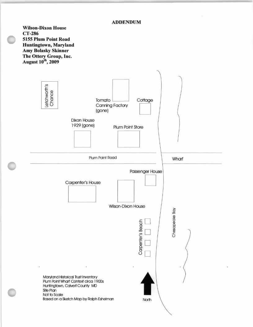
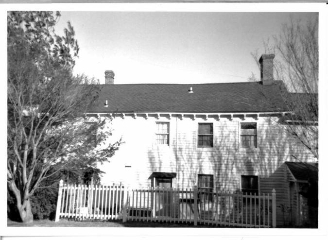
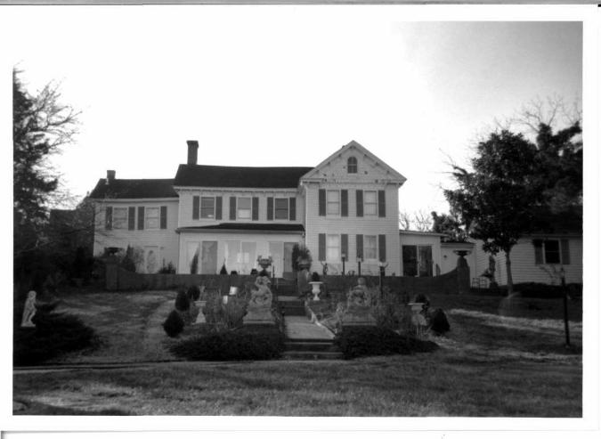
The Wilson-Dixon House is located at 5155 Plum Point Road; it is the last property to the south before Plum Point Road ends. The Victorian house was built in 1860 by Samuel B. Wilson, wharf master, post master, and store owner. A later addition was constructed circa 1899 by the Joseph Dixon Sr. In addition to the Wilson-Dixon House, the property originally was comprised of approximately three acres, including the Plum Point Store, the 1927 Dixon House, Plum Point Wharf, Warehouse, and Passenger House. In 1985 the three acre parcel was divided into two separate parcels, the circa 1860s house is located on the southern parcel (Tax Map 19 Parcel's 87 and 90) and an undocumented 1920s house is located on the northern parcel (Tax Map 19 Parcel 77. ' The Wilson-Dixon House is bound by the Chesapeake Bay to the east, the Carpenter family Farm, Bellcar, to the west and south, and 1920s house, Parcel 77 to the north.
DESCRIPTION
The Wilson-Dixon House is set back from Plum Point Road approximately thirty feet and from the Chesapeake Bay approximately one hundred and fifty feet. The house is located on a slight hill with the land sloping steeply north to Plum Point Road and gradually east to the Chesapeake Bay. The house is completely surrounded on its north and west elevations by two fences. The north is bound by a tall wood fence clad with ivy. The Wilson-Dixon House is accessed from the north by a paved, asphalt driveway. There is an ornate gate on the north side of the parcel to the east past the driveway. The arched gate is wrought iron with floral and scroll ornamentation. The gate appears mostly decorative, though functional, and is not accessible from the north driveway. The gate leads to the front, east yard and garden of the Wilson-Dixon House.
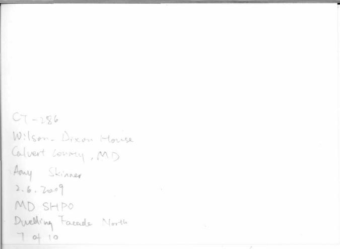
The Wilson-Dixon House has three building periods; a side-hall, single-parlor dwelling on the south that dates to 1860, constructed by Samuel B. Wilson, a cross-gable addition with Victorian
1 A 2 lA acre parcel was purchased by Samuel Wilson from John M. and Susan Broome in 1869. Calvert County Land Records Deed SS 1: 310. The 1920s house is located at 5160 Plum Point Road, on that subdivided land, Tax Map 19, Parcel 77. The original Wilson-Dixon land was subdivided by Richard and Jeannette Stagg in 1985. Calvert County Land Records Deed ABE 35: 888. Parcel 77 may have been the original location of the passenger house before the Chesapeake Wharf Company moved it south in 1893. For whom the 1920s house was built is unknown. 2 The Wilson-Dixon House was previously documented in 1979 with a Maryland Inventory of Historic Places form. The following paragraphs expand and update that original survey form; for additional information regarding original materials and the interior reference the 1979 form. Stinson, Merry MIHP Form CT-286 "Wilson-Dixon House" 1979.

ADDENDUM Wilson-Dixon House CT-286 5155 Plum Point Road Huntingtown, Maryland Amy Bolasky Skinner The Ottery Group, Inc. August 10th, 2009
characteristics that was built at the north end after 1899 by Joseph Dixon Sr., and a two-story frame kitchen that was added at the south end of the house in the twentieth century. The original 1860s wing was a side-hall, single parlor dwelling that was two-story, three-by-two bays. The wing has a steeply pitched, side-gable roof clad with asphalt shingles and slightly overhanging eaves. There are scrollwork brackets along the wide wood cornice. There is an interior end, brick chimney with a corbelled cap on the south elevation. The wing is of wood-frame construction with a brick foundation. The exterior is clad with a secondary sheathing of vinyl siding, although it was clad originally with lapped clapboards. The fenestration is symmetrical with single, one-over-one, double-hung wood sash replacement windows on the east facade and single, six-over-six, double-hung wood sash replacement windows on the west elevation. Windows on the east facade are flanked by louvered wood shutters. A modern, fully-enclosed, full-length, one-story, hip-roof porch replaces an earlier hip-roof that was supported by turned balustrade posts with scroll tracery in the corners. The modern replacement is clad with vinyl siding and has three, double, sliding glass doors across its facade. There is a secondary entrance to the 1860s house block in the north bay of the west elevation. The door has a shed-roof entry porch that is supported by one wood post.
In 1899 Joseph Dixon Sr. purchased the Wilson property and built a two-and-a-half story, two-by-four bay cross-gable addition to the north. The original 1860s wing was wrapped into the new cross-gable addition creating a five-by-three bay dwelling. The 1899 cross-gable addition has a steeply pitched roof clad with asphalt shingles. There is a central, brick stretcher chimney with a corbelled cap at the intersection of the cross-gable's roofline. The gable ends have a wide cornice with partial returns. The pediment is clad with wood fish scale shingles and has an arched, two-over-two, double-hung wood sash window in its peak. Wood scrollwork brackets line the wood cornice on the side-gable and gable ends. The addition is of wood-frame construction with a brick foundation. The exterior is clad with a secondary sheathing of vinyl siding; the 1899 addition was originally clad with German siding. Fenestration is symmetrical on the facade with single one-over-one, double-hung wood sash, replacement windows flanked by louvered wood shutters. There is a modern, fully-enclosed, full-length, one-story, hip-roof porch across the north elevation. The modern porch is clad with vinyl siding and has two, double, sliding glass doors across its facade.
The modern north porch connects to a one-story, two-by-two bay garage by a one-story, one-by-one-half bay enclosed walkway. The enclosed walkway has a shallow pitched, side-gable roof clad with asphalt shingles. The exterior is clad with vinyl siding. The garage attaches to the enclosed walkway at the north elevation. The garage has a steeply pitched, side-gable roof that is clad with asphalt shingles. The exterior is clad in modern, vinyl siding. There are two, vinyl paneled garage doors on the west facade. There are two, double-hung wood sash replacement windows flanked by louvered wood shutters on the east elevation.
A two-story, two-by-two bay kitchen wing was added to the south elevation of the main house at the 1860 house block. Unlike the main house the kitchen wing has no Victorian ornamentation. The wing

ADDENDUM Wilson-Dixon House CT-286 5155 Plum Point Road Huntingtown, Maryland Amy Bolasky Skinner The Ottery Group, Inc. August 10th, 2009
has a shallowly pitched side-gable roof clad with asphalt shingles and overhanging eaves. There is an interior end, brick chimney with a corbelled cap on the south elevation that seemingly replaced the original stove flue that "rose from the south end." The kitchen wing is of wood-frame construction with a brick foundation. The exterior is clad in a secondary sheathing of vinyl siding. Fenestration is symmetrical with one-over-one, double-hung wood sash replacement windows. The windows are flanked by louvered wood shutters. There is a modern, glazed, vinyl entry door in the north bay of the east facade.
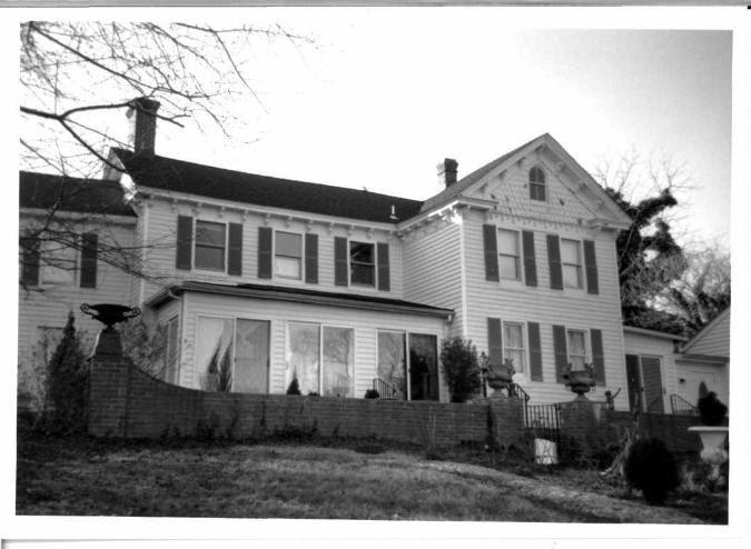
The east facade of the Wilson-Dixon House is surrounded on the south by large trees and plantings providing privacy. A larger formal garden spans the main facade to the Bay. There is a low, brick knee wall in front of the east facade. The knee wall curves to meet the end-piers. Each pier has a garden urn atop its cap. From the house, three brick stairs lead to a brick walkway with step downs to the lower, east yard by the Bay. The walkway is flanked by formal plantings, sculpture, and garden urns. The east facade historically was the Wilson-Dixon House's "front" and provides a formal and grand entry onto the property from the water.
To the southeast of the Wilson-Dixon House is a secondary dwelling. The building, originally believed to have been a garage, is a two-story, two-by-two bay dwelling with a shallowly pitched front-gable roof clad with asphalt shingles. The roof has overhanging eaves and a boxed cornice with partial returns. The dwelling's exterior is clad in a secondary sheathing of vinyl siding and has asymmetrical fenestration. The north facade has a pair of modern, vinyl paneled entry doors on the first story. There is a large, arched transom-like window atop the main entry doors in the west bay. There are no windows on the first story. The east bay of the north facade has a pair of sliding double glass windows flanked by single, one-over-one, fixed vinyl windows. The east elevation has a pair of vinyl sliding glass doors on the first story. The doors lead to a low brick patio that wraps the east elevation and north facade. A pair of sliding, double glass windows are flanked by single, narrow, one-pane fixed vinyl windows on the second story. The south elevation has two, multi-light vinyl windows in what may have been retractable garage door bays. There is a ribbon of six, one-light, fixed vinyl windows. The dwelling's original use is unknown as is its current function; however, the first story appears to be partially an interior greenhouse, in the southeast bay with a sitting room in the northwest bay. The second story appears to have been converted into a secondary dwelling.
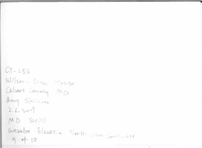
There is a one-story, one-by-one bay gazebo to the southeast of the house directly east of the secondary dwelling. The gazebo has a shallowly pitched pyramidal roof clad with asphalt shingles. There are overhanging eaves and a wide, wood cornice. The gazebo is of wood-frame construction with a raised foundation clad with lattice work. There is framing and screening on every elevation. The gazebo is surrounded by sand on the north, east and south elevations and grass on the west. Two wooden stairs lead to the entrance on the west facade. There is a wood screen door with screened panels on the west facade.

ADDENDUM Wilson-Dixon House CT-286 5155 Plum Point Road Huntingtown, Maryland Amy Bolasky Skinner The Ottery Group, Inc. August 10th, 2009
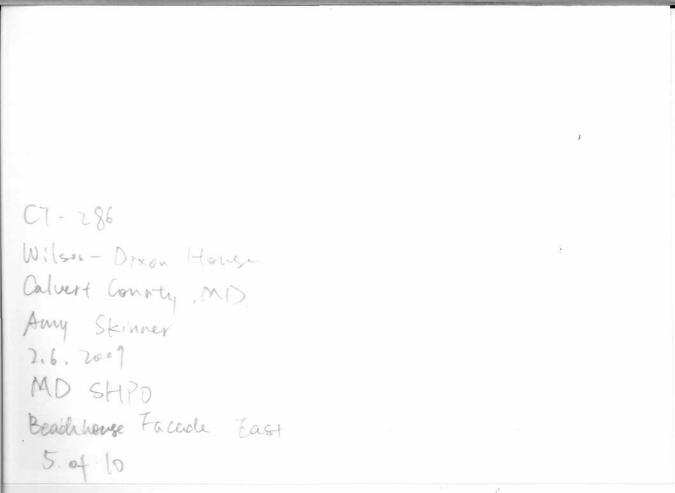
To the north of the gazebo, approximately thirty feet from the Chesapeake Bay is a modern, beach / bath house that was built in 1997. The building is two-story, two-by-one bays with a steeply pitched side-gable roof clad with asphalt shingles. There are two extremely steeply pitched, front-gable dormers; one on the east facade and one on the west elevation. The dormers have wide cornice trim; the pediments are clad with vinyl siding. The beach / bath house is of wood-frame construction and the foundation is clad with faux stone. There is a two-story porch on the east facade. The porch is supported on the first story by two, square posts. The second story is enclosed with a vinyl balustrade. The fenestration is asymmetrical. There is a projecting bay window in the south bay of the facade. It has one-fixed vinyl window flanked by a one-over-one, double-hung sash window. There is a four-over-four, double-hung vinyl sash window to the north of the vinyl glazed entry door. On the exterior of the rear west elevation there is a metal spiral staircase that provides access from the first story to the second story. The spiral staircase meets the second story at a wood porch landing. There is an exterior stone clad chimney on the west elevation. The specific function of the building is unknown, however, due to the inclusion of a small kitchenette and bathroom it appears the beach / bath house provides shelter and amenities for Wilson-Dixon House visitors relaxing near the Bay.
ADDENDUM Wilson-Dixon House CT-286 5155 Plum Point Road Huntingtown, Maryland Amy Bolasky Skinner The Ottery Group, Inc. August 10th, 2009
Section 8. SIGNIFICANCE
Prepare a one-paragraph summary statement of significance addressing applicable criteria, followed by a narrative discussion of the history of the resource and its context. (Fore compliance projects, complete evaluation on a DOE form-see manual.)
SUMMARY
Calvert County encompasses a narrow piece of land between the Chesapeake Bay to the east, and the Patuxent River to the west and south. It is surrounded by water on all sides except to the north where it adjoins Anne Arundel County. Calvert County is the smallest of the five counties of Southern Maryland and fourth oldest in Maryland. Although the County once stretched to the headwaters of the Patuxent River in modern-day Frederick County, it now measures only 218 square miles, making it the smallest of all Maryland counties. High cliffs characterize Calvert County's bay side shoreline. Conversely, the numerous creeks along the Patuxent River facilitated maritime traffic, servicing the County's richest agricultural lands.
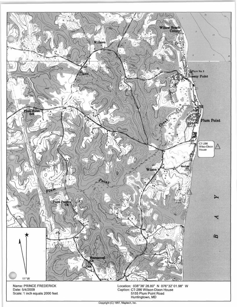
Wilson Road runs parallel to the Chesapeake Bay and is bound to the north by Plum Point Road and to the south by Emmanuel Church Road. Huntingtown and Prince Frederick are the two largest towns in close proximity. The Wilson Dixon House, is located on a stretch of road between the Wilson Road and Plum Point Road intersection to the north and the Wilson Road and Emmanuel Church Road intersection to the south.
Ornate and modest twentieth century homesteads, tobacco barns, farm outbuildings, and tenant houses are linked by Wilson Road, which has been a prominent local thoroughfare since the mid-nineteenth century. Other significant landscape features along Wilson Road in the mid-nineteenth century include a steamship landing, a wharf and a windmill located at Plum Point. Dunn Road is the only other road that dates to the mid-nineteenth century. Dunn Road branches off Wilson Road and originally extended all the way east to the Bay and as far west as the Freeland properties.5 Today, Dunn Road ends at Suit's Chance, a farm in a County Agricultural Preservation District. In historic maps dating to the mid-nineteenth century, many large farm properties stand along Wilson Road including Letchworth's Chance (CT-25), the Ireland Farm (CT-26), the Owen H. Jones Farm (CT-476), the Baden-Anderson Farm (CT-27), and a modest side-parlor house known as the Plank House (CT-257).7
3 Stein, Charles Francis. "A History of Calvert County." Schneidereith & Sons: Baltimore, 1977: 1. 4 1865 Martenet Atlas of Maryland. 5 Morris Suit Interview. Oral History Interview with Amy Bolasky Skinner for Wilson Road Historic Context Study, 10 March 2009. 6 Morris Suit Interview. 7 A.D. Bache, United States Coast Survey, Western Shore of Chesapeake Bay, 1847. Available at the Calvert Marine Museum.

ADDENDUM Wilson-Dixon House CT-286 5155 Plum Point Road Huntingtown, Maryland Amy Bolasky Skinner The Ottery Group, Inc. August 10th, 2009
The Wilson Road area can be found on maps dating to the seventeenth century. Augustine Hermann placed Plum Point on his map in 1675, and depicted a number of plantations along the shores of the Chesapeake Bay and the Patuxent River. Later, in the mid-nineteenth century, the Martenet map shows Plum Point in excellent detail. In 1892, the United States Geological Survey depicts Plum Point and Wilson Road, and subsequent modifications to this map by the USGS reveals various changes on the landscape, including the addition to new structures and the alteration of roadways, including Plum Point Road. For example the 1910 USGS Topographic Map shows three improved roads extending east from Wilson Road toward the Bay.8 The northernmost road is Patience Place. The Ireland family farmstead (CT-26) is located along this road. Although the property and buildings were visible in the mid-nineteenth century, Patience Place does not appear mapped until about the early-twentieth century.9 The next road to the south is Angelica Drive. The Owen H. Jones family farm (CT-476) is located at the end of this road. The Owen H. Jones farm can trace its roots to the Hance and Wilson families back to the mid-nineteenth century. The southernmost road is Camp Kaufmann Road. The Agnes Buckler House (CT-478), visible on the 1910 topographic map, is located at the end of Camp Kaufmann Road on a dirt trace.
The most significant change to the area occurs in the mid-twentieth century. The 1932 US Geological Survey Topographical Map shows subdivisions and new roads along Wilson Road as Calvert County connects with surrounding counties.10 Letchworth's Chance (CT-25) is subdivided and the Neeld Estates appears with many private properties clustered along the Bay's shoreline. Additionally, on this map Dunn Road no longer connects to Stinnett Road. Since the 1930s Dunn Road has only been accessible from Wilson Road. A new road, branches east off Wilson Road, south of Patience Place. Paul Hance Road is the location of the original Paul Hance House (CT-474) as well as the former H. Oscar Bowen House (CT-473). Although they no are longer standing, both properties were visible in the mid-nineteenth century.
The last major alteration to the roads connecting to Wilson Road was documented in the 1939 Topographic Map surveyed by the US Department of Agriculture and also appears on the current Topographic Map for Wilson Road.11 The map shows the original northern curvature of Plum Point Road; however, it also demonstrates the changed and improved Plum Point Road running due east towards the Bay and the wharf ruins. The modern road takes this path.
8 Topographic Map of Prince Frederick, Maryland Quadrangle, United States Geological Survey, 1900. Available at the Calvert Marine Museum. 9 Topographic Map of Prince Frederick, Maryland Quadrangle, United States Geological Survey, 1900. Available at the Calvert Marine Museum. 10 Topographic Map of Prince Frederick, Maryland Quadrangle, United States Geological Survey, 1932. Available at the Calvert Marine Museum. 11 Topographic Atlas of Maryland Counties of Calvert Charles and St. Mary's, United States Department of Agriculture, Soil Conservation Service, 1939. Available at the Calvert Marine Museum and Topographic Map of Prince Frederick, Maryland Quadrangle, United States Geological Survey, 1993. Available through Terrain Navigator.

ADDENDUM Wilson-Dixon House CT-286 5155 Plum Point Road Huntingtown, Maryland Amy Bolasky Skinner The Ottery Group, Inc. August 10th, 2009
The history of the Wilson Road area can be defined by two overarching themes: Agriculture and Transportation. The movement of goods, such as tobacco, was facilitated by water transportation that linked individual plantations to shipping centers in the County and around the Chesapeake Bay. Later, in the eighteenth and nineteenth centuries, the development of inland road networks became essential to the commercial success of Calvert's plantations.
Water transportation had always been the most effective means for shipping and receiving goods throughout Calvert County. Until the twentieth century roads in Calvert County were rural and unimproved; steamships took goods to places like Baltimore to be sold or shipped overseas. "The creation of regular commercial and passenger service on the Bay helped boost the local economy. The most successful of the early attempts to create a regular shipping line in Calvert County was established by Captain George Weems in 1817. The Weems Steamship Line was the principal carrier between the Port of Baltimore and southern Maryland."12
In the Wilson Road vicinity there was a wharf at Plum Point. The first wharf at Plum Point was located 250 to 300 feet north of the present Plum Point Road. It was relocated further south in 1893 and rebuilt three quarters of a mile long, "L-shaped" and one of the longest on the Chesapeake Bay. The location of the wharf was one catalyst for development along Wilson Road. Areas around the wharf became gathering places where locals could watch the ships load and use the private beaches. Some families allowed the public to park on their land while others created private beach cottages for rent.13 The Wilson Store (later the Dixon Store) was a combined store and post office often frequented by locals and visitors alike. Plum Point was a bustling area along Wilson Road until August of 1933 when a hurricane devastated the farms and the crop along Wilson Road. The hurricane demolished the warehouse as well as most of the pier.
Wilson Road's association with agriculture can be seen in the landscape and found in the local relationships of residents. One result of the reliance on tobacco is seen in the area of Calvert County along the Bay, notably a lack of central towns, as well as "the significant role that elite planters had in the political and social life in the community, and the complex interrelationships between the various classes and races living together within the community."14 Wilson Road, an example of the broader characterization of Calvert County, was a prime location for tobacco farming, a "combination of favorable soil and topography, good river transportation and fortunate economic considerations contributed to Calvert County's being overwhelmingly agricultural from its beginning, with tobacco the
12 Dames & Moore, "Historic Sites Context Study and National Register Evaluation." The Calvert County Historic District Commission, 1995:4 and Stein 1977:169. 13 Eshelman & Associates, "Calvert County Steamboat Wharves and Landings: Architectural Level Survey and Inventory." The Calvert County Historic District Commission, 1996 and Carpenter, Evelyn B. "A History of Carpenter's Beach." Calvert County Marine Museum: Unpublished manuscript, 1984. 14 Kulikoff, Allan, "Tobacco and Slaves." University of North Carolina: Chapel Hill, 1986 and Dames & Moore 1995: 5.
ADDENDUM Wilson-Dixon House CT-286 5155 Plum Point Road Huntingtown, Maryland Amy Bolasky Skinner The Ottery Group, Inc. August 10th, 2009
principal cash crop."15 Families settled along Wilson Road to live and grow tobacco. Wilson Road has no town center nearby with the closest town being Huntingtown, 9 miles to the northwest, or Prince Frederick 4.5 miles to the southwest. Being in such close proximity, all the families along Wilson Road socialized with, went to school with, worshipped with and often married one another. Many of the current residents along Wilson Road have surnames such as Bassford (later Carpenter), Wilson, Hance, Jones, Ireland. The expansive layout of family farms along the landscape of Wilson Road highlights the way Calvert County was settled as a result of tobacco farming. Tobacco would remain the chief crop and one of the defining features of the County until well into the late twentieth century.
After World War II with improvements to transportation a "dramatic change to the character and landscape of Calvert County" occurred.16 The area is now linked to the Washington-Baltimore metropolitan area and real estate prices have increased while demands for tobacco have decreased. With properties along Wilson Road no longer focused on tobacco farming tenants have moved away and dwellings are vacant. Many family homesteads have been subdivided to provide land and houses for current and future generations.
Despite modern changes to Calvert County, the agricultural landscape along Wilson Road is not so altered that one cannot discern the historic character. The Wilson Road area can be characterized as a rural farming community whose origins are firmly rooted in the production of tobacco. From its first settlements at places like Angelica in the 1600s, farming was the primary economic focus that helped establish the community along Wilson Road. In many ways, the community remains largely unaltered, with descendants of nineteenth century settlers still living in the area today, namely the Degges at Letchworth's Chance (CT-25), the Carpenter's at Bellcar (CT-472), the Ireland farm (CT-26), the Hance's at Paul Hance Farm (CT-474), the Hance/Jones' at Owen H. Jones Farm (CT-476), and the Buckler's at Agnes H. Buckler Farm (CT-478 and S. Chester Buckler Farm CT-492). These families continue to leave their legacy along the landscape through the buildings, structures, and vistas that have historically characterized Calvert County.
The Wilson family history in Calvert County began with James Wilson prior to 1652. The Wilson family possessed a flair for military matters; many were officers in the Calvert County Militia and some fought in the American Revolution.17 A Wilson family descendant, Samuel Wilson, purchased property along Plum Point Road first in 1863 and again in 1869.18 Known to the community as "Captain Sam," Samuel Wilson owned a fleet of sailboats for shipping between Plum Point and the ports of Baltimore. Wilson built the store, Plum Point Store, also known as Wilson's Store, on the northern parcel of
15 Dames & Moore 1995:4. 16 Dames & Moore 1995: 17. 17 Stein 1977: 335. 18 Samuel Wilson acquired 2 % acres of property from John M. and Susan M. Broome (sellers for the Morsell Family) in 1869. Calvert County Land Records Deed SS 1: 310 and Eshelman, Ralph. "Plum Point: A Short History." Calvert County Marine Museum: Unpublished manuscript, c 1980s.
ADDENDUM Wilson-Dixon House CT-286 5155 Plum Point Road Huntingtown, Maryland Amy Bolasky Skinner The Ottery Group, Inc. August 10th, 2009
property possibly incorporating the original warehouse that was on the property.19 He also owned the post office at the end of Plum Point Road.20 An entrepreneur, Samuel became wharf master when the steamboat wharf was built in the mid-nineteenth century. He built the first section of a house on the parcel to the south that he purchased in 1863 from Richard Hance. Samuel Wilson married Henrietta Marieta Hance (called Maria H. in the Deeds 1845-1919), sister of Richard. She is buried on Angelica, a farm today known as Owen H. Jones Farm (CT-476) off of Wilson Road, beside her sister Rebecca Hance (1840-1921). Samuel and his wife had one son, John (Jack) Wilson.
In 1878 Samuel Wilson built a house for his son John (Jack) Wilson and his bride Elizabeth Bassford.23
This date was given by Elizabeth Bassford's relative Evelyn Carpenter; however, other sources place the date of the original house's construction around the 1860s.24 Jack died only two years into their marriage of pneumonia the year their daughter Sallie was born. Elizabeth (Bassford) Wilson remained a widow for eleven years before marrying neighbor, and husband of her deceased sister, Thomas L. Carpenter.
Joseph Dixon Sr. along with his wife Hester O. (Cox) Dixon26 purchased the property from Samuel B. Wilson and wife, (Henrietta Marieta) Maria H. in 1899.27 Joseph Dixon Sr. had been a clerk for Samuel Wilson first as a store "on the intersection of Route 2/4 and Ponds Wood Road then at Plum Point Store."2 Joseph Sr. and Hester had three living children; Joseph Dixon Jr. (born April 19, 1893), James Norval Dixon, Sr. (born April 20, 1894), and Samuel Dixon (born April 1896).
Joseph Dixon Sr. was the storekeeper for Plum Point Store and post master while his wife Hester ran a boarding house. In 1927 their son Samuel H. Dixon and his wife Hilda E. Dixon built a home on the north side of the property to the south of the Plum Point Store. Samuel H. Dixon "ran party boats from the old steamboat wharf." The old Wilson home was used as a boarding house for fisherman,
19 Eshelman, Ralph. "Plum Point: A Short History." 20 The post office and store may have been housed within the one store building. Carpenter, Evelyn B. "A History of Carpenter's Beach." Calvert County Marine Museum: Unpublished manuscript, 1984 and Eshelman, Ralph. "Plum Point: A Short History." 21 Carpenter, Evelyn B. "A History of Carpenter's Beach." 22 Calvert County Land Records Deed SS 1: 308 and Eshelman, Ralph. "Plum Point: A Short History." 23 Carpenter, Evelyn B. "A History of Carpenter's Beach." 24 Carpenter, Evelyn B. "A History of Carpenter's Beach." and Stinson, Merry MIHP Form CT-286. 25 Elizabeth Bassford (related to the Ireland Family) and sister of Amelia (Thomas Carpenter's first wife) married Samuel Wilson's son, John (Jack) Wilson in 1878. In 1891 Elizabeth married Thomas Carpenter and they had one son, Oscar. Oscar and his wife Evelyn B. Carpenter had three girls and resided at "Bellcar," a farm adjacent to the west of the Wilson-Dixon property along Plum Point Road. 26 Joseph Allison Dixon Sr. Born September 5*, 1861-Died February 5, 1943. Hester O. Cox Dixon Born October 16, 1863-Died June 1949. They were married on December 9, 1890. 27 Calvert County Land Records Deed TBT 5: 558 28 Oral History Transcript. "Plum Point Store" Mr. and Mrs. James Norval Dixon Jr. by R.E. Eshelman. August 1985. 29 Eshelman, Ralph. "Plum Point: A Short History."

ADDENDUM Wilson-Dixon House CT-286 5155 Plum Point Road Huntingtown, Maryland Amy Bolasky Skinner The Ottery Group, Inc. August 10th, 2009
weekenders, and summer boarders; it could house up to twenty people at a time.30 Joseph Sr. partnered with his son, J. Norval Dixon Sr., in 1933. J. Norval Sr. continued running the store and renting it from his brother, Samuel, upon their parents' deaths in the 1940s. After the death of J. Norval Dixon Sr. in 1954, his wife, Lillian B. closed the store building and moved the store to the back porch of her home.32
Lillian inherited the property until her death in 1972. In 1973 J. Norval Dixon Jr., their son, and his wife, Virginia Dixon inherited the property and ran Lillian's store.33 He sold the property due to illness in 1979 to Richard Stagg and his wife Jeannette.34 In 1985 Donald Mclntyre purchased the property from the Staggs.35 Mclntyre sold the property to the present owners, Kenneth and Sudha Haley in 1988.36
The beaches along the Chesapeake Bay at Plum Point and Wilson Road were all private. The Dixon family allowed visitors to park on their property and use the beach in front of their home and store for a fee. Joseph Dixon Sr. charged 30 cents in the 1930's to park.37 Visitors who wanted to fish and crab off of the wharf were taken by Joseph Dixon Sr. in his rowboat for 25 cents.38 After the death of their brother in 1954, Samuel and Joseph continued to provide parking for beach visitors. Samuel charged for parking on the north section of Plum Point Road, while Joseph charged for parking on the south side. By 1954 cars were charged 50 cents. By 1975 parking had increased to $1.00. As the beach was private, the Dixon Family kept the beach segregated, denying African Americans use of the parking area and shore.39
30 Eshelman, Ralph. "Plum Point: A Short History." and Eshelman, Ralph MIHP Form CT-287 "Plum Point Wharf 1996. It is unclear how long the Dixon's lived in the old Wilson before opening up the dwelling to the boarders and renters. By the late 1970s the house was vacant, in extreme disrepair and in need of a major renovation. 31 The ownership of the property passed from their parents Joseph A. Dixon and Hester O. Dixon to the youngest son, Samuel Hezekiali Dixon in 1927. Calvert County Land Records Deed AAH 17: 448. 32 The store stayed in the Dixon family until 1954 when it was moved to a closed in porch on the Dixon homestead built in 1927 just west of the store. Eshelman, Ralph. "Plum Point: A Short History." 33 Eshelman, Ralph. "Plum Point: A Short History." An interesting anecdote was related by Robert Neeld to R.E. Eshelman in 1979. Neeld states that in 1946 Samuel Mason Dixon (1924-1967) was talking to Hance family ancestors who once owned property at Plum Point. The Hances stated that during the Civil War two confederate officers were in the Plum Point Store when they were told Union men were in the area. They quickly changed clothes in the attic of the store and hid their swords under the floor boards. Sam in searching the attic found two swords, now owned by James Norval Dixon III of Plum Point. 34 Oral History Transcript. "Plum Point Store" and Calvert County Land Records Deed ABE 247: 44. 35 Calvert County Land Records Deed ABE 350: 83. 36 Calvert County Land Records Deed ABE 460: 203. 37 Oral History Transcript. "Plum Point Store". 38 Eshelman, Ralph MIHP Form CT-287. 39 Oral History Transcript. "Plum Point Store". J. Norval Dixon Jr. also mentions an altercation where "During the city riots after Martin Luther King's assassination, three bus loads of blacks and whites from Baltimore came down and overran the beach-some stripped naked, many threw gravel, beer bottles, cans, etc at the rest of folks on the beach and at owners." In addition the NAACP at one time brough suit against the Dixons for refusing to allow blacks in the beach.
ADDENDUM Wilson-Dixon House CT-286 5155 Plum Point Road Huntingtown, Maryland Amy Bolasky Skinner The Ottery Group, Inc. August 10th, 2009
STATEMENT OF SIGNIFICANCE
The Wilson-Dixon House is significant architecturally, as a nineteenth century house with Victorian characteristics. Although the associated commercial buildings have long been demolished, the Wilson-Dixon House remains an example of a commercial era when residents of a community had many occupations and responsibilities. The property is also significant to Calvert County's rural-agricultural heritage as an example of a shipping wharf that provided the sale of wares (namely tobacco) from Plum Point to the ports of Baltimore.
ADDENDUM Wilson-Dixon House CT-286 5155 Plum Point Road Huntingtown, Maryland Amy Bolasky Skinner The Ottery Group, Inc. August 10th, 2009
Maryland Historical Trust Inventory Plum Point Wharf Context circa 1900s Huntingtown, Calvert County MD Site Plan Not to Scale Based on a Sketch Map by Ralph Eshelman

ADDENDUM Wilson-Dixon House CT-286 5155 Plum Point Road Huntingtown, Maryland Amy Bolasky Skinner The Ottery Group, Inc. August 10th, 2009
Maryland Historical Trust Inventory No. CT-286 Wilson-Dixon House Huntingtown, Calvert County MD Site Plan Not to Scale House, 5155 Wilson Road
Name: PRINCE FREDERICK Date: 5/4/2009 Scale: 1 inch equals 2000 feet
Location: 038°36' 26.80" N 076°32'01.98" W Caption: CT-286 Wilson-Dixon House
5155 Plum Point Road Huntingtown, MD


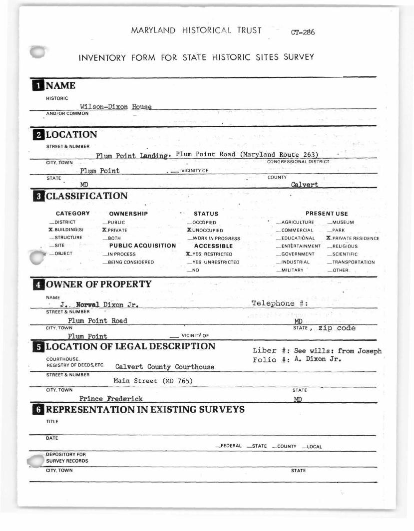
MARYLAND HISTORICAL TRUST CT-286
INVENTORY FORM FOR STATE HISTORIC SITES SURVEY
NAME HISTORIC
Wilson-Dixon House _ _ AND/OR COMMON
LOCATION STREET & NUMBER
Plum Point Landing' P l u m Point Road (Maryland Route 263) CITY. TOWN . CONGRESSIONAL DISTRICT
Plum P o i n t VICINITY OF STATE . COUNTY
MP , Calvert
CLASSIFICATION
CATEGORY OWNERSHIP STATUS PRESENT USE —DISTRICT —PUBLIC —OCCUPIED ' —AGRICULTURE —MUSEUM
X-BUILDING(S) X.PRIVATE XUNOCCUPIED —COMMERCIAL —PARK
—STRUCTURE —BOTH —WORK IN PROGRESS — EDUCATI&NAL ^PRIVATE RESIDENCE
—SITE PUBLIC ACQUISITION ACCESSIBLE —ENTERTAINMENT —RELIGIOUS
—OBJECT —IN PROCESS X_YES: RESTRICTED —GOVERNMENT —SCIENTIFIC
—BEING CONSIDERED —YES: UNRESTRICTED —INDUSTRIAL —TRANSPORTATION
_ N O —MILITARY —OTHER:
OWNER OF PROPERTY NAME
J . . Nonral Dixon J r . ' T e l e p h o n e # : STREET & NUMBER
Plum Po in t Road MP CITY.TOWN STATE , z i p c o d e
Plum Po in t — VICINITY OF
LOCATION OF LEGAL DESCRIPTION Llber ,, SM u l l l s , froK Joseph COURTHOUSE. F o l i o # : A. Dixon J r . REGISTRY OF DEEDS,ETC. C a l v e r t County Courthouse STREETS. NUMBER
Main S t r e e t (MD 765) CITY. TOWN STATE
Prince Frederick MP
REPRESENTATION IN EXISTING SURVEYS TITLE
—FEDERAL —STATE —COUNTY —LOCAL
DEPOSITORY FOR SURVEY RECORDS
CITY. TOWN STATE I

CT-286
DESCRIPTION CT-286
CONDITION CHECK ONE CHECK ONE
—EXCELLENT XDETERIORATED X-UNALTERED 3LORIGtNAL SITE
_GOOD _RUINS -ALTERED - M O V E D DATE
—FAIR —UNEXPOSED
DESCRIBE THE PRESENT AND ORIGINAL (IF KNOWN) PHYSICAL APPEARANCE
English boxwood planted in the 1930,s accents the Wilson-Dixon house's bay side. The sweeping lawn ends at a sandy beach. One entrance to the house faces the bay, while the other faces Plum Point Landing road, which skirts the property's north side.
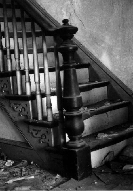
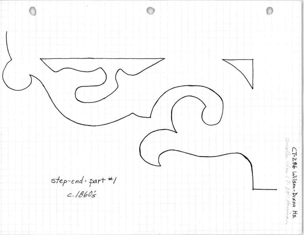
The original section of this two-story, frame, Victorian house consists of a side-hall single-parlor dwelling facing the Chesapeake Bay. This part dates from the 1860's. It is covered with simple lapped clapboards. The main entrance, with sidelights and transom, features chamfered posts. The stair includes a heavy, turned newel post, turned balusters, and decorated step-ends. A chimney at the south end serves fireplaces on either floor. Raised, applied panels decorate the mantels.
After 1899, a four bay by two bay cross-gable addition running east-west, was built at the north end. This provides a large parlor on the east, and an entrance hall and smaller parlor on the west. The main parlor door leading into the hall retains its original combed and woodgrained paint. The smaller parlor is reached through a door under the stair in section #1. The trim in this room in unpainted. A chimney situated on the common wall between the parlors served four fireplaces— two on either floor. The two east mantels and the new ten-panel front door display Eastlake-like carvings. The two west mantels are supported by simple curved brackets.
The addition was covered with beveled "German"siding and lighted with 2/2 windu«^"% The new gables were decorated with rounded shingles and scrollwork brackets. Two porches were added, one across the north side of the addition and the other across the east side of the original section.
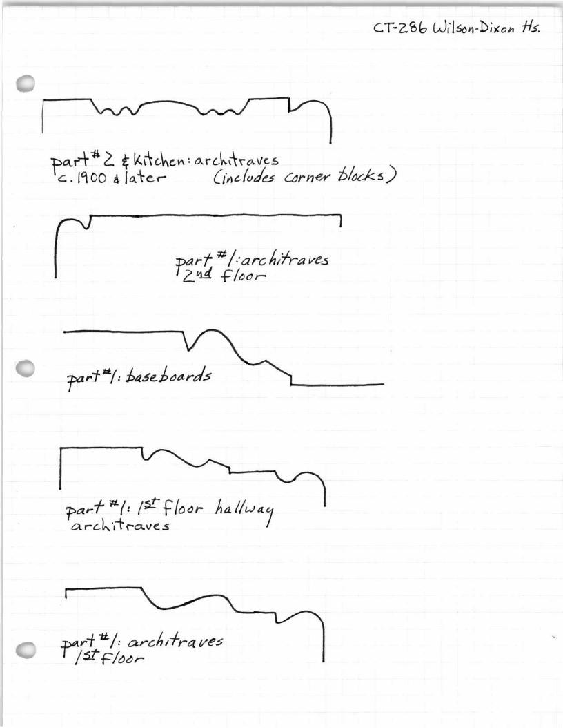
A two-story frame kitchen with a one-room plan was added at the south end of the house. A stove flue rises in the south end. A stair turning in the northeast corner leads to the second floor. Thin, beaded-board wainscoting trims the kitchen. 6/6 sash light the first floor, while 2/2 sash light the second floor. The architraves match those in the north addition.
The ©ntire house rests on a brick foundation. The asphalt-shingled roof is framed with circular-sawn rafters held by wire nails.
CONTINUE ON SEPARATE SHEET IF NECESSARY
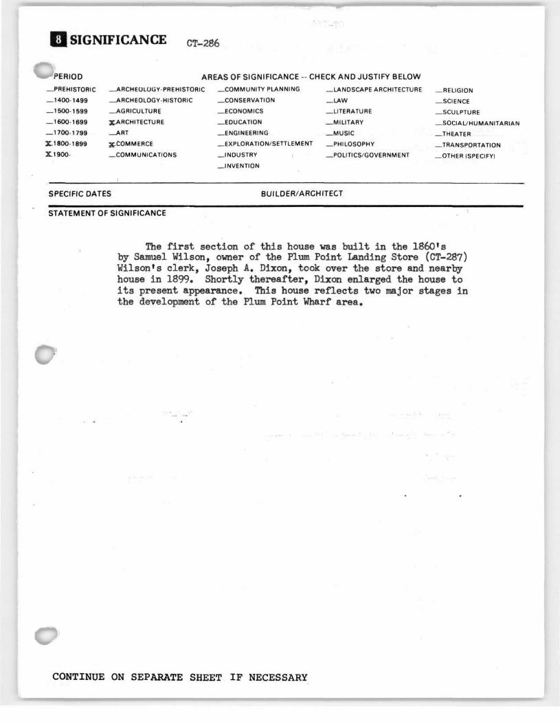
SIGNIFICANCE CT-286
PERIOD AREAS OF SIGNIFICANCE - CHECK AND JUSTIFY BELOW
—PREHISTORIC —ARCHEOLOGY-PREHISTORIC —COMMUNITY PLANNING —LANDSCAPE ARCHITECTURE —RELIGION
— 1400-1499 —ARCHEOLOGY-HISTORIC —CONSERVATION —LAW —SCIENCE
— 1500-1599 AGRICULTURE —ECONOMICS —LITERATURE —SCULPTURE
— 1600-1699 XARCHITECTURE —EDUCATION —MILITARY —SOCIAL/HUMANITARIAN
— 1700-1799 —ART —ENGINEERING —MUSIC —THEATER
X1800-1899 X-COMMERCE —EXPLORATION/SETTLEMENT —PHILOSOPHY —TRANSPORTATION
X.1900- —COMMUNICATIONS —INDUSTRY —POLITICS/GOVERNMENT —OTHER (SPECIFY)
—INVENTION
SPECIFIC DATES BUILDER/ARCHITECT
STATEMENT OF SIGNIFICANCE
The first section of this house was built in the 1860!s by Samuel Wilson, owner of the Plum Point Landing Store (CT-287) Wilson's clerk, Joseph A. Dixon, took over the store and nearby-house in 1899. Shortly thereafter, Dixon enlarged the house to its present appearance. This house reflects two major stages in the development of the Plum Point Wharf area.
CONTINUE ON SEPARATE SHEET IF NECESSARY
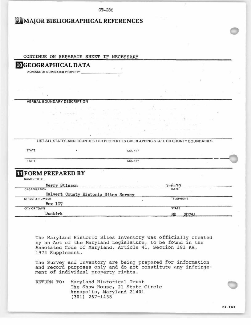
CT-286
MAJOR BIBLIOGRAPHICAL REFERENCES
CONTINUE ON SEPARATE SHEET IF NECESSARY
GEOGRAPHICAL DATA ACREAGE OF NOMINATED PROPERTY
;
VERBAL BOUNDARY DESCRIPTION :
i " • • • ' - - • . -
LIST ALL STATES AND COUNTIES FOR PROPERTIES OVERLAPPING STATE OR COUNTY BOUNDARIES
STATE • COUNTY
STATE COUNTY
FORM PREPARED BY NAME/TITLE
Merry Stinson 3-6-79 ORGANIZATION DATE
Calvert County Historic Sites Survey STREET& NUMBER TELEPHONE
Box 107 _____ CITY OR TOWN STATE
Dunktrk m 2Q25Z
The Maryland Historic Sites Inventory was officially created by an Act of the Maryland Legislature, to be found in the Annotated Code of Maryland, Article 41, Section 181 KA, 19 74 Supplement.
The Survey and Inventory are being prepared for information and record purposes only and do not constitute any infringement of individual property rights.
RETURN TO: Maryland Historical Trust The Shaw House, 21 State Circle Annapolis, Maryland 21401 (301) 267-1438
PS- 1 108

CT-286
Wilson-Dixon House
WILLS:
1959 - Joseph A. Dixon Jr. J. Norval Dixon, Jr.
J. Norval Dixon, Sr. Joseph A. Dixon, Jr. Sam Dixon
Joseph A. Dixon, Sr. Joseph A. Dixon, Jr. Lillie Dixon Sam Dixon
J. Norval Dixon, Sr.
AAH 25; 570
June 17, 1931 Chesapeake Wharf Co. to Jos. A. Dixon ^a.
1927: Almos D. Neeld vs Joseph A. Dixon Calvert County Circuit Court (plot in possession of J. Norval Dixon Jr.: I was unable to locate any record of this case in the Calvert County Courthouse in 1978— M. Stinson)
TBT 5: 558
June 19, 1899
Samuel B. Wilson Maria Wilson Joseph A. Dixon, Sr.
TBT 1: 396 & 398
April 6 & 24, 1893 ia.
(Samuel B.?) Wilson Chesapeake Wharf Co. Chesapeake Wharf Co.
S.B. Wilson had sold this -g- acre to Chesapeake Wharf Co.: deed burned in . 1882 Courthouse fire. Wharf Co. reserves right to use the present wharf until it finished building the new wharf. right to move "passenger house" right to move old material from the old wharf
This piece - ̂ a. - included the storehousa •,
SS 1: 310
February U, 1869 l a . 12 p .
John M. & Susan M. (wife) Broome Samuel B. Wilson
mentions storehouse (with the pr iv i lege of the bay shore)

CT-286 Wilson-Dixon House
Continued
SS 1: 308
October 13, 1863 la. Richard & Arrianna L. Hance Samuel B. Wilson
Plum Point Landing part of tract called Letchworth Chance $2500