addressing quality and usability of surface water bodies
TRANSCRIPT

ORIGINAL ARTICLE
Addressing Quality and Usability of Surface Water Bodiesin Semi-Arid Regions with Mining Influences
Patricia Gomes1 & Teresa Valente1 & Paulo Pereira1
Received: 17 May 2018 /Accepted: 19 September 2018 /Published online: 4 November 2018# Springer Nature Switzerland AG 2018
AbstractWater resources management has considerable importance, specifically in the context ofclimate change. This subject has introduced new challenges in semi-arid regions with waterquality problems, such as the Iberian Pyrite Belt, which is one of the largest metallogeneticprovinces in the world and one of the driest regions in Europe. Positioned in the Mediterraneancontext, the region has a high density of polymetallic sulphide mines that promote thedegradation of water systems. The present study aims to assess the water quality in the PyriteBelt, considering a total of 34 surface water bodies, including constructed reservoirs, perma-nent and ephemeral streams, and mining facilities with accumulated water (e.g., pit lakes andmining dams). The water samples were analysed for physico-chemical properties, includingfield parameters (pH, electrical conductivity), alkalinity/acidity, hardness, anions, and potentialtoxic elements. The results were used for hydrochemical classifications and the assessment ofsuitability for public uses. Statistical methods, such as hierarchical cluster analysis and nearestcentroid classifier, were used for grouping and evaluating the similarity between water bodies.Two groups were generated from the analysis: i) constructed lakes with alkaline and sodiumsignatures; and ii) waters suffering from the influence of mining wastes, e.g., showing highacidity, sulphate and metal contents. Therefore, the loss of water quality in the vicinity ofmines reflects the impact of acid mine drainage. The methodological approach used may beapplied to the integrated management of water resources in regions with mining influences andwhere it is necessary to combat drought and water scarcity scenarios.
Keywords Surface water . Reservoirs .Water quality .Mining contamination . Scarcity
Environmental Processes (2018) 5:707–725https://doi.org/10.1007/s40710-018-0329-0
* Teresa [email protected]
1 ICT, Institute of Earth Sciences, Pole of University of Minho, Universidade do Minho, Campus deGualtar, 4710-057 Braga, Portugal

1 Introduction
Water quality is a key resource for human living, especially for drinking and irrigationpurposes; thus, water is one of the most critical factors influencing human health (Zhanget al. 2012). Increasingly frequent and intense drought episodes, which are markers ofanticipated climate change, lead to water scarcity in semi-arid regions (Tiri et al. 2014). Thisis the case in the Mediterranean region, where these scenarios of water shortages have madewater quality a major concern.
Water quality is controlled by many natural and anthropogenic factors, as well as by thetype of land use (Suthar et al. 2010), such as mining activity. In fact, one of the most seriousproblems of environmental contamination worldwide is the formation of acid mine drainage(AMD) in mining regions (Valente et al. 2015). The process occurs when sulphide minerals areexposed to weathering, which generates acidity, sulphates and elements of toxicologicalconcern, such as metals (Gomes et al. 2016; Valente and Leal Gomes 2009). When thesecontaminated leachates reach river networks, the complete degradation of the aquatic ecosys-tems may occur. Additionally, if the impacted rivers drain into natural or artificial lakes, theprecipitation of metals can occur due to the increase in water pH promoted by the mixture.Moreover, this process leads to the accumulation of toxic elements on the lake bottom, whichcan reduce the storage capacity and the general functioning of the water reservoirs (Santistebanet al. 2015; Grande et al. 2015).
Therefore, water quality management is an issue of concern, especially in mining regionswith semi-arid climates. In such conditions, the construction of water reservoirs is one of themost common alternatives used to meet the increasing water demands required for agriculturalexpansion and growing populations (Santisteban et al. 2015). Nevertheless, in the context ofscarcity, all water bodies deserve careful management because they may be used to satisfypermanent or temporary water shortages, namely, for irrigation purposes. In these scenarios, asstated by Geller et al. (2013), even pit lakes that are storage facilities of very acidic water couldbe important for nature and wildlife as well as for public uses. This is the case for the IberianPyrite Belt (IPB) in southwestern Europe, one of the most important metallogenic provinces inthe world (Fig. 1). In this metallogenic province, which covers a large area of cross-borderterritory between Portugal and Spain, many abandoned mines prevail without correctivemeasures (Grande et al. 2013a; Rodrigues 2011); these mines generate AMD, and thusrepresent a potential focus related to water quality degradation.
Depending on the water uses, certain quality standards must be achieved in Portugal, e.g., inaccordance with the implementation of the Water Framework Directive (WFD). Therefore, theconcentration of toxic elements, such as metals and arsenic, cannot exceed legal limits, whichcould be a critical factor in the geological and mining backgrounds, such as in the IPB setting.
The general aims of the present study were to analyse the hydrochemical characteristics andevaluate the environmental quality of surface water in the IPB based on the legal standards fordrinking and irrigation. Taking into account the mining heritage of the region, one of thespecific objectives is related to the AMD process; specifically, the objective is to assess itspotential impact on hydrochemistry and quality of surface waters in mining provinces. Hence,the current study covered a total of 34 surface water bodies, including: i) constructed reservoirsthat configure artificial lakes with an area greater than 10 ha; ii) rivers and streams; and iii)mining facilities (e.g., pits lakes and mining dams).
Graphical methods, such as the trilinear Piper diagram (Freeze and Cherry 1979; Piper 1944)and the sodium adsorption ratio (SAR), enabled the interpretation of water chemistry and the
708 Gomes P. et al.

assessment of water quality with respect to irrigation suitability, respectively. The application ofstatistical methods, such as hierarchical cluster analysis, revealed the similarity between waterbodies, allowing their classification into different groups, which reflect the properties andquality of the water as well as the influence of contamination sources related to mining activity.
The obtained results can support water resources management decisions in the context ofwater scarcity by considering the information provided about the availability and quality ofwater in mining regions, thus meeting the United Nations Sustainability Development Goals(SDG-UN, Agenda, 2030).
2 Study Area
The study area is in the southwest region of the Iberian Peninsula, covering the entire sector ofthe Portuguese IPB. Thus, the region under study is part of a geological formation with a highdensity of polymetallic sulphide deposits, which extends from Seville (in Spain) to the coast ofPortugal (Fig. 1). The IPB is subdivided into several tectonostratigraphic units (Leistel et al.1994; Sáez et al. 1999), categorised from the oldest to the most recent: the Phyllite-Quartzite(PQ) group, which is composed of phyllites, siltstones, quartzites and quartzwackes; thevolcano-sedimentary complex (VSC), which consists of a volcano-sedimentary sequence withvolcanic felsic, intermediate and mafic rocks and sediments such as black shales, siliceousshales, jasper and chert; and the Flysch (Mértola Formation), which covers the VSC(Fernandes et al. 2008), that is widely scattered in the eastern part of the IPB and is composedof shale, greywacke and conglomerates (Fig. 1).
The presence of more than 90 polymetallic sulphide deposits associated with the VSC givesthe Pyrite Belt a status of being a world-class metallogenic province (Barriga et al. 1997;
Fig. 1 Location of study area in southwestern Europe – Iberian Pyrite Belt. The geology and locations of minesare provided
Addressing Quality and Usability of Surface Water Bodies in Semi-Arid... 709

Leistel et al. 1994; Matos et al. 2008; Relvas et al. 2002). The massive sulphide bodies containpyrite, sphalerite, galena and chalcopyrite and are associated with many minor phases (Sáezet al. 1999). The geological and mineralogical characteristics of the region reflect the existenceof AMD-producing wastes that are dispersed by the numerous mining complexes and oncedischarged into the river network, and may affect the quality of the water bodies.
With typical characteristics of the Mediterranean semi-arid climate, precipitation occursmostly in the autumn and winter months, producing drought situations in summer and part ofspring, and this area is one of the driest regions in southwestern Europe (Silva et al. 2011). Theannual precipitation is highly variable, with an oscillation of 330 to 1140 mm registeredbetween 1981 and 2010. The average annual value is 595 mm, and severe droughts occurregularly. There were two severe droughts in 2003–2005 and 2011–2012 (Nunes et al. 2017).More recently, another severe drought episode occurred in 2017 (IPMA - Instituto Portuguêsdo Mar e da Atmosfera 2018). In accordance with Nunes et al. (2017), current agricultural landuse consists of a combination of pastures and cereals, which require large volumes of water.
There are several reservoirs in the IPB with considerable capacity to supply substan-tial irrigation areas, which are of great importance to the region (e.g., 20 of theseartificial lakes have an area greater than 10 ha). The surface water bodies, includingrivers and constructed reservoirs, have multiple uses, such as drinking, irrigation, fishing,recreational and industrial activities. The water bodies are spread along the basins of theGuadiana and Sado rivers (Fig. 2).
Fig. 2 Location of the sampling sites in the Sado and Guadiana river basins
710 Gomes P. et al.

3 Materials and Methods
3.1 Sampling and Analytical Methods
Sampling was performed in the dry season, specifically in July 2016. Thirty-four surface watersamples were collected in different contexts, representing 20 reservoirs that were constructedfor water supply, three river and stream waters and several mining facilities (e.g., pit lakes andmining dams). The locations of the sampling sites are shown in Fig. 2.
The samples were collected in 1-L pre-washed polyethylene bottles and were analysedimmediately. The parameters of pH, electrical conductivity (EC), total dissolved solids (TDS),and water temperature (T) were measured in the field using a multiparameter portable meter(CRISON MM40+, Barcelona, Spain). Potential redox (Eh) was measured using a multipa-rameter portable meter (Thermo Scientific Orion, Massachusetts, EUA). The probes werecalibrated according to standard methods and were kept submerged until the parameter readingwas stable. Two 50-mL polyethylene bottles were used, and samples were filtered through0.45-μmMillipore membrane filters to separate the suspended matter. One bottle was acidifiedwith HNO3 to pH~ 2 for cation determination. The other bottle was kept un-acidified for theanalysis of anions. All bottles were kept in a portable refrigerator at a temperature below 4 °C.
In the laboratory, the major anions (F−, Cl−, NO3−, SO4
2−) were determined by ion chromatog-raphy with suppressed conductivity detection (761 Compact IC Metrohm, Herisan, Switzerland),and raw data were processed withMetrohmMetrodata 1.1 (Valente and Leal Gomes 2009). The ICmethod n°. S-03, which was developed by Metrohm for the determination of anions in water, wasused for low-medium mineralized samples. Analytical conditions included the use of a 6.1006.100Metrosep anion dual 2 column, with a flow of 0.8 mL/min and an injection volume of 20 μL. Aninternal calibration was performed in the range of 1–40 mg/L using multielement chromatographysolutions (Fluka Analytical). During the analysis sequence, standard solutions of 1mg/L and 10mg/L (depending on the concentration range) were included periodically amongst the samples (i.e.,every five samples). Between samples, ultrapure water (Milli-Q) was injected to clean the system.The detection limit was 0.03 mg/L for PO4
3− and 0.01 mg/L for the other anions, and themeasurement precision was within relative standard deviation (RSD) of 5% for all determinations.
The sulphate (SO42−) of the water samples with high mineralization (EC > 1500 μS/cm)
was determined by turbidimetry (Standard Methods 4500 E) using a turbidimeter (EutechInstruments, TB 1000; Thermo Fisher Scientific, Massachusetts, EUA), which assured that themeasurement precision was within 5% RSD. The total acidity and alkalinity were analysedwithin 24 h after sampling by volumetric determination (ASTM 1992).
The following trace elements were analysed by inductively coupled plasma optical emissionspectrometry (Actlabs, Ontario, Canada): Co, Cr, Fe (total), Cu, Zn, Mn, Ca, Mg, Al, Ni, As, Na,and K (detection limit of 0.1 mg/L). Mo, Cd, and Pb were analysed by inductively coupled plasma-mass spectrometry (detection limit of 0.001 mg/L). The accuracy of the methods was verified usingcertified reference samples. Themeasurement precisionwas greater than 5%RSD.All reagents usedwere of analytical grade or of Suprapur quality (Merck, Darmstadt, Germany). The standardsolutions were Merck AA Certificate; Milli-Q water was used in all experiments.
3.2 Statistical Analysis
Data resulting from analytical procedures were submitted to statistical treatment (SPSSRelease 24.0 software), namely, to detect the grouping of samples by applying hierarchical
Addressing Quality and Usability of Surface Water Bodies in Semi-Arid... 711

cluster analysis. The dendrogram was obtained using Ward’s linkage method to calculate themean of all the variables for each cluster (Ward 1963). Additionally, the Euclidean distancewas the measure used between each variable and the mean of each cluster. This approachproduced the most distinctive groups, where each member within the group was more similarto its fellow members than to any member outside the group (Shrestha and Kazama 2007).
The nearest centroid classifier distance (Christopher et al. 2009) was calculated between thecentroid vector of each cluster and the characteristic vector of the two quality classes definedby the water quality framework (i.e., drinking and irrigation).
The cluster analysis was performed using the following variables: pH, EC, Eh, acidity,HCO3
−, Cl−, Na, SO42−, Al, Ca, Fe (total), Cu, Zn, Mg, Mn, and As. The variables were
normalized to more closely correspond to the distributed data. The normalization was definedby the calculation between the value used to normalize, the mean and the standard deviation.
3.3 Graphical Methods
The graphic treatment (i.e., the Piper and SAR diagrams) was conducted using the AquaChemsoftware 5.1. For the water irrigation quality assessment, the SAR was calculated using thefollowing equation (US Salinity Laboratory Staff 1954):
Sodium absorption ratio SARð Þ ¼ rNa2þffiffiffiffiffiffiffiffiffiffiffiffiffiffiffiffiffiffiffiffiffiffiffiffiffiffiffiffiffiffiffiffiffiffiffiffiffiffi
r Ca2þ þMg2þ� �
=2q ð1Þ
4 Results and Discussion
4.1 Hydrochemical Properties
The hydrochemical properties of the 34 surface water samples are shown in Table 1 usingdescriptive statistical parameters. The pH reveals large variability within the samples, with theminimum indicating an extremely acidic medium. In this region, acidic values (i.e., pH below3.5) have been reported by several authors in the mining area surroundings as a result of AMDprocesses (e.g., Abreu et al. 2010; Ferreira da Silva et al. 2015; Gomes et al. 2016). In thepresent work, both streams that receive acid leachates and pit lakes are among the most acidicenvironments (e.g., the CCR sample, which receives leachates from a sulphide-rich mine, Fig.2). The maximum pH (Table 1) is also related to mining activity. This value was collected froma mining dam with water that has been subjected to alkaline treatment (BAC sample, Fig. 2).
The highest anion concentration is displayed by SO42−, followed by Cl− and HCO3
−.However, NO3
− and PO43− had minimum concentrations below the detection limit. As
measured for pH and EC, the highest acidity and SO42− were observed in mining contexts.
From the cationic pattern, it is possible to observe the dominance of Ca and Na, which weremeasurable in all samples. It should be noted that elements such as Fe (total), Mg, and Al hadhigh concentrations in some samples. However, those elements, except for Mg, had low oreven below-detection concentrations in other water samples. Therefore, samples show impor-tant variation, indicating there was abundant diversity related to different hydrochemicalsources.
712 Gomes P. et al.
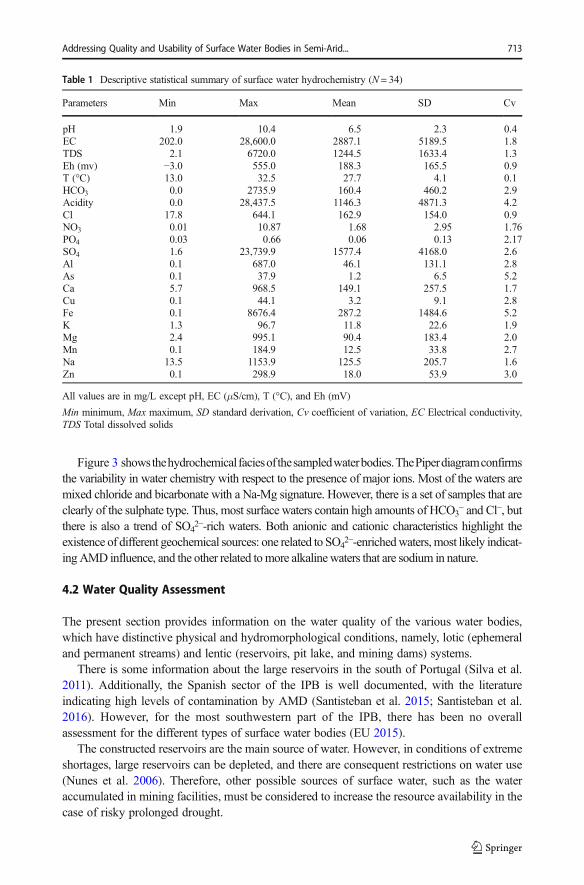
Figure 3 showsthehydrochemicalfaciesofthesampledwaterbodies.ThePiperdiagramconfirmsthe variability in water chemistry with respect to the presence of major ions. Most of the waters aremixed chloride and bicarbonate with a Na-Mg signature. However, there is a set of samples that areclearly of the sulphate type. Thus, most surface waters contain high amounts of HCO3
− and Cl−, butthere is also a trend of SO4
2−-rich waters. Both anionic and cationic characteristics highlight theexistence of different geochemical sources: one related to SO4
2−-enrichedwaters,most likely indicat-ingAMD influence, and the other related tomore alkalinewaters that are sodium in nature.
4.2 Water Quality Assessment
The present section provides information on the water quality of the various water bodies,which have distinctive physical and hydromorphological conditions, namely, lotic (ephemeraland permanent streams) and lentic (reservoirs, pit lake, and mining dams) systems.
There is some information about the large reservoirs in the south of Portugal (Silva et al.2011). Additionally, the Spanish sector of the IPB is well documented, with the literatureindicating high levels of contamination by AMD (Santisteban et al. 2015; Santisteban et al.2016). However, for the most southwestern part of the IPB, there has been no overallassessment for the different types of surface water bodies (EU 2015).
The constructed reservoirs are the main source of water. However, in conditions of extremeshortages, large reservoirs can be depleted, and there are consequent restrictions on water use(Nunes et al. 2006). Therefore, other possible sources of surface water, such as the wateraccumulated in mining facilities, must be considered to increase the resource availability in thecase of risky prolonged drought.
Table 1 Descriptive statistical summary of surface water hydrochemistry (N = 34)
Parameters Min Max Mean SD Cv
pH 1.9 10.4 6.5 2.3 0.4EC 202.0 28,600.0 2887.1 5189.5 1.8TDS 2.1 6720.0 1244.5 1633.4 1.3Eh (mv) −3.0 555.0 188.3 165.5 0.9T (°C) 13.0 32.5 27.7 4.1 0.1HCO3 0.0 2735.9 160.4 460.2 2.9Acidity 0.0 28,437.5 1146.3 4871.3 4.2Cl 17.8 644.1 162.9 154.0 0.9NO3 0.01 10.87 1.68 2.95 1.76PO4 0.03 0.66 0.06 0.13 2.17SO4 1.6 23,739.9 1577.4 4168.0 2.6Al 0.1 687.0 46.1 131.1 2.8As 0.1 37.9 1.2 6.5 5.2Ca 5.7 968.5 149.1 257.5 1.7Cu 0.1 44.1 3.2 9.1 2.8Fe 0.1 8676.4 287.2 1484.6 5.2K 1.3 96.7 11.8 22.6 1.9Mg 2.4 995.1 90.4 183.4 2.0Mn 0.1 184.9 12.5 33.8 2.7Na 13.5 1153.9 125.5 205.7 1.6Zn 0.1 298.9 18.0 53.9 3.0
All values are in mg/L except pH, EC (μS/cm), T (°C), and Eh (mV)
Min minimum, Max maximum, SD standard derivation, Cv coefficient of variation, EC Electrical conductivity,TDS Total dissolved solids
Addressing Quality and Usability of Surface Water Bodies in Semi-Arid... 713

The suitability of water for irrigation and drinking was evaluated according to the Europeanand national standards (Table 2). Regarding irrigation, all samples had Sn and NO3
− valuesbelow the recommended maximum value (RMV). However, the maximum admissible value(MAV) of most elements was exceeded. Both pH and EC presented samples with values thatwere outside the permissible values for the two types of water uses.
Specifically, for drinking purposes, there were samples outside the guideline values for allthe analysed elements. Chloride deserves special consideration because 91% of the sampleswere above the MAV. In fact, Cl− and SO4
2− were key indicators that had a high percentage ofnon-compliant samples. These two parameters indicate anthropogenic impacts, such as thoserelated to mining. The formation of sulphate-rich waters through the complex chain of AMDreactions is a typical problem arising from the evolution of mining waste (Rimstidt andVaughan 2003). It is important to note the existence of seven important polymetallic mines(Fig. 1). Here, AMD originates from waste dumps, old cementing basins and open pits, and isdischarged into the watercourses, promoting river contamination (Valente et al. 2015).
4.2.1 Water Classification According to EC and SAR Values
By considering the non-compliance with legislation for many parameters regarding irrigation use(Table 2), the samples were classified according to the EC and SAR values. Figure 4 presents aclassical tool that is used to assess the water quality for irrigation use (Wilcox 1955). Salinity andsodium risks are among the main factors affecting the suitability of water for irrigation (Mirabbasi
Fig. 3 Piper diagram for surface water samples
714 Gomes P. et al.

et al. 2008). As stated by Ayers and Westcot (1985), excessive sodium ions in water can replacecalcium and magnesium, reduce permeability and cause soil degradation. Therefore, the combinedeffect of sodium risk and salinity risk is represented in the diagram by using EC to compute salinityrisk and SAR to compute alkalinity risk, because SAR is related to the extent to which sodium isadsorbed by the soil. Samples can be classified as of low, medium, high, very high or exceptionallyhigh salinity (x-axis) or sodium adsorption (y-axis) (Singh et al. 2005).
Most of the analysed samples fall into the group of medium to very high risk of salinizationand low risk of sodium (Fig. 4). The majority of the reservoirs and one river water (RV - Rib.Vascões, Fig. 2) are included in the group (C2-S1), which corresponds to a medium risk ofsalinization. Following group C3-S1 were some reservoirs and two mining dams (BE and CC,Fig. 2). The most problematic waters are those with very high (C4-S1) or exceptionally highrisks of salinization (C5), representing the influence of mining waste. Therefore, as expected,this last category included samples from a pit lake and mining dams, with the sample RCM(Fig. 2) positioned in the most extreme category (C5-S4). Furthermore, it should be noted thatthe sample CCR (i.e., the stream water in the vicinity of mining wastes, Fig. 2) was outside thelimits of the diagram due to an extreme degree of contamination, with an EC value of 28,000μS/cm. On the other hand, only two samples from constructed reservoirs presented a low risk
Table 2 Recommended Maximum Value (RMV) and Maximum Admissible Value (MAV) for irrigation anddrinking waters, according to the European and National standards for water quality and percentage of samples ineach range
Irrigation water Drinking water
Parameters RMV MAV <RMV [RMV;MAV]
>MAV
RMV MAV <RMV [RMV;MAV]
>MAV
Al 5 20 73% 9% 18% 0.05 0.2 53% 18% 29%As 0.1 10 88% 9% 3% 0.05a 0.05 88% – 12%Be 0.5 1 79% 0% 21% – – – – –Cd 0.01 0.05 68% 0% 32% 0.005a 0.005 68% – 32%Pb 5 20 65% 9% 26% 0.05a 0.05 53% – 47%Cl 70 70b 39% – 61% 25 25b 9% – 91%Co 0.05 10 68% 32% 0% – – – – –Cu 0.2 5 71% 18% 12% 3 3b 85% – 15%Cr 0.1 20 97% 3% 0% n.a. n.a. n.a. n.a. n.a.Sn 2 2b 100% – 0% n.a. n.a. n.a. n.a. n.a.Fe 5 5b 79% – 21% 0.05 0.2 47% 18% 35%Li 2.5 5.8 53% 9% 38% n.a. n.a. n.a. n.a. n.a.Mn 0.2 10 62% 15% 24% 0.02 0.05 62% 0% 38%Mo 0.005 0.05 91% 0% 9% n.a. n.a. n.a. n.a. n.a.Ni 0.5 2 94% 6% 0% 0.05a 0.05 82% – 18%Zn 2 10 71% 6% 24% 0.005 0.005b 62% – 38%NO3 50 50b 100% – 0% 25 50 82% 6% 12%SO4 575 575b 65% – 35% 25 250 18% 0% 82%NO2 n.a. n.a. 0% 0% 0% 0.1a 0.1 18% – 82%Hardness n.a. n.a. 0% 0% 0% 500a 500 82% – 18%EC 1000 1000b 53% – 47% 400 400b 18% – 82%pH 6.5–8.4 4.5–9.0 26% 65% 9% 6.5–8.5 9.5 47% 47% 6%
All values are in mg/L except pH and EC (μS/cm)
n.a. not applicablea the legislation does not provide RMV, so MAV was usedb the legislation does not provide MAV, so RMV was used
Addressing Quality and Usability of Surface Water Bodies in Semi-Arid... 715

of salinization and sodium. Therefore, they can be directly used for irrigation, with no dangerof the exchangeable development of sodium and salinity.
Globally, this classification indicates that the majority of surface waters present medium, highor very high risks of salinization, thus requiring treatment before use. Despite this result, most ofthe analysed reservoirs are extensively used for irrigation. This usage in cultivated land is of majorconcern in the Mediterranean region, where there is a considerable risk of soil salinization andland desertification (Zalidis et al. 2002; Verheye and de la Rosa 2005; AllEnvi 2016).
4.2.2 Cluster Analysis
Given the spatial distribution of the samples (Fig. 2) and their hydromorphological, physical, andhydrochemical variabilities, cluster analyses were performed to expose the existence of similaritybetween them. One of the most efficient grouping methods is hierarchical cluster analysis, whichenables the ability to find proximity relationships between variables. This method has beenextensively applied for classification purposes in different types of water environments (ShresthaandKazama 2007;Kamble andVijay 2011; Perrin et al. 2018). The efficiency of this cluster analysishas also been demonstrated when applied to extreme types of environments, such as AMD-affectedsystems (Grande et al. 2013b; Cerón et al. 2014; Valente et al. 2016).
Fromtheoutputof thedendrogram(Fig.5), twomajorclassesarerevealed to the levelofclustering:Group1(G1),whichiscomposedofsamplesfromconstructedreservoirsandrivers,andGroup2(G2),which includes samples influenced bymining, namely dams, pit lakes, and ephemeral streams.
Fig. 4 Irrigation water classification diagram (after Richards 1954)
716 Gomes P. et al.

Most of the samples are classified as G1, including the constructed reservoirs, one river water(RV - Rib. Vascões) and a mining dam (B3). In turn, this major group comprised two subgroups(G1SG1 and G1SG2), which represent differences in terms of mineralization. In fact, G1SG2includes reservoirs with higher EC and Cl−. The inclusion of themining damB3 in G1SG2 togetherwith the constructed reservoirs used for irrigation and drinking is in accordance with the physico-chemical treatment that this water undergoes to reduce pollution; therefore, this treatment minimizesthe environmental impact of the mining effluents generated in the Aljustrel mine.
Group G2 consisted of three major subgroups (G2SG1, G2SG2, and G2SG3) that includedmining dams, pit lakes and stream waters. The G2SG1 subgroup, which was composed of onlystream water from Canal Caveira Ribeira, emerged immediately due to its higher distancerelative to the other leaves of the dendrogram. This independent classification reflects thestrong AMD contamination of this sample because the stream receives the leachates from thewaste dumps of a polymetallic sulphide mine (Canal Caveira, Figs. 1, and 2).
Subgroup G2SG3 is composed mainly of a set of samples from the same site, i.e., the SãoDomingos mine (B3 (S.D.); B4 (S.D.); B5 (S.D.); and B12 (S.D.)). This discriminationrevealed similar hydrochemistry, highlighting the same paragenetic signature that was associ-ated with the mining wastes accumulated in this mining complex.
Finally, subgroup G2SG2 included the remaining waters that experience mining influence.At a lower level (distance <5), it was possible to discriminate between two alkaline miningdams (BAC and B1 (BE)). Although these dams experience environmental control, the watershad high levels of sulphate that attested their mining signature. With less similarity, there is theleaf of Lagoa Vermelha, which corresponded to a pit lake with strongly acidic water.
Figure 6 shows the centroid vector of each subgroup identified by the hierarchical classifier.In accordance with the dendrogram, these vectors illustrate the distinction between the types ofwater samples, although the different parameters reveal different discriminating vocations. Forexample, group G2 shows the influence of mining contamination, including most acidic andsulphate-rich waters. Thus, SO4
2−, EC, Fe (total) and acidity are the major distinguishingfactors, with increasing concentrations along the subgroups.
Possible differences between lotic and lentic waters as well as general physical andhydromorphological features are not reflected in these cluster analyses. Thus, a permanentstream (Ribeira de Vascões), which represents the general features of the regional background,appears to be grouped with several constructed reservoirs. On the other hand, the ephemeralstreams are mainly discriminated by the influence of mining. Therefore, the existence or not ofmining contamination overlaps the physical and hydromorphological differences.
Considering these five clusters, an overall assessment of the water quality for the regionis now proposed, attending to the legal framework for irrigation and drinking water(Table 2). Thus, the nearest centroid classifier was applied to the vector that representedeach subgroup centroid and to the vector that represented the recommended maximumvalue (RMV) for irrigation and drinking water classes. Figure 7 shows the result of thisclassification algorithm. At this point, it is possible to observe the segregation of surfacewaters based on distinctive levels of contamination. The y-axis represents the distancefrom the subgroup centroid to the quality parameter that defined the irrigation and drinkingclasses. As the value on the y-axis increases, the distance to the class increases; this wasassociated with degraded water quality. Therefore, Fig. 7 shows that the level of contam-ination increases on the x-axis from G1SG1 to G2SG1. Additionally, the line correspond-ing to the irrigation class is below the line corresponding to the drinking class; thus, thesewaters have characteristics closer to irrigation usage.
Addressing Quality and Usability of Surface Water Bodies in Semi-Arid... 717

4.2.3 Radial Diagram Analysis
Figures 8 and 9 present the behaviour of the two major groups of water bodies (i.e., G1 andG2, respectively) for a set of selected parameters: EC, SO4
2−, HCO3−, Al, Ca, Cu, Fe (total),
Mg, Mn, Na, and Zn.
0 5 10 15 20 25 Corte Sines 1 5
Boavista 12Tapada Grande 27
Vale travessos 4
Corte Sines 2 6Monte Migueis 11
Odeleite 1Chança 33Monte Clérigo 13
Monte Novo 24
Campilhas 21
B3 16Ataboeira 34
Herdade dos Lagos II 26S.J. Caldeireiros 3
Roxo 9Monte Ruas 10
Tapada Pequena 28Penedrão 25
Rib. Vascões 2
Tapada 20B3 (S.D.) 29
B12 (S.D.) 32
B4 (S.D.) 30Canal Caveira B1 22
B5 (S.D.) 31BAC 14
B1 (BE) 15
Lagoa Azul 17Ribeira Corona 19
Poço Retorno 7RCM 8
Lagoa Vermelha 18Canal Caveira Ribeira 23
Ward’s Method, Euclidean
G1SG1
G1SG2
G2SG2
G2SG3
G2SG1
G1
G2
Fig. 5 Dendrogram of water samples with p value between G1 and G2 of 10%
718 Gomes P. et al.

In Group I (Fig. 8), the samples of Herdade dos Lagos II, B3, Ataboeira, and Roxoexceeded 1000 μS/cm for EC. For all reservoirs, SO4
2− was below the radius of 100 mg/L.In fact, B3 had the highest concentration of SO4
2− and of trace elements in general, possibly as
0,01 0,1 1 10 100 1000 10000 100000
G1SG1
G1SG2
G2SG3
G2SG2
G2SG1
pH
EC
Alk
Aci
Cl
SO4
Al
As
Ca
Cu
Fe
Mg
Mn
Na
Zn
Parameters ValueP
ara
meters
Fig. 6 Centroids of each cluster defined in the dendrogram (Fig. 5)
Addressing Quality and Usability of Surface Water Bodies in Semi-Arid... 719

a result of some AMD influence due to the proximity to the Aljustrel mine (Fig. 2). Regardingthe anions, Ataboeira presented higher concentrations of Cl−, NO2
−, and NO3−, suggesting a
possible source of organic contamination. In general, all samples had higher amounts of Ca,Na and Mg, and low concentrations of Al, Cu, Fe (total), Mn, and Zn. Reservoirs such asMonte Novo, Corte de Sines II, Chança, and Ataboeira had higher values of Fe (total). On theother hand, the Roxo reservoir presented higher concentrations of Cu, which can also suggest aslight AMD contribution. An important insight came from the Chança Reservoir, which isused for the production of drinking water. Although it is downstream of the São Domingosmine (Figs. 1 and 2) and receives drainage from this mining complex, this reservoir does notappear to be strongly contaminated by the mining effluents. However, the higher SO4
2− and Fe(total) contents relative to other reservoirs shown in Fig. 8 may reflect some influence from themining environment. As a conservative element, SO4
2− persists in solution, supporting thehigher concentrations that were observed.
Group II, shown in Fig. 9, shows a rather different behavioural pattern. The samples had thehighest EC and the lowest concentration of HCO3
−. The samples from BAC, B1, and PoçoRetorno are exceptions, probably because they are located within active mining complexes(i.e., Aljustrel and Neves Corvo; Figs. 1 and 2); thus, the sites are subjected to environmentalcontrol measures that include the use of alkaline products for neutralization. Ribeira Coronarepresents stream water that was clearly affected by AMD, as was indicated by the sulphateand metallic patterns. In general, the diagrams in Fig. 9 show a metallic signature, with theexception of BAC, which had only Na, Mg, and Ca. This exception is explained by the watertreatment procedures carried out for this dam.
The last sample, which is presented in Fig. 9, had the highest concentrations of the elementswith toxicological concern, such as metals, as well as SO4
2−, and EC. This sample, Canal CaveiraRibeira, is an AMD-affected stream because it directly receives drainage from the old exploitationof polymetallic sulphides (Canal Caveira; Figs. 1 and 2). It should be noted that this minepreviously underwent environmental rehabilitation. However, the results show that there is stillcontamination of the surface water promoted by the leachates of the dumped waste.
0
10
20
30
40
50
60
70
80
90
100
G1SG1 G1SG2 G2SG3 G2SG2 G2SG1
sessalcot
ecnatsiD
Groups discriminated in the dendrogram
Irriga�on Class
Drinking Class
Fig. 7 Distance from the cluster centroids to the irrigation and drinking classes
720 Gomes P. et al.

In general, the water quality and usability in the IPB are influenced by two main types ofsources/activities. The impact of AMD is clear on mining water bodies, such as pit lakes anddams. Additionally, ephemeral streams show evidence of mining contamination (samples inFig. 9). In the present conditions, the usability of these waterbodies is completely compro-mised, including the uses related to supporting ecological services.
Fig. 8 Radial diagrams of Group 1 samples for a set of selected parameters
Addressing Quality and Usability of Surface Water Bodies in Semi-Arid... 721

Pasture and wastewater discharges may affect the other constructed reservoirs (Fig. 8). Thismay explain the non-compliance for irrigation that was observed for chloride in more than90% of the samples. Only two samples presented a low risk of salinization when used forirrigation (Fig. 4), which represents a critical limitation for actual use.
Fig. 9 Radial diagrams of Group 2 samples for a set of selected parameters
722 Gomes P. et al.

5 Conclusions
Water resources are critical for sustainable development, including agricultural and populationgrowth as well as ecosystem conservation. With the decreasing precipitation levels observed insouthwestern Europe, water shortages are increasingly common events. In some extremecases, the population may have to use recycled water for public uses. Therefore,hydrochemical characterization and environmental assessments are crucial for a global per-spective of the water quality in semi-arid regions with historic mining activity. Thehydrochemical characterization of surface water bodies in the IPB revealed a dominantHCO3
−-Cl− or SO42− pattern, depending on the AMD contributions. As a result, cluster
analysis better reflects the discrimination of the waters exposed to mining contamination.Generally, waste dumps in abandoned mining areas still constitute a risk of contamination,even in cases that were subjected to environmental rehabilitation.
The obtained results suggest the need for remediation measures to protect the aquaticenvironment. The mitigation of organic pollution depends on agro-environmental measuresand investments in controlling the discharge of wastewater. However, a greater challenge isposed by abandoned mining sites. The imperative investment in the data collection andtreatment related to AMD is required. The passive systems that have already been implement-ed have proven to be inefficient. Greater effort may be required in terms of maintenance oreven in the choice of treatment solutions. Furthermore, though completely different, therenewal of mining activity in the context of a circular economy may be possible. The currentstrategy to recover by-products in waste-dumps, and even in mine waters, may help controlAMD and promote sustainable water management.
These types of research activities in the field of monitoring may contribute to the increasedavailability of water resources, which may benefit situations of water scarcity in semi-aridregions with mining traditions.
Acknowledgments Patrícia Gomes acknowledge FCT (Science and Technology Foundation, Portugal) by theresearch fellowship under the POCH (Programa Operacional Capital Humano) supported by the European SocialFund and National Funds of MCTES (Ministério da Ciência, Tecnologia e Ensino Superior) with referenceSFRH/BD/108887/2015. This work was co-funded by the European Union through the European RegionalDevelopment Fund, based on COMPETE 2020 (Programa Operacional da Competitividade eInternacionalização) - project ICT (UID/GEO/04683/2013) with reference POCI-01-0145-FEDER-007690 andproject Nano-MINENV number 029259.
The authors are also deeply grateful to Associate Editor and to the anonymous reviewers for their valuablecomments and suggestions.
Compliance with Ethical Standards
Conflict of Interest None
References
Abreu M, Batista MJ, Magalhães MC, Matos JX (2010) Acid mine drainage in the Portuguese Iberian PyriteBelt. In: Robinson BC (ed) Mine drainage and related problems. Nova Science Pub, New York, pp 71–118.isbn:978-1-60741-285-4
Addressing Quality and Usability of Surface Water Bodies in Semi-Arid... 723
AllEnvi (ed) (2016) The Mediterranean region under climate change. IRD Editions, Paris, p 736. isbn:9782709922197
ASTM 5245 (1992) Standard practice for cleaning laboratory glassware, plasticware and equipment used inmicrobiological analysis. ASTM committee on standards. American Society for Testing and Materials, 5
Ayers RS, Westcot DW (1985) Water quality for agriculture. FAO, RomeBarriga FJAS, Carvalho D, Ribeiro A (1997) Introdution to the Iberian Pyrite Belt. Society of Economic
Geologists (U.S.). Field Conference, Neves Corvo, Guidebook 27:1–20Cerón J, Grande J, de la Torre M, Borrego J, Santisteban M, Valente T (2014) Hydrochemical characterization of
an acid mine drainage-affected reservoir: the Sancho reservoir, Huelva, Southwest Spain. Hydrol Sci J 59(6):1213–1224
Christopher DM, Prabhakar R, Hinrich S (2009) An introduction to information retrieval. Cambridge UniversityPress, Cambridge, pp 163–167
EU (2015) Report on the implementation of the Water Framework Directive River Basin Management Plans,Member State: Portugal, Brussels, p 103
Fernandes P, Jorge R, Pereira Z, Oliveira T (2008) Geochemistry of the Baixo Alentejo Flysch Group, SouthPortuguese Zone: Implications for provenance and palaeoweathering. Goldschmidt Conference Abstracts2008, A264
Ferreira da Silva E, Durães N, Reis P, Patinha C, Matos J, Costa MR (2015) An integrative assessment ofenvironmental degradation of Caveira abandoned mine area (southern Portugal). J Geochem Explor 159:33–47
Freeze RA, Cherry JA (1979) Groundwater. Prentice-Hall, Englewood Cliffs, p 604Geller W, Schultze M, Kleinmann R, Wolkersdorfer C (2013) Acidic pit lakes – the legacy of coal and metal
surface mines. Springer. https://doi.org/10.1007/978-3-642-29384-9Gomes P, Valente T, Sequeira Braga MA, Grande JA, de la Torre ML (2016) Enrichment of trace elements in the
clay size fraction of mining soils. Environ Sci Pollut Res 23(7):6039–6045Grande JA, Santisteban M, de la Torre ML, Valente T, Pérez-Ostalé E (2013a) Characterisation of AMD
pollution in the reservoirs of the Iberian Pyrite Belt. Mine Water Environ 32:321–330. https://doi.org/10.1007/s10230-013-0236-6
Grande JA, Carro B, Borrego J, de la Torre ML, Valente T, Santisteban M (2013b) Hydrogeochemical variablesregionalization – applying cluster analysis for a seasonal evolution model from an estuarine system affectedby AMD. Mar Pollut Bull 69:150–156
Grande JA, de la Torre ML, Valente T, Borrego J, Santisteban M, Cerón JC, Sánchez-Rodas D (2015)Stratification of metal and sulphate loads in acid mine drainage receiving water dams - variables regional-ization by cluster analysis. Water Environ Res 87:626–634. https://doi.org/10.2175/106143015x14212658614793
IPMA - Instituto Português do Mar e da Atmosfera (2018) Boletim climatológico, Janeiro 2018, p 13, ISSN2183–1076
Kamble S, Vijay R (2011) Assessment of water quality using cluster analysis in coastal region of Mumbai, India.Environ Monit Assess 178:321–332
Leistel JM, Bonijoly D, Braux C, Freyssinet P, Kosakevitch A, Leca X, Lescuyer JL, Marcoux E, MileÂsi JP,Piantone P, Sobol F, Tegyey M, ThieÂblemont D, Viallefond L (1994) The massive sulphide deposits of theSouth Iberian Pyrite Province: geological setting and exploration criteria. BRGM, Doc 234, p 236
Matos JX, Martins LP, Oliveira JT, Pereira Z, Batista MJ, Quental L (2008) Rota da pirite no sector português daFaixa Piritosa Ibérica, desafios para um desenvolvimento sustentado do turismo geológico e mineiro.Projecto RUMYS, programa CYTED, Livro Rutas Minerales en Iberoamérica, Ed. Paul Carrion, Esc.Sup. Politécnica del Litoral, Guayaquil, Equador, pp 136–155. http://hdl.handle.net/10400.9/370
Mirabbasi R, Mazloumzadeh M, Rahnama B (2008) Evaluation of irrigation water quality using fuzzy logic. ResJ Environ Sci 2:340–352
Nunes N, Monteiro JP, Cunha C, Vieira J, Lucas H (2006) The water crisis in southern Portugal: how did we getthere and how should we solve it. WIT Trans Ecol Environ 99:435–444
Nunes JP, Jacinto R, Keizer JJ (2017) Combined impacts of climate and socio-economic scenarios on irrigationwater availability for a dry Mediterranean reservoir. Sci Total Environ 584–585:219–233
Perrin J, Salles C, Bancon-Montigny C, Raïs N, Chahinian N, Dowse L, Rodier C, Tournoud M (2018)Comparison of index systems for rating water quality in intermittent rivers. Environ Monit Assess 190:70.https://doi.org/10.1007/s10661-017-6396-2
Piper AM (1944) A graphic procedure in the geochemical interpretation of water analyses. Trans Am GeophysUnion 25:914–923
Relvas JMRS, Barriga FJAS, Pinto A, Ferreira A, Pacheco N, Noiva P, Barriga G, Baptista R, Carvalho D,Oliveira V, Munhá J, Hutchinson R (2002) The Neves-Corvo deposit, IPB, Portugal: 25 years after thediscovery. Society of Economic Geologists, Special Publication 9:155–176
Richards LA (1954) Diagnosis improvement saline alkali soils. US Department of Agriculture Handbook. No. 60
724 Gomes P. et al.

Rimstidt JD, Vaughan DJ (2003) Pyrite oxidation: a state-of-the-art assessment of the reaction mechanism.Geochim Cosmochim Acta 65(5):873–880
Rodrigues R (Coord.) (2011) A herança das minas abandonadas - O enquadramento e atuação em Portugal. EDM– DGEG, p 180 http://www.edm.pt/html/livro.html#/14/
Sáez R, Pascual E, Toscano M, Almodovar G (1999) The Iberian type of volcanosedimentary massive sulphidedeposits. Mineral Deposits 34:549–570
Santisteban M, Grande JA, de la Torre ML, Valente T, Cerón T (2015) Acid mine drainage in semi-arid regions:The extent of the problem in the waters of reservoirs in the Iberian Pyrite Belt (SW Spain). Hydrol Res 46(1):156–167
Santisteban M, Valente T, Grande JA, de la Torre ML, Almeida S, Pérez-Ostalé E, García-Pérez M (2016) Studyof the transit and attenuation of pollutants in a water reservoir receiving acid mine drainage in the IberianPyrite Belt (SW Spain). Water Sci Technol 16(1):128–134
Shrestha S, Kazama F (2007) Assessment of surface water quality using multivariate statistical techniques: a casestudy of the Fuji river basin, Japan. Environ Model Softw 22:464–475
Silva H, Morais M, Rosado J, Serafim A (2011) South Portugal Reservoirs – Status and major concerns. 12 nd IntSpec Conf Watershed River Basin Manag 8
Singh AK, Mondal GC, Singh PK, Singh S, Singh TB, Tewary BK (2005) Hydrochemistry of reservoirs ofDamodar River basin, India: weathering processes and water quality assessment. Environ Geol 48(8):1014–1028
Suthar S, Sharma J, Chabukdhara M, Nema AK (2010) Water quality assessment of river Hindon at Ghaziabad,India: impact of industrial and urban wastewater. Environ Monit Assess 165:103–112. https://doi.org/10.1007/s10661-009-0930-9
Tiri A, Lahbari N, Boudoukha A (2014) Hydrochemical characterization of surface water in the Timgadwatershed, East Algeria. Desalin Water Treat 57:562–571
US Salinity Laboratory Staff (1954) Diagnosis and improvement of saline and alkali soils. US Department Agric.Handbook N° 60, p 160
Valente TM, Leal Gomes C (2009) Occurrence, properties and pollution potential of environmental minerals inacid mine drainage. Sci Total Environ 407:1135–1152. https://doi.org/10.1016/j.scitotenv.2008.09.050
Valente T, Grande JA, de la Torre ML, Gomes P, Santisteban M, Borrego J, Sequeira Braga MA (2015)Mineralogy and geochemistry of a clogged mining reservoir affected by historical acid mine drainage inan abandoned mining area. J Geochem Explor 157:66–76. https://doi.org/10.1016/j.gexplo.2015.05.016
Valente T, Grande JA, Cerón JC, de la Torre ML, Santisteban M, Borrego J, Fernández P, Sanchez-Rodas D(2016) Spatial distribution of major and trace elements in a mining dam: sources and relationships amongelements of environmental concern. Environ Earth Sci 75:342. https://doi.org/10.1007/s12665-015-4863-z
Verheye W, de la Rosa D (2005) Mediterranean soils, in land use and land cover, from encyclopedia of lifesupport systems (EOLSS), developed under the auspices of the UNESCO. Eolss Publishers, Oxford
Ward JH (1963) Hierarchical grouping to optimize an objective function. J Am Stat Assoc 58:236–244Wilcox LV (1955) Classification and use of irrigation waters. USDA. Circ 969, Washington, DCZalidis G, Stamatiadis S, Takavakoglou V, Eskridge K, Misopolinos N (2002) Impacts of agricultural pratices on
soil and water quality in Mediterranean region and proposed assessment methodology. Agric EcosystEnviron 88:137–146
Zhang B, Song X, Zhang Y, Han D, Tang C, Yu Y, Ma Y (2012) Hydrochemical characteristics and water qualityassessment of surface water and groundwater in Songnen plain, Northeast China. Water Res 46:2737–2748.https://doi.org/10.1016/j.watres.2012.02.033
Addressing Quality and Usability of Surface Water Bodies in Semi-Arid... 725