admin manual october2012 - tucson...administrative manual is a supplemental document to the city of...
TRANSCRIPT

Administrative Manual
Supplement to the Unified Development Code
Adopted – October 9, 2012 Effective – January 2, 2013


TABLE OF CONTENTS SECTION 1: GENERAL PROVISIONS……………………………………………………………...…..1 1-01.1.0 Establishment………………………………………………………………………..…..... 2 1-01.2.0 Purpose…………………………………………………………………………………… 2 1-01.3.0 Maintenance and Publication……………………………………………………...……... 2 1-01.4.0 Enforcement……………………………………………………………………………..... 2 1-01.5.0 Procedure to Amend the Administration Manual……………………………………...….. 2 SECTION 2: APPLICATION SUBMITTAL REQUIREMENTS…………………………………………….4 2-01.0.0 Permitted Modifications to the Application Submittal Requirements……………………… 5 2-02.0.0 Plan Amendment Applications……………………………………………………………. 6 2-03.0.0 Rezoning (Change of Zoning) Applications……………………………………………….. 8 2-04.0.0 Planned Area Development Rezoning Application……………………………………….. 18 2-05.0.0 Planned Community Development Rezoning Application…………………………………. 22 2-06.0.0 Development Package Applications……………………………………………………… 27 2-07.0.0 Final Plat, Block Plat, Minor Subdivision, and Condominium Plat Applications…………… 44 2-08.0.0 Land Split Applications…………………………………………………………………… 54 2-09.0.0 Assurances………………………………………………………………………………... 56 2-10.0.0 Landscaping Plan Requirements………………………………………………………….. 62 2-11.0.0 Native Plant Preservation Plan Requirements…………………………………………….. 66 2-12.0.0 Protected Development Right Applications……………………………………………….. 74 2-13.0.0 Folding a 24” x 36” Sheet to 8.5” x 11” Format………………………………………… 76 SECTION 3: REVIEW COMMITTEE AND COMPLIANCE REVIEW TIMEFRAMES POLICY….……….…77 3-01.0.0 City Development Review Committee……………………………………………..……… 78 3-02.0.0 Compliance Review Timeframes Policy…………………………………………………… 83 3-03.0.0 Flexible Application Process……………………………………………………………… 91 SECTION 4: DEVELOPMENT REVIEW FEE SCHEDULE…………………………………………..……..100 SECTION 5: DEFINITIONS……………………………………………………………………..……….130


1
SECTION 1: GENERAL PROVISIONS

ADMINISTRATIVE MANUAL SECTION 1: GENERAL PROVISIONS Section 1-01.0.0 General Provisions
2
1-01.0.0 GENERAL PROVISIONS 1-01.1.0 ESTABLISHMENT 1-01.2.0 PURPOSE 1-01.3.0 MAINTENANCE AND PUBLICATION 1-01.4.0 ENFORCEMENT 1-01.5.0 PROCEDURE TO AMEND THE ADMINISTRATIVE MANUAL 1-01.1.0 ESTABLISHMENT
The City of Tucson Administrative Manual (“Administrative Manual”) is established as Administrative Directive 1.02-9, under the City of Tucson Administrative Directives. The Administrative Manual is a supplemental document to the City of Tucson Unified Development Code.
1-01.2.0 PURPOSE
The purpose of the Administrative Manual is to establish criteria that ensure that land development is properly planned and executed with due consideration for public services and facilities, topographic constraints, and the general public's health, safety, and welfare and that review of land development proposals are completed in a timely manner. Specifically, the Administrative Manual establishes the following:
1.1 Application submittal requirements; 1.2 Permitted modifications to the application submittal requirements; 1.3 City Development Review Committee review procedures; and, 1.4 Development review fees.
1-01.3.0 MAINTENANCE AND PUBLICATION
The Planning and Development Services Department (PDSD) is responsible for maintaining and publishing the Administrative Manual. The Administrative Manual is available as a public record in the City Clerk’s Office, the PDSD, and the agency responsible for their initiation and/or review. The Administrative Manual is also available on the PDSD website.
1-01.4.0 ENFORCEMENT
The department and/or agency responsible for the adopted Administrative Manual section are responsible for its implementation.
1-01.5.0 PROCEDURE TO AMEND THE ADMINISTRATIVE MANUAL
5.1 Purpose The purpose of this section is to establish the procedure for amending the Administrative Manual.
5.2 Applicability
The amendment procedure provided below applies to amendments to Sections 1, Establishment of the Administrative Manual; 2, Submittal Requirements; 3, City Development Review Committee Procedure; and 5, Definitions. The amendment procedure for Development Review Fees is provided in Section 4.

ADMINISTRATIVE MANUAL SECTION 1: GENERAL PROVISIONS Section 1-01.0.0 General Provisions
3
5.3 Initiation Only the Mayor and Council, City Manager, or the Director of any City department or non-City agency involved in development review may initiate amendments to the Administrative Manual.
5.4 Review
A. Proposed amendments are submitted to the Planning and Development Services Department (PDSD) for review.
B. The PDSD Director will determine whether review of the proposed amendment requires review and comment by the public, City Development Review Committee (CDRC), and/or any other City department or non-City agency involved in the review of development applications.
C. The PDSD Director will ensure that community members affected by any proposed or revised Administrative Manual section, including annual subscribers to the Administrative Manual, have the opportunity to review and comment on such proposals. These individuals are notified by the PDSD that a draft Administrative Manual section is available for review. Anyone interested in reviewing the draft Administrative Manual section proposal may request a copy from the PDSD. The public review may occur concurrently with preliminary CDRC review.
D. The proposed amendment may be revised based on any comments received.
5.5 Decision A. Following review of the proposal, the PDSD Director transmits the Administrative
Manual section to the director of the initiating department for consideration, approval, and signature.
B. Upon approval and signature by the director of the initiating department, the proposal is returned to the PDSD Director for consideration. The PDSD Director may determine to approve, deny, or request further revisions to the proposed amendment.
C. If approved, the PDSD Director’s decision is final, and the Administrative Manual section becomes effective upon the signature of the PDSD Director, unless the PDSD Director refers the matter to the Mayor and Council for consideration and action.
D. In situations where the Administrative Manual section is established or amended through adoption of an ordinance by the Mayor and Council, the effective date of the ordinance will apply.
5.6 Notice of Decision Notice of the PDSD Director’s or the Mayor and Council’s decision, whichever is applicable, is sent to the affected governmental and non-governmental agencies and individuals who have requested to be notified of amendments to the Administrative Manual.

4
SECTION 2: APPLICATION SUBMITTAL REQUIREMENTS

ADMINISTRATIVE MANUAL SECTION 2: APPLICATION SUBMITTAL REQUIREMENTS
5
2-01.0.0 PERMITTED MODIFICATIONS TO THE APPLICATION SUBMITTAL REQUIREMENTS
2-01.1.0 GENERAL 2-01.2.0 REQUEST REQUIRED 2-01.3.0 REVIEW AND APPROVAL 2-01.1.0 GENERAL
Upon a request from an applicant, the Planning and Development Services Department (PDSD) Director may allow modifications and exceptions to the application submittal requirements for all application and plan types, except the Protected Development Right Plan requirements.
2-01.2.0 REQUEST REQUIRED
Requests from applicants for modifications and exceptions to the submittal requirements must be made prior to submittal of the application. The request must identify the submittal requirement(s) being requested for modification or exception and provide a rationale for the change;
2-01.3.0 REVIEW AND APPROVAL
3.1 The PDSD Director may decide to approve or deny the request; 3.2 The PDSD Director shall consider the purpose statements of the applicable plan policies,
zone, overlay, subdivision, site plan, and other development standards when rendering a decision. Approval of the request does not represent the department’s endorsement or approval of the project;
3.3 For projects requiring approval through a legislative procedure, the Zoning Examiner,
Planning Commission, or the Mayor and Council, whichever is applicable, may request additional information concerning the omitted or modified sections during their review and consideration for approval; and,
3.4 The rationale for the approved exceptions shall be included with the submittal.

ADMINISTRATIVE MANUAL SECTION 2: APPLICATION SUBMITTAL REQUIREMENTS
6
2-02.0.0 PLAN AMENDMENT APPLICATIONS
2-02.1.0 APPLICABILITY 2-02.2.0 APPLICATION SUBMITTAL REQUIREMENTS 2-02.3.0 REAPPLICATION 2-02.1.0 APPLICABILITY
This section provides the application submittal requirements for the Land Use Plan Adoption and Amendment Procedure provided in Section 3.6 of the Unified Development Code (UDC).
2-02.2.0 APPLICATION SUBMITTAL REQUIREMENTS
Plan amendment application forms are available from the Planning and Development Services Department. The following documents and information are required upon application. The types of documents and the specific number of copies required of each of the documents are provided in the plan amendment application.
2.1 Application Form
A completed application signed by the property owner or authorized designee is required.
2.2 Neighborhood Meeting Information
Written proof of the offer to meet with the surrounding property owners and other applicable parties in accordance with Section 3.2.2 of the UDC must be submitted with the application. Required documentation includes copies of the meeting notification letter, the mailing list provided to the applicant by the City, the meeting attendance sheet, and the minutes of the meeting. The minutes should include any concerns raised at the meeting and the applicant’s response to them, if any.
2.3 Plan Amendment Request Information.
A. A description of the section of the plan for which the amendment is requested. B. A statement by the applicant explaining why this amendment is necessary and
how it is consistent with the overall goal(s) of the plan. C. Proposed new language and/or maps which incorporate this change.
2.4 Concept Plan Recommended
The applicant is encouraged to submit a concept plan of the proposed development, particularly for sites of two and one-half (2½) acres or greater. The plan will assist staff and the Planning Commission in the determination of whether the proposed plan amendment would be compatible with the surrounding areas. The concept plan is for informational purposes only to assist in the review and consideration of approval of the proposed amendment. The concept plan is not formally adopted through approval of the plan amendment.
2.5 Fees
Fees in accordance with Section 4-01.0.0, Development Review Fee Schedule, is required at the time of application submittal.

ADMINISTRATIVE MANUAL SECTION 2: APPLICATION SUBMITTAL REQUIREMENTS
2-02.0.0 Plan Amendment Applications
7
2-02.3.0 REAPPLICATION In accordance with Section 3.6.11, Reapplication, of the UDC, new plan amendment applications will not be accepted for any property which had a previous application acted upon by the Mayor and Council within one (1) year of the date of that action, except as follows.
3.1 When the application does not involve a request for a zoning district or land use which
was denied; 3.2 When there has been substantial change in the use of the property adjacent to the plan
amendment site since the previous case was heard; or, 3.3 When there has been an ownership change on the plan amendment site and a
substantially modified development concept is presented.

ADMINISTRATIVE MANUAL SECTION 2: APPLICATION SUBMITTAL REQUIREMENTS
2-03.0.0 Rezoning (Change of Zoning) Applications
8
2-03.0.0 REZONING (CHANGE OF ZONING) APPLICATIONS 2-03.1.0 APPLICABILITY 2-03.2.0 APPLICATION SUBMITTAL REQUIREMENTS 2-03.3.0 PRELIMINARY DEVELOPMENT PACKAGE (PDP) FORMAT REQUIREMENTS 2-03.4.0 PRELIMINARY DEVELOPMENT PACKAGE (PDP) CONTENT REQUIREMENTS 2-03.5.0 ENVIRONMENTAL RESOURCE REPORT 2-03.1.0 APPLICABILITY
This section provides the application submittal requirements for the Rezoning (Change of Zoning) Procedure provided in Section 3.5 of the Unified Development Code (UDC).
2-03.2.0 APPLICATION SUBMITTAL REQUIREMENTS Rezoning application forms are available from the Planning and Development Services Department (PDSD). Submit applications and accompanying materials to PDSD. The types of documents and the specific number of copies required of each of the documents are provided in the rezoning application.
The following documents and information must be submitted upon application:
2.1 Application Form
A completed application signed by the property owner or authorized designee is required;
2.2 Neighborhood Meeting Information
Written proof of the offer to meet with the surrounding property owners and other applicable parties in accordance with Section 3.2.2 of the UDC must be submitted with the application. Required documentation includes copies of the meeting notification letter, the mailing list provided to the applicant by the City, the meeting attendance sheet, and the minutes of the meeting. The minutes should include any concerns raised at the meeting and the applicant’s response to them, if any;.
2.3 Development Package or Preliminary Development Package, whichever is applicable
For direct ordinance adoption requests, a Development Package in accordance with Section 2-06.0.0, Development Package, is required. For requests other than direct ordinance adoption, a Preliminary Development Package (PDP) is required in accordance with Sections 2-03.3.0, Format, 2-03.4.0, Content, and, when applicable, 2-03.5.0, Environmental Resource Report.
2.4 Fees
Fees in accordance with Section 4-01.0.0, Development Review Fee Schedule are required. 2-03.3.0 PRELIMINARY DEVELOPMENT PACKAGE (PDP) FORMAT REQUIREMENTS
The PDP shall include:
3.1 A written report in 8.5” x 11” format, which may include maps and photographs; 3.2 Maps must include a legend and north arrow; 3.3 Aerial photographs must be no more than two (2) years old, indicate the flight date, a
north arrow, and the project site boundaries; and,

ADMINISTRATIVE MANUAL SECTION 2: APPLICATION SUBMITTAL REQUIREMENTS
2-03.0.0 Rezoning (Change of Zoning) Applications
9
3.4 Illustration(s) showing the applicable components of the Site Analysis and Plan Proposal:
A. On a 24” x 36” sheet folded to the standard 8.5” x 11” format; B. Fully dimensioned; and, C. Drawn to an appropriate scale (one inch = 40 feet is recommended).
2-03.4.0 PRELIMINARY DEVELOPMENT PACKAGE (PDP) CONTENT REQUIREMENTS
The PDP shall include the following components: 1) Introduction and Policy, Section 2-03.4.1; 2) Site Analysis, Section 2-03.4.2; and, 3) Plan Proposal, Section 2-03.4.3; and, when applicable, 4) Environmental Resource Report, Section 2-03.5.0.
4.1 Introduction and Policy
A. Indicate the applicable subregional, area, or neighborhood plans; B. Provide a summary statement describing how the proposed development complies
or conflicts with adopted plan policies; and, C. Delineate any area of the site proposed for development which would conflict
with an adopted City ordinance or policy.
4.2 Site Analysis A. General
1. A table of contents; 2. A map showing the location of the project site within the boundaries of the
plan area; 3. A small project location map at a scale of one inch = 1,000 feet showing
the rezoning site at the center and indicating what generalized land uses surround it within a one-half (½) mile radius. Major streets should be indentified;
4. The property boundary dimensions;
5. Existing zoning on-site and adjacent to the site. If more than one zone is
requested, identify the location of the proposed zoning boundaries with dimensions and acreage of each zone requested on the Plan Proposal;
6. Locations, size (square footage), and height of all existing buildings within one hundred (100) feet of the project site, dimensioned to show distance to project site boundaries, including approximate densities of residential uses and types of commercial or industrial uses;
7. Locations, size (square footage), and height of all buildings existing or proposed on the project site. Note the approximate setbacks from property boundaries and whether existing buildings will remain as part of the project or if they will be removed; and,
8. Locations of any existing billboards on the project site. Note whether the intent is to leave in place, relocate, or remove;
B. Circulation and Trips

ADMINISTRATIVE MANUAL SECTION 2: APPLICATION SUBMITTAL REQUIREMENTS
2-03.0.0 Rezoning (Change of Zoning) Applications
10
1. Map the following information:
a. Major and/or local streets abutting the project; names and widths of these streets; proposed rights-of-way for the major streets per the Major Streets and Routes (MS&R) Plan; scenic or gateway routes abutting the project site; distance to and identification of nearest major intersection;
b. Existing and proposed curb cuts and access drives; their widths and locations relative to the street intersection or to the project property line; any driveways to be closed;
c. Locations of deceleration or turn lanes if traffic volumes, access,
or other design features require this solution after consultation with the City Traffic Engineer; and,
d. Locations of existing/proposed curbs, driveways, sidewalks, and bike paths both on-site and adjacent off-site; locations of structures, such as poles or transformers, that will require relocation because of new right-of-way improvements.
2. Provide the following information in the form of notes on the map or as part of a separate report.
a. Locations of existing or proposed traffic signals within one (1)
mile of the project boundaries; b. Locations of nearest existing public transit stops, any proposed
transit stops, and park-and-ride facilities;
c. Projected date of any roadway or other improvements affecting the project and currently included in the City Capital Improvement Program (C.I.P.), including street lighting improvements; indicate if property owner is required or willing to participate in an improvement district for these improvements;
d. Existing traffic counts (average daily traffic) on the major streets within one (1) mile of the proposed project; and,
e. Provide trip generation calculations for existing and proposed uses on the project site, including separate calculations for each different land use activity if the proposed project is a mixed use project.
C. Cultural Resources
Provide a letter from the Arizona State Museum, the State Historic Preservation Office, or a qualified archaeologist indicating whether the site has been field surveyed, whether there are archaeological or historical resources on or adjacent to the site, and stating their recommendations with regard to further investigation and/or preservation.

ADMINISTRATIVE MANUAL SECTION 2: APPLICATION SUBMITTAL REQUIREMENTS
2-03.0.0 Rezoning (Change of Zoning) Applications
11
D. Hydrology & Drainage 1. Map the following information:
a. On-site and off-site drainageways which relate to project site
drainage characteristics. Note if part of any of the drainageway or its adjacent off-site system is natural or constructed (engineered channel, etc.);
b. One hundred (100) year floodplains on the site or adjacent to
the site;
c. Drainageways subject to the provisions of the Environmental Resource Zone (ERZ) or Watercourse Amenities, Safety, and Habitat (WASH) ordinances; and,
d. Erosion hazard (setback) areas.
2. Provide the following information as notes on the map or in a separate
report:
a. Estimated amount of cubic feet per second (cfs) on record at peak flow one hundred (100) year event currently entering and leaving the site;
b. Whether existing condition is sheet flow or in a contained channel
(natural or constructed), and locations of proposed retention/detention areas; and,
c. Reference whether the City Floodplain Ordinance and/or Article
VIII, Section 29-12 of the Tucson Code, WASH, or ERZ are applicable to the site.
E. Schools, Recreational, and Cultural Facilities
1. Map the following information:
a. Locations of any schools, parks, libraries, and public land abutting the project site; show the name of the facility and the ownership. If any abutting vacant land is proposed for such uses, indicate the name of the facility and the ownership;
b. Pedestrian and bike routes currently used by children going to schools, parks, or other public facilities and those proposed if the project is residential; note any conflict points, if known, between vehicular and pedestrian or bicycle traffic; and,
c. Location of any trail or trail access (foot, horse, or bicycle access
or any access to a public preserve), on or adjacent to the site, existing or designated on the City Parks, Recreation, Open Space, and Trails (PROST) Element of the General Plan or the Pima County Trail System Master Plan. Note whether any current or future trails are located within one (1) mile of the site.

ADMINISTRATIVE MANUAL SECTION 2: APPLICATION SUBMITTAL REQUIREMENTS
2-03.0.0 Rezoning (Change of Zoning) Applications
12
4. For residential projects only, provide the following information in the form of notes on a map or as part of a separate report.
a. Names of any existing or proposed schools which service this
project and the estimated number of children who will attend these schools; and,
b. Parks and libraries within a one (1) mile of the rezoning site; and,
F. Soils
1. Map the following information:
a. Any heavily disturbed areas (by prior grading or excavation) and any unstable soils which may be prone to subsidence or erosion; and,
b. Locations of any hazardous materials on the project site placed
on the property or naturally occurring, such as landfills, “wildcat” dumps, dross, or radon gas. Provide the results of soil testing that may have been done for the site, either for the proposed project or for previous development.
2. Provide the following information in the form of notes on the map or in a
separate report.
a. Locations of any landfill sites or hazardous materials storage within one (1) mile;
b. Any other existing facilities/operations within one (1) mile which
may impact the project (such as sand/gravel operations, power plants, airports, sewage treatment plants, etc.); and,
c. If applicable, describe soil suitability for septic use.
G. Topography. Map the following: 1. Topographic contour lines or spot elevations; and, 2. Direction and percent slope of all areas over fifteen (15) percent.
Indicate whether the site is within the Hillside Development Zone (HDZ).
H. Utilities Map the all utilities (including utility line sizes and locations) and any dedicated
easements existing on or adjacent to the project site, such as gas, electric, water, telephone, cable, sewer, fire protection, etc.
I. Vegetation
Provide a written description and map on an aerial photograph the following information:
1. Existing on-site vegetation, including mesquite bosques, visually prominent
cacti or individual trees with a caliper of four (4) inches or greater, and

ADMINISTRATIVE MANUAL SECTION 2: APPLICATION SUBMITTAL REQUIREMENTS
2-03.0.0 Rezoning (Change of Zoning) Applications
13
all saguaros. Indentify those vegetative areas of wildlife, scenic value, or screening significance; and,
2. Existing landscaping and screening (walls/fences) along site boundaries.
J. Views
Describe the views to and from the site. Provide photographs and/or map the views.
4.3 Plan Proposal
A. Building Layout Illustrate the location of proposed buildings. Note on the plan the square footage and height of each building.
B. Design Compatibility
Describe, and when possible, illustrate the following:
1. Mitigation ensuring the privacy of adjacent residences; 2. How the proposed building form, surface treatment, and materials
respond to and are compatible with the climate and surrounding area; 3. Techniques that will conserve energy and reduce the urban heat island
effect created by the proposed development; 4. Additional proposed building setbacks, beyond the minimum requirement,
which mitigate impact; 5. Transition of building height and number of stories; 6. Transition of densities; 7. Landscaping and screening that will be employed to mitigate sound,
visibility, exterior lighting, traffic, and other negative impacts of the proposed development;
8. Street improvements that are proposed to mitigate any traffic impacts
anticipated as part of this development (i.e., center or right turn lanes); 9. Defensible space techniques; 10. View corridors to and from the site; and, 11. Changes in elevation due to grading.
C. Hydrology & Drainage
1. The proposed drainage solution (generalized), i.e., natural channel, street system, retention, constructed channel, landscaped areas, parking areas, etc. Include rationale for constructed drainage system, if one is proposed; and,
2. Describe and map postdevelopment water discharge on- and off-site
within one-fourth (¼) of a mile; describe and map potential drainage

ADMINISTRATIVE MANUAL SECTION 2: APPLICATION SUBMITTAL REQUIREMENTS
2-03.0.0 Rezoning (Change of Zoning) Applications
14
impacts of off-site land uses both upstream and downstream of the proposed development.
D. Landscaping and Screening.
The following information is most appropriately shown on a landscape plan. If possible, this information can be shown on the preliminary development plan.
1. Types of materials, location, and dimensions of screening from adjacent
properties. Indicate the width and type of any proposed vegetative screening;
2. Types, placement, and sizes of proposed vegetation. Include the number
of canopy trees in parking areas; and,
3. Indicate whether there will be landscaping within detention areas and drainageways.
E. Lighting. Types and placement of lighting. F. Pedestrian Access
1. Pedestrian circulation and access, including ADA considerations 2. Locations of walkways, parking and loading areas, and pedestrian
connections. G. Signs. Types and placement of signs. H. Topography. Proposed changes in elevation and topography due to the
proposed grading plan, including spot elevations; I. Traffic and Trip Generation.
1. Traffic mitigation measures proposed by the applicant (including air quality mitigation, such as carpooling programs, staggered work hours, park-and-ride lots, and bus shelters); and,
2. Trip generation calculations for existing and proposed uses on the project
site, including breakout by different land use activities if it is a mixed use project.
J. Undisturbed Areas. Map and note any areas to be left undisturbed and
preserved in place. Temporary fencing must be installed to preclude disturbance prior to grading and construction.
K. Utilities
1. Map the any proposed changes to existing utilities and easements and any new utilities and easements due to utility service or any required upgrades (poles, transformers, cables, etc.).
2. Provide the following information in the form of notes on the plan or in a
separate report:

ADMINISTRATIVE MANUAL SECTION 2: APPLICATION SUBMITTAL REQUIREMENTS
2-03.0.0 Rezoning (Change of Zoning) Applications
15
a. If the project is residential, provide the estimated number of residents that will live on-site;
b. Indicate the water service provider. Indicate whether the water company is certified by the State for the one hundred (100) year assured water supply. If the provider is other than Tucson Water, indicate whether the company can also provide fire protection service.
c. Indicate whether the project can be connected to existing infrastructure or whether the project requires new off-site improvements to the infrastructure.
d. Indicate whether the development will connect to public sewer. If
on-lot sewage disposal is proposed, state the reasons for not utilizing public sewer service.
L. Vehicular Use Areas. Illustrate the following:
1. Motor vehicle and bicycle parking areas, including drive-through lanes, access lanes and parking area access lanes (PAALs);
2. Public or private streets; 3. Loading areas; and, 4. Solid waste and recycling collection areas, including the proposed
location(s) of collection container(s) and proper maneuvering area for pick-up vehicle.
2-03.5.0 ENVIRONMENTAL RESOURCE REPORT
5.1 Purpose The purpose of the Environmental Resource Report (ERR) is to identify and describe environmental issues that must be taken into consideration.
5.2 Applicability
An Environmental Resource Report is required of rezoning requests for site(s) in the following instances:
A. Site(s) located in the following plan areas: Bear Canyon, Catalina Foothills, Esmond
Station, Houghton East, Old Fort Lowell, Pantano East, Rincon/Southeast, Santa Cruz, Sabino Canyon-Tanque Verde, South Pantano, Tucson Mountains, and Tumamoc;
B. Site(s) adjacent to a designated resource corridor or within one (1) mile of
designated public preserves as identified for preservation or protection by the General, Area, and/or Neighborhood plan, basin management plans, the Tucson Stormwater Management Study, or the Critical and Sensitive Biological Communities Map (CSBC); or,
C. Whenever the “set aside” option of the Native Plant Preservation Ordinance
(NPPO) is proposed. The Environmental Resource Report may also be used as the basis for the Native Plant Inventory and Native Plant Preservation Plan if prepared in sufficient detail.

ADMINISTRATIVE MANUAL SECTION 2: APPLICATION SUBMITTAL REQUIREMENTS
2-03.0.0 Rezoning (Change of Zoning) Applications
16
5.3 Format Requirements A. The Environmental Resource Report may be provided as individual illustrations
and/or in report form, which may include photographs, maps, and illustrations; B. Maps must include a legend and north arrow; and, C. Aerial photographs must be no more than two (2) years old, indicate the flight
date, a north arrow, and the project site boundaries. D. Illustrations must:
1. Include a legend and north arrow; 2. Be fully dimensioned; 3. Be drawn to an appropriate scale (one inch = 40 feet is recommended);
and, 4. Be on a 24” x 36” sheet folded to the standard 8.5” x 11” format.
5.4 Content Requirements The ERR shall include the following:
A. General
1. A table of contents; and, 2. A location map showing the project site within the boundaries of the plan
area or a public preserve is required.
B. Topography/Hydrology Map 1. Topography may be shown with a one (1) or two (2) foot contour map or
an aerial photo with a one (1) or two (2) foot contour overlay.
2. On-site predevelopment hydrologic characteristics should be mapped including any one hundred (100) year floodplains with discharge of fifty (50) cfs or greater and peak discharges entering or leaving the site for one hundred (100) year events.
3. If significant natural features, vegetation, or floodplain areas are
proposed to be encroached upon, state why the encroachment could not be avoided and what mitigation measures will be taken.
C. Vegetation and Wildlife Map
1. Delineate any habitat type noted on the Critical and Sensitive Biological Communities (CSBC) Map including riparian and significant nonriparian habitat. Describe the densities of any of these communities or associations.
2. Include a written statement from the Arizona Game and Fish Department's
regional office regarding:
a. endangered species (both plant and animal) on or near the project site;

ADMINISTRATIVE MANUAL SECTION 2: APPLICATION SUBMITTAL REQUIREMENTS
2-03.0.0 Rezoning (Change of Zoning) Applications
17
b. significant densities of wildlife by species; and,
c. all Class I or Class II habitat as defined by the CSBC Map present on or adjacent to the project site.
D. Conceptual Grading Plan
1. Indicate all areas proposed for grading.
2. Note all proposed changes in elevations within the project boundary due to grading by providing predevelopment and post-development spot elevations. Indicate maximum grade differential from adjacent properties at project boundaries. Differential grading information is to be provided in accordance with the Differential Grading Ordinance.
3. Indicate approximately how much surface area of the project site will be
graded as a result of the proposed development.
4. Show all changes to drainageways including upstream and downstream conditions.
E. Composite Map
1. The purpose of the composite map is to identify where development is appropriate and where it inappropriate due to site constraints;
2. The composite map is prepared based on the information obtained from
the PDP and the above mentioned requirements; 3. The proposed project as shown on the PDP should reflect the findings of
the composite map; and, 4. Include the following elements as applicable on the composite map:
a. Gateway or scenic routes;
b. Drainageways to be left in a natural state;
c. Historical or archaeological features;
d. Heavily disturbed soils;
e. Landfills;
f. Protected peaks/ridges;
g. Sloped areas in excess of fifteen (15) percent;
h. Significant vegetative communities and/or wildlife habitat
corridors;
i. Trails and trail access points;
j. Adjacent land uses;

ADMINISTRATIVE MANUAL SECTION 2: APPLICATION SUBMITTAL REQUIREMENTS
Section 2-04.0.0 Planned Area Development (PAD) Rezoning Applications
18
2-04.0.0 PLANNED AREA DEVELOPMENT (PAD) REZONING APPLICATIONS 2-04.1.0 APPLICABILITY 2-04.2.0 APPLICATION SUBMITTAL REQUIREMENTS 2-04.3.0 FORMAT REQUIREMENTS 2-04.4.0 CONTENT REQUIREMENTS 2-04.1.0 APPLICABILITY
This section provides the application submittal requirements for the Planned Area Development (PAD) Rezoning provided in Section 3.5.6 of the Unified Development Code (UDC).
2-04.2.0 APPLICATION SUBMITTAL REQUIREMENTS
2.1 Pre-Review Requirements Prior to formal submittal of the PAD for rezoning, the City Development Review Committee (CDRC) must conduct a pre-review of the PAD application and report. The pre-review only is conducted in accordance with Section 3-01.0.0, CDRC Procedure. The applicant shall provide the following for pre-review:
A. Application Form. A completed rezoning application signed by the property
owner or authorized designee; B. PAD Report in accordance with Sections 2-04.3.0, Format, and 2-04.4.0, Content.
The number of copies required will be determined on a case-by-case basis; and,
C. Fees. One-half (1/2) of the total fees in accordance with Section 4-01.1.0, Development Review Fee Schedule.
2.2 PAD Rezoning Application Requirements
PAD rezoning application packets are available from the PDSD Department. Submit applications and accompanying materials to PDSD. Incomplete or inaccurate applications will not be accepted, nor will any application in which the preapplication conference or neighborhood meeting requirements have not been met. The types of documents and the specific number of copies required of each document are provided in the rezoning application packet.
The following documents and information shall be submitted upon application.
A. Application Form. A completed rezoning application signed by the property
owner or authorized designee; B. Neighborhood Meeting Information. Written proof of the offer to meet with the
surrounding property owners and other applicable parties in accordance with Section 3.2.2 of the UDC must be submitted with the application. Required documentation includes copies of the meeting notification letter, the mailing list provided to the applicant by the City, the meeting attendance sheet, and the minutes of the meeting. The minutes should include any concerns raised at the meeting and the applicant’s response to them, if any;.
C. PAD Report in accordance with Sections 2-04.3.0, Format Requirements, and 2-
04.4.0, Content Requirements; and,

ADMINISTRATIVE MANUAL SECTION 2: APPLICATION SUBMITTAL REQUIREMENTS
Section 2-04.0.0 Planned Area Development (PAD) Rezoning Applications
19
D. Fees. The balance of the total fees (one-half of the fees was due at the time of pre-review) in accordance with Section 4-01.1.0, Development Review Fee Schedule.
2-04.3.0 FORMAT REQUIREMENTS
3.1 The information required below shall be in the form of illustrations and a separate written report, which may include maps, aerial photographs, and photographs.
3.2 Illustrations must be:
A. On a 24” x 36” sheet folded to the standard 8.5” x 11” format; B. Fully dimensioned; and, C. Drawn to an appropriate scale (one inch = 40 feet is recommended).
3.3 Maps must include a legend and north arrow. 3.4 Aerial photographs must be no more than two (2) years old, indicate the flight date, a
north arrow, and the project site boundaries.
2-04.4.0 CONTENT REQUIREMENTS The PAD Report shall include the following components: 1) Introduction and Policy, Section 2-04.4.1; 2) Site Analysis, Section 2-04.4.2; and, 3) PAD Proposal, Section 2-04.4.3; and, 4) Other information as required by the PDSD Director, Section 2-04.4.4.
4.1 Introduction and Policy
A description of the purpose, scope, main concepts, and goals of the PAD, indicating the following:
A. Substantial conformance with the General Plan and City land use plans which
encompass all or part of the proposed PAD; B. The rationale for the use of a PAD zone rather than the use of other zones; C. The benefits to the community and the applicant by the use of a PAD; D. The suitability of the PAD to significant environmental factors if applicable; E. The compatibility of the PAD with adjoining land uses; and, F. The physical and economic suitability and feasibility of the PAD with existing
infrastructure and services.
4.2 Site Analysis The following information is required:
A. Significant natural and built constraints of the site and surroundings; B. Major transportation and circulation elements intended to serve the PAD; C. Existing zoning of the PAD site and parcels within one hundred fifty (150) feet;

ADMINISTRATIVE MANUAL SECTION 2: APPLICATION SUBMITTAL REQUIREMENTS
Section 2-04.0.0 Planned Area Development (PAD) Rezoning Applications
20
D. Adjacent parcels and structures within one hundred fifty (150) feet of the PAD boundary;
E. Off-site open space, recreational facilities, parks, and trails within one (1) mile of
the PAD site; F. Public, educational, community, and cultural facilities on site and within one (1)
mile off site; G. Existing drainage; H. PAD site affected by any overlay zone ordinances and the Major Streets and
Routes (MS&R) Ordinance; I. Inventory of existing structures, roads, and other development; J. Location and extent of existing provisions for sewage disposal, effluent use,
stormwater drainage, and utilities; K. Inventory of existing infrastructure and public services; L. Hydrology and water resources; M. Topography and slope; N. Vegetation and wildlife; O. Geology and soils; P. Viewsheds and visual analysis; and, Q. Paleontological and cultural (archaeological and historical) sites, structures, and
districts.
4.3 PAD Proposal The following information is required:
A. Illustrative site plan; B. The general allocation and identification of major proposed land uses, including
residential (by density range), nonresidential, open space, and recreational land uses;
C. Name, location, and extent of existing or proposed major streets located within
the PAD or needed for servicing the PAD; D. Typical street cross-sections; E. A detailed listing of the permitted land uses in the PAD; F. A detailed listing of the regulations governing permitted uses, including,
performance standards and standards for development, regulations for development densities, heights, floor area and floor area ratios (FARs), open space, lot area and coverage, parking, landscaping, and other site improvements;
G. Standards for the conservation, development, or utilization of natural resources,
including surface water, soils, vegetation, and wildlife;

ADMINISTRATIVE MANUAL SECTION 2: APPLICATION SUBMITTAL REQUIREMENTS
Section 2-04.0.0 Planned Area Development (PAD) Rezoning Applications
21
H. Where applicable, the methods of conservation for scenic natural and built features and viewsheds;
I. Standards and responsibilities for maintenance of infrastructure and whether the
infrastructure is public or private; J. Standards for the phasing and construction of streets proposed for the PAD or
needed for servicing the project as identified in the required study(ies) submitted with the PAD proposal;
K. Standards for the phasing and construction of sewage disposal, effluent use,
stormwater drainage, solid waste disposal, and public utilities as identified in the required study(ies) submitted with the PAD proposal;
L. A phasing schedule for the following, as applicable:
1. The preservation of site features established by the PAD; 2. The development of the PAD; and, 3. The construction, dedication, and provision of public services.
M. When financial assurances are required, a draft form of financial assurances to
be recorded prior to ordinance adoption; N. Specifications as to how and to what extent the PAD is to supplement or
supersede adopted City zoning regulations; O. Standards for the interpretation of the PAD regulations and requirements; P. Development design guidelines; Q. General landscape program; R. Drainage plan; S. A traffic and transportation study which includes trip generation factors for
various modes, estimated trips per day by land use, proposed vehicular access and circulation plan, and traffic impacts by mode on adjacent development;
T. Impacts on existing structures, roads, and other development; U. Impacts on existing infrastructure and public services; and, V. Location and extent of proposed provisions for sewage disposal, effluent use,
stormwater drainage, and utilities.
4.4 Other information as may be determined necessary by the PDSD Director.

ADMINISTRATIVE MANUAL SECTION 2: APPLICATION SUBMITTAL REQUIREMENTS
Section 2-05.0.0 Planned Community Development (PCD) Rezoning Applications
22
2-05.0.0 PLANNED COMMUNITY DEVELOPMENT (PCD) REZONING APPLICATIONS 2-05.1.0 APPLICABILITY 2-05.2.0 APPLICATION SUBMITTAL REQUIREMENTS 2-05.3.0 FORMAT REQUIREMENTS 2-05.4.0 CONTENT REQUIREMENTS 2-05.1.0 APPLICABILITY
This section provides the application submittal requirements for the Rezoning (Change of Zoning) Procedure provided in Section 3.5 of the Unified Development Code (UDC).
2-05.2.0 APPLICATION SUBMITTAL REQUIREMENTS. PCD rezoning applications are available
from the PDSD Department. Submit applications and accompanying materials to PDSD. The types of documents and the specific number of copies required of each of the documents are provided in the rezoning application.
The following documents and information shall be submitted upon application:
2.1 Application Form
A completed application signed by the property owner or authorized designee is required;
2.2 Neighborhood Meeting Information
Written proof of the offer to meet with the surrounding property owners and other applicable parties in accordance with Section 3.2.2 of the UDC must be submitted with the application. Required documentation includes copies of the meeting notification letter, the mailing list provided to the applicant by the City, the meeting attendance sheet, and the minutes of the meeting. The minutes should include any concerns raised at the meeting and the applicant’s response to them, if any.;
2.3 Development Inventory Report and Master Site Plan
A Development Inventory Report and Master Site Plan in accordance with Sections 2-06.3.0, Format, and 2-06.4.0, Content, is required; and,
2.4 Fees
Fees in accordance with Section 4-01.0.0, Development Review Fee Schedule, is required. 2-05.3.0 FORMAT REQUIREMENTS. The PCD rezoning application shall be in the form approved
by the Planning and Development Services Director and shall include text, map(s), diagrams, charts/tables, photographs, or a combination of all elements as appropriate
2-05.4.0 CONTENT REQUIREMENTS. The PCD rezoning application shall include the following
elements:
4.1 Development Inventory Report (DIR) The DIR shall describe and provide information regarding the existing conditions, characteristics, infrastructure, and natural resources of the property within the proposed PCD that will be used as supporting data for recommended actions and proposals to be included in the Master Site Plan (MSP). To the extent that the information and plans of the DIR and MSP listed below are redundant to any submittal requirements for the Zoning Examiner’s Legislative Procedure, Section 3.5.3, the DIR and MSP shall be deemed to satisfy the submittal requirements. This information shall include the following:

ADMINISTRATIVE MANUAL SECTION 2: APPLICATION SUBMITTAL REQUIREMENTS
Section 2-05.0.0 Planned Community Development (PCD) Rezoning Applications
23
A. Contact listing of key project team representatives including the contact, owner, and developer;
B. A vicinity map drawn to a suitable scale showing the existing land use, zoning,
major streets and routes plan map, other applicable City plans, and general condition of the land within the proposed PCD boundary and adjacent lands located within a one-half mile radius of the PCD boundary;
C. Legal description, of the PCD boundary stamped by a registered land surveyor;
and, D. Existing conditions in the form of scaled maps, text, diagrams, graphics, tables,
pictures, analysis reports, letters from appropriate agencies, composite maps, as requested by the Planning and Development Services Department. The background information shall include the total gross property acreage, current principal land uses, a delineation of major physical constraints or opportunities, major environmental features, topography, existing roads, trails, utilities, and 100-year floodways and mapped storm water drainage conditions.
4.2 Master Site Plan (MSP)
The MSP shall include a Land Use Plan, a Resource and Infrastructure Plan, Phasing Plan, Implementation Plan, and, if applicable, a Development Agreement. The MSP shall be in compliance with the purpose statements of the PCD in accordance with Section 3.5.7.A.
A. Land Use Plan
The Land Use Plan shall include general information, a land use map, development standards, and design guidelines as provided below:
1. General information comprised of:
a. A statement by the applicant describing the overall rationale for
the proposal in the subject area; b. An explanation in the application describing how the PCD
complies with the policies of the applicable General Plan, specific plan , area plan or neighborhood plan;
c. A parcel matrix or other summary table format of the proposed
contents of the District Areas (DA) and DA zoning districts(s), showing the approximate size in acres of land uses including residential, nonresidential, mixed use, job/employment centers, functional open space, natural undisturbed open space, and natural open space. The matrix will show: the minimum and maximum acreage of functional open space, natural undisturbed open space, natural open space and total open space; the minimum and maximum number of potential dwelling units, and the proposed minimum and maximum square footage for nonresidential and mixed uses. In addition, the matrix will show the approximate number of miles of roads and trails. The anticipated rate of development will also be provided in narrative or graphic form; and,

ADMINISTRATIVE MANUAL SECTION 2: APPLICATION SUBMITTAL REQUIREMENTS
Section 2-05.0.0 Planned Community Development (PCD) Rezoning Applications
24
d. Citywide policy compliance. To the extent there are policies in
effect in the City, this report must address compliance with the following: energy efficiency, water conservation, an affordable housing strategy, mass transit, alternate transportation modes, transportation levels of service, water harvesting, and related policies as applicable to development within the City.
2. Land Use Map. The PCD land use map shall be divided into DAs and any
zoning districts within DAs as applicable. The map shall be drawn to a scale suitable to the Planning and Development Services Department and include at least the following:
a. The boundary for the proposed PCD; b. The general location of all proposed major and minor arterial
streets, including any proposed connections to major streets identified on the Tucson Major Streets and Routes Map;
c. Major drainage elements; d. The proposed locations of educational facilities, public parks (ten
acres or greater in size or as requested) and regional natural open space areas; and,
e. The proposed locations of public trails and/or bikeways,
including any proposed connections to conceptual trail locations identified in the Eastern Pima County Trails Master Plan and related City plans.
3. The Development Standards establish the standards applicable to the
PCD. These requirements shall comply with Sections 3.5.7.C, Identification of the PCD, 3.5.7.D, Development Standards, of the UDC and shall at a minimum contain:
a. Development standards. The PCD shall provide development
standards for the following, but not limited to: landscaping, streetscapes, block patterns, lot clustering, screening, pedestrian connections, street design and connectivity, parking, environmental, natural resource and cultural conservation areas, scenic corridors, private recreation areas, housing types, and any other areas that are appropriate. To the extent applicable, the development standards shall be comparable to those in Article 6 of the UDC;
b. Dimensional Regulations. The standards shall address, as
applicable, permitted heights; setbacks; lot coverage; perimeter yards; minimum and maximum density ranges; commercial, civic, and industrial square footage standards; population ratios; acceptable pedestrian distances; facility service radius distances; and, related topics; and,
c. Cross-Sections. Provide cross-sections illustrating the proposed
standards for roads, sidewalks, and trails.
ADMINISTRATIVE MANUAL SECTION 2: APPLICATION SUBMITTAL REQUIREMENTS
Section 2-05.0.0 Planned Community Development (PCD) Rezoning Applications
25
4. The Design Guidelines shall contain the following:
a. Urban design strategies and specific techniques to enhance the land use compatibility and physical design of all components of a master planned community and interface with adjacent existing development; and,
b. Design guidelines that address building orientation, residential
product diversity, and architectural, character, variety and materials.
B. Resource and Infrastructure Plan
The Resource and Infrastructure Plan shall include individual plans with maps, programs, and requirements for a systematic implementation of the PCD. The Plan shall elaborate the various conceptual plans based on the information and details in the DIR.
1. Master Drainage and Hydrology Plan, prepared by an Arizona
registered engineer based on publicly available data, including the following:
a. Existing washes and/or drainageways that shall be preserved as
natural open space; b. Proposed manmade channels or wash realignment; c. Proposed flood control facilities, such as stormwater detention
dams and basins; and, d. A basin-wide analysis of the cumulative affect of upstream and
downstream impacts on basins in the watershed, detention and retention facilities and existing and proposed rates of on-site and off-site flows shall be provided. Pima County Flood Control District shall be included in all reviews.
2. Master Water and Sewer System Plan prepared by an Arizona
registered engineer based on publicly available data with analysis of sewer capacity by the Pima County Regional Wastewater Reclamation Department.
3. Traffic Impact Analysis Engineering Plan prepared by an Arizona
registered engineer recommending logical connections and extensions based on publicly available data as is practicable including mass transit, multi-modal levels of service, and any other pertinent data as required by the authorizing agency.
4. Public Facilities Plan showing the proposed locations of schools, police
stations, fire stations, parks and recreational areas/amenities, as applicable.
5. Cultural Resource and Archaeology Plan consistent with state and federal
regulations.

ADMINISTRATIVE MANUAL SECTION 2: APPLICATION SUBMITTAL REQUIREMENTS
Section 2-05.0.0 Planned Community Development (PCD) Rezoning Applications
26
6. Natural Resource Plan identifying areas specified or appropriate for preservation as natural open space or natural undisturbed open space in the applicable General Plan, specific plans, areas that may be subject to applicable City natural resource regulations [e.g. Environmental Resource Zones (Section 5.7 of the UDC)], W.A.S.H. Ordinance (Tucson Code, Chapter 29, Article VIII), and areas proposed as natural open space, or natural undisturbed open space by the applicant.
7. Horizontal Infrastructure Site Plan including roads, water, wastewater,
and dry utilities (such as gas, electric, telephone, cable; drainage structures) providing the following:
a. Summary of capaCity of existing horizontal infrastructure as it
relates to the project; b. Summary of horizontal infrastructure demand and improvements
needed to support the project; and, c. Summary of how the horizontal infrastructure will be phased to
support the project, and the concurrent partial or full release or substitution of assurances for such infrastructure.
8. An Infrastructure Financing Plan describing the proposed methods for
financing the public infrastructure that is needed to support the project.
C. Phasing Plan The PCD application shall contain a preliminary phasing plan including the following:
1. The anticipated approximate start date under which horizontal
infrastructure construction or development is expected to begin, the number of phases, the approximate duration of time required for completion of each phase; and
2. Proposed development phasing if the project will not be developed as a
single DA or phase.
D. Implementation Plan An implementation plan and procedure document shall be prepared that establishes how the goals, criteria, requirements, development, and phasing schedules in the overall MSP will be implemented and monitored in the approval of individual site plans and subdivision plats.
E. Development Agreement
A development agreement between the City and the applicant pursuant to Arizona Revised Statutes Sec. 9-500.05 may be prepared and reviewed concurrently to afford resolution to issues and concerns identified through agency review including the financing and phasing of public facilities and infrastructure.

ADMINISTRATIVE MANUAL SECTION 2: APPLICATION SUBMITTAL REQUIREMENTS
Section 2-06.0.0 Development Package
27
2-06.0.0 DEVELOPMENT PACKAGE (TENTATIVE PLATS AND SITE PLANS)
2-06.1.0 GENERAL 2-06.2.0 APPLICATION SUBMITTAL REQUIREMENTS 2-06.3.0 FORMAT REQUIREMENTS 2-06.4.0 CONTENT REQUIREMENTS 2-06.5.0 FLEXIBLE LOT DEVELOPMENT – ADDITIONAL REQUIREMENTS 2-06.1.0 GENERAL
1.1 Purpose This Standard has been prepared for the purpose of informing applicants of the submittal and review requirements for development package documents to assure proper and adequate information is presented in a consistent manner, thereby providing the basis for an efficient and timely review. The development package documents are prepared in support of applications for building permits and related reviews The information that is requested establishes the basis upon which the project will be approved and could affect what is required of the property in the future, should there be a proposal for expansion or for a different use of the property. This Standard does not waive any applicable City regulations or codes.
1.2 Applicability
This standard shall be used for all site plans and tentative plats submitted to PDSD for review.
2-06.2.0 APPLICATION SUBMITTAL REQUIREMENTS
Development Package applications are available from PDSD. Completed applications and accompanying materials shall be submitted to PDSD. Incomplete or inaccurate applications will not be accepted, nor will any application in which the pre-application conference or neighborhood meeting requirements have not been met. The types of documents and the specific number of copies required of each of the documents are on the PDSD website or may be obtained from PDSD. Resubmittals of development packages require a comment response letter that details how all previous comments have been addressed. Provide the same number of copies of the comment response letter as plans provided.
The following documents and information shall be submitted upon application:
2.1 Application Form A completed application signed by the property owner or authorized designee;
2.2 Development Package
A development package must be prepared to the format and content requirements described herein;
2.3 Related Reviews In addition to the plan process, a project may require review for other types of plans and documents. The applications for those processes are submitted to the appropriate department for review and approval. These related reviews can be applied for so that review can occur concurrently with the development package application. However, it

ADMINISTRATIVE MANUAL SECTION 2: APPLICATION SUBMITTAL REQUIREMENTS
Section 2-06.0.0 Development Package
28
must be understood that, should the related application be approved subject to conditions or denied, this may affect the development package documents.;
2.4 Concurrent Reviews The development package is designed to allow for concurrent review of any site related reviews. Concurrent review means that all plans and documents needed for the review are submitted as one package. Examples of site related reviews include but are not limited to: site plans, landscape plans, NPPO plans, water harvesting plans, grading plans, SWPPP plans, floodplain use permits, and overlay reviews. Separate applications are often required for the different site related reviews even if the plans are submitted concurrently; and,
2.5 Fees
Fees in accordance with Section 4-01.0.0, Development Review Fee Schedule. 2-06.3.0 FORMAT REQUIREMENTS
3.1 Each sheet shall measure 24" x 36" and include a minimum one (1) inch margin on left side
and one-half (1/2) inch margin on all other sides to facilitate efficient record keeping. A larger sheet format may be used with the approval of the Planning and Development Services Department (PDSD).
3.2 All mapped data shall be drawn at an engineering scale having no more than fifty (50) feet to the inch. This scale is the minimum accepted to assure the plan will be legible during review and when digitized and/or reduced for record-keeping purposes. The same scale shall be used for all sheets within the set. Smaller scales (60:1 or greater) may be used for some or all of the sheets with the prior approval of PDSD when it is determined legibility and the ability to be digitized and/or reduced for archiving will not be affected.
3.3 All lettering and text (upper or lower case), and numbering, shall be a minimum of 3/32 inches in height to assure the plan will be legible during review and when digitized and/or reduced for archiving.
3.4 A title block shall be provided in the lower right quadrant of each sheet.
3.5 A three (3) inch by five (5) inch space shall be reserved in the lower right quadrant of each sheet for an approval stamp.
3.6 Provide a blank three (3) inch by five (5) inch block in the lower right corner of the plan adjacent to the title block on the first sheet of the development package for use by Pima County Adressing.
3.7 A small, project-location map shall be provided in the upper right corner of the cover sheet.
3.8 The north arrow, contour interval, and scale as applicable to each sheet should be placed together in the upper right corner of each sheet.
3.9 The plan drawing shall be oriented with north toward the top of the sheet. If it is not practical to orient north to the top of the sheet, the plan drawing shall be oriented with north to the left side of the sheet.
ADMINISTRATIVE MANUAL SECTION 2: APPLICATION SUBMITTAL REQUIREMENTS
Section 2-06.0.0 Development Package
29
3.10 A legend that shows and describes all symbols used on the drawing is to be provided, preferably on the first sheet.
3.11 A key plan (if provided) shall be located on the first sheet.
3.12 An index of sheets in the development package shall be provided on the first sheet. 2-06.4.0 CONTENT REQUIREMENTS
4.1 The name, mailing and email addresses, and phone number of the primary property owner of the site, the developer of the project, registrant(s), and other person(s), firm(s), or organization(s) that prepared the development package documents shall be provided on the right half of the cover sheet. The applicable registration or license number shall be provided if prepared by or with the assistance of a registered professional, such as a surveyor, architect, landscape architect, or engineer. All sealing shall be consistent with Arizona Board of Technical Registration guidelines.
4.2 The title block shall include the following information and be provided on each sheet:
A. The proposed name of the project or subdivision, or if there is no name, the proposed tenant's name.
B. A brief legal description and a statement as to whether the project is a resubdivision are to be provided. On resubdivisions, provide the recording information of the existing subdivision plat.
C. The number of proposed lots and common areas are to be noted. If the subdivision is a Flexible Lot Development (FLD), a condominium, or a similar type of residential subdivision utilizing special provisions of the UDC, it shall be so noted.
D. The administrative street address.
E. The page number and the total number of pages in the package (i.e sheet xx of xx).
4.3 Relevant case numbers (development package document, subdivision, rezoning, board of adjustment, DDO, MDR, DSMR, overlay, etc.) shall be provided adjacent to the title block on each sheet.
4.4 The project-location map to be located on the first sheet of the development package in the upper right corner, shall cover approximately one (1) square mile, be drawn at a minimum scale of 3" = 1 mile, and provide the following information.
A. Show the subject property approximately centered within the one (1) square mile area.
B. Identify major streets and regional watercourses within the square mile area and all streets that abut the subject property.
C. Section, township, and range; section corners; north arrow; and the scale will be labeled.

ADMINISTRATIVE MANUAL SECTION 2: APPLICATION SUBMITTAL REQUIREMENTS
Section 2-06.0.0 Development Package
30
4.5 When the development package documents consists of more than one (1) sheet, a sheet index (a legible drawing of the site showing the area represented on each sheet) is to be placed on the cover sheet or the second sheet.
4.6 If the project is located within the boundaries of a Planned Area Development (PAD) zone, include a reduced-scale map of the PAD on the first sheet, indicating the location of the portion being developed.
4.7 General Notes The following general notes are required. Additional notes specific to each plan are required where applicable.
A. Zoning and Land Use Notes
1. List as a general note: "Existing zoning is ____." 2. List the gross area of the site/subdivision by square footage and
acreage. 3. If the plan/plat has been prepared in conjunction with a rezoning
application, add the following note next to the existing zoning note: "Proposed zoning is ____." List the applicable rezoning file number and conditions of approval. Also place the C9-__-__ (if applicable) and the plan/plat file numbers in the lower right corner of each sheet.
4. Identify the existing and proposed use of the property as classified per
the UDC. List all UDC sections applicable to the proposed uses. 5. On residential projects, list the total number of units/lots proposed. 6. If a plan or plat is prepared in conjunction with other applications or
overlays or the parcel being developed is subject to conditions of an application processed previously, additional information must be added to the plan. Such applications and overlays include, but are not limited to: annexations; rezonings; special exceptions; Board of Adjustment variances; Design Development Options; Technical Standard Modification Request; overlays (Airport Environs Zone, Environmental Resource Zone, Gateway Corridor Zone, Hillside Development Zone, Historic Preservation Zone, Major Streets and Routes, Rio Nuevo District, Scenic Corridor Zone, WASH); Modification of Development Regulations through the Downtown Area Infill Incentive District or Rio Nuevo District; Downtown Heritage Incentive Zone; or, Design Review Board. Provide the following information on the plan.
a. List additional applications and overlays, by case number (if
applicable), in lower right corner of each sheet. As a general note provide the type of application processed or overlays applicable, a statement that the project meets the criteria/conditions of the additional application or overlay, the case number, date of approval, what was approved, and the conditions of approval, if any.

ADMINISTRATIVE MANUAL SECTION 2: APPLICATION SUBMITTAL REQUIREMENTS
Section 2-06.0.0 Development Package
31
b. If there is more than one (1) lot within the site, the note should specify which lots are affected by the additional applications or overlay zones. .
c. If the property includes Protected Riparian Area add a note
stating that the project is designed to comply with Technical Manual Section 4-02, Floodplain, WASH, and ERZ Standard, specifying all lots impacted and including a total for the regulated area and the Protected Riparian Area.
7. If the property is part of a subdivision plat that is being reviewed or has
been recorded, provide the case number in the lower right corner of each sheet. As a general note, indicate whether the project is part of a Flexible Lot Development (FLD), condominium, or another similar type project.
8. For development package documents provide:
a. Floor area for each building. b. Percentage and area in square feet of building and accessory
building coverage. c. Percentage of building, lot area, or vehicular use area
expansion. If the building(s) or lot area have been previously expanded, those calculations shall be included.
d. When the proposed site is part of a larger site, the calculations encompass the entire site, whether existing or proposed. If the project is being phased, calculations must show that, at each phase, requirements are being met.
B. Drainage Notes
List the following notes as appropriate:
1. List the following notes on all plans/plats:
"The developer, any successors and assigns, will hold the City of Tucson, its officers, employees, and agents harmless from any and all claims for damages related to the use of this development as shown hereon, now and in the future, by reason of flooding, flowage, erosion, or damage caused by water, whether surface flood or rainfall."
2. If applicable, list the following notes and complete the blanks.
a. "The following lots are affected by the City of Tucson Floodplain
Regulations: _________." (List the lots affected by lot number.) In the case of one (1) lot development, substitute the words, "This
project is affected by the City of Tucson Floodplain Regulations."

ADMINISTRATIVE MANUAL SECTION 2: APPLICATION SUBMITTAL REQUIREMENTS
Section 2-06.0.0 Development Package
32
b. "A floodplain use permit and/or finished floor elevation certificates are required for the following lots: __________." (List the lots affected by lot number, or in the case of a one (1) lot development, place a period after the word "required" and delete the remainder of note.
3. List the following note on all development package documents: “Drainage will remain in its natural state and will not be altered,
disturbed, or obstructed other than as shown on this site plan."
C. Streets and Roads Notes
1. List the following note if applicable: "All new public roads within and adjacent to this project will be constructed in accordance with approved plans. Construction plans will be submitted to the City Engineer’s Office for review and approval."
2. List the following note on all development package documents: "No
structure or vegetation shall be located or maintained so as to interfere with the sight visibility triangles in accordance with Section 10-01.5.0, Sight Visibility, of the Technical Standards Manual."
3. Provided the following notes as applicable:
a. “Total miles of new public streets is ____________.”
b. “Total miles of new private streets is ____________.”
D. Utilities Note All development package documents are to include the following note: "Any relocation or modification of existing utilities and/or public improvements necessitated by the proposed development will be at no expense to the public."
E. Wastewater Management Notes
List the following notes as appropriate:
1. If public sewers are proposed, the following notes will appear on the plan/plat, as applicable.
a. The following notes will be placed on all plans/plats.
1) "On-site sanitary sewers will be public and will be designed and constructed to Pima County Wastewater Management Department Standards and must be accepted and released for service by Pima County Wastewater Management prior to the issuance of sewer connection permits."
2) "A project Construction Permit must be secured from Pima
County Wastewater Management before beginning any work on this project."

ADMINISTRATIVE MANUAL SECTION 2: APPLICATION SUBMITTAL REQUIREMENTS
Section 2-06.0.0 Development Package
33
b. The following note will be placed on all plans/plats in instances
where off-site sewer construction is required: "The required off-site public sanitary sewer line will be designed and constructed to Pima County Wastewater Management Department Standards."
c. The following note will be placed on all plans/plats in instances
where off-site augmentation is required: "The required off-site public sanitary sewer augmentation will be designed and constructed to Pima County Wastewater Management Department Standards."
d. The following note will be placed on all plans/plats if the
proposed project is a commercial or industrial project: "Any wastewater discharged into the public sanitary sewerage system shall meet the requirements of Pima County Ordinance No. 1991-140, or as amended."
2. The following notes will be provided on the plans/plats if private sewers
are proposed for construction on the property.
a. "On-site sanitary sewers will be private and will be constructed, operated, and maintained on a private basis. The location and method of connection to an existing public sanitary sewer is subject to review and approval by the Pima County Wastewater Management Department at the time of submittal of plumbing or building plans."
b. "A property owners' association will be formed to accept
responsibility and liability for construction, maintenance, operation, and control of all private sewers." (This applies only if there is more than one [1] lot within the development.)
If no homeowners' association is being formed, use the following
note: "Maintenance and operation of the private sanitary sewer to its point of connection to the public sanitary sewer is the responsibility of each and every property owner within this development."
3. The following note shall be placed on a plan/plat proposed for
commercial or industrial use: "Any wastewater discharged into the public sanitary sewerage system shall meet the requirements of Pima County Ordinance No. 1991-140, as currently amended."
4. The following note will be provided if public and private sewers are
proposed for construction or if public sewers are existing: "On-site sanitary sewers, except public sewers within public sewer easements or rights-of-way, will be private and will be constructed, operated, and maintained on a private basis. The location and method of connection to an existing public sanitary sewer is subject to review and approval by the Pima County Wastewater Management Department at the time of submittal of plumbing or building plans."

ADMINISTRATIVE MANUAL SECTION 2: APPLICATION SUBMITTAL REQUIREMENTS
Section 2-06.0.0 Development Package
34
5. The following note will be provided on the development review documents if private disposal systems will be provided: "Sewerage disposal for lots ____ through ____ will be by private individual disposal systems. Conceptual approval by the Pima County Department of Environmental Quality for private individual disposal systems will be obtained prior to approval of the development package documents." (In the case of a one [1] lot development, delete " . . . for lots ____ through ____ . . . " on the first line.)
F. Trails Notes
List the following notes as appropriate.
1. If a trail or path is proposed, provide a note, as appropriate, indicating that a trail or path will be constructed for public or private use, the general location of the trail or path, and whom it will be constructed and maintained by. If it is intended to connect to an offsite feature, such as an exiting trail, wash, sidewalk, road, commercial or residential development, etc., so indicate. If the trail or path is to be dedicated, indicate the method of dedication.
2. If a new trail or path will be constructed, add the following note, as appropriate: “All new onsite and offsite trails or paths constructed in conjunction with this project will be constructed in accordance with approved plans. Construction plans will be subject to the review and approval of the City’s Parks and Recreation Department, and, if requested, Pima County Natural Resources, Parks and Recreation.”
3. The Eastern Pima County Trails System Master Plan does not show any trails on or adjacent to the development site.
4.8 Existing Site Conditions The following information shall be provided on the plan/plat drawing to indicate the existing conditions on site and within fifty (50) feet of the site. On sites bounded by a street with a width of fifty (50) feet or greater, the existing conditions across the street will be provided.
A. Provide site boundary/subdivision perimeter information, including bearing in
degrees, minutes, and seconds, with basis for bearing noted, together with distances in feet, to hundredths of a foot, or other functional reference system.
B. All easements shall be drawn on the plan. The recordation information, location,
width, and purpose of all easements on site will be stated. Blanket easements should be listed in the notes, together with recordation data and their proposed status. Should an easement not be in use and be proposed for vacation or have been abandoned, so indicate. However, should the easement be in conflict with any proposed building location, vacation of the easement shall occur prior to approval of plan unless written permission from easement holder(s) is provided.
C. The following information regarding existing private or public right-of-way
adjacent to or within the site shall be provided: the name, right-of-way width, recordation data, type and dimensioned width of paving, curbs, curb cuts, and sidewalks.

ADMINISTRATIVE MANUAL SECTION 2: APPLICATION SUBMITTAL REQUIREMENTS
Section 2-06.0.0 Development Package
35
D. The following information regarding existing utilities shall be provided: the location and size of water wells, water pumping plants, water reservoirs, water lines, fire hydrants, sanitary and storm sewers, including the pipe diameter and the invert and rim elevations of all manholes and cleanouts; the Pima County Wastewater Management Department (PCWMD) reference number; locations of gas lines, electric and telephone lines, poles, and communications cables, on-ground junction boxes, and street lights. If water mains and sewers are not located on or adjacent to the tract, indicate the direction, distance to, and sizes of those nearest the property.
Identifying the locations of all utilities and service equipment immediately
adjacent to the project is especially important in situations where pedestrian and vehicular access and circulation or landscaping can be in conflict. By knowing the location of the existing utilities, design of the project can take those elements into consideration and can help avoid expensive and time-consuming relocation of utilities, major redesign, or requests to vary regulations after commencement of construction.
E. Indicate the ground elevation on the site based on City of Tucson Datum (indicate
City of Tucson field book number and page).
1. For land that slopes less than approximately one (1) percent, contour lines shall be drawn at intervals of not more than one (1) foot. Spot elevations shall be provided at all breaks in grade and along all drainage channels or swales and at selected points not more than one hundred (100) feet apart in all directions.
2. For land that slopes between approximately one (1) percent and five (5)
percent, contour lines shall be drawn at intervals of not more than two (2) feet.
3. For land that slopes more than five (5) percent, contour line intervals shall
be drawn at five (5) foot intervals. If the property is subject to the Hillside Development Zone (HDZ), the contour lines are to be drawn at intervals which satisfy the specific requirements of the HDZ and Section 9-01.0.0, Hillside Development Zone, of the Technical Standards Manual.
4. If applicable, protected peaks and ridges shall be delineated on the
plan/plat.
F. Existing storm drainage facilities on and adjacent to the site will be shown. G. Other significant conditions on the site, such as major rock outcrops, structures,
fences, walls, etc., shall be shown. These elements should be indicated in a different line weight than the proposed improvements and labeled "to be removed" or "to be retained."
H. Conditions on adjacent land significantly affecting the design of the project will
be shown, such as the approximate direction and gradients of ground slope; character and location of adjacent development; and drainageways, arroyos, ditches, and channels, including their existing conditions.

ADMINISTRATIVE MANUAL SECTION 2: APPLICATION SUBMITTAL REQUIREMENTS
Section 2-06.0.0 Development Package
36
I. Floodplain information, including the location of the 100-year flood limits for all flows of one hundred (100) cfs or more with 100-year flood water surface elevations, shall be indicated.
1. Where natural floodprone areas, such as washes, channels,
drainageways, etc., exist within the development document boundaries of the drawing, water surface contours for the 100-year flood with water surface elevations indicated must be shown and clearly labeled.
2. The linear distance between water surface contour intervals should not
exceed two hundred (200) feet unless prior agreement has been made with the City Floodplain Engineer or designee.
3. A symbol identical to that used to represent the water surface contour
intervals on the development package documents should be included in the legend.
4.9 Information on Proposed Development The following information on the proposed project shall be shown on the drawing or added as notes.
A. Draw in all proposed lot lines with approximate distances and measurements. B. Identify each block or lot by number within the subdivision boundary and include
the approximate square footage of each, or a note may be provided stating that all lots comply with the minimum lot size requirements.
C. If the project has common areas, label each common area individually with a
separate letter designation. Enclose with a solid line each common area, private street, etc., that will have separate restrictions, a separate homeowners' association, or any common area that is separated by a public right-of-way.
D. Delineate proposed Natural Undisturbed Open Space (NUOS) in a surveyable
manner. E. Proposed land splits or existing lot lines shall be drawn on the plan with
dimensions and the identification number and approximate square footage of each lot. (Please be aware that, if land division occurs and the number of lots falls within the definition of subdivision, a subdivision plat is required.). Land splits require a separate permit and review.
F. All existing zoning classifications on and adjacent to the project (including across
any adjacent right-of-way) shall be indicated on the drawing with zoning boundaries clearly defined. If the property is being rezoned, use those boundaries and classifications. The basis for this requirement is that some zoning requirements on a project are based on the zoning classification of adjacent property. Also, in some instances, each zone has to be taken into consideration on property that is split by two (2) or more zoning classifications, as each may have different requirements.
G. If the project is to be phased, provide calculations, setbacks, etc., to indicate that
each phase complies with all requirements as a separate entity. Show phase lines on the drawing. Show and label any temporary improvements that may be

ADMINISTRATIVE MANUAL SECTION 2: APPLICATION SUBMITTAL REQUIREMENTS
Section 2-06.0.0 Development Package
37
needed to make the site function for each phase as one entity. If such temporary improvements are off the site of the phase under consideration, a temporary easement or other legal documentation to assure legal use of the property is required. Note recording information.
H. Proposed traffic circulation:
1. Proposed traffic circulation will be designed in accordance with Section 10-01.0.0, Street Technical Standards, of the Technical Standards Manual, to include streets, intersections, street names, right-of-way widths, curve radii of centerlines and curb returns, and proposed improvements, such as pavement, curbs, access points (driveways), accessible ramps, and sidewalks. Street improvements, such as sidewalks, curbs, pavement, and accessible ramps, do not need to be drawn on the plan if such information is provided on typical street cross sections.
Please be aware that, if a new street is created (for other than for
subdivisions) which divides the property into two (2) or more lots, a subdivision plat is required (refer to the definition of subdivision in Section 11.4.20 of the UDC).
2. Show future and existing sight visibility triangles. On a designated MS&R
street, the sight visibility triangles are based on the MS&R cross-section. 3. Indicate fire circulation, including accessibility and vehicle
maneuverability. 4. Indicate if existing streets are public or private; provide street names,
widths, curbs, sidewalks, and utility locations, all fully dimensioned. 5. If utilizing parking area access lanes (PAALs), they shall be designed in
accordance with Section 7.4.6, Motor Vehicle Use Area Design Criteria, of the UDC. a. Show all motor vehicle off-street parking spaces provided, fully
dimensioned. As a note, provide calculations on the number of spaces required (include the ratio used) and the number provided, including the number of spaces required and provided for the physically disabled. The drawing should indicate parking space locations for the physically disabled. A typical parking space detail shall be provided for both standard parking spaces and those for the physically disabled. For information on parking requirements for the physically disabled, refer to adopted building and accessibility codes of the City of Tucson. Design criteria for parking spaces and access are located in Section 7.4.6, Motor Vehicle Use Area Design Criteria, of the UDC.
b. If any of the required parking is located off-site as permitted by
the UDC, a drawing of that parking area is to be provided, together with the City's required parking agreement (include a copy of the lease agreement if applicable) must be provided. Please remember that in these situations, if the off-site parking location is a new parking area, it must comply with all parking

ADMINISTRATIVE MANUAL SECTION 2: APPLICATION SUBMITTAL REQUIREMENTS
Section 2-06.0.0 Development Package
38
area requirements and must be allowed as a principal use by the zoning classification of that property. If the off-site parking area location is an existing parking lot, the parking spaces utilized for the proposed land use must be nonrequired parking for the existing use for which the parking area was established.
c. Show all loading zones, and vehicle maneuverability fully
dimensioned, and access route, and provide, as a note, the number of loading spaces required, the number provided, and the design vehicle(I am not sure what is meant by the term design vehicle)
d. Show bicycle parking facilities fully dimensioned. For specifics,
refer to Section 7.4.9, Bicycle Parking Design Criteria, of the UDC. Provide, as a note, calculations for short and long term bicycle spaces required and provided.
6. If the project is phased, the phase under consideration shall be designed
so those later phases are assured legal access. If such access is provided through the phase under consideration, public streets are required, or access easements must be delineated and dedicated for such use. If private easements are utilized, protective covenants establishing the right of access, maintenance and incorporation of future phases into this project are required.
7. If streets are proposed, indicate if they are designed for on-street
parking to accommodate visitor parking or if parking is provided in common parking areas. Visitor parking is to be evenly distributed and usable by all residents of the project. Extra parking on individual lots, such as tandem parking in driveways, does not count toward visitor parking, as it is not available to other property owners within the project. Design criteria for streets are located in Technical Manual Sec. ????.
Streets designed at the minimum width, without on-street parking, need
clearance for access to all homes by life safety vehicles and, where no alleys are provided, by refuse collection vehicles. If motor vehicles are parked along streets that are not designed to allow for parking, life safety services will be inhibited and, in many situations, blocked.
I. Show all right-of-way dedications on or abutting the site and label. If the
development package documents have been prepared in conjunction with a subdivision plat or is required as a condition of approval of a review process, such as a rezoning, street dedications in accordance with the Major Streets and Routes (MS&R) Plan may be required by these processes.
Projects bounded by streets having only a portion of the right-of-way width
dedicated will be required to dedicate right-of-way, up to one-half (½), to complete the street width.
Should there be any proposed street or alley vacation, provide this information.
If vacation has occurred, include the recording information.

ADMINISTRATIVE MANUAL SECTION 2: APPLICATION SUBMITTAL REQUIREMENTS
Section 2-06.0.0 Development Package
39
J. If street dedication is not required or proposed and the project site is adjacent to a Major Street or Route, draw the Major Street right-of-way lines for those streets. (Add the MS&R future sidewalk, right-of-way lines, sight visibility triangles, etc.)
K. Identify and provide dimensions, approximate areas in square footage, and
purposes of any lots proposed for dedication (such as open spaces, recreation areas, or natural areas) or for reservation for a public use (such as public parks, water facilities, or school sites).
L. All proposed easements (utility, sewer, drainage, access, etc.) are to be
dimensioned and labeled as to their purposes and whether they will be public or private. The easements may have to be recorded and the recordation information added to the development package prior to approval.
M. Grading Plan.
1. A conceptual grading plan is required on projects with significant topographic conditions. The PDSD Engineering Administrator or designee will determine the need for such a plan.
2. Concurrent Review. For all projects, grading plans may be included in the
development package and will be reviewed concurrently. 3. Tentative Plats – Non Concurrent Review. A separate grading plan may be
submitted after the second resubmittal of the tentative plat; however, the grading plan cannot be approved unless it is conformance with an approved tentative plat.
Note: In the case of a tentative plat submitted in conjunction with a rezoning request, the tentative plat and grading plan cannot be approved until thirty (30) days after adoption of the rezoning ordinance. See Section 3.5.3.K.6, Ordinance Effective Date, of the UDC.
N. In conjunction with a drainage report or statement, as applicable, prepared in
accordance with the City Engineer's instructions and procedures, the following information will be indicated on the development package documents. For additional information regarding drainage standards, see the City of Tucson Standards Manual for Drainage Design and Floodplain Management.
1. Show areas of detention/retention including 100-year ponding limits with water surface elevations.
2. Indicate proposed drainage solutions, such as origin, direction, and
destination of flow and method of collecting and containing flow. 3. Provide locations and types of drainage structures, such as, but not limited
to, drainage crossings and pipe culverts. 4. Indicate all proposed ground elevations at different points on each lot to
provide reference to future grading and site drainage. 5. Verification will be provided that any drainage solutions which occur
outside the boundaries of the development document area are

ADMINISTRATIVE MANUAL SECTION 2: APPLICATION SUBMITTAL REQUIREMENTS
Section 2-06.0.0 Development Package
40
constructed with adjacent owners' permission. (Additional notarized documentation of that approval will be submitted with the drainage report.)
6. The 100-year flood limits with water surface elevations for all flows of
one hundred (100) cfs or more will be drawn on the development package documents.
7. Draw locations and indicate types of off-site runoff acceptance points
and/or on-site runoff discharge points.
O. All applicable building setback lines, such as erosion hazard, floodplain detention/retention basins, and zoning, including sight visibility triangles, will be shown.
P. The following Pima County Wastewater Management information will be
indicated on the development package documents.
1. Preliminary sewer layout, including points of connection to existing sewers, proposed rim and invert elevations, and flow arrows at all manhole locations, length and percent of grade between manholes, size of pipe, and proposed flow-thru locations, should be shown if applicable. a. The preliminary sewer layout shall be designed so that manholes
will not interfere with street survey monuments. However, survey monuments may be offset from manhole locations if so indicated on the plan.
b. Where sewers must be located in easements other than
drainageways, the sewer and easement must be located entirely on one (1) lot, or a note must be added to the plan which states the following. "No permits will be issued for any structures proposed to be built within a sewer easement."
c. The minimum width of sanitary sewer easements shall be twenty
(20) feet. If applicable, indicate that off-site easements will be recorded by separate instrument. Easements may have to be recorded and the recordation information added to the development package prior to approval.
d. All sanitary sewers will be designed to provide gravity flow, if
possible.
Q. Provide the square footage and the height of each commercial, industrial, or business structure and the specific use proposed within the footprint of the building(s).
R. Show on-site pedestrian circulation and refuge utilizing location and the design
criteria in Section 7-01.0.0, Pedestrian Access, of the Technical Standards Manual. S. Show existing or proposed pedestrian circulation along abutting rights-of-way.
Such sidewalks must comply with accessibility requirements for the physically

ADMINISTRATIVE MANUAL SECTION 2: APPLICATION SUBMITTAL REQUIREMENTS
Section 2-06.0.0 Development Package
41
disabled and the design criteria in Section 10-01.0.0, Street Technical Standards, of the Technical Standards Manual.
T. Show refuse collection areas, including locations of dumpsters, screening location
and materials, and vehicle maneuverability, fully dimensioned, and access route. If dumpster service is not proposed, indicate type of service. For specific information on refuse collection, refer to Section 8-01.0.0, Solid Waste and Recycle Disposal, Collection, and Storage, of the Technical Standards Manual. Refuse collection on all projects shall be designed based on that section, even if collection is to be contracted to a private firm.
U. Indicate graphically, where possible, compliance with conditions of rezoning.
V. For gang mailboxes indicate location to assure there are no conflicts with other requirements, such as pedestrian accessibility, utilities, and landscaping.
W. Indicate the locations and types of proposed signs (wall, free-standing, pedestal)
to assure there are no conflicts with other requirements and that minimal locational requirements can be met. Indicate if there are any existing billboards on site. Compliance to the Sign Code, Chapter 3 of the Tucson Code is required.
X. Show compliance with landscaping and screening requirements by locations, material descriptions, and dimensions. Specific plant or hardscape material shall be detailed on a landscape plan. A detailed landscape plan is required. In accordance with Section 2-11.0.0, Landscape Plan Requirements.
2-06.5.0 FLEXIBLE LOT DEVELOPMENT (FLD) – ADDITIONAL REQUIREMENTS
5.1 Site Plan Required FLDs not proposing to subdivide the project site must prepare a site plan in accordance with Section 2-06.0.0, Development Package, including Section 2-06.5.3, Additional Information;
5.2 Tentative Plat Required
An FLD proposing to subdivide the project site into two or more lots must prepare a tentative plat. Tentative plats for FLDs must be prepared in accordance with Section 2-06.0.0, Development Package, including Section 2-06.5.3, Additional Information, and the following developable area information:
A. Provide, by note on the plat, the developable area calculation for the entire FLD;
and, B. Show the maximum developable area of each lot (i.e. building footprint).
5.3 Additional Information
The following are required in addition to the requirements of the tentative plat or site plan, whichever is applicable:
A. Reduced Perimeter Yards
Street perimeter yards along interior street rights-of-way and perimeter yards between interior lots may be modified in accordance with Section 8.7.3.L, Perimeter Yards on Interior Lots, of the UDC. Applicants requesting a perimeter yard reduction must indicate what the required and reduced perimeter yards are
ADMINISTRATIVE MANUAL SECTION 2: APPLICATION SUBMITTAL REQUIREMENTS
Section 2-06.0.0 Development Package
42
and their locations. Applicants requesting a reduced street perimeter yard must provide a written description of how the reduced yard will enhance the architectural design or the vehicular circulation in the FLD and submit a transportation statement, or if required by the Department of Transportation, a traffic impact analysis;
B. Maximum Density Option
Applicants requesting a Maximum Density Option in accordance with Section 8.7.3.C.3.b must demonstrate compliance with the applicable criteria by written report or on the plat or site plan, whichever is appropriate;
C. Functional Open Space
Delineate the boundaries of the proposed functional open space on the tentative plat or site plan, whichever is applicable. Provide, by note on the plat, the required and proposed functional open space calculations;
D. Building Elevations
Provide dimensioned building elevations of all proposed units. The elevations can be preliminary drawings. The model home construction plans will be used to determine exact setbacks and screening requirements at the time of application for building permits;
E. Architectural Variation Plan
When applicable, an architectural variation plan is required in accordance with Section 8.7.3.M.1 of the UDC as follows:
1. Identify on the tentative plat or site plan the lots and/or units that must
provide architectural variation; and, 2. Provide a written statement and drawings (such as elevations and
building footprints) demonstrating how the proposed architectural variation techniques comply with Section 8.7.3.M.1 of the UDC.
F. Privacy Mitigation Plan
When applicable, a privacy mitigation plan is required in accordance with Section 8.7.3.M.2.d of the UDC as follows:
1. Identify on the tentative plat or site plan the lots and/or units that must
provide privacy mitigation; 2. Provide photographs of the site and its interface with the adjacent
properties documenting the existing conditions; and, 3. Provide a written statement and drawings (such as elevations and
landscape plans) demonstrating how the proposed mitigation techniques comply with Section 8.7.3.M.2.b of the UDC. The plan should include when practicable additional design elements to increase privacy such as the siting angle of buildings, windows, and lots;

ADMINISTRATIVE MANUAL SECTION 2: APPLICATION SUBMITTAL REQUIREMENTS
Section 2-06.0.0 Development Package
43
F. Covenants, Conditions, and Restrictions
1. Provide three (3) copies of the Covenants, Conditions, and Restrictions (CC&Rs) regarding the homeowner’s association’s responsibility for the ownership and maintenance of commonly-owned property.
2. Provide two (2) copies of the protective covenants or common use
agreements for any shared areas being established by easements over individually-owned property.

ADMINISTRATIVE MANUAL SECTION 2: APPLICATION SUBMITTAL REQUIREMENTS
Section 2-07.0.0 Final Plat, Block Plat, Minor Subdivision, and Condominium Plat Applications
44
2-07.0.0 FINAL PLAT, BLOCK PLAT, MINOR SUBDIVISION, AND CONDOMINIUM PLAT APPLICATIONS
2-07.1.0 APPLICABILITY 2-07.2.0 APPLICATION SUBMITTAL REQUIREMENTS 2-07.3.0 SUBMITTAL TIMING 2-07.4.0 FORMAT REQUIREMENTS 2-07.5.0 CONTENT REQUIREMENTS 2-07.6.0 APPROVAL DOCUMENTS AND PROCEDURE 2-07.1.0 APPLICABILITY
Final plats, block plats, minor subdivisions, and condominimum plats shall be prepared according to the requirements provided below. Hereafter referred to as “plat” or “plats.”
A final plat serves as a survey document suitable for recordation of all or part of an
approved tentative plat, if applicable. The final plat must conform to the approved tentative plat or site plan in lot configuration, design, and required conditions of development. The final plat, once approved, is recorded in the Pima County Recorder's Office. The final plat is kept on file and becomes part of the permanent record for the subject site.
2-07.2.0 APPLICATION SUBMITTAL REQUIREMENTS
Plat application packets are available from the PDSD Department. Completed applications and accompanying materials are submitted to the PDSD. Incomplete or inaccurate applications will not be accepted, nor will any application in which the pre-application conference or neighborhood meeting requirements have not been met. Should an incomplete submittal be accepted for review, the applicant should be aware that, because of a lack of information, the review will take longer since comments cannot be finalized until after the resubmittal when the required information is provided. The types of documents and the specific number of copies required of each of the documents are on the PDSD website or may be obtained from the CDRC office.
The following documents and information shall be submitted upon application.
2.1 Application Form A completed application signed by the property owner or authorized designee;
2.2 Plat
A plat must be prepared to the format and content requirements described herein; and, 2.3 Fees
Fees in accordance with Section 4-01.0.0, Development Review Fee Schedule.
2-07.3.0 SUBMITTAL TIMING Review of final plats is normally initiated after the tentative plat has been approved, unless concurrent tentative and final plat submittal has been approved by the PDSD prior to submittal. Final plats may also be submitted for review prior to the approval of a tentative if a minimum of one (1) review of the tentative plat have occurred. In any case, submittal of the final plat prior to approval of the tentative plat is done at the applicant's risk since changes could be required of the tentative that may affect the final plat.

ADMINISTRATIVE MANUAL SECTION 2: APPLICATION SUBMITTAL REQUIREMENTS
Section 2-07.0.0 Final Plat, Block Plat, Minor Subdivision, and Condominium Plat Applications
45
2-07.4.0 FORMAT REQUIREMENTS Plats must:
4.1 Be on a 24” x 36” sheet(s) folded to the 8.5” x 11” format shown in Exhibit I. The plat
may comprise several sheets showing various elements of required data; 4.2 Be prepared on materials that can be transferred to double matt mylar reverse read; 4.3 Have a two (2) inch margin on the left side and one-half (½) inch margins on the
remaining sides to comply with standardization requirements of state law for recorded plats;
4.4 Be drawn to a scale of no more than one inch equals forty (40) feet; and, 4.5 All lettering and dimensions shall be 3/32” in height.
2-07.5.0 CONTENT REQUIREMENTS
5.1 General
A. A project-location map must be drawn in the upper right corner of the first sheet of the plat at a scale of 3" = 1 mile and include the following information:
1. The project site approximately centered within a one (1) square mile
area; 2. Label the section, township, and range; section corners; north arrow; and
the scale; 4. Subdivisions, arterial and collector streets, major watercourses, and
railroads within the one-mile area; and
5. The City's jurisdictional limits, if within the mapped area. B. If the plat contains more than one (1) sheet, a small index drawing of the site
showing the area represented on each sheet is to be placed on the first sheet. Exception: The project-location may be used as the index map on plats having only two (2) or three (3) sheets.
C. If the project is located within the boundaries of a Planned Area Development
(PAD) zone, include a reduced-scale map of the entire PAD on the first sheet, indicating the location of the portion being developed.
D. Place the words "SEQ#________" in both the upper and lower right corners
outside the margin line. The blanks will be completed by the Pima County Recorder's Office at the time of recordation.
E. Provide a title block in the lower right corner of each sheet with the following
information:
1. Subdivision name; number of blocks, lots, and/or units; and common area; 2. Legal description by section, township, and range; and,

ADMINISTRATIVE MANUAL SECTION 2: APPLICATION SUBMITTAL REQUIREMENTS
Section 2-07.0.0 Final Plat, Block Plat, Minor Subdivision, and Condominium Plat Applications
46
3. If the final plat is a resubdivision of a previously recorded plat, indicate the title and the book and page/sequence number reference of the existing subdivision.
F. Orient the subdivision drawing with north toward the top of the page, when
possible. Place a north arrow on each sheet in the upper right corner with the scale of the drawing beneath the arrow. All lettering, dimensions, etc., must be oriented to the north. If it is not practical to orient north to the top of the sheet, the plan drawing shall be oriented with north to the left side of the sheet.
G. Line weights will reflect the nature of the line, e.g., right-of-way lines must be
more prominent than lot lines or easements and drainageways must be shown in heavy solid lines except at street crossings.
H. The S(Year)-___ subdivision case number assigned to the approved tentative plat
must be placed in the lower right corner of the plat next to the title block. If the property is subject to a rezoning case, the C9-__-__ rezoning case number is to be noted also.
I. A legend which shows and describes all symbols used on the drawing must be
placed on either the first sheet of the plat or the first sheet which contains all or part of the subdivision drawing.
5.2 General Notes
The plat must include the following general notes. Additional notes specific to each project are required when pertinent. Fill in the blanks with the project-specific information.
A. "The gross area of this subdivision is ____ acres."
B. "The total number of lots is ____."
C. Provide the following notes:
"Total miles of new public streets are ____. "Total miles of new private streets are ____."
D. If the property is subject to conditions of rezoning, add the following note: "This plat is subject to the conditions of rezoning case number C9-__-__, unless superseded by a subsequent rezoning ordinance."
E. If subject to floodplain requirements, add the following note: "Prior to issuance of any building permit, a Flood Plain Use Permit is required for Lots ____."
F. If the property is subject to the requirements of the Hillside Development Zone, add the note: "Prior to the issuance of any building permits, Hillside Development Zone approval is required for Lots ____."
G. If a Board of Adjustment variance is granted, provide the following note: "This plat is subject to Board of Adjustment variance C10-__-__, unless expired or superseded by a subsequent application."
H. Add the following note on all plats. The purpose of this note is solely for review for compliance with local and state laws governing subdivision and land splits.

ADMINISTRATIVE MANUAL SECTION 2: APPLICATION SUBMITTAL REQUIREMENTS
Section 2-07.0.0 Final Plat, Block Plat, Minor Subdivision, and Condominium Plat Applications
47
"There will be no further division of lots without the expressed approval of the City of Tucson."
I. If the subdivision was the result of a rezoning case and did not require submittal and review of a tentative plat, add the following note: ”Any relocation, modification, etc., of existing utilities and/or public improvements necessitated by the proposed development will be at no expense to the public.”
J. If applicable, add the following note: “This subdivision is subject to Ordinance No. ____ which established zoning in the _____________________ Annexation Area.”
5.3 Standard Paragraphs
The plat must include the following statements, as applicable. All signatures must be in permanent, black, india ink and be accompanied by a notary signature and seal.
A. Certification of Survey
The following statement must be signed by a registered land surveyor and placed on the first page:
CERTIFICATION OF SURVEY
"I hereby certify that the boundary survey as shown on this plat was performed under my direction and that all existing or proposed survey monuments and markers shown are correctly described. I further certify that this plat was prepared under my direction."
_______________________ _________________________ Printed Name Seal and Signature
B. Dedications
The following statements are required on the first page of the plat. These statements indicate that all streets, alleys, easements, and other rights-of-way and any lands for public uses are dedicated by the plat to the public or for private use. The paragraph entitled DEDICATIONS consists of four (4) elements: a statement of certification of title; a dedication statement; a hold harmless clause; and a signature line(s) for the property owner(s). The paragraphs may be amended to fit the applicable situation.
1. Certification of Title.
"(I/We), the undersigned, hereby warrant that (I am/we are) the owner(s) and the only (party/parties) having any interest in the land shown on this plat, and (I/we) consent to the subdivision of said land in the manner shown hereon."
_________________________________________________ Printed Name Signature

ADMINISTRATIVE MANUAL SECTION 2: APPLICATION SUBMITTAL REQUIREMENTS
Section 2-07.0.0 Final Plat, Block Plat, Minor Subdivision, and Condominium Plat Applications
48
2. Dedication Language. Use one (1) of the following four (4) statements as may be appropriate for the plat. Section 2-07.5.3.B.2.c may be used in subdivisions with private elements. Section 2-07.5.3.B.2.d may be used where electrical facilities are not specifically located in common areas.
a. "(I/We) hereby dedicate and convey to the Public forever all
rights-of-way as shown hereon, including all streets, roads, parks, easements, and drainageways."
b. "(I/We) hereby grant to the Public and all utility companies all easements as shown hereon for the purposes of access for installation and maintenance of public sewers and utilities and other uses as designated by this plat."
c. "Private streets, drainageways, and common areas, as shown hereon, are reserved for the private use and convenience of all owners of property within this subdivision and are granted as easements to the Public and all utility companies for the purposes of access, installation, and maintenance of utilities, drainage, and public sewers. Title to the land of all private streets, drainageways, and common areas shall be vested in an association of individual lot owners as established by Covenants, Conditions, and Restrictions recorded in Sequence #________ in the Pima County Recorder’s Office. The association will accept responsibility for control, maintenance, and liability for the private streets, drainageways, private sewers, and common areas within this subdivision."
d. "Private streets, drainageways, and common areas shown on this plat are reserved for the private use and convenience of all owners of property within this subdivision, and easements are granted to the Public and all utility companies together with access for the installation, maintenance, and improvements of aboveground and underground utilities, public sewers, and drainage. Title to the land of all private streets, drainageways, and common areas will be vested in an association of individual lot owners as established by Covenants, Conditions, and Restrictions recorded in Sequence #________ in the Pima County Recorder’s Office. The association will accept responsibility for control, maintenance, and liability for the private streets, drainageways, private sewers, and common areas within this subdivision."
3. Add the following hold-harmless statement: "(I/We), the undersigned, do
hereby hold harmless the City of Tucson, its successors and assigns, their employees, officers, and agents from any and all claims for damages related to the use of the property depicted on this plat now and in the future by reason of flooding, flowage, erosion, or damage caused by water, whether surface flood or rainfall."
4. Add the signature lines for the property owners. The number of signatures depends on the number of persons who have fee title interest according to a title report current within thirty (30) days of recordation of the proposed plat.

ADMINISTRATIVE MANUAL SECTION 2: APPLICATION SUBMITTAL REQUIREMENTS
Section 2-07.0.0 Final Plat, Block Plat, Minor Subdivision, and Condominium Plat Applications
49
C. If applicable, the following BENEFICIARY block must be included on the title page. BENEFICIARY
"The beneficiary of (Title Company Name and Trust Number) is (Name and Address)."
D. Approval and Recording Data Blocks The APPROVAL paragraph, where the City Clerk certifies that the plat has been approved by Mayor and Council, and the RECORDING DATA paragraph, which provides space for the recording information, must be placed on the first sheet of the plat adjacent to each other. The paragraphs are as follows. APPROVAL "I, (fill in name of current City Clerk), Clerk of the City of Tucson, Arizona, hereby certify that this plat was approved by the Mayor and Council of the City of Tucson, Arizona, on this ____ day of __________, 20__." ____________________________________________ ______________ Clerk, City of Tucson Date Sequence________________ Fee_____________________ State of Arizona County of Pima I hereby certify that the instrument was filed for record at the request Of__________________________ Date________________________ Time_________________________ Witness my hand and Official Seal day and year above written. F. ANN RODRIGUEZ, County Recorder BY___________________________ Deputy
E. Assurances
The following ASSURANCE block must be placed on the plat's first sheet.
ASSURANCES "This is to certify that all improvements, such as streets, sidewalks, sewers, water and utility installation, drainage and flood control facilities, and monuments, required by the City of Tucson have been completed or the future completion of such improvements has been assured by a land trust financial assurance agreement, the posting of performance bonds, an escrow account, letter of credit, or other security as the City of Tucson deems necessary and proper. In the event that any such assurance expires, lapses or is otherwise inadequate to assure the completion of assurable infrastructure, the City may suspend the issuance of building permits or certificates of occupancy."
_________________________________________________________ City of Tucson Planning and Development Services Department Director
_____________________________________________ City of Tucson PDSD Engineering Administrator
ADMINISTRATIVE MANUAL SECTION 2: APPLICATION SUBMITTAL REQUIREMENTS
Section 2-07.0.0 Final Plat, Block Plat, Minor Subdivision, and Condominium Plat Applications
50
5.4 Proposed Subdivision Information Provide the following information on the plat:
A. Indicate the name and width of each street, alley, easement (type), and
drainageway within the subdivision boundary being created by this plat. Label each as public or private, along with the appropriate dedication notation.
B. Identify each block or lot within the subdivision boundary by number, and include the square footage of each.
C. If the project has common areas, label each common area individually with a separate letter designation. Enclose with a solid line each common area, private street, etc., that will have separate restrictions, a separate homeowners' association, or any common area that is separated by a public right-of-way.
D. Provide location, dimensions, areas in square footage, and purposes of lots proposed for dedication (such as open spaces, recreation areas, and natural areas) or for reservation for a public use (such as public parks, water facilities, and school sites).
E. Show required setbacks, such as erosion hazard, drainage, etc.
F. Show the limits of the 100-year floodprone area in a surveyable and readily retraceable manner with frequent ties to intersecting lot lines for all flows of one hundred (100) cfs or more.
G. Corner lots may be designated with a star symbol indicating which street will be used for access. Use of this designation may limit design options for access. In instances where the City, for safety reasons, limits accessibility, a one (1) foot no-access easement will be required.
H. Show no-vehicular access easements where applicable.
I. Show detention/retention areas in a surveyable and readily retraceable manner.
J. Show the boundaries of all protected peaks and ridges, if applicable.
K. If the plat represents one (1) phase of a multiphased project and access is provided through this phase to the future phases, indicate the access easements or public streets on this plat that will guarantee the access.
L. Areas that include Protected Riparian Area shall be shown on the plat in a
surveyable manner and designated as areas where no further development is permitted.
5.5 Survey Information
A. Indicate primary control points, or descriptions and ties to such control points, to which all dimensions, angles, bearings, and similar data on the plat will be referred. Where a coordinate system has been established by the City Engineer or County Engineer, primary control points may be referenced thereto. At least one (1) corner of the subdivision will be tied by course and distance to a section corner, a quarter section corner, or an established City or County survey monument. The plat must include a description of that corner marker and an

ADMINISTRATIVE MANUAL SECTION 2: APPLICATION SUBMITTAL REQUIREMENTS
Section 2-07.0.0 Final Plat, Block Plat, Minor Subdivision, and Condominium Plat Applications
51
indication of how the bearings were determined. Corner tie recordation information is to be provided on the plat.
B. Indicate tract boundary lines; right-of-way and centerlines of streets, easements, and other rights-of-way; and property lines of residential lots and other sites, with accurate dimensions, bearings, or deflection angles and radii, arcs, and central angles of all curves.
C. Additional details to be shown are as follows: 1. Basis of Bearings - The purpose of the basis of bearings on a survey is to
enable another surveyor to retrace the original survey. As such, the statement must be referenced to found, readily locatable monuments. There are three general methods of establishing bearings: a. Reference to a record of survey or a recorded plat;
b. Astronomic (normally solar or polaris); and,
c. Assumed. The basis of bearings must be established from at least two (2) found, physically monumented points described and shown on the final plat. If the monuments at each end of the reference line are fully described on the plat, they need not be described in the "Basis of Bearings" statement;
2. Label all boundary lines as to exact nature;
3. The boundary survey and section breakdown must be shown, if performed;
4. Boundary monumentation(s) must be labeled as "found" or "set." a. Fully describe and show all markings on found monuments.
b. A one-half (½) inch iron rod tagged by a registered land
surveyor must be set at all corners upon completion of construction.
5. Show the distance and bearing between all monuments used. Indicate
whether measured or calculated. Measured is the physical, direct occupation of a point/line by line of sight and not through calculations of other measured distances.
6. In castings for points on section and quarter section lines, the standard survey monuments must be set on the street monument line at all intersections, points of curves (P.C.s), points of reverse curves (P.R.C.s), stub street termini, and at radius points of cul-de-sacs, eyebrows, or knuckles. All street monuments must be in place, stamped, and punched before public streets will be accepted for maintenance. Crossed out manhole covers are not acceptable survey monuments.

ADMINISTRATIVE MANUAL SECTION 2: APPLICATION SUBMITTAL REQUIREMENTS
Section 2-07.0.0 Final Plat, Block Plat, Minor Subdivision, and Condominium Plat Applications
52
5.6 Protective Covenants Protective covenants or Covenants, Conditions, and Restrictions (CC&Rs) establishing responsibility for construction, maintenance, and ownership of any proposed common area, open space, private street, or similar joint use, when needed, will:
A. Provide for maintenance of and liability for any proposed commonly-owned
areas; and
B. Include the various conditions of rezoning or other special situations requiring permanent administration by an owners' association.
2-07.6.0 APPROVAL DOCUMENTS AND PROCEDURE
State law requires that Mayor and Council approval is given for final plats before the original final plat document is recorded. In the event that any changes are made to a plat after Mayor and Council have approved it, the revised plat is resubmitted to Mayor and Council for reapproval.
6.1 Documents Required Applicants must provide the following documents once the CDRC recommends approval of the final plat. The final plat will be scheduled for the Mayor and Council’s consideration when PDSD has received the required documents and fees from the applicant.
A. Submit the original, double matt mylar reverse read of the final plat as
approved, with all appropriate original signatures and seals affixed;
B. Submit original documents that require recordation in conjunction with the plat, such as CC&Rs, consents to dedicate, and financial assurances, with appropriate signatures affixed;
C. Submit all documents on a disk in pdf format;
D. All fees per the CDRC approval letter; and, E. Submit two (2) copies of an updated title report (current within thirty [30] days).
A statement from the title company certifying the title report previously submitted is still valid is acceptable in place of an additional title report.
6.2 Procedure
A. City Development Review Committee (CDRC) Approval CDRC approval is required before a final plat is scheduled for Mayor and Council consideration.
B. Scheduling for Mayor and Council Agenda The original, fully executed final plat is required by the Planning Development Services Department (PDSD) prior to scheduling for Mayor and Council consideration. In addition to the plat, all other documents, i.e., Covenants, Conditions, and Restrictions (CC&Rs), access agreements, consents to dedicate, assurances etc., which may or may not require recordation with the plat, must be submitted with the final plat mylar.
Upon receipt of the original documents, PDSD certifies that the project has been approved by CDRC, verifies that the final documents meet current ordinances and standards and schedules the plat for Mayor and Council consideration and recordation, if approved.

ADMINISTRATIVE MANUAL SECTION 2: APPLICATION SUBMITTAL REQUIREMENTS
Section 2-07.0.0 Final Plat, Block Plat, Minor Subdivision, and Condominium Plat Applications
53
If the plat is dependent on the adoption of a rezoning ordinance, Mayor and Council consideration of the plat shall be scheduled for the same agenda as, or on an agenda following, the Mayor and Council consideration of the rezoning ordinance.
C. Final Plat Mylar and Associated Documentation Transmitted to City Clerk
The fully executed mylar of the final plat and associated documents are transmitted to the City Clerk. After the Mayor and Council approve the plat, the Clerk signs the original to certify the Council action and has the plat recorded by the Pima County Recorders Office. The recordation should occur within five (5) days of approval of the final plat by Mayor and Council. If the use of the property proposed through the plat is dependent on the adoption of a rezoning ordinance, the recordation shall occur within five (5) days after the effective date of any change in zoning. The subdivider shall pay the recording fees as specified by the Pima County Recorders Office. In addition to the recording fees, the subdivider shall pay the cost of providing reproducible copies of the recorded final plat to any government agency if necessary.
PDSD prepares a list of the parties that wish to receive notice of the public
meeting and provides it to the City Clerk’s Office. The list shall include the applicant and all parties who have requested notice. The City Clerk’s Office mails the notices of the public meeting.
D. Notice of Decision
A notice of the Mayor and Council’s decision shall be provided by the City Clerk to the applicant and any party requesting such notice.
E. Changes to Approved Plat
If changes are made to an approved plat, the revised document is sent back to the Mayor and Council for approval.

ADMINISTRATIVE MANUAL SECTION 2: APPLICATION SUBMITTAL REQUIREMENTS
Section 2-08.0.0 Land Split Applications
54
2-08.0.0 LAND SPLIT APPLICATIONS 2-08.1.0 PURPOSE 2-08.2.0 APPLICABILITY 2-08.3.0 APPLICATION SUBMITTAL REQUIREMENTS 2-08.4.0 FORMAT REQUIREMENTS 2-08.5.0 CONTENT REQUIREMENTS 2-08.1.0 PURPOSE
The purpose of this Section is to provide the submittal requirements for land splits.
2-08.2.0 APPLICABILITY
Proposed land splits as defined in Article 8 of the Unified Development Code (UDC) shall be prepared according the requirements provided below.
2-08.3.0 APPLICATION SUBMITTAL REQUIREMENTS
Land split application packets are available at the Planning and Development Services Department (PDSD). Completed applications and accompanying materials shall be submitted to PDSD. Incomplete or inaccurate applications will not be accepted.
The following shall be submitted upon application:
3.1 A completed application signed by the property owner or authorized designee is required;
3.2 Two (2) copies of the drawing showing the proposed land split; 3.3 Documentation of the land division history of the parcel. Documentation may consist of
Assessor's maps and records, deeds, title history search, or any other information that would credibly show the number of land divisions that have occurred from the original parcel from the date of annexation or recordation of a plat. The property information available at the Pima County Assessor’s Office establishing existing land split dates is acceptable;
3.4 If applicable, a copy of any easement agreement or other legal document which permits
shared vehicle use areas and/or easements; 3.5 Two (2) copies of any legal instruments that will be recorded establishing the shared
aspects of the project must be provided; 3.6 Two (2) copies of any easement that is to be recorded as a part of the land split; 3.7 Two (2) copies of new legal descriptions; and, 3.8 Fees in accordance with Section 4-01.0.0, Development Review Fee Schedule.

ADMINISTRATIVE MANUAL SECTION 2: APPLICATION SUBMITTAL REQUIREMENTS
Section 2-08.0.0 Land Split Applications
55
2-08.4.0 FORMAT REQUIREMENTS.
4.1 The drawing showing the proposed land split shall be:
A. 11” x 17” or larger; B. Drawn to scale no less than one inch equals twenty feet (1” = 20’); and C. Fully dimensioned
4.2 A survey drawing and legal descriptions prepared by a registered surveyor may be
required at the PDSD Director’s discretion; and,
2-08.5.0 CONTENT REQUIREMENTS The drawing showing the proposed land split shall include the following:
A. The boundaries of the original parcel or lot prior to the land split with distance
and bearings labeled; B. The proposed lots with distance and bearings labeled; C. The rights-of-way adjacent to or within the property, including streets and
easements. The streets and easements must be labeled, dimensioned and purpose listed;
D. All proposed easements on and surrounding the property; E. The locations and dimensions of any existing structures and buildings; F. The setbacks of existing buildings and structures from existing and proposed
property lines; G. The land area of each proposed lot in square feet or acreage. If the property is
developed, additional information, such as but not limited to FAR, lot coverage, vehicle and bicycle parking, may be needed;
H. Access to all proposed lots in compliance with Section 7.8, Access; and, I. Whether there is any shared use of vehicle use areas, easements, etc. between
properties.

ADMINISTRATIVE MANUAL SECTION 2: APPLICATION SUBMITTAL REQUIREMENTS
Section 2-09.0.0 Assurances
56
2-09.0.0 ASSURANCES 2-09.1.0 PURPOSE 2-09.2.0 POLICY 2-09.3.0 SUBDIVISION IMPROVEMENT ASSURANCES 2-09.1.0 PURPOSE
To provide affected City departments with procedures for approving assurances for the completion of assurable infrastructure as required by state law, Arizona Revised Statutes, Section 9-463.01(C)(8) and Article 8 of the Unified Development Code (UDC).
2-09.2.0 POLICY
Subdivision plats are to be reviewed and approved in a manner consistent with the requirements of state law.
2-09.3.0 SUBDIVISION IMPROVEMENT ASSURANCES
3.1 Assurance of Completion of Improvements Assurances that all assurable infrastructure shall be completed, including streets and sidewalks; sewer, water, and electric utilities; drainage and flood control improvements; and monuments, as required by Article 8, Land Division and Subdivision Standards, of the UDC, the Tucson Code, the Technical Standards Manual, the electric utility, the Pima County Regional Wastewater Reclamation Department, and state statutes and regulations, shall be approved by the City before a subdivision plat is approved. All required improvements shall be made by the subdivider in accordance with current policies of the PDSD, Department of Transportation, Tucson Water, Pima County and the applicable utilities.
3.2 Types of Assurances
Assurances for the completion of required assurable infrastructure shall be provided in the form of a Third Party Land Trust unless the PDSD Director or designee approves an alternate form as provided in this section. The PDSD Director or designee may also determine that no assurances are required.
A. Third Party Land Trust
In accordance with Section 8.6.2.B.4, Third Party Land Trust, of the UDC, the subdivider may transfer title of the subdivision property to a land trustee to be held as an assurance that the required assurable infrastructure will be completed. The subdivider and land trustee shall then agree to the Third Party Land Trust, Agreement to Construct Assurable infrastructure and Amendment to Trust Agreement (the “Third Party Land Trust”) in the form provided by the City. The Third Party Land Trust is an agreement that the assurable infrastructure will be constructed before the title to the Property held in the land trust is released in accordance with Section 8.6.2, Subdivision Improvements and Financial Assurances, of the UDC. The Third Party Land Trust amends that trust to conform to the requirements of this Technical Standards Manual. By submitting the Third Party Land Trust, the subdivider and land trustee agree to be legally bound by the terms of the agreement and agree that these terms shall supercede and control over any contrary terms in the signed Third Party Land Trust or in the trust agreement between the subdivider and the land trustee.\

ADMINISTRATIVE MANUAL SECTION 2: APPLICATION SUBMITTAL REQUIREMENTS
Section 2-09.0.0 Assurances
57
B. Completion/Performance Bond In accordance with Section 8.6.2.B.1, Completion/Performance Bond, of the UDC, the subdivider may, at the discretion of the Director or designee, post a completion/performance bond from a surety bonding company authorized to do business in the State of Arizona as an assurance that the required assurable infrastructure will be completed. The subdivider shall then agree to the Completion/Performance Bond Financial Assurance Agreement and Agreement To Construct Subdivision Improvements (the “Completion/Performance Bond Financial Assurance Agreement”) in the form provided by the City. The Completion/Performance Bond Financial Assurance Agreement is an agreement that the subdivider will construct the assurable infrastructure or, if not completed, that the City may provide for the construction by executing on the performance bond. By submitting the Completion/Performance Bond Financial Assurance Agreement the subdivider agrees to be legally bound by the terms of the agreement and agrees that these terms shall supercede and control over any contrary terms in the signed Performance Bond Financial Assurance Agreement.
The bonds shall name the City of Tucson as obligee and shall be in an amount at least equal to the cost, as estimated by the subdivider’s engineer and approved by the PDSD Director or designee as sufficient to secure to the City the satisfactory construction, installation, and dedication of the uncompleted portion of the required improvements. The Director or designee is authorized to require a performance bond that is up to one and one half times the estimated costs in order to provide for inflation and increased costs that would be incurred if the City was required to complete the improvements. If the PDSD Director or designee determines that the performance bond is impractical method to provide assurances for a specific project, the Director or designee shall have the discretion to require an alternate form of assurance.
C. Escrow Account.
In accordance with Section 8.6.2.B.2, Escrow Account, of the UDC, the subdivider may, at the discretion of the Director or designee, establish an account with the City with a cash or negotiable instrument (the “Escrow Account”) as an assurance that the required assurable infrastructure will be completed. The subdivider shall then agree to the Escrow Account Financial Assurance Agreement and Agreement To Construct Subdivision Improvements (the “Escrow Account Financial Assurance Agreement”) in the form provided by the City. The Escrow Account Financial Assurance Agreement is an agreement that the subdivider will construct the assurable infrastructure or, if not completed, that the City may provide for the construction by using the funds in the Escrow Account. By submitting the Escrow Account Financial Assurance Agreement the subdivider agrees to be legally bound by the terms of the agreement and agrees that these terms shall supercede and control over any contrary terms in the signed Escrow Account Financial Assurance Agreement. The Escrow Account may be established with an escrow agent approved by the City provided the subdivider and escrow agent agree to be legally bound by the terms of the agreement and agree that these terms shall supercede and control over any contrary terms in the signed Escrow Account Financial Assurance Agreement.
The amount of the cash or negotiable instruments in the account shall be at least
equal to the cost, as estimated by subdivider’s engineer and approved the City, of construction, installation, and dedication of the required improvements. The Director or designee is authorized to require an escrow amount that is up to one and one half times the estimated costs in order to provide for inflation and

ADMINISTRATIVE MANUAL SECTION 2: APPLICATION SUBMITTAL REQUIREMENTS
Section 2-09.0.0 Assurances
58
increased costs that would be incurred if the City was required to complete the improvements. If the PDSD Director determines that the escrow amount is impractical method to provide assurances for a specific project, the Director or designee shall have the discretion to require an alternate form of assurance. The Escrow Account shall provide for one (1) of the following:
1. That the principal and accumulated interest shall be held in trust by the
City or an escrow agent approved by the City until released in whole or part by the City. The Escrow Account may not be used or pledged by the subdivider for any purpose during the period the Restricted Account is in effect; and further, that in the case of a failure on the part of the subdivider to complete the required improvements within the specified time period and upon notice by the City to the subdivider, the funds and all accumulated interest in the Escrow Account shall immediately, without further action, be made available to the City for use in completion of those improvements.
2. That the subdivider may make a cash contribution to a Escrow Account, and to include the interest accumulated thereon after the date of such contribution, so as to provide the City the flexibility of deferring permanent improvements along or adjacent to arterial or collector streets by holding contributed funds until such time as sufficient funds become available to design, and/or construct, an entire section of roadway or other improvement.
D. Letter of Credit. In accordance with Section 8.6.2.B.3, Letter of Credit, of the UDC,The subdivider may, in the discretion of the Director or designee, provide a letter of credit as estimated by the subdivider’s engineer and approved by the City, from a bank or other financial institution or person acceptable to the City as an assurance that the required assurable infrastructure will be completed. The subdivider shall then agree to the Letter of Credit Financial Assurance Agreement and Agreement To Construct Subdivision Improvements (the “Letter of Credit Financial Assurance Agreement”) in the form provided by the City. The Letter of Credit Financial Assurance Agreement is an agreement that the subdivider will construct the assurable infrastructure or, if not completed, that the City may provide for the construction by using the funds in the Letter of Credit account. By submitting the Letter of Credit Financial Assurance Agreement the subdivider agrees to be legally bound by the terms of the agreement and agrees that these terms shall supercede and control over any contrary terms in the signed Letter of Credit Financial Assurance Agreement.
The letter of credit shall provide the following:
1. That the creditor guarantees funds in an amount equal to the cost, as
estimated by the subdivider’s engineer and approved by the DSD Director or designee, Director of Tucson Water, the Pima County Regional Wastewater Reclamation Department, and authorized representative of the electric utility, of construction, installation, and dedication of the required improvements. The Director or designee is authorized to require an amount that is up to one and one half times the estimated costs in order to provide for inflation and increased costs that would be incurred if the City was required to complete the improvements. If the PDSD

ADMINISTRATIVE MANUAL SECTION 2: APPLICATION SUBMITTAL REQUIREMENTS
Section 2-09.0.0 Assurances
59
Director or designee determines that letter of credit is impractical method to provide assurances for a specific project, the Director or designee shall have the discretion to require an alternate form of assurance.
2. That, in the case of failure on the part of the subdivider to complete the required improvements within the specified time period and upon notice by the City to the subdivider, the creditor shall, without further action, immediately pay to the City such funds as are necessary to complete the required improvements, up to the limit of credit stated in the letter.
3. That the letter of credit may not be withdrawn or reduced in amount until released by the City.
D. The PDSD Director or designee may, in the Director’s discretion, approve other
forms of financial assurances as appropriate and necessary to secure completion of the required improvements.
3.3 Assurance Requirements
The assurances described in Section 2-09.3.2, Types of Assurances, are subject to the following requirements:
A. The period within which the required improvements must be completed shall be
incorporated in the documents creating the assurance and should generally not exceed two (2) years from the date of final plat approval. However, the PDSD Director or designee may approve one or more extensions of up to two (2) years each for completion of improvements where, because of incompatible grades, inadequate connecting facilities, lack of future planning or other reasonable cause, the completion within two (2) years is impossible or undesirable.
B. The PDSD Director or designee may, at any time during the period of the
assurance, accept a substitution of principal or sureties as provided herein.
C. The subdivider is required to ensure that assurances remain fully in effect until released by the City. In the event that any assurance provided to the City expires, lapses or otherwise becomes unavailable for the purpose of providing assurance that the required improvements will be constructed, the PDSD Director or designee may cease issuing building permits or certificates of occupancy for the effected subdivision.
3.4 Substitution of Assurances
The PDSD Director or designee may approve assurances in the form provided in Section 2-09.4.2, Types of Assurances, as substitutes for approved assurances and thereby release the prior assurances.
3.5 Inspection and Acceptance of Improvements
The PDSD Director and Director of Tucson Water shall provide for inspection of required improvements. If the PDSD Director, Director of the Department of Transportation, Director of the Pima County Regional Wastewater Reclamation Department, and the Director of Tucson Water find upon inspection that any of the required improvements have not been constructed in accordance with the City's construction standards and specifications, the subdivider shall be responsible for completing or replacing such improvements to the specifications of the PDSD Director, Director of the Department of Transportation or Director of Tucson Water.

ADMINISTRATIVE MANUAL SECTION 2: APPLICATION SUBMITTAL REQUIREMENTS
Section 2-09.0.0 Assurances
60
The City will not accept improvements for maintenance or release or reduce any assurance until the PDSD Director has received statements from the Director of Tucson Water and the Director of the Pima County Regional Wastewater Reclamation Department that such improvements have been satisfactorily completed.
3.6 Reduction of Assurances
Where a subdivider completes the required improvements for a portion of the final plat, assurances for such improvements may be reduced only where the improvements can be used and maintained independently of improvements required for the entire plat. For example, temporary cul-de-sacs should be provided for incomplete streets; water, sewer, and electric facilities should be capable of independent operation; and adequate access for public safety vehicles should be provided. In no event shall assurances described in Section 2-09.4.2, Types of Assurances, be reduced below twenty-five (25) percent of the principal amount of each assurance before completion of all required improvements. Any reduction of the amount of assurances shall be approved in writing by the PDSD Director or designee.
3.7 Release of Third Party Land Trust Assurance
A. Residential Subdivisions Up to seventy-five (75) percent of the lots in any particular phase may be released prior to completion and acceptance of the common-element improvements (i.e., sewer lines, water lines, street improvements, etc.). Any lot(s) released must be served by the common-element improvements. Once the common-element improvements have been accepted, partial releases greater than seventy-five (75) percent or a final release may be granted only when all the lot-specific improvements have been completed, inspected, and accepted by the appropriate agency.
B. Commercial Subdivisions
Up to sixty (60) percent of the lots in any particular phase may be released prior to the completion and acceptance of the common-element improvements (i.e., sewer lines, water lines, street improvements, etc.). Any lot(s) released must be served by the common-element improvements. Once the common-element improvements have been accepted, partial releases greater than sixty (60) percent or a final release may be granted only when all the lot-specific improvements have been completed, inspected, and accepted by the appropriate agency.
C. Any release of lots in accordance with this Section must be approved in writing by
the PDSD Director or designee.
3.8 Planning and Development Services Department (PDSD) Director Actions The PDSD Director may designate an employee under the Director to perform any duty of the PDSD Director in Section 2-09.0.0, Financial Assurances, and in any assurance agreement.
3.9 Required Construction
The purpose of financial assurances is to ensure that occupied structures within the subdivision will be served by all improvements that are necessary for the subdivided lots to function independently. The assurances do not require the subdivider to initiate or complete construction of infrastructure if there are not structures to be occupied or new uses on individual lots. Where construction is suspended or terminated after there is a partial release of assurances permitting the occupancy and use of some individual lots, the

ADMINISTRATIVE MANUAL SECTION 2: APPLICATION SUBMITTAL REQUIREMENTS
Section 2-09.0.0 Assurances
61
assurances shall authorize the City to complete or direct the completion of all construction that may be necessary for the public health and safety of the existing developed or occupied lots. Required construction may include drainage areas, open space, recreation and other areas without structures where necessary for the developed or occupied lots.
3.10 Suspension of Issuance of Permits and Certificates of Occupancy
In the event that the assurances for a subdivision expire, lapse, become included in a bankruptcy estate or are otherwise inadequate to assure the construction of the required improvements, the Director of the Planning and Development Services Department is authorized to suspend the issuance of new building permits and the approval of new certificates of occupancy for lots within the subdivision until such time as new assurances have been provided. The Director or designee shall notify the subdivider in writing within three days of a suspension of permits or certificates of occupancy under this subsection, stating the reason for the suspension and the lots that are subject to the suspension. The subdivider may appeal the Director’s decision to the Board of Appeal.

ADMINISTRATIVE MANUAL SECTION 2: APPLICATION SUBMITTAL REQUIREMENTS
2-10.0.0 Landscape Plan Requirements
62
2-10.0.0 LANDSCAPE PLAN REQUIREMENTS 2-10.1.0 PURPOSE 2-10.2.0 APPLICABILITY 2-10.3.0 FORMAT REQUIREMENTS 2-10.4.0 CONTENT REQUIREMENTS 2-10.1.0 PURPOSE
This Standard specifies means to demonstrate compliance with Section 7.6, Landscaping and Screening, of the Unified Development Code (UDC).
2-10.2.0 APPLICABILITY
A landscape plan is required to be submitted with all applications for land development, with certain exceptions as noted in Section 7.6.2, Applicability, of the UDC. Any change in design or land use requires a new review and approval process for the landscape plan. Certificates of Occupancy will not be issued, nor will the building be occupied, until the landscaping on the site meets the approved landscape plan criteria.
2-10.3.0 FORMAT REQUIREMENTS
The landscape plan shall:
3.1 Be on a 24” x 36” sheet(s); 3.2 Be drawn to a scale of no smaller than one inch equals forty (40) feet; and, 3.4 All lettering and dimensions shall be 3/32 inch or greater in size.
2-10.4.0 CONTENT REQUIREMENTS The landscape plan shall include the following:
4.1 Identification and Descriptive Data
A. All improvements and site information, such as adjacent rights-of-way and property lines, shown on the landscape plan will be identical in size and location to those shown on the base plan (site plan or tentative plat). Should amendments be required to the base plan through the review process, the same amendments will be made to the landscape plan which will then be resubmitted along with the base plan.
B. The landscape plan will contain the following identification in the lower right
corner of each sheet: 1. Legal description and address of site; 2. Cross-reference to:
a. Rezoning case; b. Subdivision case; c. Board of Adjustment case; d. Design Development Option case; e. Development Review Board (DRB) case; and/or, f. Any other relevant case number for reviews or modifications that
affect the site.
C. The name, address, and phone number of the individual who prepared the landscape plan.

ADMINISTRATIVE MANUAL SECTION 2: APPLICATION SUBMITTAL REQUIREMENTS
2-10.0.0 Landscape Plan Requirements
63
4.2 Proposed Landscape and Screening Improvements
Landscape plans submitted for review do not necessarily have to be complete working drawings ready for contractual work. However, all required landscaping and screening will be clearly shown in sufficient detail as to readily convey the intent to comply. Plans will include a planting plan, an irrigation plan, a grading plan, and construction details, each with applicable legend, key, symbols, sizes, quantities, and notes.
The following information must be provided on the plans. Information may be combined
on one (1) sheet if the combination of information does not obscure other details.
A. Planting Plan 1. Vegetation Plan and Schedules
a. The location of individual plants one (1) gallon or larger in size and areas to be seeded, turfed, or planted from flats;
b. Sizes of plants indicated in boxes, gallon cans, or flats or by
height (palms), number of canes (ocotillo), or number of pads (opuntia);
c. Ultimate size of plants indicated by the spread of canopy,
circumference of shrubs, or spread of ground cover; d. Both the proper and common name of each type of plant
material. They should be included for any proposed seed list, if applicable;
e. Location, size, and name of existing vegetation to remain in place; f. The location of oasis allowance area; and, g. Material and areas of inert ground cover.
2. Calculations.
a. Square footage of the site;
b. Square footage of the oasis allowance area and calculation;
c. Square footage of the vehicular use area; number of parking spaces, including the required and provided parking space calculations; and the calculation of the required number of canopy trees;
d. A shadow pattern and calculation are required in certain cases (see Section 7.6.4.B, Vehicular Use Area, of the UDC). Provide these, if applicable;
e. Minimum width and square footage measured from the inside edge of tree planters in vehicular use areas;
f. Length and width of landscape borders and landscape transition borders and number of canopy trees per length; and,

ADMINISTRATIVE MANUAL SECTION 2: APPLICATION SUBMITTAL REQUIREMENTS
2-10.0.0 Landscape Plan Requirements
64
g. Square footage of all landscaped borders and calculation of the percentage of vegetative coverage, when applicable.
3. Screening
a. Location of screening elements;
b. Height of screening material and reference point for measurement;
c. Nature of screening material (e.g., permanent or temporary as in phased development); and,
d. Type of screening material (e.g., masonry wall, wood fence, species of plant material).
4. Maintenance Schedule
a. Pruning schedules to show that plant material will maintain pedestrian and vehicular clearances or that the material will establish opaque hedge screens, if required;
b. Replacement criteria, should plant material not survive;
c. Replacement or upkeep maintenance schedules for inert ground cover materials;
d. Upkeep maintenance schedules for exterior hardscape materials;
and,
e. Maintenance and replacement schedules for irrigation systems.
B. Grading Information 1. Grade changes across the site indicated by one (1) foot interval contour
lines or by spot elevations;
2. Percent slope across the site and the direction of the slope of paved areas;
3. Existing grades on adjacent rights-of-way and adjacent sites. If an adjacent right-of-way or site is under construction, show the proposed finish grades;
4. Extent of grading boundaries if a portion of the site is to be kept in its natural undisturbed state. Indicate natural contours of undisturbed areas;
5. Areas of detention/retention, depths of basins, and percentage of side slope;
6. The methods by which water harvesting or storm water runoff is used to benefit the oasis allowance area and other planting areas on the site; and,
7. Percent side slope of berms.

ADMINISTRATIVE MANUAL SECTION 2: APPLICATION SUBMITTAL REQUIREMENTS
2-10.0.0 Landscape Plan Requirements
65
C. Irrigation Plan 1. Type of water conserving irrigation systems proposed and differentiation
between systems for the different water use zones on the site;
2. Source of irrigation water;
3. Indicate potable or reclaimed water use. Reclaimed water system specifications, if used;
4. System specifications and system design and layout (Section 5-01.4.4,
Irrigation Standards, of the Technical Standards Manual);
5. Extent of supplementary irrigation in each planting area, provided by water harvesting methods;
6. Point of drainage off roof areas, amount of flow, and disposition of flow;
7. Temporary systems proposed to establish native seeded areas;
8. The length of irrigation duration (e.g., for native plat material, automatic drip for two [2] years or until established); and,
9. The extent to which systems are proposed within the public right-of-way.
D. Construction Details 1. Materials and methods used to construct landscape planters;
2. Materials and methods used to construct plant guards and water
diverters, such as curbs, bollards, or walls;
3. Materials and amounts necessary for inert ground cover;
4. Outdoor light fixtures;
5. Street furniture, outdoor art/sculpture, and water features;
6. Materials used for walkways and paving;
7. Grills or tree grates; and,
8. Planting details, method of caliche penetration, soil amendments, mulch cover, staking methods, and root barriers, if used.
E. Additional Information
1. Purpose and location of utility easements and facilities; and,
2. Locations of existing solar collectors on adjacent property.

ADMINISTRATIVE MANUAL SECTION 2: APPLICATION SUBMITTAL REQUIREMENTS 2-11.0.0 Native Plant Preservation Plan Requirements
66
2-11.0.0 NATIVE PLANT PRESERVATION PLAN REQUIREMENTS 2-11.1.0 PURPOSE 2-11.2.0 APPLICABILITY 2-11.3.0 PERMITTED EXCEPTIONS 2-11.4.0 SUBMITTAL REQUIREMENTS 2-11.5.0 SALVAGE AND MITIGATION REPORT EXHIBIT I NATIVE PLANT PRESERVATION WORKSHEET 2-11.1.0 PURPOSE
This Standard is established to assure that proper techniques are used in all aspects of conforming with the Section 7.7, Native Plant Preservation, of the Unified Development Code (UDC).
2-11.2.0 APPLICABILITY
In accordance with Section 7.7.4.A, Submittal Requirements, a Native Plant Preservation Plan is required as provided herein.
2-11.3.0 PERMITTED EXCEPTIONS
Requests for exceptions from the Native Plant Preservation requirements in accordance with Sections 7.7.3.D.3 and .4 of the UDC are reviewed by the Planning and Development Services Department (PDSD). Submittals are required to document that the site does not contain, or the proposed project does not impact, Protected Native Plants. Submittal requirements shall consist of one (1) or more of the following items:
3.1 An aerial photograph, taken within a maximum of three (3) years of submittal, of the site
at a minimum 1” = 100’ that delineates the site boundaries and clearly shows the absence of plants within those boundaries or a site plan that clearly shows that construction will not impact any plants. Any aerial photograph submitted, which was taken more than one (1) year prior to submittal, shall be accompanied by a letter stating that the site is substantially unchanged from the date of the aerial photograph;
3.2 A signed statement from one of the plant professionals listed in Section 7.7.4.D,
Professional Expertise, of the UDC who has visited the site and verified that Viable Protected Native Plants are not located on the subject site; or
3.3 Other documentation, acceptable to the PDSD Director, which clearly indicates that the site
does not contain, or the project will not impact, Protected Native Plants. Such documentation includes, but is not limited to, photographs of the site taken from all sides of the property and a signed statement from the property owner that Protected Native Plants are not located on the subject site.
3.4 Based on factors such as the size of the site, site location, topography, and proximity to
significant natural features, the DSD Director may require submittal of specific items above.
2-11.4.0 SUBMITTAL REQUIREMENTS. A Native Plant Preservation Plan shall consist of the
information itemized below according to the preservation and mitigation methodology chosen by the applicant. Additional information may be required by the PDSD Director in order to ensure that the General Provisions and Requirements of the Native Plant Preservation ordinance, Section 7.7.4 of the UDC, are fulfilled.

ADMINISTRATIVE MANUAL SECTION 2: APPLICATION SUBMITTAL REQUIREMENTS 2-11.0.0 Native Plant Preservation Plan Requirements
67
4.1 Native Plant Inventory for the Plant Inventory Methodology, the Plant Appraisal
Methodology, and the Combined Methodologies (Outside of Set Aside Areas)
A. A Native Plant Inventory containing the following elements:
1. All Viable Protected Native Plants shall be tagged with an embossed metal, or approved equal, inventory number. Tagging is not required in those areas that are to remain undisturbed. If the sampling method is used to estimate Protected Native Plants, only the Protected Native Plants required to be either Preserved in Place (PIP) or Transplanted on Site (TOS) shall be tagged;
2. A list of all Protected Native Plants as designated in Section 5-02.0.0, Protected Native Plant List, of the Technical Standards Manual located on the site including all Saguaros; all trees with a caliper of at least four (4) inches measured at six (6) inches for single-trunked specimens and twelve (12) inches for multitrunked specimens above grade level at the base of the tree, per Section 11.4.4, Definitions – C, of the UDC; all shrubs equal to or greater than three (3) feet in height; all succulents equal to two (2) feet in height or greater; and all cacti. The list shall include the identification number, genus and species, and size. If the Plant Inventory Methodology is chosen, then the Native Plant Viability and Transplantability Status (see Section 2-115.4.2) of all Protected Native Plants on the site shall be listed. If the Plant Appraisal Methodology is chosen, then the appraisal value of each plant removed from the site shall be listed;
3. An aerial photograph, taken within a maximum of three (3) years of submittal, at a minimum scale of 1” = 60’ showing the site’s boundaries, the locations of all Protected Native Plants within those boundaries, and the plants’ identification numbers keyed to the inventory list in Section 2-11.4.1.A.2. Any aerial photograph submitted, which was taken more than one (1) year prior to submittal, shall be accompanied by a letter stating that the site is substantially unchanged from the date of the aerial photograph;
4. Areas of the site containing communities of Protected Native Plants with a low plant Viability rating (as in the case of plants damaged by fire, frost, flood, insects, disease, or other natural damage) may be evaluated as a group without inventory. These areas shall be clearly delineated and annotated on the aerial photograph inventory map;
5. Areas of the site may be sampled to estimate representative numbers of
Protected Native Plants. These sampling techniques can be applied to any of the methodologies chosen to comply with the ordinance. Areas of the site must be inventoried by sampling typical identifiable areas for each genus and species and estimating representative plant numbers per square acre of the total site area. The samples must be representative of the Viable species found on-site and shall not be less than twenty (20) percent of the total site. If various plant associations (upland, riparian, xeroriparian, etc.) are found on one site, then a sample of not less than twenty (20) percent of each defined plant association, by its respective site area, shall be inventoried. Under any methodology, Ironwoods and

ADMINISTRATIVE MANUAL SECTION 2: APPLICATION SUBMITTAL REQUIREMENTS 2-11.0.0 Native Plant Preservation Plan Requirements
68
Saguaros shall be inventoried individually and not by sampling. Staff reserves the right to reject sampling to establish an inventory of plant counts, on a case-by-case basis; and,
6. Sites that use the sampling method for inventory of Protected Native
Plants will require field tagging of those plants to be PIP or TOS. All PIP plants must be identified on the aerial photo and must be tagged, flagged, and fenced. In a summary, the total number of plants, by genus and species, that must be PIP or TOS and the required mitigation numbers shall be listed. This summary shall be located on the NPPO plan and any associated Landscape/Mitigation Plan. Protected Native Plants to be TOS may be identified individually or in a “pool count.” The “pool count,” or total number of required TOS Protected Native Plants, shall match the totals in the summary and may vary according to field conditions; and therefore, final selection will be that of the “plant professional” and the salvage contractor. Once the total number of plants to be TOS, by genus and species from the summary, has been identified in the field, they must be tagged and flagged for TOS. Plants within a designated Natural Undisturbed Open Space (NUOS) area, under any method, do not require individual tagging or flagging since their boundaries will be fenced.
4.2 Native Plant Viability and Transplantability Status for the Plant Inventory
Methodology The Native Plant Viability and Transplantability Status shall be determined for each native plant of the minimum size and shall be used to determine numbers and locations of plants required for preservation.
4.3 Native Plant Analysis and Objectives for the Plant Inventory Methodology
A. The Analysis of the inventory shall discuss in writing the criteria used to determine which plants and groups of plants will be preserved-in-place, salvaged and transplanted on-site, removed from the site, or destroyed, according to the plant status determined by the Native Plant Viability and Transplantability Status. Criteria may include, but are not limited to, health, vigor, wildlife value, environmental value, erosion control, soil structure, bedrock depth, slope, and the density and continuity of surrounding vegetation.
B. Based upon the analysis, a site plan or subdivision plat shall be prepared to maximize achievement of the following prioritized objectives:
1. A site design which avoids disturbance of communities of Protected Native
Plants and promotes the preservation-in-place of individual Protected Native Plants.
2. Transplanting on-site of salvaged Protected Native Plants into common areas; landscaped areas as required by the Landscaping and Screening Regulations (including into the future right-of-way areas identified by the Tucson Department of Transportation (TDOT) or designee that will not be utilized for future right-of-way improvements and with the TDOT’s Engineer or designee’s approval); disturbed wash areas; required retention/detention areas; disturbed landscape areas required to be revegetated, such as within Scenic Corridor Zones; and front yards of residential lots.

ADMINISTRATIVE MANUAL SECTION 2: APPLICATION SUBMITTAL REQUIREMENTS 2-11.0.0 Native Plant Preservation Plan Requirements
69
3. Salvage and transplanting off-site of any surplus Protected Native Plants which cannot reasonably be transplanted on-site.
4.4 Plant Preservation and Salvage Plan for the Plant Inventory Methodology
A. A Plant Preservation and Salvage Plan on an aerial photograph, taken within a maximum of three (3) years of submittal, at a minimum scale of 1” = 60’ showing the locations of the following. Any aerial photograph submitted, which was taken more than one (1) year prior to submittal, shall be accompanied by a note on the plans stating that the site is substantially unchanged from the date of the aerial photograph.
1. Limits of all areas to be graded;
2. Location of proposed roads and utility easements;
3. Existing topographic contours at two (2) foot maximum contour intervals;
4. Disposition of all Protected Native Plants keyed to the inventory list and
showing the following designations:
a. Plants to be preserved-in-place.
b. Plants to be salvaged and transplanted on-site. To the extent possible, plants should be transplanted directly to their permanent location on-site.
c. Plants to be salvaged and removed from the site.
d. Plants to be destroyed; and,
5. The location of a temporary holding nursery to be used for salvaged plants.
B. Salvage and Mitigation Report that details:
1. A summary by genus and species that details the total numbers of all
Protected Native Plants inventoried;
2. The calculations used to determine, by genus and species, the numbers of replacement plants, if any, to be provided as mitigation for Protected Native Plants transplanted on-site, removed from the site, or destroyed. For assistance in determining these calculations, see Exhibit I, Native Plant Preservation Worksheet. Any required landscape plans shall include a summary of plants required for mitigation and show their site location on the landscape plans. Any project that does not have required landscape plans shall have a landscape mitigation plan prepared to show the disposition of PIP, TOS, and required mitigation, as shown in the summary;
3. A schedule of salvage work to be accomplished including the timing and phasing of all tree boxing, tree and cacti salvage, and grading operations to take place on-site. See Section 2-11.5.0, Salvage and Mitigation Report;

ADMINISTRATIVE MANUAL SECTION 2: APPLICATION SUBMITTAL REQUIREMENTS 2-11.0.0 Native Plant Preservation Plan Requirements
70
4. A method and schedule for providing irrigation to salvaged plants in a temporary holding area. A method and schedule for providing irrigation to PIP, TOS, and mitigation plant materials. A method to provide irrigation to plants may include water harvesting for areas that are to remain natural; and,
5. A method of protection from intrusion and damage for the natural vegetation outside the graded area. Specify fencing materials and methods for controlling access to the designated NUOS areas (minimum fencing requirements as specified in Section 7.7.5.C.4, Fencing Standards, of the UDC).
4.5 Set Aside Submittal
The requirements of the Environmental Resource Report shall be fulfilled in the assessment of the area(s) of natural resource to be set aside as undisturbed natural open space in lieu of performing a Native Plant Inventory, Analysis, and Plant Preservation and Salvage Plan. In addition, an aerial photograph, taken within a maximum of three (3) years of submittal, is required at a minimum 1” = 100’ delineating the natural resource values for areas on the site and the area(s) to be set aside which will be platted and included in Covenants, Conditions, and Restrictions (CC&Rs) as NUOS. Any aerial photograph submitted, which was taken more than one (1) year prior to submittal, shall be accompanied by a note on the plans stating that the site is substantially unchanged from the date of the aerial photograph.
2-11.5.0 SALVAGE AND MITIGATION REPORT
These standards provide a general list of the many aspects of salvage and transplanting which shall be addressed by a contractor. Current standards and professional practices for the arid Southwest should always be followed.
The basic plant protection and salvage philosophy is to preserve-in-place as much native
vegetation as possible and to utilize salvaged vegetation for landscaping in those areas that are graded or otherwise disturbed.
5.1 The salvage and transplanting operation shall be performed by a landscape contractor
licensed in the State of Arizona. 5.2 For the salvage and transplant of trees, the Salvage and Mitigation Report should
address the following items as applicable:
A. Season of the year;
B. Feasibility of successful salvage/transplant;
C. Pruning requirements before and after transplant;
D. Appropriate box size for salvaged material based on trunk diameter;
E. Side boxing techniques and timing;
F. Plant removal techniques and transportation techniques;
G. Maintenance in temporary holding nursery;
H. Permanent location planting techniques; and,

ADMINISTRATIVE MANUAL SECTION 2: APPLICATION SUBMITTAL REQUIREMENTS 2-11.0.0 Native Plant Preservation Plan Requirements
71
I. Long-term maintenance.
5.3 For the salvage and transplant of Saguaros and cacti, the Salvage and Mitigation Report
should address the following items as applicable:
A. Season of the year;
B. Orientation of the plant at the original site and in the holding nursery. All Saguaros and cacti should be stored and transplanted in the same north-south orientation as they naturally grow in the desert to avoid sunburn. All Saguaros and cacti should be premarked on the south side before moving. Any size Saguaro and cactus can be planted in full sun if it was originally growing in full sun; otherwise, provide artificial shade for a season, or plant under a tree or shrub. Cacti which were not in full sun must be protected by shade cloth or other shade in the nursery;
C. Excavation of adequate root system;
D. Protection of epidermis with burlap, foam rubber, or other padding;
E. Support of the plant during salvage and transport;
F. Final planting techniques;
G. Maintenance in temporary holding nursery; and,
H. Long-term maintenance.
5.4 Protected Native Plants that do not survive the salvage process shall be replaced on a one-to-one basis (same size and species).
Sources of additional information include, but are not limited to:
International Society of Arboriculture National Forestry Association Arizona-Sonoran Desert Museum University of Arizona Cooperative Extension Desert Botanical Garden, Phoenix

ADMINISTRATIVE MANUAL SECTION 2: APPLICATION SUBMITTAL REQUIREMENTS 2-11.0.0 Native Plant Preservation Plan Requirements
72
EXHIBIT I: NATIVE PLANT PRESERVATION WORKSHEET This worksheet outlines the steps needed to calculate numbers for meeting the minimum standards, preservation credits, and mitigation requirements of the Native Plant Preservation Ordinance utilizing the Plant Inventory Methodology. This Worksheet has been designed to assist in calculating the numbers of plants needed for the Salvage and Mitigation Report described in Section 2-11.5.0; however, this particular Worksheet is not required as part of the submittal but the calculations are required. Fill out a separate worksheet for every genus and species of plant. Abbreviations and PIP = plants preserved-in-place Definitions used: TOS = plants transplanted on-site RFS = plants removed from site, damaged, or destroyed
Mitigation = additional plants to be planted on-site NAME OF PLANT (GENUS AND SPECIES)_________________________________ STEP ONE Minimum Requirements for PIP or TOS 1. Number of plants of this genus and species inventoried and rated viable: _______ (1) 2. Multiply line 1 by the appropriate number below. When the result includes a fractional amount, .1 - .4 is rounded down to the next lower whole number, and .5 - .9 is rounded up to the next higher whole number.
Saguaros and Ironwood trees .5 x ________ = ________ Other Plants .3 x ________ = ________
Enter the minimum number of PIP and/or TOS required here:_______ (2) 3. Enter total number of plants proposed to be PIP:_______ (3) 4. If line 3 is less than line 2, subtract line 3 from line 2 and enter here: _______ (4) If line 3 is more than or equal to line 2, enter 0. This is the minimum number of plants required to be TOS. 5. Enter total number of plants proposed to be TOS:_______ (5) 6. Subtract line 4 from line 5 and enter here:_______ (6) This is the number of “excess” plants to be TOS. 7. Add line 3 and line 5 and enter here:_______ (7) This is the total number of plants that will remain on the site. 8. Subtract line 7 from line 1 and enter here:_______ (8) This is the total number of plants proposed for RFS. STEP TWO Preservation Credits for Plants PIP 9. Multiply the number of plants PIP, based on plant size, by the appropriate multiplier below and
enter here. Add the total, for each plant, and enter the total preservation credits here._______ (9)

ADMINISTRATIVE MANUAL SECTION 2: APPLICATION SUBMITTAL REQUIREMENTS 2-11.0.0 Native Plant Preservation Plan Requirements
73
Saguaros 6-10’ high 2 x _______ = ________ Saguaros >10’ high 3 x _______ = ________ Ironwood trees 6-12” in caliper 2 x _______ = ________ Ironwood trees >12” in caliper 3 x _______ = ________ Barrel Cacti >2’ high 2 x _______ = ________ Other Cacti >4” high 2 x _______ = ________ Ocotillos >6’ high 2 x _______ = ________ Yuccas >2’ high 2 x _______ = ________ Other Trees 6-14” in caliper 2 x _______ = ________ Other Trees >14” in caliper 4 x _______ = ________ Shrubs >6’ in height or diameter 2 x _______ = ________
STEP THREE Mitigation Requirements for Plants TOS and RFS 10. Enter number of plants from line 4 here:_______ (10)
This is the mitigation requirement for the required number of plants TOS. 11. Multiply the number of plants from line 8 by the appropriate multiplier below and enter result here:_______ (11) This is the mitigation requirement for plants RFS. Saguaros and Ironwood trees: 3 x ________ = ________ Other plants: 2 x ________ = ________ 12. Add line 10 and line 11 and enter total here:_______ (12) This is the total number of plants required for mitigation. STEP FOUR Net Mitigation Requirements This step balances the preservation credits and requirements. 13. Subtract line 6 from line 12 and enter here:_______ (13) This is mitigation requirement reduced by “excess” plants TOS. 14. Subtract line 9 from line 13 and enter here:_______ (14) This is mitigation requirement reduced by preservation credits. 15. If amount on line 14 is greater than 0, enter number here:_______ (15) If amount on line 14 is 0 or less, enter 0 here (no mitigation is required for this plant). This is the number of mitigation plants that must be provided. 16. Add line 7 and line 15 and enter number here:_______ (16) This is the total number of plants (of this genus and species) that will be on the site.

ADMINISTRATIVE MANUAL SECTION 2: APPLICATION SUBMITTAL REQUIREMENTS
2-12.0.0 Protected Development Right Applications
74
2-12.0.0 PROTECTED DEVELOPMENT RIGHT APPLICATIONS
2-12.1.0 APPLICATION SUBMITTAL REQUIREMENTS 2-12.2.0 PROTECTED DEVELOPMENT RIGHT PLAN REQUIREMENTS 2-12.3.0 MODIFICATIONS PROHIBITED 2-12.1.0 APPLICATION SUBMITTAL REQUIREMENTS
In accordance with Section 3.12.2, Protected Development Right, of the UDC, the following must be submitted upon application of a Protected Development Right:
1.1 Application Form A completed application signed by the property owner or authorized designee;
1.2 Protected Development Right Plan
A Protected Development Right Plan in accordance with Section 2-12.2.0, Protected Development Right Plan Requirements; and,
1.3 Fees
Fees in accordance with the Development Review Fee Schedule, Section 4-12.0.0, Protected Development Right Plan Fees.
2-12.2.0 PROTECTED DEVELOPMENT RIGHT PLAN REQUIREMENTS
2.1 All Applications All applications for a protected development right plan must be for a plan or plat approved by the City and describe with a reasonable degree of certainty:
A. The proposed uses of the site; B. The boundaries of the site; C. Significant topographical and other natural features affecting development of the
site; D. The number of dwelling units; E. The location of all existing and proposed utilities and a provision for other
infrastructure on the property, including water, sewers, road, and pedestrian walkways;
F. All other studies and reports required by the UDC Subdivision Regulations and
other City codes, including traffic reports, drainage reports, and master street plans; and,
G. All necessary easements and dedications.

ADMINISTRATIVE MANUAL SECTION 2: APPLICATION SUBMITTAL REQUIREMENTS
2-12.0.0 Protected Development Right Applications
75
2.2 Nonphased Development In addition to the requirements of this standard, a plan or subdivision plat, for a nonphased development, may be considered protected development right plan only if the plan:
A. Describes with a reasonable degree of certainty the square footage, height, and
general location of the proposed buildings, structures, and other improvements; and,
B. Is an approved site plan or plat.
2.3 Phased Developments
In addition to the requirements of this standard, an application for a protected development right plan for a phased development shall:
A. Include the proposed phasing plan, the boundaries of each phase, and the
schedule of development of each phase;
B. Include the general location on the property of the proposed buildings, structures and other improvements for the first phase;
C. Include the number of dwelling units proposed for all phases of the development;
D. Include the square footage and height of the proposed buildings and other structures for the first phase;
E. Identify all improvements required to be constructed for each phase;
F. Include a phased public infrastructure schedules;
G. Demonstrate that each phase will be fully functional and independent at the time of completion of that phase; and
H. Is an approved site plan or plat. 2-12.3.0 MODIFICATIONS PROHIBITED
The provisions of Section 2-12.0.0, Protected Development Right Plan Standards, cannot be modified because they are required by State law and the UDC.

ADMINISTRATIVE MANUAL SECTION 2: APPLICATION SUBMITTAL REQUIREMENTS
2-13.0.0 Folding a 24” X 36” Sheet to 8.5” X 11” Format
76
2-13.0.0 FOLDING A 24” X 36” SHEET TO 8.5” X 11” FORMAT

ADMINISTRATIVE MANUAL SECTION 3: REVIEW COMMITTEE AND COMPLIANCE REVIEW TIMEFRAMES POLICY
77
SECTION 3: REVIEW COMMITTEE AND COMPLIANCE REVIEW TIMEFRAMES POLICY

ADMINISTRATIVE MANUAL SECTION 3: REVIEW COMMITTEE AND COMPLIANCE REVIEW TIMEFRAMES POLICY
Section 3-01.0.0 City Development Review Committee
78
3-01.0.0 CITY DEVELOPMENT REVIEW COMMITTEE 3-01.1.0 GENERAL 3-01.2.0 ORGANIZATION 3-01.3.0 FUNCTIONS 3-01.1.0 GENERAL
1.1 Purpose To establish the organization and function of the City Development Review Committee (CDRC).
1.2 Policy
The City of Tucson is committed to encourage and facilitate the efficient and innovative development of land within its City limits, with a particular interest in infill areas.
3-01.2.0 ORGANIZATION
2.1 General The CDRC is composed of City departments, utility companies, other government agencies and other agencies which regulate land use within the City limits.
2.2 Membership
A. Core Members Members in this category are the following City departments and divisions, which are asked to review and comment in writing on submittals to the CDRC and are invited to attend meetings, as scheduled by the CDRC office: Planning and Development Services (Building Code, Zoning, Landscape and
NPPO, Planning, ADA, and Engineering) Traffic Engineering (TDOT) Fire Environmental Services Department (Sanitation) Parks and Recreation Police Department
B. Utilities
Members in this category are the utilities which are asked to review submittals and respond in writing and may be asked to attend meetings as scheduled by the CDRC office:
Pima County Regional Wastewater Reclamation Department Southwest Gas* Century Link Communications* Tucson Electric Power Company Tucson Water Department

ADMINISTRATIVE MANUAL SECTION 3: REVIEW COMMITTEE AND COMPLIANCE REVIEW TIMEFRAMES POLICY
Section 3-01.0.0 City Development Review Committee
79
C. Other Public Agencies
Public agencies under this category are asked to review submittals and comment in writing and may be asked to attend meetings as scheduled by the CDRC office: United States Postal Service* State of Arizona Department of Transportation Pima Association of Governments Pima County Planning & Development Services Pima County Addressing Pima County Assessor Tucson Airport Authority
D. Other Review Entities
Other review entities under this category are asked to review submittals and comment in writing and may be asked to attend meetings as scheduled by the CDRC office:
Design Professional Any other entity determined to be necessary by the Planning and
Development Services Director (PDSD) * Designates an agency that does not provide written comments
2.3 Coordination The PDSD Director or designated representative, chairs the CDRC and is responsible for coordinating, compiling, and maintaining a record of all the responses generated by the CDRC members. CDRC recommendations are transmitted to the PDSD Director, the Zoning Examiner, the City Manager, Mayor and Council and the applicant as applicable.
The PDSD serves as a single point of contact and administrative review agency to ensure
the processing of submittals in an orderly and timely manner and with the least amount of difficulty.
As part of its coordination function, the PDSD maintains a list of professionals, agencies,
etc., which, even though they are not members of the CDRC, have expressed interest in being informed when submittals for new projects are made to the CDRC for review. The PDSD mails a copy of the CDRC application to these interested parties as a courtesy when a submittal is made to the CDRC. The recipients cannot place any requirements on the project.
2.4 Meetings
The chair of the CDRC schedules meetings when requested by the applicant. The chair discusses the issues with the applicant to determine which review agencies should be invited to the meeting. Such meeting may be used to discuss the comments generated by the CDRC members and get clarifications/explanations regarding regulations and processes. If the project is close to approval, this meeting may be used to approve the plans.
CDRC meetings are open to the public, but they are not public hearings. Members of the
public are allowed only to listen and ask questions related to the project under discussion.

ADMINISTRATIVE MANUAL SECTION 3: REVIEW COMMITTEE AND COMPLIANCE REVIEW TIMEFRAMES POLICY
Section 3-01.0.0 City Development Review Committee
80
2.5 Project Review Comments
Each CDRC member reviews submittals, as appropriate, only for conformance with the codes, ordinances, Administrative and Technical Manuals, and other applicable regulations for which his/her department or agency is responsible for enforcing. Each CDRC member provides the CDRC with a written response which includes any resubmittal requirements, if applicable. Comments generated by CDRC members shall quote the pertinent section(s) of the code(s), ordinances or Administrative and Technical Standards Manuals. PDSD compiles and makes available these comments to the applicant in a timely manner.
2.6 Conflicting Requirements
The PDSD Director, or his agent, resolves any conflict that may arise among CDRC members regarding a development requirement or process and documents the measures taken to resolve the conflict.
3-01.3.0 FUNCTIONS
3.1 General
A. The CDRC serves in a technical advisory capaCity for the City Manager, the Zoning Examiner, the Planning Director, the PDSD Director, and the Mayor and Council.
B. The CDRC’s primary functions are to facilitate and expedite the review and
approval of subdivision plats, development packages, and land development standards, such as the Administrative and Technical Manuals, and to ensure compliance with adopted codes and regulations applicable to a project.
C. CDRC members possess the necessary administrative authority and expertise to
properly evaluate matters before the CDRC and are obligated to respond expeditiously and in a timely and courteous manner.
D. They are also expected to objectively enforce requirements established by an
adopted code, ordinance, or the Administrative and Technical Manuals and to assist to the best of their ability in finding solutions to technical and procedural problems.
3.2 Development Standards Information
CDRC members provide information to individuals regarding development of specific sites within the City of Tucson. Such information may include explanations of regulations and design standards applicable to the proposed development and any other land use related information including projected capital improvements.
3.3 Technical Review
A. The CDRC performs formal technical review of all tentative and final plats,
development packages, and design standards, in accordance with applicable codes, ordinances and legal requirements. Review shall minimally include compliance with codes regulating streets, sidewalks and public transportation access, zoning, floodplain and drainage, fire, water, environmental services, wastewater and other Pima County and utility company regulations.
B. Once a complete application is accepted by the CDRC, the submitted documents are
distributed to the CDRC members for review and comment on all applicable codes, ordinances, the Administrative and Technical Manual and all other applicable regulations.

ADMINISTRATIVE MANUAL SECTION 3: REVIEW COMMITTEE AND COMPLIANCE REVIEW TIMEFRAMES POLICY
Section 3-01.0.0 City Development Review Committee
81
C. Once the review is complete, the CDRC, shall prepare a letter which details the
status of the plan review. If the plan has been approved, the letter will detail the items that must be submitted to the CDRC office for final approval. If the plans have been denied, the letter will detail the resubmittal requirements and the issues that need to be addressed and remedied. The resubmittal requirements will include the number of copies of the plans required along with all other documents needed to complete the review. The letter will also indicate which agencies must continue to review the plans after the required changes have been made.
D. When a resubmittal is required, the applicant must, in addition to any corrected or
modified tentative plat, final plat and/or development package, and required additional documentation, include a letter with the resubmittal package. The letter must respond to each comment in the CDRC response letter and explain in detail any revisions made by the applicant to the plans and/or documents addressing those comments.
E. Upon receipt of a resubmittal PDSD shall distribute the revised plan, documents, and
resubmittal letter to the CDRC for review and comment. If the resubmitted plans and documents do not resolve all comments and demonstrate compliance with applicable requirements, then the CDRC shall again issue a letter detailing the resubmittal requirements.
F. Once the CDRC office issues an approval letter and the applicant submittals all the
items detailed in the approval letter, the plans shall be forwarded to the PDSD Director with a recommendation for approval. The PDSD Director shall approve the plans within five (5) working days of receipt of the plans and required documents as long as all other processes associated with the plan have already been approved. Rezonings, overlays, Board of Adjustment variances, etc. can delay approval. Once approved the applicant will received a signed copy of the plan for use for additional reviews and permits. The CDRC approval letter will include the expiration date of the plan.
G. The approval date of the plan is the date of the CDRC approval letter unless the
plan involves a rezoning. The approval date of the plan with a rezoning is the date the rezoning is ordinanced by the Mayor and Council. Refer to Article 8 of the Unified Development Code of information on review periods and extensions to review periods.
H. PDSD review of final plats usually occurs after the tentative plat has been
approved. The applicant may submit a final plat for review after PDSD has completed the first review of the tentative plat. The PDSD Director may give prior approval for concurrent review of a tentative and final plat. However, in all cases where the applicant submits a final plat prior to a tentative plat approval the applicant must assume the risk that PDSD or the CDRC may require changes to the tentative plat that may affect the final plat.
I. See Administrative Manual Section 2-07.6.0 for information on recording an
approved final plat.

ADMINISTRATIVE MANUAL SECTION 3: REVIEW COMMITTEE AND COMPLIANCE REVIEW TIMEFRAMES POLICY
Section 3-01.0.0 City Development Review Committee
82
J. Informal preliminary reviews may be done by the CDRC by scheduling a presubmittal conference with PDSD. The quality of comments generated at a presubmittal conference is directly related to the quality and level of detail provided by the applicant. Some processes (minor subdivisions and block plats) require a presubmittal conference. A presubmittal conference is required for these processes to determine whether or not there are sufficient design or technical issues to warrant review of a tentative plat. Determination as to whether or not a review of a tentative plat is warranted shall be by the CDRC upon evaluation of the information. If the CDRC determines that review of a tentative plat is not required, the presubmittal conference notes provided at the conference must be submitted with the first submittal of the plans to the CDRC office. The notes must indicate that the CDRC members at the presubmittal conference concur with the process elected by the applicant.
K. The PDSD Director has the discretion to ask the CDRC for advice regarding any
other matter related to land development.

ADMINISTRATIVE MANUAL SECTION 3: REVIEW COMMITTEE AND COMPLIANCE REVIEW TIMEFRAMES POLICY
Section 3-02.0.0 Compliance Review Timeframes Policy
83
3-02.0.0 COMPLIANCE REVIEW TIMEFRAMES POLICY
3-02.1.0 PURPOSE 3-02.2.0 APPLICABILITY 3-02.3.0 REVIEW CHOICES 3-02.4.0 DEFINITIONS 3-02.5.0 EXEMPTIONS – SHORT TERM EXEMPT LICENSES 3-02.6.0 APPLICATION FORM CONTENTS 3-02.7.0 REGULATORY CLARIFICATIONS 3-02.8.0 REVIEW TIMEFRAME REQUIREMENTS 3-02.9.0 TIME FRAME SUSPENSIONS 3-02.10.0 TIMEFRAME EXTENSION PROCESS 3-02.11.0 NOTICE OF COMPLETENESS 3-02.12.0 REFUNDS TABLE 3-02 REVIEW TIMEFRAME REQUIREMENTS 3-02.1.0 PURPOSE
Senate Bill (SB) 1598 was adopted by the Arizona Legislature in 2011, and applies to all Arizona municipalities and counties. The purpose of the SB 1598 Compliance Policy is to bring City and county development review application processing procedures into compliance with the SB 1598 Regulatory Bill of Rights as adopted in A.R.S. Chapter, Article 4.
3-02.2.0 APPLICABILITY
2.1 This policy applies to the various City of Tucson application review procedures that produce outcomes that qualify as “licenses,” defined in SB1598 as “the whole or part of any municipal permit, certification, approval, registration, charter or similar permission required by law.”
2.2 As required by A.R.S. § 9-831 et seq. this Compliance Review Timeframes Policy will take
precedent over any timeframe for a qualifying “license” in the Unified Development Code (UDC), Administrative Manual, or Technical Standards Manual.
3-02.3.0 REVIEW CHOICES
3.1 The City has consistently supported and practiced expeditious review of all applications,
and will continue to do so under the time frames set forth in this Policy. The PDSD will continue to engage in process improvement to review various application in the most expeditious way possible and will continue to work with customers to review their applications in a manner that
• provides flexibility when needed; • assures the public health and safety; and, • allows a customer complying with the City’s development regulations to achieve
their permitting and development goals in a timely manner. 3.2 To further this goal and to provide applicants with additional flexibility and choice, the
City has also developed a City of Tucson Flexible Review Option, which an applicant may opt to choose in lieu of the requirements of the this Policy. The choice must be made at the time of application submittal, and the applicant must sign a clear waiver of the

ADMINISTRATIVE MANUAL SECTION 3: REVIEW COMMITTEE AND COMPLIANCE REVIEW TIMEFRAMES POLICY
Section 3-02.0.0 Compliance Review Timeframes Policy
84
requirements of this Compliance Review Time Frame Policy on a form approved by the City Attorney.
3-02.4.0 DEFINITIONS
The following City of Tucson development review applications would fall under the SB1598 definition of “license”:
4.1 Procedures requiring decision by the PDSD Director. 4.2 Procedures requiring decision by the PDSD Director pursuant to the 50-foot notice
procedure. 4.3 Procedures requiring decision by the PDSD Director pursuant to the 300-foot notice
procedure. 4.4 Procedures requiring Zoning Administrator decision. 4.5 Procedures in certain overlay districts requiring PDSD Director decision. 4.6 Special exceptions requiring PDSD Director decision. 4.7 Special exceptions requiring Zoning Examiner decision. 4.8 Special exceptions requiring Mayor and Council decision.
3-02.5.0 EXEMPTIONS – SHORT TERM EXEMPT LICENSES
A development review application or permit that is issued within 7 working days of application and that expires within 21 calendar days of issuance is exempt from the provisions of this policy.
3-02.6.0 APPLICATION FORM CONTENTS
City of Tucson development review applications shall include the following information as required by SB 1598 (ARS 9-836):
6.1 A list of all required steps in the application/approval process; 6.2 Applicable time frames; 6.3 Contact person (name and telephone. number); 6.4 Website address; and, 6.5 Notice for opportunity to clarify ordinances/regulations.
3-02.7.0 REGULATORY CLARIFICATIONS
An applicant may request from the City clarification of a regulation pertaining to the application. A request must be in writing and include all information required by A.R.S. 9-839. The City may provide the requestor with an opportunity to meet and discuss the request. In compliance with ARS 9-839, the City shall provide a written response within 30 calendar days of receipt of the request.

ADMINISTRATIVE MANUAL SECTION 3: REVIEW COMMITTEE AND COMPLIANCE REVIEW TIMEFRAMES POLICY
Section 3-02.0.0 Compliance Review Timeframes Policy
85
3-02.8.0 REVIEW TIMEFRAME REQUIREMENTS
8.1 A.R.S. § 9-835 requires the City to have in place an overall timeframe during which the City will either grant or deny license applications subject to SB 1598 requirements. A.R.S. § 9-835(C) provides for flexibility in structuring the license process for certain types of “licensing”. The time frame requirements for application review for applicable procedures are listed in Table 3-02 provided below.
8.2 Existing zoning application review provisions adopted shall comply with the SB1598
Compliance Policy by December 31, 2012. 8.3 Any new zoning application review provisions shall comply with the SB1598 Compliance
Policy. 8.4 The beginning of a completeness or substantive review timeframe shall be on the date
following the actual date an application is submitted to the Planning and Development Services Department.
3-02.9.0 TIMEFRAME SUSPENSIONS
The overall time frames listed in the Table below are suspended for the following time periods:
9.1 From the date of a notice to the applicant of specific deficiencies in an application,
whether on review for completeness of application or substantive review, and the date that the City receives the missing information from the applicant.
9.2 Time for completion of certain purposes, such as including public hearings or state or
federal licenses. 3-02.10.0 TIMEFRAME EXTENSION PROCESS
10.1 For substantive reviews of an SB 1598 license application, the City shall request no more than one comprehensive request for additional materials and corrections.
10.2 If the re-submittal after the one comprehensive request is still not in compliance with the
City regulations and policies, the application shall be denied. The City shall give notice of approval or denial by either electronic, written mail, or an electronic facisimile. The notice shall include citations of the pertinent regulations justifying an application denial and shall explain the applicant’s rights to appeal.
10.3 Upon receiving an application denial, the applicant may submit a new application to the
City for further reviews. 10.4 Under ARS § 9-835(H), by mutual written or electronic agreement, the substantive review
time frame and the overall time frame may be extended. The extensions shall not exceed 25% of the overall time frame. An application requiring more time must submit a new application. A.R.S. §§ 9-835(H), 9-834 and 9-835(I)
3-02.11.0 NOTICE OF COMPLETENESS The City shall review applications for both application completeness and substantive compliance. The City shall send notice to the applicant of the application’s status within the mandatory timeframes. The notice shall cite a list of all deficiencies and reference the

ADMINISTRATIVE MANUAL SECTION 3: REVIEW COMMITTEE AND COMPLIANCE REVIEW TIMEFRAMES POLICY
Section 3-02.0.0 Compliance Review Timeframes Policy
86
applicable regulation or policy, inform the applicant that the City’s mandatory timeframe is suspended pending receipt of requested corrections or any missing information and note that if the City fails to provide notice to the applicant the application is then deemed complete in accordance with the SB 1598 Compliance Policy. (A.R.S. §§9-835(D), 9-835€, 9-835(F)
3-02.12.0 REFUNDS
If the City does not send notice to an applicant regarding approval or denial within the overall time frame or any mutually agreed extension thereof, the City shall refund the application fees within 30 calendar days of the expiration of the overall time frame or any mutually agreed extension thereof and waive any additional fees for the application. A.R.S. §9-835(J)

ADMINISTRATIVE MANUAL SECTION 3: REVIEW COMMITTEE AND COMPLIANCE REVIEW TIMEFRAMES POLICY
Section 3-02.0.0 Compliance Review Timeframes Policy
87
TABLE 3-02: REVIEW TIMEFRAME REQUIREMENTS
PDSD DIRECTOR APPROVAL PROCESS
APPLICATION TYPES
1. Business licenses; 2. Changes of use; 3. Downtown Area Infill Incentive District – projects within the Downtown Core Sub-district requesting
a modification of development regulations (Note: projects within the Greater Infill Incentive Sub district are processed in accordance with the 300’ Notice Procedure below);
4. Electrical connections (certain types); 5. Expansion of existing premises; 6. Home occupations; 7. Individual Parking Plans for projects greater than 300’ from R-3 or more restrictive zoning
districts; 8. New construction; 9. Nonconforming same Land Use Class substitution; 10. Nonconforming parking areas; 11. Parking Design Modification Requests (except requests to modify the number of bicycle or motor
vehicle parking spaces); 12. Projects within certain overlay zones; 13. Restricted adult activities; 14. Temporary uses or structures; 15. Tenant improvements; 16. Wireless Communication uses (certain types); 17. Rio Nuevo District Zone Minor Modifications of Development Regulations (MDR); 18. Zoning Compliance for Site Improvements in Existence on May 1, 2005; 19. Other applications, such as blood donor centers and circus, carnival and tent shows; 20. Site plans (Site plans in Overlay Districts require different time frames for review). 21. Subdivision tentative plat 22. Subdivision final plat
TIMEFRAME
Administrative Compliance Review for Application Completeness
15 calendar days
Substantive Review 70 calendar days
Overall Timeframe
85 calendar days. Note: This time period includes a second review after return of comments on the first review. Total time is less if only one review is needed for a particular approval.

ADMINISTRATIVE MANUAL SECTION 3: REVIEW COMMITTEE AND COMPLIANCE REVIEW TIMEFRAMES POLICY
Section 3-02.0.0 Compliance Review Timeframes Policy
88
PDSD DIRECTOR APPROVAL PROCEDURE: 50’ NOTICE PROCEDURE
APPLICATION TYPES
1. Design Development Options (DDO) in accordance; 2. Parking Design Modification Requests to the required number of bicycle and motor vehicle parking
spaces; 3. PDSD Director Special Exception applications; 4. Approval of resident artisan uses in the Historic Preservation Zone; 5. Certain wireless facilities; 6. Requests for demolition of contributing, non-historic structures in the HPZ
TIMEFRAMES
Administrative Compliance Review for Application Completeness
15 calendar days
Substantive Review 40 calendar days
Overall Timeframe
55 calendar days
PDSD DIRECTOR APPROVAL PROCEDURE: 300’ NOTICE PROCEDURE
APPLICATION TYPES
1. Mitigation plans for certain restaurants serving alcohol within 300 feet of R-3 or more restrictive zoning.
2. Projects within the Greater Infill Incentive Sub district of the Downtown Area Infill Incentive District requesting a Modification of Development Regulations; and,
3. Individual Parking Plans for projects within 300 feet of R-3 or more restrictive zoning districts.
TIMEFRAMES
Administrative Compliance Review for Application Completeness
15 calendar days
Substantive Review 50 calendar days
Overall Timeframe
65 calendar days

ADMINISTRATIVE MANUAL SECTION 3: REVIEW COMMITTEE AND COMPLIANCE REVIEW TIMEFRAMES POLICY
Section 3-02.0.0 Compliance Review Timeframes Policy
89
ZONING ADMINISTRATOR APPROVAL
APPLICATION TYPES
1. Compliance with certification of existing premises. 2. Interpretations of the UDC. 3. Planned Area Development interpretations. 4. Zone boundary conflicts
TIMEFRAMES
Regular Review Complex issues requiring additional research or a City Attorney opinion:
Administrative Compliance Review for Application Completeness
15 calendar days
15 calendar days
Substantive Review 10 working days
30 calendar days
Overall Timeframe
25 calendar days. 45 calendar days
PDSD DIRECTOR APPROVAL IN CERTAIN OVERLAY ZONES
APPLICATION TYPE
Historic Preservation Zone Design Review
TIMEFRAMES
Administrative Compliance Review for Application Completeness
15 calendar days
Substantive Review: Full Review Minor Review
45 calendar days 30 calendar days
Overall Timeframe: Full Review Minor Review
60 calendar days 45 calendar days

ADMINISTRATIVE MANUAL SECTION 3: REVIEW COMMITTEE AND COMPLIANCE REVIEW TIMEFRAMES POLICY
Section 3-02.0.0 Compliance Review Timeframes Policy
90
APPLICATION TYPE
Rio Nuevo District Design Review
TIMEFRAMES
Administrative Compliance Review for Application Completeness
15 calendar days
Substantive Review: Major Minor
70 calendar days 55 calendar days
Overall Timeframe: Major Review Minor Review
85 calendar days 70 calendar days
APPLICATION TYPE
Neighborhood Preservation Zone Design Review
TIMEFRAME
Administrative Compliance Review for Application Completeness
15 calendar days
Substantive Review 25 calendar days
Overall Timeframe
35 calendar days
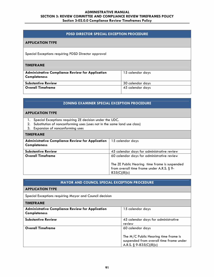
ADMINISTRATIVE MANUAL SECTION 3: REVIEW COMMITTEE AND COMPLIANCE REVIEW TIMEFRAMES POLICY
Section 3-02.0.0 Compliance Review Timeframes Policy
91
PDSD DIRECTOR SPECIAL EXCEPTION PROCEDURE
APPLICATION TYPE
Special Exceptions requiring PDSD Director approval
TIMEFRAME
Administrative Compliance Review for Application Completeness
15 calendar days
Substantive Review 30 calendar days Overall Timeframe
45 calendar days
ZONING EXAMINER SPECIAL EXCEPTION PROCEDURE
APPLICATION TYPE
1. Special Exceptions requiring ZE decision under the UDC. 2. Substitution of nonconforming uses (uses not in the same land use class) 3. Expansion of nonconforming uses
TIMEFRAME
Administrative Compliance Review for Application Completeness
15 calendar days
Substantive Review 45 calendar days for administrative review Overall Timeframe
60 calendar days for administrative review The ZE Public Hearing time frame is suspended from overall time frame under A.R.S. § 9-835(C)(8)(c)
MAYOR AND COUNCIL SPECIAL EXCEPTION PROCEDURE
APPLICATION TYPE
Special Exceptions requiring Mayor and Council decision
TIMEFRAME
Administrative Compliance Review for Application Completeness
15 calendar days
Substantive Review 45 calendar days for administrative review
Overall Timeframe
60 calendar days The M/C Public Hearing time frame is suspended from overall time frame under A.R.S. § 9-835(C)(8)(c)

ADMINISTRATIVE MANUAL SECTION 3: REVIEW COMMITTEE AND COMPLIANCE REVIEW TIMEFRAMES POLICY
Section 3-03.0.0 Flexible Application Process
92
3-03.0.0 FLEXIBLE APPLICATION PROCESS 3-03.1.0 GENERAL 3-03.2.0 DESCRIPTION OF PROCESSES TABLE 3-03 TYPICAL TIMEFRAMES FOR COMPLIANCE REVIEW/FLEXIBLE OPTION 3-03.1.0 GENERAL
In 2011 the Arizona Legislature passed a “Regulatory Bill of Rights” (SB 1598) requiring municipalities to establish and adhere to time frames in a broad range of permitting processes. Under the law cities must create an overall permitting time frame for each process, consisting of an “administrative completeness” time frame and a “substantive review” time frame. The aim of this bill was to create faster, more uniform, and more transparent processes, goals which the City of Tucson Planning and Development Services Department (PDSD) share. However, the implementation of these time frames may have unforeseen consequences. Under the SB 1598 regulatory-limits process, the CCity must determine whether a permit application is complete or not during the administrative completeness time frame. If the CCity fails to make this determination within established time limits, the permit is deemed complete regardless of deficiencies. Similarly during the substantive review period an application must be denied or approved within the established time frame or the permit fee will be refunded. The SB 1598 regulatory-limits process offers applicants very limited opportunities to supplement their application with additional material after submission. Moreover, changes to a permit application are limited to responses to a PDSD request. Development changes proposed by the applicant do not appear to be allowed. Upon proper denial, during either review period, applicants must reapply with new plans and pay another permit fee. PDSD is committed to customer service and recognizes that applicants may not wish to be locked into formulaic standards which do not provide an adequate opportunity to submit additional requested materials and desired plan changes. Thus, PDSD offers applicants the opportunity to make permit applications according to either the SB 1598 regulatory-limits process or the more flexible process City of Tucson PDSD customers are familiar with.
Under the flexible application process, applicants have multiple opportunities to alter or amend their application and to confer with City staff for advice. This allows the applicant to adjust plans based on their own changing development circumstances over time or on suggestions by staff. Additionally, applicants may alter their permit applications as many times as necessary during the process. Applicants are encouraged to carefully consider which application process best meets their needs. Staff can explain the processes in more detail upon request as well as provide you a copy of SB 1598. The following points outline some of the highlights of each process:

ADMINISTRATIVE MANUAL SECTION 3: REVIEW COMMITTEE AND COMPLIANCE REVIEW TIMEFRAMES POLICY
Section 3-03.0.0 Flexible Application Process
93
3-03.2.0 DESCRIPTION OF PROCESSES
2.1 “Regulatory Limits Application Process”
A. A limited number of opportunities to confer with staff and supply necessary information and materials. PDSD may request additional information only once after the application is deemed administratively complete.
B. If City fails to meet established timeframe for review, an application may be deemed complete although lacking essential materials. If an application is not timely approved or denied fees are refunded to the applicant.
C. During review period applicant may lose opportunity to propose alterations to support permit approval or changes in circumstance during development.
D. If permit properly denied after PDSD one-time request for more information, applicant must reapply and pay new fee.
E. Denials must be explained and the applicable code provisions identified F. Applicant may request code clarification.
2.2 “Flexible Application Process”
A. Multiple application conferences available before submittal and during process. B. During review period applicant may propose changes to support permit approval
and substantial and multiple changes may be made without reapplication. C. Same review timeframes as currently applied for the different application types.
(see Table 3-03 below). D. No refund for a review period longer than the established timeframe. However,
PDSD meets or exceeds established permit review period in 85-90% of applications. Complex applications or substantial changes may take longer.
E. Denials will be explained and the applicable code provisions identified F. Applicant may request code clarification.

ADMINISTRATIVE MANUAL SECTION 3: REVIEW COMMITTEE AND COMPLIANCE REVIEW TIMEFRAMES POLICY
Section 3-03.0.0 Flexible Application Process
94
TABLE 3-03 TYPICAL TIMEFRAMES FOR COMPLIANCE REVIEW/FLEXIBLE OPTION
PDSD DIRECTOR APPROVAL PROCEDURE
APPLICATION TYPES 1. Business licenses; 2. Changes of use; 3. Downtown Area Infill Incentive District – projects within the Downtown Core Sub-district requesting a
modification of development regulations (Note: projects within the Greater Infill Incentive Sub district are processed in accordance with the 300’ Notice Procedure below);
4. Electrical connections (certain types); 5. Expansion of existing premises; 6. Home occupations; 7. Individual Parking Plans for projects greater than 300’ from R-3 or more restrictive zoning districts; 8. New construction; 9. Nonconforming same Land Use Class substitution; 10. Nonconforming parking areas; 11. Parking Design Modification Requests (except requests to modify the number of bicycle or motor
vehicle parking spaces); 12. Projects within certain overlay zones; 13. Restricted adult activities; 14. Temporary uses or structures; 15. Tenant improvements; 16. Wireless Communication uses (certain types); 17. Rio Nuevo District Zone Minor Modifications of Development Regulations (MDR); 18. Zoning Compliance for Site Improvements in Existence on May 1, 2005; 19. Other applications, such as blood donor centers and circus, carnival and tent shows; 20. Site plans (Site plans in Overlay Districts require different time frames for review); 21. Subdivision tentative plat; 22. Subdivision final plat; and,
TIMEFRAME
Administrative Compliance Review for Application Completeness
10 working days
For applications that do not require a site plan or a subdivision plat : 10 working days, or 5 working days after the date of submittal of a required recommendation by a special reviewer, board or committee. Thereafter, the same review period after each re-submittal.
Substantive Review
For applications that require a site plan or subdivision plat: 20 calendar days. Thereafter 20 calendar days for each re-submittal. For application that do not require a site plan or subdivision plat: 14 calendar days
Substantive Review
For applications that require a site plan or subdivision plat: 20 to 60 calendar days or more, depending upon the number of re-submittals

ADMINISTRATIVE MANUAL SECTION 3: REVIEW COMMITTEE AND COMPLIANCE REVIEW TIMEFRAMES POLICY
Section 3-03.0.0 Flexible Application Process
95
PDSD DIRECTOR APPROVAL PROCEDURE: 50’ NOTICE PROCEDURE
APPLICATION TYPES
1. Design Development Options (DDO) in accordance; 2. Parking Design Modification Requests to the required number of bicycle and motor vehicle parking
spaces; 3. PDSD Director Special Exception applications; 4. Approval of resident artisan uses in the Historic Preservation Zone; 5. Certain wireless facilities; 6. Requests for demolition of contributing, non-historic structures in the HPZ
TIMEFRAME
Administrative Compliance Review for Application Completeness
10 working days
Substantive Review 30 calendar days
Overall Timeframe
40 calendar days
PDSD DIRECTOR APPROVAL PROCEDURE 300’ NOTICE PROCEDURE
APPLICATION TYPES
1. Mitigation plans for certain restaurants serving alcohol within 300 feet of R-3 or more restrictive zoning;
2. Projects within the Greater Infill Incentive Subdistrict of the Downtown Area Infill Incentive District requesting a Modification of Development Regulations; and,
3. Individual Parking Plans for projects within 300 feet of R-3 or more restrictive zoning districts.
TIMEFRAME
Administrative Compliance Review for Application Completeness
10 working days
Substantive Review 45 calendar days
Overall Timeframe
55 calendar days

ADMINISTRATIVE MANUAL SECTION 3: REVIEW COMMITTEE AND COMPLIANCE REVIEW TIMEFRAMES POLICY
Section 3-03.0.0 Flexible Application Process
96
ZONING ADMINISTRATOR APPROVAL PROCEDURE
APPLICATION TYPES
1. Compliance with certification of existing premises; 2. Interpretations of the UDC; 3. Planned Area Development interpretations; and, 4. Zone boundary conflicts.
TIMEFRAME
Administrative Compliance Review for Application Completeness
10 working days
Substantive Review 5 working days for most applications Additional time is required for complex issues or interpretations that require a City Attorney legal opinion. 20-30 calendar days
Overall Timeframe
10 working days for most applications
For complex issues of interpretations that require a City Attorney legal opinion,
30 - 40 calendar days

ADMINISTRATIVE MANUAL SECTION 3: REVIEW COMMITTEE AND COMPLIANCE REVIEW TIMEFRAMES POLICY
Section 3-03.0.0 Flexible Application Process
97
PDSD DIRECTOR APPROVAL IN CERTAIN OVERLAY ZONES
APPLICATION TYPE
Historic Preservation Zone Design Review
TIMEFRAME
Administrative Compliance Review for Application Completeness
10 working days
Substantive Review: Full Review Minor Review
45 calendar days 30 calendar days
Overall Timeframe: Full Review Minor Review
55 calendar days 40 calendar days
APPLICATION TYPE
Rio Nuevo District Design Review
TIMEFRAME
Administrative Compliance Review for Application Completeness
10 working days
Substantive Review: Major Minor
70 calendar days 55 calendar days
Overall Timeframe: Major Review Minor Review
80 calendar days 55 calendar days
APPLICATION TYPE
Neighborhood Preservation Zone Design Review
TIMEFRAME
Administrative Compliance Review for Application Completeness
10 calendar days
Substantive Review 20 calendar days
Overall Timeframe
30 calendar days
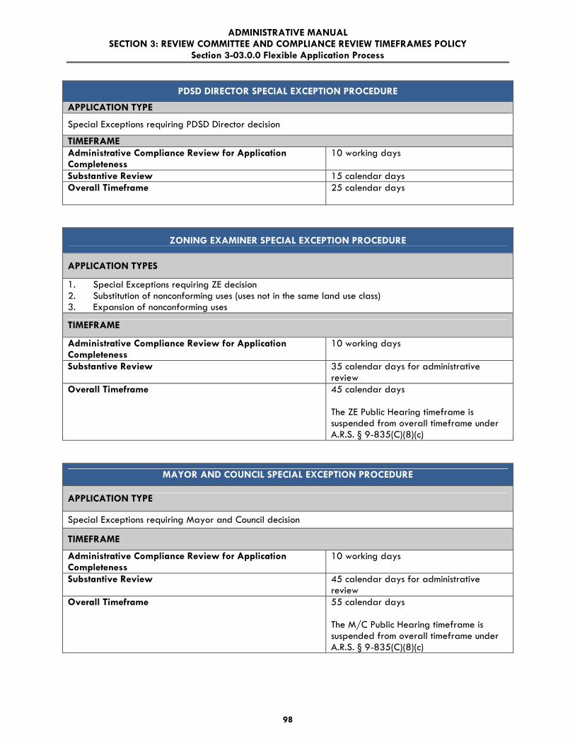
ADMINISTRATIVE MANUAL SECTION 3: REVIEW COMMITTEE AND COMPLIANCE REVIEW TIMEFRAMES POLICY
Section 3-03.0.0 Flexible Application Process
98
PDSD DIRECTOR SPECIAL EXCEPTION PROCEDURE
APPLICATION TYPE
Special Exceptions requiring PDSD Director decision
TIMEFRAME Administrative Compliance Review for Application Completeness
10 working days
Substantive Review 15 calendar days Overall Timeframe
25 calendar days
ZONING EXAMINER SPECIAL EXCEPTION PROCEDURE
APPLICATION TYPES
1. Special Exceptions requiring ZE decision 2. Substitution of nonconforming uses (uses not in the same land use class) 3. Expansion of nonconforming uses
TIMEFRAME
Administrative Compliance Review for Application Completeness
10 working days
Substantive Review 35 calendar days for administrative review
Overall Timeframe
45 calendar days The ZE Public Hearing timeframe is suspended from overall timeframe under A.R.S. § 9-835(C)(8)(c)
MAYOR AND COUNCIL SPECIAL EXCEPTION PROCEDURE
APPLICATION TYPE
Special Exceptions requiring Mayor and Council decision
TIMEFRAME
Administrative Compliance Review for Application Completeness
10 working days
Substantive Review 45 calendar days for administrative review
Overall Timeframe
55 calendar days The M/C Public Hearing timeframe is suspended from overall timeframe under A.R.S. § 9-835(C)(8)(c)

ADMINISTRATIVE MANUAL SECTION 4: DEVELOPMENT REVIEW FEE SCHEDULE
99
SECTION 4: DEVELOPMENT REVIEW FEE SCHEDULE

ADMINISTRATIVE MANUAL SECTION 4: DEVELOPMENT REVIEW FEE SCHEDULE Section 4-01.0.0 Development Review Fee Schedule
100
4-01.0.0 DEVELOPMENT REVIEW FEE SCHEDULE
4-01.1.0 GENERAL
4-01.2.0 ADMINISTRATIVE AND RECORDS FEES
4-01.3.0 APPEAL FEES
4-01.4.0 RESERVED [FOR ASSURANCES (SUBSTITUTION OF)]
4-01.5.0 BUILDING PLAN REVIEW AND PERMIT FEES
4-01.6.0 CERTIFICATE OF OCCUPANCY AND OTHER MISCELLANEOUS BUILDING PERMIT FEES
4-01.7.0 CHANGE OF ZONING FEES
4-01.8.0 DEMOLITION FEES
4-01.9.0 MANUFACTURED HOME (MH) AND RECREATIONAL (RV) SPACES FEES
4-01.10.0 MEDICAL MARIJUANA CULTIVATION AND DISPENSARY APPLICATION FEES
4-01.11.0 MODIFICATION AND IN-LIEU FEES
4-01.12.0 PLAN AMENDMENT FEES
4-01.13.0 PRIVATE IMPROVEMENT FEES
4-01.14.0 PROTECTED DEVELOPMENT RIGHT PLAN FEES
4-01.15.0 SIGN REVIEW AND PERMIT FEES
4-01.16.0 SITE PLAN REVIEW FEES
4-01.17.0 SPECIAL DISTRICT REVIEW FEES
4-01.18.0 SPECIAL EXCEPTION LAND USE FEES
4-01.19.0 SUBDIVISION PLAT FEES
4-01.20.0 TEMPORARY USE PERMIT (TUP) FEE
4-01.21.0 VARIANCE FEES – BOARD OF ADJUSTMENT (B/A) FEES
4-01.22.0 ZONING DETERMINATION, CERTIFICATION OF ZONING, NONCONFORMING USE
(CONFIRMATION AND SUBSTITUTION) FEES
4-01.1.0 GENERAL
1.1 Purpose The purpose of this Standard is to establish appropriate fees which are assessed by the City for development of land within the City of Tucson.
1.2 Policy
The Tucson Code authorizes the City Manager to establish fees with approval by the Mayor and Council. Under Mayor and Council policy, each City of Tucson fee was approved after public hearing.

ADMINISTRATIVE MANUAL SECTION 4: DEVELOPMENT REVIEW FEE SCHEDULE Section 4-01.0.0 Development Review Fee Schedule
101
1.3 General, Applicable to All Fees
A. All fees are collected at the time the application is filed.
B. All fees are payable to the “City of Tucson.”
C. Planning and Development Services Department Zoning fees may be waived for a governmental agency by the City Manager.
D. Any request to vary, waive, or appeal a Planning and Development Services Department fee (other than Zoning fees) is decided by the Mayor and Council.
E. Requests by potential applicants for notification lists for the various review procedures, for their private use, shall be accompanied by a fee which is assessed according to the following schedule. If the list was requested prior to the filing of an official application for a Planning and Development Services Department review process, which requires public notification, the notification fee will not be charged at the time of application provided the list is less than thirty (30) days old at the time of application.
Notification area surrounding the subject site ................................................... $220.00
F. In calculating fees which are based on acreage, the acreage is to be rounded off to the nearest hundredth of an acre.
G. Variable Fees. In the fee schedule, when a fee amount is listed as variable, please call the Planning Development Services Department at 791-5550 for the current fee. These fees are listed as variable, because they can vary from case to case or because they are fees paid to an outside vendor. For example:
1. Current Aerial Photograph Fee. This fee is based on an annual contract with a private aerial photography firm.
2. Legal Advertisement. This fee covers the cost of advertisement in a newspaper of general circulation and is dependent upon the amount charged by the outside vendor.
3. Ordinance Display Ad or Resolution Display Ad. This fee covers the cost of publishing the ordinance or resolution in a newspaper of general circulation, should the ordinance or resolution be adopted.
1.4 Amendments to the Development Review Fee Schedule
Amendments to the Development Review Fee Schedule requires approval by the Mayor and Council.
4-01.2.0 ADMINISTRATIVE AND RECORDS FEES
2.1 Advanced Payment Account (APA)
A. APA Processing In Person………………………… ……………….…. $0.55 B. APA Processing – Telephone or Fax request…………………………...$4.95 C. APA Mail Fee…………………………………………………………..$1.65

ADMINISTRATIVE MANUAL SECTION 4: DEVELOPMENT REVIEW FEE SCHEDULE Section 4-01.0.0 Development Review Fee Schedule
102
2.2 Copy and Print Charges
A. Photocopy (One Copy)………………………….………………………..$1.10 Additional Copies……………………………………$0.27 per page B. Blue Line Reproduction Fee………….………………………….$1.65 per page C. E-Plans………………………….……………………………….$4.95 per sheet D. 16mm film……………….……………………………………….$1.65 per copy E. 33mm film……………………………………………………… $2.20 per copy
2.3 Computer Generated Reports
A. Standard Weekly Report, each…………………………. $27.50
B. Standard Monthly Report, each…………………………. $44.00
C. Standard Yearly Report, each…………………………... $220.00
D. Customization or analysis of report information, per
hour……………………………………………………… $55.00 (1 hour minimum fee)
2.4 Expedited Project Review Fee………………………………200% of standard review
fee 2.5 RESERVED (for Revision Fee fee)
2.6 Technology/Archive Fee*….… $16.50 or 1% of the total filing fee, whichever is greater
* The Technology/Archive Fee applies to the following application types: Appeals; Building Plans; Certification of Zoning; Change of Zoning (Rezoning); Confirmation of Nonconforming Use; Design Development Option; Electrical Permits; Design Review Board; Fuel Tank Permits; Grading Permits; Historic Preservation Zone (Minor and Major Reviews); Manufactured Home Permits; Mechanical Permits; Medical Marijuana Cultivation and Dispensary applications; Modification of Development Requirements in the Rio Nuevo District and Downtown Area Infill Incentive District; Plan Amendments; Plumbing Permits; Private Improvement Plans; Protected Development Rights; Sign Permits; Special Exceptions; Subdivision Plats; Substitution of Nonconforming Use; Temporary Use Permit; Tent and Canopy Permits; Variances; and, Zoning Administrator Determinations
2.7 Optional Dispute Resolution Process Fee...............................Subject to current City Contract

ADMINISTRATIVE MANUAL SECTION 4: DEVELOPMENT REVIEW FEE SCHEDULE Section 4-01.0.0 Development Review Fee Schedule
103
4-01.3.0 APPEAL FEES
3.1 Appeal of Decision to the Board of Adjustment
A. Staff Review Fee…...…………………………………………….………..Variable
B. Legal Advertisement ............................................................................................... Variable
C. Notification as Required......................................................................................... $220.00
3.2 Appeal of Decision to Mayor and Council
A. Staff Review Fee……………………………...………………….………..Variable
B. Legal Advertisement ............................................................................................... Variable
C. Notification as Required......................................................................................... $220.00
3.3 Appeal of PDSD Director Decision on an NPZ Design Review Application to the Design
Review Board
A. Staff Review………………………………..……………………….…………$80 B. Notification as required……….………………..……………...............................$37
3.4 Board of Appeals Filing Fee Every applicant will pay a non-refundable fee when filing…………………….…$264.00
3.5 Building Official Appeal Filing Fee Every applicant will pay a nonrefundable fee when filing………………..…….…$132.00
4-01.4.0 RESERVED [for Assurances (Substitution of) fee]
4-01.5.0 BUILDING PLAN REVIEW AND PERMIT FEES
5.1 Building Plan Review and Permit Fees
A. Building Plan Review Fees
1. Building plan review fees and deferred submittal fees per 2006 IBC Amendments Section 108.53.1 are 65% of the building permit fee for commercial buildings.
2. Building plan review fees and deferred submittal fees per 2006 IBC Amendments Section 108.53.1 are 50% of the building permit fee for residential buildings (Group R-3 and U Occupancies.)
3. Model building plan review fees (for Group R-3 or U Occupancies or Swimming Pools) is 50% of the building permit fees plus $23.00 for each additional exterior design elevation. The plan review fee for each subsequent use of this model plan within 12 months of model plan approval will not exceed $55.00.
4. No plan review fees for electrical, mechanical, and plumbing work will be charged when application for all permits (building, electrical, mechanical, and plumbing) are made in one application.

ADMINISTRATIVE MANUAL SECTION 4: DEVELOPMENT REVIEW FEE SCHEDULE Section 4-01.0.0 Development Review Fee Schedule
104
B. Building Permit Fees
Total Valuation Fee
$1.00 to $500.00 $28.60
$500.01 to $2,000.00 $28.60 for the first $500.00, plus $3.63 for each additional $100.00, or fraction thereof, to and including $2,000.00
$2,000.01 to $25,000.00 $83.60 for the first $2,000.00, plus $16.50 for each additional $1,000.00, or fraction thereof, to and including $25,000.00
$25,000.01 to $50,000.00 $467.50 for the first $25,000.00, plus $12.10 for each additional $1,000.00, or fraction thereof, to and including $50,000.00
$50,000.01 to $100,000.00 $770.00 for the first $50,000.00, plus $8.80 for each additional $1,000.00, or fraction thereof, to and including $100,000.00
$100,000.01 to $500,000.00 $1,210 for the first $100,000.00, plus $6.60 for each additional $1,000.00, or fraction thereof, to and including $500,000.00
$500,000.01 to $1,000,000.00 $3,850 for the first $500,000.00, plus $5.61 for each additional $1,000.00, or fraction thereof, to and including $1,000,000.00
$1,000,000.01 and above $6,765.00 for the first $1,000,000.00, plus $4.51 for each additional $1,000.00, or fraction thereof
C. Other Inspections and Fees
Inspection Fee
Inspections outside of normal business hours
(minimum charge – 2 hours) $59.40 *
Reinspection fees assessed under provisions of 2006 IBC Amendment 108.5.2 $59.40 *
Inspections for which no fee is specifically indicated
(minimum charge – ½ hour) $59.40 *
Additional plan review required by changes, additions, or revisions to plans (minimum charge – ½ hour) $59.40 *
For use of outside consultants for plan checking and inspections, or both Actual Costs **
Housing Code compliance inspections under provision of Section 16-27 of The Neighborhood Protection Ordinance, each $95.70

ADMINISTRATIVE MANUAL SECTION 4: DEVELOPMENT REVIEW FEE SCHEDULE Section 4-01.0.0 Development Review Fee Schedule
105
* Or the total hourly cost to the jurisdiction, whichever is the greatest. This cost shall include supervision, overhead, equipment, and hourly wages and fringe benefits of the employees involved.
** Actual costs include administrative and overhead costs.
5.2 Electrical Plan Review and Permit Fees
A. Electrical Plan Review Fees
The plan review fee for electrical permits is 25% of the total electrical permit fee.
B. Electrical Permit Fees
1. Permit Issuance
a. For the issuance of each electrical permit ...................................$28.60
b. For the issuance of each supplemental permit for which the original permit has not expired, been cancelled, or finaled.................... $8.80
2. System Fee Schedule
(Note: The following do not include permit-issuance fee.)
a. New Residential Buildings
The following fees shall include all wiring and electrical equipment in or on each building or other electrical equipment on the same premises constructed at the same time.
Multifamily. For new multifamily buildings (apartments and condominiums) having three or more dwelling units constructed at the same time, not including the area of garages, carports, and accessory buildings, per square foot (0.09 m2) ..........................$0.061
Single- and two-family. For new single- and two-family residential buildings constructed at the same time, not including the area of garages, carports, and accessory buildings, per square foot (0.09 m2) .............................................................................................$0.067
For other types of residential occupancies and for alternations, additions and modifications to existing residential buildings, use the Unit Fee Schedule.
b. Private Swimming Pools
For new private, in-ground swimming pools for single-family and multifamily occupancies, including a complete system of necessary branch circuit wiring, bonding, grounding, under-water lighting, water pumping, and other similar electrical equipment directly related to the operation of a swimming pool, each pool ..........................................................................................................$59.40 *
c. Carnivals and Circuses
Carnivals, circuses, or other traveling shows or exhibitions utilizing transportable-type rides, booths, displays and attractions.
For electrical generators and electrically driven rides, each..$28.60

ADMINISTRATIVE MANUAL SECTION 4: DEVELOPMENT REVIEW FEE SCHEDULE Section 4-01.0.0 Development Review Fee Schedule
106
For mechanically driven rides and walk-through attractions or displays having electric lighting, each ........................................... $8.80
For permanently installed rides, booths, displays and attractions. .................................................................................. See Unit Fee Schedule
d. Temporary Power Service
For a temporary service pole or pedestal, including all pole or pedestal-mounted receptacle outlets and appurtenances, each .............................................................................................................$28.60
For a temporary distribution system and temporary lighting and receptacle outlets for construction sites, decorative lights, Christmas tree sales lots, fireworks stands, etc., each .................................$14.30
3. Unit Fee Schedule
(Note: The following do not include permit-issuance fee.)
a. Receptacle, Switch, and Light Outlets
For receptacle, switch, light, or other outlets at which current is used or controlled, except services, feeds, and meters:
First 20 fixtures, each ........................................................................ $1.32
Additional fixtures, each................................................................... $0.88
Note: For multioutlet assemblies, each 5 feet (1,524 mm) or fraction thereof may be considered as one outlet.
b. Lighting Fixtures
For lighting fixtures, sockets, or other lamp-holding devices:
First 20 fixtures, each ........................................................................ $1.32
Additional fixtures, each................................................................... $0.88
For pole or platform-mounted lighting fixtures, each................. $1.32
For theatrical –type lighting fixtures or assemblies, each ......... $1.32
c. Residential Appliances
For fixed residential appliances or receptacle outlets for same, including wall-mounted electric ovens; counter-mounted cooking tops; electric ranges; self-contained room, console, or through-wall air conditioners; space heaters; food waste grinders; dishwashers; washing machines; water heaters; clothes dryers; or other motor-operated appliances not exceeding 1 horsepower (HP) (746W) in rating, each.......................................................................................... $5.50
Note: For other types of air conditioners and other motor-driver appliances having larger electrical ratings, see Power Apparatus.

ADMINISTRATIVE MANUAL SECTION 4: DEVELOPMENT REVIEW FEE SCHEDULE Section 4-01.0.0 Development Review Fee Schedule
107
d. Nonresidential Appliances
For nonresidential appliances and self-contained factory-wired nonresidential appliances not exceeding 1 horsepower (HP), kilowatt (kW), or kilovolt-ampere (kVA), in rating, including medical and dental devises; food, beverage, and ice cream cabinets; illuminated show cases; drinking fountains; vending machines; laundry machines; or other similar types of equipment, each ............................................................................................................... $5.50
Note: For other types of air conditioners and other motor-driver appliances having larger electrical ratings, see Power Apparatus.
e. Power Apparatus
For motors, generators, transformers, rectifiers, synchronous converters, capacitors, industrial heating, air conditioners and heat pumps, cooking or baking equipment, and other apparatus, as follows:
Rating in horsepower (HP), kilowatts (kW) , kilovolt-amperes (kVA), or kilovolt amperes-reactive (kVAR):
Up to and including 1, each ............................................................. $5.50
Over 1 and not over 10, each ......................................................$14.30
Over 10 and not over 50, each....................................................$29.70
Over 50 and not over 100, each .................................................$59.40
Over 100, each ................................................................................$89.10
Notes:
1. For equipment or appliances having more than one motor, transformer, heater, etc., the sum of the combined ratings may be used.
2. These fees include all switches, circuit breakers, contactors, thermostats, relays and other directly related control equipment.
f. Busways
For trolley and plug-in type busways, each 100 feet (30480mm) or fraction thereof................................................................................... $8.80
Note: An additional fee is required for lighting fixtures, motors, and other appliances that are connected to trolley and plug-in type busways. A fee is not required for portable tools.
g. Signs, Outline Lighting, and Marquees
For signs, outline lighting systems, or marquees supplied from one branch circuit, each ..........................................................................$29.70

ADMINISTRATIVE MANUAL SECTION 4: DEVELOPMENT REVIEW FEE SCHEDULE Section 4-01.0.0 Development Review Fee Schedule
108
For additional branch circuits within the same sign, outline lighting systems, or marquee, each ............................................................... $5.50
h. Services
For services of 600 volts or less and not over 200 amperes in rating, each………………………………………………………$36.30
For services of 600 volts or less and over 200 amperes 1,000 amperes in rating, each ..................................................................$74.80
For services over 600 volts or over 1,000 amperes in rating, each .......................................................................................................... $149.60
i. Miscellaneous Apparatus, Conduits and Conductors
For electrical apparatus, conduits and conductors for which a permit is required but for which no fee is herein set forth....................$22.00
Note: This fee is not applicable when a fee is paid for one or more services, outlets, fixtures, appliances, power apparatus, busways, signs or other equipment.
C. Other Inspections and Fees
1. Inspections outside of normal business hours, per hour (minimum charge – two hours) ...................................................................................................$59.40 *
2. Reinspection fees assessed under provisions of Section 305.8, per inspection....................................................................................................$59.40 *
3. Inspections for which no fee is specifically indicated, per hour (minimum charge – one half hour)...........................................................................$59.40 *
4. Additional plan review required by changes, additions, or revisions to plans for which an initial review has been completed (minimum charge – one half hour) ............................................................................................$59.40 *
* Or the total hourly cost to the jurisdiction, whichever is greatest. This cost shall include supervision, overhead, equipment and hourly wages and fringe benefits of the employees involved.
5.3 Mechanical Plan Review and Permit Fees
A. Mechanical Plan Review Fees
The plan review fee for mechanical permits is 25% of the total mechanical permit fee.
B. Mechanical Permit Fees
1. Permit Issuance and Heaters
a. For the issuance of each mechanical permit................................$28.60
b. For issuing each supplemental permit for which the original permit has not expired, been canceled, or finaled.................................. $8.80

ADMINISTRATIVE MANUAL SECTION 4: DEVELOPMENT REVIEW FEE SCHEDULE Section 4-01.0.0 Development Review Fee Schedule
109
2. Unit Fee Schedule
(Note: The following do not include permit issuance fees.)
a. Furnaces
For the installation or relocation of each forced-air or gravity-type furnace or burner, including ducts and vents attached to such appliance, up to and including 100,000 Btu/h (29.3kW).......$17.60
For the installation or relocation of each forced-air or gravity-type furnace or burner, including ducts and vents attached to such appliance over 100,000 Btu/h (29.3kW) ..................................$22.00
For the installation or relocation of each suspended heater, recessed wall heater or floor-mounted unit heater...................$17.60
For the installation or relocation of each suspended heater, recessed wall heater or floor-mounted unit heater...................$17.60
b. Appliance Vents
For the installation, relocation, or replacement of each appliance vent installed and not included in an appliance permit ............. $8.80
c. Repairs or Additions
For the repair of, alternation of, or addition to each heating appliance, refrigeration, cooling unit, absorption unit, or each heating, cooling, absorption or evaporative cooling system, including installation of controls regulated by the Mechanical Code .............................................................................................................$16.50
d. Boilers, Compressors, and Absorption Systems
For the installation or relocation of each boiler or compressor to and including 3 horsepower (10.6 kW) or each absorption system to and including 100,000 Btu/h (29.3 kW)................................$17.60
For the installation or relocation of each boiler or compressor over 3 horsepower (10.6 kW) to and including 15 horsepower (52.7 kW) or each absorption system over 100,000 Btu/h (29.3 kW) to and including 500,000 Btu/h (146.6 kW)..................................$33.00
For the installation or relocation of each boiler or compressor over 15 horsepower (52.7 kW) to and including 30 horsepower (105.5 kW) or each absorption system over 500,000 Btu/h (146.6 kW) to and including 1,000,000 Btu/h (293.1 kW) ..............................$45.10
For the installation or relocation of each boiler or compressor over 30 horsepower (105.5 kW) to and including 50 horsepower (175 kW) or each absorption system over 1,000,000 Btu/h (293.1 kW) to and including 1,750,000 Btu/h (512.9 kW) .........................$67.10
For the installation or relocation of each boiler or compressor over 50 horsepower (176 kW) or each absorption system over 1,750,000 Btu/h (512.9 kW)..................................................... $110.00

ADMINISTRATIVE MANUAL SECTION 4: DEVELOPMENT REVIEW FEE SCHEDULE Section 4-01.0.0 Development Review Fee Schedule
110
e. Air Handlers
For each air-handling unit to and including 10,000 cubic feet per minute (cfm) (4719 L/s), including ducts attached thereto.......$13.20
For each air-handling unit over 10,000 cfm (4719L/s)………$22.00
Note: This fee does not apply to an air-handling unit which is a portion of a factory-assembled appliance, cooling unit, evaporative cooler or absorption unit for which a permit is required elsewhere in the Mechanical Code.
f. Evaporative Coolers
For each evaporative cooler other than portable type ...........$13.20
g. Ventilation and Exhaust
For each ventilation fan connected to a single duct .................... $8.80
For each ventilation system which is not a portion of any heating or air-conditioning system authorized by a permit ........................$13.20
For the installation of each hood which is served by mechanical exhaust, including the ducts for such hood...................................$13.20
h. Incinerators
For the installation or relocation of each domestic-type incinerator .............................................................................................................$22.00
For the installation or relocation of each commercial or industrial-type incinerator ................................................................................$17.60
i. Miscellaneous
For each appliance or piece of equipment regulated by the Mechanical Code but not classed in other appliance categories or for which no other fee is listed in the table.................................$13.20
C. Other Inspections and Fees
1. Inspections outside of normal business hours, per hour (minimum charge – two hours) ...................................................................................................$59.40 *
2. Reinspection fees assessed under provisions of Section 305.8, per inspection....................................................................................................$59.40 *
3. Inspections for which no fee is specifically indicated, per hour (minimum charge – one half hour)...........................................................................$59.40 *
4. Additional plan review required by changes, additions, or revisions to plans for which an initial review has been completed (minimum charge – one half hour) ............................................................................................$59.40 *
* Or the total hourly cost to the jurisdiction, whichever is greatest. This cost shall include supervision, overhead, equipment, hourly wages and fringe benefits of the employees involved.

ADMINISTRATIVE MANUAL SECTION 4: DEVELOPMENT REVIEW FEE SCHEDULE Section 4-01.0.0 Development Review Fee Schedule
111
5.4 Plumbing Plan Review and Permit Fees
A. Plumbing Plan Review Fees
The plan review fee for plumbing permits is 25% of the total plumbing permit fee.
B. Plumbing Permit Fees
1. Permit Issuance
a. For the issuance of each plumbing permit ...................................$28.60
b. For issuing each supplemental permit for which the original permit has not expired, been canceled, or finalized............................... $8.80
2. Unit Fee Schedule
(Note: The following do not include permit issuance fees.)
a. Fixtures and Vents
For each plumbing fixture or trap or set of fixtures on one trap (including water, drainage piping, and backflow protection thereof) .............................................................................................................$12.10
For repair or alteration of drainage or vent piping, each fixture ……………………………………………………………...$5.50
b. Sewers, Disposal Systems and Interceptors
For each building sewer and each trailer park sewer .............$29.70
For each cesspool .............................................................................$45.10
For each private sewage disposal system ..................................$89.10
For each industrial waste pretreatment interceptor, including its trap and vent, excepting kitchen-type grease interceptors functioning as fixture traps.......................................................................................$24.20
Rainwater system – per drain (inside building)..........................$12.10
c. Water Piping and Water Heaters
For installation, alteration, or repair of water piping or water-treating equipment, or both, each .................................................. $5.50
For each water heater including vent...........................................$14.30
For vents only, see above
d. Gas Piping Systems
For each gas piping system of one to five outlets ....................... $7.70
For each additional outlet over five, each .................................... $1.32

ADMINISTRATIVE MANUAL SECTION 4: DEVELOPMENT REVIEW FEE SCHEDULE Section 4-01.0.0 Development Review Fee Schedule
112
e. Lawn Sprinklers, Vacuum Beakers and Backflow Protection Devices
For each lawn sprinkler system on any one meter, including backflow protection devices thereof ............................................$17.60
For atmospheric-type vacuum breakers or backflow protection devises not included in item 1.
1 to 5 devices ...................................................................................$14.30
Over 5 devices, each......................................................................... $2.64
2 inches (50.8mm) and smaller......................................................$14.30
Over 2 inches (50.8mm)..................................................................$29.70
f. Swimming Pools
For each swimming pool or spa:
Public pool ...................................................................................... $110.00
Public spa...........................................................................................$72.60
Private pool .......................................................................................$72.60
Private spa.........................................................................................$36.30
g. Miscellaneous
For each appliance or piece of equipment of regulated by the Plumbing Code but not classed in other appliance categories or for which no other fee is listed in this code........................................$12.10
C. Other Inspections and Fees
1. Inspections outside of normal business hours, per hour (minimum charge – two hours) ...................................................................................................$59.40 *
2. Reinspection fees assessed under provisions of Section 305.8, per inspection....................................................................................................$59.40 *
3. Inspections for which no fee is specifically indicated, per hour (minimum charge – one half hour)...........................................................................$59.40 *
4. Additional plan review required by changes, additions, or revisions to plans for which an initial review has been completed (minimum charge – one half hour) ............................................................................................$59.40 *
* Or the total hourly cost to the jurisdiction, whichever is greatest. This cost shall include supervision, overhead, equipment, hourly wages and fringe benefits of the employees involved.
5.5 Grading Plan Review and Permit Fees
A. First Review: Per sheet (twenty-four (24) by thirty six (36) inches (includes one back check)............…….……………………………………………….…..$201.30
B. Additional plan review required by changes, additions, or revisions to plans or to plans for which an initial review and one back-check has been completed…………………………………………………………………$59.40*

ADMINISTRATIVE MANUAL SECTION 4: DEVELOPMENT REVIEW FEE SCHEDULE Section 4-01.0.0 Development Review Fee Schedule
113
* Or the total hourly cost to the jurisdiction, whichever is greatest. This cost shall include supervision, overhead, equipment, hourly wages and fringe benefits of the employees involved.
C. Grading Permit Fees
The fee for a grading permit authorizing additional work to that under a valid permit shall be the difference between the fee paid for the original permit and the fee shown for the entire project.
Or the total hourly cost to the jurisdiction, whichever is greatest. This cost shall include supervision, overhead, equipment, hourly wages and fringe benefits of the employees involved.
Area Fee
1 to 1,000 cubic yards $88.00 for the first 100 cubic yards, plus $33.00 for each additional 100 cubic yards or fraction thereof
1,001 to 10,000 cubic yards $385.00 for the first 1,000 cubic yards, plus $33.00 for each additional 1,000 cubic yards or fraction thereof
10,001 to 100,000 cubic yards $682.00 for the first 10,000 cubic yards, plus $132.00 for each additional 10,000 cubic yards or fraction thereof
100,001 cubic yards or more $1,870.00 for the first 100,000 cubic yards, plus $132.00 for each additional 100,000 cubic yards or fraction thereof
Valuation Based Permit Option
Valuation Fee
$500,000.01 to $1,000,000.00
$3,850.00 for the first $500,000.00 plus $5.61 for each additional $1,000.00 or fraction thereof, to and including $1,000.000.00
$1,000,000.01 and up $6,765.00 for the first $1,000,000.00 plus $4.51 for each additional $1,000.00 or fraction thereof
D. Other Grading Inspections and Fees
1. Inspections outside of normal business hours, per hour (minimum charge – two hours) ................................................................................................... $59.40 *
2. Reinspection fees assessed under provisions of Section 305.8, per inspection.................................................................................................... $59.40 *
3. Inspections for which no fee is specifically indicated, per hour (minimum charge – one half hour)...........................................................................$59.40 *

ADMINISTRATIVE MANUAL SECTION 4: DEVELOPMENT REVIEW FEE SCHEDULE Section 4-01.0.0 Development Review Fee Schedule
114
4-01.6.0 CERTIFICATE OF OCCUPANCY AND OTHER MISCELLANEOUS BUILDING PERMIT FEES
6.1 Certificate of Occupancy Fee Every Certificate of Occupancy issued for an address which has not had a permit issued pursuant to Chapter 3 of the Building Safety Administrative Code within the preceding 360 days requires a fee…. ………………………………………………………………$66.00
6.2 Temporary Certificate of Occupancy Fee ……….…………….………………....$500.00
6.3 Day Care – Home Occupation (except Child Care).
Application fee ....................................................................................................................... $176.00
6.4 Plant Registration Fees
Every applicant for registration will pay a fee at the time of filing. A. For plants under 1,000,000 square feet …..……………………….…..$1,123.10 B. For plants over 1,000,000 square feet ..………………….……………$2,246.20
6.5 Swimming Pool and Spa Plan Review and Permit Fees ................................................................................Same as Building Plan Review and Permit Fees 6.6 Solar Permit Fees.............................................................................. Same as Building Permit Fees 6.7 Fire Sprinkler Plan Review and Permit Fees….Same as Building Plan Review and Permit Fees 6.8 Wall and Fence Plan Review and Permit Fees ................................................................................Same as Building Plan Review and Permit Fees 6.9 Fire Alarm Plan Review and Permit Fees............... Same as Building Plan Review and Fees (Does not include electrical permits, if applicable) 6.10 Tent and Canopy Plan Review and Permit Fees
A. Tent and Canopy Plan Review Fees
1. If occupancy type is M-1....................................................... 50% of permit fee
2. If occupancy type is other than M-1................................... 65% of permit fee

ADMINISTRATIVE MANUAL SECTION 4: DEVELOPMENT REVIEW FEE SCHEDULE Section 4-01.0.0 Development Review Fee Schedule
115
B. Tent and Canopy Permit Fees
Same as building permit fees based on valuations in table below.
Size Square
Footage
Canopy
Valuation
Tent Valuation
20 x 20 400 No Building Permit
Required Minimum $679.80
20 x 40 800 No Building Permit
Required Minimum $679.80
30 x 30 900 Minimum $679.80 Minimum $679.80
30 x 50 1,500 Minimum $679.80 Minimum $679.80
40 x 40 1,600 $815.76 $1,060.51
40 x 60 2,400 $815.76 $1,060.51
60 x 60 3,600 $2,219.58 $2,480.17
60 x 80 4,800 $2,219.58 $2,480.17
60 x 100 6,000 $2,219.58 $2,480.17
100 x 100 10,000 $4,758.60 $5,166.48 Note: Fees in the table above do not include applicable electrical fees.
6.11 Installation and Removal Fees for Gasoline, Fuel or Other Tanks
A. Installation
Mechanical Permit ......................................................................................................$28.60 plus For each tank installed ........................................................................................... $119.90
B. Removal
1 tank ($1,000 valuation).........................................................................................$46.20 2 tanks ($1,500 valuation) .......................................................................................$64.90 3 tanks ($2,000 valuation) .......................................................................................$85.60 4-5 tanks ($2,500 - $3,000 valuation) .............................................................. $101.00
Please contact the Planning and Development Services Department (PDSD) for fees for the removal of more than five (5) tanks.
4-01.7.0 CHANGE OF ZONING FEES
7.1 Change of Zoning – Initial Application
Change of zoning applications require payment of a fee which includes the staff review fee, current aerial photo fee, Zoning Examiner public hearing fee, ordinance display ad fee and archive fee. On change of zoning requests to multiple zones, the staff review fee is calculated separately for each requested zone. Those amounts derived by the separate calculations are then added together, and the sum is the required fee.

ADMINISTRATIVE MANUAL SECTION 4: DEVELOPMENT REVIEW FEE SCHEDULE Section 4-01.0.0 Development Review Fee Schedule
116
A. Staff Review.
Change of Zoning to:
SR, RX-1, RX-2, IR, RH, SH 0 – 30
acres $880.00 plus $110.00 per acre
Greater than 30 acres $1,650.00 plus $82.50 per acre
R-1, MH-1, P, O-1 0 – 30
acres $2,200.00 plus $192.50 per acre
Greater than 30 acres $3,025.00 plus $165.00 per acre
R-2, MH-2, RV, O-2, NC, RVC 0 – 30
acres $2,750.00 plus $275.00 per acre
Greater than 30
acres $4,400.00 plus $220.00 per acre
R-3, O-3, C-1, MU 0 – 30
acres $3,575.00 plus $330.00 per acre
Greater than 30
acres $5,225.00 plus $275.00 per acre
C-2, C-3, OCR-1, OCR-2, PI,
I-1, I-2
0 – 30
acres $4,400.00 plus $660.00 per acre
Greater than 30
acres $7,700.00 plus $550.00 per acre
Planned Area Development Zone
(PAD) $22,000.00 plus $220.00 per acre
B. Current Aerial Photograph – for all Zones......................................................... Variable
C. Zoning Examiner Public Hearing Fee for all zones includes the following:
1. Legal Advertisement ................................................................................ Variable
2. Notification of Property Owners around Project Site ....................... $220.00
D. Ordinance Display Add. All adopted change of zoning ordinances are required to be published in a newspaper of general circulation. To cover that cost, change of zoning applications are to include the payment of a fee as follows:
For all Zones……………………………..……………………………..Variable

ADMINISTRATIVE MANUAL SECTION 4: DEVELOPMENT REVIEW FEE SCHEDULE Section 4-01.0.0 Development Review Fee Schedule
117
7.2 Change of Zoning Fees – Time Extension Request A request to extend the time period that is required for complying with conditions of change of zoning requires payment of a fee as follows:
A. No hearing required ................................................................................................................
The fee is equal to 33% of the staff review fee that would be required for a new change of zoning case under the current fee schedule.
B. Hearing required...................................................................................................................... The fee is equal to 75% of the staff review fee that would be required for a new change of zoning case under the current fee schedule, plus
1. Current aerial photograph ..................................................................... Variable
2. Legal advertisement................................................................................. Variable
3. Notification of Property Owners around project site, for all zones ...................................................................................................................... $220.00
7.3 Change of Zoning Fees – Change to a Request (including the PAD Zone)
A request to amend the preliminary site plan which was submitted as part of a change of zoning application, the conditions of change of zoning, or the approved development plan shall include payment of fees as follows:
A. Minor Change, Planning and Development Services Director Decision, to a change in zoning preliminary site plan, change of zoning Condition, and/or Approved change of zoning Development Plan/Subdivision Plat.
Staff Review ............................................................................................................. $825.00
B. Minor Change, Mayor and Council Decision to a change of zoning preliminary site plan, change of zoning Condition, and/or Approved Development Plan/Subdivision Plat.
1. Staff Review ...........................................................................................$1,100.00
2. Current aerial photograph ..................................................................... Variable
3. Notification of Property Owners around project site........................ $220.00
C. Major Change, Mayor and Council Decision to a change of zoning preliminary site plan, change of zoning condition, and/or requiring a Public Hearing.
1. Staff Review Fees are equal to the staff review fees for a new change of zoning under
the current fee schedule.
2. Current aerial photograph ..................................................................... Variable
3. Legal advertisement................................................................................. Variable
4. Notification of Property Owners around project site........................ $220.00
D. Change of zoning Request Remanded, by the Mayor and Council, to the Zoning Examiner for a new Public Hearing. .....................................................................................
Payment of a fee equal to the staff review fee and public hearing fee that would be necessary for a new change of zoning under the current fee schedule is required.

ADMINISTRATIVE MANUAL SECTION 4: DEVELOPMENT REVIEW FEE SCHEDULE Section 4-01.0.0 Development Review Fee Schedule
118
7.4 Change of Zoning Fees – Request for Rehearing or Continued Hearing
A request by the applicant for a new change of zoning hearing or for a delay in an advertised hearing (which necessitates readvertising) requires payment of a new public hearing fee as listed for the Zoning Examiner Public Hearing, including the legal advertisement and notification fees.
7.5 Change of Zoning – Refunds on Applications
Fees, or portions thereof, which are paid as part of the change of zoning application, are refunded when an application is withdrawn as follows:
Status of Case Amount of Change of Zoning Fee Refund
Minimal Amount of Staff Review
(within 20 days of application)
100% of the staff review fee, the Zoning Examiner public hearing fee, and the ordinance display ad fee, if ad was not published
After Staff Review 60% of the staff review fee, 100% of the Zoning Examiner public hearing fee, and 100% of the ordinance display ad fee
After Staff Report but prior to Public Hearing Ad
40% of the staff review fee, 100% of Zoning Examiner public hearing fee, and 100% of the ordinance display ad fee
After Public Hearing Ad but prior to Public Hearing
25% of the staff review fee and 100% of the ordinance display ad fee
After Zoning Examiner Public Hearing
100% of the ordinance display ad fee
4-01.8.0 DEMOLITION FEES…………………………………………..Same as Building Permit Fees 4-01.9.0 MANUFACTURED HOME (MH) AND RECREATIONAL (RV) SPACES FEES
9.1 Residential MH units on permanent foundation, each foundation, plan check fee
………. ........................................................................................................................................$50.60
9.2 Manufactured Commercial and Industrial Buildings
Valuation is calculated as for a site built structure on installation value, and fees are in accordance with Sections 4-01.5.1, Building Plan Review and Permit Fees, 4-01.5.2, Electric Plan Review and Permit Fees, and 4-015.4, Plumbing Plan Review and Permit Fees.
9.3 Other Inspections and Fees…….. see Section 4-01.5.1.C, Other Inspections and Fees
(Building Plan Review and Permit Fees) 4-01.10.0 MEDICAL MARIJUANA CULTIVATION AND DISPENSARY APPLICATION
FEE………………………………………………..$478.50, plus technology/archive fee

ADMINISTRATIVE MANUAL SECTION 4: DEVELOPMENT REVIEW FEE SCHEDULE Section 4-01.0.0 Development Review Fee Schedule
119
4-01.11.0 MODIFICATION AND IN-LIEU FEES
11.1 Parking Design Modification Request Fee…………...………………………..….$660.00
11.2 RESERVED (for Technical Standard Modification Request Fee)
11.3 Bicycle Parking In-Lieu Fee
A. Short-term bicycle parking space……………………………...$100.00 per space
B. Long-term bicycle parking space……………………………....$200.00 per space
11.4 Design Development Option (DDO) Fees
A. Residential Development
1. Single Yard Modification
a. per single-family lot, attached or detached unit ................ $176.00
b. Each multifamily unit for which a modification is requested ....................................................................................................... $352.00
c. Notification to Property Owners around project site ..........................................................................................................$82.50
2. Multiple Yard Modification
a. Per single-family lot, attached or detached unit................. $246.40
b. Each multifamily unit for which a modification is requested ....................................................................................................... $352.00
c. Notification to Property Owners around project site ..........................................................................................................$82.50
B. Nonresidential Development
1. Single Yard Modification. Per single nonresidential structure on one lot….
………………………………………………………………....…$176.00
a. Notification to Property Owners around project site ..........................................................................................................$82.50
2. Multiple Yard Modification. Per single nonresidential structure on one lot
...................................................................................................................... $246.40
a. Notification to Property Owners around project site ..........................................................................................................$82.50
C. Wall and Fence Height Modification, per Lot ................................................... $220.00
1. Notification to Property Owners around project site .........................................................................................................................$82.50
D. DDO Landscape, Screening and Parking Modifications (Applications pursuant to LUC Sec. 5.3.5): Staff Review .............................................................................. $330.00
11.5 RESERVED (for Rio Nuevo District – Modification of Development Requirement fee)

ADMINISTRATIVE MANUAL SECTION 4: DEVELOPMENT REVIEW FEE SCHEDULE Section 4-01.0.0 Development Review Fee Schedule
120
11.6 RESERVED (for Downtown Area Infill Incentive District – Modification of Development Requirement fee)
4-01.12.0 PLAN AMENDMENT FEES
Requests to amend adopted plan policies applicable to a specific site require payment of a fee which includes the staff review fee, public hearing fee, resolution display ad fee and archive fee as follows:
12.1 Staff review: $550.00 or 40% of the staff review fee that would be required for a change of zoning case under the current fee schedule, whichever is greater.
12.2 Public Hearing
A. Legal Advertisement:
1. Neighborhood or area plan amendment (two hearings) ..................... Variable 2. General Plan amendment (three hearings) ............................................. Variable
B. Notification of Property Owners and Neighborhood Associations shall be to one of the following:
1. Neighborhood or area plan amendment – notification of affected neighborhood associations and property owners within 300’ of amendment site ................................................................................................................... Variable
2. General Plan amendment – Notification of all registered neighborhood associations .................................................................................................... Variable
12.3 Resolution Display Ad ......................................................................................................... Variable
12.4 Appeal of PDSD Director Decision on a Plan Amendment................................................... $0
4-01.13.0 PRIVATE IMPROVEMENT FEES
Applications for Private Improvement Agreements shall pay a fee of five percent (5%) of the estimated cost of the improvement as certified by the engineer of record for the applicant provided that the estimated cost is accepted and approved by PDSD. The fee for a Private Improvement Agreement shall be paid prior to final approval of the agreement by the City.

ADMINISTRATIVE MANUAL SECTION 4: DEVELOPMENT REVIEW FEE SCHEDULE Section 4-01.0.0 Development Review Fee Schedule
121
4-01.14.0 PROTECTED DEVELOPMENT RIGHT PLAN FEES 14.1 Non-phased Development Review Fee…...……………………………………..$550.00 (Application Fee + 30% of the original development review fee paid) 14.2 Phased Development Review Fee……………………………...…………..……$550.00
(Application Fee + 50% of the original development review fee paid)
Note: In no instance shall the application and percentage fee for a PDR request exceed the amount of the original development review fee.
4-01.15.0 SIGN REVIEW AND PERMIT FEES
15.1 Sign Permit Fees: The following fees shall be charged:
A. Banners, across the street, per banner……………………………………..$34.38
B. Banners, building and curbside: 1. Seasonal and festive, per banner…………$6.88, not to exceed $412.50 2. Annual, per banner…………………...…$13.75, not to exceed $412.50 3. Applicants shall pay an annual fee of 50% of the original fee.
C. Grand opening package 1. Banners, per banner……………………………………………….$34.38 2. Pennants, per each 10-day period…….………………………….$68.75 3. Balloon, per day…….…………………………………………….$17.16
Events sponsored by charitable organizations for the primary purpose of fund raising are exempt from the fee provisions of this section.
D. Billboards: 1. Up to and including 72 square feet...……….…………………..$137.50 2. Over 72 square feet………...…..………………………………$412.50
E. Courtyard and mall signs: Signs inside malls and courtyards shall pay 80% of the permit fee. The area of signs inside malls and courtyards does not count against otherwise allowable signage area.
F. All other signs: 1. Up to and including 6 square feet…………………………………$13.75 2 Over 6 to and including 25 square feet…………………………...$27.50 3. Over 25 to and including 50 square feet……………...………….$51.59 4. Over 50 to and including 75 square feet……………...………….$68.75 5. Over 75 to and including 100 square feet………………………$103.13 6. Over 100 to and including 150 square feet……………………..$137.50 7. Over 150 to and including 200 square feet……………………..$171.88 8. Over 200 to and including 250 square feet……………………..$206.25 9. Over 250 to and including 300 square feet……………………..$275.00 10. Over 300 square feet…………………………………………...$343.75
G. Electrical permit fee in accordance with the Administrative Code: An electrical permit must be obtained for any interior fixed, stationary, or portable self-contained, electrically illuminated utilization with designs, words or

ADMINISTRATIVE MANUAL SECTION 4: DEVELOPMENT REVIEW FEE SCHEDULE Section 4-01.0.0 Development Review Fee Schedule
122
symbols designed to convey information or attract attention. Re: N.E.C. article 600-36. (Ord. No. 6867, 2-2-88).
H. Portable sign……………………………………………………………$27.50
15.2 Plan Check Fee:
The plan check fee is 50% of the sign permit fee for each sign. Applicants who make revisions to an approved permit will pay the appropriate plan check fees for the revisions based on the sign area of the revised sign.
15.3 Expiration of Application.
Applications for which no permit is issued within 180 days following the date of application shall expire by limitation, and plans and other data submitted for review may thereafter be returned to the applicant or destroyed by the Planning and Development Services Department. The PDSD Director may extend the time for action by the applicant for a period not exceeding 180 days upon request by the applicant showing that circumstances beyond the control of the applicant have prevented action from being taken. No application shall be extended more than once. Where an application has expired, a new application must be submitted along with a new plan check fee. The plan check fee is 50% of the sign permit fee.
15.4 Annual Sign Regulation Fee
The sign regulation fee is charged for all attached and detached signs. A. Off-site signs: Twenty-six dollars ($27.50) per premises plus eighteen cents
($0.20) per square foot for all signage on the premises. B. On-site signs: Thirteen dollars ($14.30) per premises plus twelve cents ($0.13)
per square foot for all signage on the premises. C. Portable signs, each, per year……………………………………………$110.00
15.5 Sign Recovery Fee A. A sign removed by PDSD pursuant to the provisions of this Chapter 3, Tucson
Code, shall be held not less than thirty (30) days, during which period it may be recovered by the owner upon paying the City for the costs of removal and storage and upon payment of any fine imposed pursuant to this Chapter 3, Tucson Code.
B. If not recovered within the 30-day period, the sign is declared abandoned, and the title shall vest in the City.
C. The recovery and storage fees are in addition to any penalty for the violation necessitating removal, and recovery of the sign does not abrogate the penalty. 1. Sign recovery fee, per sign………………………………………$13.75 2. Storage fee: Signs 10 square feet or less, per day………………………………$0.66 Signs over 10 square feet, per day…...……………………………$1.38
15.6 Repair Permit: Twenty-five percent (25%) of the sign permit fee.
15.7 Change of Copy Fee: Twenty-five percent (25%) of the sign permit fee. Change of copy is defined in Sec. 3-11 of the Sign Code.

ADMINISTRATIVE MANUAL SECTION 4: DEVELOPMENT REVIEW FEE SCHEDULE Section 4-01.0.0 Development Review Fee Schedule
123
15.8 Blanket Real Estate Fee:
A. General. This type of blanket permit allows display of real estate for sale or lease signs and real estate directional signs without the need to obtain sign permits or pay sign fees for each individual sign. Per broker or responsible party office location, per year………………………………………………..…..$55.00
B. Exemption. Neither the blanket real estate sign fee nor any other fee established by Section 3-24 shall be charged for either of the following: 1. An owner/occupant’s display of real estate for sale or lease signs and
real estate directional signs for the sale or lease of a residential unit on property where no more than four (4) residential units are located. For purposes of this subparagraph, an “owner/occupant” is a natural person who both owns and occupies one of the residential units on the property that is the subject of the real estate for sale or lease signs and real estate directional signs.
2. An owner/occupant’s display of real estate for sale or lease and real estate directional signs for the sale of a single-family residence. For purposes of this subparagraph, an “owner/occupant” is a natural person who both owns and occupies, or occupied for a period of at least one year immediately prior to sign placement, the single-family residence that is the subject of the real estate for sale or lease and real estate directional signs.
C. Exception. The exemption provided for in Section 4-01.15.8.B, Exemption, shall not apply to a real estate agent or broker acting on behalf of the owner/occupant.
D. Blanket Real Estate Construction Fee, per year for each entity related to a construction project………………………………………………………$110.00
This blanket fee allows an entity involved in the construction industry to place an on-site sign identifying, but not limited to, the name or names of the contractors responsible for construction, reconstruction or demolition of the project where the sign is located. The name of the development may also be on this sign.
15.9 Re-inspection Fee...………………………………………………………..……..$59.40*
A re-inspection fee may be assessed for an inspection or re-inspection as provided in Section 3-22.E of the Sign Code. *Or the total hourly cost to the jurisdiction, whichever is the greatest. This cost shall include supervision, overhead equipment, and hourly wages and fringe benefits of the employees involved.
15.10 Fees Imposed for Failure to Obtain Permits A. When any sign is erected, placed, installed or otherwise established on any
property prior to obtaining permits as required by Chapter 3, Tucson Code, the specified fees shall be doubled. The payment of such fee shall not relieve any person from complying with other provisions of this Sign Code or from any other prescribed penalties.
B. A change of copy on a legal or a nonconforming sign without first obtaining a sign
permit will pay full sign permit fees.

ADMINISTRATIVE MANUAL SECTION 4: DEVELOPMENT REVIEW FEE SCHEDULE Section 4-01.0.0 Development Review Fee Schedule
124
15.11 Refund of Fees A. The Sign Code Administrator may authorize the refunding of any fee paid
hereunder that was erroneously paid or collected.
B. The Sign Code Administrator may authorize the refunding of not more than eighty percent (80%) of the permit fee paid when no work has been done under a permit issued in accordance with this Sign Code.
C. The PDSD Director may authorize the refunding of not more than eighty percent (80%) of the plan check fee paid when an application for a permit for which a plan review fee has been paid is withdrawn or canceled before a site review or any plan reviewing is done.
D. The Sign Code Administrator shall not authorize the refunding of any fee paid except upon written application filed by the original permittee not later than 180 days after the date of fee payment.
E. No refund of application fees or annual sign regulation fees will be given under any circumstances for portable signs.
15.12 Renewal Fee…………..…………………………………………………………..$27.50 Prior to extending the permit, the Sign Code Administrator may require plans to be reexamined and/or on-site inspections to be made, the cost of which will be paid by the applicant requesting the extension of the permit.
15.13 Variance and Appeal Fees
A. Sign Code Variance application fee……………………..…….…..…….$220.00
B. Sign Code Administrator appeal fee.........……….….……………………$110.00
15.4 Board of Appeals Filing Fee Every applicant will pay a non-refundable fee when filing…………………….…$264.00
15.5 Building Official Appeal Filing Fee Every applicant will pay a nonrefundable fee when filing………………..…….…$132.00
4-01.16.0 SITE PLAN REVIEW FEES
16.1 Site Plan Review Fees
A. Site plan review fees are assessed according to the following schedule:
Acres 1 Fee
0.00 to 2.00 $825.00
2.01 to 10.00 $1,375.00 plus $110.00 per acre
10.01 to 50.00 $2,750.00 plus $82.50 per acre
50.01 or greater $5,500.00 plus $55.00 per acre 1 Calculation to include the entire site area rounded to the nearest one-tenth (1/10) of an acre.

ADMINISTRATIVE MANUAL SECTION 4: DEVELOPMENT REVIEW FEE SCHEDULE Section 4-01.0.0 Development Review Fee Schedule
125
16.2 RESERVED (for Design Professional fee)
16.3 Landscape Plan Review Fee…………………………………………………..$200.00
16.4 Development Review Board (DRB) Fee
Applications Requiring DRB Review, with the Exception of Project Design Option Applications………................................................................................................................ $176.00
4-01.17.0 SPECIAL DISTRICT REVIEW FEES
17.1 Historic Preservation Zone (HPZ) Review Fee
A. Minor Review, including Demolition Applications for Intrusions ...................... $110.00
B. Historic Preservation Zone Review ....................................................................... $176.00
C. Demolition Applications Decided by the PDSD Director.................................. $176.00
D. Demolition Applications and Any Other Applications Decided by Mayor and Council:
1. Staff Review .............................................................................................. $550.00
2. Public Hearing Fee includes the following:
a. Legal Advertisement ................................................................. Variable
b. Notification of Property Owners around project site ....................................................................................................... $220.00
E. Appeal of PDSD Director Decision....................................................................... $176.00
17.2 Neighborhood Preservation Zone Compatibility Review Fee
A. Improvements less than or equal to 400 sq. ft. gross floor area………………………………………………………………………....$100
B. Improvements between 401 and 800 sq. ft. gross floor area………………$225 C. Improvements greater than 800 sq. ft. gross floor area……...................$225, plus
$75 for each additional 400 sq. ft. gross floor area or increment thereof greater than 800 sq. ft. not to exceed $975
D. Notification to Property Owners around Project Site and Neighborhood
Association (in addition to above applicable fee)……………………………………………………………………..……...$75

ADMINISTRATIVE MANUAL SECTION 4: DEVELOPMENT REVIEW FEE SCHEDULE Section 4-01.0.0 Development Review Fee Schedule
126
4-01.18.0 SPECIAL EXCEPTION LAND USE FEES
There are three types of Special Exception Land Use processes. Payment of fees for each process is as follows:
18.1 PDSD Director Special Exception
The required fee includes payment of the staff review fee, notification fee and archive fee:
A. Staff Review ............................................................................................................. $275.00
B. Notification of Property Owners around project site....................................... $220.00
18.2 Zoning Examiner Special Exception
The required fee includes payment of the staff review fee, current aerial photo fee, legal advertisement fee, notification fee and archive fee:
A. Staff Review .............................................................................................................................. The fee is equal to 75% of what would be required for a change of zoning request based on the zoning of the property.
B. Current Aerial Photograph fee............................................................................. Variable
C. Legal Advertisement ............................................................................................... Variable
D. Notification of Property Owners around project site....................................... $220.00
18.3 Mayor and Council Special Exception
The required fee includes payment of the staff review fee, current aerial photo fee, legal advertisement fee, notification fee and archive fee:
A. Staff Review .............................................................................................................................. The fee is equal to what would be required for a change of zoning request based on the zoning of the property.
B. Current Aerial Photograph fee............................................................................. Variable
C. Legal Advertisement ............................................................................................... Variable
D. Notification of Property Owners around project site....................................... $220.00
4-01.19.0 SUBDIVISION PLAT FEES
19.1 For all subdivision platting processes:
Acres 1 Fee
0.00 to 2.00 $1,100.00
2.01 to 10.00 $1,650.00 plus $110.00 per acre
10.01 to 50.00 $2,750.00 plus $82.50 per acre
50.01 or greater $5,500.00 plus $55.00 per acre 1 Calculation to include the entire site area rounded to the nearest one-tenth (1/10) of an
acre.

ADMINISTRATIVE MANUAL SECTION 4: DEVELOPMENT REVIEW FEE SCHEDULE Section 4-01.0.0 Development Review Fee Schedule
127
19.2 When the application is for the platting of a cemetery, the review fee is $750.00 each for tentative and final plats.
19.3 RESERVED [for Design Professional fee (when reviewing a FLD Privacy Mitigation or Architectural Variation Plan or other application as deemed appropriate by the PDSD Director)]
4-01.20.0 TEMPORARY USE PERMIT (TUP) FEE
20.1 Residential………....................................................................................................................$88.00
20.2 Nonresidential........................................................................................................................$176.00
20.3 Appeal of Decision to the Board of Adjustment
A. Staff Review ............................................................................................................. $220.00
B. Legal Advertisement ............................................................................................... Variable
C. Notification of Property Owners around project site....................................... $220.00
4-01.21.0 VARIANCE FEES – BOARD OF ADJUSTMENT (B/A) FEES
21.1 Variances Involving Construction
Application for variances involving construction require payment of a fee. The fee shall include the staff review fee, legal advertisement fee, notification fee and archive fee.
A. Staff Review
1. Residential projects (Single Family, Duplex) ....................................... $220.00
2. Non-residential projects (3-4 Family and above, Commercial, Industrial)$660.00
B. Legal Advertisement ............................................................................................... Variable
C. Notification of Property Owners around Project Site ...................................... $220.00
21.2 Variances Not Involving Construction
Applications for variances not involving construction, and Appeals of Zoning Administrator determinations require payment of a fee. The fee shall include the staff review fee, legal advertisement fee, notification fee and archive fee.
A. Staff Review ............................................................................................................. $330.00
B. Legal Advertisement ............................................................................................... Variable
C. Notification of Property Owners around Project Site ...................................... $220.00
D. General Application on Board of Adjustment Fees.
1. More than one variance may be requested in the same application for the same fee.
2. No fee, or portion thereof, is refundable after a case has been advertised and notice mailed to property owners.

ADMINISTRATIVE MANUAL SECTION 4: DEVELOPMENT REVIEW FEE SCHEDULE Section 4-01.0.0 Development Review Fee Schedule
128
4-01.22.0 ZONING DETERMINATION, CERTIFICATION OF ZONING, NONCONFORMING USE (CONFIRMATION AND SUBSTITUTION) FEES
22.1 RESERVED (for Zoning Administrator Determination fee)
22.2 Certification of Zoning......................................................................................................... $148.50
22.3 Confirmation of Nonconforming Use .............................................................................. $220.00
22.4 Substitution of Noncomforming Use (SNU) Fees
A. If Hearing is Not Required..................................................................................... $352.00
B. If Hearing is Required.............................................................................................................. 75% of what the staff review fee for a change of zoning would be if this were a change of zoning to the applicable zone that is normally needed for the proposed use, plus
1. Current Aerial Photograph ..................................................................... Variable
2. Legal Advertisement ................................................................................ Variable
3. Notification of Property Owners around project site........................ $220.00

ADMINISTRATIVE MANUAL SECTION 5: DEFINITIONS
129
SECTION 5: DEFINITIONS

ADMINISTRATIVE MANUAL SECTION 5: DEFINITIONS
130
SECTION 5: DEFINITIONS Development Package documents. Development package documents as referred to in this standard are graphic representations of proposed development submitted in support of an application for a building permit, subdivision plat, or to demonstrate compliance with rezoning or other conditions. Standards - Design principles, criteria, and specifications which describe the manner in which development and related improvements are accomplished in order to obtain development approval.