advanced higher geography course/unit support notes · advanced higher geography course/unit...
TRANSCRIPT
May 2015, version 2.0 © Scottish Qualifications Authority 2015
Advanced Higher Geography Course/Unit Support Notes
This document may be reproduced in whole or in part for educational purposes provided that no profit is derived from reproduction and that, if reproduced in part, the source is acknowledged. Additional copies of these Course/Unit Support Notes can be downloaded from SQA’s website: www.sqa.org.uk. Please refer to the note of changes at the end of this document for details of changes from previous version (where applicable).
Contents
Introduction 1
General guidance on the Course/Units 2
Approaches to learning and teaching 4
Approaches to assessment 8
Equality and inclusion 9
Further information on the Course/Units 10
Appendix 1: Reference documents 45
Course/Unit Support Notes for Advanced Higher Geography Course 1
Introduction These support notes are not mandatory. They provide advice and guidance on
approaches to delivering and assessing the Advanced Higher Geography
Course. They are intended for teachers and lecturers who are delivering the
Course and its Units.
These support notes cover both the Advanced Higher Course and the Units in it.
The Advanced Higher Course/Unit Support Notes should be read in conjunction
with the relevant:
Mandatory information:
Course Specification
Course Assessment Specification
Unit Specifications
Assessment support:
Specimen and Exemplar Question Papers and Marking Instructions
Exemplar Question Paper Guidance
Guidance on the use of past paper questions
Coursework information:
General assessment information
Coursework Assessment Task*
Unit Assessment Support*
*These documents are for assessors and are confidential. Assessors may access
these through the SQA Co-ordinator in their centres.
Related information
Advanced Higher Course Comparison
Further information on the Course/Units for Advanced Higher Geography
This information begins on page 10 and both teachers and learners may find it
helpful.
Course/Unit Support Notes for Advanced Higher Geography Course 2
General guidance on the Course/ Units
Aims The main aims of this Course are to enable learners to:
understand the ways in which people and the environment interact in
response to physical and human processes
study spatial relationships to develop a balanced and critical understanding of
the changing world
further acquire a geographical perspective on environmental and social
issues and their significance
further develop skills of independent research, fieldwork, analysis, synthesis,
evaluation and presentation
further develop the techniques to collect, extract, analyse and interpret
information to explain geographical phenomena using appropriate terminology
further develop expertise in the use of maps, diagrams, statistical techniques
and written accounts
The purpose of Geography is to further develop the learner’s understanding of
our changing world and its human and physical processes. Opportunities for
practical activities, including fieldwork, will be essential parts of this Course so
that learners can interact with their environment.
This Course will help create informed and active citizens who can use modern
technology. It will do this by helping learners to develop a greater understanding
of the human and physical processes which have an impact on their
environment, and by encouraging skills of data collection and interpretation.
Progression Examples of further and higher education programmes that learners might
progress to are: geology, town and transport planning, chartered surveying,
renewable energy, land and water management, environmental consultancy,
development, tourism, conservation, demography, housing and social welfare.
Advanced Higher Courses provide good preparation for learners progressing to
further and higher education because learners doing Advanced Higher Courses
must be able to work with a degree of independence. Advanced Higher Courses
may also allow ‘advanced standing’ or partial credit towards the first year of study
of a degree programme.
Advanced Higher Courses may also be part of the Scottish Baccalaureate. The
Scottish Baccalaureates in Expressive Arts, Languages, Science and Social
Sciences consist of coherent groups of subjects at Higher and Advanced Higher
level. Each award consists of two Advanced Highers, one Higher and an
Interdisciplinary Project.
Course/Unit Support Notes for Advanced Higher Geography Course 3
Skills, knowledge and understanding covered in this Course Teachers and lecturers should refer to the Course Assessment Specification for
mandatory information about the skills, knowledge and understanding to be
covered in this Course.
The development of subject specific and generic skills is central to the Course.
Learners should be made aware of the skills they are developing and of the
transferability of them. It is the transferability that will help learners with further
study and enhance their personal effectiveness.
The skills, knowledge and understanding that will be developed in the Advanced
Higher Geography Course are:
developing and using a wide range of research and mapping skills and
techniques in complex geographical contexts
developing and using a wide range of numerical and graphical skills and
techniques in geographical contexts
developing and using a wide range of statistical techniques
developing and using knowledge and understanding of geographical
terminology, ideas and systems
using complex information to explain and analyse a wide range of
geographical phenomena
developing and applying skills, knowledge and understanding to analyse a
wide range of complex geographical evidence
Skills, knowledge and understanding to be included in the Course will be
appropriate to the SCQF level of the Course. The SCQF level descriptors give
further information on characteristics and expected performance at each SCQF
level (www.sqa.org.uk/scqf).
Course/Unit Support Notes for Advanced Higher Geography Course 4
Approaches to learning and teaching At Advanced Higher, learners will further develop the ability to work
independently. Teachers and lecturers should encourage learners to use an
enquiring, critical and problem-solving approach to their learning. Learners
should also be given the opportunity to practise and develop research skills and
evaluation and analytical skills. Some of the approaches to teaching and learning
suggested for other levels (in particular Higher) may also apply at Advanced
Higher level.
Practice in the skills
Teachers/lecturers should not give direct and specific help to learners with the
analysis and evaluation of the particular issues, though it would certainly be
helpful to discuss with them such matters as ‘For what reasons do you prefer the
arguments of x to those of y?’
The teacher/lecturer could issue sources and ask learners to identify the main
arguments used. The learners could critically evaluate that line of argument by
highlighting statements which support the argument or undermine it. Learners
could also be asked to identify any bias, credibility or information which is
missing. Learners could discuss how reliable the sources are in the text and
whether the data is up-to-date. The teacher/lecturer could ask if the learner
comes to the same conclusions as the writer.
Learners should engage in a variety of learning activities as appropriate to the
subject. These may include for example:
researching information for their subject rather than receiving information
from their teacher or lecturer
undertaking fieldwork
using active and open-ended learning activities such as research, case
studies and presentation tasks
making accurate and relevant searches for information on the internet and
selecting credible websites as sources of information
engaging in wide-ranging independent reading
recording in a systematic way the results of research and independent
investigation from different sources
presenting findings/conclusions of research and investigation activities to a
group
participating in groupwork with peers and using collaborative learning
opportunities to develop teamwork
participating in informed debate and discussion with peers where they can
demonstrate skills in constructing and sustaining lines of argument to provide
challenge and enjoyment, breadth, and depth to learning
reaching conclusions from a wide range of complex information
using appropriate written and/or oral communication and presentation skills to
present information
Course/Unit Support Notes for Advanced Higher Geography Course 5
using appropriate technological resources (using voice recorders to capture
interview responses)
using appropriate media resources (eg video clips)
using real-life contexts and experiences familiar and relevant to candidates to
exemplify skills, knowledge and understanding
participating in field trips and visits
Teachers and lecturers should support learners by having regular discussions
with them and giving regular feedback. Some learning and teaching activities
may be carried out on a group basis and, where this applies, learners could also
receive feedback from their peers.
Teachers and lecturers should, where possible, provide opportunities to
personalise learning, and enable learners to have choices in approaches to
learning and teaching. The flexibility in Advanced Higher Courses and the
independence with which learners carry out the work lend themselves to this.
Teachers and lecturers should also create opportunities for, and use, inclusive
approaches to learning and teaching. This can be achieved by encouraging the
use of a variety of learning and teaching strategies which suit the needs of all
learners.
Centres are free to sequence the teaching of the Outcomes, Units and/or Course
in any order they wish.
Developing skills for learning, skills for life and skills for work The following skills for learning, skills for life and skills for work should be
developed in this Course.
Teacher and lectures should ensure that learners have opportunities to develop
these skills as an integral part of their learning experience.
It is important that learners are aware of the skills for learning, skills for life and
skills for work that they are developing in the Course, and the activities they are
involved in that provide realistic opportunities to practise and/or improve them.
Reading
Throughout the Course, and while undertaking the assignment, learners will have
the opportunity to develop reading skills. They may read a variety of texts,
including academic journals, newspaper reports, online articles, etc. This will help
learners develop their skills to read critically and evaluate the ideas contained in
written sources, drawing conclusions with justification, constructing arguments in
a balanced and structured way; and expressing reasoned views about the texts
they study. This in turn will further develop their ability to understand and use a
wide range of evidence on contemporary issues.
Course/Unit Support Notes for Advanced Higher Geography Course 6
Writing
The Course will provide considerable opportunities to develop writing skills within
the Units. Learners should be encouraged to undertake extended writing
wherever appropriate. For example, the requirements to apply knowledge and
understanding about a range of contemporary political or social issues and being
able to adopt a comparative approach provide an ideal opportunity for learners to
develop the skill of extended writing.
Personal learning
The Course, and in particular the Question Paper and project, will provide
extensive opportunities for learners to undertake individually-led work including:
carrying out independent research; evaluating, analysing and synthesising
evidence; making and justifying decisions; and communicating, by a variety of
means, views, opinions, decisions and conclusions based on evidence.
Citizenship
At Advanced Higher level, learners will develop citizenship through deepening
their understanding of issues facing contemporary society. They will be required
to apply their knowledge and understanding of factual elements of social and
political issues and topics. They will also be required to link these with underlying
theoretical or abstract ideas which will require a greater depth and detail of
understanding.
Applying, analysing and evaluating
At Advanced Higher level, learners will be required to apply their knowledge and
understanding of factual elements of political and social issues and questions.
They will also be required to link these with underlying theoretical or abstract
ideas which will require a greater depth and detail of understanding. This enables
learners to explore challenging abstract ideas by engaging with a wide range of
source material, and both evaluating and synthesising information. This depth of
study affords them a unique opportunity of intellectual engagement with the
subject matter.
This Course will allow learners to use different sources of information, including
academic literature, scientific sources, newspaper or online articles, blogs, etc.
Any piece of information, or source, is capable of yielding more or less relevant
input to a study, depending on the skills of the learner. However, teachers/
lecturers should direct learners to more complex, and potentially richer, sources
of information.
The project-folio
This project-folio will provide opportunities for candidates to develop knowledge
and understanding of Geography at Advanced Higher level and to apply this
knowledge and understanding to a study and issue. The project-folio encourages
candidates to develop as independent learners and to develop transferable skills,
such as problem-solving, research, critical evaluation and presentation, all of
which will be of future value in the world of work or further academic study.
Research for the geographical study and issue may be related to topics studied
in class or, alternatively, candidates are free to research any appropriate study
Course/Unit Support Notes for Advanced Higher Geography Course 7
and issue of their own choice. A successful project-folio is likely to be in an area
in which candidates have a genuine interest, either from a topic they have
studied, future career or personal point of view.
There may also be opportunities for other, additional skills for learning, skills for
life and skills for work to be developed in the Course. For example, the use of
debating, discussion groups or visits from subject experts could develop skills of
listening and talking. However, this could vary across centres depending on
approaches being used to deliver the Course in a centre, and so this is for
centres to manage.
Course/Unit Support Notes for Advanced Higher Geography Course 8
Approaches to assessment There are different approaches to assessment, and teachers/lecturers should use
their professional judgement, subject knowledge and experience, as well as their
understanding of their learners and their varying needs, to determine the most
appropriate approaches and, where necessary, to consider workable alternatives.
Unit assessment support packs Information about Unit assessment is found within the Unit Specifications and
Unit assessment support packs.
The purpose of Unit assessment is to ensure that learners have achieved at least
the minimum level of competence in the skills, knowledge and understanding
required in Advanced Higher Geography.
Teachers and lecturers preparing assessment methods should be clear about
what that evidence will look like.
Flexibility in the method of assessment provides opportunities for learners to
demonstrate competence in a variety of ways and so reduces barriers to
attainment.
Teachers and lecturers should note that learners’ day-to-day work may produce
evidence which satisfies assessment requirements of a Unit, or Units, either in
full or partially.
Course assessment Information about Course assessment is found within the Course Assessment
Specification, the Specimen Question Paper and the Coursework information
(Task and General).
The purpose of Course assessment is to assess the added value of challenge
and application, through the Question Paper and the project-folio. In the Question
Paper, candidates will apply their skills, knowledge and understanding of the
mandatory content. The project-folio will assess the challenge of applying skills of
research and presenting findings in the form of a study/issue.
Each Course has additional time which may be used at the discretion of the
teacher or lecturer to enable learners to prepare for Course assessment. This
time may be used near the start of the Course and at various points throughout
the Course for consolidation and support. It may also be used for preparation for
Unit assessment, and, towards the end of the Course, for further integration,
revision and preparation and/or gathering evidence for Course assessment.
Examples of activities which may help learners prepare for course assessment
could include:
Course/Unit Support Notes for Advanced Higher Geography Course 9
selecting topics, gathering and researching information, evaluating and
analysing findings, developing and justifying conclusions, presenting the
information
reviewing Specimen/Exemplar Question Papers and/or Coursework
documents
practising Question Paper techniques, revising for the Question Paper
clarifying requirements of the project and the amount and nature of the
support that can be expected
Authenticity Teachers/lecturers are responsible for ensuring that evidence presented by
learners for Course or Unit assessment is the learner’s own work.
There are a number of techniques and strategies to ensure that learners present
work that is their own. Teachers and lecturers should put in place mechanisms to
authenticate learner evidence.
For example:
regular checkpoint/progress meetings with learners
short personal interviews
checklists which record activity/progress
learners’ notes from their independent reading
Groupwork approaches are acceptable as part of learning and teaching, including
preparation for assessment.
For more information, please refer to SQA’s Guide to Assessment.
Equality and inclusion It is recognised that centres have their own duties under equality and other
legislation and policy initiatives. The guidance given in these Course/Unit Support
Notes is designed to sit alongside these duties but is specific to the delivery and
assessment of the Course.
It is important that centres are aware of and understand SQA’s assessment
arrangements for disabled learners, and those with additional support needs,
when making requests for adjustments to published assessment arrangements.
Centres will find more guidance on this in the series of publications on
Assessment Arrangements on SQA’s website: www.sqa.org.uk/sqa/14977.html.
Course/Unit Support Notes for Advanced Higher Geography Course 10
Further information on the Units in the Course Relationship Grid The following grids attempt to illustrate the distinction between the various
aspects of the Advanced Higher Geography Course:
Unit and Coursework
Unit and Project
Unit and Question Paper
Project and Question Paper
Folio A-Study and Folio B-Essay in the Project
The details in the grids for Advanced Higher Geography should be read in
conjunction with the relevant:
Mandatory documentation:
Course Specification
Unit Specifications
Course Assessment Specification
Advice and guidance:
Course and Unit Support Notes
Assessment:
Unit assessment support materials: judging evidence table
Coursework Component:
— general assessment information on the Coursework: general marking
principles
— the Coursework assessment task: general marking principles, detailed
marking instructions
Question Paper:
— Specimen Question Paper: general marking principles, detailed marking
instructions
Course/Unit Support Notes for Advanced Higher Geography Course 11
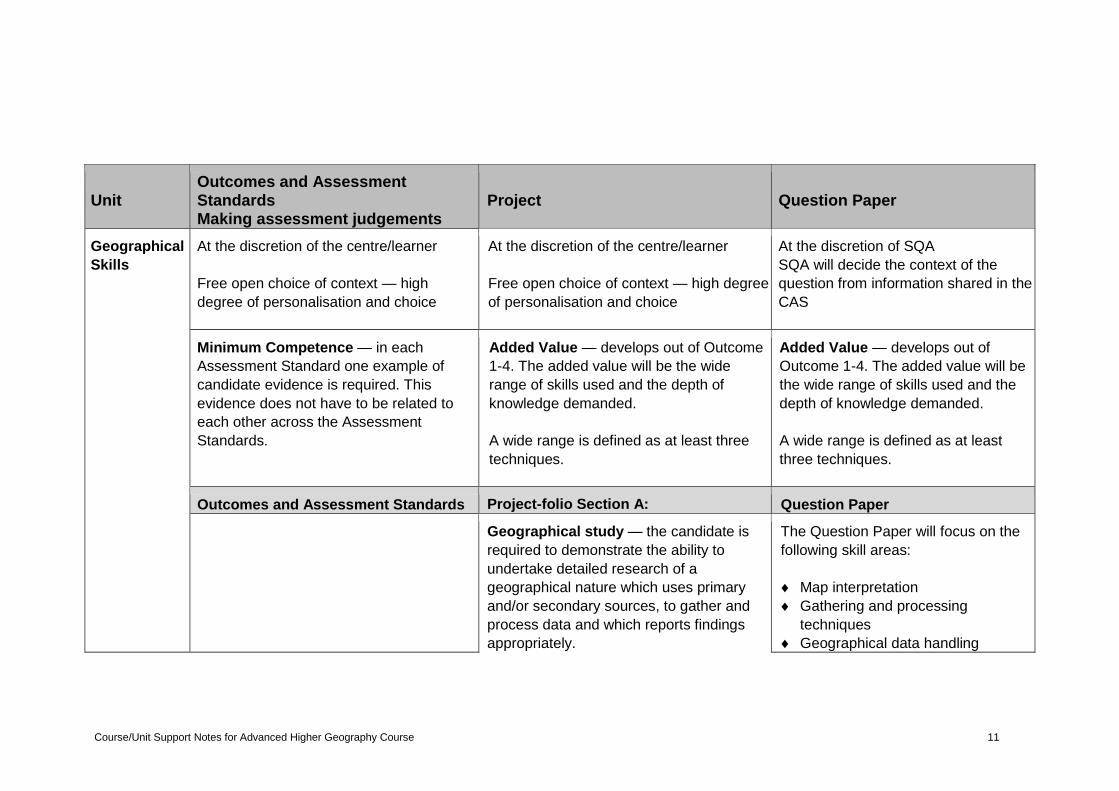
Unit Outcomes and Assessment Standards Making assessment judgements
Project Question Paper
Geographical
Skills
At the discretion of the centre/learner
Free open choice of context — high
degree of personalisation and choice
At the discretion of the centre/learner
Free open choice of context — high degree
of personalisation and choice
At the discretion of SQA
SQA will decide the context of the
question from information shared in the
CAS
Minimum Competence — in each
Assessment Standard one example of
candidate evidence is required. This
evidence does not have to be related to
each other across the Assessment
Standards.
Added Value — develops out of Outcome
1-4. The added value will be the wide
range of skills used and the depth of
knowledge demanded.
A wide range is defined as at least three
techniques.
Added Value — develops out of
Outcome 1-4. The added value will be
the wide range of skills used and the
depth of knowledge demanded.
A wide range is defined as at least
three techniques.
Outcomes and Assessment Standards Project-folio Section A: Question Paper
Geographical study — the candidate is
required to demonstrate the ability to
undertake detailed research of a
geographical nature which uses primary
and/or secondary sources, to gather and
process data and which reports findings
appropriately.
The Question Paper will focus on the
following skill areas:
Map interpretation
Gathering and processing
techniques
Geographical data handling
Course/Unit Support Notes for Advanced Higher Geography Course 12
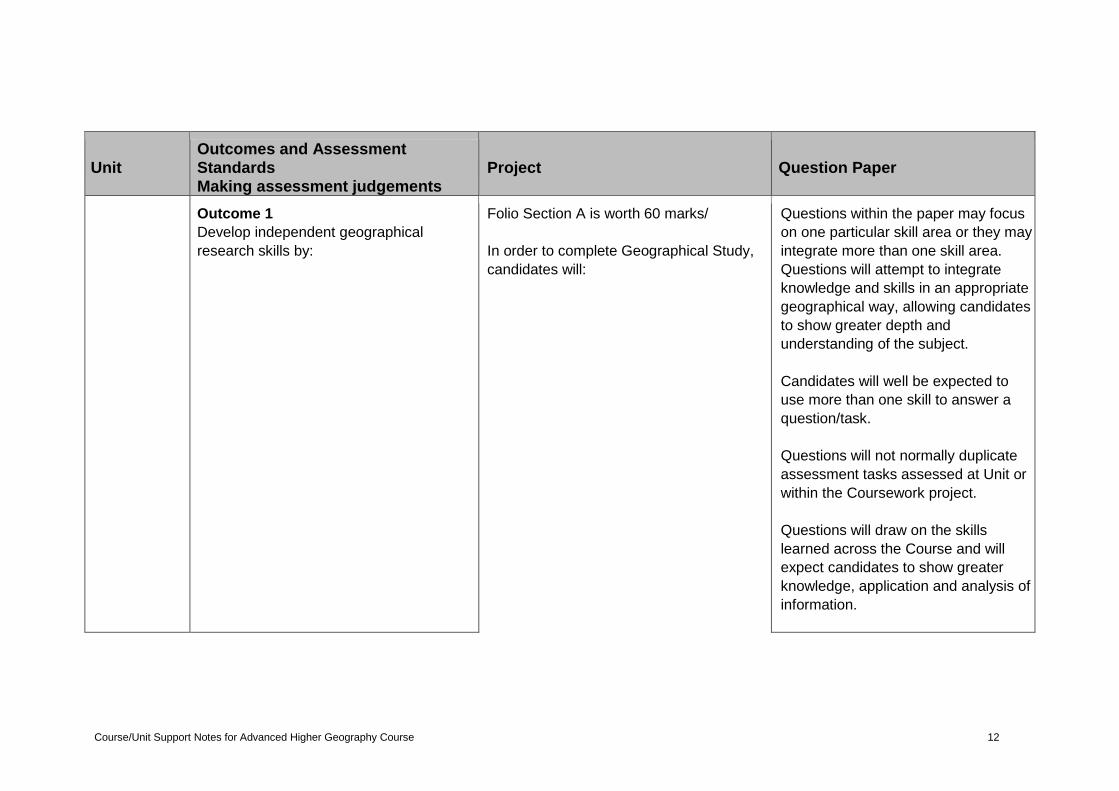
Unit Outcomes and Assessment Standards Making assessment judgements
Project Question Paper
Outcome 1
Develop independent geographical
research skills by:
Folio Section A is worth 60 marks/
In order to complete Geographical Study,
candidates will:
Questions within the paper may focus
on one particular skill area or they may
integrate more than one skill area.
Questions will attempt to integrate
knowledge and skills in an appropriate
geographical way, allowing candidates
to show greater depth and
understanding of the subject.
Candidates will well be expected to
use more than one skill to answer a
question/task.
Questions will not normally duplicate
assessment tasks assessed at Unit or
within the Coursework project.
Questions will draw on the skills
learned across the Course and will
expect candidates to show greater
knowledge, application and analysis of
information.
Course/Unit Support Notes for Advanced Higher Geography Course 13
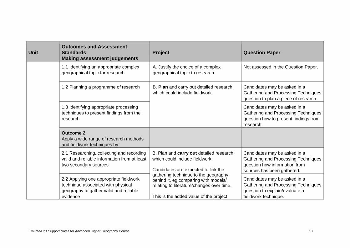
Unit Outcomes and Assessment Standards Making assessment judgements
Project Question Paper
1.1 Identifying an appropriate complex
geographical topic for research
A. Justify the choice of a complex
geographical topic to research
Not assessed in the Question Paper.
1.2 Planning a programme of research B. Plan and carry out detailed research,
which could include fieldwork
Candidates may be asked in a
Gathering and Processing Techniques
question to plan a piece of research.
1.3 Identifying appropriate processing
techniques to present findings from the
research
Candidates may be asked in a
Gathering and Processing Techniques
question how to present findings from
research.
Outcome 2
Apply a wide range of research methods
and fieldwork techniques by:
2.1 Researching, collecting and recording
valid and reliable information from at least
two secondary sources
B. Plan and carry out detailed research,
which could include fieldwork.
Candidates are expected to link the gathering technique to the geography behind it, eg comparing with models/ relating to literature/changes over time.
This is the added value of the project
Candidates may be asked in a
Gathering and Processing Techniques
question how information from
sources has been gathered.
2.2 Applying one appropriate fieldwork
technique associated with physical
geography to gather valid and reliable
evidence
Candidates may be asked in a
Gathering and Processing Techniques
question to explain/evaluate a
fieldwork technique.
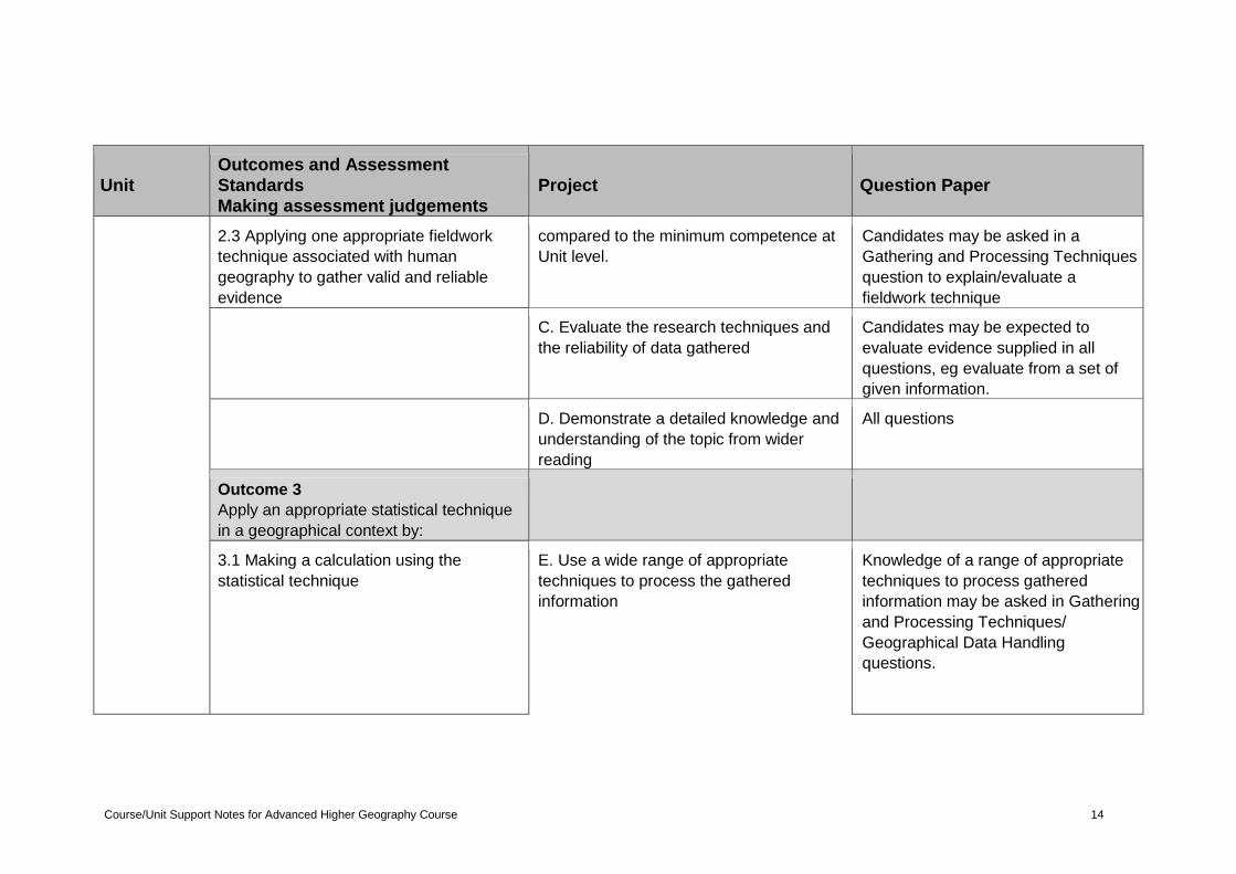
Course/Unit Support Notes for Advanced Higher Geography Course 14
Unit Outcomes and Assessment Standards Making assessment judgements
Project Question Paper
2.3 Applying one appropriate fieldwork
technique associated with human
geography to gather valid and reliable
evidence
compared to the minimum competence at
Unit level.
Candidates may be asked in a
Gathering and Processing Techniques
question to explain/evaluate a
fieldwork technique
C. Evaluate the research techniques and
the reliability of data gathered
Candidates may be expected to
evaluate evidence supplied in all
questions, eg evaluate from a set of
given information.
D. Demonstrate a detailed knowledge and
understanding of the topic from wider
reading
All questions
Outcome 3
Apply an appropriate statistical technique
in a geographical context by:
3.1 Making a calculation using the
statistical technique
E. Use a wide range of appropriate
techniques to process the gathered
information
Knowledge of a range of appropriate
techniques to process gathered
information may be asked in Gathering
and Processing Techniques/
Geographical Data Handling
questions.
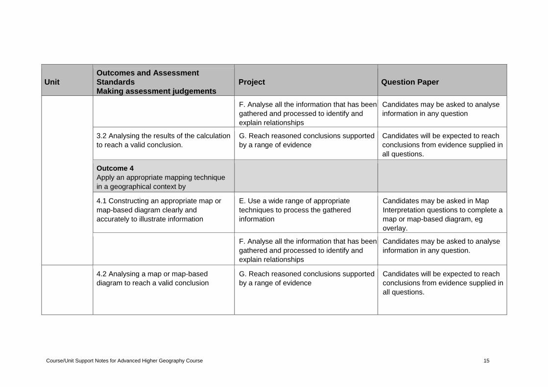
Course/Unit Support Notes for Advanced Higher Geography Course 15
Unit Outcomes and Assessment Standards Making assessment judgements
Project Question Paper
F. Analyse all the information that has been
gathered and processed to identify and
explain relationships
Candidates may be asked to analyse
information in any question
3.2 Analysing the results of the calculation
to reach a valid conclusion.
G. Reach reasoned conclusions supported
by a range of evidence
Candidates will be expected to reach
conclusions from evidence supplied in
all questions.
Outcome 4
Apply an appropriate mapping technique
in a geographical context by
4.1 Constructing an appropriate map or
map-based diagram clearly and
accurately to illustrate information
E. Use a wide range of appropriate
techniques to process the gathered
information
Candidates may be asked in Map
Interpretation questions to complete a
map or map-based diagram, eg
overlay.
F. Analyse all the information that has been
gathered and processed to identify and
explain relationships
Candidates may be asked to analyse
information in any question.
4.2 Analysing a map or map-based
diagram to reach a valid conclusion
G. Reach reasoned conclusions supported
by a range of evidence
Candidates will be expected to reach
conclusions from evidence supplied in
all questions.
Course/Unit Support Notes for Advanced Higher Geography Course 16
Unit Outcomes and Assessment Standards Making assessment judgements
Project Question Paper
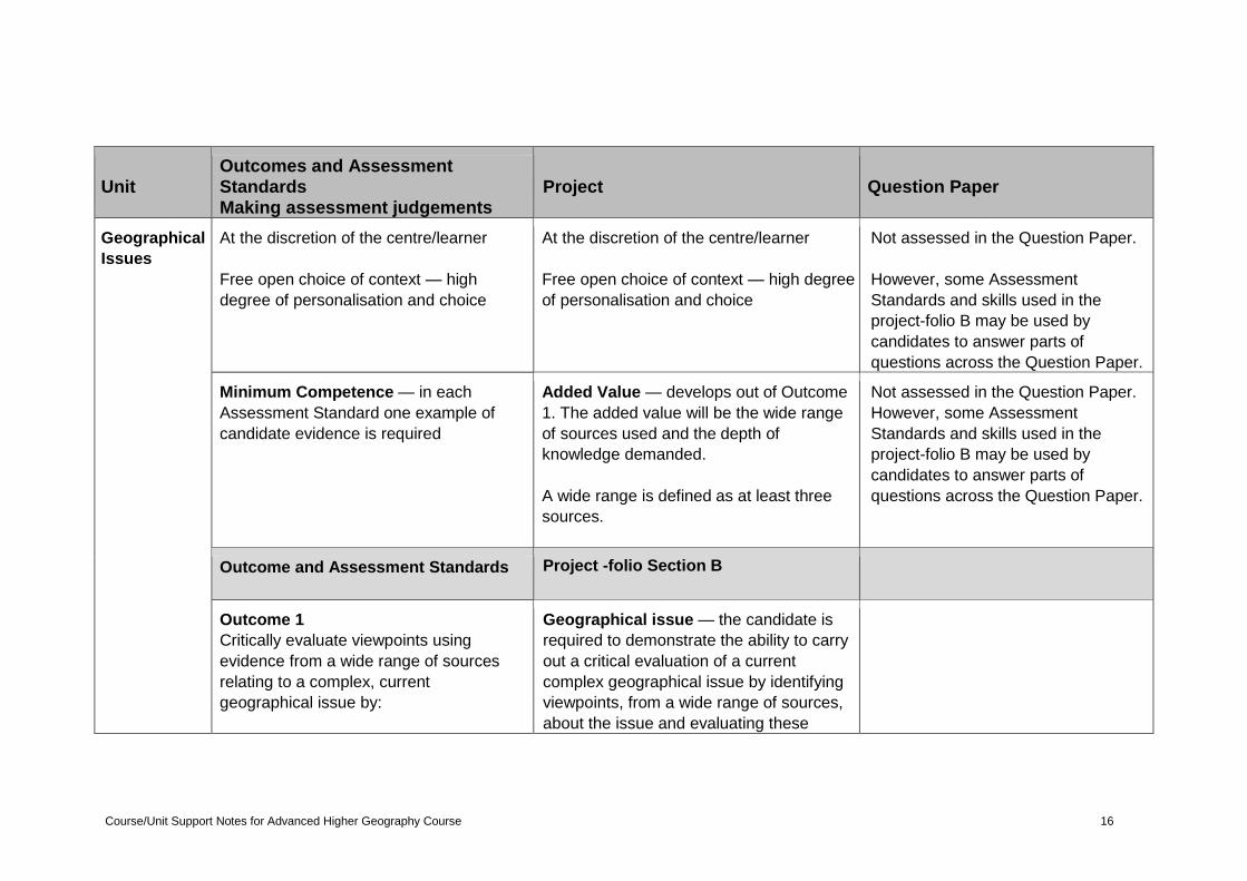
Geographical
Issues
At the discretion of the centre/learner
Free open choice of context — high
degree of personalisation and choice
At the discretion of the centre/learner
Free open choice of context — high degree
of personalisation and choice
Not assessed in the Question Paper.
However, some Assessment
Standards and skills used in the
project-folio B may be used by
candidates to answer parts of
questions across the Question Paper.
Minimum Competence — in each
Assessment Standard one example of
candidate evidence is required
Added Value — develops out of Outcome
1. The added value will be the wide range
of sources used and the depth of
knowledge demanded.
A wide range is defined as at least three
sources.
Not assessed in the Question Paper.
However, some Assessment
Standards and skills used in the
project-folio B may be used by
candidates to answer parts of
questions across the Question Paper.
Outcome and Assessment Standards Project -folio Section B
Outcome 1
Critically evaluate viewpoints using
evidence from a wide range of sources
relating to a complex, current
geographical issue by:
Geographical issue — the candidate is
required to demonstrate the ability to carry
out a critical evaluation of a current
complex geographical issue by identifying
viewpoints, from a wide range of sources,
about the issue and evaluating these
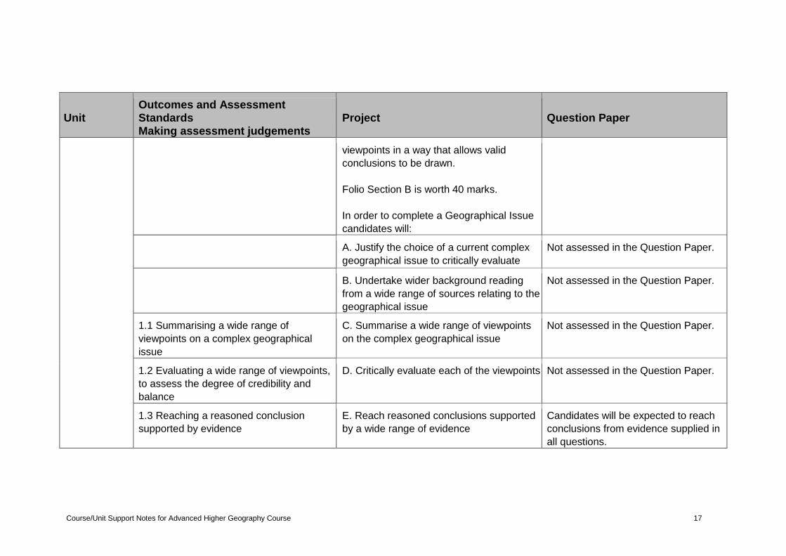
Course/Unit Support Notes for Advanced Higher Geography Course 17
Unit Outcomes and Assessment Standards Making assessment judgements
Project Question Paper
viewpoints in a way that allows valid
conclusions to be drawn.
Folio Section B is worth 40 marks.
In order to complete a Geographical Issue
candidates will:
A. Justify the choice of a current complex
geographical issue to critically evaluate
Not assessed in the Question Paper.
B. Undertake wider background reading
from a wide range of sources relating to the
geographical issue
Not assessed in the Question Paper.
1.1 Summarising a wide range of
viewpoints on a complex geographical
issue
C. Summarise a wide range of viewpoints
on the complex geographical issue
Not assessed in the Question Paper.
1.2 Evaluating a wide range of viewpoints,
to assess the degree of credibility and
balance
D. Critically evaluate each of the viewpoints Not assessed in the Question Paper.
1.3 Reaching a reasoned conclusion
supported by evidence
E. Reach reasoned conclusions supported
by a wide range of evidence
Candidates will be expected to reach
conclusions from evidence supplied in
all questions.
Course/Unit Support Notes for Advanced Higher Geography Course 18
Course Units
Geographical Skills Unit
The general aim of this Unit is to allow candidates to further develop their range
of geographical methods and techniques. These include mapping skills, graphical
techniques and a range of statistical techniques for gathering, analysing and
interpreting geographical data. Learners will also develop a range of independent
geographical research skills.
To achieve this they will:
develop independent geographical research skills
apply a wide range of research methods and fieldwork techniques
apply an appropriate statistical technique in a geographical context
apply an appropriate mapping technique in a geographical context
Developing independent geographical research skills
At Unit level candidates may need support and guidance in planning their choice
of topic. This will include a degree of background reading to support their choice
of topic and should be supported by appropriate learning and teaching
experiences.
Candidates should identify a topic that has a sufficient level of demand to
allow scope for:
wide-ranging research
gathering and using both primary and secondary sources
detailed analysis of data
detailed processing of data
Candidates should produce a plan which must include an appropriate:
location to carry out the research
research methodology
suitable fieldwork technique(s) for the chosen topic
timing for the research
In their plan candidates should identify appropriate but different processing
techniques which could be used to present findings from their research.
Research/fieldwork
The candidate’s choice of topic may use either:
primary fieldwork sources
or
secondary sources
or
a combination of both
Group fieldwork data is perfectly acceptable. An example of this might be data
collected as part of a river study. This may well be better for safe working and a
Course/Unit Support Notes for Advanced Higher Geography Course 19
larger set of data can be collected. However, the group nature of the data must
be acknowledged by candidates in their response.
At Unit level, fieldwork is an integral part of the learning and teaching. It provides
candidates with the opportunity to apply appropriate fieldwork techniques in both
a physical and human context. It also gives the candidate an opportunity to
demonstrate skills in this area of the Advanced Higher curriculum. The timing of
fieldwork is important. If not timed appropriately, candidates may not leave
enough time to complete the Unit assessment. This should be discussed with the
candidates to help them understand why time scheduling is so critical. The use of
a fieldwork notebook is good practice.
Consideration should be given at all times to candidates’ safety when carrying
out any fieldwork.
Physical gathering techniques
Candidates should provide evidence of how a fieldwork technique associated
with physical geography is used.
To do this they must provide:
identification of a physical fieldwork technique
detailed explanation of the sampling technique used, to allow for the
collection of valid and reliable data
detailed description of how the data was collected to provide relevant
evidence
a record of the data collected (which might include annotated photographs/
diagrams/sketches where appropriate)
Candidates should be encouraged to use appropriate websites and text books on
how to apply physical techniques.
Possible physical techniques that could be used might include:
Beach profile analysis
This technique involves measurement of the changes in the gradient of a beach
from sea level to the shore top. This may involve recognising the significant
features of the beach and develop an understanding of how it may change over
time.
Micro-climate analysis
This technique is used to measure:
wind speed and direction — anemometer and weather vane respectively (use
a compass and Beaufort scale if these are unavailable)
temperature, relative humidity and light level — use a thermometer,
hygrometer and light meter
precipitation — rain gauge and recording sheet
Course/Unit Support Notes for Advanced Higher Geography Course 20
Pebble analysis
This technique is used to measure the size, shape and rock type of pebbles
within a prescribed area, for example:
pebble angularity — several samples taken across the width of a river and
compared to a pebble size table
pebble size — use calipers to measure the axis proportions
Slope analysis
This technique is carried out to investigate the variations in variables along a
slope transect, for example:
humus depth — soil profiles cut into slope transect and humus depths
recorded
acidity — pH measuring paper or a digital pH measurer
Soil analysis
These study techniques measure the properties of a soil sample.
pH — either an electronic meter can be used or the test-tube and indicator
solution method where a soil sample is mixed with barium sulphate, pure
water and pH indicator solution and compared to a pH chart
temperature and moisture — temperature and moisture probes can be used.
Alternatively, a soil sample can be taken in a sealed plastic bag and the
moisture content found by weighing, drying out in an oven and then re-
weighing
soil profile — a section is dug out of the soil so that the different horizons can
be seen. Written descriptions can be recorded of the structure, texture,
organic content, colour and depth of each horizon
Stream analysis
These techniques are appropriate to studying how the physical properties of a
river and its channel vary along its course, for example:
river depth — use a meter ruler or ranging pole and take measurements at
regular 30cm to 50cm intervals (depending on the channel size). Can be used
to build cross-section graphs.
river width — stretch a tape measure taut across the river at 90o to the
channel. The start and finish points of the tape will depend on whether you
are investigating the river at its existing level or in high spate. Measuring at
the vegetation line can show this variation.
wetted perimeter — wetted perimeter can be measured using a heavy chain,
rope or measure tape, which should be stretched across the river bed from
one bank to the other. Can be used to establish discharge levels from cross-
section area graphs.
flow rate — either use a flow meter or a floating object such as an orange to
record the time taken for the object to travel over a set distance. Speed
equals distance over time.
Course/Unit Support Notes for Advanced Higher Geography Course 21
Vegetation sampling
This technique is used to determine the amount and variety of vegetation in a
prescribed area, for example:
vegetation amount — a quadrat randomly thrown and number of species per
square recorded as a % total
vegetation type — a camera is useful, or plastic bags to store samples for
later identification
Human gathering techniques
Candidates should provide evidence of how a fieldwork technique associated
with human geography is used.
To do this they must provide:
identification of a human fieldwork technique
detailed explanation of the sampling technique used, to allow for the
collection of valid and reliable data
detailed description of how the data was collected, to provide relevant
evidence
a record of the data collected (which might include annotated photographs/
diagrams/sketches where appropriate)
Candidates should be encouraged to use appropriate websites and text books on
how to apply human techniques.
Possible human techniques that could be used might include:
Environmental quality survey
Use a decibel meter to measure noise levels (free apps are available). Use a
perception study to record levels of air quality. A camera can record levels of
graffiti, litter and vandalism.
Interview design and implementation
Interviews are more focused and flexible than questionnaires, where open-ended
(rather than closed) questions are more appropriate and the opportunity for
respondents to give their opinions without being pigeonholed by option boxes is
possible. Interviews can pursue more interesting points and can adapt to the
conversation.
Pedestrian survey
Use a recording sheet and ‘click’ counter to record pedestrian numbers at
selected sites. Site selection and time of day will be important considerations.
Perception studies
Use mental maps or perception surveys to examine and compare people's
perceptions of, for example, a suburban environment or the limits of their
neighbourhood, gathered largely through questionnaires and interviews.
Course/Unit Support Notes for Advanced Higher Geography Course 22
Questionnaire design and implementation
Questionnaires are where the opinions of a group or groups of people are
relevant. They can gather information about the people (eg a survey to
investigate the characteristics of a group), information about patterns and
processes (eg the sphere of influence of services for shoppers or commuters), or
information about opinions and behaviour.
Rural land use mapping
Use OS maps and land-use records to map land uses for use in choropleth
mapping. Interview farmers for details on changes in land use. Consult older
maps for evidence of change in the landscape.
Urban land use mapping
Use OS maps and land-use mapping keys (RICEPOTS) to record land use,
building height and quality. Use recording sheets to record environmental quality
surveys, interviews and questionnaires. Decibel metres (easily available as free
Apps) can be used to measure noise pollution.
Traffic survey
Traffic counts will require a timer. Record outbound and inbound traffic, time at
stand still and various vehicle types. Location choice and time of day will be
important considerations.
Course/Unit Support Notes for Advanced Higher Geography Course 23
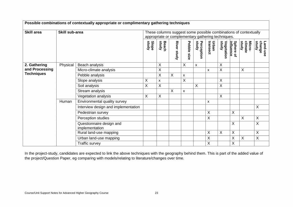
In the project-study, candidates are expected to link the above techniques with the geography behind them. This is part of the added value of
the project/Question Paper, eg comparing with models/relating to literature/changes over time.
Possible combinations of contextually appropriate or complimentary gathering techniques
Skill area Skill sub-area These columns suggest some possible combinations of contextually
appropriate or complementary gathering techniques.
Slo
pe
stu
dy
Beach
stu
dy
Riv
er s
tud
y
Peb
ble
siz
e
Perc
ep
tion
stu
dy
Urb
an
tra
nsect
Veg
eta
tion
stu
dy
Sp
here
of
influ
en
ce
Stu
dy
Mic
ro-
clim
ate
stu
dy
Lan
d-u
se
ch
an
ge
stu
dy
2. Gathering and Processing Techniques
Physical Beach analysis X X x X
Micro-climate analysis X x X X
Pebble analysis X X x
Slope analysis X x X X
Soil analysis X X X X
Stream analysis X x
Vegetation analysis X X X
Human Environmental quality survey x
Interview design and implementation X
Pedestrian survey X X
Perception studies X X X
Questionnaire design and implementation
X X
Rural land-use mapping X X X X
Urban land-use mapping X X X X
Traffic survey X X
Course/Unit Support Notes for Advanced Higher Geography Course 24
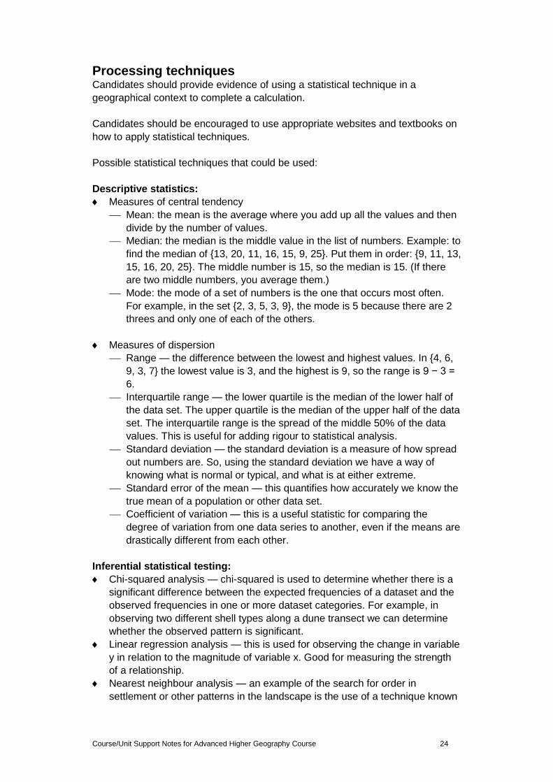
Processing techniques Candidates should provide evidence of using a statistical technique in a
geographical context to complete a calculation.
Candidates should be encouraged to use appropriate websites and textbooks on
how to apply statistical techniques.
Possible statistical techniques that could be used:
Descriptive statistics:
Measures of central tendency
Mean: the mean is the average where you add up all the values and then
divide by the number of values.
Median: the median is the middle value in the list of numbers. Example: to
find the median of {13, 20, 11, 16, 15, 9, 25}. Put them in order: {9, 11, 13,
15, 16, 20, 25}. The middle number is 15, so the median is 15. (If there
are two middle numbers, you average them.)
Mode: the mode of a set of numbers is the one that occurs most often.
For example, in the set {2, 3, 5, 3, 9}, the mode is 5 because there are 2
threes and only one of each of the others.
Measures of dispersion
Range — the difference between the lowest and highest values. In {4, 6,
9, 3, 7} the lowest value is 3, and the highest is 9, so the range is 9 − 3 =
6.
Interquartile range — the lower quartile is the median of the lower half of
the data set. The upper quartile is the median of the upper half of the data
set. The interquartile range is the spread of the middle 50% of the data
values. This is useful for adding rigour to statistical analysis.
Standard deviation — the standard deviation is a measure of how spread
out numbers are. So, using the standard deviation we have a way of
knowing what is normal or typical, and what is at either extreme.
Standard error of the mean — this quantifies how accurately we know the
true mean of a population or other data set.
Coefficient of variation — this is a useful statistic for comparing the
degree of variation from one data series to another, even if the means are
drastically different from each other.
Inferential statistical testing:
Chi-squared analysis — chi-squared is used to determine whether there is a
significant difference between the expected frequencies of a dataset and the
observed frequencies in one or more dataset categories. For example, in
observing two different shell types along a dune transect we can determine
whether the observed pattern is significant.
Linear regression analysis — this is used for observing the change in variable
y in relation to the magnitude of variable x. Good for measuring the strength
of a relationship.
Nearest neighbour analysis — an example of the search for order in
settlement or other patterns in the landscape is the use of a technique known
Course/Unit Support Notes for Advanced Higher Geography Course 25
as nearest neighbour analysis. This attempts to measure the distributions
according to whether they are clustered, random or regular.
Pearson’s product moment correlation coefficient — Pearson’s is another
method of finding the strength of a relationship but is more accurate than
Spearman’s.
Spearman’s rank correlation coefficient — Spearman’s rank is a simple and
effective way to find the strength of a relationship/correlation.
Mapping techniques
Candidates should provide evidence of using a map or map-based technique used in a geographical context.
Candidates should be encouraged to use appropriate websites and textbooks on
how to use map or map-based techniques.
Possible map or map-based techniques that could be used:
Annotated diagram/overlay — a comparative method of displaying information
such as changes in household income and house price.
Choropleth map — a choropleth map is one in which areas are shaded or
patterned in proportion to the measurement of the value being shown on the
map, eg population density or per-capita income.
Cross-sections — cross-section maps show a feature such as a meander, sand
dune or mountain in section as if sliced in two.
Dot map — a dot distribution map (sometimes referred to as a dot density map)
is as a map that uses a dots to show the presence of a feature or value. Dot
maps rely on a visual scatter to show spatial pattern.
Flow line map — flow maps show movement of objects or systems from one
location to another, eg migration numbers or inputs and export trade balances.
Isoline map — isoline maps show spatial distributions.
Proportional symbols map — proportional symbol maps use simple symbols
(usually a circle or square) and change their proportions relative to the data
value found at that location.
Sphere of influence map — a sphere of influence map shows the area of
influence of a factor such as number of tourist visits or distance commuted
relative to a reference point on the map.
Transects — a straight line drawn across a photo or map against which values,
distributions, patterns, observations and measurements can be shown.
Course/Unit Support Notes for Advanced Higher Geography Course 26
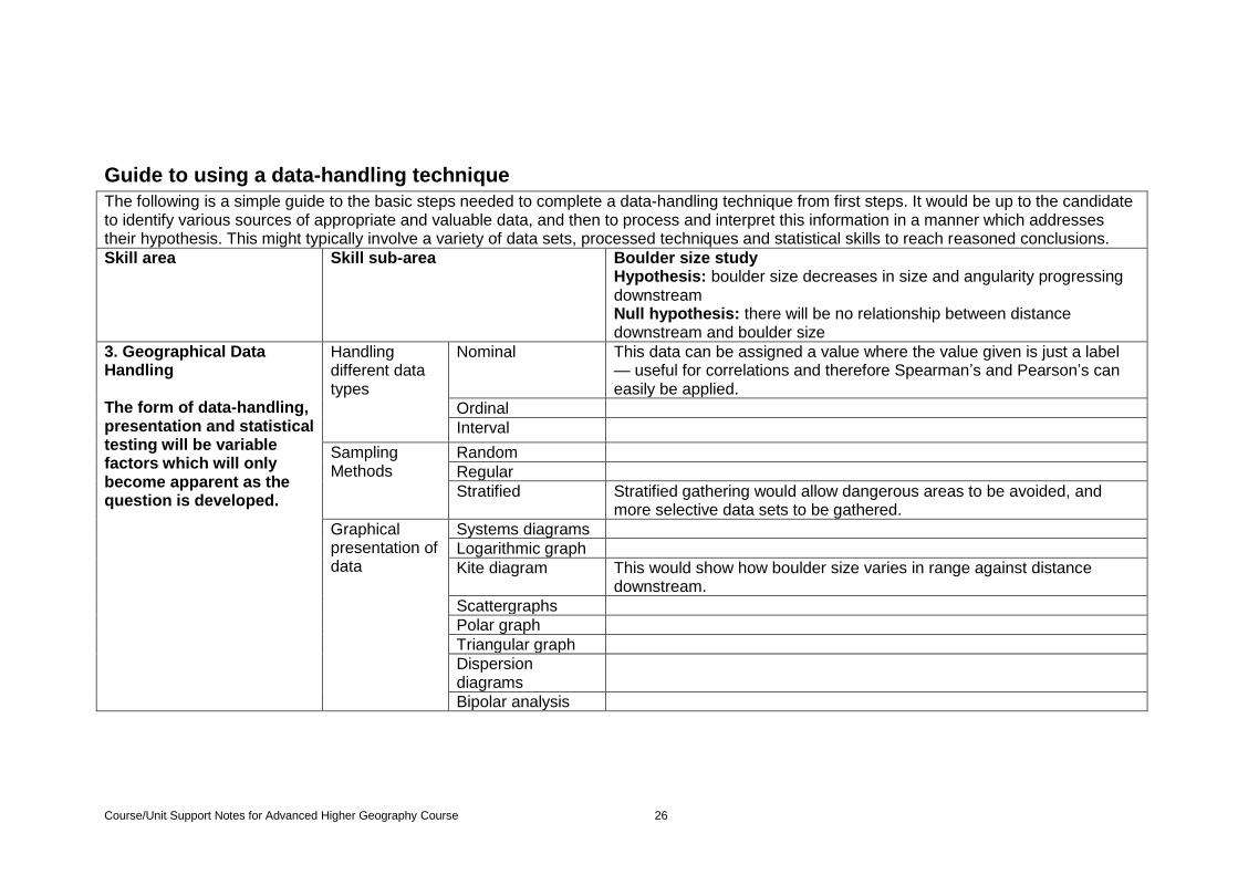
Guide to using a data-handling technique
The following is a simple guide to the basic steps needed to complete a data-handling technique from first steps. It would be up to the candidate to identify various sources of appropriate and valuable data, and then to process and interpret this information in a manner which addresses their hypothesis. This might typically involve a variety of data sets, processed techniques and statistical skills to reach reasoned conclusions.
1. Skill area Skill sub-area Boulder size study Hypothesis: boulder size decreases in size and angularity progressing downstream Null hypothesis: there will be no relationship between distance downstream and boulder size
2. 3. Geographical Data Handling The form of data-handling, presentation and statistical testing will be variable factors which will only become apparent as the question is developed.
Handling different data types
Nominal This data can be assigned a value where the value given is just a label — useful for correlations and therefore Spearman’s and Pearson’s can easily be applied.
Ordinal
Interval
Sampling Methods
Random
Regular
Stratified Stratified gathering would allow dangerous areas to be avoided, and more selective data sets to be gathered.
Graphical presentation of data
Systems diagrams
Logarithmic graph
Kite diagram This would show how boulder size varies in range against distance downstream.
Scattergraphs
Polar graph
Triangular graph
Dispersion diagrams
Bipolar analysis
Course/Unit Support Notes for Advanced Higher Geography Course 27
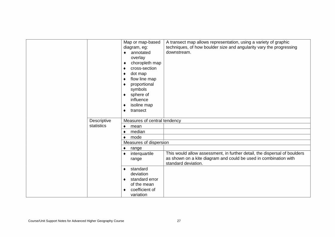
Map or map-based diagram, eg:
annotated overlay
choropleth map
cross-section
dot map
flow line map
proportional symbols
sphere of influence
isoline map
transect
A transect map allows representation, using a variety of graphic techniques, of how boulder size and angularity vary the progressing downstream.
Descriptive statistics
Measures of central tendency
mean
median
mode
Measures of dispersion
range
interquartile range
This would allow assessment, in further detail, the dispersal of boulders as shown on a kite diagram and could be used in combination with standard deviation.
standard deviation
standard error of the mean
coefficient of variation
Course/Unit Support Notes for Advanced Higher Geography Course 28
Inferential statistical testing
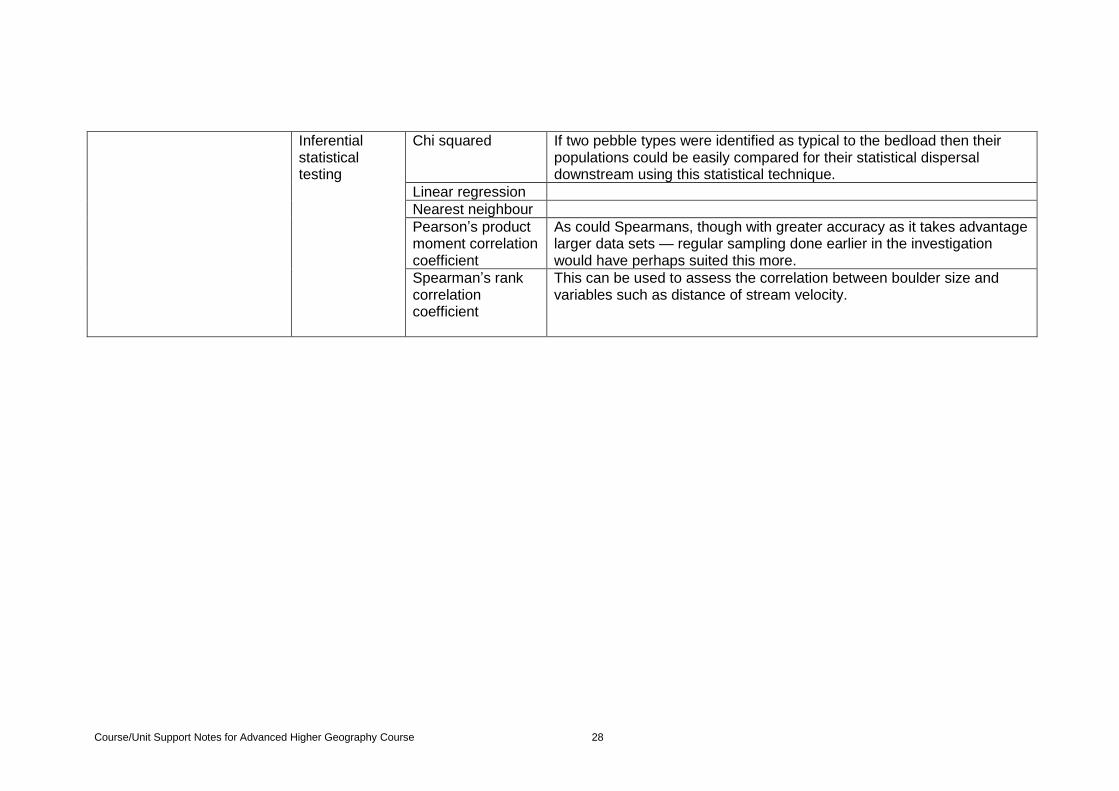
Chi squared If two pebble types were identified as typical to the bedload then their populations could be easily compared for their statistical dispersal downstream using this statistical technique.
Linear regression
Nearest neighbour
Pearson’s product moment correlation coefficient
As could Spearmans, though with greater accuracy as it takes advantage larger data sets — regular sampling done earlier in the investigation would have perhaps suited this more.
Spearman’s rank correlation coefficient
This can be used to assess the correlation between boulder size and variables such as distance of stream velocity.
Course/Unit Support Notes for Advanced Higher Geography Course 29
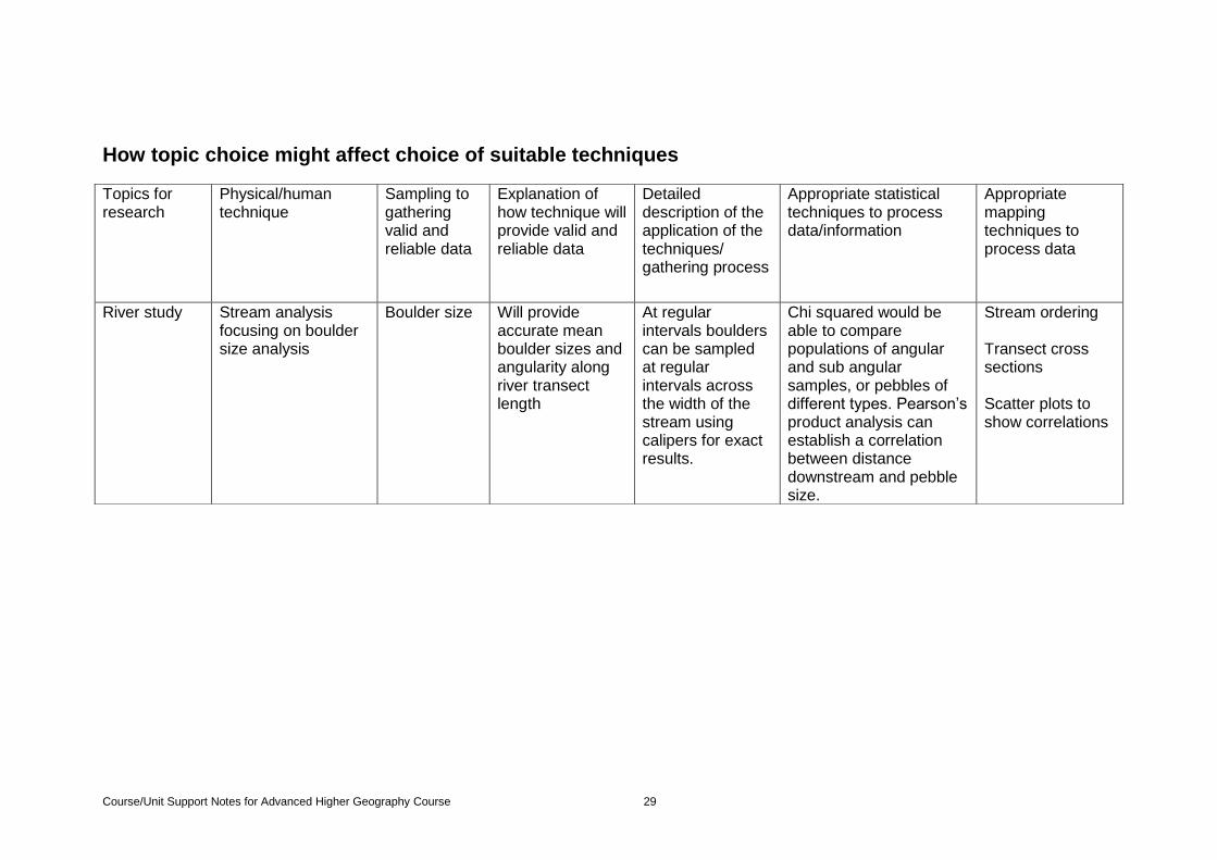
How topic choice might affect choice of suitable techniques
Topics for research
Physical/human technique
Sampling to gathering valid and reliable data
Explanation of how technique will provide valid and reliable data
Detailed description of the application of the techniques/ gathering process
Appropriate statistical techniques to process data/information
Appropriate mapping techniques to process data
River study Stream analysis focusing on boulder size analysis
Boulder size
Will provide accurate mean boulder sizes and angularity along river transect length
At regular intervals boulders can be sampled at regular intervals across the width of the stream using calipers for exact results.
Chi squared would be able to compare populations of angular and sub angular samples, or pebbles of different types. Pearson’s product analysis can establish a correlation between distance downstream and pebble size.
Stream ordering Transect cross sections Scatter plots to show correlations
Course/Unit Support Notes for Advanced Higher Geography Course 30
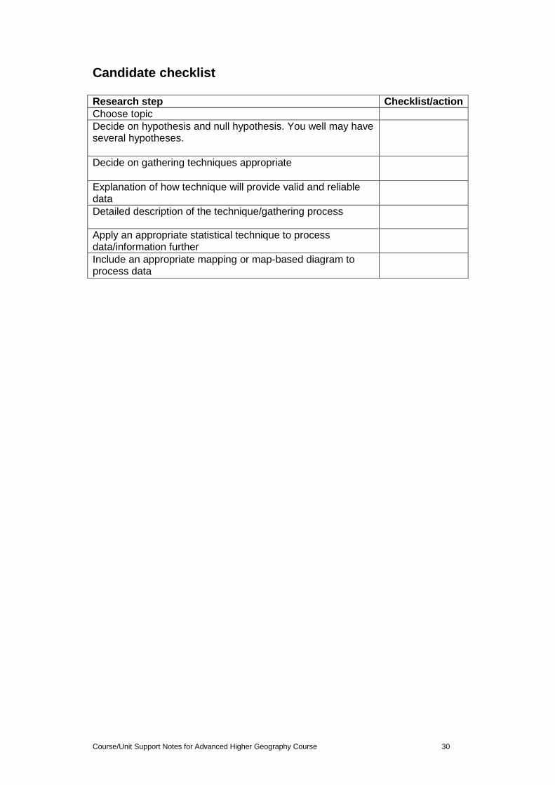
Candidate checklist Research step Checklist/action
Choose topic
Decide on hypothesis and null hypothesis. You well may have several hypotheses.
Decide on gathering techniques appropriate
Explanation of how technique will provide valid and reliable data
Detailed description of the technique/gathering process
Apply an appropriate statistical technique to process data/information further
Include an appropriate mapping or map-based diagram to process data
Course/Unit Support Notes for Advanced Higher Geography Course 31
Geographical Issues Unit
The general aim of this Unit is to develop critical thinking and the ability to
evaluate viewpoints using evidence from a wide range of sources on complex,
current geographical issues.
Learners who complete this Unit will critically evaluate viewpoints using evidence
from a wide range of sources relating to a complex, current geographical issue.
At Unit level, candidates will need support and guidance in summarising,
evaluating and reaching a conclusion. This may include a degree of background
reading to support their work and should be supported by appropriate learning
and teaching experiences.
Suitable issues to critically evaluate
The critical evaluation is based on viewpoints expressed in the sources and
requires candidates to reach a conclusion. It is therefore practical to base the
issue on a question or opinion.
At Unit level, candidates are provided with a topic to evaluate and relevant
and appropriate sources.
At Unit level, candidates are not required to identify a topic or select sources.
Centres should note that there is no requirement to base the issue on any
particular content, although it should have a clear geographical link, be
current and of a suitably complex nature.
Issues of a local nature are also useful as candidates may have a knowledge
of the issue but candidates should take care not to be influenced by personal
opinion as this will distract from the critical nature of the evaluation
Suitable sources for critical evaluation
There is no specified length required for a source; however centres should be
careful not to select sources that are overly complex or lengthy. It is also
important to consider that information could be interpreted from different sources
including visual, graphical and numerical. While the audience for which the
sources are intended is important in relation to the evaluation of the source, it
should be of a suitably complex nature.
It is important to check the department, school and local library for relevant
journals, reference magazines and newspaper articles which could provide
sources or background reading. While the source should be up-to-date, the exact
length duration of this will depend on the issue being investigated and may be
something which should allow comments on the critical evaluation rather than
being dismissed. Journals would normally be peer reviewed but
centres/candidates should not be under pressure to subscribe to or buy articles
to fit with an issue. Expert is also a term which would allow for comments in the
evaluation and is not one which relies solely on academic qualifications.
A large amount of suitably complex information and of reasonable length can be
located though the Open University website below.
http://www.open.edu/openlearn/
Course/Unit Support Notes for Advanced Higher Geography Course 32
How to summarise sources
At Unit level the candidate response must include summaries of the main
viewpoints from at least three sources.
Sources should:
be relevant to the topic
contain sufficient detail and be of sufficient length to allow for summary
give a range of viewpoints
The viewpoints could come to the same conclusion but the arguments may be
based on very different criteria. These need not be for or against but should have
sufficient controversy to allow evaluation and for a conclusion to be reached.
Summaries for each viewpoint should be approximately 100 words in length. This
word count is for illustrative purposes only and does not indicate a specified word
count.
In summarising, candidates should ensure that their summaries are:
staying relevant to the topic
covering the three viewpoints
of sufficient detail and length to show a good understanding of the individual
viewpoints
approximately 100 words in length (this word count is for illustrative purposes
only and does not indicate a specified word count)
How to evaluate sources
In evaluating each of the viewpoints on the issue, Candidates should ensure their
response refers to
the degree of balance within the source
the credibility of the content within the source
the degree of credibility of the author or the publisher
Reaching a conclusion on the issue
In reaching a conclusion on the issue candidates:
should use relevant evidence from all three sources
may identify arguments
for the issue
against the issue
or a selection of responses from the ‘for’ and ‘against’ positions
The conclusion need not be original, nor need it represent the candidate’s
own personal view.
Course/Unit Support Notes for Advanced Higher Geography Course 33
Project-folio Researching a topic for the study and/or issue for Advanced Higher Geography Coursework: A candidate guide The general aim of this section is to help you further develop a wide range of
your independent research skills.
It will allow you to develop your independent research skills by providing
guidance in:
identifying an appropriate, complex topic for the study and/or issue to
research
planning a programme of research
researching, collecting and recording information
evaluating, synthesising, and analysing information or evidence
understanding approaches to organising, presenting and referencing findings
in an appropriate geographical style
The following guidance relates to each of these skills and processes. You should
note that this advice is intended as general guidance only, and that you should
also refer to the Advanced Higher Geography documents for specific subject
information to support your area of research:
Course Specification
Course Assessment Specification
Unit Specification
1. Identifying an appropriate complex topic and/or for research
A complex study and/or issue requires you to analyse data or information and
make judgements, rather than undertake a simply descriptive or approach to a
topic/ issue. The topic or issue identified might be worded as a question,
statement, or a description of the area of study, and should be complex enough
that the you challenge yourself to provide a convincing overall conclusion(s) to
the questions raised in your area of research
An appropriate complex topic/issue is also one which will enable you to
investigate different perspectives, opinions or points of view. For some topics this
may mean significant differences of opinion — including major differences in the
interpretation of data, issues, events or developments.
It is likely that a complex topic and/or issue will give rise to a number of additional
questions, or related issues, which will need to be considered in order to reach
an overall conclusion. These might develop as you read more widely about your
chosen topic or issue. Also, providing good synthesis of research materials and
well developed analysis of information to reach an appropriate judgement(s) is an
important feature of a well-developed piece of research

Course/Unit Support Notes for Advanced Higher Geography Course 34
You might approach topics and/or issues which involve evaluation, analysis and
synthesis by posing one or more of the following questions, although these
approaches are not the only ways to do this, and this is not an exhaustive list
What is the current relevance/importance of the study/issue…?
What data/information do I need to collect..?
How important is some data/information…?
To what extent does …?
How far does/should…?
How justified is this view…?
How important a part…?
Which (pieces of information) better explain…?
Evidence of how you approached Identifying an appropriate, complex study
and/or issue for research can be generated in a variety of ways, such as a
checklist, indicating the chosen issue and describing the process of choosing it.
A short explanation could be produced to justify the issue selected.
2. Planning a programme of research
Once the topic and/or issue has been agreed with your teacher or lecturer, you
should begin planning a programme of research. This could include a variety of
steps, such as:
developing wider knowledge of any content, context or information, through
wider background reading or web-based information, relevant your chosen
topic and/or issue
coming to decisions about the way(s) in which your chosen topic and/or issue
will be researched
identifying a suitable range of resources for your topic and/or issue
planning timescales for each part of your researching process
agreeing key deadline dates for the completion of the different stages
involved in researching the topic and/or issue
Developing further knowledge of contexts relevant to the chosen topic
and/or issue
This will involve wider background reading, for example a textbook, online
resources, newspaper articles, chapters or articles from journals or other similar
sources. Your teachers or lecturers can help you identify suitable background
reading at this early stage, as well as helping you plan a timescale for completion
of your research
Making decisions about the way in which the chosen topic and/or issue will
be researched
You should take care to ensure that a sensible range of data/information/factors/
views/outcomes is considered, and that concentration on a narrow set of
data/information/factors/views/outcomes does not exclude consideration of
alternative data or information.
Course/Unit Support Notes for Advanced Higher Geography Course 35
You may find it helpful to construct a mind-map or other diagram of possible
questions/issues at this stage. Alternatively, you could discuss the chosen study
and /or issue with class colleagues or by a brainstorming session during which
they might contribute possible alternative approaches/interpretations or ideas.
These approaches can prove a useful tool in suggesting how questions/issues
relate to each other and to the overall chosen topic and/or issue.
To ensure that the approach taken is sufficiently in-depth, it may be useful to plan
how many questions/issues or headings are in your final plan. Your teachers or
lecturers can give advice about which information to include or reject, and help
with your critical thinking skills and discuss with you why you are using or
rejecting particular points or information.
Good planning is essential to researching your chosen study and/or issue as it
provides a structure for collecting information. However, remember that once you
start your research, changes to your plan may be necessary, for example if new
evidence or information emerges, or you wish to change the focus of your
research. This should be seen as an important part of planning a programme of
research, and you should recognise that this need to amend elements of any
original plan is a valid aspect of almost all independent research.
Sources of information often refer to the views/evidence cited or referred to by
other sources or authors. Noting references to these may help you understand
more about different interpretations of information, and help you in developing a
good analysis and conclusion at a later stage.
Checks on progress could take the form of a discussion between yourself and
your teacher/lecturer; or individual presentation to the group. In any discussion of
progress made, it may be helpful for you and your teacher/lecturer to make sure
that you are using evidence analytically and that a good structure to the is
emerging.
Possible ways of generating evidence
Evidence of how you approached your planning can be generated in a variety of
ways, such as a copy of your notes could be retained as evidence of researching,
collecting and recording information. Recording a detailed list of sources you
consulted may also help provide evidence for this stage of the process.
3. Researching, collecting and recording information
You might find it helpful to focus research on one aspect of your chosen topic
and/or issue at a time, rather than attempting to research, collect and record
information relating to the whole topic and/or issue at the same time.
For example, where the chosen topic and/or issue involves reference to a
particular data set or a range of factors, you may choose to start with research
focused on this aspect of the topic and/or issue. Researching one aspect at a
time can help to break the task up into more manageable sections and helps you
to review your progress. A progress record sheet as part of your log or record
keeping could be used to help you support this process.
Course/Unit Support Notes for Advanced Higher Geography Course 36
Once a starting point has been identified, you should decide how best to record
information gathered. Word-processed or hand written note-making will be the
most straightforward way of proceeding. Although you will have had some
previous experience of collecting and recording information, it is worth
emphasising that it is good practice to:
use the list of contents/index in any textbooks to identify sections relevant to
the topic and/or issue being studied
carry out initial reading or web-based research, to identify the most important
and relevant material(s)
be aware that many writers (particularly in academic journals) summarise
their arguments at the end of a section or chapter — alternatively, their views
may be outlined in the introduction or in the conclusion to the book or article
many of these writers cross reference their work to other writers, and you
should be careful to note this
You could complete a simple task like the one provided below to become familiar
with different sources of information and how sources are recorded or listed
(bibliographies). Your teachers or lecturers might have a short guide about
conducting research and observing ethical standards in research to help you
understand the importance of acknowledging sources and/or using sensitive
information.
There is no single approved way of collecting and recording information but the
following advice may prove useful:
Always note the author and title of the book/article being consulted. If it’s a
published work, the date of publication should also be recorded.
If the information is from an online or web based source, note the URL and
the date when accessed.
Summarise relevant factual evidence briefly, noting page references. By
summarising, rather than quoting directly, you will both save yourself time and
avoid unintended plagiarism. Similarly, there is no need to write in sentences
and abbreviations can speed up the note-making process.
Record statements of the author’s views by using phrases such as:
‘ According to Singer, 2012 “…”.’
The recording of brief direct quotations may be helpful but these should be
limited to a few words or phrases. Lengthy quotations are unhelpful. Page
references or noting the location of online or web based for views/quotations
should be noted to help your referencing at a later stage.
Writers for academic sources often refer to the views/evidence cited by other
academics sources. Noting references to these may help you understand
more about different academic/scientific interpretations, and help you develop
a convincing explanation or analysis at a later stage in your research.
Checks on your progress could take the form of a discussion between you
and your teacher/lecturer; or an individual presentation to your class group. In
any discussion of progress made, it may be helpful for your teacher/lecturer
to make sure that you are is using evidence appropriately and that a
convincing explanations and analyses is emerging from your research
Course/Unit Support Notes for Advanced Higher Geography Course 37
Possible ways of generating evidence
Evidence of how you approached researching, collecting and recording
information can be generated in a variety of ways, such as noting how you used
background reading, online or web based sources. This is a potential way to
develop your skills of critical analysis, evaluation and synthesis. Keeping a
literature review table or record can help you group together resources which
address the same topic and or issue. The issues and themes emerging from the
literature can be recorded and act as a framework for your research. An example
is provided at the end of this section.
4. Evaluating, analysing and synthesising evidence for a study and/or issue
Evaluation, analysis and synthesis will involve you in considering a range of
information to identify patterns, trends, exceptions and so on. Pictures, maps,
tables of statistics and written sources may all be relevant and you should look
closely at these to pick out what is relevant to your chosen topic and/or issue.
It is important that, having analysed the information and identified the relevance
of viewpoints presented in the sources, you make a critical evaluation of the
details you have collected. This will include you evaluating the validity of the
information presented and making a judgement on how you interpret the
viewpoint(s) in the sources.
When using and reviewing sources it may be helpful to take the following points
into account:
Identifying a suitable range of resources
As noted above, researching an appropriate topic and/or issue at Advanced
Higher should involve a wide range of academic and other reading and it is
therefore important that you plan ahead to ensure that the resources you
need are available when you need them. The starting point is likely to be
resources held within the geography department, but school and public
libraries may also be able to help you with access resources. Some university
libraries also provide reference facilities to final year school learners.
Sources might include online or web-based journals/papers, newspaper or
press articles or press releases and blogs.
For some topics/issues there are many published works and you may need
teacher/lecturer guidance to help you select appropriate reading. You may
also need help or advice to distinguish between school textbooks (or books
written for the general reader) and those written by academics with specialist
knowledge of the topic. A good range of academic work should be consulted
in your background reading and you should be able to recognise that different
approaches and perspectives on topics and/or issues may involve slightly
different interpretations of contexts or ideas and will require your careful
reading.
Researchers and authors use a wide variety of research methods to create
new information and you should be aware of some of these differences, for
example the differences between qualitative and quantitative data. . Research
methodology also shapes thinking, so you should try to ‘think like’ or ‘think
Course/Unit Support Notes for Advanced Higher Geography Course 38
within’ this particular piece of research. This will hopefully help you to become
a critical user of specific pieces of information
Possible ways of generating evidence
Evidence of evaluation, analysis and synthesis can be generated in a variety of
ways. You should try to keep a log or other record as you go through the process
of evaluation, analysis and synthesis. Evidence of this process will vary
depending on the topic and/or issue you have chosen and you may need some
teacher/lecturer guidance to help you decide on the best method(s) for this. You
should record sources you use in the process, including the author, page
references and publication date.
5. Understanding approaches to organising, presenting and referencing findings, in an appropriate geographical way/style
A critical skill is to understand how your findings should be presented in such a
way as to be clear, reliable and reflect a relevant geographical style. There is no
single way to achieve this and you should consider different possible approaches
to organising and referencing your work.
Organising
A key issue in communicating the ideas you have evaluated, synthesised and
analysed from your research is to be able to structure your findings appropriately.
This will normally involve laying out issues relevant to the question(s) posed in
your topic and/or issue in a logical manner which develops and leads to a
conclusion which can be supported by the evidence you have gathered.
This may mean going into detail on the various areas. These might well include:
matters of detail raised by the study and/or issue
alternative interpretations that have been produced by different viewpoints
detailed analysis of particular pieces of evidence/data/information that have a
substantial bearing on the study and/or issue
a wide-ranging consideration of all aspects of the study and/or issue
Presenting
The list below is one set of systems to present your topic and/or issue. You
should consult your teacher/lecturer for specific information about the specific
ways appropriate to the subject in question, and also any relevant information in
the following Advanced Higher Geography documents for specific subject
information on your area of research.
Course Specification
Course Assessment Specification and
Unit Specification
Please note that:
Writing should be presented on A4 single-sided pages.
A consistent referencing system should be used throughout.
Course/Unit Support Notes for Advanced Higher Geography Course 39
Main text should use a standard font.
Font size for the main text should be 12pt; titles/headings may be larger.
Line spacing should be 1.5.
Margins should be 2.5 cm on both LHS and RHS.
Text contained in diagrams may be smaller or larger but must be legible.
Direct quotes from the literature or primary sources can be indented, single-
spaced and with a small gap to separate from the main text.
Formatting should be consistent for the headings and subheading use; same
font, bold, italics.
Page numbers should be inserted at the foot of the page.
Layout of the project
Both parts of the project have defined word limits. The study should have no
more than 3,000 words and the issue should have no more than 1,800 words.
However, you might consider that a well-produced study would not normally
exceed 25 A4 pages and a well-produced issue would not normally exceed 12 A4
pages.
If a study and/or issue is judged to be of excessive word length, then the study
and/or issue will be referred to the Principal Assessor.
When considering the layout of your project you may want to consider, for
example:
Presenting text on A4 single-sided pages.
Larger page sizes can be used but will be judged against the equivalent A4
size, eg one A3 page is equal to two A4 pages
Using a standard font/size throughout, eg Arial 12pt (titles/headings may be
larger).
Using consistent line spacing, eg 1.5.
Using consistent formatting of headings and subheading, eg same font, bold,
italics.
Numbering each page
Making sure that text contained in diagrams is legible and relevant to the
diagram.
Presenting direct quotes from the literature or primary sources in such a way
that they are clearly separate from the main text.
References
You should understand how to use appropriate referencing system or
convention
You should be accurate in your references.
All your quotations should be referenced.
Specific facts such as statistics should usually be referenced unless they are
the commonly used in all books on the subject.
If a paragraph is based in its entirety on one book, then that should be
referenced, even if there is no direct quotation.
The style of referencing can be the straightforward one of:
Author, Date, Title, page number
Course/Unit Support Notes for Advanced Higher Geography Course 40
Example: Gillespie, R. (2011) Critical Navigation Skills, p93
Learners may use the conventional ibid and op cit as appropriate.
Research findings should be accompanied by a bibliography. As with references,
learning how to construct and present a proper bibliography is part of the process
of generating evidence of research for a topic and/or issue. The bibliography
should be a genuine note of all sources used. It is important that the author’s
name and the title are entered correctly. The date and publisher should also be
included (see above).
Most university websites have advice on setting out a bibliography. Some well-
known standard formats include Harvard, MLA and APA. The main point is that
you should be consistent in the format you choose to use and which is most
appropriate for your area of research.
Websites should also be recorded in the bibliography. Web addresses should be
listed, with the dates at which they were accessed. This is done because
websites are subject to frequent alteration.
Agreeing key deadline dates for the completion of the different stages
involved in researching the study and issue
You may find the process of researching independently a challenging task.
Therefore it may be helpful for your teacher/lecturer/yourself to agree dates at
which your progress can be reviewed.
Key dates might include:
selection of a topic and/or issue study and/or issue
completion of a plan for researching the study and/or issue
reviews/discussion of the collecting and recording evidence

Course/Unit Support Notes for Advanced Higher Geography Course 41
Question Paper The purpose of the Question Paper is to demonstrate application of skills and
breadth of knowledge and understanding from across the Course by sampling
from the mandatory information on Course coverage.
This Question Paper will give learners an opportunity to demonstrate the
following skills and knowledge and understanding:
knowledge of a wide range of geographical methods and techniques and
understanding of the contexts in which they ought to be used
application of a wide range of geographical methods and techniques including
mapping skills, research /fieldwork skills, graphical techniques and statistical
techniques for analysing and interpreting geographical data
The Question Paper will be marked out of 50.
The questions or sub-questions will cover the three skill areas of Map
Interpretation, Gathering and Processing Techniques, and Geographical
Data Handling, using relevant accompanying supplementary items.
Questions within the paper may focus on one particular skill area or they may
integrate more than one skill area.
Candidates will answer all questions.
Question Paper: Skill areas
Map interpretation: (20 marks) — the candidate will be expected to demonstrate
mapping skills techniques through their ability to use evidence from maps and
other supplementary items to support a response. 1:25000 scale Ordnance
Survey (OS) Explorer Series topographical sheets of England and Wales will be
used. Although assessing the skills of map interpretation, it is anticipated that
candidates will apply prior knowledge of map reading and interpretation to these
questions, eg use of scale, drawing to scale, interpretation of relief and surface
features, etc. This will also include grid references and reference to features
symbolised on the map.
In addition to the OS map, supplementary items will be provided in the form of
one or more of the following: maps or map-based diagrams, photographs,
sketches, graphical information or outline drawings or drawings based on
photographs, data tables and written text about the area.
Gathering and processing techniques: (10 marks) — the candidate will be
expected to demonstrate their knowledge and understanding of gathering and
processing techniques in the context of research/fieldwork, and the analysis/
evaluation of data which might be obtained as a result of using those techniques. Questions may use the supplementary items supplied with the Question Paper. (Candidates will not be asked to carry out calculations or complete tables of data
in the Question Paper. These are assessed at Unit level and in the project-folio.)
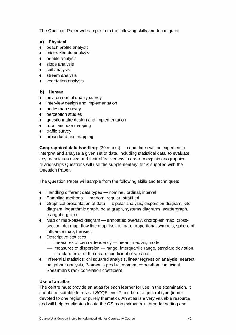
Course/Unit Support Notes for Advanced Higher Geography Course 42
The Question Paper will sample from the following skills and techniques:
a) Physical
beach profile analysis
micro-climate analysis
pebble analysis
slope analysis
soil analysis
stream analysis
vegetation analysis
b) Human
environmental quality survey
interview design and implementation
pedestrian survey
perception studies
questionnaire design and implementation
rural land use mapping
traffic survey
urban land use mapping
Geographical data handling: (20 marks) — candidates will be expected to
interpret and analyse a given set of data, including statistical data, to evaluate
any techniques used and their effectiveness in order to explain geographical
relationships Questions will use the supplementary items supplied with the
Question Paper.
The Question Paper will sample from the following skills and techniques:
Handling different data types — nominal, ordinal, interval
Sampling methods — random, regular, stratified
Graphical presentation of data — bipolar analysis, dispersion diagram, kite
diagram, logarithmic graph, polar graph, systems diagrams, scattergraph,
triangular graph
Map or map-based diagram — annotated overlay, choropleth map, cross-
section, dot map, flow line map, isoline map, proportional symbols, sphere of
influence map, transect
Descriptive statistics
measures of central tendency — mean, median, mode
measures of dispersion — range, interquartile range, standard deviation,
standard error of the mean, coefficient of variation
Inferential statistics: chi squared analysis, linear regression analysis, nearest
neighbour analysis, Pearson’s product moment correlation coefficient,
Spearman’s rank correlation coefficient
Use of an atlas
The centre must provide an atlas for each learner for use in the examination. It
should be suitable for use at SCQF level 7 and be of a general type (ie not
devoted to one region or purely thematic). An atlas is a very valuable resource
and will help candidates locate the OS map extract in its broader setting and
Course/Unit Support Notes for Advanced Higher Geography Course 43
provide thematic information for questions. Centres are responsible for ensuring
that atlases used are clean copies and contain no additional material.
Possible format of the Question Paper
The three skill areas will always be represented in the Question Paper and the
mark allocation for these will be constant. However questions within the paper
may focus on one particular skill area or they may integrate more than one skill
area, so over time the format of the paper may vary. The following table
illustrates some possible alternative ways in which the paper may be organised.
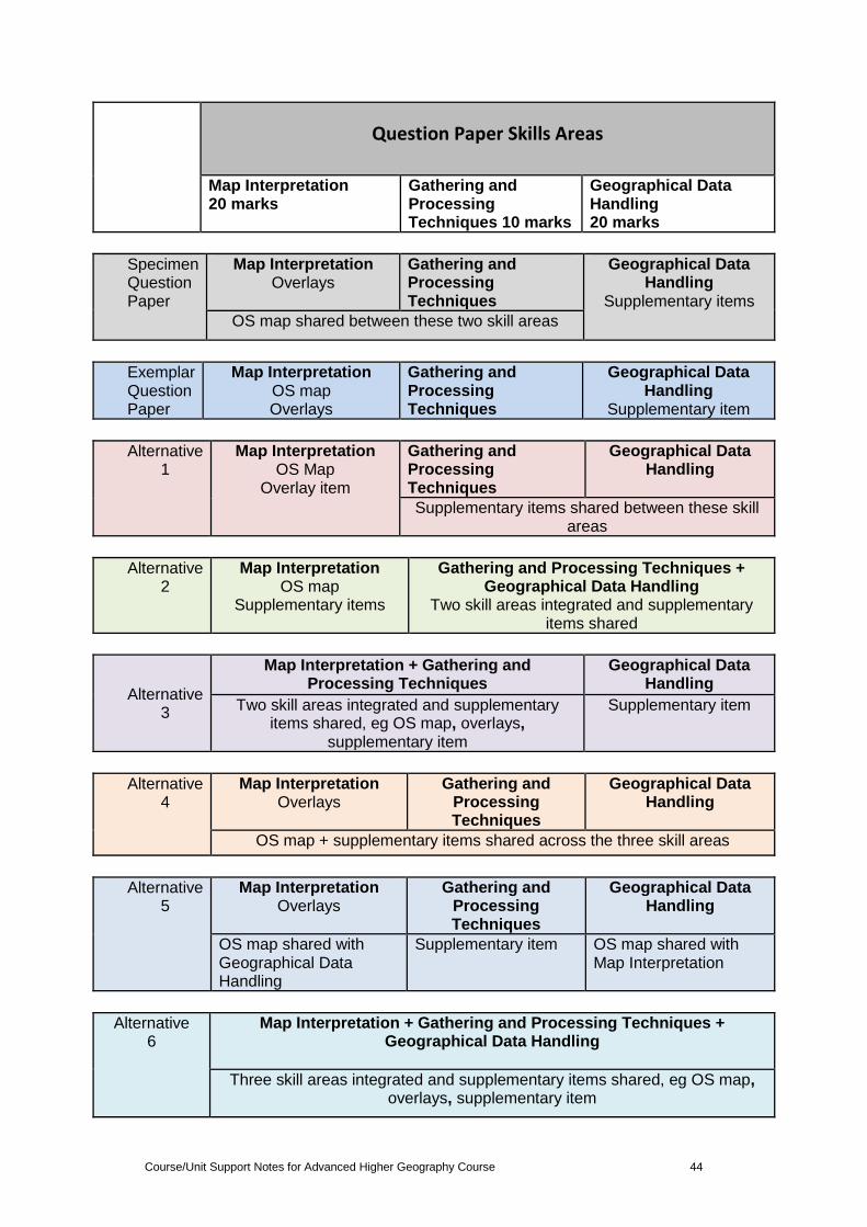
Course/Unit Support Notes for Advanced Higher Geography Course 44
Question Paper Skills Areas
Map Interpretation 20 marks
Gathering and Processing Techniques 10 marks
Geographical Data Handling 20 marks
Specimen Question Paper
Map Interpretation Overlays
Gathering and Processing Techniques
Geographical Data Handling
Supplementary items
OS map shared between these two skill areas
Exemplar Question Paper
Map Interpretation OS map Overlays
Gathering and Processing Techniques
Geographical Data Handling
Supplementary item
Alternative 1
Map Interpretation OS Map
Overlay item
Gathering and Processing Techniques
Geographical Data Handling
Supplementary items shared between these skill areas
Alternative 2
Map Interpretation OS map
Supplementary items
Gathering and Processing Techniques + Geographical Data Handling
Two skill areas integrated and supplementary items shared
Alternative 3
Map Interpretation + Gathering and Processing Techniques
Geographical Data Handling
Two skill areas integrated and supplementary items shared, eg OS map, overlays,
supplementary item
Supplementary item
Alternative 4
Map Interpretation Overlays
Gathering and Processing Techniques
Geographical Data Handling
OS map + supplementary items shared across the three skill areas
Alternative 5
Map Interpretation Overlays
Gathering and Processing Techniques
Geographical Data Handling
OS map shared with Geographical Data Handling
Supplementary item OS map shared with Map Interpretation
Alternative 6
Map Interpretation + Gathering and Processing Techniques + Geographical Data Handling
Three skill areas integrated and supplementary items shared, eg OS map, overlays, supplementary item
Course/Unit Support Notes for Advanced Higher Geography Course 45
Appendix 1: Reference documents The following reference documents will provide useful information and
background.
Assessment Arrangements (for disabled candidates and/or those with
additional support needs) — various publications are available on SQA’s
website at: www.sqa.org.uk/sqa//14977.html.
Building the Curriculum 4: Skills for learning, skills for life and skills for work
Building the Curriculum 5: A framework for assessment
Course Specification
Design Principles for National Courses
Guide to Assessment
Principles and practice papers for curriculum areas
SCQF Handbook: User Guide and SCQF level descriptors
SQA Skills Framework: Skills for Learning, Skills for Life and Skills for Work
Skills for Learning, Skills for Life and Skills for Work: Using the Curriculum
Tool
Coursework Authenticity: A Guide for Teachers and Lecturers
Course/Unit Support Notes for Advanced Higher Geography Course 46
Administrative information
Published: May 2015 (version 2.0)
History of changes to Advanced Higher Course/Unit Support Notes Course details
Version Description of change Authorised by
Date
2.0 Minor changes to pages 1-11 in line with changes to mandatory documents. Extensive changes to the rest of the document based on widespread consultation/development of Course/Unit materials.
Qualifications Development
Manager
May 2015
This document may be reproduced in whole or in part for educational purposes
provided that no profit is derived from reproduction and that, if reproduced in part,
the source is acknowledged. Additional copies can be downloaded from SQA’s
website at www.sqa.org.uk.
Note: You are advised to check SQA’s website (www.sqa.org.uk) to ensure you
are using the most up-to-date version.
© Scottish Qualifications Authority 2015