ae-043-05.1 2003 -en-lai - europa · non-pointed natural stone or embanked earth within or directly...
TRANSCRIPT

EUROPEAN COMMISSIONEUROSTAT
Directorate F: Agricultural, environmental, food and regionalstatisticsUnit F3: Environment and sustainable development
Doc. AE/WG/043/05.1 (2003)Original in DE, available in EN and FRPoint 5.1 of the agenda
TAPAS 2001 & 2002 – GermanyLinear Landscape Elements as Agricultural Environmental Indicators
Hans Peter Piorr & M.Reutter – UASE (DE)
Meeting of the
"Agriculture and Environment" Sub-Group
of the Agricultural Statistics Committee
and of the "Environment and Sustainable Development" Working Group
Joint Eurostat/EFTA Group
Meeting of 29 and 30 October 2003
BECH building – Ampère Room

AE/WG/043/05.1 (2003) Page 2
Linear Landscape Elements as Agricultural EnvironmentalIndicators
1 AbstractUnder the LAI (Linear Landscape Elements as Agricultural Environmental Indicators)project, an inventory was made of existing systems for recording the length of hedges andwalls, and their suitability for long-term monitoring purposes was evaluated. As an exampleexercise, data were evaluated at NUTS 3 level (rural districts).Also examined was the extent to which an expert survey can be used to derive trends inrelation to the agricultural landscape. With the aid of a GIS projection, the results obtained atNUTS 3 level can be interpreted in respect of the landscape.Finally, a method was devised which can be generally recommended for the continuousupdating of statistics on linear landscape elements at national and international level.
2 Introduction and objectivesThe long-term realignment in the allocation of Community aid for the agricultural sectorplaces particular importance on environmental outputs. It was announced that data wererequired on the length of the hedges and walls in the agricultural landscape and on the densityof linear landscape elements, so as to be able to gauge habitat quality and bio-diversity(Official Journal of the European Union 2001, European Commission). The foundation stonewas thus laid for taking into account, in the future allocation of agricultural aid, the protectionof landscape elements as an ecological measure.
The project set out to:Ø make an inventory of existing systems for recording walls and hedges and examine the
possible usability of those systems for long-term monitoring purposes;Ø carry out a nation-wide survey at NUTS 31 level in order to
(i) gauge opinion concerning the monitoring of landscape elements,(ii) find out whether data are already available for use at NUTS 3 level,(iii) test the extent to which expert statements can be used to derive trends regarding themonitoring of landscape elements,
Ø report on the presence in German agricultural landscapes of hedges and walls (where dataare available) at NUTS 3 level and, finally,
Ø devise a method which can be generally recommended for continually updating statisticson linear landscape elements at national and international level.
1 NUTS = Nomenclature des unités territoriales statistiques (Nomenclature of Territorial Statistical Units). In Germany,NUTS 3 corresponds to district (Kreis) level.

AE/WG/043/05.1 (2003) Page 3
3 Definitions
3.1 HedgesThe following points were discussed:
• integration of the various hedge forms;• hedges alongside watercourses;• the taking into account of nature conservation aspects;• demarcation from related landscape elements;• ownership issues;• usability of the definition also for the evaluation of aerial photographs.
The following definition was arrived at:Hedges in the agricultural landscape are linear landscape elements which exhibit acontinuous row of woody plants and are either rooted in or border agricultural land. Thisdefinition thus embraces regionally differing hedge forms, such as hedgerows, tree hedges,hedges on compactly stacked stone walls (Steinriegel) or piled stones, as well as field andwind-break hedges. Excluded, therefore, are rows and avenues of trees which are not madefully continuous by the inclusion of woody plants, as well as field copses.2
Also included are hedges which:• do not fall under the responsibility of a farmer but which run along the sides of field paths
and are the responsibility of the local commune;• were planted for highways departments along the sides of roads as protection against
emissions;• stand as the linear remainder of wooded water meadows along the side of utilised
agricultural areas;• take the form of dense rows of overgrown woody plants along the sides of ditches,
streams and rivers;• do not comprise autochthonous, appropriately located woody plants.
The project report contains suggestions for the demarcation of hedges from related elementsand for the taking into account of gaps in hedges.
2 Also excluded from the definition, initially, were wooded water fringes. Over the course of the project, however, it wassuggested that it would be better to integrate these into the definition, but to designate them as such so as to avoid possibleduplicate evaluations in the event of watercourses being taken into account as agricultural environmental indicators. Likewiseadded to the definition in the course of the project were hedges which directly border utilised agricultural areas. As a rule, itis hardly possible to establish with certainty whether hedges are actually in such areas or border them.

AE/WG/043/05.1 (2003) Page 4
3.2 WallsThe following points of discussion arose concerning the definition of walls:
• integration of the various forms and origins of walls;• differentiation according to nature-conservation criteria;• taking into account walls within villages;• taking into account non-masonry terrace edges in loess areas• recording vegetation-covered and non-covered walls;• difficulty of recognising vegetation-covered walls on aerial photographs.
The following definition was arrived at:To be considered as walls in the agricultural landscape are linear elements of pointed andnon-pointed natural stone or embanked earth within or directly bordering utilisedagricultural areas. The retaining walls (dry walling) often to be found in vineyards are thusincluded in this definition, as are regionally important compactly stacked stone walls(Steinriegel) and embankments without vegetation cover.• only walls which were originally erected as such and later naturally became covered by
vegetation are counted as walls;• walls within villages are not included in the definition.
For monitoring purposes, it would be appropriate to differentiate the elementsaccording to nature-conservation criteria, but this is ultimately only possible if a veryexpensive and time-consuming terrestrial inventory is made.Overall, the definition also depends on the recording system and will therefore have tobe adapted in a pragmatic manner.

AE/WG/043/05.1 (2003) Page 5
4 MethodologyEvaluation of the existing recording systemsFor this purpose, an inventory was made of the existing systems for recording hedges andwalls in Germany's agricultural landscapes, and their advantages and disadvantages weredocumented in terms ofi) ascertaining the status quo nation-wideii) and of their usability for long-term monitoring purposes.The current cartographic systems used by the Länder were assessed and compared.The competent experts were asked about the procedures applied and about the usability of thedata.As an example exercise, existing data were evaluated.
Nation-wide survey at NUTS 3 levelLetters were written to all of Germany's 323 Landkreise (rural administrative districts - NUTS3 level), asking them to forward the questionnaires to their agricultural and natureconservation authorities. The questionnaire was deliberately kept short. The intention was toenable respondents to answer the questions quickly and directly without having to consultfurther information sources, and thus to achieve the highest possible rate of participation. Inorder to make the necessary impact, the Deutsche Landkreistag (confederation of Germanrural administrative districts) was also involved; it represents the interests of the Landkreise.The information thus gathered was input into a database (ACCESS) and then visualised in aGeographic Information System in a reproducible, transparent and updateable manner. Theresults were then projected to landscape (natural areas) level. For this purpose, the system ofunit demarcation used by the Federal Office for Nature Conservation (Bundesamt fürNaturschutz - BfN) on the basis of Meynen & Schmitthüsen (1953-1962) (see geodata, page4) was employed. It is thus possible to interpret the results in a landscape-specific way, and inaddition information is obtained which is valid for the whole of Germany.
Questions covered by the survey:• Are there hedges/walls in the agricultural landscape of the rural administrative district?• What legal status do these hedges/walls have?• What are the functions of these elements judged to be?• Are data available on hedges/walls at rural administrative district level?• What landscape elements are regionally important?
For most of the questions, multiple-choice answers were provided. Answers were to beweighted according to priorities (e.g. high – medium – low), so as to be able to gauge thesignificance of the respective parameters.

AE/WG/043/05.1 (2003) Page 6
Figure 1: Methodology of the projection
Projection of the survey results from the rural administrative districtsThe results from the rural administrative districts - in this case taking the example of theassessment of the cultural-historical importance of hedges for the particular ruraladministrative district - are projected for Germany's natural areas (Figure 1). To this end, thesurface areas of the rural administrative districts are intersected with those of the naturalareas. A surface-area-weighted average is then calculated from the surface-area shares of therural administrative districts for which the corresponding results are available from thesurvey. This surface-area-weighted average is then projected for the total surface of thenatural area.
SoftwareSurvey results and other data were deposited in an ACCESS database. The maps wereproduced using ArcView® Version 3.2.
Naturräume Deutschlands: Quelle: LANIS-Bund, Bundesamt für Naturschutz, 2002Administrative Grenzen Deutschlands: Quelle: ATKIS®,VG250: Copyright© Bundesamt für Kartographie und Geodäsie, 2001
Projekt: Lineare Landschaftselemente als Agrar-Umwelt-Indikatoren (LAI)
Erstellt am 26.07.2002 von M. Reuttermit der Version ArcView®3.2a
0 30 60 Kilometer
N
Kulturhistorische Bedeutungin den Naturräumen
eher geringmittelmittel bis hochhoch
Kulturhistorische Bedeutung in den Landkreisen
hochmittelgering
AE/WG/043/05.1 (2003) Page 7
Results
4.1 Recording systems in GermanyThe following systems are used for recording landscape elements in Germany:• Biotope mapping of the Länder:
Terrestrial mapping of biotopes which are important for nature conservation(e.g.. HÖLL & BREUNING 1995)⇒ The biotope maps provide information which is analysed to establish the status quo ofhedges and walls as linear landscape elements. In terms of nation-wide comparison,however, their data exhibit a high degree of temporal and qualitative heterogeneity.
• Biotope/land-use type mapping of individual Länder:Full-area-coverage mapping using colour-infrared (CIR) aerial photographs. (e.g.FEDERAL OFFICE FOR NATURE CONVERSATION 2002)⇒ Analysis of aerial photographs is a particularly suitable method for the purelyquantitative recording of hedge length and width. As this type of analysis was not carriedout with full area coverage for all Länder, these data can only be used to a limited extentfor determining the nation-wide status quo.
• Authoritative Topograpic-Cartographic Information System (ATKIS):Digital data of the regional (Land) surveyors offices.(ARBEITSGEMEINSCHAFT DER VERMESSUNGSVERWALTUNG (WORKING GROUP OF SURVEYORS OFFICES 2001)⇒ For the long-term, the ATKIS data are of interest as a well standardised data sourcefor hedges, but not for walls. However, they have to be specifically supplemented bydetailed information.
• Data from the LUCAS (Land Use / Cover Area Frame Statistical Survey) project:EU-wide terrestrial sampling system, using an 18 x 18 km grid, for improvingagricultural statistics. (EUROPEAN COMMUNITIES 2003)⇒ An interesting data source; the project is still at the trial phase, however.
• Other data sources:⇒ Regional planning documents, data from aid programmes and regional expertknowledge can be used to discern a trend in relation to hedges and walls.
Conclusion:The existing recording systems can be used in order to determine the status quo. Particularlywell suited to this purpose are the biotope and land-use type mapping systems. The aim ofthese systems is to make an initial inventory and, in the case of biotope mapping, also to makean assessment of the biotopes occurring in the landscape. If these surveys are continued atregular intervals, long-term changes could be highlighted. Such long intervals would besuitable for regular international environmental reporting at EU level or for the OECD.ATKIS is even aiming for 5-year updates.

AE/WG/043/05.1 (2003) Page 8
For gauging the success of aid measures, short intervals would make sense. To this end,other data have to be drawn on. It would appear appropriate in this context to take intoaccount the data from the aid programmes for the EU's agri-environment measures, in order toprovide proof of outputs benefiting the landscape.
Table 1: Comparison of existing recording systems
Timeliness Nation-wide availability Comparability of results between theLänder
Biotope mapping - + -Biotope and land-use
type mapping + - +
ATKIS + + + + +LUCAS + + + + ++
4.2 Data at rural administrative district levelWithin the framework of the project, some of the various data sources mentioned above wereassessed, taking the example of hedges For the eastern German Länder, full-area mapping isavailable, on the basis of infra-red aerial photographs, as a digital biotope and land-use typemap. These were analysed for eastern Germany in relation to hedge lengths (PIORR, REUTTER& MALECK 2003). Table 2 shows a sample analysis for a number of rural administrativedistricts in Brandenburg, while Figure 2 shows extracts from the map.
Table 2: Hedge length/North Brandenburg rural administrative districts (status 1991-1993)
Ruraladministrativedistrict
Length (km)
Prignitz 739
Uckermark 604Ostprignitz-Ruppin 288Oberhavel 204Barnim 172
Own analysis of data on environmental situation in the Land of Brandenburg3

AE/WG/043/05.1 (2003) Page 9
Hecken der FeldflächenKreisgrenzen
N
EW
S
20 0 20 40 Kilometer
Verteilung von Feldhecken in Nord-Brandenburg
AckerflächeHecken0 2000 Met er
N
EW
S
Ausschnitt aus dem Landkreis Uckermark
Figure 2: Extracts from an evaluation of data on the environmental situation in the Land of Brandenburg3
3 See Geodata, page 4
AE/WG/043/05.1 (2003) Page 10
4.3 Continuous administrative data for monitoringIn the survey, the percentages of the participating rural administrative districts at leastpartially able to provide information after analysing the available data were as follows:48 % provided information on the annual planting of new hedges,41 % on the annual clearing of hedges and45 % on the annual tending/restoration of hedges.
Similarly, of the rural administrative districts which replied that they have walls in theagricultural landscape, the percentages able to report on those walls after analysing theavailable data, were as follows:28 % reported on the number of new walls built annually,29 % on annual wall removals and36 % on annual care and maintenance work.
4.4 Success of the nation-wide surveyOverall, completed questionnaires were received for 57% of the rural administrativedistricts. This testifies to a high degree of interest on the part of the Landkreise.Answers covering the full area were not to be expected. Nevertheless, some trends can bederived from the answers supplied.The quality of the answers could certainly be further enhanced by carrying out repeat surveysand thus ensuring deeper expert involvement. Use of the Delphie method should also beaimed for (SCHLUMPRECHT et al. 2001).
4.5 Occurrence of hedges in the German agricultural landscapeHedges were classified as the most important landscape element in German agriculturallandscapes. They are to be found in all rural administrative districts. Walls, on the other hand,tend more to be of regional significance. The following Figure shows the distribution of wallsin Germany.

AE/WG/043/05.1 (2003) Page 11
Ländergrenzen
eher nichtwenige/eher vereinzeltja
Gibt es Mauern in der Agrarlandschaft?
Mauern in den Agrarlandschaften Deutschlands
Methode:Befragung der Landkreise (eigene Erhebung)Projektion der Ergebnisse in die NaturräumeFremddaten:Naturräume Deutschlands: Quelle: LANIS-Bund, Bundesamt für Naturschutz, 2002Administrative Grenzen Deutschlands: Quelle: ATKIS®,VG250: Copyright© Bundesamt für Kartographie und Geodäsie, 2001
Projekt: Lineare Landschaftselemente als Agrar-Umwelt-Indikatoren (LAI)
Erstellt am 26.07.2002 von M. Reuttermit der Version ArcView®3.2a
0 200 400 Kilometer
N
Figure 3: Distribution of walls in Germany's agricultural landscapes, as determined as a result of anation-wide expert survey.
AE/WG/043/05.1 (2003) Page 12
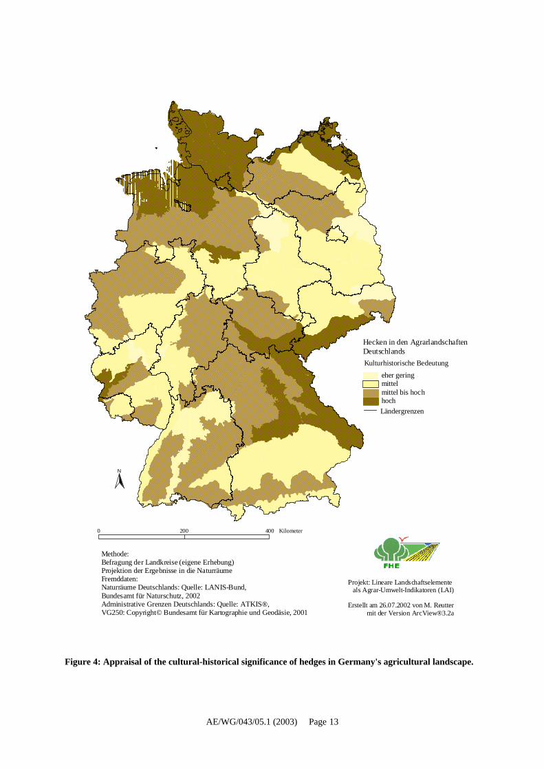
4.6 Appraisal of the functions of hedges and walls in the agricultural landscapeThroughout Germany, hedges are of particular importance as a habitat and for the interlinkingof biotopes. In assessing the protective functions of hedges against water and wind erosion, asin assessing their cultural-historical importance, account has to be taken of marked regionalvariations.Walls are appraised differently from one region to another. This regionality needs to be takeninto account when drawing up future aid programmes.Figure 4 below shows, by way of example, the projected appraisal by experts of the cultural-historical importance attaching to hedges in Germany.
4.7 Legal status of linear landscape elementsNeither hedges nor walls have general legal protection in Germany.- Hedges in dry locations are protected throughout Germany.- Depending on the particular Land, special types of hedges are protected.- In some Länder, all hedges are protected.- Walls (both dry walling and compactly stacked stone walls [Steinriegel]) are protected in
some but not in all Länder.- More recently built stone walls are usually not protected.
Hedges and walls come under the scope of the Federal Protection of Nature Act(Bundesnaturschutzgesetz). Under Article 18 of that Act, any intervention requiresauthorisation. In the event of unavoidable damage to the natural environment or landscape,compensation and replacement measures are obligatory.
AE/WG/043/05.1 (2003) Page 13
Ländergrenzen
Hecken in den AgrarlandschaftenDeutschlands
Methode:Befragung der Landkreise (eigene Erhebung)Projektion der Ergebnisse in die NaturräumeFremddaten:Naturräume Deutschlands: Quelle: LANIS-Bund, Bundesamt für Naturschutz, 2002Administrative Grenzen Deutschlands: Quelle: ATKIS®,VG250: Copyright© Bundesamt für Kartographie und Geodäsie, 2001
Projekt: Lineare Landschaftselemente als Agrar-Umwelt-Indikatoren (LAI)
Erstellt am 26.07.2002 von M. Reuttermit der Version ArcView®3.2a
0 200 400 Kilometer
N
eher geringmittelmittel bis hochhoch
Kulturhistorische Bedeutung
Figure 4: Appraisal of the cultural-historical significance of hedges in Germany's agricultural landscape.
AE/WG/043/05.1 (2003) Page 14
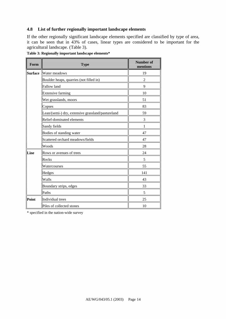
4.8 List of further regionally important landscape elementsIf the other regionally significant landscape elements specified are classified by type of area,it can be seen that in 43% of cases, linear types are considered to be important for theagricultural landscape. (Table 3).Table 3: Regionally important landscape elements*
Form Type Number ofmentions
Water meadows 19
Boulder heaps, quarries (not filled in) 2
Fallow land 9
Extensive farming 10
Wet grasslands, moors 51
Copses 83
Lean/(semi-) dry, extensive grassland/pastureland 59
Relief-dominated elements 3
Sandy fields 1
Bodies of standing water 47
Scattered orchard meadows/fields 47
Surface
Woods 28
Rows or avenues of trees 24
Rocks 5
Watercourses 55
Hedges 141
Walls 43
Boundary strips, edges 33
Line
Paths 5
Individual trees 25Point
Piles of collected stones 10
* specified in the nation-wide survey

AE/WG/043/05.1 (2003) Page 15
5 Conclusions
5.1 Particular advantages of the survey of authoritiesA striking feature of the survey was the large number of references to difficulties currentlybeing encountered in the planting of new, and care and maintenance of existing field hedges.One serious problem is that hedges which have spread out into the field areas over the yearsnow have to be cut back because the surface areas of the fields themselves no longercorrespond to those entered in the land register. Following EU checks, there is a possibility offines being imposed in many places. In Thuringia, therefore, the statutory protection ofhedges is now to be lifted to enable farmers to restore original field sizes.
The survey was thus also used as a forum for reporting on problems which can also arise as aresult of EU aid directives, for example.
⇒ Inclusion of local expert knowledge
By dint of setting up such an expert information system, good contacts can be establishedfrom the bottom up. This method of information processing appears to be a very efficient wayof ensuring that local interests and regional objectives are duly taken into account. Overall, aninternationally recognised goal is thus pursued, namely to maintain and develop the landscapein a way that harnesses the historical and natural heritage together with the regionalrequirements and goals of the people who live there.The results obtained from the survey at rural district level are a very suitable basis for nationaland international reporting. With this method, nation-wide trends can be ascertained. Thesurvey method is suitable for reporting purposes as it can be used in a rapid, standardised andcost-effective manner. It supplies results which can be clearly interpreted and thus enableseffective measures to be derived.
5.2 Proposed method for the continuous updating of statistics on linear landscapeelements at national and international level
Objectives of monitoring:i) To provide regular national and international reports, at long intervals, on the state of the
agricultural landscape.ii) To reward farmers at short intervals for their environmental outputs.
The first step is to determine the status quo. On this basis, changes will be registered regularlyat three-year intervals. The purpose of ascertaining short-term changes is to highlight farmers'environmental outputs. In particular, the effort needed to tend landscape elements will betaken into account. After a period of 15 years, the state of the elements will once again bedetermined. This is necessary, because the recording of annual changes will not includefigures on how many elements disappear owing to lack of care. For example, hedges may turninto copses and walls may become overgrown.

AE/WG/043/05.1 (2003) Page 16
There are thus two phases of monitoring: the inventory of the current status and regularchecks to ascertain changes (Figure 5). A particularly suitable way of ascertaining the statusquo is to analyse aerial-photograph or satellite data (see also STATISTISCHES BUNDESAMT[Federal Statistical Office], 1998). Another possibility would be the long-term observation ofreference areas or sampling at regional level. It is thus possible to obtain (albeit relativelyheterogeneous) data very cost-effectively, as explained in this report, if the already existingdata sources are accepted as proof.
Figure 5: Landscape-elements monitoring scheme
In order to determine short-term changes and farmers' outputs, existing administrative datashould be drawn on. The underlying assumption is that the planting/building of new landscapeelements and the maintenance of existing ones are usually carried out using aid money, so thatfigures will be available. For the removal of landscape elements, authorisation usually has tobe obtained from the competent nature-conservation authority. Here again, documentationmust be available. By collating these data, information is obtained on current trends in thedevelopment of landscape elements. A further simplification would be for the authoritiessimply to provide trend reports on whether the number of particular landscape elements isrising markedly, just rising, decreasing markedly or just decreasing.
kurzfristige Veränderungen Verwaltungsdaten zur Honorierung der L eistungen der Landwirtschaft
Status quo Luftbild- oder Satellitenbildauswertung für die Umweltberichterstattung
Erneute Zustandsermittlung Luftbild- oder Satellitenbildauswertung für die Umweltberichterstattung
15 Jahre
AE/WG/043/05.1 (2003) Page 17
6 ReferencesOFFICIAL JOURNAL OF THE EUROPEAN UNION (2001): Commission Decision of 12 Februaryapproving the 2001 Technical Action Plan for improving agricultural statistics (referencenumber: C (2001)356)
ARBEITSGEMEINSCHAFT DER VERMESSUNGSVERWALTUNG (WORKING GROUP OF SURVEYORSOFFICES) (2001): Amtlich Topographisch-Kartographisches Informationssystem ATKIS-Objektartenkatalog (Authoritative Topographic-Cartographic Information System - Object-type Catalogue, ATKIS-OK) based on a Digital Landscape Model, Status 2001.http://www.atkis.de/dstinfo/dstinfo2.dst_gliederung
BUNDESAMT FÜR NATURSCHUTZ (Federal Office for Nature Conservation (2002): Systematikder Biotoptypen- und Nutzungstypenkartierung (Kartieranleitung) / A System for SurveyingBiotope and Land Use Types (Survey Guide). Schriftenreihe für Landschaftspflege undNaturschutz (series of publications on landscape protection and nature conservation), No 73.Bonn-Bad Godesberg
EUROPEAN COMMUNITIES (2003): The LUCAS Survey – European statisticians monitorterritory; working papers and studies. Luxembourg. http://europa.eu.int/comm/eurostat/
HÖLL, N. & T. BREUNING [Publisher] (1995): Biotopkartierung Baden-Württemberg –Ergebnisse der landesweiten Erhebungen 1981 – 1989. (Biotope mapping in Baden-Württemberg) Supplement to the publication Naturschutz und Landschaftspflege Baden-Württ. (Nature Conservation and Landscape Protection in Badenwürttemberg) 81. Karlsruhe.544 pages.
COMMISSION OF THE EUROPEAN COMMUNITIES 2001 Communication from the Commission tothe Council and the European Parliament: Statistical Information needed for Indicators tomonitor the Integration of Environmental concerns into the Common Agricultural Policy,COM(2001) 144 final, Brussels.
PIORR, H.-P., M. REUTTER & CH. MALECK (2003): Hedges for Agricultural Statistics (notpublished).
SCHLUMPRECHT, H. V., D. SCHUPP, P. SÜDBECK (2001): Methoden zur Entwicklung einesIndikators "Bestandsentwicklung ausgewählter Vogelarten". Wie lassen sich faunistischeDaten zu aussagefähigen Kenngrößen aggregieren? (Methods for developing a "trends innumbers of selected bird species" indicator. How can faunistic data be aggregated to givemeaningful variables?) Naturschutz und Landschaftsplanung, vol. 33, No 11. pp.. 333-343
STATISTISCHES BUNDESAMT (Federal Statistical Office (1998): Biodiversität und Statistik -Ergebnisse des Pilotprojektes zur Ökologischen Flächenstichprobe (Biodiversity andStatistics - results of a pilot project on ecological area sampling. Separate reprint fromWIRTSCHAFT UND STATISTIK (Economics and Statistics) 1/1998. Wiesbaden