aerial vehicle unmanned aircraft systems/unmanned uas...
TRANSCRIPT
UAS Photogrammetry
Photogrammetric Applications Based on Unmanned Aircraft Systems/Unmanned
Aerial Vehicle
https://www.youtube.com/watch?v=-ucLIckILT4

FAA Resources● UAS (link)● Dos and Don’ts (pdf)● B4UFLY App (link)
● Using term "aircraft" invokes a regulatory environment● Educational use is considered as for business
purpose - so educational use is regulated● Public institutions must get a certificate of
authorization (COA) - so FAA Air Traffic Control facilities are aware of proposed UAS operations
● Or, get a section 333 exemption first
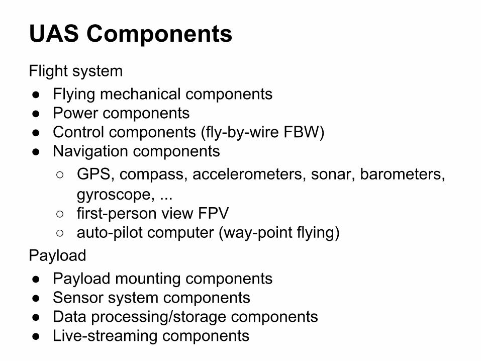
UAS ComponentsFlight system● Flying mechanical components● Power components● Control components (fly-by-wire FBW)● Navigation components
○ GPS, compass, accelerometers, sonar, barometers, gyroscope, ...
○ first-person view FPV○ auto-pilot computer (way-point flying)
Payload● Payload mounting components● Sensor system components● Data processing/storage components● Live-streaming components
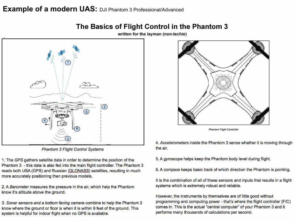
Example of a modern UAS: DJI Phantom 3 Professional/Advanced
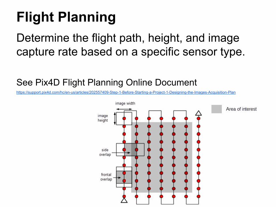
Flight PlanningDetermine the flight path, height, and image capture rate based on a specific sensor type.
See Pix4D Flight Planning Online Documenthttps://support.pix4d.com/hc/en-us/articles/202557409-Step-1-Before-Starting-a-Project-1-Designing-the-Images-Acquisition-Plan

Information Needed for Flight Planning
Project criteria● Precision level (spatial resolution) of the final product● Study area boundariesSystem criteria● Dimension of the digital (aerial) photos/sensors● Focal length of the sensor (camera lens)● Size of required overlap area (60% of side overlap +
80% of forward overlap)● Flight time, speed limitsEnvironment criteria (lots of topics for research projects!)● FAA regulations● Terrain, vegetation, land-cover, target forms, etc.● Flight safty, hazardous conditions
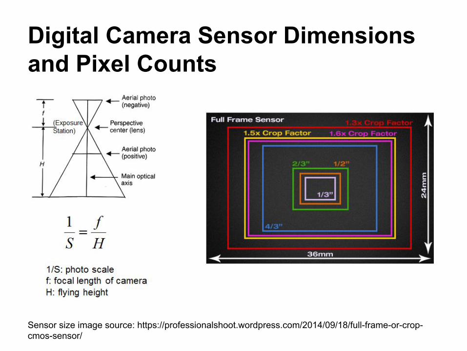
Digital Camera Sensor Dimensions and Pixel Counts
Sensor size image source: https://professionalshoot.wordpress.com/2014/09/18/full-frame-or-crop-cmos-sensor/
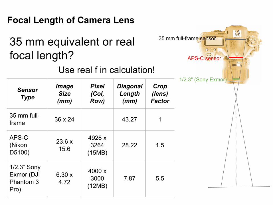
Focal Length of Camera Lens
35 mm equivalent or real focal length?
Use real f in calculation!
35 mm full-frame sensor
APS-C sensor
1/2.3" (Sony Exmor)
Sensor Type
Image Size (mm)
Pixel (Col, Row)
Diagonal Length (mm)
Crop (lens) Factor
35 mm full-frame 36 x 24 43.27 1
APS-C (Nikon D5100)
23.6 x 15.6
4928 x 3264
(15MB)28.22 1.5
1/2.3” Sony Exmor (DJI Phantom 3 Pro)
6.30 x 4.72
4000 x 3000
(12MB)7.87 5.5
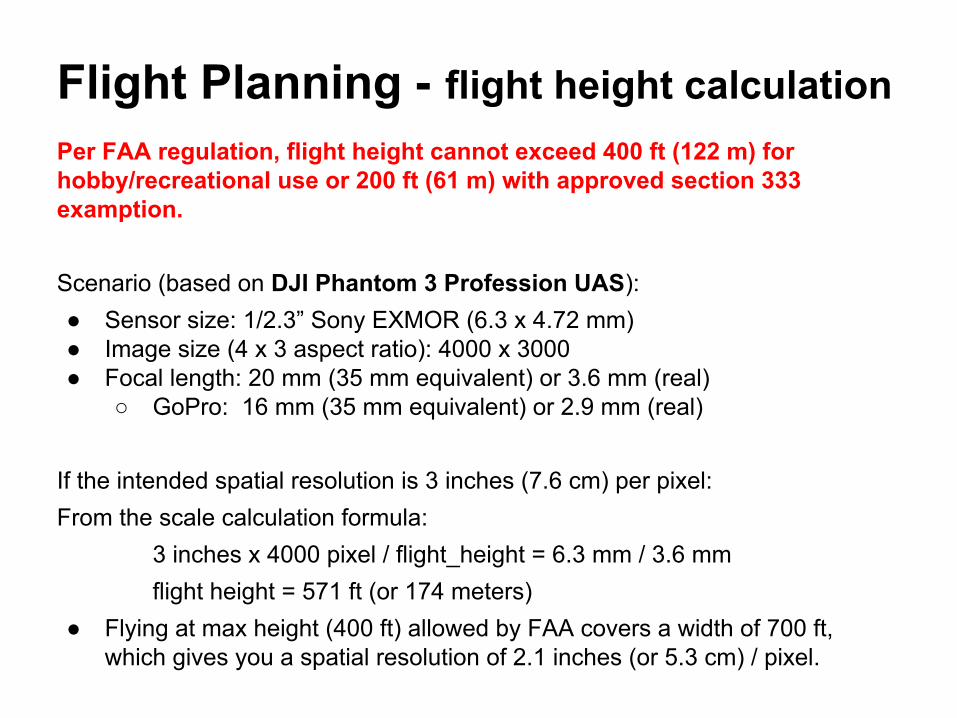
Flight Planning - flight height calculation Per FAA regulation, flight height cannot exceed 400 ft (122 m) for hobby/recreational use or 200 ft (61 m) with approved section 333 examption.
Scenario (based on DJI Phantom 3 Profession UAS):● Sensor size: 1/2.3” Sony EXMOR (6.3 x 4.72 mm)● Image size (4 x 3 aspect ratio): 4000 x 3000● Focal length: 20 mm (35 mm equivalent) or 3.6 mm (real)
○ GoPro: 16 mm (35 mm equivalent) or 2.9 mm (real)
If the intended spatial resolution is 3 inches (7.6 cm) per pixel:From the scale calculation formula:
3 inches x 4000 pixel / flight_height = 6.3 mm / 3.6 mmflight height = 571 ft (or 174 meters)
● Flying at max height (400 ft) allowed by FAA covers a width of 700 ft, which gives you a spatial resolution of 2.1 inches (or 5.3 cm) / pixel.
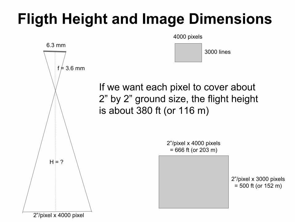
Fligth Height and Image Dimensions6.3 mm
f = 3.6 mm
H = ?
2”/pixel x 4000 pixel
4000 pixels
3000 lines
2”/pixel x 4000 pixels= 666 ft (or 203 m)
2”/pixel x 3000 pixels= 500 ft (or 152 m)
If we want each pixel to cover about 2” by 2” ground size, the flight height is about 380 ft (or 116 m)

Flight Planning - photo dimensions(Calculation is based on DJI Phantom 3 Pro camera)
From the scale calculation formula, we know that UAS photos captured at 380 ft cover an area of 666 x 500 ft (or 203 x 152 m)
Photo width: 4000 pixels x 2 inches/pixel = 666 ft (or 203 m)Photo height: 3000 pixels x 2 inches/pixel = 500 ft (or 152 m)
Overlapped length between neighboring photos:Forward (along flight path) 80%: 500 ft x 80% = 400 ft (or 122 m)Side (between flight paths) 60%: 666 ft x 60% = 400 ft (or 122 m)
500’
666’
400’
400’100’
266’
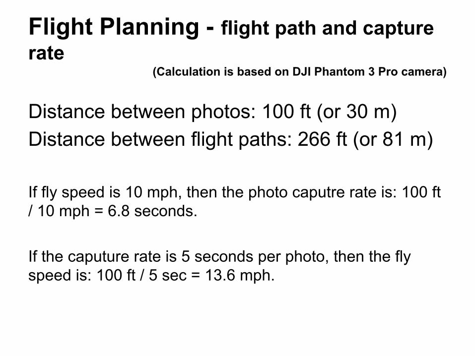
Flight Planning - flight path and capture rate
(Calculation is based on DJI Phantom 3 Pro camera)
Distance between photos: 100 ft (or 30 m)Distance between flight paths: 266 ft (or 81 m)
If fly speed is 10 mph, then the photo caputre rate is: 100 ft / 10 mph = 6.8 seconds.
If the caputure rate is 5 seconds per photo, then the fly speed is: 100 ft / 5 sec = 13.6 mph.

Flight Planning - flight time and image file size
If the study area is 1 mile by 1 mile and the image capture rate is 5 seconds per photo, then:
1) the total number of photos is:5280 ft / 266 + 2 = 22 (flight paths)5280 ft / 100 + 2 = 55 (photos per path)55 x 22 = 1210 photos
2) the total flight time is:1210 photos x 5 seconds = 100 minutes
3) the total file size is:1210 photos x 11.5 MB = 13.5 GB

Preflight ChecklistMake sure all firmwares are up-to-date.Setup
● Verify no sources of potential interference (large metal surfaces, etc.) ● Verify no ferromagnetic materials on person or near UAV● UAV gimbal clamp removed and stored● Micro SD card inserted into UAV camera slot● Insert UAV battery; Check UAV battery status fully charged● Check propellers are in good condition; Install propellers on proper axis● Mount monitor (mobile device) and connect to controller● Position controller antennas properly● Set controller flight mode to “P” (manual) position
Power Up● Controller power ON; Controller Battery status OK (fully charged)● UAV on level surface (appropriate HOME position) ● Orient UAV nose pointing away from operator position● UAV power ON; UAV status OK and ready; Controller LED green● Controller status OK (no errors)● Launch DJI Pilot app; If new launch area, tap “Calibrate” option and follow on-screen instructions ● Tap “Camera” option; Adjust camera settings as desired
Ready for Takeoff● DJI Pilot app flight status ok to go (Safe to fly – GPS)● Both control sticks to lower-inner position to start motors (CSC) ● Execute auto or manual takeoff and move to hover position (~2m) for 30 seconds● Check stability of UAV● All checks OK – ready to go
Data Source: http://www.droneflyers.com/images/UAVPreflightCk.pdf
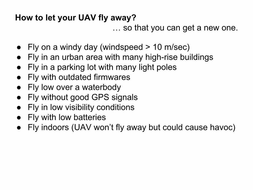
How to let your UAV fly away?… so that you can get a new one.
● Fly on a windy day (windspeed > 10 m/sec)● Fly in an urban area with many high-rise buildings● Fly in a parking lot with many light poles● Fly with outdated firmwares● Fly low over a waterbody● Fly without good GPS signals● Fly in low visibility conditions● Fly with low batteries● Fly indoors (UAV won’t fly away but could cause havoc)

Structure from Motion (SfM)The basic assumption of image-based 3-D reconstruction is that the images contain the 2-D projections of a given object from different viewpoints, and the 3-D geometry of the object can be calculated via triangulation of the corresponding (tie) points of the object in the images.
The key challenge lies in the automated identification of the correspondences among the images. Once the corresponding points of different images are determined, the 3-D location of those points and the camera motion of the images can be retrieved.
SfM replies on computer vision algorithms to make efficient pixelwise dense matching possible.
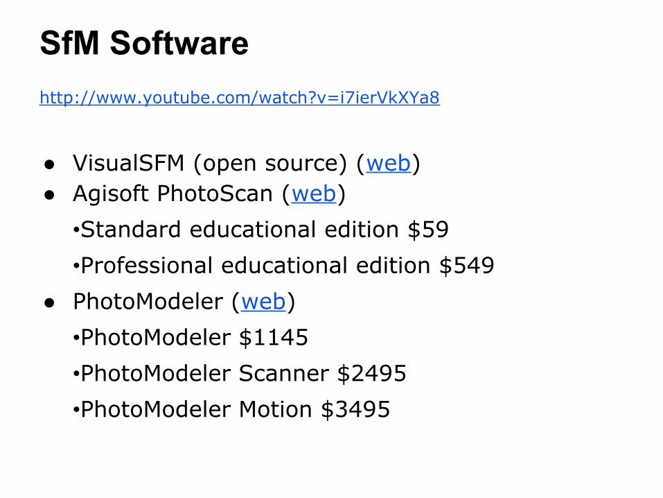
SfM Softwarehttp://www.youtube.com/watch?v=i7ierVkXYa8
● VisualSFM (open source) (web)● Agisoft PhotoScan (web)
•Standard educational edition $59•Professional educational edition $549
● PhotoModeler (web)•PhotoModeler $1145•PhotoModeler Scanner $2495•PhotoModeler Motion $3495

SfM considerations● EXIF● Fisheye/ultra-wide angle lenses● No viewshadows - missing data,
unwanted foregrounds● No surface without clear
patterns● No low contrast images● No shiny or transparent objects● No moving objects (e.g., shifting
sun shadows, moving cars, ocena waves)
● No absolutely flat scenes● Sufficient image coverage of the
object● CPU/disk space requirements
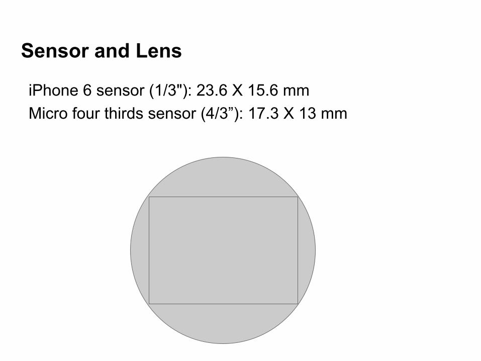
Sensor and Lens
iPhone 6 sensor (1/3"): 23.6 X 15.6 mmMicro four thirds sensor (4/3”): 17.3 X 13 mm