africa - unep/grid-sioux falls · pdf filedivision of early warning and assessment (dewa)....
TRANSCRIPT

i
AFRICAWATER ATLAS

ii
© 2010, United Nations Environment ProgrammeISBN: 978-92-807-3110-1Job Number: DEW/1313/NAThis publication may be reproduced in whole or in part and in any form for educational or non-profi t purposes without special permission from the copyright holder, provided acknowledgement of the source is made. UNEP and the authors would appreciate receiving a copy of any publication that uses this report as a source.
No use of this publication may be made for resale or for any other commercial purpose whatsoever without prior permission in writing from the United Nations Environment Programme.
United Nations Environment ProgrammePO Box 30552, Nairobi 00100, KenyaTel: +254 20 7621234Fax: +254 20 7623943/44http://www.unep.org
United Nations Environment ProgrammeDivision of Early Warning and Assessment-North America47914 252nd Street, United States Geological Survey (USGS) Earth Resources Observation and Science (EROS) CenterSioux Falls, SD 57198-0001 USATel: 1-605-594-6117Fax: [email protected]
For bibliographic and reference purposes this publication should be referred to as:
UNEP. (2010). “Africa Water Atlas”. Division of Early Warning and Assessment (DEWA).United Nations Environment Programme (UNEP). Nairobi, Kenya.
This publication was produced in cooperation with African Union Commission, Africa Ministers’ Council On Water, United Nations Environment Programme, European Union, U.S. Department of State and United States Geological Survey.
This book is available from Earthprint.com, http://www.earthprint.com.Printed by Progress Press Limited, MaltaDistribution by SMI London
DISCLAIMERThe views expressed in this publication are not necessarily those of the agencies cooperating in this project. The designations employed and the presentations do not imply the expression of any opinion whatsoever on the part of UNEP or cooperating agencies concerning the legal status of any country, territory, city, or area of its authorities, or the delineation of its frontiers or boundaries.
Mention of a commercial company or product in this report does not imply endorsement by the United Nations Environment Programme. The use of information from this publication concerning proprietary products for publicity or advertising is not permitted. Trademark names and symbols are used in an editorial fashion with no intention of infringement on trademark or copyright laws.
We regret any errors or omissions that may have been unwittingly made.
UNEP promotes
environmentally sound practices
globally and in its own activities. This publication
is printed on 100 per cent chlorine free paper from
sustainably managed forests. Our distribution policy aims
to reduce UNEP’s carbon footprint.

iii
Table of Contents Foreword ...................................................................................................................................................................................v
Preface and Statements ..................................................................................................................................................... vii
Executive Summary ................................................................................................................................................................x
SPECIAL FEATURE: Water “Hotspots” to “Hopespots”, and Water Towers of Africa ........................................ 2
CHAPTER 1: WATER RESOURCES ..............................................................................................................................................12
Water Availability ................................................................................................................................................................14
Water Distribution ..............................................................................................................................................................14
Surface and Groundwater Resources ..........................................................................................................................19
Water and the Physical Environment ..........................................................................................................................25
Water and Population .......................................................................................................................................................28
Water and Poverty ..............................................................................................................................................................30
Water and Gender ..............................................................................................................................................................31
Water and Transport ..........................................................................................................................................................32
Water and Agriculture ......................................................................................................................................................33
CHAPTER 2: TRANSBOUNDARY WATER RESOURCES .....................................................................................................36
Transboundary Surface Water Basins ..........................................................................................................................38
Congo River Basin ...................................................................................................................................................40
Juba Shabelle Basin ................................................................................................................................................44
Lake Chad Basin .......................................................................................................................................................46
Lake Turkana Basin ..................................................................................................................................................54
Limpopo River Basin...............................................................................................................................................58
Niger River Basin ......................................................................................................................................................60
Nile River Basin .........................................................................................................................................................70
Ogooue River Basin ................................................................................................................................................86
Okavango Delta Makgadikgadi Basin ..............................................................................................................88
Orange River Basin ..................................................................................................................................................90
Senegal River Basin .................................................................................................................................................92
Volta River Basin.......................................................................................................................................................98
Zambezi River Basin ............................................................................................................................................ 100
Transboundary Aquifers ............................................................................................................................................... 106
Nubian Sandstone Aquifer ................................................................................................................................ 109
The North-Western Sahara Aquifer System ................................................................................................ 115
Iullemeden-Irhazer Groundwater Basin ....................................................................................................... 116
The Kalahari Karoo Aquifer ............................................................................................................................... 117
Tano Basin-Abidjan Aquifer .............................................................................................................................. 119
CHAPTER 3: WATER CHALLENGES AND OPPORTUNITIES ........................................................................................ 122
Provide Safe Drinking Water ........................................................................................................................................ 125
Ensure Access to Adequate Sanitation .................................................................................................................... 129
Foster Cooperation in Transboundary Water Basins ........................................................................................... 133
Provide Water for Food Security ................................................................................................................................ 137
Develop Hydropower to Enhance Energy Security ............................................................................................ 143
Meet Growing Water Demand .................................................................................................................................... 151
Prevent Land Degradation and Water Pollution .................................................................................................. 155
Manage Water under Global Climate Change ...................................................................................................... 161
Enhance Capacity to Address Water Challenges.................................................................................................. 169
CHAPTER 4: WATER PROFILE OF COUNTRIES .................................................................................................................. 174
Tracking Progress Towards Environmental Sustainability ................................................................................ 175
Northern Africa ................................................................................................................................................................ 187
Eastern Africa .................................................................................................................................................................... 201
Central Africa..................................................................................................................................................................... 219
Western Africa .................................................................................................................................................................. 237
Southern Africa ................................................................................................................................................................ 271
Western Indian Ocean Islands .................................................................................................................................... 295
Acronyms ............................................................................................................................................................................ 308
Glossary ............................................................................................................................................................................... 309
Acknowledgements.......................................................................................................................................................... 311
Index ..................................................................................................................................................................................... 312

iv
Bru
ce P
en
gra
/UN
EP
iv

v
Foreword
The Millennium Declaration was our boldest political
commitment as heads of state and governments
to provide focused leadership and champion good
governance to eliminate illiteracy, poverty, disease and
environmental degradation by 2015. The Declaration was
a pro-poor statement that was subsequently encapsulated
into eight Millennium Development Goals (MDGs), setting
specifi c targets negotiated at high-level meetings.
It has been ten years since the Millennium
Declaration and as this Atlas makes evident, signifi cant
progress has been made in the water sector in Africa, but
a lot more remains to be done. It also shows that although
there has been important cross-border and sub-regional
dialogue and cooperation, a dearth of scientifi c data and
information impedes eff orts to manage water issues
better. Therefore, this Africa Water Atlas has been wisely
and skilfully packaged to trigger continuous debate and
dialogue to defi ne an agenda for discussions and strategy
planning among ordinary citizens and between water
experts within countries and across national borders.
My own country, Liberia, is not dissimilar to many
African countries that continue to face challenges in
meeting the MDG targets on water and sanitation. At
the 64th Session of the UN General Assembly, the
Secretary General Ban Ki-Moon noted that “It is clear
that improvements in the lives of the poor have been
unacceptably slow, and some hard-won gains are being
eroded by the climate, food and economic crises.”
Whereas, on average, the world will meet the MDG water
targets by 2015, Africa will not, and the eff ects of climate
change exacerbate the situation of water scarcity.
Only 26 countries in Africa are expected to halve the
proportion of their citizens without access to improved
water by the targeted deadline. It is reliably estimated that
in view of increasing population growth and the spiralling
cycle of poverty, new models must be developed if the
MDG targets on water are to be met by 2015. These
estimates show that continental coverage needs to
increase from 64 per cent in 2006 to 78 per cent by
that date.
The sanitation situation is yet another challenge
that needs our special focus as political leaders: only nine
countries in Africa will meet the MDG sanitation target. It
is heartbreaking and unacceptable that only half of Africa’s
population use improved sanitation facilities and that one
in four has no such recourse. Because of such unsanitary
conditions, globally more children under the age of
fi ve die of diarrhoea than of AIDS, measles and malaria
combined. Investing in safe toilet facilities, clean drinking
water supplies and raising awareness of hygiene practices
could protect vulnerable populations from these deaths.
The commitment of some African nations to
allocating 0.5 per cent of their GDP to sanitation under the
e-Thekwini Declaration is an encouraging step forward.
In Liberia, just 17 per cent of the population has access
to proper sanitation, but increased budgetary allocation
by governments to the water and sanitation sector last
year alone has reduced child mortality. To meet the MDG
sanitation target of halving the proportion of people
without sustainable access to basic sanitation, coverage
in Africa needs to increase from 38 per cent in 2006 to 67
per cent in 2015.
This Africa Water Atlas vividly illustrates the
importance of Africa’s water resources in supplying
millions of people with life-giving water and in supporting
activities that are crucial to our ecosystems and
economies. I encourage every leader and policy maker
in Africa to open these pages, and not only marvel at the
images, but take stock of important messages it has to
off er that will help Africa move faster towards the MDG
water targets and secure a better future for our children
and generations to come.
H.E. President Ellen Johnson Sirleaf
Republic of Liberia

vivi
Algiers
Rabat
Tunis
Tripoli
Cairo
Asmara
Khartoum
Djibouti
Addis Ababa
MogadishuKampala
Nairobi
Kigali
Bujumbura
Dodoma
Moroni
Lusaka
Lilongwe
Harare
Gaborone
PretoriaMaputo
Mbabane
Maseru
Windhoek
Luanda
Kinshasa
Bangui
Brazzavile
Sao TomeLibreville
MalaboYaounde
Abuja
Porto Novo
LomeAccra
Yamoussoukro
Monrovia
Freetown
Bissau
Conakry
Banjul
DakarPraia
Nouakchott
Niamey
OuagadougouNdjamena
Antananarivo
Port Louis
Victoria
Bamako
MALICHAD
NIGER
ANGOLA
ETHIOPIANIGERIA
SOUTH
AFRICA
NAMIBIA
MAURITANIA
TANZANIA
ZAMBIA
KENYA
SOMALIA
MOZAMBIQUE
BOTSWANA
CAMEROON
ZIMBABWE
GABON
GHANA
GUINEA
UGANDA
CENTRAL AFRICAN REPUBLIC
SENEGAL
DEMOCRATIC
REPUBLIC
OF
THE CONGO
MADAGASCAR
CÔTE D'IVOIRE
BURKINA FASOBENIN
REPUBLIC OFTHE CONGO
WESTERNSAHARA
MALAWI
LIBERIA
TOGO
SIERRA LEONE
LESOTHO
BURUNDI
RWANDA
DJIBOUTI
GUINEA-BISSAU
SWAZILAND
GAMBIA
EQUATORIALGUINEA
COMOROS
CAPE VERDE
SAO TOME AND PRINCIPE
ALGERIA
MOROCCO
TUNISIA
LIBYA
EGYPT
SUDAN
ERITREA
SEYCHELLES
MAURITIUS
\
\
\

vii
Hon. Buyelwa Patience Sonjica
Chairperson of AMCOW and Minister for Water and
Environmental Aff airs, Republic of South Africa
Preface
Since Africa’s water resources are so vital to basic
livelihoods and economic growth on the continent, an
improved understanding of its availability, distribution
and limitations is crucial for its better management.
Sustainable small-scale and large-scale agriculture,
commercial and artisanal fi sheries, livestock keeping
and range management, industrial growth, hydropower
development and biodiversity all depend on water and
the better management of this resource.
One of the most striking lessons this Africa Water
Atlas brings to light is that water resources are plentiful
in many African countries. However, one of the untold
development ironies and tragedies facing the continent
is that too many people don’t have access to safe drinking
water, and many more lack adequate sanitation facilities.
The Atlas reveals the challenges of moving towards the
water-provision targets, but also highlights solutions to
better manage water and sanitation services that could
help achieve them.
Reasons for this disparity in distribution are
geographical—topographic elevations and proximity
to the Equator cause seasonal variations, for example.
These features create climatic variability that is sometimes
exacerbated by cycles of fl oods and drought events.
Notwithstanding, there are signifi cant political and
economic factors that infl uence availability and access to
water resources. The situation of water scarcity is not made
any better by the infl ux of people to burgeoning cities
and slums as they escape from rural environments that
are increasingly becoming economically unsustainable.
Water stress due to such variability in access has damaged
water resources, prevented their development or sparked
confl icts between neighbours over shared water.
This Africa Water Atlas provides a reference for
our political leaders to work together to develop and
implement policies and laws that will protect Africa’s
water resources, especially by applying Integrated Water
Resources Management (IWRM) to better manage water
basins and sub-basins. IWRM is a useful strategy in dealing
with waters that fl ow over political boundaries and in
managing watersheds and drainage basins shared by two
or more countries.
A special feature section of the Atlas gives optimism
for addressing water concerns: it shows that although
the presence of “hotspots” where rain-fed agriculture is
constrained and food security is tenuous is a formidable
challenge, Africa has many “hopespots” where long-
practiced water-harvesting strategies that have been
used as “coping mechanisms” can be expanded and new
practices adopted, especially in light of the changing
climate. Africa needs to be resilient to develop and spread
these promising tools.
It is my pleasure and privilege to be the President of
AMCOW when this vital document is released. It is also my
hope that its contents will provoke ongoing and fruitful
discussions in our classrooms, villages, conference halls
and national Parliaments on how best we can manage our
African water resources and achieve our sanitation targets
for the benefi t of all.

viii
Mr. Achim Steiner
Executive Director of UNEP
Statement from Mr. Achim Steiner
UN Under-Secretary General and Executive Director UNEP
The seventh Millennium Development Goal (MDG
No. 7) is to Ensure Environmental Sustainability. Its
success is measured by targets for achieving sustainable
development, reversing the loss of environmental
resources, accessing safe drinking water and sanitation
and signifi cantly improving the lives of at least 100 million
slum dwellers by 2015.
The debate that anchored MDG No. 7 climaxed
during the RIO+10 World Summit on Sustainable
Development (WSSD) in 2002 in South Africa. It
was during this meeting, focused on “Equitable and
sustainable use and the protection of the world’s
freshwater resources as a key challenge”, that President
Nelson Mandela underscored “the centrality of water in
the social, political and economic aff airs of a country,
the continent, and indeed the world”. It was also at
this event that Secretary General Kofi Annan’s keynote
address anchored water in its relevance to energy, health,
agriculture and biodiversity.
Africa is often characterized as a dry and arid
continent where rainfall fundamentally limits water
supplies. This pioneering Atlas and its continental and
countrywide assessments challenge this widely-held view.
Indeed, as is the case with energy, the problem is rather a
question of access. Water resources can be more equitably
shared if supplies are better managed for quality and
quantity and more and smarter investments are made
in sanitation, potable water and protecting ecosystem
services that are the very foundation of water resources.
This Africa Water Atlas, the product of the Africa
Ministers Council on Water (AMCOW), points to a suite of
opportunities that off er a way from a situation of water
scarcity to the implementation of strategies that can
contribute to sustainable development and improve the
likelihood of meeting the MDGs. Rainwater harvesting,
for example, is one rapid way to improve water storage in
rural as well as urban areas.
In Ethiopia, for example, just over a fi fth of the
population has access to domestic water supplies and an
estimated 46 per cent of the population suff ers from food
insecurity. On the other hand, its rainwater harvesting
potential could provide for the needs of over 520 million
people. Evidence elsewhere shows that investing in
forests can also generate signifi cant returns, including
maintaining and enhancing water supplies.
A recent assessment by the Government of Kenya,
with assistance from UNEP, illustrates the value of
protecting the forests that help to store water: it estimates
that the ecosystem services provided by the Mau forest
complex may be worth around US$1.5 billion a year. The
Mau Forest Ecosystem, like many other water towers
in Africa, provide services that include stabilizing soils,
storing carbon and regulating water fl ows to some 12
major rivers that feed many lakes in the Great Rift Valley
of Africa. These rivers and lakes supply drinking water, are
harnessed for hydropower and engineered for irrigation
and other key services that contribute to the economy and
human well-being.
Rethinking agriculture and irrigation is also among
Africa’s water-related challenges. A recent survey of small-
scale farmers in Africa who have switched to organic or
near-organic practices found that yields rose by around
100 per cent—in part because of organic matter that
improves soil moisture and lengthens the growing season.
The Africa Water Atlas crystallizes the realities and
these myriad opportunities in a way that all readers can
appreciate. Previous UNEP-supported atlases on Africa,
including the Kenya Atlas of Our Changing Environment,
have sparked real and tangible action including eff orts to
rehabilitate the Mau Forest Ecosystem and restore Lake
Faguibine in Mali. I am confi dent that this Africa Water
Atlas has the power to trigger debate and guide initiatives
that will promote regional peace and the sustainable
development of water resources.

ix
At the WaterDome during the 2002 World Summit on
Sustainable Development (WSSD), the text of the MDG
No. 7 was reviewed and modifi ed to strengthen metrics
to monitor progress towards achieving water targets,
incorporating sanitation as an integral part. The clarion
call was to reduce by half the proportion of people without
access to safe drinking water and adequate sanitation by
2015. In answer to this call, fi nancial commitments were
made through political pronouncements, the mood was
carnival, and leaders seized these moments to reassure the
world they were committed to making a diff erence.
The WaterDome at the WSSD provided an
opportunity for stakeholders and investors to enter
into a dialogue on the water agenda. Several initiatives
were announced, including the European Union Water
Initiative that established a working relationship with
the African Ministers Council on Water (AMCOW). Other
partners have since joined the partnership, including the
African Development Bank, the German Development
Cooperation (GTZ) and the Global Water Partnership
(GWP), among others. The United Nations agencies led by
UNEP have played a pivotal role through the UN Water/
Africa Forum.
To give the water agenda the necessary momentum,
the Secretary General constituted the United Nations
Secretary General Advisory Board on Water and Sanitation
(UNSGAB). UNSGAB has been working closely with the
African Water Facility hosted by the African Development
Bank. Many other fora have been created as vehicles to
support the achievement of water and sanitation targets
in Africa.
The debate on water rights and access in Africa is
centuries old. The history of the Nile River as the lifeline of
riparian communities, beginning with the ancient Egyptian
civilization and its modernized agriculture epitomizes the
debate. The Nile underscores the importance of water
resources for national security and community livelihoods.
It is for this reason that treaties have been signed to secure
the river’s regular fl ow from its sources. Similar debates are
commonplace in most of dryland Africa.
Countries like Libya have invested heavily in
harnessing groundwater from the Nubian Sandstone
Aquifer, thereby creating the largest man-made river in
the world. On a smaller scale, water continues to be a
major source of confl ict amongst nomadic and pastoral
communities in Africa. In urban areas, water is not only
scarce for the poor, but costs up to fi ve times more
compared to affl uent neighbourhoods. The Atlas
also covers these issues, illustrating them with case
studies and with the ample use of maps and other
informative graphics.
Water issues in many parts of Africa can be emotive
and politically divisive. Aware of the potential danger of
regional confl ict over shared waters, the African heads of
state and governments provided leadership and mandated
their water ministers to seek dialogue through a pan-
African platform to make the water agenda a unifying
factor for regional cooperation and integration. One of this
Atlas’s important features is a Chapter on transboundary
water basins that points to the issue of shared water as
a catalyst for cooperation among riparian countries. It
also notes that the emergence of transboundary basin
organizations in many of Africa’s large basins may provide
a powerful opportunity to build an enabling environment
as a foundation for cooperation on numerous fronts.
When the President of the Federal Republic of
Nigeria, H.E. Olusegun Obasanjo, launched the African
Ministers Council of Water (AMCOW) on 22 April 2002 in
Abuja, he was well aware of the gravity of the water issue.
To ensure stability, President Obasanjo off ered that Nigeria
take on the role of host to the AMCOW Secretariat. AMCOW
has since evolved, and is now recognised in the African
Union as a Specialised Technical Committee under the
Commissioner for Rural Economy and Agriculture.
As heads of state and governments continue to
engage with high-level panels such as the G7 Summit
and participate in debates that focus on Africa, it is
imperative that the role of the private sector is emphasised
in improving water and sanitation technologies through
investment in research and development on the continent.
The private sector can also invest in infrastructure
development such as electricity, irrigation, industry and
tourism. This Atlas supports such initiatives.
Because many people in Africa still lack access to
potable water and adequate sanitation, one chapter in the
Africa Water Atlas has been devoted to profi les of the water
situation in each of Africa’s 53 countries. This chapter gives
a snapshot of the progress each one is making in achieving
the water-related MDG targets, and reveals that although
Africa has increased access to drinking water sources and
sanitation facilities, general developments are not keeping
up with population growth and economic activity.
This Africa Water Atlas balances the many challenges
Africa faces in dealing with its water problems by stressing
the opportunities to improve access to adequate and
clean water. The Atlas identifi es opportunities that exist
to support exciting innovations, such as revolutionizing
toilets so that all communities are served, promoting a
Green Revolution that is “greener” and more sustainable
than its post-World War II predecessor, investing in small-
scale hydro and fostering the greening of the Sahel.
I wish to encourage all policy makers in Africa,
including diplomats represented at the African Union,
to embrace this Africa Water Atlas as a crucial reference
document for informed decision-making. I also wish to
thank UNEP, USGS, the European Union Commission,
and all other partners who have played a part in the
development of this seminal document that will accelerate
the pace of cooperation and development on the water
front in Africa.
H.E. Jean Ping
Chairperson of the African Union Commission
Statement from H.E. Jean Ping
Chairperson of the African Union Commission

x
Executive SummaryThis Atlas is a visual account of Africa’s endowment and
use of water resources, revealed through 224 maps and
104 satellite images as well as some 500 graphics and
hundreds of compelling photos. However the Atlas is more
than a collection of static maps and images accompanied
by informative facts and fi gures: its visual elements vividly
illustrate a succinct narrative describing and analyzing
Africa’s water issues and exemplifying them through
the judicious use of case studies. It gathers information
about water in Africa and its role in the economy and
development, health, food security, transboundary
cooperation, capacity building and environmental change
into one comprehensive and accessible volume. UNEP
undertook the production of this Atlas at the request of
the African Ministers’ Council on Water (AMCOW) and
in cooperation with the African Union, European Union,
United States State Department, United States Geological
Survey and other collaborators.
The Atlas tells the paradoxical story of a continent
with adequate renewable water resources, but unequal
access because water is either abundant or scarce
depending on the season or the place. Water is the most
crucial element in ensuring livelihoods since more than
40 per cent of Africa’s population lives in arid, semi-arid
and dry sub-humid areas and about 60 per cent live in
rural areas and depend on farming for their livelihoods.
This particular story is complemented by the encouraging
revelation that although rain-fed agriculture is widely
constrained, there are also many dry areas where
long-practiced and new water-harvesting strategies can
be expanded.
The Atlas also tells stories for each of 53 countries,
highlighting the salient water issues each faces and tallying
the progress they have made towards the Millennium
Development Goals’ water-related targets. They underscore
the still highly inadequate access to potable water and
proper sanitation in most countries. These stories are
also complemented by useful information about novel
strategies and tools that could help to overcome obstacles
(from physical, to technical and political) to achieving
these targets.
These examples demonstrate that this Atlas is an
important tool for decisions makers because it provides clues
to address Africa’s most challenging water issues.
Special Feature: Hotspots to hopespots
and water towers
The Atlas’s four chapters are preceded by a Special Feature
that focuses on the often two-sided nature of water issues
in Africa: surplus and scarcity, under-developed and over-
exploited and challenges and opportunities. It makes a
unique contribution to the knowledge of water issues on
the continent by balancing the recognition of “hotspots”
where rain-fed agriculture is highly constrained and food
security is tenuous with the identifi cation of “hope spots”.
These are places where substantial settlements in arid
and semi-arid areas coincide with adequate rainfall for
water harvesting. Here, traditional and new ways to collect
and store water, such as the widespread construction of
small farm ponds, could be expanded to support fragile
livelihoods, especially in light of the probable impacts of
climate change. The Atlas displays the wide distribution
of these hope spots on maps generated using datasets
of rainfall, soil texture, potential evapotranspiration,
topography, landcover and population. Since ninety-fi ve
per cent of sub-Saharan Africa’s farmland relies on rain-fed
agriculture, and agriculture is the single most important
driver of economic growth, improving food security
through these techniques could very broadly improve
human well being in many of Africa’s drylands.
The Feature also draws attention to Africa’s “water
towers”. These are forested uplands in several African
watersheds, including transboundary basins. They store
water and contribute disproportionately to the total
stream fl ow of Africa’s major rivers that supply water for
hydropower, wildlife and tourism, small- and large-scale
agriculture, municipalities, transportation and ecosystem
services. Implementing Integrated Water Resources
Management (IWRM) could help protect these water
towers and sustainably develop their concentrated water
resources, especially when two or more countries share
them and when upstream activities aff ect downstream
water needs.
Chapter 1: Water resources
The fi rst chapter provides the geographical foundations
of water quantity, quality and distribution across Africa’s
diverse regions. From North Africa to the island countries,
it uses various measures to illustrate Africa’s hydrological
characteristics by charting and mapping water resources
at the continental scale. Topics include Africa’s overall
water resources (lakes and impoundments, rivers,
estuaries, wetlands, groundwater and aquifers, etc.), water
distribution across the continent and access to that water,
the physical setting within which water is found and the
climatic conditions that deliver essential rainfall.
After Australia, Africa is the world’s second-driest
continent. With 15 per cent of the global population, it
has only 9 per cent of global renewable water resources.
Water is also unevenly distributed, with Central Africa
holding 50.66 per cent of the continent’s total internal
water and Northern Africa only 2.99 per cent. In addition,
Africa’s climate is highly variable over the seasons. Africa’s
water availability is also constrained by its groundwater
resources, which represent only 15 per cent of total
renewable water resources, but supply about 75 per cent
of its population with most of its drinking water. Thus,
in all regions except central Africa, water availability per
person is under both the African and global averages.
Africa’s annual per capita water availability is lower than
that of all of the world’s other regions except Asia, the most
populous continent.
This chapter is careful to note, however, that
diff erences in water availability and access in African
countries does not simply depend on natural conditions—
they are infl uenced by the number of people using that
water and compounded by increased water demand
because of growing populations, especially in peri-urban
areas and slums (between 2005 and 2010, Africa’s urban
population grew at a rate of 3.4 per cent, or 1.1 per cent
more than the rural population), and due to higher
standards of living in some population segments; weak
city planning and water and sanitation management; a
lack of resources; and competition for available freshwater
between sectors such as industries, municipalities,
agriculture and tourism and often between upstream
and downstream users. The chapter also explores the
relationship between water and poverty. For example,
widespread poverty constrains many communities’
ability to address water issues even when signifi cant
opportunities such as irrigation, rain-water harvesting,
groundwater exploitation or sanitation infrastructure exist.
Finally, it looks at the relationship between water and
gender, noting that the burden of water collection in Africa
falls disproportionately on women and girls, who in some
cases spend as much as 40 per cent of their caloric intake
carrying water.
Chapter 2: Transboundary water resources
Africa’s many borders and its geography pose a challenge
to equitably sharing and developing its water resources.
Chapter two focuses on water at the scale of major
watersheds and groundwater basins that cross national
boundaries. Africa’s 63 international river basins cover
about 64 per cent of the continent’s land area and contain

xi
93 per cent of its total surface water resources. They are also
home to some 77 per cent of the population.
Chapter two provides in-depth profi les of 13 major
transboundary surface-water and 5 shared groundwater
basins, illustrated with satellite images, maps and pictures.
The groundwater basins represent various regions on the
continent, with special emphasis on the Nubian Sandstone
Aquifer System, Africa’s largest aquifer. Satellite images in
time series show striking cases of environmental change
within the basins over the past several decades, including
landscapes in which lake areas have declined dramatically,
dams have created huge artifi cial lakes, deltas are sinking,
saltwater is invading coastal aquifers, transboundary
wetlands are shrinking and irrigated agriculture has created
spherical green oases in deserts. The case studies examine
issues such as water budgets and water quality, irrigation,
transport, fi sheries and agriculture, invasive species,
population growth and development projects including
dams and diversions, among others. They analyse past and
present conditions, the drivers of change, environmental
and social impacts of water development schemes and
aspects of transboundary water management. One of the
chapter’s conclusions is that the need to share water among
riparian nations is often a catalyst for eff ective cooperative
water management, rather than the source of confl ict.
Chapter 3: Water challenges and opportunities
Chapter three examines nine challenges and opportunities
facing Africa as it strives to improve the quantity, quality
and use of its water resources. Each of the nine issues is
presented by discussing the challenge, the situation, the
constraints and the opportunities.
1. The fi rst challenge is to attain the MDG water-
provision target of reducing by half the proportion
of the population without sustainable access to
drinking water by 2015. Africa as a whole will not
reach this target and only 26 of the 53 countries are
on track to attain it. Opportunities to address this
challenge include the targeting of informal and rural
settlements and adopting and expanding simple but
proven technologies such as a water-disinfection
system that already provides drinking water to about
four million people.
2. Improving access to clean water will help achieve
the second challenge, which is to reduce by half the
proportion of the population without sustainable
access to basic sanitation by 2015. Of Africa’s 53
countries, only nine are expected to attain this target.
Opportunities include the potential to encourage
and support simple entrepreneurial solutions and to
embark on a new drive to revolutionize toilets so they
are as desirable as mobile phones.
3. Africa has 63 shared water basins, so it is a challenge
to address potential confl icts over transboundary
water resources. On the other hand, there are already
at least 94 international water agreements in Africa
to cooperatively manage shared waters. There is thus
an opportunity to learn from their successes and to
build on water as a binding factor.
4. Water scarcity challenges Africa’s ability to ensure
food security for its population. Agriculture uses
the most water in Africa and the estimated rate of
agricultural output increase needed to achieve food
security is 3.3 per cent per year. The potential for
meeting this estimate exists, however, since
two-thirds of African countries have developed less
than 20 per cent of their agricultural production
and less than 5 per cent of cultivated area is under
irrigation in all but four countries. There is also the
opportunity to promote a greener more sustainable
version of the Green Revolution, including
investments in simple and inexpensive irrigation
technologies and breeding drought-tolerant
crop varieties.
5. Hydroelectricity supplies 32 per cent of Africa’s
energy, but its electricity use is the lowest in the
world. Africa’s hydropower potential is under-
developed, however, and hydropower development
potential is greater than the entire continent’s
electricity needs. There are opportunities to develop
this untapped resource, but it should be done in
ways that avoid the environmental and human costs
associated with large dams.
6. Africa faces the challenge of providing enough
water for its people in a time of growing demand
and increased scarcity. But Africa is endowed with
large and often under-utilized aquifer resources that
contain excellent quality water and could provide
water security in times of drought. There is also the
opportunity to improve water-use productivity rather
than develop new sources.
7. Land degradation and water pollution reduce water
quality and availability. These challenges could be
addressed by eff orts to maintain vital ecosystem
functions, fostering the greening of the Sahel by
encouraging adaptation to drought and encouraging
adaptive water management strategies.
8. Africa is one of the most vulnerable continents to
climate change and climate variability. Given the
inherent inter-annual rainfall variability, people
in arid and semi-arid lands have a long history of
traditional adaptation mechanisms that could be
reinforced and adjusted to new circumstances. In
addition, there is the opportunity to provide more
and better early warning mechanisms.
9. Africa faces a situation of economic water scarcity,
and current institutional, fi nancial and human
capacities for managing water are lacking. The
opportunities for addressing this challenge include
reforming water institutions, improving public-
private partnerships and expanding the knowledge
base through human capacity building.
Chapter 4: Water profi le of each country
The fi nal chapter is a country-by-country look at water
availability and withdrawals, irrigation and water use by
sector. Two of the most important water issues in each
country are identifi ed and discussed. The country profi les
also summarize progress toward the MDG water targets.
The MDG summaries frequently highlight the diff erence
between water and sanitation provision in urban versus rural
areas. In general, they reveal that the greatest challenges in
attaining the targets are not environmentally deterministic;
rather, they have to do with political unrest and confl icts that
have damaged water and sanitation resources or prevented
their development; the infl ux of people to burgeoning
cities and slums; and a lack of resources to support water-
management capacity, or simply weak management.
The Atlas is a signifi cant and timely contribution that
can inform the implementation of commitments made in
the Africa Water Vision 2025. Among other goals, the Vision
indicates the minimum need to double the area under
irrigation and develop 25 per cent of Africa’s hydropower
potential. Decision makers can also look to the Atlas for
background information and tools to assist in fulfi lling
commitments made in other recent events and declarations.
These include the 2008 Ministerial Conference on Sanitation
at eThekwini, where ministers pledged to adopt national
sanitation and hygiene policies within 12 months and to
ensure these are on track to meet national sanitation goals
and the MDGs by 2015; the organization of the First African
Water Week and Ministerial Declaration in Tunis; the African
Union (AU) Summit’s dedication to water and sanitation in
June 2008 at Sharm El Sheikh; and the Ministerial Meeting
on Water for Agriculture and Energy at Sirte.
xiixii

1
We never know the worth of water till the well is dry.
~Thomas Fuller, Gnomologia, 1732
Joa
chim
Hu
be
r/Fl
ick
r.co
m
1

2222222222222222222222222222222222222222222222222222222222
The title of this special section highlights the often
two-sided nature of water issues in Africa: positive
and negative, scarcity and surplus, over-exploited
and under-developed, challenges and opportunities.
It looks at the challenges and opportunities inherent
in two quintessential African water issues—uneven
spatial distribution of resources and temporal rainfall
variability. The two vignettes present both the
troublesome and hopeful sides of these two issues.
Hotspots to Hopespots
Over 64 per cent of Africa’s population is rural (World
Bank 2008), with much of that number living on
small subsistence farms. Ninety-fi ve per cent of sub-
Saharan Africa’s farmland relies on rain-fed agriculture
(Wani and others 2009), making most people heavily
dependent upon each year’s rainfall pattern. For
smallholder farms, timely and adequate rains are vital
for livelihoods and food security. In some areas, such
as West Africa where 80 per cent of employment is in
the agriculture sector (Barry and others 2008), timely
rainfall is central to the entire economy. However,
Africa experiences remarkable variability in rainfall
at inter-annual, decadal and longer time scales
(Nicholson 1998, Nicholson 2000, Peel and others
2001). This is of particular concern in arid and semi-
arid zones where rain-fed agriculture is marginal.
Hotspots
Researchers have consequently identifi ed Africa as
one of three global “hotspots” for water-constrained,
rain-fed agriculture. They fi nd that people living in
these “hotspot” environments are disproportionately
undernourished and they link it to climate-driven
food insecurity. Most of the 100 million people in
Africa living in these areas of water-constrained, rain-
fed agriculture are found in a band running through
Senegal, Mali, Burkina Faso, Niger, Nigeria, Chad,
Sudan, Ethiopia, Somalia, Kenya, Tanzania, Zambia,
Malawi, Mozambique, Zimbabwe and South Africa
(Rockström and Karlberg 2009). The red hatching
on Figure i shows the areas within Africa’s arid and
semi-arid regions (Trabucco and others 2009) with
populations of 20 persons per km2 or more (ORNL
2008). These are generally the areas in which food
security is most tenuous in Africa.
SPECIAL FEATURE
WATER “HOTSPOTS” TO “HOPESPOTS”, AND WATER TOWERS OF AFRICA
E. M
ue
nch
/ F
lick
r.co
m
2

3
Water Balance
Hydrologists model Africa’s surface water systems
using data sets describing precipitation, temperature,
evapotranspiration, topography, soils and human-
made diversions and impoundments. Recent research
has used satellite data to more accurately quantify
land-surface processes across the African continent,
and in turn, to better estimate vegetation water use.
Combined with climate data, this produces a map
of “evapotranspiration”—an estimate of the sum of
surface evaporation and plant transpiration. This data
layer has been used to more accurately generate a
water balance map (rainfall minus the water lost to
evapotranspiration) as shown in Figure i. This
water-balance data is used to model surface water
and groundwater behaviour, including stream
fl ow and the potential for dams and other forms of
water harvesting.
Figure i: Annual water balance is an estimate of the available runoff after evapotranspiration—water that is potentially available for water harvesting. The red
hatching overlaying the water balance map shows where population density of greater than 20 persons per km2 coincides with areas defi ned as arid or semi-arid

4
Hopespots
One coping strategy in these drought-prone
environments is rainwater harvesting. This can take
many forms—from large-scale dams that provide
regional benefi ts to the simple collection of rainwater
in a barrel to sustain a household garden through
dry periods. For smallholder farms, indigenous
techniques for collecting and storing water or
enhancing soil moisture are already used in many
locations (Barry and others 2008). Expanding these
practices and adopting new techniques could make a
very signifi cant diff erence in agricultural production
and household food security. Constructing small
ponds to collect runoff is an eff ective practice
that has been used in eastern and southern Africa
to reduce the risk of crop failure and increase
production. This water is then available for multiple
uses, such as watering vegetable gardens and
smallholder farm fi elds during water-stressed periods
(Rockström 2000).
Researching where this approach is best suited
could provide a tool for identifying some “hopespots”
where this simple technique can be applied by
many smallholder farms (Senay and Verdin 2004).
Figure ii: Areas of population density greater than 20 persons per km2 that coincide with arid and semi-arid zones are potential hotspots of vulnerability for
water-constrained rain-fed agriculture (red hatch marks). Many of these areas have adequate runoff for fi lling small farm ponds, which can reduce vulnerability
and improve food security (Senay and Verdin 2004)
Lamu District, Kenya—water
harvesting pond
Eu
ge
ne
Ap
ind
i Och
ien
g

555555555555555555555555555555555555555555555555555555555555555555555555555555555555555555555555555555555555555555555555555555555555555555555555555555555555555555555555555555555555555555555555555555555555555555555555555555555555555555555555555555555555555555555555555555555555555555555
Water harvesting pond under construction in Lamu District, Kenya This concrete slab in northeastern Kenya collects rainfall and diverts it into an
underground storage tank for later use
SO
S S
ah
el U
K /
Flic
kr.
com
5
Eu
ge
ne
Ap
ind
i Och
ien
g
Eu
ge
ne
Ap
ind
i Och
ien
g
Using datasets for rainfall, soil texture, potential
evapotranspiration, topography, landcover and
population, researchers have produced a set of maps
identifying these potential areas (Senay and Verdin
2004). Figure ii is a broad picture of areas with high
potential for this type of technique. Places where
these “hopespots” coincide with populated areas in
arid and semi-arid Africa (red crosshatches) might
be starting points for introducing small farm ponds
and other rainwater harvesting techniques that could
make a big diff erence in the lives of rural people.
Because urban areas have less watershed area
per person from which to collect water, there is less
potential for rainwater harvesting (Senay and Verdin
2004). Nevertheless, water collection from urban
watersheds as small as household rooftops can
provide valuable water for maintaining urban and
peri-urban farming and for domestic use (Kahinda
and others 2007, Kabo-Bah and others 2008).
Hope in Action
Many areas in the Greater Horn of Africa are “hotspots
of water-constrained rain-fed agriculture” (Rockström
and others 2009). However, the successful use of
rainwater harvesting in many locations across the
region is already mitigating the risk for farmers
and helping to reduce food insecurity in their
communities (USAID 2009, Barron 2004, Pachpute
and others 2009). There are numerous examples of
successful rainwater harvesting projects in the region,
particularly in Kenya, including the use of small farm
ponds like those already mentioned. Above are some
images from these bright spots of hope.

6
Water Towers of Africa
Mountainous and other elevated areas in several
African watersheds contribute disproportionately to
the total stream fl ow of Africa’s major rivers. These
areas generally receive more rainfall than their lower
surroundings. They also usually lose less water to
evapotranspiration because temperatures are lower.
Downstream areas often benefi t from the abundant
runoff . Rivers such as the Nile, the Niger, the Senegal
and the Orange fl ow from relatively rain-abundant
areas to areas that would otherwise be too arid to
support much life. These important, high-elevation
watersheds have been referred to as “the water towers
of Africa” for the role they play in supplying millions
with life-giving water. The Millennium Ecosystem
Assessment (MA) states that mountains act as water
towers by storing water in glaciers, permafrost,
snow-packs, soil or groundwater (MA 2005).
These “water towers” are sources for many of
Africa’s transboundary rivers. This can mean upstream
communities infl uence the management of life-giving
resources in downstream areas. In many cases, these
“water towers” are within multi-national watersheds.
While this is sometimes a source of tension, it has
seldom led to all-out armed confl ict. In fact, it has
often proven to be an opportunity for cooperation
(Wolf 2007).
Figure iii shows several of Africa’s “water towers.” They were identifi ed by relative elevation (generally 200–800 m above the surrounding area); precipitation above
750 mm; and runoff above 250 mm. They were also selected for the contribution they make to water resources for populations beyond their delineated boundaries

77777777777777777777777777777777777777777777777777777777777777777777777777777777777777777777777777777777777777777777777777777777777777777
Several of Africa’s transboundary basins are already
under the oversight of basin management organizations,
such as the Niger Basin Commission in West Africa.
Organizations such as these are tasked with presenting
their constituent national governments with the
science-based understanding of resources shared within
these major surface water basins. In this way, the “water
towers” concept can complement Integrated Water
Resources Management (IWRM) processes by identifying
important source areas within major watershed basins.
These areas of concentrated resources can then be
protected and sustainably developed to equitably address
food security, economic development and environmental
issues for all stakeholders.
Kenya’s Five Water Towers
The fi ve “water towers” of Kenya—Mount Kenya, the
Aberdare Range, the Mau Forest Complex, Mount Elgon
and the Cherangani Hills—are montane forests and the
country’s fi ve largest forest blocks. They form the upper
catchments of all the main rivers in Kenya (except the
Tsavo River originating in Mt. Kilimanjaro). The “water
towers” are sources of water for irrigation, agriculture,
industrial processes and for all installed hydropower plants,
which produce about 60 per cent of Kenya’s electricity
output. These montane forests are also surrounded by
Kenya’s most densely populated areas, because they
provide enough water for intensive agriculture and urban
settlements (DRSRS and KFWG 2006). The integrity of
these forests aff ects their capacity to mitigate fl oods and
drought, prevent soil erosion, maintain water quality,
increase groundwater infi ltration and infl uence the
micro-climate in and surrounding the forest (GoK 2010).
7
Mau Forest Complex
The Mau Forest Complex, covering over 400 000 ha,
is the largest of the fi ve water towers. It is Kenya’s
largest closed-canopy forest ecosystem and the
single most important water catchment in the Rift
Valley and western Kenya. The Complex forms part
of the upper catchments of all but one of the main
rivers on the west side of the Rift Valley. These rivers
act as arteries carrying the Mau’s waters throughout
western Kenya—from Lake Turkana in the north
to Lake Natron in the south, as well as to Kenya’s
most populous rural areas in the Lake Victoria basin.
These rivers support agriculture, hydropower, urban
water supply, tourism, rural livelihoods and wildlife
habitat throughout much of Kenya. As a part of
the catchment for Lake Victoria and the White Nile,
the Mau Forest is also of international importance,
especially with respect to water quality.
In spite of its national importance, many areas
of the Mau Forest Complex have been deforested
or degraded; much of this damage has taken place
in the past few decades. Degazettement of forest
reserves and continuous widespread encroachment
have led to the destruction of over 100 000 ha of
Ch
rist
ian
La
mb
rect
s /U
NE
P
Figure iv: The fi ve “water towers” of Kenya
Agricultural expansion into the
Mau Forest Complex
Eu
ge
ne
Ap
ind
i Och
ien
g

8
forest since 2000, representing roughly one-quarter
of the Mau Complex’s area (yellow arrows). The
satellite images from 1973 and 2009 capture 36 years
of forest loss in the Mau Complex.
Since the 1970s, Maasai Mau Forest has lost over
8 214 ha of forest within its offi cial boundaries and
another 32 000 ha outside the protected area. The
eastern slopes of the Maasai Mau Forest are a crucial
catchment for the Ewaso Ngiro River, as are the
western slopes for the Mara River. The Mara River is a
lifeline for Kenya’s most famous tourist destination—
the Maasai Mara National Reserve. In 2001 alone,
over half of Eastern Mau Forest Reserve was excised.
The Eastern Mau Forest is the headwaters for the
Njoro River, which drains its eastern slopes into Lake
Nakuru, another of Kenya’s prime tourist attractions.
Also in 2001, one-quarter of the Southwest Mau
Forest Reserve was excised. This forest reserve is the
primary source of the Sondu River, site of the
Sondu-Miriu hydropower plant. It is estimated that
the Mau Forest catchments have the potential to
generate over 500 MW of power or about 40 per cent
Figure v-a: Many areas of Kenya’s Mau Forest Complex had already been converted to agriculture in the 1970s. Farm fi elds show as light and dark patches with
straight edges between the dark-green forest areas

9
of Kenya’s current total generating capacity (GoK
2010). On the western edge of the Southwest Mau,
the Kericho Highlands tea growing area depends on
the montane forest’s moderating infl uence on the
micro-climate. Sale of tea from western Kenya was
valued at roughly US$170 million in 2007 (GoK 2010).
Recognizing the threat that deforestation poses
to these industries and a range of crucial ecosystem
goods and services, the Kenyan government
convened a forum in 2009 to fi nd ways to address
the health of the Mau Forest Complex. A plan to
rehabilitate the forest was proposed, with a budget
of US$81 million. By early 2010, a commitment of
roughly US$10 million had been received from
international donor governments (UNEP 2010). The
Kenyan government’s goal is to rehabilitate the Mau
Forest and secure its watershed functions for Kenya
and its neighbours (GoK 2010). A new understanding
of the Mau Forest as a “water tower” with importance
well beyond its immediate area helped mobilize
resources and precipitated actions that may make
rehabilitation possible.
Figure v-b: By 2009, several additional large forest areas had been converted to agriculture—see areas indicated by the yellow arrows

10
Lesotho Highlands–A Water
Tower in Southern Africa
The cool, wet and misty climate of the Lesotho
Highlands makes them a more productive water
catchment than the surrounding lower elevations
(FAO 2006). Gauteng Province, 250 km to the north, is
South Africa’s largest urban and industrial centre. In
the 1950s, the proximity of these water-rich highlands
to thirsty Gauteng Province inspired the idea of using
the Lesotho Highlands as a “water tower” (LHDA n.d.).
In 1986, a treaty signed by South Africa and
Lesotho initiated the Lesotho Highlands Water
Project. Its design included a total of fi ve dams but
committed the parties to only the fi rst two dams and
related infrastructure (IUCN n.d.) at a cost of over
$US1.4 billion (Matete 2006). Its purpose is to deliver
water to Gauteng Province in the industrial heartland
of South Africa and hydropower and cash to Lesotho
(Matete 2006). In 1997, the 185 m Katse Dam was
completed on the Malibamatso River; the Mohale
Dam, 40 km to the west on the Senqunyane River,
was completed in 2003 (LHDA n.d.). Phase II of the
Figure vi: The Lesotho Highlands Water Project will construct several dams and transfer tunnels to generate power and move water to Gauteng Province, South
Africa. Katse and Mohale Dams have been completed (yellow triangles). The location and projected reservoir footprints for three additional dams—Ntoahae,
Tsoelike and Polihali—are also shown (red triangles)

11
project has been revised in light of a recent feasibility
study, replacing Mashai Dam and associated
infrastructure by the Polihali Dam located just below
the confl uence of the Senqu and Khubelu Rivers,
roughly 35 km east of Katse Dam (Tanner and others
2009). The existing dams, Katse and Mohale, and
associated reservoirs can be seen in the upper-left
third of the satellite image (Figure vi). The extent of
reservoirs for Polihali Dam, Tsoelike Dam (phase III)
and Ntoahae Dam (phase IV) have been estimated
from digital elevation models and are overlain on
the image.
The project has been controversial since
it began, with concerns about the social and
environmental costs. Katse Dam aff ected more
than 20 000 people and Mohale aff ected 7 400,
with impacts including loss of homes, farmland and
communal grazing land (Devitt and Hitchcock 2010).
Among the environmental concerns raised were
impacts on downstream riparian and coastal habitats
(Willemse 2007, IUCN n.d.). Failure to undertake an
environmental fl ow assessment study of the project
until 1997 (after the fi rst phase of construction was
complete) prevented design changes that could have
mitigated downstream environmental impacts
(IUCN n. d.).
The 1991 images (Figures vii and viii) show
parts of the project area before Katse and Mohale
Dams were constructed. The adjacent images from
2010 after both dams had been fi lled, show the area
inundated. The Katse Dam and Muela Hydropower
Facility (not shown), took approximately 1 900 ha of
croplands out of use and the Mohale Dam removed
a further 1 000 ha. The three dams combined
decreased pastureland by 5 000 ha. In addition to
the impact on the immediate area, approximately
150 000 more people are aff ected by reduced stream
fl ow below the dams (Hoover 2001).
Figure vii: Katse Dam site
Figure viii: Mohale Dam site
Fra
nco
is d
e H
alle
ux
/Flic
kr.
com
The Katse dam reservoir

12
1W
ATE
R
RES
OU
RC
ES
Will
iam
Wa
rby/
Flic
kr.
com

13
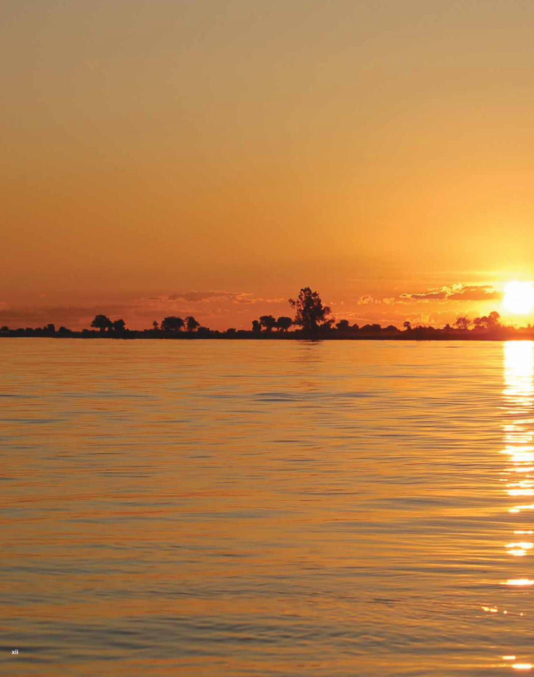
In Africa, the world’s second-driest continent, the availability
and access to water is more crucial to existence than it is almost
anywhere else on Earth. Poverty is widespread and although it is
rapidly urbanizing, the majority of its population is still rural-based
and dependent on agriculture. In sub-Saharan Africa, 69 per cent
of the population has no proper sanitation facilities, while 40
per cent has no reliable access to safe water (WHO/UNICEF 2008).
Thus, a large number of countries on the continent still face huge
challenges in attempting to achieve the United Nations (UN)
water-related Millennium Development Goals. Water plays a central
role in development, covering a broad cross-section of
socio-economic aspects that include meeting people’s basic needs,
such as drinking and sanitation, demands from various economic
sectors, food security, poverty, health, gender issues, governance
issues, energy and transport. Water is indeed everyone’s business,
an essential resource to all aspects of society. In short, water is life.
13
14
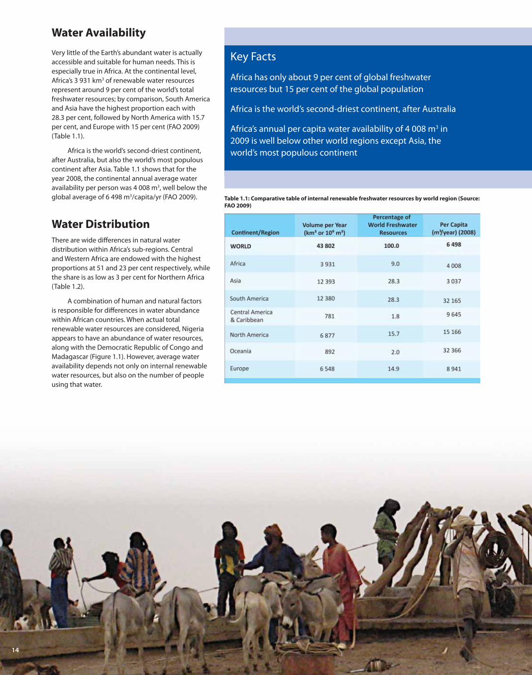
Water Availability
Very little of the Earth’s abundant water is actually
accessible and suitable for human needs. This is
especially true in Africa. At the continental level,
Africa’s 3 931 km3 of renewable water resources
represent around 9 per cent of the world’s total
freshwater resources; by comparison, South America
and Asia have the highest proportion each with
28.3 per cent, followed by North America with 15.7
per cent, and Europe with 15 per cent (FAO 2009)
(Table 1.1).
Africa is the world’s second-driest continent,
after Australia, but also the world’s most populous
continent after Asia. Table 1.1 shows that for the
year 2008, the continental annual average water
availability per person was 4 008 m3, well below the
global average of 6 498 m3/capita/yr (FAO 2009).
Water Distribution
There are wide diff erences in natural water
distribution within Africa’s sub-regions. Central
and Western Africa are endowed with the highest
proportions at 51 and 23 per cent respectively, while
the share is as low as 3 per cent for Northern Africa
(Table 1.2).
A combination of human and natural factors
is responsible for diff erences in water abundance
within African countries. When actual total
renewable water resources are considered, Nigeria
appears to have an abundance of water resources,
along with the Democratic Republic of Congo and
Madagascar (Figure 1.1). However, average water
availability depends not only on internal renewable
water resources, but also on the number of people
using that water.
Key Facts
Africa has only about 9 per cent of global freshwater
resources but 15 per cent of the global population
Africa is the world’s second-driest continent, after Australia
Africa’s annual per capita water availability of 4 008 m3 in
2009 is well below other world regions except Asia, the
world’s most populous continent
Table 1.1: Comparative table of internal renewable freshwater resources by world region (Source:
FAO 2009)
1414414444141414414444114141144441444411114411444441114444111144441411144144414

1511111555555151515115555555111155555115555551111155555511111555555515555555115511115115551155
Key Facts
Renewable water resources are unevenly distributed among
Africa’s sub-regions
A combination of natural and human factors are
responsible for wide diff erences in water availability
between African countries
There are wide variations in average water
availability per person among countries in the
continent (Figure 1.2). For example, the annual per
capita water availability for Nigeria, Africa’s most
populous nation, is lower than that of relatively dry
states such as Botswana and Namibia in Southern
Africa. Annual per capita water availability is high for
countries such as Guinea, Sierra Leone and Liberia
in West Africa; the Democratic Republic of Congo,
Central African Republic and Gabon in Central Africa;
and in the Indian Ocean island of Madagascar. In
the southern part of the continent, water availability
per capita is relatively low for South Africa, as it is in
North African states such as Algeria and Libya, as well
as Kenya in East Africa.
The unequal water distribution has signifi cant
implications for society, often causing widespread
acute human suff ering and economic damage on
a continent where agriculture—largely rain-fed,
is the single most important driver of economic
growth (Conway and others 2009). In addition
to high variability, rainfall across the continent
is unpredictable, and characterized by high
evaporation losses and low runoff (Batisani and
Yarnal 2010, Slimani and others 2010). Groundwater
reservoirs underlain by low-storage geological
formations also depend on eff ective rainfall from
unreliable rainfall patterns for recharging. The
uneven distribution of water resources with respect
to time and population distribution challenges water
supply (UNEP 2002), forcing water managers to
decide between damming the water for distribution
to people, or resettling people closer to water
resources, among other measures.
Rya
n J
am
es
Joh
nso
n
15
Table 1.2: Total and proportional renewable water resources in Africa’s sub-regions (Source:
FAO 2009)

16
Access to Water
Africa’s geography and climate, including periodic
drought and highly variable rainfall, are not the
only—or necessarily the most signifi cant—reasons
for the situations of water scarcity that exist on the
continent. Growing populations and the associated
increased water demand, the costs of providing
water and dwindling water supplies compound the
problem. Water availability is also restricted by a trend
towards urbanization and higher standards of living,
poor or no city planning, a lack of resources and
competition for available freshwater between sectors
such as industry, municipal water and agriculture
and even between nations that share watercourses.
These have resulted in water stress or water scarcity
conditions in the region where the quantity and
quality of water may not be enough to adequately
provide safe drinking water, food and hygiene, may
limit economic development, and can severely
constrain environmental resources (Falkenmark and
others 1989).
These factors mean that people suff er from
a lack of safe drinking water and access to proper
sanitation facilities. The Millennium Development
Goals (MDGs), described in depth in Chapter 4 (which
Key Facts
Millions of people in Africa suff er water shortages throughout
the year
Water scarcity is not simply due to geography: population growth,
rapid urbanization, poor planning and poverty are signifi cant factors
Most urban population growth has taken place in peri-urban slum
neighbourhoods, overwhelming municipal water services
Sixty-four per cent of people in Africa use improved drinking
water sources
Only 38 per cent of Africa’s population has access to improved
sanitation facilities
Increases in access to improved drinking water sources and sanitation
facilities are not keeping pace with population growth
An
dre
w H
eav
en
s/Fl
ick
r.co
mTable 1.3: Defi nition of improved drinking water sources and sanitation facilities (Source: WHO/UNICEF 2008)
a. Bottled water is considered to be improved only when
the household uses water from an improved source for
cooking and personal hygiene; where this information is not
available, bottled water is classifi ed on a case-by-case basis.
b. Shared or public facilities are not considered improved.
c. Excreta are fl ushed into the street, yard or plot, open sewer, a
ditch, a drainage way or other location.

17
Figure 1.1: Total renewable water resources (Source: FAO 2009)
also provides information by country), set out goals
and targets to relieve the most severe poverty in the
world and include targets related to the provision of
safe drinking water and sanitation facilities.
The water-related target is to halve, by 2015,
the proportion of people without sustainable access
to safe drinking water and basic sanitation. Data
gathered to inform the progress nations are making
to meet the MDGs show that in 2006, 341 million
people in Africa lacked access to improved drinking
water sources (WHO/UNICEF 2008) (See Table 1.3
for the defi nitions of “improved” drinking water
and sanitation). Because of population growth, that
number is increasing even though the proportion
of people without such access in Africa as a whole
decreased from 44 per cent in 1990 to 36 per cent in
2006 (WHO/UNICEF 2008). In other words, increases
in coverage are not keeping pace with population
growth. Generally, the drinking water situation is
worse in rural areas than in urban ones: the average
urban drinking water coverage in Africa is 85 per cent
while only 51 per cent of people in rural areas
have access to improved drinking water
(WHO/UNICEF 2008).
Rapid population growth and urbanization,
however, have put enormous pressure on municipal
water sources. Most of the urban population growth
has taken place in peri-urban slum neighbourhoods,
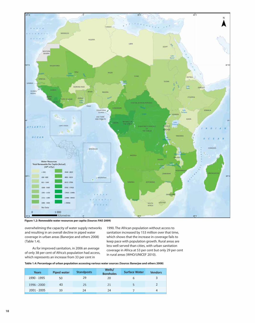
18
Figure 1.2: Renewable water resources per capita (Source: FAO 2009)
overwhelming the capacity of water supply networks
and resulting in an overall decline in piped water
coverage in urban areas (Banerjee and others 2008)
(Table 1.4).
As for improved sanitation, in 2006 an average
of only 38 per cent of Africa’s population had access,
which represents an increase from 33 per cent in
1990. The African population without access to
sanitation increased by 153 million over that time,
which shows that the increase in coverage fails to
keep pace with population growth. Rural areas are
less well served than cities, with urban sanitation
coverage in Africa at 53 per cent but only 29 per cent
in rural areas (WHO/UNICEF 2010).
Table 1.4: Percentage of urban population accessing various water sources (Source: Banerjee and others 2008)

19
Mu
kun
di M
uta
saTable 1.5: Characteristics of Africa’s four major river systems (Sources: UNEP 2000, Hirji and others 2002)
Key Facts
Africa’s largest lakes are Lake Victoria, the world’s second-largest
freshwater lake, and Lake Tanganyika the second-deepest lake in
the world
Some of the world’s largest dams such as Volta, Kariba and Cahora
Bassa are found in Africa
South Africa and Zimbabwe have the most dammed rivers and
among the world’s countries with large dams ranked 11 and 20
respectively
The Lake Chad basin is the largest endoreic basin (an area with
terminal lakes and an interior drainage basin) in the world
Groundwater represents only 15 per cent of Africa’s total
renewable water resources, but about 75 per cent of its population
relies on groundwater as the major drinking
water source
Africa’s important aquifers such as the Nubian Sandstone, the
world’s largest fossil water aquifer system, and the Lake Chad
sedimentary basin, are losing more water than the rate of recharge
Surface and
Groundwater Resources
Rivers
Africa’s water is held in large rivers, widespread
aquifers, large dams, lakes and wetlands as well as
in atmospheric water vapour and soil moisture. The
rivers provide transportation arteries, habitat for
fi sh and other freshwater organisms and water for
drinking and irrigation.
The Nile River is the world’s longest and the
Congo and Niger are within the top 25. Africa’s rivers
have dramatic seasonal variability and inter-annual
variation that refl ects precipitation patterns in those
basins (Walling 1996). For example, the Congo River
has a basin area of 3 669 100 km2, but runoff or
discharge at its mouth is 341 mm, which is more than
twelve times that of the Nile River, whose comparable
basin size covers 3 110 000 km2 (Table 1.5). This
is mainly due to the highly intense rainfall in the
Congo’s catchment area (Hirji and others 2002, SADC
and others 2008). Non-perennial rivers are found
mainly in the arid and semi-arid areas such as the
Sahara and parts of southern Africa.
Lakes
Africa is also home to some of the world’s largest
natural lakes (Table 1.6) and human-constructed
lakes, or dams. In terms of volume, Africa’s natural
lakes and dams have a combined capacity that is
twenty times that of Latin America’s (Wallings 1996).
Although it is relatively shallow, Lake Victoria is the

202022222222222020202202020200200002020200000002222222222220202020000202020220222220202020202020000020202222220202000200202020222000020222020200200000202020200000222222000000002222222000200002222200020002222200200022200000222220222000220022222200002022220000022200000002220002022220000222222000002222222000000222222000000222222000000000002222222222200000000200000022222000000000000222222200000000000002222222220000
Ra
che
l Str
oh
m/F
lick
r.co
m
second-largest freshwater lake in the world, with an
area of approximately 68 600 km2 (Swenson and Wahr
2009). Lake Chad is the shallowest major lake and also
the fourth-largest in Africa in terms of surface area;
it is also the largest wetland in the Sahel region. The
Lake Chad basin, with a surface area of 2 500 000 km2,
is the largest endoreic basin (an area with terminal
lakes and an interior drainage basin) in the world
(LeCoz and others 2009). In the 1960s, Lake Chad was
about 25 000 km2 in surface area, but it experienced
a rapid shrinkage in the early 1970s and has since
been fl uctuating between 2 000 and 15 000 km2,
depending on the season (Lemoalle 2004). The
signifi cant shrinkage experienced since the 1960s
is due to a combination of severe droughts and
irrigation water abstraction (UNEP and WRC 2008).
Lakes Tanganyika and Malawi/Nyasa/Niassa
(Table 1.6) are the world’s second- and third-deepest
lakes respectively, after Lake Baikal in Russia (SADC
and others 2008), with the former holding one per
cent of the total volume of freshwater on the earth’s
surface (Bowen 1982).
Africa’s natural lakes have very diverse origins.
Those along the East African Rift Valley (Lakes Malawi,
Albert, Tanganyika and Turkana) are deep tectonic
lakes; some lakes were formed by volcanic action,
such as Lake Kivu in Rwanda/Democratic Republic
of the Congo. There are also shallow fl oodplain lakes
such as those in the Okavango Swamps. The East
African Rift Valley has many soda lakes and there are
defl ation basins or pans such as those found in the
Kalahari and Panlands of South Africa. In addition,
Africa also has some high altitude lakes of glacial
origin (Walling 1996).
Africa’s lakes support important fi sheries that
sustain millions of livelihoods and contribute to food
security. At the continental level, Africa is second
only to Asia in the global capture of inland fi sh; its
major inland fi shing nations include Uganda, United
Republic of Tanzania, Egypt, Kenya and Democratic
Republic of the Congo (UNEP 2008).
Africa has 63 shared basins covering about
64 per cent of the continental area (UNEP 2005).
Chapter 2 looks at the distinctive features of such
transboundary water resources.
*With low levels 7 000–10 000, with high levels 18 000–25 000 km2.
Table 1.6: Africa’s largest lakes (Source: Shiklomanov and
Rodda 2003)
20

21
Dams
There is about one dam to every 683 000 persons in
Africa, while the equivalent fi gure for the rest of the
world is 168 000 (Strobl, E. and Strobl, R. 2009). More
than 1 270 dams have been built on rivers in Africa
to store water and supply hydropower and irrigation
water (UNEP 2008). Although its large dams are
relatively small compared to the continent’s natural
lakes, a number of African countries have some of the
world’s largest dams (Figure 1.3, Table 1.7).
Figure 1.3: Distribution of dams across Africa
Inte
rna
tio
na
l Riv
ers
Table 1.7: Africa’s largest reservoirs (Source: WCD 1999)

22
Wetlands
According to the Ramsar Convention on Wetlands
(1996), wetlands are areas of marsh, fen, peatland
or water, whether natural or artifi cial, permanent or
temporary, with water that is static or fl owing, fresh,
brackish or salt, including areas of marine water the
depth of which at low tide does not exceed
six metres.
Such areas, which provide many “ecological
goods and services”, including food sources, wildlife
habitat and water storage and fi ltration, cover about
one per cent of the continent’s total surface area and
are found in virtually all countries.
A wide range of wetland types is found in
Africa. Major types include both artifi cial and
anthropogenic lakes, freshwater marshes, river
fl oodplains, swamps and peat lands, in addition to
those containing a mixture of salt and freshwater
such as estuaries and coastal lagoons. Examples of
important wetlands include saline coastal lagoons in
West Africa, freshwater lakes scattered throughout
the continent, brackish-water lakes in East Africa, the
Okavango Delta and Kafue fl ats in Southern Africa,
the marshland along the White Nile in Central Sudan,
and the large fl oodplain wetlands of the savannah
region that fl ow into Lake Chad (Stock 2004, Haller
and Merten 2008, Ramberg and Wolski 200, Etile and
others 2009). Figure 1.4 shows Africa’s main lakes,
rivers and wetlands.
22
Figure 1.4: Surface water showing major natural lakes, rivers and wetlands (Source: UNEP-WCMC 2006)

2322222322323232332332323222222232323232323232323323222222222323232322222223322222232332222222332322222223222222323222333223222232322232222232323233323333333333333333333333322223333
Tim
Pa
rkin
son
/Flic
kr.
com
Estuaries
Estuaries are special types of wetlands
found where rivers such as the Congo,
Zambezi, Nile, Niger and Senegal
discharge into oceans. They normally
have a unique combination of physical
features associated with their shape,
catchment area and connection to
the sea and tidal regime (Khedr 1998).
This interface between saline waters
from the sea and freshwater from rivers
is rich in biological diversity. Lake St
Lucia in South Africa is an example of
an important estuary; it is the largest
estuary on the east coast of Africa and is
recognized as a wetland of international
importance by the Ramsar Convention
(Crook and Mann 2002).
Groundwater
Aquifers and groundwater are highly important in
Africa, especially for dry countries in the northern
and southern sub-regions. Widespread but limited
groundwaters represent only 15 per cent of the
continent’s renewable water resources, but the source
of drinking water for three quarters of the continent’s
population (UNECA and other 2000). The cities of
Lusaka, Windhoek, Kampala, Addis Ababa and Cairo
are highly dependent on groundwater for municipal
water, and groundwater contributes to the supply of
other cities such as Lagos, Abidjan, Cape Town and
Pretoria (Robins and others 2006).
Groundwater plays an important role in
providing water for people and animals in rural areas
Vis
ua
list
Ima
ge
s/Fl
ick
r.co
m
23
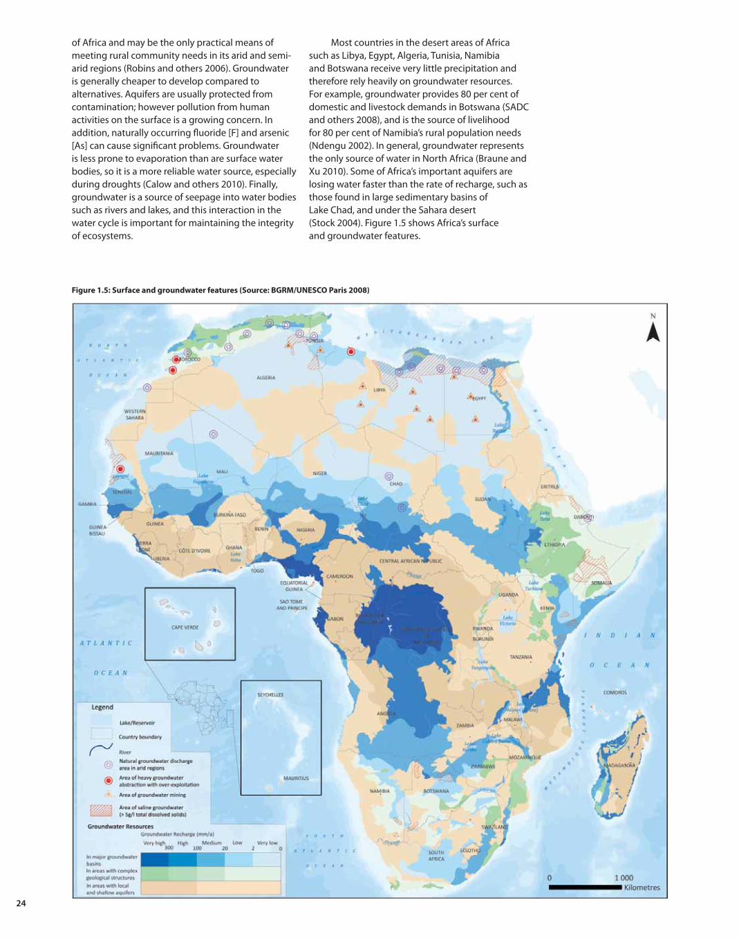
24
Figure 1.5: Surface and groundwater features (Source: BGRM/UNESCO Paris 2008)
of Africa and may be the only practical means of
meeting rural community needs in its arid and semi-
arid regions (Robins and others 2006). Groundwater
is generally cheaper to develop compared to
alternatives. Aquifers are usually protected from
contamination; however pollution from human
activities on the surface is a growing concern. In
addition, naturally occurring fl uoride [F] and arsenic
[As] can cause signifi cant problems. Groundwater
is less prone to evaporation than are surface water
bodies, so it is a more reliable water source, especially
during droughts (Calow and others 2010). Finally,
groundwater is a source of seepage into water bodies
such as rivers and lakes, and this interaction in the
water cycle is important for maintaining the integrity
of ecosystems.
Most countries in the desert areas of Africa
such as Libya, Egypt, Algeria, Tunisia, Namibia
and Botswana receive very little precipitation and
therefore rely heavily on groundwater resources.
For example, groundwater provides 80 per cent of
domestic and livestock demands in Botswana (SADC
and others 2008), and is the source of livelihood
for 80 per cent of Namibia’s rural population needs
(Ndengu 2002). In general, groundwater represents
the only source of water in North Africa (Braune and
Xu 2010). Some of Africa’s important aquifers are
losing water faster than the rate of recharge, such as
those found in large sedimentary basins of
Lake Chad, and under the Sahara desert
(Stock 2004). Figure 1.5 shows Africa’s surface
and groundwater features.

25
Figure 1.6: Rainfall map (Period data collected: 2003–2007, UNEP 2004)
Water and the
Physical Environment
Climate
The distribution of rainfall varies in space and
time, with a consequent overall unreliability of
water supplies. In some places there are temporal
variations as high as 40 per cent around the mean
(UNECA and others 2000). The climate varies from
humid equatorial to seasonally arid and tropical
and sub-tropical Mediterranean-type climates. The
continent’s northern and southernmost extremes
have temperate Mediterranean climates; in between
are the subtropical Sahara and Kalahari deserts.
Rainfall varies considerably by season, with some
regions, such as the drought-prone areas of the
Key Facts
Africa’s climate is characterized by an overall unreliability
of rainfall
There are two rainfall extremes, ranging from near zero in dry
regions such as the Sahara Desert, to extremely high rainfall in
the Congo-Guinean rainforests
There are pronounced seasonal variations in precipitation in
many African regions

26262626262626262626262262626262626262626262626262226262626222622262626222662262626226266226262666262626226226626226266226626226266226266622262666262662266622222266622666226
Sahel, Southern and Eastern Africa, experiencing
pronounced seasonal wet and dry periods (Hulme
and others 2001) (Figure 1.6). Topographical features
and diff erences in sea-surface temperatures infl uence
climatic diff erences between the eastern and western
parts of the continent.
The highest rainfall is observed in the Indian
Ocean Islands and Central African states, while
Northern African states receive the lowest. Overall,
annual rainfall reliability is low, and in most
sub-regions except Central Africa, it is less than
potential evapotranspiration, with a highly variable
picture across Indian Ocean Island States (UNEP and
WRC 2008). Historical records show that during the
20th century, rainfall has been decreasing over large
portions of the Sahel, while rainfall has increased in
East Central Africa (Nicholson 2005).
Major infl uences on the climate come from
prevailing wind movements, which are found in the
equator region, the two tropics and the two largest
deserts: the Sahara in the north, and the Kalahari
in the south-western part. Circulation of these
air masses brings rainfall to diff erent parts of the
continent, and seasonal, inter-annual and long-term
circulation dynamics are instrumental to changes in
local climate zones (Dinar and others 2008).
Figure 1.7: Africa’s Biomes (Source: Chi-Bonnardel 1973)
Ch
rist
ian
La
mb
rech
ts/U
NE
P
26

27
Key Facts
Arid lands cover about 60 per cent of Africa
Precipitation, primary productivity and biodiversity
are correlated
More than 40 per cent of Africa’s population lives in arid,
semi-arid and dry sub-humid areas
Africa’s Biomes
Generally, the pattern of vegetation in Africa largely
mirrors its climatic zones, with areas of high rainfall
producing the greatest volume of biomass, or
primary productivity. On a broad scale, UNEP (2008)
has defi ned the vegetation of Africa in terms of eight
major biomes—large areas with similar patterns of
vegetation, soils, fauna and climate (Figure 1.7).
Approximately 66 per cent of Africa is classifi ed
as arid or semi-arid (Figure 1.8), with extreme
variability in rainfall (UNEP 2002). There are three
main deserts: the Sahara in the north, and the
Kalahari and the Namib deserts in southern Africa.
They are situated around the Tropic of Cancer in
North Africa and the Tropic of Capricorn in the south.
Other arid to semi-arid areas include the belt along
Figure 1.8: Aridity zones (Source: UNEP 2004)

28
Figure 1.9: Comparative population numbers by world region in 2009 and projected population for the year 2050
(Data Source: UNFPA 2009)
Key Facts
Africa’s population growth rate of 2.3 per cent from 2005 to
2010 was the world’s highest
Over that time, Africa’s urban population grew at a rate of
3.4 per cent
Water and Population
Africa’s rising population is one of the main drivers
behind the slow progress in water and sanitation
provision and in the increasing demand for, and
degradation of water resources. Among the world’s
regions, the continent’s average population growth
rate of 2.3 per cent for the period 2005 to 2010 was
the highest (UNFPA 2009). Africa is the second-most
populous continent after Asia (Figure 1.9). Africa also
had the highest urban growth rate for the period
2005-2010, although on average it also had the
largest proportion of rural population in 2009 (UNFPA
2009). About 40 per cent of Africa’s population now
lives in cities. Between 2005 and 2010, Africa’s urban
population grew at a rate of 3.4 per cent, or 1.1
per cent more than the rural population. The urban
growth rate over that time was highest in Central,
Eastern and Western Africa, although at 58 per cent in
2009, Southern Africa had the highest proportion of
urban population (Figure 1.10).
Permanent settlements are sparse in areas such
as the Sahara and the western part of Southern Africa,
but there are some places, such as the Nile delta,
which are densely populated. Unlike biodiversity
and primary productivity, which are generally
correlated to rainfall availability, the distribution of
people in Africa is also infl uenced by many natural
and human induced factors that include availability
of land for agricultural activities, the prevalence of
natural disasters and disease, confl icts over natural
resources, and historical reasons, among others.
Nevertheless, people have tended to settle in areas
of adequate water, and even the emergence of early
civilizations along the Nile River was closely tied to
the eastern coast of Africa, and up to the Horn of
Africa. More than 40 per cent of Africa’s population
lives in the arid, semi-arid, and dry sub-humid areas
where demand for water and other ecosystems
services is on the rise (Ingram and others 2002, De
Rouw 2004, Sultan and others 2005).
Droughts during the past three decades and
land degradation at the desert margins, particularly
the Sahara, have raised concerns about expanding
desertifi cation (Herrmann and Hutchinson 2005). The
full nature of this problem and the degree to which
human activities and climate change are contributing
to it are still being determined. However, the negative
impact that these degraded lands have on the
livelihoods of the people who attempt to utilize them
is well documented (UNEP 2008).

29292292292
Figure 1.10: Selected demographic indicators for African regions (Data source: UNFPA 2009)
the availability of this critical resource. Countries
with high population densities include Nigeria in
West Africa, which is also the most populous nation
on the continent with more than 150 million people
(166 people per km2) and the Central African nations
of Rwanda (394 people per km2) and Burundi (314
people per km2) (World Bank 2010). It is estimated
that the West Africa sub-region will still be the most
populous by the year 2050 (Figure 1.10).
Wo
rld
Ba
nk
Gro
up
29

30
Key Facts
Africa is widely acknowledged as the world’s poorest and least
developed continent
There are signifi cant linkages between water, the environment
and poverty
Water and Poverty
Africa is widely acknowledged as the poorest and
least developed continent in the context of the
following selected issues:
• Nearly half of the entire population of Africa
lives on less than one dollar a day per person
(AfDB 2009);
• Malaria remains the leading cause of child
mortality and anaemia in pregnant women in
Africa, and is endemic in 46 countries
(AfDB 2009);
• The prevalence of undernourishment in the
total population was 25.5 per cent for the period
of 2000-2007 (AfDB 2009), and 30 per cent of
Africa’s children less than fi ve years of age suff er
from moderate to severe malnutrition
(Kolo 2009).
Many of these issues can be linked to Africa’s
water-related problems, which are compounded to
include food shortages, diseases spread by water
and other vectors, and fl ood damage, among other
risks (Van Koppen and Schreiner 2003). Chapter 3
discusses water stress, vulnerability,
physical and economic water scarcity
and the lack of water for food
security in greater depth.
Poverty is a large part of the
reason for low levels of access to
safe water and sanitation, as well
as for lack of other water-related
needs such as irrigation. Poverty is
widespread in Africa and although
it is rapidly urbanizing, the majority
of its population is still rural-based
and dependent on mostly rain-fed
agriculture (as explained in the next
section). Poverty is a cross-sectoral
issue that is normally defi ned in
diff erent contexts. However, it is
widely acknowledged that there
are linkages between water, the
environment and poverty (Faurès
and others 2008, Chowdhury and
Ahmed 2010) (Figure 1.11).
While poverty is a contributing
factor in the widespread lack of
access to improved water sources,
wealth is often linked to the
Figure 1.11: Linkages between poverty, water, and the environment
(Data Source: Hirji and others 2002)
Ne
be
da
ay/F
lick
r.co
m

31313313131313131313131333313131313131131313133313133331
overconsumption of water resources. For example,
a family of eight living in a squatter camp in the
Cape Town area of South Africa uses about 120 litres
of water a day collected from a tap a few hundred
metres away. In contrast, a couple in a nearby rich
neighbourhood who have a big garden to water, can
use 2 000 litres per day (Pallett 1997). Figure 1.11
shows an example of a framework for summarizing
linkages between poverty, water and environment,
where the cross-sectoral nature of poverty is
shown to cover aspects well beyond income and
consumption. The diff erent dimensions of poverty are
shown in the triangles, and examples of water and
environmental linkages are shown in the semi circles.
Water and Gender
Economically and socially vulnerable groups such as
women, the elderly and children often experience
considerable negative eff ects related to the natural
environment, such as droughts and fl oods, and
demographic-related factors that include high
population densities and land degradation (Saleth and others 2007). The issue most directly related to
gender and water is the fact that traditionally, women
and young children, especially girls, are instrumental
in providing water for their families, particularly in
rural Africa. They are thus more adversely aff ected
when there is limited access to water resources.
They often fetch and carry water in containers from
long distances, spending large amounts of time
and energy that could otherwise be used for other
productive tasks. Women often perform between 65
and 72 per cent of water collection duties (Black and
King 2009, WHO/UNICEF 2008), and some African
women spend as much as 40 per cent of their daily
nutritional intake travelling to collect water (Chenje
2000) (Figure 1.12).
Key Facts
Women and girls are instrumental in providing water for
their families
African women often perform between 65 and 72 per cent of
water collection duties
Figure 1.12: Average water collection responsibilities in
Africa (Data Source: WHO/UNICEF 2008)
Kh
ym5
4/F
lick
r.co
m
31

32
Water and Transport
Rivers serve as channels for transportation.
The quest for cheaper and effi cient methods of
transporting goods has seen governments all over
Africa increasingly recognize the value of inland
waterways in promoting trade between nations, and
for the need to integrate diff erent forms of transport
networks across the continent (Ford 2007). Examples
of the current continental impetus to utilize water
transport more include the 20-year rehabilitation
and upgrade plan for ports on Lakes Malawi and
Tanganyika being carried out by the Tanzania Ports
Authority (TPA) to improve the handling of imports
and exports of coal, coff ee, sugar, tea, timber, tobacco
and other commodities through the Tanzanian sea
port of Mtwara on the east coast; and the signing
of a memorandum of understanding to promote
shipping on the Zambezi-Shire water system by the
governments of Zambia, Malawi and Mozambique
(Mzunzu 2002, Ford 2007).
There are extreme navigation problems on most
of Africa’s major rivers (Winkley 1995). There is also
uncoordinated development between diff erent water
use sectors (Toro 1997, Nzewi 2005) and inadequate
funding to develop or make improvements to the
important river navigation systems. Only a few of
the waterways, mainly in the Congo, the Nile and
Zambezi basins, are internationally navigable (UNECA
2009). Navigation issues on the Benue River in West
Africa illustrate some of the challenges associated
with the development of navigation and of Africa’s
water resources in broader terms.
River traffi c on the Benue
River increased steadily from
1945 and peaked around
1964 with a trade volume of
more than 64 000 tonnes of
commodities. Major imports
included cement, fuel, salt and
fertilizer, while cotton fi bre,
other by-products of cotton
and peanuts were the major
exports from the Benue River
Basin countries. Since 1965,
various factors have conspired
to reduce river transport to
almost nothing. Fuel imports
stopped in 1965 and the export
of peanuts ceased in 1966. The
decline has been attributed to a
combination of the
following factors:
(1) Irregular natural
hydrological regimes.
The natural variability of
precipitation has meant that
navigation has never exceeded a
period of sixty days, due to low
river fl ows at certain times.
(2) Environmental pressures. There has been a rapid
and uncontrolled increase in the area of cultivation
adjacent to the river and insuffi cient soil conservation
practices in the Benue River Basin. This has led to soil
erosion and subsequent river siltation, resulting in the
stalling of boats in water too shallow to fl oat vessels.
(3) Internal confl icts. Trade was stopped after the
1967 outbreak of the Biafran War and resumed in
1970 but stagnated to around 15 000 to 20 000
tonnes of commodities per year, mainly meeting the
needs of cotton companies. In 1980, trade declined
again following the outbreak of war in Chad and the
impoundment of the Lagdo Dam.
(4) The emergence of other forms of transport. The
uncertainty and unreliabilty of river transport saw
other forms of transport such as rail and road growing
signifi cantly and gaining a substantial portion of the
market share. However, the loss of vehicles on roads,
problems related to the operation of the railway, and
rising cotton production in both Chad and northern
Cameroon meant that transport problems persisted.
(5) Human management issues. The long-term
management issues of a major link between the
Chad Basin and Benue with the Niger Delta is another
water transport problem.
(6) Dam construction on the Benue River and its
tributaries. In addition to the lowering of water
levels due to silting, the overall hydrology of the
region has also been aff ected by the construction of
the Lagdo Dam on the Benue, the Shiroro Dam on
its tributary in Kaduna and also the Jebba and Kanji
dams on the Niger River.
Source: Enoumba 2010
Case study: Challenges of navigation on the Benue River between Cameroon, Chad and Nigeria
32

33
Water and AgricultureMost economies in Africa are closely tied to natural
resources. Water is directly or indirectly used in
almost every economic sector including agriculture,
manufacturing, trade, mining, tourism, transport, and
telecommunications, among others.
Agriculture—largely rain-fed—is the single
most important driver of economic growth for most
African countries (Webersik and Wilcon 2009) (Figure
1.13). The agricultural sector accounts for about 20
per cent of Africa’s GDP, 60 per cent of its labour force
and 20 per cent of the total merchandise exports, and
is the main source of income for 90 per cent of the
rural population (UNECA 2007). Compared to other
sectors, GDP growth originating in agriculture is about
four times more eff ective in raising incomes of poor
people, with even higher potential multipliers from
investing in agricultural water (World Bank 2009).
Water is both an ecosystem “good”, providing
drinking water, irrigation and hydropower, and an
ecosystem “service”, supplying people, whether they
are aware of it or not, with functions such as cycling
nutrients and supporting habitat for fi sh and other
aquatic organisms, as well as “cultural services” such as
scenic vistas and recreational opportunities.
Table 1.8 provides examples of ecosystem
services that have direct or indirect linkages to
water, classifi ed under four broad categories defi ned
by the Millennium Ecosystem Assessment, 2005:
provisioning, regulating, cultural, and
supporting services.
Key Facts
Agriculture—largely rain-fed—is the main source of income for
90 per cent of the rural population
Compared to other sectors, stimulating economic growth
through agriculture is four times more eff ective in raising
incomes of poor people; investing in agricultural water has even
higher potential multipliers
Figure 1.13: Employment by sector for Africa in 2008
(Data source: ILO 2009, for population: WRI 2009)
Table 1.8 Examples of ecosystem services linked to water (Source: MA 2005)
333333333333333333333333333333333333333333333333333333333333333333333333333333333333333333333333333333333333333333333333333333333333333333333333333333333333333333333333333333333333333333333333333333333333333333333333333333333333333333333333333333333333333333333333333333333333333333333333
IITA
Ima
ge
Lib
rary
/Flic
kr.
com
33

3433333343444433434343344334444444344
ReferencesSpecial Section
Barron, J. (2004). Dry spell mitigation to upgrade semi-arid rainfed agriculture:
Water harvesting and soil nutrient management for smallholder maize
cultivation in Machakos Kenya. Doctoral Thesis – Department of Systems
Ecology, Stockholm University.
Barry, B., Olaleye, A., Zougmoré, R., Fatondji, D. (2008). Rainwater harvesting
technologies in the Sahelian zone of West Africa and the potential for
outscaling. Colombo, Sri Lanka: International Water Management Institute.
(IWMI Working Paper 126)
DRSRS and KFWG. (2006). “Changes in Forest Cover in Kenya’s Five Water Towers,
2003-2005”. Available online at: http://www.unep.org/dewa/assessments/
EcoSystems/Land/mountain/pdf/forest_catchment_2 005_report.pdf (Last
Accessed on September 10, 2010)
Devitt, P. and Hitchcock, R. (2010). Who drives resettlement? The case of Lesotho’s
Mohale Dam. African Study Monographs 31 (2):57-106.
FAO. (2006). Sustainable Rural Development and Food Security: The Role of
Mountain Development in Africa; FAO Regional conference for Africa. Food and
Agriculture Organization of the United Nations. Available online at: http://www.
fao.org/docrep/meeting/004/y6056e.htm#1 (Last Accessed on June 14, 2010)
GoK. (2010). Rehabilitation of the Mau Forest Ecosystem – Programme Document.
Prepared by the Prepared by the Interim Coordinating Secretariat, Offi ce of the
Prime Minister, on behalf of the Government of Kenya, with support from the
United Nations Environment Programme. Governement of Kenya.
Hoover, R. (2001). Pipe Dreams, The World Bank’s Failed Eff orts to Restore Lives and
Livelihoods of Dam-Aff ected People in Lesotho. International Rivers Network.
Available online at: http://www.irn.org/programs/lesotho/pdf/pipedreams.pdf
(Last Accessed on September 27, 2007)
IUCN. (n.d.). The Lesotho Highlands Water Project: environmental fl ow allocations
in an international river. Available online at: http://www.iucn.org/themes/wani/
fl ow/cases/Lesotho.pdf (Last Accessed on September 20, 2007)
Kahinda, J., Taigbenu, A., Boroto, J. (2007). Domestic rainwater harvesting to
improve water supply in rural South Africa. Physics and Chemistry of the Earth
32:1050-1057.
Kabo-Bah, A. Andoh, R., Odai, N. , Osei, K. (2008). Aff ordable Rainwater Harvesting
Systems: A Collaborative Research Eff ort. 11th International conference on
Urban Drainage. Edinburgh, Scotland, 2008. Available online at: http://plc.hydro-
intl.com/index2.php?option=com_docman&task=doc_view&gid=30&Itemid=88
(Last Accessed on August 27, 2010)
LHDA (n.d.). Lesotho Highlands Water Project. Lesotho Highlands Development
Authority. Available online at http://www.lhda.org.ls/news/archive2004/apr04/
inauguration_report.htm (Last Accessed on September 10, 2010)
MA (2005). Ecosystems and Human Well-being: Volume 2 – Current State and
Trends. “Mountain Ecosystems.” Millennium Ecosystem Assessment, Island Press:
Washington D.C.
Matete, M. (2006). The ecological economics of inter-basin water transfers: The
Case of the Lesotho Highlands Water Project. PhD Thesis University of Pretoria.
Available online at: http://upetd.up.ac.za/thesis/available/etd-06052006-
145825/unrestricted/00front.pdf (Accessed September 20, 2007)
Nicholson, S. (1998). Interannual and interdecadal variability of rainfall over the
African continent during the last two centuries. Proceedings of the Abidjan ’98
conference, Abidjan, Côte d’Ivoire, November, 1998. IAHS Publication no. 252,
1998. Available online at: http://iahs.info/redbooks/a252/iahs_252_107.pdf
(Accessed on June 7, 2010)
Nicholson, S. (2000). The nature of rainfall variability over Africa on time scales of
decades to millennia. Global and Planetary Change. 26:137-158.
ORNL. (2008). LandScan Global Population Database 2008. Oak Ridge National
Laboratory. Available online at: http://www.ornl.gov/sci/landscan/index.html
(Last Accessed on June 7, 2010)
Pachpute, J., Tumbo, S., Sally, H., Mul, M. (2009). Sustainability of Rainwater
Harvesting Systems in Rural Catchment of Sub-Saharan Africa. Water Resources
Management 23:2815-2839.
Peel, M., McMahon, T., Finlayson, B., Watson, F. (2001). Indentifi cation and
explanation of continental diff erences in the variability of annual runoff . Journal
of Hydrology. 250:224-240.
Rockström, J. (2000). Water Resources Management in Smallholder Farms in Eastern
and Southern Africa: An Overview. Physics and Chemistry of the Earth (B).
25(3):275-283.
Rockström, J. and Karlberg, L. (2009) Zooming in on the Global Hotspots of
Rainfed Agriculture in Water-constrained Environments. In Rainfed Agriculture:
Unlocking the Potential. Eds. Wani, S.P., Rockström, J. and Oweis, T. (2009)
Rainfed Agriculture Unlocking the Potential. CAB International. Available online
at: http://www.iwmi.cgiar.org/Publications/CABI_Publications/CA_CABI_Series/
Rainfed_Agriculture/Protected/Rainfed_Agriculture_Unlocking_the_Potential.
pdf (Last Accessed on June 7, 2010)
Senay, G. and Verdin, J. (2004) Developing Index Maps of Water-Harvest Potential in
Africa. Applied Engineering in Agriculture 20(6):789-799.
Senay, G., Pengra, B., Bohms, S., Singh, A., Verdin, J. (2010). Africa-wide water
balance estimation using remote sensing and global weather datasets.
American Geophysical Conference Fall Meeting. Submitted.
Tanner, A., Tohlang, S. and Van Niekerk, P. (2009). Civil Engineering – South African
Institution of civil Engineering. 17(5):28-35.
Trabucco, A. and Zomer, R. (2009). Global Aridity Index (Global-Aridity) and
Global Potential Evapo-Transpiration (Global-PET) Geospatial Database. CGIAR
Consortium for Spatial Information. Published online, available from the CGIAR-
CSI GeoPortal at: http://www.csi.cgiar.org. (Last Accessed on June 7, 2010)
UNEP (2010) Multimillion Dollar Response to Mau Appeal Brings Restoration Hope
to Kenya and the Region Accessed August 13, 2010 at: http://www.unep.org/
Documents.Multilingual/Default.asp?ArticleID=6549&DocumentID=624&l=en
USAID. (2009). Success Story: Defending Against Drought in Kenya. Available
online at: http://www.usaid.gov/our_work/humanitarian_assistance/disaster_
assistance/countries/kenya/template/fi les/Success_Story_123009.pdf (Accessed
June 23, 2010)
Wani, S., Sreedevi, T., Rockström, J. and Ramakrishna, R. (2009). Rainfed Agriculture
– Past Trends and Future Prospects. In Rainfed Agriculture: Unlocking the
Potential. Eds. Wani, S.P., Rockström, J., Oweis, T. (2009). Rainfed Agriculture
Unlocking the Potential. CAB International. Available online at: http://www.iwmi.
cgiar.org/Publications/CABI_Publications/CA_CABI_Series/Rainfed_Agriculture/
Protected/Rainfed_Agriculture_Unlocking_the_Potential.pdf (Last Accessed on
June 7, 2010)
Willemse, N. E. (2007). Actual versus Predicted Transboundary Impact: A Case
Study of Phase 1B of the Lesotho Highlands Water Project. Water Resources
Development 23 (3):457-472.
Wolf, A. (2007) Shared Waters: Confl ict and Cooperation. Annual Review of
Environmental Resources 32:241-269.
Chapter1
AfDB. (2009). “Gender, Poverty and Environmental Indicators on African Countries.”
Economic and Social
Statistics Division Statistics Department, ADB: Tunis. African Development Bank.
http://www.afdb.org/fi leadmin/uploads/afdb/Documents/Publications/
GenderPovertyE nvironmental_IndicatorsAfricanCountries2009_01_Full_Report.
pdf (Last accessed on February 23, 2009).
Banerjee, S., Skilling, H., Foster, V., Briceño-Garmendia, C., Morella, E., Chfadi, T.
(2008). “Africa Infrastructure
Country Diagnostic: Urban Water Supply Africa”. World Bank and the Water and
Sanitation Program. http://www.eu-africa-infrastructuretf.net/attachments/
library/aicd-backgroundpaper-12-water-summary-en.pdf (Last accessed on
June 23, 2010).
Batisani, N. and Yarnal, B. (2010). Rainfall Variability and Trends in Semi-Arid
Botswana: Implications for Climate Change Adaptation Policy. Applied
Geography In Press, Corrected Proof.
BGRM /UNESCO Paris (2008). World-wide Hydrogeological Mapping and
Assessment Programme (WHYMAP). http://www.whymap.org/cln_145/
whymap/EN/Home/whymap_nodehtml?__nnn=true (Last accessed on June
20, 2010).
Black, M., and J. King. (2009). The Atlas of Water: Mapping the World’s Most Critical
Resource. University of California Press.
Bowen, R. (1982). Surface Water. Applied Science Publishers: London.
Braune, E. and Xu, Y. (2010). The Role of Ground Water in Sub-Saharan Africa.
Ground Water, 48: 229–238. doi: 10.1111/j.1745-6584.2009.00557.x.
Calow, R., MacDonald, A., Nicol, A., Robins, N. (2010). Ground Water Security and
Drought in Africa: Linking Availability, Access, and Demand. Ground Water. 48:
2, 246–256. http://onlinelibrary.wiley.com/doi/10.1111/j.1745-6584.2009.00558.
xpdf (Last accessed on August 17, 2010).
Chenje, M. (2000). State of the Environment in the Zambezi Basin 2000. Southern
African Research & Documentation Centre, Zimbabwe.
Chi-Bonnardel, Regine Van. (1973). Atlas of Africa. Institut geographique national
(France). Paris: Editions Jeune Afrique, pp.335.
Chowdhury, M. and Ahmed, S. (2010). Poverty-environment nexus: an investigation
of linkage using survey data. International Journal of Environment and
Sustainable Development. 9(1-3): 91-113.
Conway, D., Persechino, A., Ardoin-Bardin, S., Hamandawana, H., Dieulin, C., Mahé,
G. (2009). Rainfall and water resources variability in Sub-Saharan Africa during
the Twentieth Century. Journal of Hydrometeorology 10(1): 41-59.
Crook, B., and Mann, B. (2002). A critique of and recommendations for a subsistence
fi shery, Lake St Lucia, South Africa. Biodiversity and Conservation 11: 1223-1235.
De Rouw, A. (2004). Improving yields and reducing risks in pearl millet farming in
the African Sahel. Agricultural Systems. 81: 73-93.
Dinar, A., Hassan, R., Mendelsohn, R., Benhin, J. (2008). Climate change and
agriculture in Africa: Impact assessment and adaptation strategies. Earthscan:
London; VA.
Enoumba, H. (2010). Challenges of navigation on the Benue River between
Cameroon, Chad and Nigeria. Unpublished.
Etile, R., Kouassi, A., Aka, M. , Pagano, M., N’Douba, V., Kouassi, N. (2009). Spatio-
temporal variations of the zooplankton abundance and composition in a West
African tropical coastal lagoon (Grand-Lahou, Côte d’Ivoire). Hydrobiologia.
624:171-189. DOI 10.1007/s10750-008-9691-7.
34

3535353333535353535335
FAO. (2009). AQUASTAT database. Food and Agriculture Organization of the United
Nations. http://www.fao.org/nr/aquastat (Last accessed on May 11, 2010).
Falkenmark, M., Lundqvist, J., Widstrand, C. (1989). Macro- scale water scarcity
requires micro- scale approaches: Aspects of vulnerability in semi- arid
development, Nat. Resour. Forum, 13, 258–267.
Faurès, J., Santini, G., Nepveu de Villemarceau, A. (2008). A livelihood approach to
water interventions in rural areas and implications for Multiple Use Systems’
in Multiple-use Water Services (Eds. J, Butterworth, M. Keitjizer, I. Smout and F.
Hagos) Proceedings of an international symposium held in Addis Ababa,
Ethiopia, 4-6 November 2008. MUSGroup.
Ford, N. (2007). East African waterways off er cheap and easy transport. African
Business 01413929, Aug/Sep2007, Issue 334.
Haller, T. and Merten, S. (2008). We are Zambians-Don’t Tell Us How to Fish.
Institutional Change, Power Relations and Confl icts in the Kafue Flats Fisheries in
Zambia. Human Ecology. 36: 699-715.
Herrmann, S., and Hutchinson, C. (2005). The changing contexts of the
desertifi cation debate. Journal of Arid Environments, 63, 538-555.
Hirji, R., Johnson, P., Maro, P., Matiza-Chiuta, T. (2002). Defi ning and mainstreaming
environmental sustainability in water resource management in southern Africa.
Washington, DC: World Bank, 2002.
Hulme, M., Doherty, R., Ngara, T., New, M., Lister, D. (2001). African climate change:
1900-2100. Climate Research. 17:145-168.
ILO. (2009). “Global Employment Trends January 2009”. International Labor Offi ce:
Geneva. http://www.ilo.org/wcmsp5/groups/public/---dgreports/--- dcomm/
documents/publication/wcms_101461.pdf (Last accessed on March 5, 2010).
Ingram, K., Roncoli, M., Kirshen, P. (2002). Opportunities and constraints for farmers
of West Africa to use seasonal precipitation forecasts with Burkina Faso as a case
study. Agricultural Systems. 74: 331-349.
Khedr, A. (1998). Vegetation zonation and management in the Damietta estuary of
the River Nile. Journal of Coastal Conservation. 4: 79-86.
Kolo, J. (2009). Striving for results: Prescriptions for broadening the sustainable
development principles for policy making and planning in Africa. Journal of
Sustainable Development in Africa. 11(1): 78-97.
LeCoz, M., Delclaux, F, Genthon, P., Favreau, G. (2009). Assessment of Digital
Elevation Model (DEM) aggregation methods for Hydrological modeling: Lake
Chad basin, Africa. Computers and Geosciences. 35:1661-1670.
Lemoalle, J. (2004). Lake Chad: A changing environment. In: Nihoul, J.C.J., Zavialov,
P.O., Micklin, P.P.(Eds.),Dying and Dead Seas. Kluwer Academic Publishers:
Dordrecht, pp.321-340.
MA. (2005). Ecosystems and Human Well-being: Synthesis. Island Press: Washington,
DC. Millennium Ecosystem Assessment.
Mzunzu, M. (2002). Hydrographic survey Lake Malawi: A bilateral co-operation
(Malawi - Iceland) for safety of navigation on the third largest lake in Africa.
Hydro International. 6 (4): 57-59.
Ndengu, S. (2002). International shared aquifers in Namibia. Proceedings of the
International Workshop Tripoli, Libya, 2- 4 June 2002. http://www.isarm.net/
dynamics/modules/SFIL0100/view.php?fi l_Id=176. (Last accessed on May 10,
2010).
Nicholson, S. (2005). On the question of the “recovery” of the rains in theWest
African Sahel. Journal of Arid Environments. 63:615-641.
Nzewi, E.(2005). Managing water resources systems for sustainable development in
underdeveloped regions. World Water Congress 2005: Impacts of Global Climate
Change - Proceedings of the 2005 World Water and Environmental Resources
Congress, pp. 275.
Pallett, J. (Ed.). (1997). Sharing Water in Southern Africa. Desert Research
Foundation of Namibia. Windhoek.
Ramberg, L. and Wolski, P. (2008). Growing islands and sinking solutes: processes
maintaining the endorheic Okavango Delta as a freshwater system. Plant
Ecology. 196 (2): 215-231.
Robins, N., Davies, J., Farr, J., Calow, R. (2006). The changing role of hydrogeology in
semi-arid southern and eastern Africa. Hydrogeology Journal. 14: 1481-1492.
SADC, SARDC, IUCN, UNEP. (2008). Southern Africa Environment Outlook.
Southern African Development Community. Southern African Research and
Documentation Centre. IUCN-The World Conservation Union. United Nations
Environment Programme. http://soer.deat.gov.za/State_of_the_Environment.
html (Last accessed September 14, 2010)
Saleth, R., Samad, M., Molden, D., Hussain, I. (2003). Water, poverty and gender: An
overview of issues and policies. Water Policy 5: 385-398.
Shiklomanov I. and Rodda, J. (Eds.). (2003). World water resources at the beginning
of the twenty-fi rst century. International Hydrology Series. UNESCO: Cambridge
University Press. 423 pp.
Slimani, H., Aidoud, A., Rozé, F. (2010). 30 Years of Protection and Monitoring of a
Steppic Rangeland Undergoing Desertifi cation. Journal of Arid Environments 74,
no. 6 (2010): 685-91.
Stock, R. .(2004). Africa South of the Sahara: A Geographical Interpretation. Guilford
Press: New York.
Sultan B., Baron C., Dingkuhn M., Sarr B., Janicot S. (2005). Agricultural impacts
of large-scale variability of the West African monsoon. Agricultural and forest
meteorology. 128 (1-2) : 93-110.
Strobl, E. and Strobl, R. (2009). The Distributional impact of dams: Evidence from
cropland productivity in Africa. Working Papers hal-00392381_v1, HAL. http://
halshs.archives-ouvertes.fr/hal-00392381/ (Last accessed on June 20, 2010).
Swenson, S. and Wahr, J. (2009). Monitoring the water balance of Lake Victoria, East
Africa, from space. Journal of Hydrology. 370: 163-176.
The Ramsar Convention on Wetlands. (1996). “ The Ramsar Convention defi nition of
“wetland” and classifi cation system for wetland type”. Available online at http://
www.ramsar.org/cda/en/ramsar-activities-cepaclassifi cation-system/main/
ramsar/1-63-69%5E21235_4000_0__ (Last accessed on June 20, 2010).
Toro, S. (1997). Post-construction eff ects of the Cameroonian Lagdo Dam on the
River Benue. Journal of the Chartered Institution of Water & Environmental
Management. 11(2): 109−113.
UNECA, AU and AfDB. (2000). “The Africa Water Vision for 2025: Equitable and
Sustainable Use of Water for Socioeconomic Development”. Economic
Commission for Africa, African Union and African Development Bank. Addis
Ababa. http://www.uneca.org/awich/African%20Water%20Vision%2025.pdf
(Last accessed on June 20, 2010).
UNECA. (2007). Africa Review Report on Agriculture and Rural Development. United
Nations Economic Commission for Africa. http://www.un.org/esa/sustdev/csd/
csd16/rim/eca_bg2.pdf (last accessed on September 14, 2010).
UNECA. (2009). The transport situation in Africa. Sixth session of the Committee on
Trade, Regional Cooperation and Integration. 13-15 October 2009. Economic
Commission for Africa, Addis Ababa, Ethiopia. http://www.uneca.org/eca_
resources/major_eca_websites/crci/6th/TransportSituationinAfrica.pdf
(Last accessed on February 15, 2009).
UNEP. (2000). Water Sharing in the Nile River Valley. United Nations Environment
Programme (UNEP/DEWA/GRID: Geneva). http://www.grid.unep.ch/activities/
sustainable/nile/nilereport.pdf (Last accessed on February 25, 2010).
UNEP. (2002). Africa Environment Outlook: Past, present and future perspectives.
United Nations Environment Programme. Earthprint: UK.
UNEP. (2004). Annual Precipitation. Climate Research Unit. United Nations
Environment Programme. http://geodata.grid.unep.ch (Last accessed on
September 22, 2010).
UNEP. (2005). Mau Complex Under Siege, Continuous destruction of Kenya’s largest
forest. United Nations Environment Programme, Kenya Wildlife Service and
Kenya Forests Working Group. June 2005.
UNEP. (2008). Africa: Atlas of Our Changing Environment. United Nations
Environment Programme, Nairobi.
UNEP and WRC. (2008). Assessment of transboundary freshwater vulnerability in
Africa to climate change. United Nations Environment Programme and Water
Research Commission. http://www.unep.org/dewa/assessments/ecosystems/
water/Assessment_of_Transboundary_Freshwater_Vulnerability_revised.pdf
(Last accessed on March 3, 2008).
UNEP-WCMC. (2006). Wetlands. United Nations Environment Programme-World
Conservation Monitoring Centre. Available online at http://geodata.grid.unep.
ch/mod_metadata/metadata.php (Last accessed on June 11, 2010).
UNFPA. (2009). State of world population 2009: Facing a changing world: women,
population and climate. United Nations Population Fund. New York: UNFPA.
Walling, D. (1996). Hydrology and Rivers. In: The Physical Geography of Africa
(W.M. Adams, A.S. Goudie and A.R. Orme, Eds.). Oxford, Oxford University Press,
103–121.
WCD. (1999). “Dam Statistics: Africa and the Middle East Regions. http://www.
dams.org/kbase/consultations/afrme/dam_stats_eng.htm (Last accessed on
September 4, 2010).
Webersik, C. and Wilcon, C. (2009). Achieving Environmental Sustainability and
Growth in Africa: the Role of Science, Technology and Innovation. Sustainable
Development, 17, 400-413.
WHO/UNICEF (2008). Progress on Drinking Water and Sanitation Special focus
on Sanitation. Joint Monitoring Programme (JMP). http://www.who.int/
water_sanitation_health/monitoring/jmp2008/en/index.html (Last accessed on
March 2, 2010).
Winkley, B. (1995). Navigation Problems on the Zaire River, Africa. International
Water Resources Engineering Conference – Proceedings. 2: 1754-1758.
World Bank. (2009). Africa’s Infrastructure: A Time for Transformation. World Bank:
Washington, DC.
World Bank. (2010). World development report: Development and climate change.
World Bank: Washington, DC.
WRI. (2009). Population, Health and Human Well-being. World Resources Institute.
http://earthtrends.wri.org/searchable_db/index.php?theme=4 (Last accessed
on September 14, 2010).
Hu
go
va
n T
ilbo
rg/F
lick
r.co
m
35

36
2TR
AN
SBO
UN
DA
RY
W
ATE
R R
ESO
UR
CES
Law
ren
ce M
urr
ay/F
lick
r.co
m