agenda item 9 - tower hamletsdemocracy.towerhamlets.gov.uk/documents/s30637/app 1 - 31st may... ·...
TRANSCRIPT
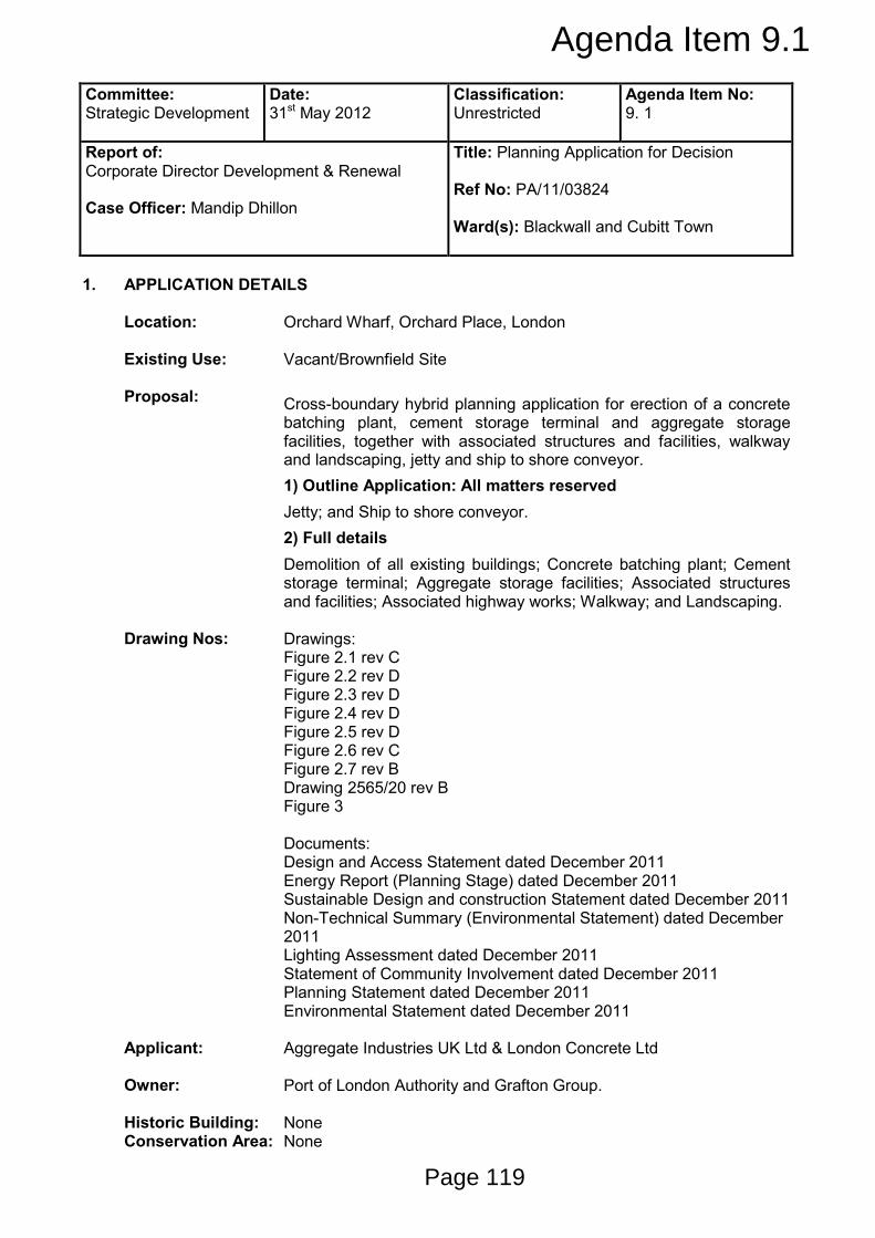
Committee: Strategic Development
Date: 31st May 2012
Classification: Unrestricted
Agenda Item No: 9. 1
Report of: Corporate Director Development & Renewal Case Officer: Mandip Dhillon
Title: Planning Application for Decision Ref No: PA/11/03824 Ward(s): Blackwall and Cubitt Town
1. APPLICATION DETAILS Location: Orchard Wharf, Orchard Place, London
Existing Use: Vacant/Brownfield Site
Proposal: Cross-boundary hybrid planning application for erection of a concrete
batching plant, cement storage terminal and aggregate storage facilities, together with associated structures and facilities, walkway and landscaping, jetty and ship to shore conveyor.
1) Outline Application: All matters reserved
Jetty; and Ship to shore conveyor.
2) Full details
Demolition of all existing buildings; Concrete batching plant; Cement storage terminal; Aggregate storage facilities; Associated structures and facilities; Associated highway works; Walkway; and Landscaping.
Drawing Nos: Drawings: Figure 2.1 rev C Figure 2.2 rev D Figure 2.3 rev D Figure 2.4 rev D Figure 2.5 rev D Figure 2.6 rev C Figure 2.7 rev B Drawing 2565/20 rev B Figure 3 Documents: Design and Access Statement dated December 2011 Energy Report (Planning Stage) dated December 2011 Sustainable Design and construction Statement dated December 2011 Non-Technical Summary (Environmental Statement) dated December 2011 Lighting Assessment dated December 2011 Statement of Community Involvement dated December 2011 Planning Statement dated December 2011 Environmental Statement dated December 2011
Applicant: Aggregate Industries UK Ltd & London Concrete Ltd
Owner: Port of London Authority and Grafton Group.
Historic Building: None Conservation Area: None
Agenda Item 9.1
Page 119
2. SUMMARY OF MATERIAL PLANNING CONSIDERATIONS 2.1 Officers have considered the particular circumstances of this application against the
Council’s approved planning policies contained in the London Borough of Tower Hamlets Unitary Development Plan 1998, (Saved policies); associated Supplementary Planning Guidance, the London Borough of Tower Hamlets adopted Core Strategy (2010), Development Management DPD (Proposed Submission Version 2012); as well as the London Plan (2011) and the National Planning Policy Framework, and has found that:
• In land use terms, the national safeguarding of the application site supports the
principle of re-activating the site for aggregate storage and concrete batching. The proposal therefore accords with policies 7.24, 7.26 and 7.30 of the London Plan 2011, policy SP12 of the Core Strategy 2010 and site allocation LS22 of the Leaside Area Action Plan 2007.
• Given the safeguarded wharf status of the site, the proposed development is considered appropriate in terms of design, bulk and scale and massing. The design and scale of the new building is in keeping with the surrounding properties in terms of general building line and height. This accords with saved policy DEV1 of the Unitary Development Plan 1998; strategic objectives and policies SO20, SO21, SO22, SO23 and SP10 of the Core Strategy 2010, policies DM23 and DM34 of the Managing Development DPD Submission Version May 2012 and DEV2 of the Interim Planning Guidance 2007.
• Given the safeguarded wharf status of the site, the proposals are considered to be acceptable in relation to local views and value of the East India Dock Basin nature reserve and riverfront views into the site. The proposal therefore accords with DEV8 of the Unitary Development Plan 1998, CON5 of the Interim Planning Guidance 2007 and SP10 of the Core Strategy 2010.
• Given the location of the surrounding listed buildings and structures which are not within the immediate vicinity of the site, it is considered that the proposals would not detrimentally impact upon the setting of the adjoining heritage assets. The proposal is considered to be in accordance with policies CON1 and CON2 of the Interim Planning Guidance 2007, SP10 of the Core Strategy 2010 and DM27 of the Managing Development DPD Submission Version May 2012.
• On balance, the buffer zone and noise mitigation measures proposed are considered to provide adequate measures to ensure the amenity of existing and future adjoining occupiers. The proposal is therefore considered to accord with policies 7.14 and 7.15 of the London Plan 2011, saved policies DEV2 and DEV50 of the Unitary Development Plan 1998, policies SP02, SP03 and SP10 of the Core Strategy 2010 and policies DM9 and DM25 of the Managing Development DPD Submission Version May 2012 which seek to ensure that development proposals reduce noise minimising the potential adverse impact on amenity.
• The proposed development, by virtue of its scale, design and massing is not considered to result in the loss of daylight and sunlight surrounding the site. In addition the distance and orientation of the proposed office building is unlikely to cause any loss of privacy to the live work units at Orchard Place or adjoining occupiers. The proposals are considered to accord with policy SP10 of the Core Strategy 2010, saved policy DEV2 of the Unitary Development Plan and policy DM25 of the Managing Development DPD Submission Version May 2012 which seek to protect the amenity of existing a future occupiers.
• On balance, it is considered that the proposed works both on-site and off-site
Page 120

sufficiently seek to protect the biodiversity of the site and enhance the biodiversity of the adjacent East India Dock Basin (EIDB). If all the proposed on-site mitigation and the de-silting of EIDB are carried out successfully, this should result in a net gain in Biodiversity which results in a neutral impact on its recreational amenity value in accordance with the National Planning Policy Framework. The works are therefore considered to accord with policy 7.19 of the London Plan 2011 and policy SP04 of the Core Strategy 2010 and the National Planning Policy Framework.
• Subject to the imposition of conditions, the proposal is considered to reduce the impact and risk of flooding. The proposal therefore accords with policy 5.12 of the London Plan 2011, saved policy U2 of the Unitary Development Plan 1998, policy DEV21 of the Interim Planning Guidance 2007 and policy SP04 of the Core Strategy 2010.
• On balance, it is considered that sustainability matters, including energy are acceptable and accord with policies 5.2 to 5.7 of the London Plan 2011, policy SP11 of the Core Strategy 2010, policy DM29 of the Managing Development DPD Submission Version May 2012 and policies DEV5 to DEV9 of the Interim Planning Guidance 2007, which seek to promote sustainable development practices.
• On balance, transport matters, including parking, access and servicing, are considered acceptable and in line with policies T16 and T19 of the Council’s Unitary Development Plan (1998), policy SP08 and SP09 of the Core Strategy 2010 and DM20 and DM22 of the Managing Development DPD Submission Version May 2012, which seek to ensure developments minimise parking and promote sustainable transport options.
• The proposed development will provide appropriate contributions towards the provision of biodiversity enhancements, noise insulation works, highway improvement works, the extension of the Thames Path and employment and enterprise initiatives in line with policy DEV4 of the Council’s Unitary Development Plan 1998, policy IMP1 of the Council’s Interim Planning Guidance 2007 and the Planning Obligations SPD 2012, which seek to secure contributions toward infrastructure and services required to facilitate proposed development.
3. RECOMMENDATIONS RECOMMENDATION 1 3.1 That the Committee resolve to GRANT planning permission subject to: A. Any direction by The Mayor of London B The decision of London Thames Gateway Development Corporation to grant
planning permission C The prior completion of a legal agreement to secure the following planning obligations: Financial Obligations
a) £250,000 towards biodiversity enhancements at the East India Dock Basin b) £14,768 towards Employment and Enterprise
Total Financial Contribution £264,768 Non-Financial Obligations
Page 121

a) Noise Insulation Works and Ventilation scheme for 42-44 Orchard Place; b) Highway Works including the resurfacing of Orchard Place; c) Travel Plan; d) Employment and Training; e) Thames Path extension through the application site; and f) Any other planning obligation(s) considered necessary by the Corporate Director
Development & Renewal 3.2 That the Corporate Director Development & Renewal is delegated power to negotiate the
legal agreement indicated above acting within normal delegated authority. 3.3 That the Corporate Director Development & Renewal is delegated power to impose
conditions and informatives on the planning permission to secure the following matters: CONDITIONS & INFORMATIVES • Submission of reserved matters within 3 years
• Commencement of development no later than 2 years from final approval of reserved matters
• Development not to be implemented without LTGDC planning permission also granted
• Approved plans
• No works carried out until S106 agreement entered into
• Details of materials
• Details of landscaping
• Strategy to maximise the use of the River Thames for construction and waste
• All aggregates (including sand) and cement to enter the site by river
• Cycle storage
• Staff and visitor parking
• All parking relating to operation, servicing, delivery, visitation and/or staffing to be within the site boundaries
• Hours of operation
• Noise management strategy
• Dust management strategy
• Programme of archaeological work
• Four stage contamination assessment
• Contamination verification report
• Actions if contamination not previously identified is found
• Report into the condition of river wall/flood defences
• Safe flood refuge area
• Hydraulic engineering reports to inform jetty design
• Surface water drainage scheme
• Details of roof runoff
• Development to be carried out in accordance with the Flood Risk Assessment
• Piling or other foundation designs to be submitted and approved
• Ecological management plan
• Minimisation of light spill onto the River Thames
• Working method statement for all works on the river side of the site
• Details of refuse storage area
• Construction environmental management plan
• Deliveries and servicing plan
• Energy strategy 3.4 Any other conditions(s) considered necessary by the Corporate Director Development &
Renewal
Page 122
3.5 Informatives:
1) S106 agreement 2) S278 agreement 3) Thames Water will aim to provide customers with a minimum pressure of 10m
(approx 1 bar) and a flow rate of 9 litres/minute at the point where it leaves Thames Water pipes. The developer should take account of this minimum pressure in the design of the proposed development.
4) London City Airport informative: It should be noted that this informative applies to the completed structure at a maximum of 23.5m AOD. In the event that during construction, carnage or scaffolding is required at a higher elevation than that of the planned development, then their use must be subject to separate consultation to London City Airport. It is advised that the attention of crane operators be brought to the British Standard Code of Practice for the same use of cranes, British Standard Institute 7121: Part 1:1989 (as amended).
5) Applicant is advised to contact LBTH Building Control to ensure the development meets Building Regulation Approval.
3.6 Any other informative(s) considered necessary by the Corporate Director Development &
Renewal 3.7 That the Corporate Director Development & Renewal is delegated power to engage with
LTGDC and the applicant to negotiate the legal agreement indicated above. 3.8 That, if within 3 months of the date of this committee, the LTGDC committee or any direction
by the Mayor of London (whichever is later) the legal agreement has not been completed, the Corporate Director Development & Renewal is delegated power to refuse planning permission.
RECOMMENDATION 2
3.9 The London Borough of Tower Hamlets has received a request for Observations from
LTGDC for the duplicate application submitted within its boundary area.
3.10 Should Members be resolved to grant planning permission for the development, it is recommended that the Council writes to the LTGDC to formally support the duplicate application submitted in respect of the LTGDC boundary area.
4. PROPOSAL AND LOCATION DETAILS Site and Surroundings The application site 4.1 The site is a 1.72ha parcel of land located on the southern side of Orchard Place. The
application straddles two planning boundaries, located partly within the LB of Tower Hamlets and partly within the London Thames Gateway Development Corporation (LTGDC). Identical planning applications have been submitted to both planning authorities for determination, and both authorities are to determine the application as a whole, regardless of their respective boundaries. Any consent granted at the site would be subject to the imposition of Grampian condition which requires both authorities, LB Tower Hamlets and LTGDC issuing planning consent before the development can proceed.
4.2 Part of the site is currently in the ownership of the Port of London Authority and part of the site is in the ownership of the Grafton Group. To date the Grafton Group have objected to the proposed works at the application site. The Port of London Authority have therefore
Page 123

advised that should the objection be retained, following the grant of any consent issued at the site, they will invoke their statutory powers to re-activate the wharf through Compulsory Purchase of the site (CPO).
4.3 The site is unoccupied and mostly cleared of structures with the exception of a few buildings. The first comprises a large industrial building of brick and sheet metal construction roughly two storeys in height located in the northern corner of the site. A second brick built industrial building (of roughly the same size as the first) is located in the north eastern corner of the site, and a single storey brick building is located along the northern boundary of the site fronting Orchard Place.
4.4 The site was safeguarded as a wharf by Direction of the Secretary of State in 1997. Whilst the site has been safeguarded since 1997, the use of the site for aggregate storage and handling ceased in 1993 and the site has been vacant since then.
4.5 Along the southern boundary of the site run flood defence walls alongside the River Thames.
These have recently been upgraded by the Environment Agency and occupy the entire length of the southern boundary. Beyond these defences are the inter-tidal mudflats of the River Thames and the River Lea.
4.6 Directly adjacent to the west of the site is East India Dock Basin (EIDB), which was
converted by the London Docklands Development Corporation in the 1990s from a disused dock into an area of parkland and natural habitat now designated as Metropolitan Open Land (MOL). The works to the Basin have resulted in its designation as a Site of Interest for Nature Conservation (SINC).The Basin also features Grade II listed lock structures and the entire space is managed by the Lea Valley Regional Park Authority.
4.7 Beyond the EIDB, approximately 100 metres to the west of the site is the Virginia Quay
development. Virginia Quay is characterised by circa 1990s residential buildings ranging from terraced housing to flatted development between four and 12 storeys in height.
4.8 To the east of the site, the areas are predominantly industrial and business use in character.
Directly adjacent is a large industrial shed that occupies the site’s entire eastern boundary. Other uses to the east include open yards for vehicle storage, bespoke office accommodation, gallery space, a day care centre, café uses and ferry maintenance and storage. At the eastern end of Orchard Place is Trinity Buoy Wharf which contains two Grade II listed buildings and a school.
4.9 To the north of the site is a converted live work development, known as 42-44 Orchard
Place. The building is located on the northern side of Orchard Place and sits opposite the application site. Originally intended as a live/work scheme, it is understood to now be in full residential occupation. The building is part four, part five storeys containing 20 residential units. Planning permission for this scheme was granted on 7th October 1999 (LBTH reference: PA/09/00170).
4.10 Further to the north of the site is the Leamouth Peninsula, formerly the Pura Foods site. This
site has outline planning permission for up to 1,706 residential units as well as office, leisure, retail and community uses which was granted planning permission by LTGDC on 28th November 2011 (LBTH reference PA/10/01864).
4.11 The site is connected to the surrounding area via the junction of Orchard Place with the
A1020 Lower Lea Crossing. This route provides links into Central London to the west, the Royal Docks and Essex to the east, north London via connections to the A12 and south London via the Blackwall Tunnel.
4.12 The nearest public transport facilities are the East India DLR station, roughly 500 metres to
the west and the bus services associated with the residential developments around Virginia
Page 124

Quay and the Tower Hamlets Civic Centre. In future, an additional bus route will serve the Leamouth Peninsula site to the north, once this development has been implemented.
4.13 Whilst pedestrian and cycle routes are provided along the Lower Lea Crossing the
pedestrian environment is poor due to the high volume of vehicular traffic. Proposal 4.14 The application is submitted on behalf of Aggregate Industries UK and London Concrete Ltd
and seeks planning consent for a cross boundary, part outline, part full planning permission for the erection of a concrete batching plant, cement storage terminal and aggregate storage facilities, together with associated structures and facilities, walkway and landscaping, jetty and ship to shore conveyor.
4.15 The full detail of this planning application relates to landside activities including the batching
plant, cement storage and aggregate storage. The outline element of the scheme relates to all riverside structures including the jetty and ship to shore conveyor.
4.16 The layout of the site is arranged with the concrete batching plant on the western boundary
and the cement storage structure occupying the eastern third of the site. The aggregate storage facilities are positioned along the southern site boundary and the office accommodate in the northern corner of the site.
4.17 The concrete batching plant is proposed to be contained within two primary buildings linked
by enclosed conveyors to a feed hopper. 4.18 The cement storage facilities comprise six cement storage silos. The building is flanked on
its eastern and western sides by cement loading stations with weighbridges. An additional weighbridge with an office and wheel washing facilities is located to the west of the cement storage facilities.
4.19 The aggregate storage facilities are positioned on the southern boundary of the site in order
to receive imported aggregates arriving to the site from the River Thames. 4.20 The office accommodation in the northern corner of the site comprises a two storey building
including toilets, catering facilities and a brown roof. The northern area of the site also comprises of a covered parking area with a brown roof, cycle parking facilities are also provided on-site.
4.21 The outline element of the proposal allows for a 63 metre jetty arm to extend out into the
River Thames to an unloading area capable of handling a 90 metre aggregate barge. The jetty element envisages a mobile grab unloader, discharge hopper, cement pipeline and ship to shore conveyor. The specific details of these facilities do not form part of this application and will be the subject of related reserved matters.
4.22 The proposed operating hours for the development varies for the different
facilities/operations and are set out below:
• Concrete batching plant: 0700-1900 Monday to Friday and 0700-1300 Saturday;
• Shovel loaders associated with the aggregate storage facility: 0700-1800 Monday to Friday and 0700-1300 Saturday;
• Cement terminal: 0600-1800 Monday to Friday and 0600-1300 Saturday;
• Loading and unloading of barges and ships: 0700-2300 Monday to Saturday. No operation shall occur on Sundays or Bank Holidays.
4.23 The proposal intends to utilise the existing site entrance for access to the aggregate and
Page 125
cement storage facilities. A second, new access is to be provided to the west of the existing entrance for access to the concrete batching plant and site office.
4.24 The application also proposes a 10 metre wide extension of the Thames Path from East
India Dock Basin to Orchard Place along the southern and eastern boundaries of the site. 4.25 In addition the proposals include landscaping and buffer zones to the northern, western and
southern boundaries of the site. Provision of boundary treatments which preserve habitat and species which exist on the site are also incorporated into the design.
Relevant Planning History Application Site
4.26 PA/10/2788 In 2010, the LTGDC received an application similar to the current proposals
for erection of a concrete batching plant, cement storage terminal and aggregate storage facilities, together with associated structures and facilities, walkway and landscaping, jetty and ship to shore conveyor.
1) Outline Application: All matters reserved (except for layout)
Jetty; and Ship to shore conveyor.
2) Full details
Demolition of all existing buildings; Concrete batching plant; Cement storage terminal; Aggregate storage facilities; Associated structures and facilities; Associated highway works; Walkway; and Landscaping.
The planning application was withdrawn on 15th December 2011 because the planning application boundary did not fall wholly within LTDGC’s jurisdiction, part of the site was also with the LB Tower Hamlets.
Adjoining sites 42-44 Orchard Place, London
4.27 ID/89/00109 Planning permission was granted on 21st September 1989 for the conversion of the existing warehouse to an arts centre and entertainment facility with public bar.
4.28 PA/99/00170 Planning permission was granted on 7th October 1999 for the renovation, extension and conversion of existing warehouse buildings into mixed use B1 office (360 sq.m) and 20 no. live/work units with ancillary car parking.
Leamouth Peninsula North, Orchard Place
4.29 PA/10/1864 Consent was granted by the LTGDC on 28th November 2011 for a hybrid planning application for the comprehensive redevelopment of the site for mixed-use purposes to provide up to 185,077 sq.m (GEA) of new floor space and up to 1,706 residential units (use class C3) comprising:
1) Full planning application for development of Phase 1, at the southern end of the site, comprising buildings G, H, I, J & K, including alterations to existing building N, to provide:
• 537 residential units (use class C3)
• 5,424sqm of office and flexible business workspace (use class B1)
• 382sqm retail, financial and professional services, food and drink (use
Page 126
class A1, A2, A3, A4 A5)
• 1,801sqm of leisure (use class D2)
• 1,296sqm of community uses (use class D1)
• 249sqm art gallery (use class D1)
• 2,390sqm energy centre
• 275 car parking spaces
2) Outline planning application for Phase 2, at the northern end of the site, comprising Buildings A, B, C, D E, F & M (with all matters reserved except for access and layout) and to provide:
• Maximum of 1,169 residential units (use class C3)
• 2,424sqm of office and flexible business workspace (use class B1)
• 1,470sqm of retail, financial and professional services, food and drink (use class A1, A2, A3, A4 A5)
• 1,800sqm of arts and cultural uses floorspace (use class D1)
• 4,800sqm of educational floorspace (use class D1)
• Storage and car and cycle parking
• Formation of a new pedestrian access (river bridge) across the River Lea
• Formation of a new vehicular access and means of access and circulation within the site, new private and public open space and landscaping and works to the river walls.
4.30 PA/07/1730 Planning permission was granted on 11th April 2008 for the erection of a
building (25.5m) in the south-western part of the Leamouth Peninsula North to accommodate the proposed community centre (with a temporary interim use as a marketing suite) and electrical sub-station. 22 temporary car parking spaces and associated temporary and part permanent landscaping.
5. POLICY FRAMEWORK 5.1 For details of the status of relevant policies see the front sheet for “Planning Applications for
Determination” agenda items. The following policies are relevant to the application: Spatial Development Strategy for Greater London (London Plan 2011) 2.9 Inner London 2.18 Green Infrastructure: the network of open and green spaces 3.2 Improving health and addressing health inequalities 4.1 Developing London’s economy 4.4 Managing Industrial Land and Premises 5.1 Climate change mitigation 5.2 Minimising carbon dioxide emissions 5.3 Sustainable design and construction 5.5 Decentralised energy networks 5.6 Decentralised energy in development proposals 5.7 Renewable energy 5.8 Innovative energy technologies 5.10 Urban greening 5.11 Green roofs and development site environs 5.12 Flood risk management
Page 127
5.13 Sustainable drainage 5.14 Water quality and waste infrastructure 5.15 Water use and supplies 5.20 Aggregates 5.21 Contaminated land 6.1 Strategic approach 6.3 Assessing effects of development on transport capacity 6.4 Enhancing London’s transport connectivity 6.5 Funding Crossrail and other strategically important transport
infrastructure 6.7 Better streets and surface transport 6.9 Cycling 6.10 Walking 6.12 Road network capacity 6.13 Parking 6.14 Freight 7.1 Building London’s neighbourhoods and communities 7.2 An inclusive environment 7.3 Designing out crime 7.4 Local character 7.5 Public realm 7.6 Architecture 7.8 Heritage assets and archaeology 7.9 Heritage-led regeneration 7.11 London view management framework 7.12 Implementing the London view management framework 7.13 Safety, security and resilience to emergency 7.14 Improving air quality 7.15 Reducing noise and enhancing soundscapes 7.17 Metropolitan Open Land 7.18 Protecting local open space and addressing local deficiency 7.19 Biodiversity and access to nature 7.21 Trees and woodlands 7.24 Blue Ribbon Network 7.26 Increasing the use of the Blue Ribbon Network for Freight
Transport 7.27 Blue Ribbon Network: Supporting Infrastructure and Recreational
Use 7.29 The River Thames 8.2 Planning obligations 8.3 Community Infrastructure Levy Unitary Development Plan 1998 (as saved September 2007) Proposals: Industrial Employment Area Archaeological Priority Area Flood Risk Zone Policies: DEV1 Design Requirements DEV2 Environmental Requirements DEV4 Planning Obligations DEV8 Protection of Local Views DEV12 Provision of Landscaping in Development DEV15 Retention/Replacement of Mature Trees DEV43 Protection of Archaeological Heritage DEV44 Preservation of Archaeological Remains DEV46 Protection of Waterway Corridors
Page 128
DEV48 Strategic Riverside Walkways and New Development DEV49 Moored Vessels and Structures DEV50 Noise DEV51 Soil Tests DEV55 Development and Waste Disposal DEV56 Waste Recycling DEV57 Development Affecting Nature Conservation Areas DEV63 Designation of Green Chains DEV64 Strategic Riverside Walkways DEV65 Protection of Existing Walkways DEV66 Creation of New Walkways DEV69 Efficient Use of Water EMP1 Encouraging New Employment Uses T7 The Road Hierarchy T10 Priorities for Strategic Management T16 Traffic Priorities for New Development T18 Pedestrians and the Road Network T19 Priorities for Pedestrian Initiatives T21 Pedestrian Needs in New Development T26 Use of the Waterways for Freight T27 New Aggregate Handling Facilities OS1 Reservation of Sites OS6 Designation of Metropolitan Open Land OS14 Lee Valley Regional Park U2 Tidal and Flood Defences Core Strategy Development Plan Document (September 2010) Policies: SP02 Urban living for everyone SP03 Creating healthy and liveable neighbourhoods SP04 Creating a green and blue grid SP05 Dealing with waste SP06 Delivering successful employment hubs SP08 Making connected places SP09 Creating attractive and safe streets and spaces SP10 Creating distinct and durable places SP11 Working towards a zero-carbon borough SP12 Delivering Placemaking – Leamouth (LAP 7&8) SP13 Delivering and implementation Managing Development Development Plan Document – Proposed Submission Version
May 2012 Proposals: Archaeological Priority Area Flood Risk Zone Safeguarded Wharf Thames Policy Area Policies: DM9 Improving air quality DM10 Delivering open space DM11 Living buildings and biodiversity DM12 Water spaces DM13 Sustainable drainage DM14 Managing waste DM15 Local job creation and investment DM20 Supporting a sustainable transport network DM21 Sustainable Transport of Freight
Page 129
DM22 Parking DM23 Streets and public realm DM24 Place-sensitive design DM25 Amenity DM26 Building heights DM27 Heritage and the historic environment DM29 Achieving a zero-carbon borough and addressing climate
change DM30 Contaminated land Interim Planning Guidance (2007) for the purposes of Development Control Proposals: Archaeological Priority Area Leaside Area Action Plan Flood Risk Zone Policies: IMP1 Planning Obligations DEV1 Amenity DEV2 Character and Design DEV3 Accessibility and Inclusive Design DEV4 Safety and Security DEV5 Sustainable Design DEV6 Energy Efficiency and Renewable Energy DEV7 Water Quality and Conservation DEV8 Sustainable Drainage DEV9 Sustainable Construction Materials DEV10 Disturbance from Noise Pollution DEV11 Air Pollution and Air Quality DEV12 Management of Demolition and Construction DEV13 Landscaping and Tree Preservation DEV15 Waste and Recyclables Storage DEV16 Walking and Cycling Routes and Facilities DEV17 Transport Assessments DEV18 Travel Plans DEV19 Parking for Motor Vehicles DEV20 Capacity of Utility Infrastructure DEV21 Flood Risk Management DEV22 Contaminated Land DEV25 Social Impact Assessment OSN1 Metropolitan Open Land OSN3 Blue Ribbon Network and the Thames Policy Area CON1 Listed Buildings CON4 Archaeology and Ancient Monuments CON5 Protection and Management of Important Views U1 Utilities Interim Planning Guidance – Other Leaside Area Action Plan, November 2007 Site Allocation : LS22 Orchard Wharf Policies: L1 Leaside Spatial Strategy (partially retained – parts 1, 2, 3a,
3c, 3d and 5) L2 Transport L3 Connectivity L4 Water Space L5 Open Space
Page 130
L6 Flooding L9 Infrastructure and services L10 Waste L38 Employment Uses in Leamouth sub-area L41 Local Connectivity in Leamouth sub-area L42 Design and Built form in Leamouth sub-area L43 Site Allocations in Leamouth sub-area Supplementary Planning Guidance/Documents London Plan London View Management Framework (LVMF) Supplementary Planning Guidance (July
2011) Safeguarded Wharves on the River Thames- Jan 2005 Sub Regional Development Framework: East London- May 2005 Lower Lea Valley Opportunity Area Planning Framework – Jan 2007 Safeguarded Wharves Review 2011/2012- Consultation draft October 2011 LBTH Planning Obligations SPD 2012 English Heritage The Setting of Heritage Assets: English Heritage Guidance (May 2011) Government Planning Policy Guidance/Statements NPPF National Planning Policy Framework PPS10 Planning for Sustainable Waste MPG14 Environment Act 1995: Review of Mineral Planning
Permissions National and regional guidelines for aggregates provision in
England 2005-2020 Community Plan The following Community Plan objectives relate to the application: A better place for living safely A better place for living well A better place for creating and sharing prosperity A better place for learning, achievement and leisure A better place for excellent public services 6. CONSULTATION RESPONSE 6.1 The views of officers within the Directorate of Development & Renewal are expressed in the
MATERIAL PLANNING CONSIDERATIONS section below. 6.2 The following were consulted regarding the application: LBTH Transport and Highways
Page 131
6.3 Highways have no objection to the scheme, subject to the imposition of conditions to secure: - Construction Management Plan - All private forecourt areas to be drained within the site and not onto the public highway - A scheme of highway improvement works - S278 agreement to be secured (Officer comment: Conditions and informatives will be imposed on any planning consent issued)
LBTH Biodiversity
6.4 The Ecology chapter of the Environmental Statement is considered to be a fair and accurate assessment of importance and impacts. The ES conclusion that the proposal will not have a significant residual ecological impact if all mitigation is implemented relies on all the proposed habitat creation being successful, and noise reduction measures preventing disturbance to birds on East India Dock Basin. The reaction of birds to disturbance is unpredictable so the potential for significant adverse impacts cannot be totally ruled out. A further impact upon East India Dock Basin is envisaged to people's enjoyment of the nature of the area. The Biodiversity Officer recommends that further mitigation is required if planning permission is to be granted. Paragraph 6.8.6 of the ES is referred to where it states that all possible measures to reduce impacts and create new habitat within the application site are included in the proposal. Therefore, an off site contribution toward the de-silting of East India Dock Basin is recommended as a way of compensating the loss of enjoyment of nature and to ensure an overall gain in biodiversity. (Officer Comment: Biodiversity Enhancement and mitigation have been secured through off-site enhancements at the East India Dock Basin.)
LBTH Energy
6.5 Whilst the development is not achieving the policy DM29 requirement of 35% reduction in CO2 emissions, it is acknowledged that this target is not achievable due to the type of development and constraints of the site. Therefore, the 6% reduction in CO2 emissions proposed through the use of PV cells is considered to be acceptable. (Officer Comment: A condition will be imposed to secure the energy strategy at the site).
LBTH Environmental Health
6.6 Contaminated Land The Phase 1 desk study report has been reviewed and a contamination condition recommended. (Officer Comment: A condition to secure further survey work is proposed to be imposed on any consent issued.) Noise/Acoustics
Following a review of Sharps Acoustic report, if the proposed mitigation (road resurfacing
Page 132

and provision of noise insulation); no objections are raised.
(Officer Comment: The mitigation measures proposed will be secured through the S106 agreement.)
LBTH Employment and Enterprise
6.7 Due to the unique nature of the site and its employment density the council will consider an
alternative to financial contributions. The alternative provision should produce suitable outputs that exceed that of the financial investment. It is proposed that as an alternative to the £14,768 contribution (this includes construction phase £10,459K and end-phase £4,309K), the council will be seeking the following in-kind offer: The developer should exercise best endeavours to ensure that 20% of the construction phase workforce will be local residents of Tower Hamlets. We will support the developer in achieving this target through providing suitable candidates through the Skillsmatch Construction Services.
To ensure local businesses benefit from this development we expect that 20% goods/services procured during the construction phase should be achieved by businesses in Tower Hamlets. We will support the developer to achieve their target through ensuring they work closely with the council to access businesses on the approved list (Construction Line), and the East London Business Place.
Suggested in-kind offer:
The developer offers an employment training package/apprenticeship which enables 6 local LBTH residents to undertake construction pre-employment training which would include obtaining a CSCS card. As well as this, they receive plant operative specific training (CPCS) and complete an on-site assessment to achieve a NVQ level 2 qualification.
The developer commits to employing 6 local LBTH residents (20% of the 30 FTE positions) within the operation phase of the development. Lastly, we request that all 30 vacancies are advertised via the council's Access to Employment service Skillsmatch.
(Officer Comment: The applicants have agreed to provide a financial contribution of £14,768 and all non financial commitments.)
LBTH Access Officer
6.8 Comments query the level of information provided by the applicant. The proposal mentions DDA compliant parking spaces however the applicant should note that where there are no standards in place, Tower Hamlets will require compliance with Part M of the Building Regulations. The use of tactile paving has been noted. Where this is used the paving should be correctly designed and installed. Further, all surface treatments should be compacted to ensure they are suitable for all users. No details have been provided on the specific location of the WC facilities or the mess room. All stairs, doors and corridors of the office accommodation need to comply with Part M of the Building Regulations. (Officer comment: Further drawings have been received to show the DDA compliant facilities
Page 133
at the site and an informative will be imposed requiring the applicants to contact the Councils Building Control team to ensure the development meets the Building Regulation standards. Site entrance widths and geometry, and tactile positioning on the public footpath adjoining the site were developed in conjunction with the LBTH Access Officer.)
Crime Prevention Officer
6.9 In principle, no objection has been received to the proposal, however the following comments were provided:
• Planting to the front of the site should be of a defensive variety such as Pyracantha.
• Light levels, CCTV and monitored alarms are all recommended.
• The Thames side pathway has been identified as a particularly vulnerable part of the site. CCTV, lighting and potentially closing at dusk has been recommended.
(Officer Comment: The landscaping, lighting and CCTV details would the subject of a condition for approval at a later date. With regard to the Thames Path, whilst the comments are noted, the current proposals to provide unrestricted access are compliant with planning policy.)
LBTH Waste Officer
6.10 As this is a non-residential development with no impact on municipal waste collections, there are no objections to the application.
Greater London Authority – Mayor of London
6.11 The London Mayor’s Stage 1 response was received on the 29th of February 2012. The overall conclusion of the response is that the scheme does not comply with the London Plan. However the stage 1 letter advises that these deficiencies could potentially be resolved.
Land Use
6.12 The Stage 1 report highlights the site’s allocation as a safeguarded wharf and states that the principle of the proposal is strongly supported in terms of the London Plan’s policies regarding safeguarded wharves (7.24) and freight transport (7.26). The report goes on to identify the support for this land use in connection to the safeguarded wharf contained within the Lower Lea Valley Opportunity Planning Framework and Tower Hamlet’s Core Strategy.
Biodiversity
6.13 The report turns to biodiversity, acknowledging that although the site is not of strategic nature conservation value, the proposed use is likely to have an impact upon the adjacent East India Dock Basin nature reserve. In particular, the proposed use is considered to be detrimental to both birds and invertebrates that utilise the Basin and would reduce the amenity value of the site to local residents. In order to remedy this situation, it has been recommended that off site mitigation is secured to minimise the negative impact upon East India Dock Basin.
Noise and Vibration
6.14 In terms of noise and vibration, the construction impact of the proposal has been noted to be in line with BS5228 and that the construction contractor will be required to enter into a Section 61 consent with the Local Authority for the construction works.
Page 134
6.15 The operational noise impact of the development have been considered and are noted to be ‘minor negative’ at 42-44 Orchard Place and negligible at Virginia Quays. In terms of vibration, the movement of vehicles has been identified as a potential source of disturbance for residents of 42-44 Orchard Place. It has been suggested that the application proposal include the resurfacing of the road to mitigate this potential vibration issue.
Urban Design
6.16 In urban design terms, the location of the structures are considered to be appropriate, particularly as the River Thames is a limiting factoring in locating structures on site.
6.17 The proposals vehicular access arrangements are noted and it is suggested that sufficient design measures are implemented to ensure a good pedestrian environment for those accessing facilities at the eastern end of Orchard Place.
6.18 The Thames Path proposals are supported, particularly the inclusion of an ecology habitat. As the specific design proposals are not clear, it has been recommended that further detail is submitted to coordinate this path with other public realm improvements in the area.
6.19 The scale and massing of the buildings are considered to be appropriate to the context of the surrounding area. However, further detail of the materials has been requested.
6.20 Boundary treatments are identified as being critical for the successful integration of the scheme with the surrounding area and should be considered in the context of the boundary environment, i.e. green elements along the western edge and brick to the northern and eastern edge.
6.21 In terms of access, a lift and disabled toilet has been requested for the office accommodation.
Energy
6.22 The energy statement has been reviewed and is considered to be in line with London Plan requirements. The use of 420sqm of photovoltaic cells is supported by the GLA and is estimated to reduce carbon emissions by 24 tonnes per year.
6.23 The approach to surface water drainage is accepted and it has been suggested that residual water overflow is discussed with Thames Water.
Legal Agreement and Obligations
6.24 Construction training has been requested and is suggested to be secured in a S106 agreement.
6.25 The GLA advise of the scheme liability to pay Crossrail CIL, which equates to £35 per square metre of floor area.
Transport and Access
6.26 Transport for London have provided comments through the Stage 1 report. The 14 car parking spaces are considered to be acceptable however cycle parking facilities have been requested for staff.
6.27 TfL encourage the developer to use reasonable endeavours through a Delivery and Servicing Plan to encourage off-peak journeys. This is intended to assist in preventing queuing onto the A13 or A1216.
Page 135
6.28 TfL have also commented that they support the commitment to using water based transport. (Officer Comment: The applicant has responded to all of the points raised and all issues are addressed with the body of the report.)
Environment Agency 6.29 The Environment Agency confirm that the scheme will be acceptable if conditions are
imposed to secure: 6.30 • Engineering reports to establish the condition of the river wall/flood defences;
• A safe refuge area for workers above 4.75 metres AOD;
• Hydraulic engineering reports to establish the impact on river flows, bed sediment conditions;
• A surface water drainage scheme
• Details of roof runoff in separate sealed systems
• Demonstration that the surface water drainage scheme will not require pumping;
• Development to be carried out in accordance with the approved flood risk assessment;
• A drainage scheme detailing the layout of foul and surface water drains.
• A four stage contamination strategy;
• Verification report following the contamination strategy;
• Actions if contamination previously not identified is found;
• No piling or other foundation designs without permission;
• Provision and management of a landscaped buffer zone along the Thames foreshore;
• An ecological management plan;
• A plan for minimising light spill onto the Thames;
• A scheme to prevent riverward pollution;
• A working method statement to cover all river works;
• Provision and management of compensatory habitat (Officer Comment: All of the above recommended conditions are to be imposed, however some conditions have been amalgamated with others to avoid overlap and repetition.)
English Heritage Archaeology 6.31 In light of the Cultural Heritage chapter of the Environmental Statement, English Heritage do
not consider that any further archaeological work needs to be undertaken prior to the determination of the planning application. A condition has been recommended to secure a written scheme of investigation for a programme of archaeological mitigation. (Officer Comment: The requested condition is proposed to be imposed on the planning approval.)
Lee Valley Regional Park Authority 6.32 The Park Authority objects to the proposal on the following grounds:
• There would be unacceptable noise impact from the proposed facility and from large numbers of heavy goods vehicle movements per day on access to the East India Dock Basin;
• The adverse impact of 280 heavy good vehicles movements per day on access to the East India Dock Basin;
• Although the provision of more brown roofs in the revised submission is acknowledged, it remains the Authority’s position that the ecological mitigation measures proposed would not be sufficient to compensate for the habitat that will
Page 136

be lost on the application site;
• Although the provision of a wider landscaping strip in the revised submission is acknowledged, it remains the Authority’s position that the landscaping proposed along the boundary of the site with East India Dock Basin is not of sufficient width to provide a meaningful landscape buffer to soften the considerable visual impact of the development upon East India Dock Basin.
6.33 However, the Park Authority has requested that if the Local Planning Authority are minded to
approve the application despite the objection raised, mitigation should be secured as follows:
• The provision of a 10 metre landscape buffer strip along the whole length of the boundary with East India Dock Basin;
• Funding to contribute to the cost of habitat enhancement works at East India Dock Basin by de-silting the basin, or other enhancement projects at East India Dock Basin deemed appropriate following discussions between the applicants, the Local Planning Authority and the Park Authority, in the region of £250,000;
• Mitigation measures in relation to air quality, noise and vibration as set out in the Environmental Statement, and any other necessary measures to the satisfaction of the local Environmental Health Officer;
• Highway improvement works including provision of new riverside path, two metre wide footway at Orchard Place and see-through railings adjacent to site entrances;
• Funding for a new pedestrian crossing on Orchard Place, adjacent to the entrance to East India Dock Basin.
6.34 The Park Authority conclude by stating that if a resolution to grant planning permission
occurs without significant changes which adequately address the concerns, the Park Authority will refer the application to the Secretary of State for his consideration under the provisions of S14 of the Lee Valley Regional Park Act 1966. (Officer Comment: The applicant has agreed to provide a contribution of £250,000 towards the biodiversity enhancements at the East India Dock Basin, by virtue of the de-silting of the dock to enhance the value of the basin. In principle the LVRPA are happy with the enhancements proposals achieved, the application is due to be heard before LVRPA board members shortly and an update of comments from this meeting will be issued at the committee meeting if they are available. )
LB of Greenwich 6.35 No objections raised. Natural England 6.36 No detailed comments have been provided in support or objection to the proposals. The
following general comments have been provided:
• Natural England (NE) welcomes the proposed landscape and ecology zones; and
• Works to secure Biodiversity enhancement should be secured. (Officer comment: The applicants are unable to provide further on-site biodiversity enhancements, therefore off-site planning obligations have been secured to provide biodiversity enhancements at the adjoining East India Dock Basin.)
National Air Traffic Services (NATS) 6.37 No objections raised. Port of London Authority
Page 137
6.38 The Port of London Authority (PLA) support the current proposal. In turn the proposal is
supported by policy 7.26 of the London Plan which seeks to secure the protection of existing facilities for waterbourne freight traffic and increase the use of safeguarded wharves for waterbourne freight transport. The consultation draft of the Safeguarded Wharves Review 2011/2012 is also relevant as it highlights Orchard Wharf as a viable location for aggregate storage. (Officer Comment: The Port of London Authority own part of the application site and will therefore be party to any legal agreement secured at the site.)
London Fire and Emergency Planning Authority 6.39 No objections raised. British Waterways 6.40 The application site falls outside of the British Waterways consultation area, therefore no
comments received. Transport for London 6.41 In principle, the proposal which will re-instate the use of waterbourne freight movements is
supported subject to the following:
• Provision of adequate cycle parking spaces on site (Officer comment: ground floor layout plans have been updated to show the location of cycle stands)
• The applicants Delivery and Servicing Plan should seek to encourage off-peak journeys to ensure the smooth operation of the Leamouth Roundabout;
(Officer comment: A condition requiring the submission of a delivery and servicing plan has been attached to the decision notice)
• Details of the design of the ship to shore conveyor require further consideration to ensure they do not compromise the safety of users of the extended pathway.
(Officer comment: The design of the ship to shore conveyor is to be considered as part of the reserved matters and therefore is not a matter for consideration under the current scheme.)
Thames Water 6.42 No objection raised. It has been requested that an informative regarding water pressure is
imposed on any consent issued. (Officer comment: The requested informative is proposed to be imposed on the planning approval.)
London City Airport 6.43 No objection raised. An informative has been requested regarding the maximum AOD
heights of structures at the site. (Officer comment: The requested informative is proposed to be imposed on the planning approval.)
Olympic Delivery Authority 6.44 No objections received.
Page 138
LB Newham 6.45 No comments received to date. 6.46 A full copy of all comments received will be available to view by Members prior to the
committee meeting. 7. LOCAL REPRESENTATION 7.1 A total of 102 neighbouring properties within the area shown on the map appended to this
report were notified about the application and invited to comment. The application has also been publicised in East End Life, the Evening Standard and on site.
7.2 The application was consulted on in January 2012 and a re-consultation was undertaken in February 2012. In February 2012 the applicants sought to amend the scheme by proposing to seek outline consent with all matters reserved (previously the layout had been detailed) for the Jetty and Ship to Shore Conveyor.
7.3 The number of representations received from neighbours and local groups in response to notification and publicity of the application were as follows:
No of individual responses: 50 Objecting: 50 Supporting: 0 Neither: 0 No of petitions received: 0 7.4 The following issues were raised in representations that are material to the determination of the
application, and they are addressed in the next section of this report: Objections Land Use
• Area is zoned for residential development
• Inappropriate land use adjoining a school and a nature reserve
• The proposal is not considered to complement the Lower Lea Valley regeneration
• This decision should await the GLA review of Safeguarded Wharves/Development is premature
• Risk of failures at the plant causing increased odour and chemical releases
• The proposal puts at risk future investment and regeneration in the area
• Potential impact on employment generation at local regeneration sites
• Overconcentration of use proposed at the Site (Officer comment: The above issues are addressed in paragraphs 8.2-8.14 of this report.) Design
• Obstruction of views from the East India Dock Basin
• Visual blight
• Impact on Metropolitan Open Land (Officer comment: The above issues are addressed in paragraphs 8.15-8.33 of this report.) Amenity
• Noise generation
• Increased pollution (general)
• Increased smell
• Long hours of operation
• Dust generation
• Impact on Health and Safety of School children
• Existing noise from London City Airport is a concern for the area
• Vibrations from vehicle movements
Page 139

(Officer comment: The above issues are addressed in paragraphs 8.34-8.49 of this report.) Transport
• Traffic generation
• Narrow streets of Orchard Place unable to cope with site vehicles
• Impact of public footpath used by children to access local school
• Safety of pedestrians and cyclists
• Cumulative impact on local road network (Officer comment: The above issues are addressed in paragraphs 8.63-8.83 of this report.) Biodiversity
• Impact of noise on nature reserve
• The proposal impacts upon the likely use of the FAT walk
• Impact of the development on the Lea River Park (Officer comment: The above issues are addressed in paragraphs 8.84-8.87 and 8.50-8.62 of this report.) Other
• Details of the Jetty should not be provided in outline, but should be put forward in detail (Officer comment: The Jetty details are submitted in outline at the request of the Environment Agency.) A full copy of all comments received will be available to view by Members prior to the committee meeting.
7.5 The following issues were raised in representations, but should not be given any weight in the
determination of the application:
• Impact on the view from the local residential properties;
• Reduction in property prices.
8. MATERIAL PLANNING CONSIDERATIONS 8.1 The main planning issues raised by this application that the committee are requested to
consider are:
• Principle of Development and Land Uses
• Design, Views, Heritage & Conservation
• Amenity
• Biodiversity
• Transport, Connectivity & Accessibility
• Energy & Sustainability
• Contamination
• Flood Risk
• Environmental Impact Assessment
• Health
• Section 106 Planning Obligations
• Human Rights Considerations
• Equalities Act Considerations Principle of Development and Land Uses 8.2 The application site was last used for aggregate storage and handling, with this previous use
having ceased in 1993. The site has subsequently been vacant for 19 years. Historically the Leamouth area has been characterised by industrial uses, of which the former aggregate storage and handling facility formed a key part.
Page 140
8.3 In more recent years, the industrial uses across the wider Leamouth Peninsula have come to
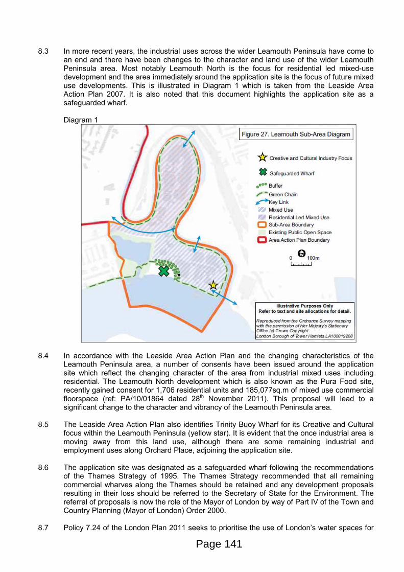
an end and there have been changes to the character and land use of the wider Leamouth Peninsula area. Most notably Leamouth North is the focus for residential led mixed-use development and the area immediately around the application site is the focus of future mixed use developments. This is illustrated in Diagram 1 which is taken from the Leaside Area Action Plan 2007. It is also noted that this document highlights the application site as a safeguarded wharf.
Diagram 1
8.4
In accordance with the Leaside Area Action Plan and the changing characteristics of the Leamouth Peninsula area, a number of consents have been issued around the application site which reflect the changing character of the area from industrial mixed uses including residential. The Leamouth North development which is also known as the Pura Food site, recently gained consent for 1,706 residential units and 185,077sq.m of mixed use commercial floorspace (ref: PA/10/01864 dated 28th November 2011). This proposal will lead to a significant change to the character and vibrancy of the Leamouth Peninsula area.
8.5 The Leaside Area Action Plan also identifies Trinity Buoy Wharf for its Creative and Cultural focus within the Leamouth Peninsula (yellow star). It is evident that the once industrial area is moving away from this land use, although there are some remaining industrial and employment uses along Orchard Place, adjoining the application site.
8.6 The application site was designated as a safeguarded wharf following the recommendations of the Thames Strategy of 1995. The Thames Strategy recommended that all remaining commercial wharves along the Thames should be retained and any development proposals resulting in their loss should be referred to the Secretary of State for the Environment. The referral of proposals is now the role of the Mayor of London by way of Part IV of the Town and Country Planning (Mayor of London) Order 2000.
8.7 Policy 7.24 of the London Plan 2011 seeks to prioritise the use of London’s water spaces for
Page 141

the transportation of freight. Policy 7.26 specifically deals with safeguarded wharves in supporting their reactivation and resisting their loss unless the wharf is no longer viable or capable for waterborne freight handling. Policy 7.30 goes further to state that sites alongside canals and rivers should activate water spaces, particularly for transport.
8.8 In 2005, a London Plan Implementation Report reviewed all safeguarded wharves on the River Thames and recommended that Orchard Wharf’s safeguarding status remain in place. The report identified Orchard Wharf as being capable of being made viable for cargo handling, particularly for transhipped aggregates.
8.9 Policy 7.26 of the London Plan 2011 states that the Mayor will review the designation of safeguarded wharves prior to 2012. The GLA are currently undertaking a further safeguarded wharves review. The consultation draft was released in October and consultation closed in January 2012. Within this consultation draft, Orchard Wharf had been retained as a safeguarded wharf. The site was considered to be viable and well located to serve London and satisfy the forecast shortfall of aggregate supply in the sub-region. Officers have therefore given weight to the retention of the safeguarding of Orchard Wharf within the Review document.
8.10 The draft Safeguarded Wharves 2011 document is currently being reviewed in light of comments received during the consultation period. The final safeguarded wharves document will now be produced and was expected to be sent to the Secretary of State with recommendations in early Spring 2012. The draft document has therefore been afforded some weight due to the retention of the safeguarded wharf status of the site and is a material consideration in the determination of this planning application.
8.11 The Lower Lea Valley Opportunity Area Planning Framework 2007 identifies the application site as a safeguarded wharf and protects its use for cargo-handling uses, including waste and aggregates in line with national and strategic policy.
8.12 At a local level, the safeguarded wharf status of the application site is identified within policy SP12 of the Core Strategy 2012 and site allocation LS22 of the Leaside Area Action Plan which seeks to protect the safeguarded status of Orchard Wharf for cargo handling operations and states that development which may prejudice these operations will not be supported. The Core Strategy goes on to state that effective buffers are needed to protect the amenity of nearby residential uses.
8.13 In land use terms, the national safeguarding of the application site has informed the regional and local policy documents of the Leamouth Peninsula area. Whilst the area in general is moving away from a principally industrial use, the safeguarding direction has been retained and therefore the principle of re-activating the site for aggregate storage and concrete batching on balance accords with planning policies.
8.14 Representations have been received raising concerns regarding the impact of the
development on the regeneration of the Lower Lea Valley, future investment in the local area and the impact on employment generation at local regeneration sites. On balance, it is considered that the safeguarded status of the site outweighs the potential future impacts on the surrounding area.
Design, Views, Heritage & Conservation 8.15 Good design is central to the objectives of national, regional and local planning policy. Policy
3.5 of the London Plan provides guidance on the quality and design of housing developments and specifies a number criterion aimed at achieving good design. These criterion are reflected in saved policies DEV1, DEV2 and DEV3 of the UDP; strategic objectives and policies SO20, SO21, SO22, SO23 and SP10 of the CS, policies DM23 and DM34 of the emerging MD DPD and IPG policies DEV1 and DEV2.
Page 142

8.16 These policies require new development to be sensitive to the character of the surrounding
area in terms of design, bulk, scale and the use of materials. They also require development to be sensitive to the capabilities of the site.
8.17 Furthermore, policy DEV2 of the IPG, supported by policy SP10 of the CS and DM24 of the
MD DPD (proposed submission version January 2012) also seeks to ensure new development creates buildings and spaces that are of high quality in design and construction, are sustainable, accessible, attractive, safe and well integrated with their surroundings.
Design 8.18 The approach to the design of the development has taken account of the industrial context of
the existing site and the history of the surrounding area. Consideration has also been given to the sites prominent location on the River Thames and adjacent to the EIDB. The buildings are designed simply for function and enclose the machinery and storage areas associated with the proposed use. More traditional features that would be associated with the historic warehouse buildings have also been incorporated into the design, such as dual pitched roofs and earthen colours. A condition is to be imposed to ensure the final materials used on the building facades are agreed prior to the commencement of development.
8.19 The layout, bulk and scale of the development is considered to relate to the existing buildings
located to the north and east of the site. Whilst the EIDB does not comprise any buildings, the proposal has been set away from the western boundary and a landscaped buffer zone provided to minimise the visual impact of the proposal from the EIDB. The image below shows an artists impression of the proposal juxtaposed against the EIDB.
8.20 On balance due to the safeguarding of the Wharf, the proposed development is considered
acceptable in terms of design, bulk and scale and massing. The design and scale of the new building is in keeping with the surrounding properties in terms of general building line and height. This is in line with saved policy DEV1 of the UDP; strategic objectives and policies SO20, SO21, SO22, SO23 and SP10 of the CS, policies DM23 and DM34 of the emerging MD DPD and IPG policy DEV2.
8.21 In respect of the outline part of this development, the detailed design and appearance of the jetty and ship to shore conveyor will be a reserved matter. The quality of design secured as part of the detailed development will act a benchmark to ensure that the remaining development is in keeping with the appearance of the landward development in order to
Page 143

ensure an appropriate design solution for the site.
Views Assessment 8.22 A townscape and visual assessment of the proposed development has been undertaken and
forms part of the Environmental Statement. This has analysed both the landscape and visual effects of the development compared to the existing situation.
8.23 The landscape character areas most likely to be effected by the development are the areas
around the River Lea and River Thames. 8.24 The River Thames is considered to be a high sensitivity landscape area and will be directly
affected by the jetty, conveyor and aggregate storage building. However, the buildings and jetty are considered to be appropriate in their scale and function given the type of other industrial infrastructure along the River Thames.
8.25 The visual affects of the proposal on surrounding areas has been assessed from 15 separate vantage points, including the East India Dock Basin, the Canning Town DLR station and also views from the LB Greenwich. The Environmental Statement concludes that three points are considered to be effected by a moderate to substantial degree but to a positive extent. These views are from the east side of the Virginia Quay development and from two points within East India Dock Basin.
8.26 The proposed development is of a larger scale than the buildings which exist on the site at
present. However, on balance it is not considered that the proposals cause an adverse impact on the setting of the site within the local views afforded to the site. Whilst the site is within a prominent riverfront location, views from the LB Greenwich and the EIDB are considered to provide a vista which is not altered to a degree that it overrides the safeguarding status of the Wharf.
8.27 On balance, the proposals are considered to be acceptable in relation to the local views and value of the East India Dock Basin nature reserve and riverfront views into the site. The proposal therefore accords with DEV8 of the UDP 1998, CON5 of the IPG 2007 and SP10 of the Core Strategy 2010.
Heritage Assessment 8.28 Policies CON1 and CON2 of the IPG 2007, policy SP10 of the Core Strategy 2010 and DM27
of the MD DPD 2012 seek to ensure that development preserves or enhances the distinctive character or appearance of an areas heritage assets in terms of scale, form, height, materials, architectural detail and design.
8.29 The applicant has submitted a Cultural Heritage Desk Based Assessment in support of the application and Environmental Statement. The Assessment analyses surrounding statutory listed structures, the unlisted structures on site for historic interest and archaeological assessments of the site
8.30 The closest listed structures to the site are the Grade II listed Blackwall Pier and entrance
lock to East India Dock Basin. These are located to the west of the application site and its setting primarily relates to the River Thames, as most of its landside dock setting has been removed and surrounded by modern residential development, road infrastructure and open space. The proposed development is not considered to impact on the setting of these listed structures due to the distance from the site and the orientation of the structures.
8.31 Further to the east of the site, further Grade II structures are present at Trinity Buoy Wharf.
These are the Trinity House Buoy Wharf and Orchard Dry Dock, and Trinity House Chain Locker and Lighthouse Block. The distance from the site coupled with the obstruction of
Page 144

direction sight lines between the two locations mean that the development of Orchard Wharf will have little to no impact upon these listed structures at Trinity Buoy Wharf.
8.32 Given the location of the surrounding listed buildings and structures which are not within the
immediate vicinity of the site, it is considered that the proposals would not detrimentally impact upon the setting of the adjoining heritage assets. The proposal is considered to be in accordance with policies CON1 and CON2 of the IPG, SP10 of the CS and DM27 of the MD DPD.
8.33 In terms of archaeological remains on the site, the assessment has indicated that there remains a high potential for post-medieval and palaeo-environmental remains to be on site. There is also considered to be a moderate potential for Neolithic and Bronze Age evidence remaining within the site. English Heritage has reviewed the assessment and has recommended a condition to secure archaeological investigations on site.
Amenity
Noise and Vibration
8.34 Policy 7.15 of the London Plan, saved policies DEV2 and DEV50 of the UDP, policies SP03
and SP10 of the Core strategy and policy DM25 of the MD DPD seek to ensure that development proposals reduce noise, minimising the existing and potential adverse impact and separate noise sensitive development from major noise sources.
8.35 The application site is located opposite 42-44 Orchard Place which comprises live work units,
which face directly onto the application site. The Virginia Quays residential area is located approximately 100 metres to the west of the site. Directly adjoining the western boundary of the site is the EIDB nature reserve and other sensitive receptors within the area include commercial premises along Orchard Place. A full noise and vibration assessment has been undertaken by Sharps Acoustic and is submitted within the Environmental Statement.
8.36 The Environmental Statement reviews the impact of the proposed construction phase of the development alongside the operational phase of the development which includes the aggregate handling facility, concrete batching plant and cement terminal.
8.37 The demolition and construction phase of the development is anticipated to be approximately 6-9 months and the hours of working during the construction phase will be conditioned to minimise a nuisance to local residents. It has been identified within the Environmental Statement that only works of piling within the landward part of the site (excluding piling works proposed at the quay wall/riverside) could exceed the LBTH noise and vibration limits and impact on local residents. At the time of submission, it was not known the extent of piling required within the landward part of the site, therefore a condition has been imposed which requires the applicants to submit and have approved details of any piling works within the landward area of the site. The applicants also propose to use localised screening to mitigate noise impacts in the event that piling is required.
8.38 A detailed assessment of the noise and vibration levels for the proposed development during the operation phases are contained within the Environmental Statement submitted. The assessment reviews the impact of the proposed works throughout the proposed operating hours of the development. The proposed works are identified as having a minor adverse impact on the live work units at 42-44 Orchard Place. On site mitigation measures proposed include the enclosure of the concrete and cement plants, ancillary equipment and conveyors, screening and road re-surfacing at Orchard Place. The on-site mitigation measures are considered to minimise the impacts on adjoining occupiers of Virginia Quay and Trinity Buoy Wharf. Full details of the proposed impact on the East India Dock Basin are set out within the ‘Biodiversity’ section below.
Page 145
8.39 As a result of the identified minor adverse impact on residents of the live work units at 42-44 Orchard Place, the Local Planning Authority sought mitigation measures for residents within the live work units most affected, on the south east and south west facades. As a result, the applicants propose to provide a scheme of works for all residents of the live works units which have a habitable room (bedrooms and living rooms/kitchen dining areas) of the south east and south west façade, to install secondary glazing and passive ventilation at the property. This will enable residents to install glazing and ventilation to provide adequate mitigation against the impacts of the development. The scheme of works will be secured through a legal agreement and the applicants are required to approach all residents of the live work unit as part of the legal agreement. In addition, the potential vibration impacts from the vehicular traffic entering and leaving the site is proposed to be mitigated through the re-surfacing of Orchard Place.
8.40 The Local Planning Authority has also been made aware that the London City Airport proposals include mitigation measures to provide all properties at 42-44 Orchard Place with double glazing and passive ventilation. Residents who already have double glazing would not however benefit from the upgrade works to glazing, but could receive the passive ventilation proposed through the London City Airport proposals. Nevertheless, residents would remain entitled to the Noise Insulation Works fund proposed by the applicants to provide a secondary glazing installation at the affected rooms on the south east and south west facade.
8.41 A Noise Management Strategy condition is also proposed as part of any consent issued at the site in order to monitor the noise levels following the implementation of the aggregate storage and concrete batching plant.
8.42 The measures proposed seek to provide reasonable mitigation to address the impacts on the amenity of existing and future adjoining occupiers. The proposal is therefore considered to accord with policy 7.15 of the London Plan, saved policies DEV2 and DEV50 of the UDP, policies SP03 and SP10 of the Core strategy and policy DM25 of the MD DPD which seek to ensure that development proposals reduce noise minimising the existing and potential adverse impact.
Air Quality
8.43 Policy 7.14 of the London Plan 2011 seeks to ensure that design solutions are incorporated into the new development to minimise exposure to poor air quality. Saved policy DEV2 of the UDP, policy SP02 of the Core strategy and policy DM9 of the MD DPD seek to protect the Borough from the effect of air pollution, requiring the submission of air quality assessments demonstrating how it will prevent air pollution in line with the Clear Zone objectives.
8.44 The development is located within the Tower Hamlets Air Quality Management Area (AQMA). The main sources of pollution impacting air quality are traffic emissions and dust and fine particulates from the proposed use. The submitted Environmental Statement advises that as a result of the enclosure of much of the site, including the aggregates depot which is enclosed except above the loading apron and through the provision of fixed water sprays, the development seeks to ensure that cement dust is not released at any stage of the process. Much of the requirements for ensuring the air quality in and around the site are imposed through separate conditions under the Environmental Permit, which the site is required to apply for.
8.45 Departing aggregates and cement lorries will pass through the wheel-wash and departing aggregate lorries will be covered prior to leaving the site to seek to prevent dust leaving the site. A road sweeper will also be deployed on a weekly basis and duties may also include the cleaning of Orchard Place if it considered necessary. The anticipated impact from exhaust emissions is assessed as a ‘slight adverse’ impact.
8.46 Whilst a number of mitigation measures are incorporated into the design proposal at
Page 146

application stage, under the requirements of the Environmental Permit for the site, should dust emissions occur or appear likely to occur, the operators would be required to be modified, reduced or suspended. Whilst the Environmental Permit falls outside of the application processes, the checks and balances imposed by the Environmental Permit seek to prevent an adverse impact on surrounding air pollution.
8.47 An Air Quality and Dust Management condition is proposed to be imposed as part of any consent issued at the site in order to monitor the air quality in and around the site following the implementation of the aggregate storage and concrete batching plant.
Daylight, Sunlight and Overlooking
8.48 Saved policy DEV2 of the UDP and SP10 of the CS seek to ensure that adjoining buildings are not adversely affected by a material deterioration in their daylighting and sunlighting conditions, overlooking/loss of privacy and sense of enclosure. Policy DEV1 of the IPG states that development should not result in a material deterioration of residential amenity for surrounding occupants.
8.49 The proposed development, by virtue of its scale, design and massing is not considered to
result in the loss of daylight and sunlight surrounding the site. In addition the distance and orientation of the proposed office building is unlikely to cause any loss of privacy to the live work units at Orchard Place or adjoining occupiers. The proposals are considered to accord with policy SP10 of the Core Strategy 2010, saved policy DEV2 of the UDP and policy DM25 of the MD DPD which seek to protect the amenity of existing a future occupiers.
Biodiversity
8.50 National policy guidance contained within the National Planning Policy Framework (NPPF) states that planning policies (Local Plan policies) should minimise impacts on biodiversity and geodiversity and promote the preservation, restoration and re-creation of priority habitats, ecological networks and the protection and the recovery of priority species populations, linked to national and local targets. The Local Planning Authority Biodiversity Action Plan (BAP) provides the background information which informed the adopted Core Strategy 2010 with regard to the policy formulation for Biodiversity promotion and preservation.
8.51 The NPPF also states that local authorities should aim to conserve and enhance biodiversity when determining planning applications. The NPPF goes on to set out that where significant harm results from a development, adequate mitigation should be provided and as a last resort, compensated for, through opportunities to incorporate biodiversity in and around a development. (paragraph 118).
8.52 The NPPF states that planning decisions should aim to protect areas of tranquillity which have remained relatively undisturbed by noise and are prized for their recreational amenity value. The East India Dock basin which adjoins the site is a nature reserve which is designated as a Site of Nature Conservation Importance and an Area of Metropolitan Open Land. The Dock Basin was converted to a bird reserve in 1996.
8.53 Policy 7.19 of the London Plan 2011 primarily reiterates the guidance of the NPPF and seeks a hierarchical approach to the protection, enhancement, creation, promotion and management of biodiversity. In the first instance development should seek to avoid any adverse impact on biodiversity. If an impact cannot be avoided, the impact should be minimised and mitigated and in exceptional circumstances, compensation can be sought where the benefits of the proposal outweigh the biodiversity impacts.
8.54 Policy SP04 of the Core Strategy 2010 seeks to protect and enhance biodiversity value in order to achieve a net gain in biodiversity. The Planning Obligations SPD also highlights the need for a net gain in biodiversity, but recognises that where it is unfeasible for a
Page 147
development to provide on-site biodiversity enhancements, the Council will seek financial contributions to off-site projects of Biodiversity enhancement.
8.55 The application site comprises a brownfield site. The site has been vacant for a number of years and as a result the site now presents a brownfield habitat. The site is located adjacent to the River Thames which is a designated Site of Metropolitan Importance for its Nature Conservation value. The adjoining East India Dock Basin is a Site of Borough Importance: Grade I for its nature conservation value.
8.56 Brownfield habitats are Priority Habitats in the UK, London and Tower Hamlets Biodiversity Action Plans. The habitat within such sites often supports many species and habitat types that are a priority for nature conservation. A detailed assessment of the value and potential impact upon a number of habitats and species has been undertaken by URS Scott Wilson and is detailed within the submitted Environmental Statement. An assessment of the adjoining River Thames and East India Dock Basin is also contained within the Environmental Statement. The survey work assessed the existing habitats, and species including black redstarts, breeding and wintering birds, bats, terrestrial invertebrates, reptiles, aquatic invertebrates and fish.
8.57 The application proposes to clear the site which will result in the loss of all existing habitats within the boundary of the site. The proposals include a range of mitigation measures to seek to ensure the translocation of species including kidney vetch, hares-foot clover and common storks-bill plants and the provision of black redstart boxes, bat roosting boxes and invertebrate boxes. Alongside this are a variety of measures to secure biodiversity at the site such as a brownfield habitat zone between the river wall and the development, provision of a landscape zone on the western boundary adjoining the East India Dock Basin, timber fendering along the side and rear walls of the aggregate bays, brownfield vegetation within the northern area of the site (fronting Orchard Place) and the provision of brown roofs on all available buildings within the site boundary including the concrete plant feed hoppers, weighbridge office, covered car parking spaces and the office building.
8.58 The area of brownfield habitat proposed within the application site is 1,886sq.m, which results in a net loss of brownfield habitat of 90sq.m. The proposal, as a result of the biodiversity enhancements provided on site is considered to result in a neutral impact on Biodiversity within the application site boundary. The neutral impact on Biodiversity at the site is reliant upon all Biodiversity measures proposed being successful. The proposed works are unable to deliver a biodiversity enhancement within the application site boundary.
8.59 The proposed works, by virtue of the type of noise generation from the use of the site (sudden noises), could impact on the biodiversity of the East India Dock Basin (EIDB). The sudden noises from the proposed works may deter use of the EIDB by noise sensitive birds, such as Teal. Off-site mitigation measures are proposed through the de-silting of the EIDB which would allow for the habitat within the Basin to be available to less noise sensitive birds which have been known to use the Basin in previous years. These works would provide a biodiversity enhancement at the Basin whilst accommodating for the proposed use adjacent to the EIDB. These measures seek to enhance the Biodiversity value of the EIDB and therefore mitigate against any residual impact upon the visitor experience and enjoyment of the Basin. The applicant has agreed to provide a planning obligation to seek to secure these works.
8.60 On balance, it is considered that the proposed works both on-site and off-site sufficiently seek to protect the biodiversity of the site and enhance the biodiversity of the adjacent EIDB. If all the proposed on-site mitigation and the de-silting of EIDB are carried out successfully, this should result in a net gain in Biodiversity which results in a neutral impact on its recreational amenity value in accordance with the NPPF. The works are therefore considered to accord with policy 7.19 of the London Plan 2011 and policy SP04 of the Core Strategy 2010 and the National Planning Policy Framework.
Page 148
8.61 Conditions are recommended to ensure the biodiversity enhancements are secured and all
necessary works for the translocation of species and habitats are implemented.
8.62 A full assessment of the impacts of the proposed development on the River Thames is provided within the URS Scott Wilson report. It should however be noted that all works for the jetty (and ship to shore conveyor) which are proposed to be located 74 metres into the River Thames have been submitted in outline, therefore all matters with regard to location will be a consideration under the reserved matters application. As such, further mitigation measures specifically designed to reduce the impact on the River Thames will be secured if necessary at the reserved matters stage in consultation with the Environment Agency.
Transport, Connectivity & Accessibility
8.63 Policy 6.3 of the London Plan seeks that transport demands generated by development proposals are within capacity. Such assessment is to be in accordance with TfL’s Transport Assessment Best Practice Guidance. The London Plan also emphasises the desire to maximise the movement of freight by water in line with policies 7.24, 7.26 and 7.30. These policies are reinforced through the Mayor’s Transport Strategy which highlights that water transport is particularly suited to bulky movements of relatively low value cargoes for which speed is less critical, aggregates and waste being prime examples.
8.64 Saved UDP policies T16, T18, T19 and T21, Core Strategy Policy SP08 & SP09 and Policy DM20 of the draft Managing Development DPD (2012) together seek to deliver an accessible, efficient and sustainable transport network, ensuring new development has no adverse impact on the safety and road network capacity, requires the assessment of traffic generation impacts and also seeks to prioritise and encourage improvements to the pedestrian environment.
8.65 The site's location on the southern limb of Orchard Place means that traffic serving the site has no alternative other that to use the A1020 Lower Lea Crossing in order to access the wider London road network. The A1020 crosses Orchard Place as a raised flyover. Slip roads to and from this flyover are only located on the western side of Orchard Place. There the entry onto the A1020 from Orchard Place is in a westerly direction only, and access from the A1020 to Orchard Place is from an easterly direction only. This arrangement means that all traffic either accessing or egressing the site are required to use the Leamouth roundabout to the west of the site.
8.66 Orchard Place is a historic industrial road, narrow with 1.5 metre footways either side. Between the application site and the A1020 the carriageway width varies from 6.1 metres to 7 metres. Although narrow, the applicant has demonstrated on site to officers that the types of concrete vehicles using the site can pass one another in opposite directions.
8.67 The intention of the operation is that all bulky deliveries of aggregates (including sand) and cement materials will be imported by river, involving no road transport. The onward deliveries of aggregate, cement and concrete to the market place (sites) will occur by road.
8.68 The total import of aggregates by barge to the site is expected to be 350,000 tonnes per annum. The total import of cement is intended to be 260,000 tonnes per annum by barge. The production of concrete from the batching plant is expected to be 100,000m3 per annum, using 35,000 tonnes of cement and 200,000 tonnes of aggregate.
Freight Movements 8.69 Saved policy T26, policy SP08 of the Core Strategy, policy DM21 of the MD DPD 2012 and
policy 6.14 of the London Plan 2011 seek to maximise the use of the waterways for the movement of freight and bulky goods to take movements off the strategic road network.
Page 149
8.70 As set out above, the principle delivery of aggregates (including sand) and cement materials
is to be via the River Thames. A condition is proposed to be imposed which requires all such materials to be delivered by river to prevent an exacerbation of vehicular movements. As such the development maximises the use of the waterways and complies with strategic and local policies.
8.71 A condition has been imposed which restricts unloading of ships and barges between the hours of 7am and 11pm, Monday to Saturday. No operation to unload ship and barges is permitted on Sundays and Bank Holidays. Unloading of ships and barges can take up to 36 hours and as there is no overnight working, ships may be docked for longer than 36 hour periods.
Vehicular Traffic Impact 8.72 The Transport Statement provides a detailed breakdown of the estimated vehicle movements
per day on an hourly basis. From 7am to 1pm the site is expected to generate between 19 and 21 vehicle movements per hour. In the afternoon and evenings this figure is expected to decrease from 18 movements from 2pm to 3pm, then 13, 10, 8, 3 and 3 in the hours following.
8.73 The Transport Statement has also considered vehicle movements generated by the 30 staff members using the site. The first consideration is that staff members are likely to arrive at the site before the morning traffic peak and leave after the evening peak. Although it is difficult to predict the transport modal split for staff members, the Transport Statement has allowed for 35 movements per day.
8.74 Adding all vehicle movements together, a total of 198 HGV movements plus 35 car movements are anticipated.
8.75 Given a (rounded) figure of 200 HGV movements per day on Orchard Place, the increase in traffic is expected to be 25% on top of existing flows in Orchard Place. Although the proportional increase in vehicle numbers is high, this is largely due to the existing low vehicle flows experienced in Orchard Place. The resultant total vehicle flow for Orchard Place is expected to be 989 movements per day.
8.76 Following discussion with TfL and Tower Hamlets Highways officers, further analysis of the traffic impact on Orchard Place has been undertaken with the context of the approved mixed use residential scheme on Leamouth Peninsula and the consented Leamouth Wharf scheme on the Leamouth roundabout. The impact of traffic generated by the scheme and assessed cumulatively with the Leamouth Peninsula scheme to the north is considered to be acceptable. Tower Hamlets Highways Officers have confirmed they are satisfied with the analysis and are content with the conclusions, and accordingly it is considered that the proposed use will not have an unduly detrimental impact upon the freeflow of traffic.
Highway Safety 8.77 The Transport Statement has considered data obtained from the London Accident Analysis
Unit of TfL from the past three years to 31st May 2011. This reveals that no injury accidents have occurred in Orchard Place or on either slip roads connecting to the A1020.
8.78 The entrance is located on the outer bend of Orchard Place and emerges through the boundary wall. The development proposal retains the existing access and removes three metres of the boundary wall either side of the entrance to be replaced with wire mesh to create greater visibility between drivers and pedestrians.
8.79 The second access to be created on Orchard Place will serve all movements associated with
Page 150

the concrete batching plant. The site boundary fence will be set back from the back edge of the footpath to create a two metre wide pedestrian pavement and 2.4m x 56m visibility splays for drivers.
8.80 Both site accesses have been designed so that HGVs leaving the site are able to turn onto Orchard Place without crossing the road centreline. Track plots have been provided that demonstrates these vehicle manoeuvres.
8.81 As part of the S278 works at the site, a pedestrian refuge is proposed to be provided in the centre of the carriageway at Orchard Place to provide safe crossing. These measures coupled with footpath widening seek to provide highway safety measures along Orchard Place.
Parking
8.82 Fourteen staff and visitor parking bays are to be provided adjacent to the site office. Cycle parking facilities are also to be provided. Both the car and cycle parking details are to be secured by condition to ensure they are maintained in perpetuity.
8.83 Parking of all vehicles when not in use, for example overnight or in non-operational periods, will be parked within the application site. A condition is also to be imposed to secure that the parking of all vehicles associated with the operation, servicing, delivery, staffing and/or visitation of the site will be contained within the site confines. This will ensure no parking of HGVs on the public highway.
Thames Path
8.84 In addition to the widened pedestrian pathways surrounding the site entrances, the scheme also proposes an extension to the Thames Path along the site’s river frontage. This path is to extend from East India Dock Basin, along the edge of the flood defence wall to the site’s eastern boundary where it will turn 90 degrees north to link back to Orchard Place. The path is to be five metres wide with an additional five metre wide landscape strip between the path and the southern site boundary.
8.85 As well as providing an additional area of accessible riverside, the extension to the Thames Path gives pedestrians an option for by passing the site entrances on Orchard Place when heading east to Trinity Buoy Wharf. Pedestrians approaching from the north of the site would enter East India Dock Basin and use the Thames Path extension to loop around the south of the site, although this would add time and distance to a walking journey. Alternatively, pedestrians could bypass the Leamouth Roundabout and Lower Lea Crossing altogether by using the Thames Path along the Virginia Quay development, across the locks and East India Dock Basin and then utilise the Thames Path extension along the proposal site to link to Orchard Place. This may be a desirable route for people using East India DLR station to the west.
8.86 It is noted that objections have been received relating to the impact of the proposal on the FAT walk which extends to the EIDB. The application proposes an extension of the existing Thames Path Walkway which currently only extends to the EIDB and will therefore improve the extent of the overall FAT walk and will allow for the creation and extension to this walkway through the development site. It is not considered that the development proposals will on balance detrimentally impact on the FAT walk. The creation and provision of the extension to this walkway accords with policy SP04 of the Core Strategy 2010.
8.87 On balance, transport matters, including parking, access and servicing, are considered acceptable and in line with policies T16 and T19 of the Council’s Unitary Development Plan (1998), policy SP08 and SP09 of the Core Strategy (2010) and DM20 and DM22 of the Draft Managing Development DPD (2012), which seek to ensure developments minimise parking
Page 151

and promote sustainable transport options. Energy & Sustainability
8.88 London Plan policies contained within chapter 5 and policy SP11 of the Core strategy 2010
collectively require development to make the fullest contribution to the mitigation and adaptation to climate change and to minimise carbon dioxide emissions.
8.89 The London Plan sets out the Mayor of London’s energy hierarchy which is to: - Use lean Energy (Be Lean); - Supply Energy Efficiently (Be Clean); and - Use Renewable Energy (Be Green).
8.90 The London Plan 2011 includes the target to achieve a minimum 25% reduction in CO2
emissions above the Building Regulations 2010 through the cumulative steps of the Energy Hierarchy (Policy 5.2).
8.91 Policy SO3 of the Core Strategy seeks to incorporate the principle of sustainable development, including limiting carbon emissions from development, delivering decentralised energy and renewable energy technologies and minimising the use of natural resources. The LB Tower Hamlets Core Strategy policy SP11 requires all new development to provide a 20% reduction of carbon dioxide emissions through on-site renewable energy generation.
8.92 Policy DM29 of the draft MD DPD requires sustainable design assessment tools to be used to ensure that development has maximised use of climate change mitigation measures. At present the current interpretation of this policy requires commercial or non-residential schemes to achieve an excellent BREEAM rating.
8.93 Through Officer discussion it has been established that due to the constraints of the site and the type of development proposed, it is not possible to achieve the reduction in carbon emissions required by London Plan or Local planning policies. The proposed development will deliver a 6% reduction in carbon emissions which are proposed through Photovoltaic panels on the roof of the buildings on the site. On balance the reduction of carbon emissions identified and the acceptable in this instance. The strategy to secure energy efficiency measures as proposed will be secured by condition to be delivered in accordance with the strategy submitted.
Contamination
8.94 In accordance saved UDP policy DEV51 and IPG policy DEV22 the application has been accompanied by an assessment of land contamination to assess whether the site is likely to be contaminated. The study has been reviewed by the Council’s Environmental Heath Officer who has recommended conditions ensuring the submission of further details.
Flood Risk 8.95 Policy 5.12 of the London Plan (2011), Policy SP04 of LBTH Core Strategy (2010) relate to
the need to consider flood risk at all stages in the planning process.
8.96 The site lies within Flood Risk Zone 3 and a sequential test has been undertaken. The Environment Agency has reviewed the sequential test and have accepted the details submitted.
8.97 The Flood Risk Assessment on the current scheme concludes that the risk of flooding to the development is most likely to come from the River Thames, rather than overland flooding, fluvial flooding or other types of flooding from drainage systems. The site is protected from tidal flooding by the Thames Barrier and on site flood defence walls.
Page 152
8.98 The development has the potential to increase the risk of flooding to the surrounding area by
increasing the impermeable area, thereby increasing surface water runoff. However, the site plans include a ‘wash out’ area where all surface water runoff will be collected for use in the concrete batching plant and for washing vehicles. The re-use of water on site will reduce the volume of surface water runoff leaving the site and it is anticipated that under normal operating conditions the need for water will outstrip the supply provided by runoff.
8.99 In an extreme rainfall event, underground storage for 1,134m3 will mean that runoff rates connecting to the Thames Water combined sewer can be limited to Greenfield runoff rates.
8.100 Subject to the imposition of conditions, the proposal is considered to reduce the impact and risk of flooding. The proposal therefore accords with policy 5.12 of the London Plan 2011, saved policy U2 of the UDP 1998, policy DEV21 of the IPG 2007 and policy SP04 of the Core Strategy 2010.
8.101 In respect of the outline phases, the applicant is required to undertake further survey work prior to the final layout and detail of the jetty. These details will also be required to ensure they reduce the impact and risk of flooding. All details at reserved matters stage will be issued to the Environment Agency for consultation.
Environmental Impact Assessment
8.102 The proposed development falls within the category of developments referred to in paragraph 10(b) of Schedule 2 of the Town and Country Planning (Environmental Impact Assessment) (England and Wales) regulations 2011.
8.103 As the proposal is likely to have significant effects on the environment, it is required to be subject to environmental impact assessment before planning permission is granted. Regulation 3 of the EIA Regulations precludes the grant of planning permission unless prior to doing so, the Council has taken the ‘environmental information’ into account. The environmental information comprises the applicant’s Environmental Statement (ES), any further information submitted following request under Regulation 22 of the EIA Regulations, any other substantive information relating to the ES and provided by the applicant and any representations received from consultation bodies or duly made by any person about the environmental effects of the development.
8.104 The ES addresses the following areas of impact (in the order they appear in the ES):
o Townscape and Visual o Ecology and Nature Conservation o Cultural Heritage o Land Quality o Transport and Access o Noise and Vibration o Air Quality o Water Resources o Marine Navigation Risk o Social and Community Effects o Mitigation and Monitoring
8.105 The Council appointed consultants, Land Use Consultants (LUC) to examine the applicant’s ES and to confirm whether it satisfied the requirements of the EIA Regulations. Following that exercise, LUC confirmed their view that whilst a Regulation 22 request was not required, further clarification was sought in respect of a number of issues. These issues have been satisfactorily addressed by the applicant and further review concluded that the ES have adequately addressed all the requirements of the EIA regulations.
Page 153

8.106 The various sections of the ES have been reviewed by officers. The various environmental
impacts are dealt with in relevant sections of this report above with conclusions given, proposals for mitigation of impacts by way of conditions, and/or planning obligations as appropriate.
8.107 In summary, having regard to the ES and other environmental information in relation to the development, officers are satisfied that the environmental impacts are acceptable in the context of the overall scheme, subject to conditions/obligations providing for appropriate mitigation measures.
Health Considerations
8.108 Policy 3.2 of the London Plan (2011) seeks to improve health and address health inequalities having regard to the health impacts of development proposals as a mechanism for ensuring that new developments promote public health within the borough.
8.109 Policy SP03 of the Core Strategy (2010) seeks to deliver healthy and liveable neighbourhoods that promote active and healthy lifestyles, and enhance people’s wider health and well-being.
8.110 Part 1 of Policy SP03 in particular seeks to support opportunities for healthy and active lifestyles through:
• Working with NHS Tower Hamlets to improve healthy and active lifestyles.
• Providing high-quality walking and cycling routes.
• Providing excellent access to leisure and recreation facilities.
• Seeking to reduce the over-concentration of any use type where this detracts from the ability to adopt healthy lifestyles.
• Promoting and supporting local food-growing and urban agriculture.
8.111 As part of the planning application, works to provide an extension to the Thames Pathway, from the adjoining EIDB through the development site are considered facilitate healthy and active lifestyles for users of the Thanes Pathway. It is therefore considered that the proposal meets the objectives of London Plan policy 3.2 and policy SP03 of the Core Strategy 2010 which seek to secure opportunities for healthy and active lifestyles.
Section 106 Agreement
8.112 Regulation 122 of CIL Regulations 2010 brings into law policy tests for planning obligations which can only constitute a reason for granting planning permission where they meet they are:
(a) Necessary to make the development acceptable in planning terms; (b) Directly related to the development; and (c) Are fairly and reasonably related in scale and kind to the development.
8.113 This is further supported by Saved Policy DEV4 of the UDP (1998) and Policy IMP1 of the Council’s IPG (2007) policy SP13 in the Core Strategy (2010) seek to negotiate planning obligations through their deliverance in kind or through financial contributions to mitigate the impacts of a development.
8.114 The Council’s Supplementary Planning Document on Planning Obligations was adopted in
January 2012; this SPD provides the Council’s guidance on the policy concerning planning obligations set out in policy SP13 of the adopted Core Strategy. The document also set out the Borough’s key priorities being:
Page 154

o Affordable Housing o Employment, Skills, Training and Enterprise o Community Facilities o Education
The Borough’s other priorities include:
o Public Realm o Health o Sustainable Transport o Energy and Biodiversity
Some of the above priority areas are not relevant to commercial developments, such as affordable housing.
8.115 LBTH and LTGDC are the determining authorities on the development site.
8.116 Based on the SPD, LBTH Officers have identified a contribution request of: a) £250,000 towards biodiversity enhancements at the adjoining East India Dock Basin and b) £14,768 towards Employment and Enterprise. A financial contribution of £264,768 has been agreed with the applicants. Non financial contributions are also proposed to be secured, these obligations comprise:
- Noise Insulation Works and Ventilation scheme for 42-44 Orchard Place; - Highway Works; - Travel Plan; - Employment and Training; and - Thames Path extension through the application site.
The non-financial obligations proposed are principally site specific requirements which seek to mitigate the impact of the proposed development and discussed within the relevant sections of the report. Details of Employment and Enterprise are provided below.
Employment and Enterprise
8.117 The SPD requires developments to exercise reasonable endeavours to ensure 20% of the construction phase workforce will be for local residents of Tower Hamlets, to be supported through the Skillsmatch Construction Services. In addition the SPD requires that 20% of the goods/services procured during the construction phase should be achieved by businesses in Tower Hamlets.
8.118 The SPD also seeks a financial contribution towards the training and skills need of local residents in accessing job opportunities created through the construction phase of all new development and a contribution towards end use phase of commercial developments. In addition the SPD states that in-house training programmes may be considered in lieu of the construction phase skills and training contribution; however this is assessed on a case by case basis.
8.119 The SPD also seeks a financial contribution to support and provide training for local residents new job opportunities created b the development. In addition best endeavours are sought to ensure a proportion of jobs are secured for local residents and apprenticeship schemes and work experience is provided to local residents.
8.120 The applicants are committed to supporting local employment and enterprise through the construction phase of the development and the end user phase. A financial contribution of £14,768 towards providing skills and training to local residents during the construction and
Page 155
end user phase of the development have been secured. In addition the applicants have agreed to work with the Local Authority to ensure 20% of the construction and end user phase employees are LB Tower Hamlets residents. Measures to secure 20% of goods and services during the construction phase from local LBTH businesses has also been secured. The applicants have also agreed to all end user phase vacancies being exclusively advertised via the Councils Access to Employment service, Skillsmatch to enable as many local residents the opportunity to access the jobs created by the development. These measures also secure the construction training requirements requested by the GLA.
Localism Act (amendment to S70(2) of the TCPA 1990)
8.121 Section 70(1) of the Town and Country Planning Act 1990 (as amended) entitles the local planning authority (and on appeal by the Secretary of State) to grant planning permission on application to it. From 15th January 2012, Parliament has enacted an amended section 70(2) as follows:
8.122 In dealing with such an application the authority shall have regard to:
a) The provisions of the development plan, so far as material to the application; b) Any local finance considerations, so far as material to the application; and c) Any other material consideration.
8.123 Section 70(4) defines “local finance consideration” as:
a) A grant or other financial assistance that has been, or will or could be, provided to
a relevant authority by a Minister of the Crown; or b) Sums that a relevant authority has received, or will or could receive, in payment
of Community Infrastructure Levy.
8.124 These issues now need to be treated as material planning considerations when determining
planning applications or planning appeals.
8.125 Officers are satisfied that the current report to Committee has had regard to the provision of the development plan. Regarding Community Infrastructure Levy considerations, following the publication of the London Mayor’s Community Infrastructure Levy, Members are reminded that the London Mayoral CIL is now operational, as of 1 April 2012. The likely CIL payment associated with this development would be approximately £5,950.
Human Rights Considerations
8.126 The application potentially raises some Human Rights Act 1998 implications. These are summarised in this section. In terms of relevant provisions of the Human Rights Act 1998, the following are particularly highlighted to Members:-
8.127 Section 6 of the Human Rights Act 1998 prohibits authorities (including the Council as local
planning authority) from acting in a way which is incompatible with the European Convention on Human Rights. "Convention" here means the European Convention on Human Rights, certain parts of which were incorporated into English law under the Human Rights Act 1998. Various Convention rights are likely to be relevant, including:-
o Entitlement to a fair and public hearing within a reasonable time by an independent and impartial tribunal established by law in the determination of a person's civil and political rights (Convention Article 6). This includes property rights and can include opportunities to be heard in the consultation process;
o Rights to respect for private and family life and home. Such rights may be restricted if the infringement is legitimate and fair and proportionate in the public interest
Page 156
(Convention Article 8); and o Peaceful enjoyment of possessions (including property). This does not impair the right
to enforce such laws as the State deems necessary to control the use of property in accordance with the general interest (First Protocol, Article 1). The European Court has recognised that "regard must be had to the fair balance that has to be struck between the competing interests of the individual and of the community as a whole".
8.128 This report has outlined the consultation that has been undertaken on the planning
application and the opportunities for people to make representations to the Council as local planning authority.
8.129 Members need to satisfy themselves that the measures which are proposed to be taken to
minimise, inter alia, the adverse effects of noise, construction and general disturbance are acceptable and that any potential interference with Article 8 rights will be legitimate and justified.
8.130 Both public and private interests are to be taken into account in the exercise of the Council's
planning authority's powers and duties. Any interference with a Convention right must be necessary and proportionate.
8.131 Members must, therefore, carefully consider the balance to be struck between individual
rights and the wider public interest. 8.132 As set out above, it is necessary, having regard to the Human Rights Act 1998, to take into
account any interference with private property rights protected by the European Convention on Human Rights and ensure that the interference is proportionate and in the public interest.
8.133 In this context, the balance to be struck between individual rights and the wider public interest has been carefully considered. Officers consider that any interference with Convention rights is justified. Officers have also taken into account the mitigation measures governed by planning conditions and the associated section 106 agreement to be entered into.
Equalities Act Considerations 8.134 The Equality Act 2010 provides protection from discrimination in respect of certain protected
characteristics, namely: age, disability, gender reassignment, pregnancy and maternity, race, religion or beliefs and sex and sexual orientation. It places the Council under a legal duty to have due regard to the advancement of equality in the exercise of its powers including planning powers. Officers have taken this into account in the assessment of the application and the Committee must be mindful of this duty inter alia when determining all planning applications. In particular the Committee must pay due regard to the need to:
1. eliminate discrimination, harassment, victimisation and any other conduct that is prohibited by or under the Act;
2. advance equality of opportunity between persons who share a relevant protected characteristic and persons who do not share it; and
3. foster good relations between persons who share a relevant protected characteristic and persons who do not share it.
8.135 The contributions towards various biodiversity enhancements and infrastructure
improvements addresses, in the short-medium term, the potential perceived and real impacts of the construction workforce on the local communities, and in the longer term support biodiversity enhancement at the East India Dock Basin and provide noise insulation works for residents at 42-44 Orchard Place.
8.136 Furthermore, the requirement to use local labour and services during construction enables
local people to take advantage of employment opportunities.
Page 157
Conclusions 9.0 All other relevant policies and considerations have been taken into account. Planning
permission should be granted for the reasons set out in the SUMMARY OF MATERIAL PLANNING CONSIDERATIONS and the details of the decision are set out in the RECOMMENDATION at the beginning of this report.
Page 158
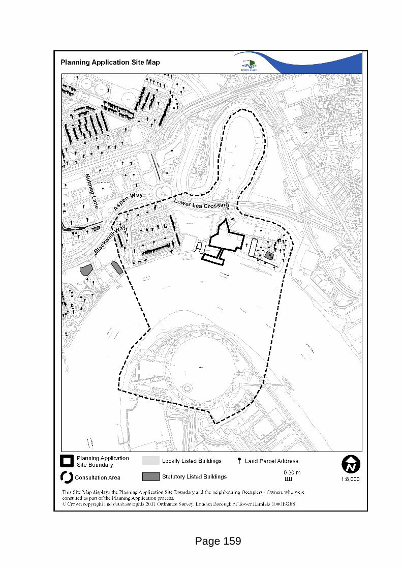
Page 159

Page 160
This page is intentionally left blank