agenda item: discuss and consider the execution of an
TRANSCRIPT

2/26/2019
Agenda Item: Discuss and Consider the Execution of an Interlocal Agreement with the City of
Galveston Related to Annual Beach Surveys (Reuben Trevino / Sheryl Rozier, 10 minutes)
Overview:
Historically the City of Galveston and the Park Board have worked together to perform annual beach surveys that determine the changes in volume of sand along the beachfront. This is especially important for our engineered beaches, as this historical information is used after a storm event to show comparative proof of loss in order to file a claim with FEMA. The current agreement was entered into in 2014 and has now concluded. The City put out a Request for Qualifications (RFQ) with the assistance of the Park Board and selected Aptim Environmental & Infrastructure, Inc. (Aptim) to conduct the next series of surveys. The basic scope of work is to conduct Depth of Closure and Wading Depth Surveys & a Proof of Methodology Study with drone technology. The Wading Depth Surveys will take place along the entire length of Galveston Island, excluding Galveston Island State Park and Jamaica Beach. The Depth of Closure surveys will be conducted on the three engineered beaches only. The Interlocal agreement refers to “Attachment A”. This document was the original RFQ from the City and the response from Aptim. This document is lengthy and not included in the briefing papers. “Exhibit A” outlines the best and final offer that was accepted by the City from Aptim. The Park Board will be responsible for the 100% of the costs incurred for the Depth of Closure surveys and 50% of the costs for the Proof of Methodology study. The Interlocal is a four-year agreement. It does account for Optional Services that allow for post storm surveys. These surveys would only take place in the event of a disaster where the City and Park Board feel there is a potential claim for beach damage with FEMA. The costs incurred for this type of survey is reimbursable with FEMA if the project is deemed eligible. The Interlocal Agreement and Exhibits have been reviewed by legal counsel. Staff Recommendation: Staff recommends execution of the Interlocal Agreement with the City of Galveston to conduct annual
beach surveys with Aptim.
Funding Source (if a budgetary item):
FY 2018-2019 BC 5204 & NB 5204

Interlocal Agreement for Beach Survey Costs Page 1 of 9 City of Galveston, Park Board of Trustees
INTERLOCAL AGREEMENT BETWEEN
THE CITY OF GALVESTON, TEXAS, AND
THE PARK BOARD OF TRUSTEES OF THE CITY OF GALVESTON, TEXAS
STATE OF TEXAS § § KNOW ALL MEN BY THESE PRESENTS: COUNTY OF GALVESTON §
This Interlocal Agreement is made and entered into effective on the _____ day of ________________, 2019, pursuant to the Texas Interlocal Cooperation Act, Chapter 791 of the Texas Government Code (the "Act"), by and between the City of Galveston (hereinafter referred to as "CITY"), and the Park Board of Trustees of the City of Galveston (hereinafter referred to as "PARK BOARD").
WITNESSETH:
WHEREAS, the Parties recognize the major economic and environmental asset in the beaches of Galveston Island; and
WHEREAS, preservation of Galveston beaches will help protect the environment, tax base, public infrastructure, and public access to beaches and recreational opportunities; and
WHEREAS, the Parties desire to enter into an agreement whereby each Party is responsible for a proportionate share of the costs associated with conducting beach surveys along Galveston Island; and
WHEREAS, in accordance with the Act, the CITY and the PARK BOARD recognize that any payments for the governmental functions or services performed under this Agreement are from available current revenues and such other appropriations available by the Parties; and
WHEREAS, the Parties agree that the respective rights, duties, and obligations, regarding this joint project are as specified in this Interlocal Agreement.
NOW THEREFORE, for and in consideration of the mutual covenants, obligations, and benefits hereunder, the Parties do hereby agree as follows:
Section 1. Incorporation of Recitals. The representations, covenants, and recitations set forth in the foregoing recitals are material to this Agreement and are incorporated into this Agreement.
Interlocal Agreement for Beach Survey Costs Page 2 of 9 City of Galveston, Park Board of Trustees
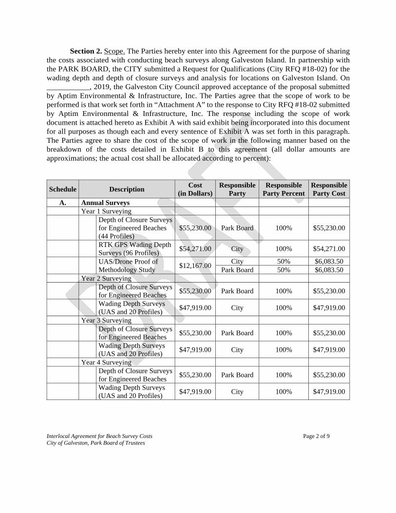
Section 2. Scope. The Parties hereby enter into this Agreement for the purpose of sharing the costs associated with conducting beach surveys along Galveston Island. In partnership with the PARK BOARD, the CITY submitted a Request for Qualifications (City RFQ #18-02) for the wading depth and depth of closure surveys and analysis for locations on Galveston Island. On ___________, 2019, the Galveston City Council approved acceptance of the proposal submitted by Aptim Environmental & Infrastructure, Inc. The Parties agree that the scope of work to be performed is that work set forth in “Attachment A” to the response to City RFQ #18-02 submitted by Aptim Environmental & Infrastructure, Inc. The response including the scope of work document is attached hereto as Exhibit A with said exhibit being incorporated into this document for all purposes as though each and every sentence of Exhibit A was set forth in this paragraph. The Parties agree to share the cost of the scope of work in the following manner based on the breakdown of the costs detailed in Exhibit B to this agreement (all dollar amounts are approximations; the actual cost shall be allocated according to percent):
Schedule Description Cost
(in Dollars)Responsible
Party Responsible
Party Percent Responsible Party Cost
A. Annual Surveys Year 1 Surveying
Depth of Closure Surveys for Engineered Beaches (44 Profiles)
$55,230.00 Park Board 100% $55,230.00
RTK GPS Wading Depth Surveys (96 Profiles)
$54,271.00 City 100% $54,271.00
UAS/Drone Proof of Methodology Study
$12,167.00 City 50% $6,083.50
Park Board 50% $6,083.50 Year 2 Surveying
Depth of Closure Surveys for Engineered Beaches
$55,230.00 Park Board 100% $55,230.00
Wading Depth Surveys (UAS and 20 Profiles)
$47,919.00 City 100% $47,919.00
Year 3 Surveying
Depth of Closure Surveys for Engineered Beaches
$55,230.00 Park Board 100% $55,230.00
Wading Depth Surveys (UAS and 20 Profiles)
$47,919.00 City 100% $47,919.00
Year 4 Surveying
Depth of Closure Surveys for Engineered Beaches
$55,230.00 Park Board 100% $55,230.00
Wading Depth Surveys (UAS and 20 Profiles)
$47,919.00 City 100% $47,919.00

Interlocal Agreement for Beach Survey Costs Page 3 of 9 City of Galveston, Park Board of Trustees
Schedule Description Cost
(in Dollars)Responsible
Party Responsible
Party Percent Responsible Party Cost
B. Optional Services
Post Storm Event Surveying (Category G Only)
Depth of Closure Surveys for Engineered Beaches
$55,230.00 * 100% $55,230.00
Contingency Cost to Restore Control Points (up to Four Control Points-2 Days)
$6,497.00 * 100% $6,497.00
Storm Assessment Report & Coordination with FEMA
$29,552.00 * 100% $29,552.00
Post Storm Event Surveying (Category B and G)
Depth of Closure Surveys for Engineered Beaches
$55,230.00 * 100% $55,230.00
Wading Depth Surveys (UAS)
$47,919.00 * 100% $47,919.00
Contingency Cost to Restore Control Points (up to Four Control Points-2 Days)
$6,497.00 * 100% $6,497.00
Storm Assessment Report & Coordination with FEMA
$41,027.00 * 100% $41,027.00
C. Beach Maintenance Plan – Optional
$47,600 ** 100% $47,600
D. Shoreline Change Analysis (Deleted from BAFO at City Request)
N/A
E. GIS Deliverables (Included with Survey Deliverables)
N/A
* The cost will be the responsibility of the Party that is the applicant for FEMA Project Worksheets.** The cost will be the responsibility of the Party that initiates this project.
Section 3. Insurance. Each Party agrees to provide the minimal level of general liability insurance as required by State law. In the event of any cause of action or claim asserted against the CITY or the PARK BOARD, the Party or Parties will provide the other Party or Parties timely notice of such claim, dispute or notice. Thereafter, to the extent allowed by law, the CITY and/or the PARK

Interlocal Agreement for Beach Survey Costs Page 4 of 9 City of Galveston, Park Board of Trustees
BOARD shall at their own expense, faithfully and completely defend and protect themselves against any and all liabilities arising from the claim, cause of action or notice.
Section 4. Liability. The Parties, being fully cognizant of the provisions of TEX. GOV'T. CODE § 791.006(a), nonetheless agree and intend that each shall be responsible for its own actions and those of its members, while providing emergency assistance, traveling to or from the scene of emergencies, or in any manner of providing services pursuant to and within the scope of this agreement, or a written supplement hereto. It is therefore expressly understood and agreed by the Parties that neither shall be held liable for the actions of the other Party or any of the other Party's members while in any manner furnishing services hereunder. Under no circumstances shall either Party be deemed an employee of the other Party. Any and all joint venture or partnership status is hereby expressly denied and the Parties expressly state that they have not formed, either expressly or impliedly a joint venture or partnership.
Section 5. Immunity Retained. No Party waives or relinquishes any immunity or defense on behalf of itself, its officers, employees and agents as a result of its execution of this Agreement and the performance of the covenants contained herein.
Section 6. Waiver of Claims Against Parties. Each Party hereto waives all claims against the other Party hereto for compensation for any loss, damage, personal injury, or death occurring as a consequence of the performance of this Agreement, except those caused in whole or in part by the negligence of an officer or employee of another Party. Provided however, that this waiver shall not apply in those cases in which the claim results from the failure of the requesting Party to accept responsibility for any civil liability for which the requesting Party is responsible as determined by the Interlocal Cooperation Act, Chapter 791 of the Texas Government Code, as amended.
However, neither Party waives, nor shall be deemed to waive, any immunity or defense that would otherwise be available to it against claims airing in the exercise of its governmental powers and functions.
This Agreement shall not be construed to be for the benefit of any third Party.
Section 7. Term. The term of this Agreement is for one (1) year with three (3) one-year options for a total of four (4) years, unless earlier terminated by providing 90 days written notice.
Section 8. Entire Agreement. This Agreement sets forth the entire agreement between the Parties with respect to the subject matter hereof, and all prior discussions, representations, proposals, offers, and oral or written communications of any nature are entirely superseded hereby and extinguished by the execution of this Agreement. No modification of, or waiver of any right under, this Agreement will be effective unless it is evidenced in writing, executed by an authorized representative of each Party to this Agreement.
Section 9. Compliance with All Applicable Laws. This Agreement is intended to enhance emergency planning by the Parties. It is not meant to supersede or negate any other Agreements entered into by the Parties. The Parties will comply with all applicable federal, state, and local laws, rules,

Interlocal Agreement for Beach Survey Costs Page 5 of 9 City of Galveston, Park Board of Trustees
ordinances and regulations affecting the conduct of services provided and the performance of all obligations undertaken by this Agreement.
Section 10. Venue. Venue of any dispute arising out of this agreement shall be in Galveston County, Texas.
Section 11. Headings. All headings and captions are for convenience only and shall not modify, limit or alter any provision of this Agreement.
Section 12. Authority. The Parties hereby respectively covenant, agree, represent, and warrant, each to the others, that this Agreement and any other documents to be executed and delivered by such Party in connection herewith is, and upon execution will be, duly authorized, executed, and delivered, and is, and upon execution will be, the legal, valid, and binding obligation of such Party, without the requirement of any further or additional approvals or consents and do not, and upon execution will not, violate any provisions of any agreement, obligation or applicable law, regulation, rule or order to which such Party is subject.
Section 13. Authority. The persons signing this Agreement on behalf of the CITY and PARK BOARD represent to each other that this Agreement, the transactions contemplated in this Agreement, and the execution and delivery of this Agreement have been duly authorized by all necessary governing bodies, corporate, partnership, or trust proceedings and actions, including, but not limited to, actions on the part of the directors, officers, and agents of CITY and PARK BOARD pursuant to section 791.001 et seq. of the Texas Government Code. The Parties further acknowledge that each other party may only act as authorized by law and that any act of an employee or officer that is not duly authorized is void.
Section 14. Understanding, Fair Construction. By execution of this Agreement, the Parties acknowledge that they have read and understand each provision, term, and obligation contained in this Agreement. This Agreement, although drawn by one Party, shall be construed fairly and reasonably and not more strictly against the drafting Party than the non-drafting Party.
Section 15. Attorneys Fees. In the event of any litigation to interpret or enforce the provisions of this Agreement then the prevailing Party shall be entitled to recover its reasonable attorneys' fees and expenses including costs of court from the non-prevailing Party.
Section 16. Severability. In case any one or more of the provisions contained in this Agreement shall for any reason be held to be invalid, illegal or unenforceable in any respect, such invalidity, illegality, or unenforceability shall not affect any other provision hereof or in the Lease or the Assignment, and this Agreement shall be construed as if such invalid, illegal or unenforceable provision had never been contained herein. Section 17. Notice. Any notice required to be given hereunder shall be in writing and delivered to the addresses and titles set forth below by certified mail (return receipt requested), a recorded delivery service, or by other means of delivery requiring a signed receipt. All notices shall be effective upon receipt. The addresses provided herein may be changed at any time on prior written notice.

Interlocal Agreement for Beach Survey Costs Page 6 of 9 City of Galveston, Park Board of Trustees
FOR THE CITY OF GALVESTON City Manager with copy to: City Attorney City of Galveston City of Galveston P.O. Box 779 P.O. Box 779 Galveston, Texas 77553 Galveston, Texas 77553 Phone: 409.797.3520 Phone: 409.797.3520 Fax: 409.797.3521 Fax: 409.797.3521 FOR THE PARK BOARD OF TRUSTEES Executive Director Park Board of Trustees of the City of Galveston 601 Tremont, Suite 201 Galveston, Texas 77550 Phone: 409.797.5000 Fax: 409.762.8911
Section 18. Counterparts. This Agreement may be executed in multiple counterparts, each of which shall be an original instrument and which taken together constitute one and the same agreement.
Section 19. Effective Date. This Agreement shall be effective as of the _______ day of _____________, 2019. CITY OF GALVESTON, TEXAS APPROVED AS TO FORM: By: ___________________________ By: ___________________________ Brian Maxwell Don Glywasky City Manager City Attorney THE PARK BOARD OF TRUSTEES OF APPROVED AS TO FORM: THE CITY OF GALVESTON, TEXAS

Interlocal Agreement for Beach Survey Costs Page 7 of 9 City of Galveston, Park Board of Trustees
By: ___________________________ By: ___________________________ Spencer Priest Carla Cotropia Chair of Park Board Counsel for the Park Board Chairperson for the Galveston Park Board of Trustees

Interlocal Agreement for Beach Survey Costs Page 8 of 9 City of Galveston, Park Board of Trustees
STATE OF TEXAS § § COUNTY OF GALVESTON §
BEFORE me _________________, a Notary Public, on this day personally appeared Brian Maxwell, City Manager of the CITY OF GALVESTON, TEXAS, a duly incorporated municipal corporation of the State of Texas, on behalf of said corporation, known to me to be the person whose name is subscribed to the foregoing instrument and acknowledged to me that he executed the same for the purposes and consideration therein expressed.
Given under my hand and seal of office this _____ day of ____________, 2019.
____________________________________ NOTARY PUBLIC in and for The State of Texas Typed or printed name of Notary My commission expires: ________________

Interlocal Agreement for Beach Survey Costs Page 9 of 9 City of Galveston, Park Board of Trustees
EXHIBITS A and B
Response from Aptim Including Scope of Work in Attachment A

EXHIBIT "A" SCOPE OF PROFESSIONAL SERVICES
CITY OF GALVESTON, TEXAS BEST AND FINAL OFFER
RFQ # 18-02 BEACH SURVEY
Aptim Environmental & Infrastructure, LLC. (APTIM) proposes to provide professional services to the City of Galveston, Texas (City) in accordance with the request for Best and Final Offer (BAFO) dated August 7, 2018. Services to be provided by APTIM under this agreement include annual beach surveys, optional post storm surveys and storm damage analysis reports, the preparation of a beach maintenance plan, and preparation of GIS data deliverables. These services are described in detail in the following sections.
SCHEDULE A - ANNUAL SURVEYS
Under Schedule A services, APTIM will conduct beach survey services for a four ( 4) year term.
Year 1 Surveying
During Year 1, APTIM will conduct beach profile surveys of 140 beach profiles along Galveston Island between Station 550+00, located approximately 1,000 ft. southwest of the South Jetty, and Station 570+00, located approximately 3,000 ft. northwest of San Luis Pass. Eleven profiles along Jamaica Beach and the Galveston Island State Park, namely Stations 1200+00 through 1100+00, are not included in the survey of Galveston Island. The survey is split into two parts based on whether the profile is located in the vicinity of an engineered beach project. The two types of surveys to be conducted will be "Depth of Closure Surveys" and "Wading Depth Surveys". In addition, in Year 1, APTIM will conduct a UAS/Drone proof of methodology study. The scope of work for each type of survey as well as the proof of methodology study is provided in the following sections.
Survey Control Reconnaissance:
Prior to the start of the surveys, reconnaissance of published National Geodetic Survey NGS 2nd order control (or higher) control monuments will be conducted to confirm that survey control is in place and undisturbed. Real Time Kinematic Global Positioning System (RTK GPS) and Static GPS techniques will be used to locate and confirm survey control for this project. Static GPS methods will also be utilized to establish temporary benchmarks (TBMs) in the event that the published survey control is disturbed or insufficient to cover the entire survey area. Survey control from historic survey events will be located and utilized to allow for past survey comparison and datum compatibility.
Horizontal and vertical positioning checks will be conducted at the beginning and end of each survey day using at least two 2nd order monuments or TBMs in the project area to ensure system and network stability. RTK GPS utilizes statistical methods to ensure data remains within the 95% confidence interval and meets the accuracy required for this survey.
A-I

EXHIBIT "A" SCOPE OF PROFESSIONAL SERVICES
CITY OF GALVESTON, TEXAS BEST AND FINAL OFFER
RFQ # 18-02 BEACH SURVEY
All horizontal pos1t1ons will be collected in US survey feet relative to the North American Datum of 1983/201 I (NAO 83/11). All vertical data will be collected in US survey feet relative to the North American Vertical Datum of 1988 (NAVO 88), Geoid 12b.
Costs associated with establishing survey control are incorporated into the cost of Depth of Closure and Wading Depth surveys.
Depth of Closure Surveys
The standard method used to monitor beach nourishment projects involves conducting repeated beach profile surveys to determine the changes in volume of sand along the beach nourishment project. During the construction of a beach nourishment project, the addition of sand along a particular portion of the beach, creates a protrusion in the shoreline. Over time, natural wave forces work to smooth this un-natural alignment back to a more straight alignment. That process typically occurs through the spreading or diffusion of sand laterally off of a project. This principle is described in the National Research Council's 1995 publication titled Beach Nourishment and Protection. The accurate measurement of this lateral spreading is useful in accurately accounting for end losses and diffusion and designing future beach nourishment projects. Based on the length of the beach fill projects constructed along Galveston Island, APTIM is recommending collection of depth off closure profiles along the shoreline 5,000 ft. on either side of the Historic Seawall Beach and Babe's Beach project area that extends from Stations 360+00 to I I 0+00. With respect to the Dellanera project, APTIM is recommending collection of depth of closure profiles 2,000 feet on either side of the project that extends from Stations 0+00 to 1490+00.
APTIM will conduct depth of closure surveys along forty-four (44) profiles in the vicinity of the three engineered beach projects, namely Historic Seawall Beach, Babe's Beach, and Dellanera Beach. These profiles include Stations 410+00 to 60+00 and 20+00 to I 470+00. Elevations will be collected at sufficient spacing to provide an accurate representation of the beach profile including all grade breaks and required features. Depth of Closure surveys will be collected in two parts concurrently utilizing two field crews.
Upland and Nearshore Beach Profiles (Topography): Cross-sections of the upland beach will be surveyed using extended rod RTK GPS rovers, standard RTK GPS rovers, and differential leveling techniques. Extended rod RTK GPS rovers are used to augment RTK GPS survey capability into the nearshore. The current systems allow surveyors from APTIM to collect the entire beach profile with RTK GPS technology. Incorporation of RTK GPS into monitoring surveys greatly reduces the potential for human error during data collection and reduction. Differential leveling will only be used in areas where RTK
A-2

EXHIBIT "A" SCOPE OF PROFESSIONAL SERVICES
CITY OF GALVESTON, TEXAS BEST AND FINAL OFFER
RFQ # 18-02 BEACH SURVEY
GPS fix is lost due to overhead cover or loss of satellite coverage. The use of multiconstellation Trimble RIO and R8 receivers will limit leveling to a minimum.
The nearshore portion of the survey will commence from a point overlapping the upland data to ensure seamless transitions and extend seaward to a point overlapping the offshore data collected by the survey vessel by a minimum of fifty (50) feet. The nearshore portion of the profiles will be surveyed by two (2) surveyors with an Extended Rod Trimble RTK GPS rovers who enter the water wearing Personal Floatation Devices (PFD). This system allows surveyors from APTIM to obtain RTK GPS data in the nearshore region while maintaining data accuracy and personal safety.
Offshore Profiles (Hydrography): The offshore survey will be conducted using an ODOM Hydrotrac sounder with digitizer (or equivalent) on APTIM's 24-foot survey vessel with a centrally located hull-mounted transducer. A Trimble RTK GPS and a TSS dynamic motion sensor will be used onboard the survey vessel to provide instantaneous tide corrections as well as heave corrections. Manual tide readings will be taken while conducting the onshore portion of the profile to verify onboard tide readings. In order to maintain the vessel navigation along the profile lines, HYPACK navigation software will be used for real time navigation and data acquisition.
Offshore profiles will extend seaward to the projected depth of closure. The offshore data collection landward limit will be based on a safe approach distance for the survey vessel based on conditions. All offshore data will have a minimum overlap of fifty (50) feet with the nearshore beach profile.
The sounder will be calibrated with a sound velocity probe and conventional bar-check at the beginning and end of each survey day. The Odom DigiBar PRO sound velocity probe provides a fast and accurate sounder calibration as compared to the traditional bar-check. Bar-checks will be performed as a redundant calibration from a depth of five (5) feet to a minimum depth of twenty (25) feet.
Wading Depth Surveys
APTIM will conduct wading depth surveys along ninety-six (96) profiles, not included in the Depth of Closure Survey scope described in the previous section. These profiles include Stations 550+00 to 420+00, 50+00 to 30+00, 1460+00 to 1210+00 and I 090+00 to 570+00. Elevations will be collected at sufficient spacing to provide an accurate representation of the beach profile including all grade breaks and required features. Data will be collected from the upland limit to the -I foot contour (NA VD).
Cross-sections of the beach will be surveyed using extended rod RTK GPS rovers, standard RTK GPS rovers, and differential leveling techniques. Extended rod RTK GPS rovers are used to augment RTK GPS survey capability into the nearshore. The current
A-3
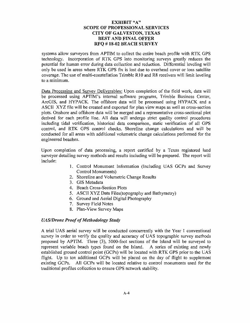
EXHIBIT "A" SCOPE OF PROFESSIONAL SERVICES
CITY OF GALVESTON, TEXAS BEST AND FINAL OFFER
RFQ # 18-02 BEACH SURVEY
systems allow surveyors from APTIM to collect the entire beach profile with RTK GPS technology. Incorporation of RTK GPS into monitoring surveys greatly reduces the potential for human error during data collection and reduction. Differential leveling will only be used in areas where RTK GPS fix is lost due to overhead cover or loss satellite coverage. The use of multi-constellation Trimble R l 0 and R8 receivers will limit leveling to a minimum.
Data Processing and Survey Deliverables: Upon completion of the field work, data will be processed using APTIM's internal software programs, Trimble Business Center, ArcGIS, and HYPACK. The offshore data will be processed using HYPACK and a ASCII XYZ file will be created and exported for plan view maps as well as cross-section plots. Onshore and offshore data will be merged and a representative cross-sectional plot derived for each profile line. All data will undergo strict quality control procedures including tidal verification, historical data comparison, static verification of all GPS control, and RTK GPS control checks. Shoreline change calculations and will be conducted for all areas with additional volumetric change calculations performed for the engineered beaches.
Upon completion of data processing, a report certified by a Texas registered land surveyor detailing survey methods and results including will be prepared. The report will include:
I. Control Monument Information (Including UAS GCPs and Survey Control Monuments)
2. Shoreline and Volumetric Change Results 3. GIS Metadata 4. Beach Cross-Section Plots 5. ASCII XYZ Data Files(topography and Bathymetry) 6. Ground and Aerial Digital Photography 7. Survey Field Notes 8. Plan-View Survey Maps
UAS/Drone Proof of Methodology Study
A trial U AS aerial survey will be conducted concurrently with the Year l conventional survey in order to verify the quality and accuracy of UAS topographic survey methods proposed by APTIM. Three (3), 5000-foot sections of the Island will be surveyed to represent variable beach types found on the Island. A series of existing and newly established ground control point (GCPs) will be located with RTK GPS prior to the UAS flight. Up to ten additional GCPs will be placed on the day of flight to supplement existing GCPs. All GCPs will be located relative to control monuments used for the traditional profiles collection to ensure GPS network stability.
A-4

EXHIBIT "A" SCOPE OF PROFESSIONAL SERVICES
CITY OF GALVESTON, TEXAS BEST AND FINAL OFFER
RFQ # 18-02 BEACH SURVEY
UAS data will be processed using ESRI ArcGIS products (or equivalent) for creation of a digital elevation model (DEM). Cross-section will be extracted from the DEM for comparison to the traditional RTK OPS profile collection. Results of the accuracy analysis and APTIM's recommendations for future surveys will be provided to the City in a letter report.
Years 2, 3, and 4 Surveying
In Years 2, 3, and 4, APTIM will conduct depth of closure surveys and wading depth surveys of the same beach profiles as described under the scope of work for Year 1. The depth of closure surveys will be conducted using the same methodology as described previously in this scope of professional services. Assuming the Proof of Methodology study conclusively determines that the UAS/Drone can be used to conduct the Wading Depth Surveys, the following methodology will be used to conduct those surveys in Years 2, 3, and 4.
UAS/Drone Wading Depth Surveys: APTIM will conduct wading depth surveys using UAS/Drone technology along Galveston Island between Stations 550+00 to 420+00, 50+00 to 30+00, 1460+00 to 1210+00 and 1090+00 to 570+00.
Several flights will be needed to collect the entire project area. Prior to all UAS flights, a RTK OPS survey of the GCPs and survey control monuments will be conducted following the control reconnaissance procedures described for the Year 1 Survey.
UAS data collection will be conducted using a OJI Phantom IV unmanned aircraft. Flights will be planned to maximize coverage per transect while maintaining the resolution needed to derive an accurate topography of the ground. All FAA procedures and rules according to Part 107 will be followed. UAS Data will be processed using ESRI ArcGIS tools for DEM creation and cross-section extraction. A cross-section will be extracted for all stations stated above.
In addition to UAS data collection, RTK OPS profiles will be collected at 5000' spacing for ground truthing and DEM validation. RTK OPS profile collection will follow the same methods as outlined in the Year 1 Survey procedures described above.
Data Processing and Survey Deliverables: Data processing will follow the same methods and deliverables included in the Year 1 Survey with the inclusion of the complete UAS flight as described above.
A-5

EXHIBIT "A" SCOPE OF PROFESSIONAL SERVICES
CITY OF GALVESTON, TEXAS BEST AND FINAL OFFER
RFQ # 18-02 BEACH SURVEY
SCHEDULE B - OPTIONAL SERVICES
Typically, coastal communities are eligible for public assistance funds for their beaches through Category B and Category G of the Public Assistance Program authorized by the Robert T. Stafford Disaster Relief and Emergency Assistance Act. Category B stipulates that if a natural or engineered beach has eroded to a point where a 5-year flood could damage improved property, cost-effective emergency protective measures on the beach that protect against damage from that flood are eligible. Eligible measures typically include the construction of emergency sand berms to protect against additional damage from a 5-year flood. Category G allows for beaches to be considered eligible facilities for Public Assistance funds under certain conditions. Both types of assistance require surveying to be conducted to determine the eligibility of a community to receive Public Assistance.
Post Storm Event Surveying (Category G Only) In the event that a storm impacts the City of Galveston beaches, and the City determines they wish to apply for Category G Public Assistance for the engineered beaches previously constructed (Historic Seawall Beach, Babe's Beach, Dellanera Beach), APTIM will conduct a post storm depth of closure survey of the profiles from Stations 410+00 to 60+00 and 20+00 to 1470+00, for a total of forty-four (44) profiles. APTIM will use the same methodology to conduct this survey as is described under Schedule A -Annual Surveys, Year I Surveys, Depth of Closure Surveys.
Contingency to Restore Control Points: APTIM will establish control monuments in the event that the existing survey control monuments are lost to the extent that the OPS network is compromised or provides insufficient coverage for the survey area.
Control will be established using Static OPS session methods tied to multiple National Geodetic Survey (NOS) Continually Operating Reference Stations (CORS). Multiple OPS receivers will be deployed simultaneously to log satellite observations on multiple control points. Observations will be logged so there is a minimum of 8 hours of overlapping observations for each receiver on each survey monument. A second set of observations will be collected using different receivers for redundant measurement and adjustment purposes.
Static observations will be processing using the NOS Online Positing User Service Projects (OPUS-Projects) utility. All processing will be conducted by an NOS trained OPUS-Projects manager. A processing report will be prepared including adjustment report and a final fully constrained coordinate solutions.
Please note this task is contingent on being onsite for a Post-Storm Survey. No travel or mobilization is included with this task.
A-6
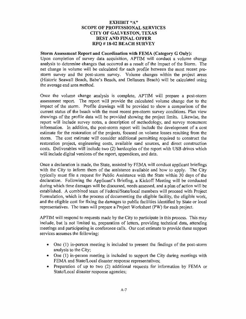
EXHIBIT "A" SCOPE OF PROFESSIONAL SERVICES
CITY OF GALVESTON, TEXAS BEST AND FINAL OFFER
RFQ # 18-02 BEACH SURVEY
Storm Assessment Report and Coordination with FEMA (Category G Only): Upon completion of survey data acquisition, APTIM will conduct a volume change analysis to determine changes that occurred as a result of the impact of the Storm. The net change in volume will be calculated for each profile between the most recent prestorm survey and the post-storm survey. Volume changes within the project areas (Historic Seawall Beach, Babe's Beach, and Dellanera Beach) will be calculated using the average end area method.
Once the volume change analysis is complete, APTIM will prepare a post-storm assessment report. The report will provide the calculated volume change due to the impact of the storm. Profile drawings will be provided to show a comparison of the current status of the beach with the most recent pre-storm survey conditions. Plan view drawings of the profile data will be provided showing the project limits. Likewise, the report will include survey notes, a description of methodology, and survey monument information. In addition, the post-storm report will include the development of a cost estimate for the restoration of the projects, focused on volume losses resulting from the storm. The cost estimate will consider additional permitting required to construct the restoration project, engineering costs, available sand sources, and direct construction costs. Deliverables will include two (2) hardcopies of the report with USB drives which will include digital versions of the report, appendices, and data.
Once a declaration is made, the State, assisted by FEMA will conduct applicant briefings with the City to inform them of the assistance available and how to apply. The City typically must file a request for Public Assistance with the State within 30 days of the declaration. Following the Applicant's Briefing, a Kickoff Meeting will be conducted during which time damages will be discussed, needs assessed, and a plan of action will be established. A combined team of Federal/State/local members will proceed with Project Formulation, which is the process of documenting the eligible facility, the eligible work, and the eligible cost for fixing the damages to public facilities identified by State or local representatives. The team will prepare a Project Worksheet (PW) for each project.
APTIM will respond to requests made by the City to participate in this process. This may include, but is not limited to, preparation of letters, providing technical data, attending meetings and participating in conference calls. Our cost estimate to provide these support services assumes the following:
• One (I) in-person meeting is included to present the findings of the post-storm analysis to the City;
• One (I) in-person meeting is included to support the City during meetings with FEMA and State/Local disaster response representatives;
• Preparation of up to two (2) additional requests for information by FEMA or State/Local disaster response agencies;
A-7

EXHIBIT "A" SCOPE OF PROFESSIONAL SERVICES
CITY OF GALVESTON, TEXAS BEST AND FINAL OFFER
RFQ # 18-02 BEACH SURVEY
• Participation in up to four ( 4) conference call meetings with City staff to discuss the project.
Post Storm Event Surveying (Category Band G): If the City determines it wishes to apply for both Categories B and G Public Assistance following a storm, APTIM will conduct a post storm depth of closure and wading depth survey along Galveston Island as described under Schedule A - Annual Surveys, Year 2, 3, and 4 Surveys. The methodology to be used will be the same as described under Schedule A -Annual Surveys, Year 2, 3, and 4 Surveys. The total number of surveys of each type will be forty-four (44) depth of closure surveys and ninety-six (96) wading depth surveys.
If necessary, APTIM will establish control monuments as described under Schedule B -Optional Services, Contingency to Restore Control Points.
Upon completion of survey data acquisition, APTIM will conduct a volume change analysis to determine changes that occurred as a result of the impact of the Storm. The net change in volume will be calculated for each profile along the engineered beaches as previously described. For Category B damages, volume changes will focus on volume lost to the dune system and elevation along the island. Upon completion of post storm analyses, APTIM will prepare a post-storm assessment report in a similar matter described under Schedule B - Optional Services, Storm Assessment Report and FEMA Coordination (Category G Only). The cost included in Exhibit B- Breakdown of Costs, for Storm Assessment Report and FEMA Coordination (Category B and G) reflects additional efforts to quantify dune losses outside of the engineered beach sections, additional cost estimating for potential dune repair projects, and an increase in coordination with FEMA to account for Category B Public Assistance.
SCHEDULE C - BEACH MAINTENANCE PLAN
Under 44 CPR 206.2260)(2), work on improved beaches may be eligible for FEMA Public Assistance (PA) if the project is impacted by a presidentially declared disaster or emergency. Work is eligible under the following conditions: I) the beach is not a federally constructed shoreline under the specific authority of USA CE; 2) the beach was constructed by the placement of imported sand-of proper grain size-to a designed elevation, width, and slope; and 3) that the applicant has established and adhered to a maintenance program involving periodic renourishment with imported sand to preserve the original design.
The latest FEMA guidance further establishes that placement of sand under the following circumstances does not meet this requirement:
A-8

EXHIBIT "A" SCOPE OF PROFESSIONAL SERVICES
CITY OF GALVESTON, TEXAS BEST AND FINAL OFFER
RFQ # 18-02 BEACH SURVEY
Emergency or "one-time" nourishment, even if to a design Emergency or "as needed" renourishment when the beach has eroded to a critical condition where all of the original nourishment is gone Partial renourishment or "hot spot" nourishments Renourishment using material from a channel maintenance project, because dredge spoils do not meet compatibility design criteria and the amount placed is dependent on the amount dredged, not the beach design.
APTIM believes that the City can best position itself to be eligible for FEMA public assistance under Category G in the event of future storm impacts, through the development ofa Beach Maintenance Plan. This belief is based on APTIM's long history assisting clients with successfully obtaining FEMA reimbursement for repairs to beach nourishment projects.
APTIM will develop a Beach Maintenance Plan for the City, in order to best position the community for potential Public Assistance funding following a presidentially declared disaster. The maintenance plan will clearly define the beach fill design, document the asbuilt volume of sand placed, and document the plan for maintaining the project in the future including re-nourishment thresholds and availability of sand sources sufficient to conduct renourishment.
APTIM will utilize previous design documents for the engineered beaches, namely Historic Seawall Beach, Babes Beach, and Dellanera Beach to document the beach fill projects constructed to date. This will include as-built volumes placed during construction. The previous design documents will also be used to document the design criteria for the beach. Furthermore, APTIM will use historic beach profile data to establish erosion rates that will be used to determine the volume of advanced fill needed for future maintenance events.
FEMA guidance asserts that renourishment using material from a channel maintenance project is ineligible because dredge spoils do not meet compatibility design criteria and the amount placed is dependent on the amount dredged, not the beach design. The development of the Beach Maintenance Plan, will include an analysis to determine the sediment compatibility between potential sand sources and the existing beaches.
APTIM will collect eleven (1 l) samples from specifically defined locations along nine (9) profiles. Six (6) profiles will be taken within the engineered beach projects and three (3) will be taken adjacent to the engineered beach projects. On each profile, five (5) samples will be collected landward of the mean low water (MLW) contour, five (5) samples will be collected seaward of the MLW contour, and one (I) additional sample at the ML W line for a total of eleven ( 11).
A-9

EXHIBIT "A" SCOPE OF PROFESSIONAL SERVICES
CITY OF GALVESTON, TEXAS BEST AND FINAL OFFER
RFQ # 18-02 BEACH SURVEY
The sediment samples collected along each profile will be individually analyzed to determine color and grain size distribution. During sieve analysis, the wet, dry and washed Munsell colors will be noted. Sieve analysis of the sediment samples will be performed in accordance with the American Society for Testing and Materials (ASTM) Standard Methods Designation D 422-63 for particle size analysis of soils. This method covers the quantitative determination of the distribution of sand size particles. For sediment finer than the No. 230 sieve ( 4.0 phi) the ASTM Standard Test Method, Designation D I I 40-00 will be followed. Weights retained on each sieve will be recorded cumulatively. Grain size results will be entered into the g!NT® software program, which computes the mean and median grain size, sorting, silt/clay percentages for each sample using the moment method.
Upon completion of individual sediment analysis, composite sediment characteristics will be calculated for each profile as well as for each project area. APTIM will obtain information on sediment characteristics for the channel borrow sources previously used to construct the Historic Seawall Beach, Babe's Beach, and Dellanera Park Beach projects from the City and/or its engineer. APTIM will obtain information on sediment characteristics for offshore sand resources from reports developed by APTIM (formerly CPE) in 2007, while working under contract for Galveston and Jefferson Counties. Comparison tables will be provided to show existing beach and borrow source mean grain size, median grain size, sorting, color, and percent fine grained material, which is defined as sediments passing through the No. 230 sieve ( 4.0 phi). Additional deliverables associated with the sediment compatibility analysis will include maps showing the locations of samples and borrow sources as well as granularmetric reports and grain size distribution curves for each sample.
APTIM will prepare a Beach Maintenance Plan to serve as documentation that the City's beach projects meet the PA criteria established by FEMA. This document can then be provided to FEMA if a project is impacted by a presidentially declared disaster. The Beach Maintenance Plan will include a description of the project design, construction activities to date, anticipated volume and cost for maintenance, schedule of maintenance and the monitoring protocols being employed by the City. APTIM will coordinate with the City's staff to identify current and future funding sources and document these in the Beach Maintenance Plan. The Beach Maintenance Plan will also identify supplemental borrow sites available for future projects in order to clearly establish the fact that nourishment of the projects is not dependent on the amount of sand dredged for channel navigation maintenance.
Barring any unforeseen issues, the Beach Maintenance Plan will be delivered to the City ninety (90) days following the collection of beach profile survey data and sediment samples. This schedule is contingent on the City providing the necessary sediment characteristic and as-built data for the Historic Seawall Beach, Babe's Beach, and Dellanera Beach projects in a timely manner. The Beach Maintenance Plan will be
A-IO

EXHIBIT "A" SCOPE OF PROFESSIONAL SERVICES
CITY OF GALVESTON, TEXAS BEST AND FINAL OFFER
RFQ # 18-02 BEACH SURVEY
developed in a way consistent with guidance provided by FEMA under Disaster Assistance Fact Sheet 9580.8 issued in October 2009 by Elizabeth Zimmerman. Upon receipt of comments from the City, APTIM will address relevant comments and provide a Final version of the Beach Maintenance Plan. Two (2) hardcopies and two (2) digital copies of the Final Beach Maintenance Plan will be provided to the City at the time of completion.
SCHEDULE D - SHORELINE CHANGE ANALYSIS
This section has been deleted in response to the email from Susan Serrano dated September 4, 2018.
SCHEDULE E - GIS DELIVERABLES
All GIS deliverables specifically described in this proposal will be provided in a format that meets the requested data formats specified in the City's request for BAFO dated August 7, 2018. Specifically, GIS data files will use ArcGIS metadata format and include the following information:
• Name & alias • Data tags • Description of the data - Summary & detailed description, specific to the feature
class • Collection methods and equipment used - how and when data was collected, by
whom, and other pertinent information • Description of codes and attribute field information, field aliases • Scale and spatial reference • Source of the data • Contact information of the person/company who collected and prepared the data • Statement of issues with the data, appropriate uses, or data sensitivity (how the
data should/shouldn't be used).
No additional cost associated with providing deliverables in this format is required, as our costs for Schedule A - C incorporate the necessary efforts required to provide data in these formats.
The information contained in this proposal is confidential commercial information and shall not be used or disclosed, except for evaluation purposes, provided that if a contract is awarded to APTIM as a result of or in connection with the submission of this proposal, the requester shall have the right to use or disclose the data to the extent provided in the contract. This restriction does not limit the requester's right to use or disclose any technical data obtained from another source without restriction.
A-11

EXHIBITB: BREAKDOWN OF COSTS
CITY OF GALVESTON, TEXAS BEST AND FINAL OFFER
RFQ # 18-02 BEACH SURVEY
Table I. Breakdown of the costs associated with Schedule A, B, C, D, and E.
Schedule DESCRIPTION
A. Annual Surveys
Year 1 Surveying
Depth of Closure Surveys for Engineered Beaches (44 Profiles
RTK GPS Wading Depth Surveys (96 Profiles)
UAS/Drone Proof of Methodology Study
Year 2 Surveying
Depth of Closure Surveys for Engineered Beaches
Wading Depth Surveys (UAS and 20 Profiles)
Year 3 Surveying
Depth of Closure Surveys for Engineered Beaches
Wading Depth Surveys (UAS and 20 Profiles)
Year 4 Surveying
Depth of Closure Surveys for Engineered Beaches
Wading Depth Surveys (UAS)
B. Optional Services
Post Storm Event Surveying (Category G Only)
Depth of Closure Surveys for Engineered Beaches
Contingency Cost to Restore Control Points (up to Four Control Points-2 Days)
Storm Assessment Report & Coordination with FEMA
Post Storm Event Surveying (Category Band G)
Depth of Closure Surveys for Engineered Beaches
Wading Depth Surveys (UAS)
Contingency Cost to Restore Control Points (up to Four Control Points-2 Days)
Storm Assessment Report & Coordination with FEMA
c. Beach Maintenance Plan - Optional
D. Shoreline Change Analysis (Deleted From BAFO at City Request)
E. GIS Deliverables (Included with Survey Deliverables)
B - I
Cost
$55,230
$54,271
$12,167
$55,230
$47,919
$55,230
$47,919
$55,230
$47,919
$55,230
$6,497
$29,552
$55,230
$47,919
$6,497
$41,027
$47,600
N/A
N/A

EXHIBITC: LIST OF DELIVERABLES
CITY OF GALVESTON, TEXAS BEST AND FINAL OFFER
RFQ# 18-02 BEACH SURVEY
The following items have been identified by APTIM as deliverables to the City for the completion of this scope of services.
• Monthly Progress Reports;
• Annual Survey Report/Post-Storm Survey Report;
• UAS/Drone Proof of Methodology Study Letter Report;
• Storm Assessment Report - Optional
• Beach Maintenance Plan - Optional
A detailed description and an individual schedule for each deliverable are provided below.
Monthly Progress Reports: APTIM will provide a I page summary of the project status via e-mail approximately every 30 days during the course of the anticipated 4 year contract period. The letter will describe activities completed throughout the month and update the anticipated schedule of milestones as appropriate.
Annual Survey Report/Post-Storm Survey Report: Upon completion of data processing, a report certified by a Texas registered land surveyor detailing survey methods and results will be prepared and provided to the City. The report will include the following items.
I. Control Monument Information (Including UAS GCPs and Survey Control Monuments)
2. Shoreline and Volumetric Change Results 3. Federally compliant metadata 4. Beach Cross-section Plots 5. ASCII XYZ files 6. Ground and Aerial digital photography 7. Survey Field notes 8. Plan-view survey maps
All GIS deliverables will include the requested metadata as described in Exhibit A, under Schedule E.
Barring any unforeseen circumstances, the survey report will be provided within 90 days following completion of survey data acquisition.
UAS/Drone Proof of Methodology Study Letter Report: Results of the accuracy analysis and APTIM's recommendations for future surveys will be provided to the City in a letter report. The deliverable will include 2 hard copies of the letter report with USB drives, which will include
c - 1
EXHIBITC: LIST OF DELIVERABLES
CITY OF GALVESTON, TEXAS BEST AND FINAL OFFER
RFQ# 18-02 BEACH SURVEY
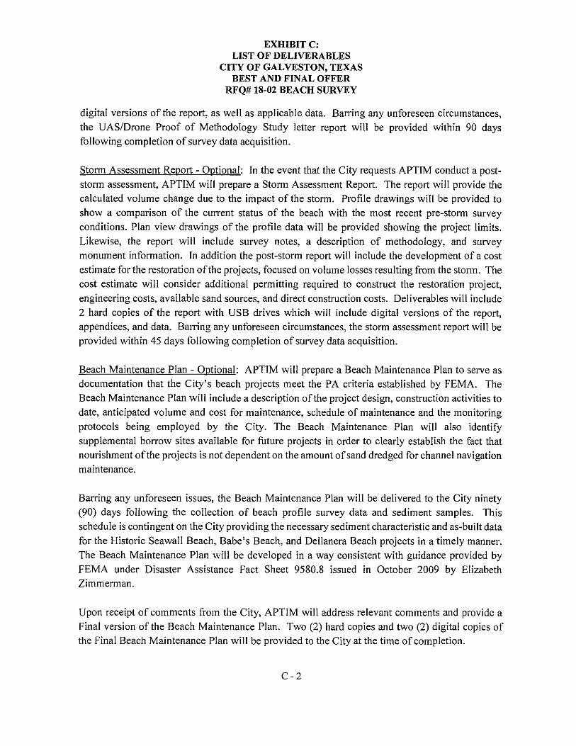
digital versions of the report, as well as applicable data. Barring any unforeseen circumstances, the UAS/Drone Proof of Methodology Study letter report will be provided within 90 days following completion of survey data acquisition.
Storm Assessment Report - Optional: In the event that the City requests APTIM conduct a poststorm assessment, APTIM will prepare a Storm Assessment Report. The report will provide the calculated volume change due to the impact of the storm. Profile drawings will be provided to show a comparison of the current status of the beach with the most recent pre-storm survey conditions. Plan view drawings of the profile data will be provided showing the project limits. Likewise, the report will include survey notes, a description of methodology, and survey monument information. In addition the post-storm report will include the development of a cost estimate for the restoration of the projects, focused on volume losses resulting from the storm. The cost estimate will consider additional permitting required to construct the restoration project, engineering costs, available sand sources, and direct construction costs. Deliverables will include 2 hard copies of the report with USB drives which will include digital versions of the report, appendices, and data. Barring any unforeseen circumstances, the storm assessment report will be provided within 45 days following completion of survey data acquisition.
Beach Maintenance Plan - Optional: APTIM will prepare a Beach Maintenance Plan to serve as documentation that the City's beach projects meet the PA criteria established by FEMA. The Beach Maintenance Plan will include a description of the project design, construction activities to date, anticipated volume and cost for maintenance, schedule of maintenance and the monitoring protocols being employed by the City. The Beach Maintenance Plan will also identify supplemental borrow sites available for future projects in order to clearly establish the fact that nourishment of the projects is not dependent on the amount of sand dredged for channel navigation maintenance.
Barring any unforeseen issues, the Beach Maintenance Plan will be delivered to the City ninety (90) days following the collection of beach profile survey data and sediment samples. This schedule is contingent on the City providing the necessary sediment characteristic and as-built data for the Historic Seawall Beach, Babe's Beach, and Dellanera Beach projects in a timely manner. The Beach Maintenance Plan will be developed in a way consistent with guidance provided by FEMA under Disaster Assistance Fact Sheet 9580.8 issued in October 2009 by Elizabeth Zimmerman.
Upon receipt of comments from the City, APTIM will address relevant comments and provide a Final version of the Beach Maintenance Plan. Two (2) hard copies and two (2) digital copies of the Final Beach Maintenance Plan will be provided to the City at the time of completion.
C-2