agenda ordinary meeting of council … · wednesday 24 august 2016 in the ... or crossing opening...
TRANSCRIPT

AGENDA
of the
ORDINARY MEETING OF COUNCIL
to be held on
WEDNESDAY 24 AUGUST 2016
in the
YEA CHAMBERS
commencing at
6.00 pm
Ordinary Meeting of Council Agenda - 1 - 24 August 2016
INDEX
1. PRAYER, OATH & RECONCILIATION STATEMENT .......................................... 2
2. APOLOGIES AND REQUESTS FOR LEAVE OF ABSENCE ............................... 2
3. CONFIRMATION OF MINUTES ............................................................................. 2
4. DISCLOSURES OF INTEREST OR CONFLICT OF INTEREST ........................... 2
5. PUBLIC PARTICIPATION TIME ............................................................................ 2
5.1 Questions of Council ......................................................................................................... 2 5.2 Open Forum ...................................................................................................................... 2 5.3 Petitioners Speaking to Petitions ....................................................................................... 2
6. OFFICER REPORTS .............................................................................................. 3
6.1 2015/242 – Extons Road Dwelling and Accommodation ................................................... 3 6.2 2016/18 – 140 High Street Subdivision ........................................................................... 10 6.3 Proposed Rezoning and Subdivision – Yarck – C58 ....................................................... 17 6.4 End of Year Report – Capital Works Program 2015/2016 ............................................... 22
7. SEALING REGISTER .......................................................................................... 29
8. COUNCILLOR PORTFOLIO REPORTS .............................................................. 30
8.1 Land Use Planning Portfolio ............................................................................................ 30 8.2 Economic Development Portfolio .................................................................................... 30 8.3 Infrastructure and Waste Portfolio ................................................................................... 30 8.4 Corporate and customer Services Portfolio ..................................................................... 30 8.5 Natural Environment & Climate Change Portfolio ............................................................ 30 8.6 Mayor and Delegated Committee Reports ...................................................................... 31 8.7 General Business ............................................................................................................ 31
9. MATTERS DEFERRED FROM PREVIOUS MEETING ....................................... 31
10. MOTIONS FOR WHICH NOTICE HAS PREVIOUSLY BEEN GIVEN ................. 31
11. ASSEMBLIES OF COUNCILLORS ..................................................................... 31
12. URGENT BUSINESS ........................................................................................... 32
13. CONFIDENTIAL ITEMS ....................................................................................... 32
Ordinary Meeting of Council Agenda - 2 - 24 August 2016
1. PRAYER, OATH & RECONCILIATION STATEMENT
2. APOLOGIES AND REQUESTS FOR LEAVE OF ABSENCE
REF: SF/306
3. CONFIRMATION OF MINUTES
Minutes of the Ordinary Meeting of Council held on 27 July 2016 Officer Recommendation: That the Minutes of the Ordinary Meeting of Council held on 27 July 2016 be confirmed. Minutes of the Special Meeting of Council held on 27 July 2016 Officer Recommendation: That the Minutes of the Special Meeting of Council held on 27 July 2016 be confirmed. Minutes of the Special Meeting of Council held on 3 August 2016 Officer Recommendation: That the Minutes of the Special Meeting of Council held on 3 August 2016 be confirmed.
4. DISCLOSURES OF INTEREST OR CONFLICT OF INTEREST
REF: SF/783
5. PUBLIC PARTICIPATION TIME
5.1 QUESTIONS OF COUNCIL
5.2 OPEN FORUM
REF: SF/130
5.3 PETITIONERS SPEAKING TO PETITIONS
REF: SF/132
Ordinary Meeting of Council Agenda - 3 - 24 August 2016
6. OFFICER REPORTS
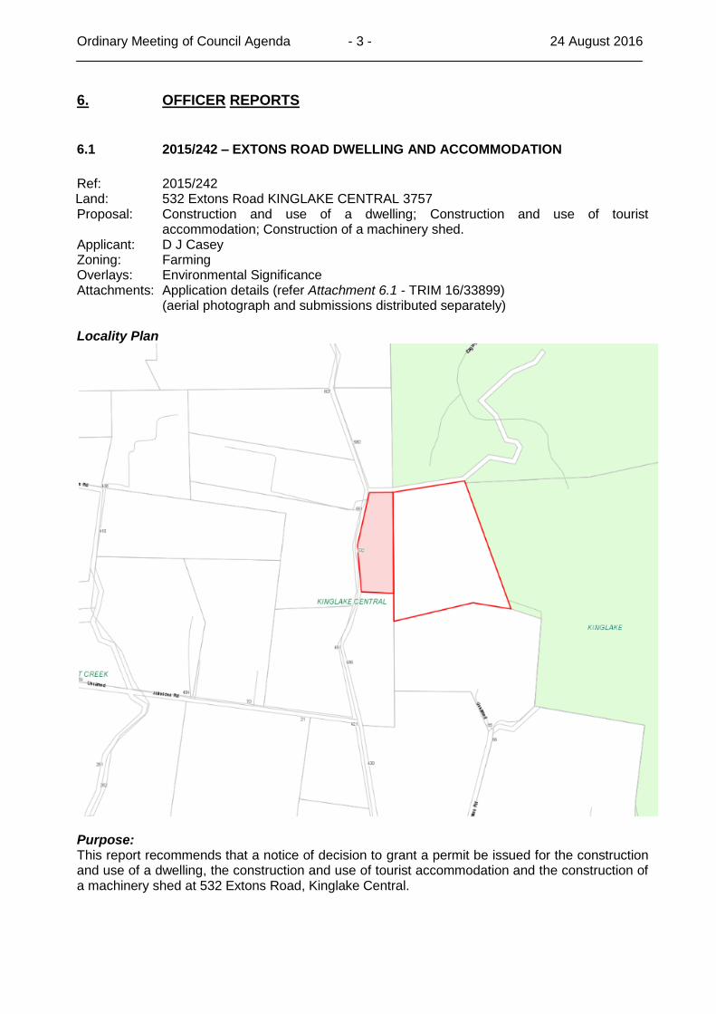
6.1 2015/242 – EXTONS ROAD DWELLING AND ACCOMMODATION
Ref: 2015/242 Land: 532 Extons Road KINGLAKE CENTRAL 3757 Proposal: Construction and use of a dwelling; Construction and use of tourist
accommodation; Construction of a machinery shed. Applicant: D J Casey Zoning: Farming Overlays: Environmental Significance Attachments: Application details (refer Attachment 6.1 - TRIM 16/33899)
(aerial photograph and submissions distributed separately) Locality Plan
Purpose: This report recommends that a notice of decision to grant a permit be issued for the construction and use of a dwelling, the construction and use of tourist accommodation and the construction of a machinery shed at 532 Extons Road, Kinglake Central.
Ordinary Meeting of Council Agenda - 4 - 24 August 2016
Officer Recommendation: That Council issue notice of decision to grant a permit for the construction and use of a dwelling, the construction and use of tourist accommodation and the construction of a machinery shed at 532 Extons Road, Kinglake Central 3757 (Lot 1, LP 61248 and C/A: 8, Parish of Billian), subject to the following conditions:
1. The layout of the site and the size and type of the proposed buildings and works, including the materials of construction, as shown on the endorsed plan shall not be altered or modified without the consent in writing of the Responsible Authority.
2. This permit shall expire if the development hereby permitted is not completed and the use commenced within two (2) years of the date hereof, or any extension of such period the Responsible Authority may allow in writing. A request for an extension of time may be made before or within six (6) months after the permit expiry date, where the use or development allowed by the permit has not yet commenced, or within 12 months after the permit expiry date, where the development allowed by the permit lawfully commenced before the permit expired.
3. All external cladding including the roof and trims of the building allowed must be coloured or painted in muted shades of green, brown or charcoal, or in a colour approved in writing by the Responsible Authority.
4. The shed hereby permitted shall not be used for human habitation, and must not contain facilities that could be used for cooking, eating or sleeping.
5. All sewage and sullage waters shall be treated in accordance with the requirements of the Environment Protection Authority and the Council. All effluent shall be disposed of and contained within the curtilage of the land and shall not discharge directly or indirectly to an adjoining property, street or any water course, water storage or dam. Sufficient land shall be set aside and kept available for the purpose of effluent disposal.
6. Prior to the commencement of any works, including site works, the applicant shall obtain a septic tank permit from Council.
7. Prior to commencing construction a suitable prepared engineering plan detailing the proposed driveway, earthworks and drainage, including the abovementioned erosion and sediment control measures must be submitted to the Responsible Authority and receive its endorsement.
8. All stormwater and surface water discharging from the building and works must be conveyed to a point of discharge, approved by the relevant authority. No stormwater discharge from downpipes or overflow from storage tank and surface water shall be directed or caused to be directed in a concentrated form that will cause erosion and or adverse affects within the site or to adjoining land or properties.
9. The approved works must not cut off natural drainage to adjacent properties.
10. Vehicular crossing(s) must be constructed to the road to suit the proposed driveway(s) to the satisfaction of the responsible authority and any existing crossing or crossing opening must be removed and replaced with nature strip to the satisfaction of the Responsible Authority. Construction of new vehicular crossing(s) must comply with the SD 250 of IDM for New Industrial Vehicle Crossing Detail.
11. All refuse and rubbish associated with the use allowed must be removed from the area at least once weekly, and more often if required by the Responsible Authority.
12. The use or development hereby permitted shall not cause nuisance or injury to, or prejudicially affect the amenity of the locality, by reason of the transportation of materials, goods and commodities to and from the land, the appearance of any building, works, or materials on the land, the emission of noise, vibration, smell,
Ordinary Meeting of Council Agenda - 5 - 24 August 2016
fumes, smoke, vapour, steam soot, ash, dust, waste water, waste products, grit, oil or the presence of vermin or otherwise.
13. The subject land must be kept neat and tidy at all times and its appearance must not, in the opinion of the Responsible Authority, adversely affect the amenity of the locality.
14. Prior to the commencement of any buildings or works three (3) copies of a landscape plan or plans shall be submitted and approved by the Responsible Authority. Such plans must show an area to the west of the proposed accommodation building to be set aside for landscaping, and must detail trees and shrubs to be planted in a manner to create an effective visual screen to the dwelling at 551 Extons Road, Kinglake Central. When approved these plans will be endorsed and will form part of the permit.
15. Before the start of the use allowed, an area to the west of the proposed accommodation building set aside for landscaping, as shown on the endorsed plan, must be planted with trees and shrubs in accordance with the plan. This area must then be maintained to the satisfaction of the Responsible Authority, and must not be used for any other purpose except with the prior written approval of the Responsible Authority.
16. On the construction of the dwelling a combined water system shall be provided to accommodate a total minimum of 55,000 litres of which 45,000 litres shall be for domestic purposes and 10,000 litres for fire fighting purposes, the latter being in the lower portion of the tank, or in a separate tank. All outlets from the lower tank shall be fitted with 64 millimetres 3 thread/25 millimetres x 50 millimetres nominal bore British Standard Pipe (BSP), round male coupling, and fire brigade vehicles must be able to get to within four metres of the coupling.
17. Should the tank not be elevated sufficiently to provide adequate pressure at hose points around the dwelling, then a 50 millimetres centrifugal water pump shall be provided, driven by an internal combustion engine.
18. Prior to the commencement of works, Lot 1 LP 61248, and Crown Allotment 8, Parish of Billian, must be consolidated into one title.
Country Fire Authority (CFA) 19. The Bushfire Management Plan (prepared by BAL Assessments, drawing no. Bushfire
Management Plan – 532 Extons Road Kinglake Central – Shed, Main Residence, Guest Residence – Version 3, dated 07/07/2016) must be endorsed to form part of the permit and must not be altered unless otherwise agreed in writing by the CFA and the Responsible Authority.
Notations: 1. This permit does not authorise the commencement of any building construction
works. Before any such development may commence, the applicant must apply for and obtain appropriate building approval.
Proposal: An application was received for the construction and use of a dwelling and machinery shed, and for the construction and use of a tourist accommodation unit, on the property at 532 Extons Road, Kinglake Central. The property is made up of two parcels of land; Crown Allotment 8 at 21.34 hectares and Lot 1, LP61248, being 6.49 hectares, making a total of 27.83 hectares in total. The proposal is to run cattle (10 to 20 cows) and cut hay on the cleared agricultural land, and to have a small tourist accommodation cottage for short term rental. The application was required to complete a Bushfire Management Statement to address the bushfire risk on the property.
Ordinary Meeting of Council Agenda - 6 - 24 August 2016
The Land & Surroundings: The subject land is approximately 27.83 hectares in size and is generally clear. The property is bounded by public land to the north and east and by private land to the west and south. The surrounding land is generally heavily vegetated, with a dwelling on the western side of Extons Road, opposite the proposed tourist accommodation. Properties in the surrounding area are generally of a similar size to the subject land, and this property has natural buffers due to the vegetation in the area. There are some properties with less vegetation in the general area, and these are used for a variety of farming purposes. Referrals: The application was referred internally to Council’s Development Engineer and Environmental Health Unit, who had no objections to the application. The application was also referred to the Country Fire Authority, who had no objections subject to conditions. Consultation: The application was notified to nearby and adjoining owners, with one submission received. The submitter wants the tourist accommodation to be located at least 150 metres from the dwelling on the western side of Extons Road. The applicant had originally placed it 35 metres from the road reserve, but has relocated it to address the submitters concerns to be 60 metres from the front boundary (approximately 114 metres from the neighbours dwelling). This has not satisfied the concerns, and the applicant does not wish to move it any further back on the property. Council officers are satisfied that the distance of 114 metres is adequate.
Newspaper / Other Publishing/Consultation Date(s)
Consultation: Sign on site 10 May 2016
Mail out: Nearby and adjoining owners
10 May 2016
Planning Considerations: The proposal is for a combined dwelling and tourist accommodation development, to support the agricultural use of the land for cattle grazing and hay production. The whole of the property is approximately 27 hectares in size, made up of two parcels. As it is currently structured there is a potential for an application for dwellings on each of the two allotments. The proposal has been framed to provide its agricultural potential in terms of the whole of the land, being the two separate parcels being utilised together, so that any permit that is issued for this proposal would contain a condition that would require that both allotments be consolidated into one title. The determination of whether the nexus between the proposed agricultural use and the need for a dwelling must be made in context with the land itself, its own capacity, as well as how the surrounding land is utilised. In this application a Farm Management Plan was provided with the application that detailed the proposed area for grazing to be approximately 24 hectares, with 1.6 hectares on the property covered with native bushland, with a domestic zone of approximately 1 acre. The property is supplied with three separate dams, two of which are spring fed, and are able to provide a permanent water source for stock. The land is currently underutilised and the owner intends to undertake pasture renovation and repair the fencing to enable the containment of stock. The shed proposed will be used for machinery and hay storage to support stock. The soil type is a rich volcanic soil, the subject site is only slightly undulating, and has excellent water supply. The use for grazing is an increased use on current practices and the location of the proposed buildings is such that more intensive horticultural practices can still be undertaken that would utilise the capacity of the land based on soil types and water access. The submission raised concerns with the location of the proposed tourist accommodation. Upon assessment of this concern, Council officers are satisfied that the proposed location will not be detrimental to the dwelling to the west.
Ordinary Meeting of Council Agenda - 7 - 24 August 2016
The properties in the surrounding area are generally of a similar size, with single dwellings and associated shedding on a lot of the properties. There is a significant amount of remnant vegetation on the private land to the south and west, with heavily vegetated public land to the north and east. With consideration for the existing use of the surrounding land, the construction and use of a dwelling, supported by tourist accommodation, will not be detrimental to the ability of the subject land and the surrounding land to be used for farming purposes. Conclusion: When considering the characteristics of the area, including the sites proximity to existing dwellings and public land, the combined proposal allows for a farming use to be supported by a dwelling, with a supplementary income from tourist accommodation. The remnant native vegetation on adjoining land creates natural limitations for these adjoining properties to be used for agriculture, and this further supports the use of the land for a dwelling as it will not have a detrimental impact on the ability of nearby properties to farm, and should be supported. Legal/Policy Issues: 11.10 Hume Regional Growth
Objective: To develop a more diverse regional economy while managing and enhancing key regional economic assets.
Strategies:
Facilitate rural tourism activities that support agricultural enterprises such as cellar door and farm gate sales and accommodation in appropriate locations.
14.01 Agriculture
Objective: To protect productive farmland which is of strategic significance in the local or regional context.
Strategies:
Ensure that the state’s agricultural land base is protected from the unplanned loss of productive agricultural land due to permanent changes of use.
In considering a proposal to develop agricultural land, the following factors must be considered:
o The desirability and impacts of removing the land from primary production, given its agricultural productivity.
o The impacts of the proposed subdivision on the continuation of primary production on adjacent land, with particular regard to land values and to the viability of infrastructure for such production.
o The compatibility between the proposed or likely development and the existing uses of the surrounding land.
Local Planning Policy Framework 21.01 Context
Issues:
Agriculture: the recognition and protection of the Goulburn River Valley and other areas as high quality agricultural land, with further opportunities to diversify and value add to agriculture.
21.03-2 Agriculture
Context:
The Kinglake Ranges and Toolangi areas have high quality soils and agricultural value.
Ordinary Meeting of Council Agenda - 8 - 24 August 2016
Agricultural land is under increasing pressure for conversion into non-agricultural uses. It is important that any new uses, subdivisions or developments in rural areas do not reduce the productive capacity of agricultural land and the capability of existing agricultural, aquaculture, horticultural or timber productions uses to continue.
Issues:
Agriculture has economic and strategic significance for the municipality and has potential for continued expansion.
The protection of agricultural land is necessary to support future growth of the agricultural sector and the diversification of agricultural activities.
Potential for housing to lead to incremental loss of productive agricultural land.
Potential for use of agricultural land for non-agricultural or rural-living purposes to conflict with established or future agricultural and horticultural land uses.
Strategies:
Develop the agricultural economic base through the attraction of value adding agricultural industries.
Ensure that the use and development of rural land is compatible with surrounding agricultural activities.
Ensure that agricultural land is not developed for primarily residential purposes. 21.03-3 Tourism
Issues:
Need to enhance tourism in the municipality, promoting the proximity to Melbourne and the natural environment.
The need for provision of a wide range of tourism accommodation options, including backpacker accommodation and boutique luxury accommodation.
Need for rebuilding of visitor accommodation, attractions and visitor facilities in areas impacted by the 2009 bushfires.
Strategies:
Support and grow tourism that builds upon the strengths of and is linked to the natural environment.
Facilitate development of new tourism accommodation options and conference centres.
Encourage small creative enterprises in tourism, creative arts, home-based businesses, overnight visitor accommodation and farm enterprises/markets that showcase local produce.
Zoning 35.07 Farming Zone
Purpose:
To provide for the use of the land for agriculture
To encourage the retention of productive agricultural land
To ensure that non-agricultural uses, including dwellings, do not adversely affect the use of land for agriculture.
Ordinary Meeting of Council Agenda - 9 - 24 August 2016
To encourage the retention of employment and population to support rural communities.
Decision Guidelines:
General Issues
How the use or development relates to sustainable land management.
Whether the site is suitable for the use or development and whether the proposal is compatible with adjoining and nearby land uses.
Agricultural issues and the impacts from non-agricultural uses
Whether the use or development will support and enhance agricultural production.
Whether the use or development will permanently remove land from agricultural production.
The potential for the development to limit the operation and expansion of adjoining and nearby agricultural uses.
The capacity of the site to sustain the agricultural use
Dwelling Issues
Whether the dwelling will be adversely affected by agricultural activities on adjacent and nearby land due to dust, noise, odour, use of chemicals and farm machinery, traffic and hours of operation.
Whether the dwelling will adversely affect the operation and expansion of adjoining and nearby agricultural uses.
The potential for the proposal to lead to concentration or proliferation of dwellings in the area and the impact of this use on the land for agriculture.
Design and Siting Issues
The need to locate buildings in one area to avoid any adverse impacts on surrounding agricultural uses and to minimise the loss of productive agricultural land.
A planning permit is required for a dwelling and tourist accommodation in the Farming Zone on a lot of less than 40 hectares.
Overlays 42.01 Environmental Significance Overlay
Environmental Objective to be achieved:
Protect high quality agricultural land because of its versatility, productivity and ability to sustain a wide range of agricultural uses without degradation.
Protect the potential production from high quality agricultural land.
Prevent the unsustainable development of high quality agricultural land that may result in the loss of the quantity or quality of the land and limit the full productive potential of land.
Prevent the conversion of high quality agricultural land to non soil based development.
Decision Guidelines:
Maintain the productive potential of high quality agricultural land.
Ordinary Meeting of Council Agenda - 10 - 24 August 2016
Consider the suitability of high quality agricultural land in the assessment of development proposals.
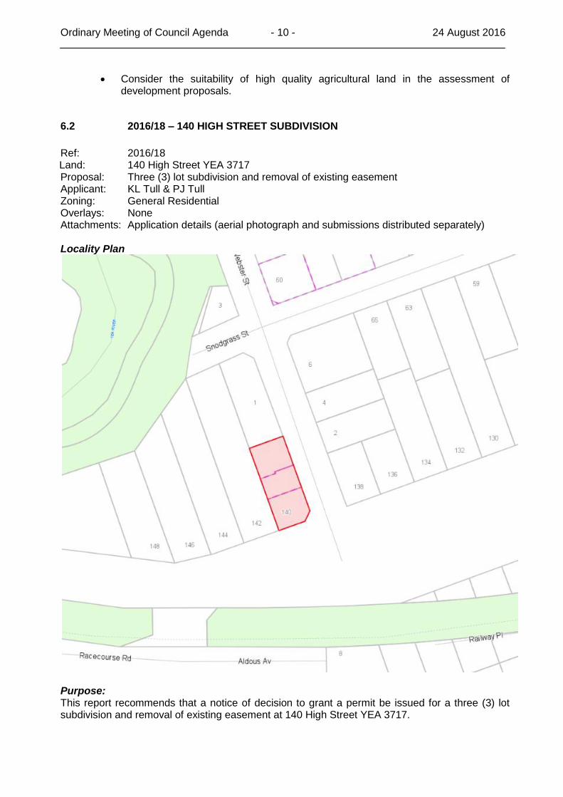
6.2 2016/18 – 140 HIGH STREET SUBDIVISION
Ref: 2016/18 Land: 140 High Street YEA 3717 Proposal: Three (3) lot subdivision and removal of existing easement Applicant: KL Tull & PJ Tull Zoning: General Residential Overlays: None Attachments: Application details (aerial photograph and submissions distributed separately) Locality Plan
Purpose: This report recommends that a notice of decision to grant a permit be issued for a three (3) lot subdivision and removal of existing easement at 140 High Street YEA 3717.
Ordinary Meeting of Council Agenda - 11 - 24 August 2016
Officer Recommendation: That Council issue a notice of decision to grant a permit for a three (3) lot subdivision and removal of existing easement at 140 High Street, Yea 3717 (LOT: 1 LP: 96556, Parish of Yea), subject to the following conditions:
1. This permit shall expire if all stages of the plan of subdivision hereby permitted are not certified within two (2) years of the date hereof or any extension of such period, the Responsible Authority may allow in writing on an application made before or within six (6) months after such expiry.
2. The subdivision must be in accordance with the endorsed plan. This endorsed plan can only be altered or modified with the prior written approval of the Responsible Authority, or to comply with statutory requirements.
3. The owner of the land must enter into agreements with the relevant authorities for the provision of water supply, drainage, sewerage facilities, electricity and gas services to each lot shown on the endorsed plan in accordance with the authority’s requirements and relevant legislation at the time.
4. All existing and proposed easements and sites for existing or required utility services and roads on the land must be set aside in the plan of subdivision submitted for certification in favour of the relevant authority for which the easement or site is to be created.
5. The plan of subdivision submitted for certification under the Subdivision Act 1988 must be referred to the relevant authority in accordance with Section 8 of that Act.
6. The owner of the land must enter into an agreement with:
A telecommunications network or service provider for the provision of telecommunications services to each lot shown on the endorsed plan in accordance with the provider’s requirements and relevant legislation at the time; and
A suitably qualified person for the provision of fibre ready telecommunications facilities to each lot shown on the endorsed plan in accordance with any industry specifications or any standards set by the Australian Communications and Media Authority, unless the applicant can demonstrate that the land is in an area where the National Broadband Network will not be provided by optical fibre.
7. Before the issue of a Statement of Compliance for any stage of the subdivision under the Subdivision Act 1988, the owner of the land must provide written confirmation from:
A telecommunications network or service provider that all lots are connected to or are ready for connection to telecommunications services in accordance with the provider’s requirements and relevant legislation at the time; and
A suitable qualified person that fibre ready telecommunication facilities have been provided in accordance with any industry specifications or any standards set by the Australian Telecommunications and Media Authority, unless the applicant can demonstrate that the land is in an area where the National Broadband Network will not be provided by optical fibre.
8. Prior to the issue of a Statement of Compliance a Section 173 Agreement must be entered into at no cost to Council, which ensures the following:
The development of each lot in the proposed subdivision must be in accordance with the plans approved on planning permit 2012/193.
The Section 173 agreement must be prepared by Council’s solicitors, to the satisfaction of the Responsible Authority and must be registered at the Office of Titles pursuant to Section 181 of the Planning and Environment Act 1987.
Ordinary Meeting of Council Agenda - 12 - 24 August 2016
VicRoads
9. Prior to the issue of statement compliance the crossover and driveway, from Goulburn Valley Highway (High Street) are to be constructed to the satisfaction of the Responsible Authority, at no cost to Roads Corporation (VicRoads) and be generally in accordance with the site plan, ref No 12-932, prepared by Beyond Design Group Pty Ltd, appended to the application.
AusNet Services
10. The applicant must:
Enter into an agreement with AusNet Electricity Services Pty Ltd for the extension, upgrading or rearrangement of the electricity supply to lots on the plan of subdivision. A payment to cover the cost of such work will be required.
Provide electricity easements internal and external to the subdivision in favour of AusNet Electricity Services Pty Ltd to service the lots on the plan of subdivision and/or abutting lands as required by AusNet Electricity Services Pty Ltd. The provision of reserves for electricity substations may also be required.
Goulburn Valley Water (GVW)
11. Payment of new customer contribution charges for water supply to the development, such amount being determined by the Corporation at the time of payment.
12. Any existing water service that crosses any of the proposed allotment boundaries within the proposed development must be disconnected and re-located at the developer's expense, to be wholly within one allotment only and to the satisfaction of the Goulburn Valley Region Water Corporation.
13. Payment of new customer contributions charges for sewerage services to the development, such amount being determined by the Corporation at the time of payment.
14. Provision of reticulated sewerage and associated construction works to each allotment within the development, at the developer’s expense, in accordance with standards of construction adopted by and to the satisfaction of the Goulburn Valley Region Water Corporation.
In the case of multi-tenement development, the works required are to be carried out in accordance with AS 3500.2 - ‘Sanitary plumbing and drainage’, and include disconnection of any existing house connection drain to the satisfaction of the Corporation’s Property Services Section.
15. Relocation of any existing house connection drain, and each allotment to be independently and directly connected to a sewer main of the Goulburn Valley Region Water Corporation.
16. Provision of easements in favour of the Goulburn Valley Region Water Corporation over all existing and proposed sewer mains located within private property.
17. A notation is to be placed on the plan of subdivision to note that pursuant to Section 12(2) of the Subdivision Act 1988, there exists "implied easements" over all of the allotments and the common property within the development.
Alternatively, the developer is to provide a two metre wide sewerage easement over the common portion of the house connection drain, in favour of the benefiting land, to the satisfaction of the Goulburn Valley Region Water Corporation.
18. The plan of subdivision lodged for certification is to be referred to the Goulburn Valley Region Water Corporation pursuant to Section 8(1) of the Subdivision Act, 1988.
Ordinary Meeting of Council Agenda - 13 - 24 August 2016
19. Please note any structures must have minimum 1 metre clearance from the edge of any Corporation assets.
Proposal: An application was received for a three lot subdivision in accordance with an approved development for three dwellings, on planning permit 2012/193, which was issued on 4 July 2013. The proposed allotments are 362 square metres, 254 square metres and 353 square metres in size. All proposed allotments have street frontage, with Lot 1 accessed from High Street, and Lots 2 and 3 accessed from Webster Street. The Land & Surroundings: The property is 969 square metres in size, and is located on the corner of High Street and Webster Street, Yea. The property is in the General Residential Zone, with the same zoning on all allotments surrounding the property. The property is bounded by Webster Street to the east, High Street to the south, and private properties with single dwellings on the north and west. Referrals: The application was referred to Goulburn Valley Water, AusNet Services and VicRoads. No objections were received subject to various conditions. Consultation: The application was notified to nearby and adjoining owners, by way of a sign on site and with a notice in the Yea Chronicle. One submission was received, and can be summarised as follows:
Had concerns that the documents on the website were not available to be printed.
The site is not 1200 square metres, but one of Yea’s smaller sites.
The existing sewer easement is shown as a 3 metre easement and under a separate authority’s control.
There are no footpaths around the property.
The development will restrict line of sight.
The trees and shrubs will be removed.
The existing site has two separate entry points to Webster Street.
Vehicles reversing into Webster Street will have restricted line of sight.
The proposal does not comply with permit 2012/193.
No public open space is proposed to be supplied on site.
Setbacks from adjoining properties are an issue.
No elevations are shown for the development.
The proposal is an overdevelopment of the site.
What studies have been taken about the implications for the easement?
Has a risk concern about creating a ghetto type situation with no public benefit. Council officers responded to the submission and advised the following:
1. Application for planning permit documents that are placed on Council’s website are available for viewing only, and are restricted from printing. The website states the following:
“Documents are published for the sole purpose of enabling consideration and review as part of a planning process under the Planning and Environment Act 1987. These documents must not be used for any purpose which may breach any Copyright or Privacy Laws.”
Ordinary Meeting of Council Agenda - 14 - 24 August 2016
2. The assessment against Clause 56 details that the property is 969 square metres in size and not 1200 square metres.
3. The title for the property, and the proposed plan of subdivision, show a 3.05 metre wide easement in favour of Goulburn Valley Water. The application has been referred to GVW for their consideration.
4. Infrastructure provision requirements for the development are being considered by Council’s Development Engineer and will be applied in accordance with the Infrastructure Design Manual.
5. The application has been assessed by VicRoads who have raised no objections to the application, not any concerns with line of site from the development.
6. Under Clause 52.17 Native Vegetation of the Murrindindi Planning Scheme the property is less than 4000 square metres in size and no planning permit is required to remove vegetation.
7. The proposed subdivision will have one entry point from High Street and two from Webster Street.
8. Vehicles reversing into any street will need to abide by the road regulations in terms of safe passage.
9. The subdivision is in accordance with the approved plan for permit 2012/193.
10. Council is not requiring any additional public open space to be provided on the site.
11. The private open space consideration for the development on this lot was considered under permit application 2012/193.
12. Setbacks considerations for the development on this lot were considered under permit application 2012/193.
13. This application is for a subdivision and elevations are not required.
14. The application documents address the relevant provisions in the Murrindindi Planning Scheme.
15. This is an application for subdivision of an approved development. The development for three dwellings was approved on permit 2012/193.
16. The application for subdivision has been referred to the relevant authorities in accordance with the Planning and Environment Act
The objection was not withdrawn.
Newspaper / Other Publishing/Consultation Date(s)
Newspaper: Yea Chronicle 13 July 2016
Consultation: Sign on site 30 June 2016
Mail out: Nearby and adjoining owners
30 June 2016
Planning Considerations: The application is for the subdivision of three approved dwellings on the allotment at 140 High Street, Yea. The dwellings were assessed against Clause 55 Two or more dwellings on a lot, and complied with the ResCode provisions in that clause. The application for subdivision must address the provisions of Clause 56 Subdivision, and the application complied with those provisions.
Ordinary Meeting of Council Agenda - 15 - 24 August 2016
These provisions consider both how the dwellings and the subdivision will fit into the neighbourhood, and how the development will impact on nearby and adjoining properties. For the approved dwellings, clause 55 considered provisions in relation to neighbourhood character, site layout and building massing, amenity impacts, on-site amenity and facilities and detailed design of the development itself. For the subdivision, Clause 56 considers provisions in relation to livable and sustainable communities, lot design, urban landscape, access and mobility management, integrated water management, site management and utilities. These provisions were assessed in light of the proposed subdivision, and the application complied with all relevant sections. The crossover from High Street has raised no issues with VicRoads, and the crossovers from Webster Street will be constructed in accordance with the Infrastructure Design Manual. In terms of the easement on the property, the proposal is to remove and replace the existing sewer easement to align it with the existing infrastructure. The application has been considered by Goulburn Valley Water in relation to both the easement and the subdivision, and no issues have been raised. The proposal is for a subdivision in accordance with the provisions of the Murrindindi Planning Scheme, and has raised no objections from the relevant authorities. The submission is unlikely to be satisfied, and a number of the questions raised in the submission relate to an approved development permit, and cannot be considered for the subdivision. The issues raised with the submission in relation to the subdivision itself are considered addressed through the compliance with Clause 56 Subdivision. Conclusion: The proposed subdivision is in accordance with Clause 56 Subdivision of the Murrindindi Planning Scheme and should be supported. Legal/Policy Issues: State Planning Policy Framework 15.01-1 Urban Design
Objective: To create urban environments that are safe, functional and provide good quality environments with a sense of place and cultural identity.
Strategies:
Promote good urban design to make the environment more liveable and attractive.
Ensure new development or redevelopment contributes to community and cultural life by improving safety, diversity and choice, the quality of living and working environments, accessibility and inclusiveness and environmental sustainability.
15.01-3 Neighbourhood and subdivision design
Objective: To ensure the design of subdivisions achieves attractive, livable, walkable, cyclable, diverse and sustainable neighbourhoods.
16.01-2 Location of residential development
Objective: To locate a new house in or close to activity centres and employment corridors and at other strategic redevelopment sites that offer good access to services and transport.
Strategies:
Encourage higher density housing development on sites that are well located in relation to activity centres, employment corridors and public transport.
Ordinary Meeting of Council Agenda - 16 - 24 August 2016
Identify opportunities for increased residential densities to help consolidate urban areas.
Local Planning Policy Framework 21.02-1 Vision
The local planning policy framework articulates how Murrindindi Shire’s vision will be achieved. Key elements of this vision will be:
Growth in the rate base, population and economic activities to create long term economic sustainability for the municipality.
Facilitation of residential growth opportunities in established townships and settlements, particularly in locations with a full range of physical and community services.
21.04-1 General housing in the municipality Issues:
Desire to expand population growth and number of rateable properties in established townships and settlements.
The need to maximise infrastructure investment in existing established townships and settlements.
Strategies:
Promote and facilitate further residential development and investment in the municipality.
Facilitate further residential development in established townships and settlements, maximising the sustainability and use of existing physical and community infrastructure and ensuring a high level of community safety.
Provide a range of residential development options in established townships and settlements, including opportunities for higher density development and retirement living.
Zoning 32.08 General Residential Zone Purpose:
The encourage development that respects the neighbourhood character of the area.
To provide a diversity of housing types and moderate housing growth in locations offering good access to services and transport.
Decision Guidelines:
The pattern of subdivision and its effect on the spacing of buildings.
For subdivision of land for residential development, the objectives and standards of Clause 56.
In the General Residential Zone a three lot subdivision must address all provisions of clause 56, except 56.02-1, 56.03-1 to 56.03-4, 56.05-2, 56.06-1, 56.06-3 and 56.06-6.
Particular Provisions Clause 56 Residential Subdivision
Purpose: To create liveable and sustainable neighbourhoods and urban places with character and identity.
The following clauses must be addressed:
56.01-1 Subdivision site and context description
Ordinary Meeting of Council Agenda - 17 - 24 August 2016
56.01-2 Subdivision design response
56.03-5 Neighbourhood character objective
56.04-1 Lot diversity and distribution objective
56.04-2 Lot area and building envelopes objective
56.04-3 Solar orientation of lots objective
56.04-4 Street orientation objective
56.04-5 Common areas objective
56.05-1 Integrated urban landscapes objective
56.06-2 Walking and cycling network objectives
56.06-4 Neighbourhood street network objective
56.06-5 Walking and cycling network detail objectives
56.06-7 Neighbourhood street network detail objective
56.06-8 Lot access objective
56.07-1 Drinking water supply objectives
56.07-2 Reused and recycled water objective
56.07-3 Waste water management objective
56.07-4 Urban run-off management objective
56.08-1 Site management objectives
56.09-1 Shared trenching objectives
56.09-2 Electricity, telecommunications and gas objectives
56.09-3 Fire hydrants objective
56.09-4 Public lighting objective
6.3 PROPOSED REZONING AND SUBDIVISION – YARCK – C58
REF: SF/2325 Attachments: C58 Explanatory Report (refer Attachment 6.3a – TRIM 16/42534) C58 instruction sheet (refer Attachment 6.3b – TRIM 16/42550) Proposed rezoning (Map 3zn) for adoption (refer Attachment 6.3c – TRIM
16/42553) Proposed schedule to Clause 32.03, Low Density Residential Zone, for adoption
(refer Attachment 6.3d – TRIM 16/42543) Proposed Planning Permit 2015/246 (refer Attachment 6.3e – TRIM 16/42532) Locality Plan: (next page)
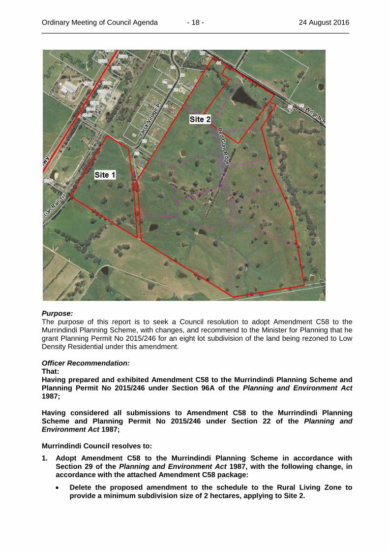
Ordinary Meeting of Council Agenda - 18 - 24 August 2016
Purpose: The purpose of this report is to seek a Council resolution to adopt Amendment C58 to the Murrindindi Planning Scheme, with changes, and recommend to the Minister for Planning that he grant Planning Permit No 2015/246 for an eight lot subdivision of the land being rezoned to Low Density Residential under this amendment. Officer Recommendation: That: Having prepared and exhibited Amendment C58 to the Murrindindi Planning Scheme and Planning Permit No 2015/246 under Section 96A of the Planning and Environment Act 1987; Having considered all submissions to Amendment C58 to the Murrindindi Planning Scheme and Planning Permit No 2015/246 under Section 22 of the Planning and Environment Act 1987; Murrindindi Council resolves to:
1. Adopt Amendment C58 to the Murrindindi Planning Scheme in accordance with Section 29 of the Planning and Environment Act 1987, with the following change, in accordance with the attached Amendment C58 package:
Delete the proposed amendment to the schedule to the Rural Living Zone to provide a minimum subdivision size of 2 hectares, applying to Site 2.
Ordinary Meeting of Council Agenda - 19 - 24 August 2016
2. Recommend to the Minister for Planning that Planning Permit No 2015/246 be granted in accordance with Section 96G of the Planning and Environment Act 1987 with the following changes, in accordance with the attached proposed Planning Permit No 2015/246:
Add the following conditions:
o Prior to the issue of a Statement of Compliance the unnamed track locally known as "Linton Lane" to the north-west of the subject land must be closed to vehicle traffic between the intersection with Maroondah Highway to the west and the existing water tanks to the east. A constructed access is required to the water tanks from Yarck Village Place only. The road closure must be to the satisfaction of the Responsible Authority and VicRoads.
o Prior to the commencement of any works in relation to the closure of the road in Condition (11), the following must occur:
a. Plans must be submitted for approval showing the proposed works to be installed on Maroondah Highway and the continuation of access from Yarck Village Place. Once approved by the relevant authority the works shall be constructed in accordance with plans. Works include rearrangement of the existing cul-de-sac, pavement and drainage works and the provision of a turning area and traffic barriers and signage.
b. An Application for Consent to Work in a Road Reserve must be submitted and approved by VicRoads for any works within the Maroondah Highway road reserve.
c. An Application for “Non Utility Minor Works within Municipal Road Reserves” must be submitted and approved by the Coordinating road authority for any works within any other road reserve.
d. Written approval must be granted by the registered land owner for any works within land that is not a government road.
o Amend the VicRoads condition to read:
Prior to the release of a Statement of Compliance for this subdivision an AUR right turn treatment at the Maroondah Highway/Wrights Road intersection must be completed at no cost to and to the satisfaction of the Roads Corporation.
3. Submit Amendment C58 to the Murrindindi Planning Scheme and Planning Permit No 2015/246, together with the prescribed information, to the Minister for Planning in accordance with Section 31 of the Planning and Environment Act 1987.
Background: At its January 2016 Ordinary Meeting, Council resolved that Council:
1. Request under Section 8A (2) and (3) of the Planning and Environment Act 1987 that the Minister for Planning authorise Murrindindi Shire Council to prepare Amendment C58 to the Murrindindi Planning Scheme as a combined permit and amendment under Section 96A of the Planning and Environment Act 1987.
2. Notify the Minister for Planning that when it exhibits Amendment C58 and proposed planning permit, Murrindindi Shire Council intends to give full notification of the amendment under Section 96C of the Planning and Environment Act 1987 for a minimum statutory exhibition period of one month.
3. When authorised by the Minister for Planning, exhibit Amendment C58 and proposed planning permit to the Murrindindi Planning Scheme under Section 96C of the Planning and Environment Act 1987.
Ordinary Meeting of Council Agenda - 20 - 24 August 2016
4. Instruct Council officers to investigate the use and future management of the land shown on site as Linton Lane.
Proposed Amendment C58 to the Murrindindi Planning Scheme affects land located to the southwest of Yarck (sites 1 and 2 indicated on the locality plan), with access via the existing road network from Wrights Road and Yarck Village Place. The existing development at Yarck Village Place consists of 16 lots varying in size from 5,000 square metres to 1.2 hectares. These lots were created in 2004, with all of them having dwellings, the last house being constructed in 2015. The exhibited Amendment C58 proposed to:
Site 1: Rezone land from Rural Living to Low Density Residential. This land is located at the south western end of Yarck Village Place and will require an extension of the Yarck Village Place as part of any approved subdivision.
Site 1: Amend the schedule to the Low Density Residential Zone to provide a minimum subdivision size of 1 hectare (only) on land proposed to be rezoned to Low Density Residential.
Site 2: Amend the schedule to the Rural Living Zone to provide a minimum subdivision size of 2 hectares, reducing the current Rural Living Zone sizes of 4 hectares minimum and 6 hectares average.
Concurrently with Amendment C58, Planning Permit No 2015/246 is proposed for an eight lot subdivision of land proposed to be rezoned to Low Density Residential under Amendment C58. Planning Permit No 2015/246 has been drafted with appropriate conditions after consultation with the relevant authorities. The proposed permit was supported by a land capability assessment, traffic impact assessment report and a native vegetation assessment. Section 96A of the Planning and Environment Act 1987 provides an opportunity for a combined application to be made for both a planning scheme amendment and a planning permit. The intent of this combined permit/amendment process is to provide an integrated approach to both amending the scheme and approving a specific proposal, providing only one exhibition process and review opportunity. The combined procedure follows the planning scheme amendment process, not the application for planning permit process. The proposal is therefore exhibited as an amendment, with the review process for hearing unresolved submissions being a planning panel, not VCAT. Council Plan/Strategies: The proposed amendment is consistent with the Our Environment goal in the Murrindindi Shire Council Plan 2013-2017 Third Year Review, specifically in relation to the strategic objectives and directions relating to Planning for Urban Growth and implementing ongoing changes to the Murrindindi Planning Scheme. The proposed amendment will also support the local community by facilitating further development options. Legal/Policy Issues: There are no legal or policy issues associated with the proposal. Amendment C58 does not propose any changes to the Local Planning Policy Framework. Amendment C58 complies with the Local Planning Policy Framework, in particular implementing the Clause 21.04 (Housing), Clause 21.04-1 (General housing in the municipality) strategy:
Ordinary Meeting of Council Agenda - 21 - 24 August 2016
Provide land and housing choice and diversity around established townships through the provision of areas zoned Low Density Residential and Rural Living in proximity to established townships and settlements. Financial/Resources/Risk: The proponent has paid prescribed fees for the combined permit/amendment to date and agreed to pay all subsequent fees and any panel hearing costs, should a panel be required to hear unresolved submissions. Consultation: Proposed Amendment C58 and Planning Permit No 2015/246 were exhibited between 14 April and 16 May 2016, with notice given to directly affected and adjoining landowners, relevant departments and authorities and prescribed Ministers. Nine (9) submissions were received and resolved, as follows:
VicRoads - proposed right hand turn at the Maroondah Highway/Wrights Road intersection will ensure that safety is maintained; mitigating works will still be required at this intersection even with the revised proposal to remove the proposed reduction in minimum subdivision size to 2 hectares in the Rural Living Zone; support the proposed closure of Linton Lane.
Support amendment and proposed permit, with a planning condition required to implement a right hand turn land at the Maroondah Highway / Wrights Road intersection.
Department of Economic Development, Jobs, Transport and Resources - no issue.
Department of Environment, Land, Water and Planning - no objections.
Goulburn Broken Catchment Management Authority - agree with proposed Goulburn Murray Water condition. No objection subject to three conditions being included in planning permit.
Country Fire Authority - initial pre permit/amendment comments given, with suggestion for conditions to be included in permit for water supply and roads. Formal submission raised no objection to the proposed closure of Linton Lane provided access to existing water tanks was maintained, with five design suggestions being provided for this access and roads generally.
Three private submissions - concerns with the use of Linton Lane as an access track, creating a dangerous situation at the intersection with the Maroondah Highway and creating dust, with suggestion to close land or convert it to a formal road.
All three submitters advised that they were satisfied following Council’s proposal to close Linton Lane being included as a condition of the proposed planning permit.
Private submission - concern with proposed reduction of minimum subdivision size in the Rural Living Zone (for Site 2) down to 2 hectares, noting that existing sizes provide a buffer between farming and residential uses and maintain right-to-farm.
The submitter advised that they were satisfied following Council’s proposal to remove the proposed reduction in minimum subdivision size in the Rural Living Zone from the amendment.
Discussion: Officers have responded to submissions by:
Proposing a planning condition to close Linton Lane, with access from Yarck Village Place only to existing water tanks. This proposed change meets concerns by three private submitters and VicRoads and has been agreed to by all three submitters and VicRoads.
Ordinary Meeting of Council Agenda - 22 - 24 August 2016
Removal of the proposed reduction in minimum subdivision size in the Rural Living Zone for Site 2 to two (2) hectares from Amendment C58. This proposed change to the amendment addresses concerns raised by the single private submitter, with this submitter agreeing to the change and now agreeing to the revised proposed amendment.
The proponents agreed with and requested these changes be made to resolve submissions to the proposed permit and amendment. As a result of these proposed changes to the permit and amendment, all submissions are now met, allowing Council to adopt the amendment without referring any unresolved submission to an independent panel for consideration. Conclusion: The proposed amendment and planning permit will facilitate further residential development in close proximity to the township of Yarck, providing a variety of lot sizes and residential zoning with easy access to an established community. Submissions have been addressed and met through the proposed closure of Linton Lane and the removal of the proposal to reduce minimum lot size for Site 2 in the existing Rural Living Zone.
6.4 END OF YEAR REPORT – CAPITAL WORKS PROGRAM 2015/2016
REF: 16/37244 Purpose: The purpose of this report is to provide Council with the final update on the 2015/2016 Capital Works Program (CWP). The report will advise Council of the final end of year financial status compared to budget allocations. Officer Recommendation: That Council:
1. Note the End of the Year Report– Capital Works Program 2015/2016.
2. Endorse the reallocation of savings and unspent funds as recommended in Table 1 within this report.
3. Note that projects in Table 2 that were not completed are now complete or being completed.
4. Note that savings and unspent funds to the value of $582,419 from the Capital Works Program be returned to the Reserves in accordance with the Council’s Capital Works Expenditure Policy.
5. Endorse that $170,017 from those savings (sealed roads) returned to Reserves be approved for use in the 2016-2017 roads program if required to meet the ongoing “own effort” requirements of the Roads To Recovery (R2R) funding.
Background: At the Ordinary Council Meeting on 23 July 2012 Council resolved that a quarterly report on the progress and financial status of the Capital Works Program (CWP) be incorporated in Council’s regular reporting cycle. This report presents the end of year report of the 2015/2016 CWP The 2015/2016 CWP comprises those projects endorsed by Council as part of the 2015/2016 capital works budget as well as those projects identified for carry forward from the 2014/2015 program.
Ordinary Meeting of Council Agenda - 23 - 24 August 2016
Council Plan/Strategies: Council Plan 2013-2017:
Our Economy – Strategic objective “We will advocate for the provision of infrastructure and services that support business growth”
Our Environment – Strategic objective “We will use resources more efficiently and effectively”
Our Environment – Strategic objective “We will apply a whole of life approach to the management and maintenance of Council’s assets”
Legal/Policy Issues: Council is obliged to prepare a budget annually. The preparation of a detailed Capital Works Program informs and significantly impacts on the budget. Council’s Capital Works Expenditure Policy sets out Council’s commitment to manage and care for its assets into the future which meet the needs of the community. It highlights the importance of building the Infrastructure Reserve as a source of funding for future capital works expenditure. The policy identifies a process for the transfer of project savings from the capital works program to the Infrastructure Reserve to assist in funding future capital renewal requirements. Financial/Resources/Risk: There is a risk that Council may not invest enough in the replacement of infrastructure to maintain services reasonably required by the community. The preparation of a Ten Year Capital Improvement Plan seeks to mitigate this risk by informing Council of the financial impacts of investment in capital replacement. The consequence of an insufficient capital investment in replacement is a widening infrastructure gap. The adoption of a Ten Year Capital Improvement Plan provides Council with the ability to manage the infrastructure renewal gap by identifying the level of investment and/or the level of asset rationalisation required Timely reporting of financial issues assists in early identification of the need to reallocate costs where required. Reporting of project progress also provides Council and the community with an understanding of when projects will commence and will communicate any delays if they occur. Consultation: The June end of year Capital Works report has been developed with the respective officers responsible for finance, asset management and the delivery of the capital works program. Discussion: The end of financial year CWP report provides commentary on the following features of the program:
1. Details of the projects that were delayed or other developments that have arisen significantly affecting the budget for the project or program delivery.
2. List of projects to be carried forward to 2016/2017 including recommendations for proposed reallocation of funds in accordance with the Capital Works Expenditure Policy.
The adopted budget for the 2015/2016 CWP was $7.516 million. Carry forwards and additional grant funded projects resulted in a revised CWP of $12.107 million. $4.383 million is recommended for carry forward as detailed in this report. The infrastructure component of the CWP was $6.101 million.
Ordinary Meeting of Council Agenda - 24 - 24 August 2016
The following projects to the value of $494,633 were unavoidably postponed and are to be delivered within next year’s program:
Connecting and Revitalising Eildon Retail Precinct
Timber Tramway Museum - Renewal
Leckie Park Pavilion
Bus Shelter Construction
Flood Levee Buxton
Snodgrass Street Yea - Special Charge Scheme When considering these postponed projects, 87% of the remaining infrastructure projects from the adopted budget were delivered. The most significant project not delivered within the financial year was the design and construction of a new leachate pond at the landfill. Unavoidable delays were encountered with prolonged EPA audit requirements, latent site conditions and inclement weather. In delivering the year’s infrastructure capital works, a significant cost saving of $1,455,150 was achieved. Further, officers identified additional bridge renewal projects which could be brought forward from future years programs. These bridge renewal works were prioritised in a recent condition audit and were brought into the program from mid year as the savings were realised. These additional works accounted for $872,731 of the savings with the balance of $582,419 to be returned to the infrastructure reserve as detailed in Table 3. This additional expenditure allowed Council to meet its immediate “own effort” requirements of the R2R grant funding and reduce the infrastructure renewal gap. It is proposed that $170,017 from those savings (sealed roads) to be returned to the infrastructure reserve be approved for use in the 2016-2017 roads program if required to meet the ongoing “own effort” requirements of the R2R funding. A number of infrastructure projects were added to the CWP throughout the year following receipt of grant funding. The additional projects included:
Library Generator Program
Public Convenience Upgrade in Yea
Eildon-Alexandra Trail Cultural Heritage Plan
Design of the Alexandra to Eildon Rail Trail
Connecting and Revitalising Eildon Retail Precinct– Stage 2
Alexandra Township Rail Trail Link
Yea Regional Saleyards Stage 2
Ghin Ghin Road Black Spot
Additional R2R funding These additional infrastructure projects and carry forwards from the previous year resulted in an annual revised infrastructure budget of $10.064 million. The total value of infrastructure work delivered or committed for the year was $8.279 million with savings of $1.456 million. The following outlines issues which significantly affected program delivery and identifies those projects which will need to carry forward into next year’s program.
Ordinary Meeting of Council Agenda - 25 - 24 August 2016
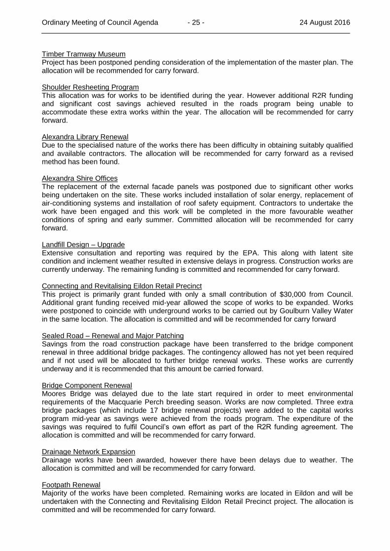
Timber Tramway Museum Project has been postponed pending consideration of the implementation of the master plan. The allocation will be recommended for carry forward. Shoulder Resheeting Program This allocation was for works to be identified during the year. However additional R2R funding and significant cost savings achieved resulted in the roads program being unable to accommodate these extra works within the year. The allocation will be recommended for carry forward. Alexandra Library Renewal Due to the specialised nature of the works there has been difficulty in obtaining suitably qualified and available contractors. The allocation will be recommended for carry forward as a revised method has been found. Alexandra Shire Offices The replacement of the external facade panels was postponed due to significant other works being undertaken on the site. These works included installation of solar energy, replacement of air-conditioning systems and installation of roof safety equipment. Contractors to undertake the work have been engaged and this work will be completed in the more favourable weather conditions of spring and early summer. Committed allocation will be recommended for carry forward. Landfill Design – Upgrade Extensive consultation and reporting was required by the EPA. This along with latent site condition and inclement weather resulted in extensive delays in progress. Construction works are currently underway. The remaining funding is committed and recommended for carry forward. Connecting and Revitalising Eildon Retail Precinct This project is primarily grant funded with only a small contribution of $30,000 from Council. Additional grant funding received mid-year allowed the scope of works to be expanded. Works were postponed to coincide with underground works to be carried out by Goulburn Valley Water in the same location. The allocation is committed and will be recommended for carry forward Sealed Road – Renewal and Major Patching Savings from the road construction package have been transferred to the bridge component renewal in three additional bridge packages. The contingency allowed has not yet been required and if not used will be allocated to further bridge renewal works. These works are currently underway and it is recommended that this amount be carried forward.
Bridge Component Renewal Moores Bridge was delayed due to the late start required in order to meet environmental requirements of the Macquarie Perch breeding season. Works are now completed. Three extra bridge packages (which include 17 bridge renewal projects) were added to the capital works program mid-year as savings were achieved from the roads program. The expenditure of the savings was required to fulfil Council’s own effort as part of the R2R funding agreement. The allocation is committed and will be recommended for carry forward. Drainage Network Expansion Drainage works have been awarded, however there have been delays due to weather. The allocation is committed and will be recommended for carry forward. Footpath Renewal Majority of the works have been completed. Remaining works are located in Eildon and will be undertaken with the Connecting and Revitalising Eildon Retail Precinct project. The allocation is committed and will be recommended for carry forward.
Ordinary Meeting of Council Agenda - 26 - 24 August 2016
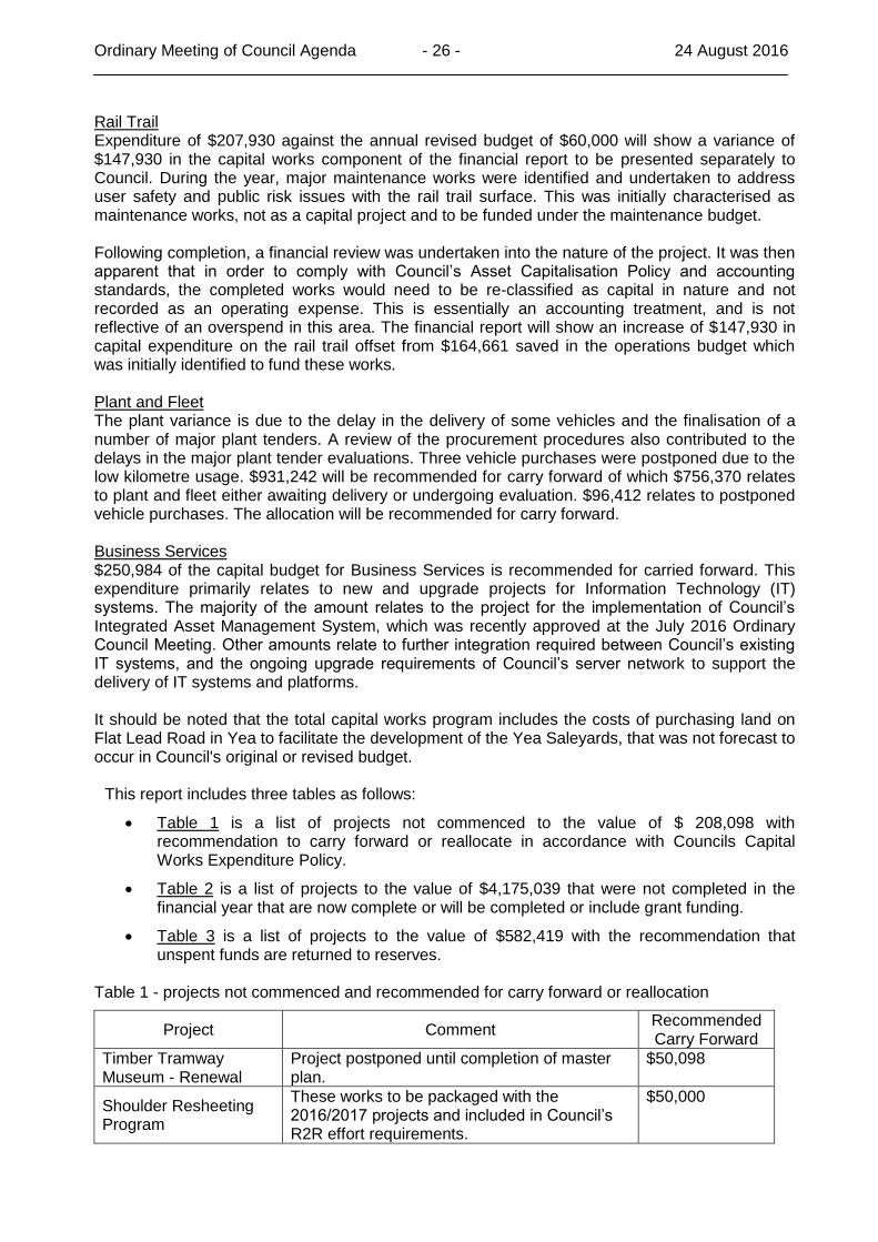
Rail Trail Expenditure of $207,930 against the annual revised budget of $60,000 will show a variance of $147,930 in the capital works component of the financial report to be presented separately to Council. During the year, major maintenance works were identified and undertaken to address user safety and public risk issues with the rail trail surface. This was initially characterised as maintenance works, not as a capital project and to be funded under the maintenance budget. Following completion, a financial review was undertaken into the nature of the project. It was then apparent that in order to comply with Council’s Asset Capitalisation Policy and accounting standards, the completed works would need to be re-classified as capital in nature and not recorded as an operating expense. This is essentially an accounting treatment, and is not reflective of an overspend in this area. The financial report will show an increase of $147,930 in capital expenditure on the rail trail offset from $164,661 saved in the operations budget which was initially identified to fund these works. Plant and Fleet The plant variance is due to the delay in the delivery of some vehicles and the finalisation of a number of major plant tenders. A review of the procurement procedures also contributed to the delays in the major plant tender evaluations. Three vehicle purchases were postponed due to the low kilometre usage. $931,242 will be recommended for carry forward of which $756,370 relates to plant and fleet either awaiting delivery or undergoing evaluation. $96,412 relates to postponed vehicle purchases. The allocation will be recommended for carry forward. Business Services $250,984 of the capital budget for Business Services is recommended for carried forward. This expenditure primarily relates to new and upgrade projects for Information Technology (IT) systems. The majority of the amount relates to the project for the implementation of Council’s Integrated Asset Management System, which was recently approved at the July 2016 Ordinary Council Meeting. Other amounts relate to further integration required between Council’s existing IT systems, and the ongoing upgrade requirements of Council’s server network to support the delivery of IT systems and platforms. It should be noted that the total capital works program includes the costs of purchasing land on Flat Lead Road in Yea to facilitate the development of the Yea Saleyards, that was not forecast to occur in Council's original or revised budget.
This report includes three tables as follows:
Table 1 is a list of projects not commenced to the value of $ 208,098 with recommendation to carry forward or reallocate in accordance with Councils Capital Works Expenditure Policy.
Table 2 is a list of projects to the value of $4,175,039 that were not completed in the financial year that are now complete or will be completed or include grant funding.
Table 3 is a list of projects to the value of $582,419 with the recommendation that unspent funds are returned to reserves.
Table 1 - projects not commenced and recommended for carry forward or reallocation
Project Comment Recommended Carry Forward
Timber Tramway Museum - Renewal
Project postponed until completion of master plan.
$50,098
Shoulder Resheeting Program
These works to be packaged with the 2016/2017 projects and included in Council’s R2R effort requirements.
$50,000
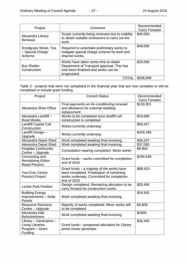
Ordinary Meeting of Council Agenda - 27 - 24 August 2016
Project Comment Recommended Carry Forward
Alexandra Library Renewal
Scope currently being reviewed due to inability to obtain suitable contractors to carry out the work.
$40,000.
Snodgrass Street, Yea – Special Charge Scheme
Required to undertake preliminary works to instigate special charge scheme for kerb and channel works.
$48,000
Bus Shelter Construction
Works have taken some time to obtain Department of Transport approval. This has now been finalised and works can be progressed.
$20,000
TOTAL $208,098
Table 2 - projects that were not completed in the financial year that are now complete or will be completed or include grant funding
Project Current Status Recommended Carry Forward
Alexandra Shire Office Final payments on Air-conditioning renewal and allowance for external cladding replacement
$133,301
Alexandra Landfill – Road Works
Works to be completed once landfill cell construction is completed
$19,689
Landfill Capital Cell Construction
Works currently underway $59,427
Landfill Design – Upgrade
Works currently underway $429,186
Alexandra Depot Shed Work completed awaiting final invoicing. $36,237
Alexandra Depot Shed Work completed awaiting final invoicing $37,000
Kinglake Community Centre – Upgrade
Consultation nearing completion. Minor works $9,900
Connecting and Revitalising Eildon Retail Precinct
Grant funds – works committed for completion end of 2016
$295,549
Yea Civic Centre Precinct Project
Grant funds – a majority of the works have been completed. Finalisation of remaining works underway. Committed for completion end of 2016
$88,423
Leckie Park Pavilion Design completed. Remaining allocation to be carry forward for construction works.
$20,455
Building Energy Improvements – Solar Panels
Work completed awaiting final invoicing $24,500
Resource Recovery Centre – Upgrade
Majority of works completed. Minor works still to be completed
$4,909
Alexandra Hall Refurbishment
Work completed awaiting final invoicing $2905
Library – Generators – Living Libraries Program – Grant Funding
Grant funds – postponed allocation for Library prime mover generator.
$36,345
Ordinary Meeting of Council Agenda - 28 - 24 August 2016
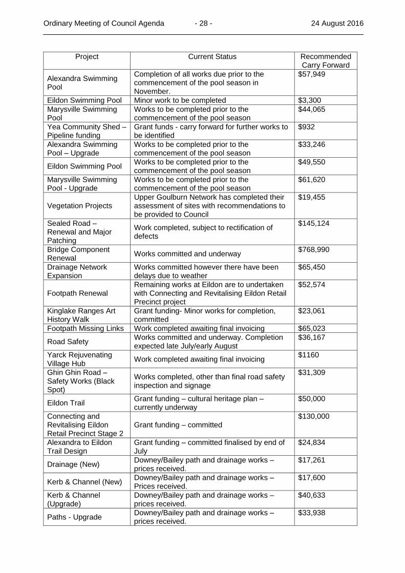
Project Current Status Recommended Carry Forward
Alexandra Swimming Pool
Completion of all works due prior to the commencement of the pool season in November.
$57,949
Eildon Swimming Pool Minor work to be completed $3,300
Marysville Swimming Pool
Works to be completed prior to the commencement of the pool season
$44,065
Yea Community Shed – Pipeline funding
Grant funds - carry forward for further works to be identified
$932
Alexandra Swimming Pool – Upgrade
Works to be completed prior to the commencement of the pool season
$33,246
Eildon Swimming Pool Works to be completed prior to the commencement of the pool season
$49,550
Marysville Swimming Pool - Upgrade
Works to be completed prior to the commencement of the pool season
$61,620
Vegetation Projects Upper Goulburn Network has completed their assessment of sites with recommendations to be provided to Council
$19,455
Sealed Road – Renewal and Major Patching
Work completed, subject to rectification of defects
$145,124
Bridge Component Renewal
Works committed and underway $768,990
Drainage Network Expansion
Works committed however there have been delays due to weather
$65,450
Footpath Renewal Remaining works at Eildon are to undertaken with Connecting and Revitalising Eildon Retail Precinct project
$52,574
Kinglake Ranges Art History Walk
Grant funding- Minor works for completion, committed
$23,061
Footpath Missing Links Work completed awaiting final invoicing $65,023
Road Safety Works committed and underway. Completion expected late July/early August
$36,167
Yarck Rejuvenating Village Hub
Work completed awaiting final invoicing $1160
Ghin Ghin Road – Safety Works (Black Spot)
Works completed, other than final road safety inspection and signage
$31,309
Eildon Trail Grant funding – cultural heritage plan – currently underway
$50,000
Connecting and Revitalising Eildon Retail Precinct Stage 2
Grant funding – committed $130,000
Alexandra to Eildon Trail Design
Grant funding – committed finalised by end of July
$24,834
Drainage (New) Downey/Bailey path and drainage works – prices received.
$17,261
Kerb & Channel (New) Downey/Bailey path and drainage works – Prices received.
$17,600
Kerb & Channel (Upgrade)
Downey/Bailey path and drainage works – prices received.
$40,633
Paths - Upgrade Downey/Bailey path and drainage works – prices received.
$33,938
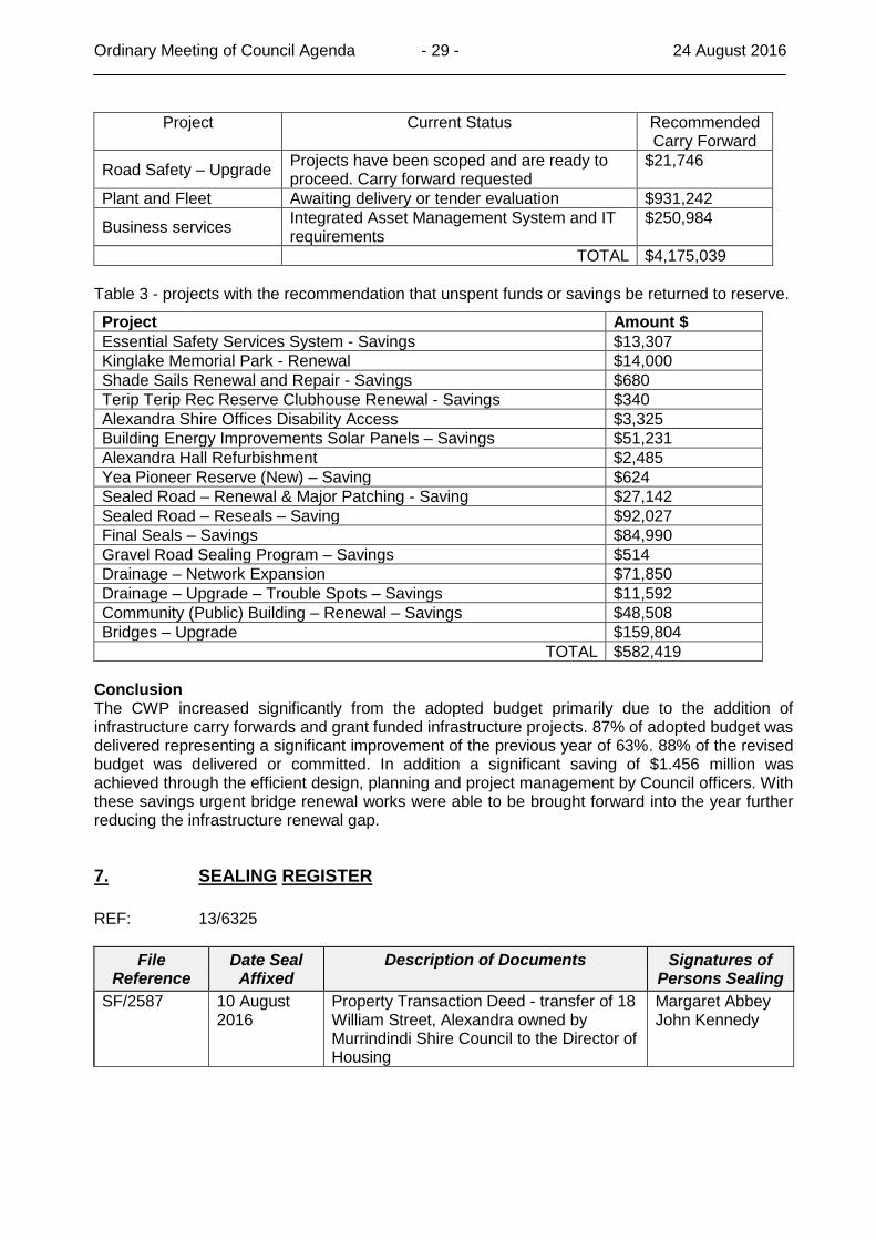
Ordinary Meeting of Council Agenda - 29 - 24 August 2016
Project Current Status Recommended Carry Forward
Road Safety – Upgrade Projects have been scoped and are ready to proceed. Carry forward requested
$21,746
Plant and Fleet Awaiting delivery or tender evaluation $931,242
Business services Integrated Asset Management System and IT requirements
$250,984
TOTAL $4,175,039
Table 3 - projects with the recommendation that unspent funds or savings be returned to reserve.
Project Amount $
Essential Safety Services System - Savings $13,307
Kinglake Memorial Park - Renewal $14,000
Shade Sails Renewal and Repair - Savings $680
Terip Terip Rec Reserve Clubhouse Renewal - Savings $340
Alexandra Shire Offices Disability Access $3,325
Building Energy Improvements Solar Panels – Savings $51,231
Alexandra Hall Refurbishment $2,485
Yea Pioneer Reserve (New) – Saving $624
Sealed Road – Renewal & Major Patching - Saving $27,142
Sealed Road – Reseals – Saving $92,027
Final Seals – Savings $84,990
Gravel Road Sealing Program – Savings $514
Drainage – Network Expansion $71,850
Drainage – Upgrade – Trouble Spots – Savings $11,592
Community (Public) Building – Renewal – Savings $48,508
Bridges – Upgrade $159,804
TOTAL $582,419
Conclusion The CWP increased significantly from the adopted budget primarily due to the addition of infrastructure carry forwards and grant funded infrastructure projects. 87% of adopted budget was delivered representing a significant improvement of the previous year of 63%. 88% of the revised budget was delivered or committed. In addition a significant saving of $1.456 million was achieved through the efficient design, planning and project management by Council officers. With these savings urgent bridge renewal works were able to be brought forward into the year further reducing the infrastructure renewal gap.
7. SEALING REGISTER
REF: 13/6325
File Reference
Date Seal Affixed
Description of Documents Signatures of Persons Sealing
SF/2587 10 August 2016
Property Transaction Deed - transfer of 18 William Street, Alexandra owned by Murrindindi Shire Council to the Director of Housing
Margaret Abbey John Kennedy
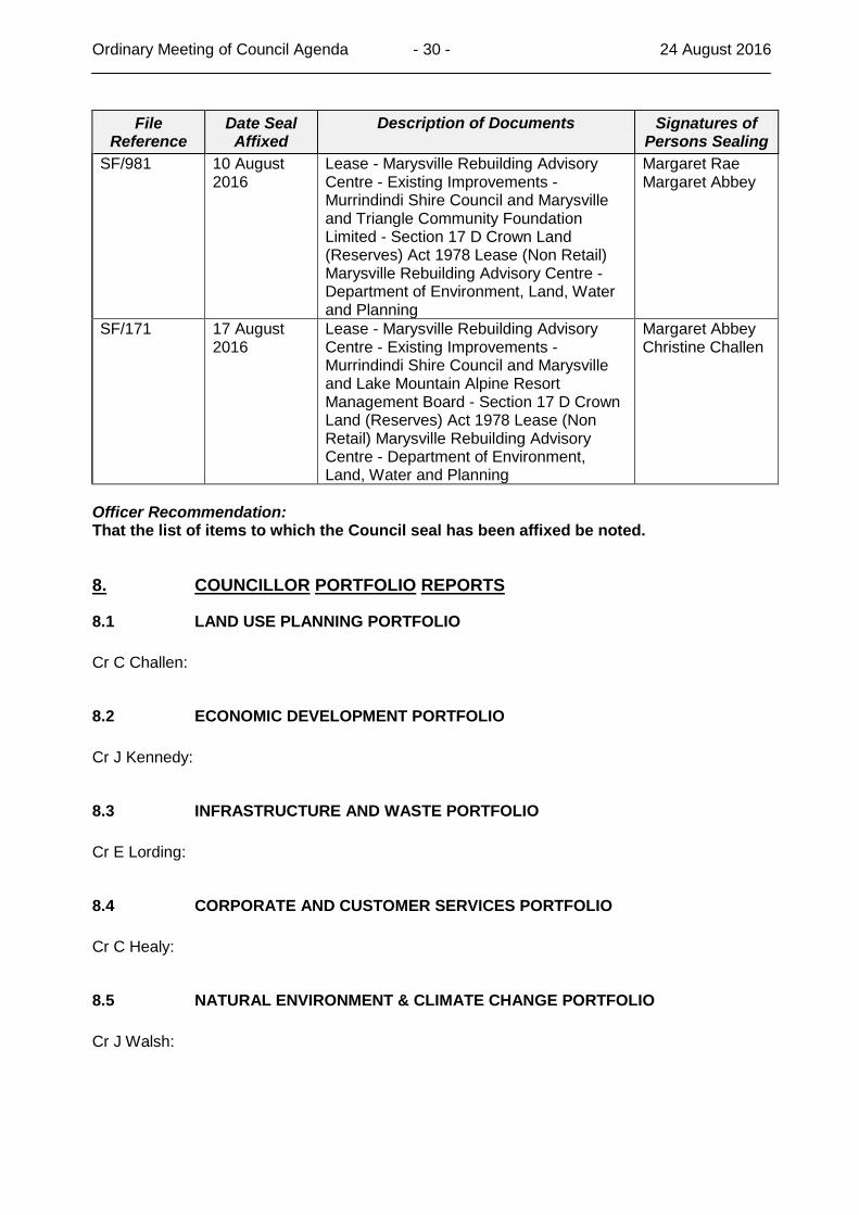
Ordinary Meeting of Council Agenda - 30 - 24 August 2016
File Reference
Date Seal Affixed
Description of Documents Signatures of Persons Sealing
SF/981 10 August 2016
Lease - Marysville Rebuilding Advisory Centre - Existing Improvements - Murrindindi Shire Council and Marysville and Triangle Community Foundation Limited - Section 17 D Crown Land (Reserves) Act 1978 Lease (Non Retail) Marysville Rebuilding Advisory Centre - Department of Environment, Land, Water and Planning
Margaret Rae Margaret Abbey
SF/171 17 August 2016
Lease - Marysville Rebuilding Advisory Centre - Existing Improvements - Murrindindi Shire Council and Marysville and Lake Mountain Alpine Resort Management Board - Section 17 D Crown Land (Reserves) Act 1978 Lease (Non Retail) Marysville Rebuilding Advisory Centre - Department of Environment, Land, Water and Planning
Margaret Abbey Christine Challen
Officer Recommendation: That the list of items to which the Council seal has been affixed be noted.
8. COUNCILLOR PORTFOLIO REPORTS
8.1 LAND USE PLANNING PORTFOLIO
Cr C Challen:
8.2 ECONOMIC DEVELOPMENT PORTFOLIO
Cr J Kennedy:
8.3 INFRASTRUCTURE AND WASTE PORTFOLIO
Cr E Lording:
8.4 CORPORATE AND CUSTOMER SERVICES PORTFOLIO
Cr C Healy:
8.5 NATURAL ENVIRONMENT & CLIMATE CHANGE PORTFOLIO
Cr J Walsh:
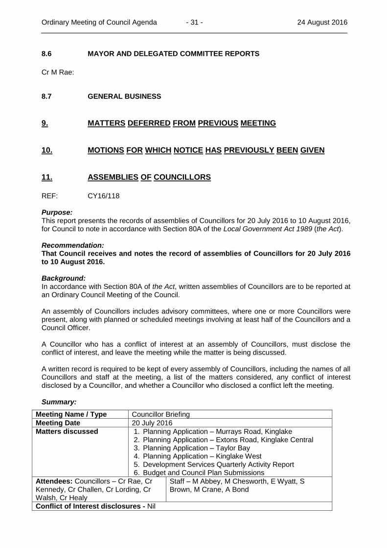
Ordinary Meeting of Council Agenda - 31 - 24 August 2016
8.6 MAYOR AND DELEGATED COMMITTEE REPORTS
Cr M Rae:
8.7 GENERAL BUSINESS
9. MATTERS DEFERRED FROM PREVIOUS MEETING
10. MOTIONS FOR WHICH NOTICE HAS PREVIOUSLY BEEN GIVEN
11. ASSEMBLIES OF COUNCILLORS
REF: CY16/118 Purpose: This report presents the records of assemblies of Councillors for 20 July 2016 to 10 August 2016, for Council to note in accordance with Section 80A of the Local Government Act 1989 (the Act). Recommendation: That Council receives and notes the record of assemblies of Councillors for 20 July 2016 to 10 August 2016. Background: In accordance with Section 80A of the Act, written assemblies of Councillors are to be reported at an Ordinary Council Meeting of the Council. An assembly of Councillors includes advisory committees, where one or more Councillors were present, along with planned or scheduled meetings involving at least half of the Councillors and a Council Officer. A Councillor who has a conflict of interest at an assembly of Councillors, must disclose the conflict of interest, and leave the meeting while the matter is being discussed. A written record is required to be kept of every assembly of Councillors, including the names of all Councillors and staff at the meeting, a list of the matters considered, any conflict of interest disclosed by a Councillor, and whether a Councillor who disclosed a conflict left the meeting. Summary:
Meeting Name / Type Councillor Briefing
Meeting Date 20 July 2016
Matters discussed 1. Planning Application – Murrays Road, Kinglake 2. Planning Application – Extons Road, Kinglake Central 3. Planning Application – Taylor Bay 4. Planning Application – Kinglake West 5. Development Services Quarterly Activity Report 6. Budget and Council Plan Submissions
Attendees: Councillors – Cr Rae, Cr Kennedy, Cr Challen, Cr Lording, Cr Walsh, Cr Healy
Staff – M Abbey, M Chesworth, E Wyatt, S Brown, M Crane, A Bond
Conflict of Interest disclosures - Nil
Ordinary Meeting of Council Agenda - 32 - 24 August 2016
Meeting Name / Type Council Pre-Meeting
Meeting Date 27 July 2016
Matters discussed 1. Draft Budget Submissions 2. Planning Application - Kinglake 3. Planning Application – Taylor Bay 4. Webster St, Alexandra 5. Connecting and Revitalising Eildon Town Square 6. Asset Management Systems and Support Services 7. Leachate Pond Supervision and Construction
Attendees: Councillors – Cr Rae, Cr Kennedy, Cr Challen, Cr Lording, Cr Healy, Cr Walsh
Staff – M Abbey, E Wyatt, J Canny, S Brown, M Crane, A Bond, N McNamara, M Leitinger
Conflict of Interest disclosures - Nil
Meeting Name / Type Councillor Briefing
Meeting Date 3 August 2016
Matters discussed 1. Staffing Levels 2. Review of Local Government Act 3. Draft Council Budget
Attendees: Councillors – Cr Rae, Cr Kennedy, Cr Lording, Cr Healy, Cr Walsh and Cr Challen.
Staff – M Abbey, M Chesworth, A Bond, S Brown
Conflict of Interest disclosures - Nil
Meeting Name / Type Murrindindi Environment Advisory Committee Meeting
Meeting Date 9 August 2016
Matters discussed 1. Environment Strategy 2. Environment Strategy Stakeholder Engagement Plan 3. Environment Strategy Community Survey
Attendees: Councillors – Cr Challen, Cr Walsh
Staff – M Leitinger, Z Blakeney
Conflict of Interest disclosures – Cr Challen wished to indicate that the Green Army had worked on her property.
Meeting Name / Type Councillor Briefing Session
Meeting Date 10 August 2016
Matters discussed 1. Councillor Induction 2. Australia Day Activities 3. Pre 2006 Native Vegetation Offsets Program 4. Draft Environment Strategy 5. Service Agreement VicRoads
Attendees: Councillors – Cr Kennedy, Cr Challen, Cr Walsh
Staff – M Abbey, E Wyatt, M Chesworth, S Brown, H Duldig, S McNair, M Leitinger
Conflict of Interest disclosures - Nil
12. URGENT BUSINESS
13. CONFIDENTIAL ITEMS
It is proposed that the following items be considered in closed session.
Tender Cont 16/7 For The Supply & Delivery of One (1) Backhoe Loader

Ordinary Meeting of Council Agenda - 33 - 24 August 2016
The meeting is to be closed to members of the public as the discussion of this item is confidential pursuant to (Section 89(2)(h) of the Local Government Act 1989) - any other matter which the Council or special committee considers would prejudice the Council or any person.