agenda regular meeting of the board of land...
TRANSCRIPT

Updated 12/18/17
Complete agenda item information can be found on the DNRC website at http://dnrc.mt.gov/LandBoard
AGENDA REGULAR MEETING OF THE BOARD OF LAND COMMISSIONERS
December 18, 2017, at 9:00 am Supreme Court Chambers, Joseph P. Mazurek Building
215 North Sanders, 4th floor Helena, MT
ACTION ITEMS 1217-1 Montana Heritage Commission: Johnson Land Donation Benefits: N/A (non-trust land) Location: Madison County APPROVED 5-0 1217-2 Timber Sales A. Henderson Hill Benefits: Public Buildings Location: Mineral B. Lolo Peak Salvage Benefits: Common Schools Location: Missoula, Ravalli Counties C. Tornilla Creek Benefits: Common Schools Location: Sanders APPROVED 5-0 1217-3 Oil and Gas Lease Sale (December 5, 2017) Benefits: Common Schools, MSU Morrill Trust, Public Land Trust-Navigable Rivers Location: Big Horn, Garfield, Glacier, Powder River, Richland, Roosevelt, Sweet Grass, Toole
Counties APPROVED 5-0 1217-4 Informational Item: Biennial Cabin Site Lease Rate Review
(September 2015 – September 2017) Benefits: Common Schools, School for Deaf & Blink, Montana State University, Montana Tech, Pine Hills, Public Buildings, University of Montana, Veterans Home, Eastern College– MSU/Western College–UM Location: Beaverhead, Big Horn, Blaine, Broadwater, Cascade, Chouteau, Custer, Daniels, Fallon, Fergus, Flathead, Gallatin, Golden Valley, Hill, Judith Basin, Lake, Lewis & Clark, Lincoln, Madison, McCone, Meagher, Mineral, Missoula, Musselshell, Phillips, Pondera, Powder River, Powell, Prairie, Richland, Rosebud, Sanders, Sheridan, Stillwater, Sweet Grass, Toole, Valley, Wheatland, Wibaux, Yellowstone Counties 1217-5 Easements Benefits: Common Schools, Montana Tech, Public Buildings, Public Land Trust, Veterans Home Location: Cascade, Chouteau, Dawson, Flathead, Lewis & Clark, Liberty, Missoula, Park, Toole, Yellowstone Counties APPROVED 5-0 1217-6 Informational Item: Forest Insect and Disease Update Benefits: N/A Location: statewide PUBLIC COMMENT


1217-1 MONTANA HERITAGE COMMISSION:
JOHNSON LAND DONATION


Land Board Agenda Item December 18, 2017
1217-1 Montana Heritage Commission: Johnson Land Donation Location: Madison County Trust Benefits: N/A (non-trust) Trust Revenue: N/A Item Summary Ms. Evalyn Batten Johnson is the current owner of a 6.708 acre parcel of land identified as Certificate of Survey No. 7/1594, Portion of Batten Placer 1232 within Sections 21 and 22 in Township 6 South, Range 3 West, Madison County. Ms. Johnson has offered to donate this parcel to the Montana Heritage Preservation & Development Commission (the Commission) with the caveat that the property be restricted to use by the Commission. The parcel does not have any owner improvements located upon it; however a portion of the property is occupied by train tracks operated by the state-owned Alder Gulch Short Line Railroad. Operation of the railroad is limited to tourist traffic from Memorial Day through Labor Day, and the short line railroad transports riders beween Virginia City and Nevada City. Currently there is not a legally binding agreement or easement in place that would allow the railroad tracks to remain in place should Ms. Johnson sell the property or otherwise dispose of it. The Commission owns the adjacent parcels to Ms. Johnson, and the donation would block up the Commission’s ownership and solidify the ability to continue operation of the short line railroad. Appraisal, Hazardous Materials, Public Notice The parcel was initially appraised in October 2016 by a certified general appraiser, with an updated appraisal completed November 2017. The conclusion of value of the parcel is $92,000. As the proposal is to donate the parcel, no monetary compensation would be paid to Ms. Johnson. A Phase I environmental study was completed on the property in November 2017. The report did not identify any issues or concerns regarding hazardous materials. Tailings piles are present on the property, however no hazardous materials were identified or found. Further, environmental databases accessed do not contain any information regarding hazardous materials being present on the parcel. It is concluded that there are no environmental concerns associated with this parcel. On June 9, 2017, the Commission held a public hearing for the donation of this parcel. Public comment was received from the land donor, the land donor’s attorney, and a local resident. All comments were positive and supportive of the land donation. The Commission approved the acquisition of the donation pending a favorable hazardous materials study. Notice has been provided in local newspapers as well as on the Commission’s website soliciting further public comment specific to the Land Board meeting and proposed action. Department Recommendation The Commission requests the Land Board approve the donation of the Johnson parcel to the Montana Heritage Preservation & Development Commission.
1217-1
Page 1 of 2 Created 12/8/17

Montana State Library, Copyright:© 2013 National Geographic Society, i-cubed, U.S. Department ofAgriculture Farm Services Agency Aerial Photography Field Office
Montana Heritage Commission Donation Parcel
O0 0.1 0.2 0.30.05Miles
Location: Madison County, MT Prepared by: RMWPrepared on: 07 DEC 2017Projection: NAD 1983 - MT State Plane
LegendDonation Parcel
Donation Parcel
Legal Description: S22, T06 S, R03 W,C.O.S. 7/1594, POR of Batten Placer 1232
MT Heritage Commission
MT Heritage Commission
MT Heritage Commission
MT Heritage Commission
MT Heritage Commission
1217-1
Page 2 of 2 Created 12/8/17
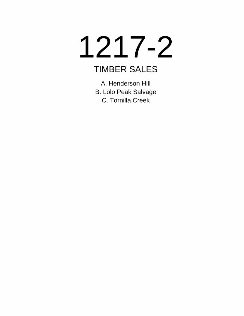
1217-2 TIMBER SALES
A. Henderson Hill B. Lolo Peak Salvage
C. Tornilla Creek


Land Board Agenda Item December 18, 2017
1217-2A Timber Sale: Henderson Hill
Location: Mineral County Sections 19 & 30, T19N, R29W
Trust Benefits: Public Buildings Trust Revenue: $264,670 (estimated, minimum bid)
Item Summary
Location: The Henderson Hill Timber Sale is located approximately 13 miles west of St. Regis, MT.
Size and Scope: This sale includes 5 harvest units (294 acres) of tractor and skyline logging.
Volume: The estimated volume is 16,890 tons (2.6 MMBF) of sawlogs.
Estimated Return: The minimum bid is $15.29 per ton, which would generate approximately $264,670 for the Public Buildings Trust and approximately $55,392 in Forest Improvement fees.
Prescription: This sale has a harvest prescription of individual tree selection. This prescription will provide variability by maintaining uneven-aged seral species and ensuring that a mix of shade-intolerant and tolerant species exists post-harvest. All units have been affected by some level of mountain pine beetle mortality, with the highest mortality being in lodgepole pine. This prescription will remove trees affected by insects, disease, and undesirable genetics. Timber harvest will remove ponderosa pine, Douglas-fir, western larch, lodgepole pine, white fir, and white pine.
Road Construction/Maintenance: The Department of Natural Resources and Conservation (DNRC) is proposing 1.62 miles of new permanent road construction and 4.3 miles of road maintenance.
Access: Access has been obtained to this timber sale via a cost share agreement with the Lolo National Forest.
Public Comments: Five comments were received. The Confederated Salish and Kootenai Tribes reminded DNRC that cultural resources important to their nation are present throughout the region and requested to be notified if any new or additional information arose during the project. If previously unknown cultural or paleontological materials are identified during project-related activities, all work would cease until a professional assessment of such resources can be made. Montana Fish, Wildlife, and Parks commented on potential effects of harvesting in big game winter/spring range. A DNRC wildlife biologist analyzed big game in the environmental assessment. Two comments were in support of the proposed project. An adjacent landowner was concerned with aesthetics since he recently built his house near the project area. The project leader took measures to space the sale unit boundary and leave a few more trees on the visible ridge to mitigate impacts to the landowner’s viewshed.
DNRC Recommendation
The director recommends the Land Board direct DNRC to sell the Henderson Hill Timber Sale.
1217-2A
Page 1 of 4 Created 12/8/17

HENDERSON HILL TIMBER SALE VICINITY MAP
Project Name: Henderson Hill Timber Sale
Project Location: Sections 19 & 30 T19N R29W
1217-2A
Page 2 of 4 Created 12/8/17

Sources: Esri, HERE, DeLorme, Intermap, increment P Corp., GEBCO, USGS, FAO, NPS, NRCAN, GeoBase, IGN, Kadaster NL, Ordnance Survey, EsriJapan, METI, Esri China (Hong Kong), swisstopo, MapmyIndia, © OpenStreetMap contributors, and the GIS User Community
Henderson Hill Timber Sale Harvest Unit Map
/
0 0.1 0.2 0.3 0.40.05Miles
Montana DNRC provides this product for informational purposes only and does not accept responsibility for errors, omissions or
posit ional accuracy. Data displayed herein is not warrantied to be suitable for legal, engineering or survey purposes. User assumes all
responsibility and discretion for use of this map.
1217-2A
Page 3 of 4 Created 12/8/17

Sources: Esri, HERE, DeLorme, Intermap, increment P Corp., GEBCO, USGS, FAO, NPS, NRCAN, GeoBase, IGN, Kadaster NL, Ordnance Survey, Esri Japan, METI, Esri China (Hong Kong),swisstopo, MapmyIndia, © OpenStreetMap contributors, and the GIS User Community
Henderson Hill Timber Sale Haul Route Map
/
0 0.9 1.8 2.7 3.60.45Miles
TextMontana DNRC pr ov ides this product for in for mational purposes on ly and does not acc ept responsib il ity for er rors,
om is sions or pos itional ac curacy. Data disp layed here in is not warrantied to be su i tab le for legal , engineering or survey purpos es . Us er ass umes a ll r es ponsibi li ty and d isc retion for use of this m ap.
USFS 1191
USFS 444
I-90
1217-2A
Page 4 of 4 Created 12/8/17

Land Board Agenda Item December 18, 2017
1217-2B Timber Sale: Lolo Peak Salvage
Location: Missoula and Ravalli County Section 16, T10N, R20W
Section 16, T11N, R20W Trust Benefits: Common Schools Trust Revenue: $36,445 (estimated, minimum bid)
Item Summary
Location: The Lolo Peak Salvage Timber Sale is located approximately 2 miles southeast of Lolo and Florence, MT.
Size and Scope: The sale includes 10 harvest units (402 acres) of tractor and skyline logging.
Volume: The estimated volume is 12,028 tons (2.2 MMBF) of sawlogs.
Estimated Return: The minimum bid is $3.03 per ton, which would generate approximately $36,445 for the Common Schools Trust and approximately $45,586 in Forest Improvement fees.
Prescription: This salvage project is the result of the 2017 Lolo Peak Fire. This sale has salvage harvest and single tree selection prescriptions. Fire killed and damaged trees will be harvested in both sections. Single tree selection will be used to harvest green timber with poor form and vigor and those infested with insects or disease. Timber harvest will remove ponderosa pine, Douglas-fir, and western larch.
Road Construction/Maintenance: The Department of Natural Resources and Conservation (DNRC) is proposing 3.5 miles of new permanent road construction, 1.4 miles of road reconstruction, 0.2 miles of road reclamation, and 7 miles of road maintenance.
Access: Access is obtained through a temporary road use permit with MetLife and the US Forest Service.
Public Comments: Twelve comments were received. One commenter was concerned about soil disturbance and weeds, wildlife security, and new roads. The spread of noxious weeds will be mitigated by equipment washing and weed spraying. The roads will be closed to motorized public access post-harvest so there would be negligible changes to wildlife security habitat. Also, there would be mitigations implemented on road construction activities. The Northern Cheyenne Tribal Historic Preservation Officer commented that there was a finding of no effect on the project area. Two commenters requested the new roads be left open for motorized public access. The proposed roads will be closed to motorized public access due to the roads being accessed through private land. One commenter had questions about using seed to revegetate the area. DNRC will spread grass seed on newly disturbed roads. Seven commenters were supportive of the proposed project.
DNRC Recommendation
The director recommends the Land Board direct DNRC to sell the Lolo Peak Salvage Timber Sale.
1217-2B
Page 1 of 4 Created 12/8/17

LOLO PEAK SALVAGE TIMBER SALE VICINITY MAP
Lolo Peak Salvage Timber Sale Section 16, T11N, R20W Section 16, T10N, R20W
1217-2B
Page 2 of 4 Created 12/8/17

Sources: Esri, HERE, DeLorme, Intermap, increment P Corp., GEBCO, USGS, FAO, NPS, NRCAN, GeoBase, IGN, Kadaster NL, Ordnance Survey, Esri Japan, METI, Esri China (Hong Kong),swisstopo, MapmyIndia, © OpenStreetMap contributors, and the GIS User Community
Lolo Peak Salvage Timber Sale Harvest Unit and Haul Route Map
/
0 0.45 0.9 1.35 1.80.225Miles
TextMontana DNRC pr ov ides this product for in for mational purposes on ly and does not acc ept responsib il ity for er rors,
om is sions or pos itional ac curacy. Data disp layed here in is not warrantied to be su i tab le for legal , engineering or survey purpos es . Us er ass umes a ll r es ponsibi li ty and d isc retion for use of this m ap.
McClain Creek Road
Highw
ay 93
1217-2B
Page 3 of 4 Created 12/8/17

Sources: Esri, HERE, DeLorme, Intermap, increment P Corp., GEBCO, USGS, FAO, NPS, NRCAN, GeoBase, IGN, Kadaster NL, Ordnance Survey, Esri Japan, METI, Esri China (Hong Kong),swisstopo, MapmyIndia, © OpenStreetMap contributors, and the GIS User Community
Lolo Peak Salvage Timber Sale Harvest Unit and Haul Route Map
/
0 0.45 0.9 1.35 1.80.225Miles
TextMontana DNRC pr ov ides this product for in for mational purposes on ly and does not acc ept responsib il ity for er rors,
om is sions or pos itional ac curacy. Data disp layed here in is not warrantied to be su i tab le for legal , engineering or survey purpos es . Us er ass umes a ll r es ponsibi li ty and d isc retion for use of this m ap.
Sweeney Creek Road
Highway
93
1217-2B
Page 4 of 4 Created 12/8/17

Land Board Agenda Item December 18, 2017
1217-2C Timber Sale: Tornilla Creek
Location: Sanders County Section 26 T26N R27W
Trust Benefits: Common Schools Trust Revenue: $317,688 (estimated, minimum bid)
Item Summary
Location: The Tornilla Creek Timber Sale is approximately 36 miles north of Plains, MT.
Size and Scope: The sale includes 4 harvest units (238 acres) of skyline and tractor logging.
Volume: The estimated harvest volume is 17,360 tons (2.8 MMBF) of sawlogs.
Estimated Return: The minimum bid is $18.30 per ton, which would generate approximately $317,688 for the Common Schools Trust and approximately $67,530 in Forest Improvement fees.
Prescription: This sale has seed tree and shelterwood harvest prescriptions. This treatment would capture the value of aging, diseased, and dying trees while reducing future fuel load by removing dead trees. Timber harvest will remove Douglas-fir, western larch, lodgepole pine, Engelmann spruce, grand fir, western hemlock, and subalpine fir.
Road Construction: The Department of Natural Resources and Conservation (DNRC) is proposing 2.36 miles of new road construction, 0.38 miles of road reconstruction, and 6.2 miles of road maintenance.
Access: Access is obtained through a DNRC–Weyerhaeuser cooperator agreement road system on the Tornilla Creek Road and South Fork Tornilla Road system. A temporary road use permit has also been obtained for access on the Weyerhaeuser ACM #9991 road. A temporary road use permit has been obtained from Tungsten Holdings.
Public Comments: Two comments were received. The Confederated Salish and Kootenai Tribes reminded the DNRC that cultural resources important to their nation are present throughout the region and requested to be notified if any new or additional information arose during the project. If previously unknown cultural or paleontological materials are identified during project-related activities, all work would cease until a professional assessment of such resources can be made. The Thompson River Grazing Co-op supports the project but asked DNRC to keep one gate closed during the grazing season. During the summer season of 2017 gates were kept closed to keep cattle contained within grazing allotments.
DNRC Recommendation
The director recommends the Land Board direct DNRC to sell the Tornilla Creek Timber Sale.
1217-2C
Page 1 of 4 Created 12/8/17

THOMPSON FACE TIMBER SALE VICINTY MAP [PROJECT NAME] VICINITY MAP TORNILLA CREEK TIMBER SALE VICINITY MAP
Tornilla Creek Timber Sale
Section 26, T26N, R27W
1217-2C
Page 2 of 4 Created 12/8/17

Sources: Esri, HERE, DeLorme, Intermap, increment P Corp., GEBCO, USGS, FAO, NPS, NRCAN, GeoBase, IGN, Kadaster NL, Ordnance Survey, EsriJapan, METI, Esri China (Hong Kong), swisstopo, MapmyIndia, © OpenStreetMap contributors, and the GIS User Community
Tornilla Creek Timber Sale Harvest Unit Map
/
0 0.1 0.2 0.3 0.40.05Miles
Montana DNRC provides this product for informational purposes only and does not accept responsibility for errors, omissions or
posit ional accuracy. Data displayed herein is not warrantied to be suitable for legal, engineering or survey purposes. User assumes all
responsibility and discretion for use of this map.
1217-2C
Page 3 of 4 Created 12/8/17

Sources: Esri, HERE, DeLorme, Intermap, increment P Corp., GEBCO, USGS, FAO, NPS, NRCAN, GeoBase, IGN, Kadaster NL, Ordnance Survey, Esri Japan, METI, Esri China (Hong Kong),swisstopo, MapmyIndia, © OpenStreetMap contributors, and the GIS User Community
Tornilla Creek Timber Sale Haul Route Map
/
0 0.9 1.8 2.7 3.60.45Miles
TextMontana DNRC pr ov ides this product for in for mational purposes on ly and does not acc ept responsib il ity for er rors,
om is sions or pos itional ac curacy. Data disp layed here in is not warrantied to be su i tab le for legal , engineering or survey purpos es . Us er ass umes a ll r es ponsibi li ty and d isc retion for use of this m ap.
AMC Road #9991
County
Roa
d
1217-2C
Page 4 of 4 Created 12/8/17

1217-3 OIL AND GAS LEASE SALE
(DECEMBER 5, 2017)


Land Board Agenda Item December 18, 2017
1217-3 Oil and Gas Lease Sale (December 5, 2017)
Location: Big Horn, Garfield, Glacier, Powder River, Richland, Roosevelt, Sweet Grass, Toole Counties
Trust Benefits: Common Schools, MSU Morrill Trust (ACI), Public Land Trust–Navigable Rivers
Trust Revenue: $194,406.19
Item Summary
The Department of Natural Resources and Conservation (DNRC) held an oil and gas lease sale on December 5, 2017 in the Montana Conference Room at DNRC’s headquarters building in Helena, MT. A total of 59 tracts were offered for lease. Fifty-nine tracts were leased for a total of $194,406.19. The 59 tracts that were sold covered a total of 26,865.40 acres. The average bid per acre was $7.24.
The high competitive bid for the December 5, 2017 sale was $76.00 per acre and the largest total bid was $34,528.32 for Tract 1 in Big Horn County.
DNRC Recommendation
The director requests Land Board approval to issue the leases from the December 5, 2017 oil and gas lease sale.
1217-3
Page 1 of 6 Created 12/8/17

Tract Stipulations Twp Rng Sec Description Acres Bid/Acre Total Bid Lessee
Big Horn1 1, 2, 3, 4, 5, 6, 7 7.5.S 41.E 36 Lots 1 - 8, N2S2 454.32 $76.00 $34,528.32 HOOVER & STACY, INC.
2 1, 2, 3, 4, 5, 6, 7, 9 8.S 42.E 36 All 640.00 $35.00 $22,400.00 CARIBOU LAND AND LIVESTOCK MONTANA LLC
3 1, 2, 3, 4, 5, 6, 7, 9, 13 8.S 43.E 6 Lots 6, 7, SE4, E2SW4 332.23 $35.00 $11,628.05 CARIBOU LAND AND LIVESTOCK MONTANA LLC
4 1, 2, 3, 4, 5, 6, 7, 9, 13 8.S 43.E 7 Lots 1, 2, 3, 4, E2W2, E2 664.64 $33.00 $21,933.12 CARIBOU LAND AND LIVESTOCK MONTANA LLC
5 1, 2, 3, 4, 5, 6, 7, 9 8.S 43.E 18 N2NE4 80.00 $35.00 $2,800.00 CARIBOU LAND AND LIVESTOCK MONTANA LLC
6 1, 2, 3, 4, 5, 6, 10 9.S 42.E 16 All 640.00 $44.00 $28,160.00 HOOVER & STACY, INC.
Garfield7 1, 2, 3, 4, 5, 6, 7, 9 15.N 30.E 36 NE4, NE4NW4, NE4SE4 240.00 $63.00 $15,120.00 BALLARD
EXPLORATION COMPANY, INC.
Glacier8 1, 2, 3, 4, 5, 6 37.N 5.W 15 NW4, NW4NE4, S2NE4,
W2SW4, below the base of the Sawtooth formation
* 360.00 $1.50 $540.00 SANDS OIL COMPANY
9 1, 2, 3, 4, 5, 6 37.N 5.W 16 SW4, E2NE4, E2NW4,below the base of the Sawtooth formation
* 320.00 $1.50 $480.00 SANDS OIL COMPANY
10 1, 2, 3, 4, 5, 6 37.N 5.W 16 W2NW4, W2NE4, SE4 * 320.00 $1.50 $480.00 SANDS OIL COMPANY
11 1, 2, 3, 4, 5, 6, 12 37.N 6.W 23 E2W2, E2, below the baseof the Sun River Dolomite formation
* 480.00 $1.50 $720.00 SANDS OIL COMPANY
12 1, 2, 3, 4, 5, 6 37.N 6.W 25 N2NE4, below the base ofthe Sun River Dolomite formation
* 80.00 $1.50 $120.00 SANDS OIL COMPANY
13 1, 2, 3, 4, 5, 6, 12 37.N 6.W 36 All, below the base of theMission Canyon formation
640.00 $1.50 $960.00 SANDS OIL COMPANY
Powder River14 1, 2, 3, 4, 5, 6, 7, 9 6.S 53.E 16 All 640.00 $1.50 $960.00 KNAPP OIL
CORPORATION15 1, 2, 3, 4, 5, 6, 7, 9 6.S 53.E 36 All 640.00 $1.50 $960.00 KNAPP OIL
CORPORATION
Richland16 1, 2, 3, 4, 5, 6, 18 21.N 56.E 16 All 640.00 $1.50 $960.00 L6NRG, LLC
17 1, 2, 3, 4, 5, 6, 8, 18 23.N 51.E 8 N2 320.00 $1.50 $480.00 L6NRG, LLC
18 1, 2, 3, 4, 5, 6, 18 23.N 51.E 14 W2 320.00 $1.50 $480.00 L6NRG, LLC
19 1, 2, 3, 4, 5, 6, 18 23.N 51.E 16 All 640.00 $1.50 $960.00 L6NRG, LLC
20 1, 2, 3, 4, 5, 6, 8, 18 23.N 54.E 36 All 640.00 $3.50 $2,240.00 KRAKEN OIL & GAS LLC
21 1, 2, 3, 4, 5, 6, 7, 18 24.N 51.E 36 All 640.00 $1.50 $960.00 L6NRG, LLC
22 1, 2, 3, 4, 5, 6, 7, 18 24.N 52.E 16 All 640.00 $1.50 $960.00 L6NRG, LLC
23 1, 2, 3, 4, 5, 6, 18 24.N 52.E 28 N2 * 320.00 $1.50 $480.00 L6NRG, LLC
24 1, 2, 3, 4, 5, 6, 18 24.N 52.E 36 All 640.00 $1.50 $960.00 L6NRG, LLC
25 1, 2, 3, 4, 5, 6, 18 25.N 55.E 12 NW4NW4, S2NW4, SW4 280.00 $9.00 $2,520.00 KRAKEN OIL & GAS II LLC
State of MontanaOil & Gas Lease Sale - December 5, 2017
Lease Sale Results
The following described lands were offered for oil and gas leasing through oral competitive bidding in the Department of Natural Resources and Conservation Montana Room, 1539 Eleventh Avenue, Helena, Montana, beginning at 9:00 am, December 5, 2017.
1217-3
Page 2 of 6 Created 12/8/17

Tract Stipulations Twp Rng Sec Description Acres Bid/Acre Total Bid Lessee
Richland26 1, 2, 3, 4, 5, 6, 7, 18 25.N 56.E 12 W2 320.00 $6.00 $1,920.00 L6NRG, LLC
27 1, 2, 3, 4, 5, 6, 18 26.N 55.E 36 All 640.00 $5.00 $3,200.00 KRAKEN OIL & GAS II LLC
28 1, 2, 3, 4, 5, 6, 8, 18 26.N 56.E 3 Lots 1, 4, SW4NW4 * 120.54 $11.00 $1,325.94 KRAKEN OIL & GAS II LLC
29 1, 2, 3, 4, 5, 6, 13, 18 26.N 56.E 10 W2 * 320.00 $11.00 $3,520.00 KRAKEN OIL & GAS II LLC
30 1, 2, 3, 4, 5, 6, 17, 18 26.N 56.E 11 S2SE4, SE4SW4 120.00 $2.00 $240.00 KRAKEN OIL & GAS II LLC
31 1, 2, 3, 4, 5, 6, 17, 18 26.N 56.E 12 SW4SW4 40.00 $3.00 $120.00 KRAKEN OIL & GAS II LLC
32 1, 2, 3, 4, 5, 6, 13, 18 26.N 56.E 16 W2, SE4NE4, E2SE4 * 440.00 $2.00 $880.00 KRAKEN OIL & GAS II LLC
33 1, 2, 3, 4, 5, 6, 11, 18 26.N 56.E 18 W2SE4, E2SW4 160.00 $2.00 $320.00 KRAKEN OIL & GAS II LLC
34 1, 2, 3, 4, 5, 6, 13, 18 26.N 56.E 21 N2NE4, SE4NE4 * 120.00 $2.00 $240.00 KRAKEN OIL & GAS II LLC
35 1, 2, 3, 4, 5, 6, 18 26.N 56.E 36 All * 640.00 $2.00 $1,280.00 KRAKEN OIL & GAS II LLC
36 1, 2, 3, 4, 5, 6, 11, 14, 15, 18
27.N 57.E 20 Lots 5, 6, 7, 8, MissouriRiverbed and related acreage
201.36 $1.50 $302.04 JBLS MONTANA, INC.
37 1, 2, 3, 4, 5, 6, 7, 18 27.N 57.E 30 Lots 6, 7, SE4NE4, SE4,NE4SW4
313.72 $1.50 $470.58 JBLS MONTANA, INC.
38 1, 2, 3, 4, 5, 6, 7, 18 27.N 57.E 31 Lots 6, 7, NE4, N2SE4 333.75 $1.50 $500.62 JBLS MONTANA, INC.
Roosevelt39 1, 2, 3, 4, 5, 6, 17, 18 28.N 56.E 16 Lots 1, 2, 3, 4, N2, N2S2 642.28 $6.00 $3,853.68 L6NRG, LLC
40 1, 2, 3, 4, 5, 6, 7, 18 28.N 56.E 34 SW4NE4, W2SE4 120.00 $16.00 $1,920.00 KRAKEN OIL & GAS II LLC
41 1, 2, 3, 4, 5, 6, 8, 18 28.N 56.E 35 All 640.00 $10.00 $6,400.00 KRAKEN OIL & GAS II LLC
Sweet Grass42 1, 2, 3, 4, 5, 6, 9 1.N 15.E 12 All 640.00 $1.50 $960.00 CRAZY MOUNTAIN OIL
AND GAS LLC43 1, 2, 3, 4, 5, 6, 7, 9, 11 2.N 13.E 36 All * 640.00 $1.50 $960.00 CRAZY MOUNTAIN OIL
AND GAS LLC44 1, 2, 3, 4, 5, 6, 7, 9, 11 2.N 14.E 16 W2, NE4 * 480.00 $1.50 $720.00 CRAZY MOUNTAIN OIL
AND GAS LLC45 1, 2, 3, 4, 5, 6, 7, 9 2.N 15.E 16 All * 640.00 $1.50 $960.00 CRAZY MOUNTAIN OIL
AND GAS LLC46 1, 2, 3, 4, 5, 6, 7, 9 2.N 15.E 36 All 640.00 $1.50 $960.00 CRAZY MOUNTAIN OIL
AND GAS LLC47 1, 2, 3, 4, 5, 6, 7, 11 3.N 13.E 16 All * 640.00 $1.50 $960.00 CRAZY MOUNTAIN OIL
AND GAS LLC48 1, 2, 3, 4, 5, 6, 7, 11 3.N 13.E 36 E2NW4, E2, S2SW4 * 480.00 $1.50 $720.00 CRAZY MOUNTAIN OIL
AND GAS LLC49 1, 2, 3, 4, 5, 6, 7 3.N 14.E 16 Lots 1, 2, 3, 4, S2N2, S2 642.56 $1.50 $963.84 CRAZY MOUNTAIN OIL
AND GAS LLC50 1, 2, 3, 4, 5, 6, 9, 13 3.N 14.E 36 All 640.00 $1.50 $960.00 CRAZY MOUNTAIN OIL
AND GAS LLC51 1, 2, 3, 4, 5, 6, 7, 13 4.N 13.E 8 All * 640.00 $1.50 $960.00 CRAZY MOUNTAIN OIL
AND GAS LLC52 1, 2, 3, 4, 5, 6, 7, 13 4.N 13.E 16 All * 640.00 $1.50 $960.00 CRAZY MOUNTAIN OIL
AND GAS LLC53 1, 2, 3, 4, 5, 6, 7, 11 4.N 13.E 20 All * 640.00 $1.50 $960.00 CRAZY MOUNTAIN OIL
AND GAS LLC54 1, 2, 3, 4, 5, 6, 7, 9, 13 4.N 13.E 36 All * 640.00 $1.50 $960.00 CRAZY MOUNTAIN OIL
AND GAS LLC55 1, 2, 3, 4, 5, 6, 11, 12, 13 4.N 14.E 16 All 640.00 $1.50 $960.00 CRAZY MOUNTAIN OIL
AND GAS LLC56 1, 2, 3, 4, 5, 6, 7 4.N 14.E 36 All 640.00 $1.50 $960.00 CRAZY MOUNTAIN OIL
AND GAS LLC
Toole57 1, 2, 3, 4, 5, 6, 13 35.N 1.E 25 NE4 * 160.00 $1.50 $240.00 JOHNSON
GEOPHYSICAL LTD.58 1, 2, 3, 4, 5, 6 35.N 1.E 35 W2E2, E2NW4, SE4SE4,
NE4SW4320.00 $1.50 $480.00 JOHNSON
GEOPHYSICAL LTD.
1217-3
Page 3 of 6 Created 12/8/17
Tract Stipulations Twp Rng Sec Description Acres Bid/Acre Total Bid Lessee
Toole59 1, 2, 3, 4, 5, 6, 16 34.N 1.W 16 W2W2, SE4NW4, E2SW4,
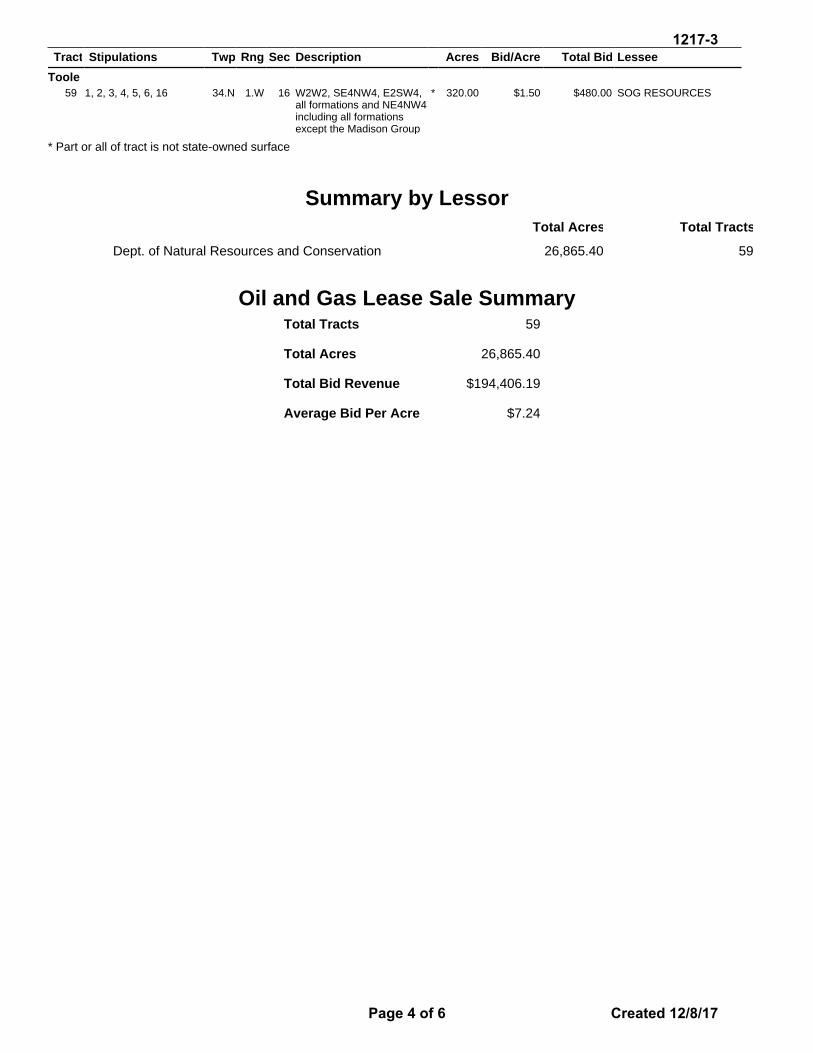
all formations and NE4NW4 including all formations except the Madison Group
* 320.00 $1.50 $480.00 SOG RESOURCES
* Part or all of tract is not state-owned surface
Summary by LessorTotal Acres Total Tracts
Dept. of Natural Resources and Conservation 26,865.40 59
Oil and Gas Lease Sale SummaryTotal Tracts
Total Acres
Total Bid Revenue
Average Bid Per Acre
59
26,865.40
$194,406.19
$7.24
1217-3
Page 4 of 6 Created 12/8/17

1 Lessee shall notify and obtain approval from the Department's Trust Land Management Division (TLMD) prior to constructing well pads, roads, power lines, and related facilities that may require surface disturbance on the tract. Lessee shall comply with any mitigation measures stipulated in TLMD's approval.
2 Prior to the drilling of any well on or into the lease premises, lessee shall send one copy of the well prognosis, including Form 22 "Application for Permit" to the Department's Trust Land Management Division (TLMD). After a well is drilled and completed, lessee shall send one copy of all logs run, Form 4A "Completion Report", and geologic report to TLMD. A copy of Form 2 "Sundry Notice and Report of Wells" or other appropriate Board of Oil and Gas Conservation form shall be sent to TLMD whenever any subsequent change in well status or operator is intended or has occurred. Lessee shall also notify and obtain approval from the TLMD prior to plugging a well on the lease premises.
Issuance of this lease in no way commits the Land Board to approval of coal bed methane production on this lease. Any coal bed methane extraction wells would require subsequent review and approval by the board.
3 The TLMD will complete an initial review for cultural resources and, where applicable, paleontological resources of the area intended for disturbance and may require a resources inventory. Based on the results of the inventory, the TLMD may restrict surface activity for the purpose of protecting significant resources located on the lease premises.
4 The lessee shall be responsible for controlling any noxious weeds introduced by lessee's activity on State-owned land and shall prevent or eradicate the spread of those noxious weeds onto land adjoining the lease premises. The lessee’s methods of control shall be reviewed and approved by the Department’s Unit Office that has jurisdiction for that locale.
5 The definitions of "oil" and "gas" provided in 82-1-111, MCA, do not apply to this lease for royalty calculation purposes.
6 If the State does not own the surface, the lessee must contact the owner of the surface in writing at least 30 days prior to any surface activity. A copy of the correspondence shall be sent to TLMD.
7 Due to unstable soil conditions on this tract and/or topography that is rough and/or steep, surface use may be restricted or denied. Seismic activity may be restricted to poltershots.
8 The lessee is responsible to pay for all damages, including penalties and charges assessed by the USDA-CFSA on CRP lands, as a result of drilling and production on the tract.
9 This lease is located within designated sage grouse general habitat. Proposed activities are subject to, and shall comply with, all provisions, stipulations and mitigation requirements of the Montana Sage Grouse Habitat Conservation Strategy, as implemented by Governor's Executive Orders 10-2014, 12-2015, and amendments thereto. Contact the TLMD prior to preparing a project proposal.
10 This lease is located within designated sage grouse core habitat. Proposed activities are subject to, and shall comply with, all provisions, stipulations and mitigation requirements of the Montana Sage Grouse Habitat Conservation Strategy, as implemented by Governor's Executive Orders 10-2014, 12-2015, and amendments thereto. Contact the TLMD prior to preparing a project proposal.
11 Unless otherwise approved by the Department in writing, wells and related surface infrastructure, including new road construction, are prohibited within 1/2 mile of the centerline of a navigable river, lake or reservoir, and within 1/4 mile of direct perennial tributary streams of navigable waterways, on or adjacent to the tract. No surface occupancy is allowed within the bed of a river, stream, lake or reservoir, islands and accretions or abandoned channels.
12 Due to the floodplain/wetlands area(s), surface use may be restricted or denied.
State of MontanaOil & Gas Lease Sale - December 5, 2017
Stipulations
1217-3
Page 5 of 6 Created 12/8/17

13 Any activity within 1/8 mile of the river, stream, floodplain, or lake/reservoir on or adjacent to this tract must be approved in writing by the TLMD prior to commencement. No surface occupancy is allowed within the bed of the river and/or stream, abandoned channels, the bed of the lake/reservoir, or on islands and accretions associated with the river, stream, or lake/reservoir.
14 This tract contains navigable riverbeds. No surface occupancy is allowed within the bed of the navigable river, abandoned channels, or on islands and accretions. In addition, upon completion of a successful well, where river title is disputed, the lessee will file an interpleader action under Rule 22, M.R.Civ.P. in the Montana District Court, or other court having jurisdiction, in which the leased lands are located for all acreage within the lease in which the title is disputed. The lessee shall name all potential royalty claimants as defendants.
15 If the lessee completes a successful oil and/or gas well, and if land title is disputed, the lessee shall fund professional land surveys as needed to determine the location and acreage encompassed by the spacing and/or pooling unit and the state lease acreage within that unit. Surveys shall be conducted by a licensed land surveyor acceptable to the Department, and shall be prepared pursuant to survey requirements provided by the Department.
16 This tract has (an) existing well(s) and related facilities. The lessee has 45 days from the effective date of this lease to determine whether or not to assume responsibility from the former lessee for the well(s) and any existing facilities. The lessee may not enter the well(s) until a change of operator has been filed with, and approved by, the Board of Oil and Gas Conservation. The(se) well(s) must be returned to commercial production or plugged and the well site(s) reclaimed within 18 months from the effective date of this lease.
17 Lessee shall avoid gravel permit areas and shall contact and coordinate with the gravel permittee and TLMD regarding proposed oil and gas activities. No surface occupancy of the permitted gravel operations is allowed without written approval of TLMD.
18 If whooping cranes are observed on-site, construction and/or maintenance activities shall be suspended until birds leave the area.
1217-3
Page 6 of 6 Created 12/8/17

1217-4 INFORMATIONAL ITEM:
BIENNIAL CABIN SITE LEASE RATE REVIEW (SEPTEMBER 2015 – SEPTEMBER 2017)

Land Board Agenda Informational Item December 18, 2017
1217-4 Informational Item: Biennial Cabin Site Lease Rate Review (September 2015 – September 2017)
Location: Beaverhead, Big Horn, Blaine, Broadwater, Cascade, Choteau, Custer, Daniels, Fallon, Fergus, Flathead, Gallatin, Golden Valley, Hill, Judith Basin, Lake, Lewis & Clark, Lincoln, Madison, McCone, Meagher, Mineral, Missoula, Musselshell, Phillips, Pondera, Powder River, Powell, Prairie, Richland, Rosebud, Sanders, Sheridan, Stillwater, Sweet Grass, Toole, Valley, Wheatland, Wibaux, Yellowstone Counties
Trust Benefits: Common Schools, School for Deaf & Blind, Montana State University, Montana Tech, Pine Hills School, Public Buildings, University of Montana, Veterans Home, Eastern College–MSU/Western College– UM
Trust Revenue: N/A
Item Summary
The Trust Lands Management Division (TLMD) is required to provide to the Land Board a review of cabin site lease rates every two years. The review includes data from all cabin site lease bids within the two-year period and a review of the data by an economist.
This review requirement was established in September 2015 through a settlement agreement to a civil suit (Montrust III).
Lease Rates
(as established in the settlement agreement) New Bidding: Cabin site leases on unleased lots are issued through a competitive bidding process. The bid rate is a percentage of the Department of Revenue (DOR) land value, and the bid amount is the first year’s lease fee. • 6.5%: All initial bidding starts at 6.5% for 60 days;• 5.0%: The rate may be reduced to 5% for an additional 60 days.• Less than 5%: The rate may be incrementally reduced after bidding has been
unsuccessful at 6.5% and 5%, only in neighborhoods with vacancy rates over 30%.• Minimums: Minimum Rate is 3.5%, and the minimum annual rent is $800.Renewals:All cabin site leases have a right to renew upon expiration without competitive bidding.• 5%: All renewals are offered at 5% of the land value.• Minimums: The annual rent shall never be below $800.
Background (Cabin Site Lease Rate Legislation and Litigation)
1983: HB 391 set fee values at 5% of the Lease value of the property. Lessees protested and legislative negotiations adjusted the rate to a 3.5% lease rate.
1989: SB 226 attempted to clarify the 3.5% into law with the final language reading: 77-1-208, MCA, 1(a) “the fee must be 3.5% of the appraised value of the cabin site”.
1217-4
Page 1 of 11 Updated 12/12/17

1993: SB 424 eliminated the 3.5% annual lease rate, substituting the language now in statute: (1) The board shall set the annual fee based on full market value of each site as determined by department of revenue appraisal.
1999: Montanans for Responsible Use of School Trust (Montrust) filed suit against the Land Board and the Department of Natural Resources and Conservation (DNRC) challenging that the 3.5% was “significantly below fair market value”, and prevailed. This ruling was rooted in Article X of the Montana Constitution. Following the 1999 decision, in 2000 the Land Board adopted a new 5% lease rate to be phased in over 5 years.
2008: The DOR appraisals increased dramatically from the previous appraisal cycle for most cabin site leases, resulting in significant, unprecedented increases in lease fees. In anticipation of vacancies and resulting loss in revenue due to the fee increase, DNRC and the Land Board adopted a compromise policy (entitled Alternative 3B) which uses 5% of an adjusted appraised value based on the average appreciation of state leases, and increased annually by a Lease Fee Indicator, which is limited to a minimum of 3.25% and maximum of 6.5%.
2011: SB409 directed DNRC to institute an open competitive bidding process for currently vacant lots with an initial minimum bid level of 2% of appraised value. It was passed by the legislature and became law without the Governor’s signature.
2012: Judge Jeffery Sherlock (Helena District Court) enjoined DNRC from instituting the new leasing rules promulgated under SB409. Montrust III is the name of the civil suit that was initiated by Montrust in 2012 against the State of Montana, Land Board, and DNRC. Montrust was joined by the Board of Regents as Intervenor-Plaintiff, and DNRC was joined by Montana State Leaseholder’s Association as Intervenor-Defendant. The Plaintiffs alleged that the administrative rules regarding lease fee calculation methods for cabin and home site leases on state trust land violated the fiduciary, trust, and constitutional duties of the State of Montana, the Land Board, and DNRC, and failed to secure for the trust a full market value rate of return. Montrust III alleged that the rules related to both SB409 and Alternative 3B created lease fees below full market value.
2015: A Settlement Agreement to resolve Montrust III was executed between all four parties, approved by the Land Board, and subsequently approved by the District Court. DNRC then adopted Administrative Rules to implement the settlement agreement in June 2016.
Settlement Agreement Key Points (and subsequent ARM 36.25.1001-36.25.1021) • Voided all rules implementing SB409 (2011) and the lease fee calculations of
Alternative 3B. • Provided that all current leases remain in place until expiration. • Established lease fee rates for renewals at 5%, and lease fee rates for new bidding
will be adjustable based on vacancy rates (between 6.5% and 3.5%). • The minimum annual lease fee for all renewals and/or new bidding will be $800. • Lease bid rates will be reviewed by the Land Board every two years.
Summary Between September 2015 and September 2017, DNRC renewed 30 leases at 5% and conducted five rounds of competitive bidding. Although DNRC could not start competitive bidding until June 2016 when Administrative Rules were finalized, the department received a record number of bids and a general heightened interest in the leasing program during the 15 months of bidding: 29 bids were received for 26 lots, and to date 22 competitively bid leases have been executed.
1217-4
Page 2 of 11 Updated 12/12/17

Montana State Trust Lands Cabin Site Lease Rate Review 2017
Background
The settlement agreement reached in 2015 between MonTrust and the Board of Regents, and the DNRC
and MT State Leaseholders Association stipulated that the results of implementing the settlement would
be reviewed and considered by the Land Board every two years. In June of 2016, the Department
finalized new Administrative Rules (ARM 36.25.1001-36.25.2021) for cabin site leasing
implementing the terms of the settlement. All new bidding shall start at 6.5% of the
Department of Revenue (DOR) value for the land, and after 60 days, the minimum bid may be
reduced to 5%. Additionally, the ARM allows for the minimum bid rate to be further reduced
after 60 days of bidding at 5%, for neighborhoods with high vacancy rates (30% or higher).
Implementation
Upon adoption of the ARM to implement the settlement, DNRC made vacant cabin sites available for
bid. The first round of bidding set minimum annual lease rates at 6.5% of the 2014 appraised lot values,
and opened in June 2016. In following rounds of bidding, the minimum bid rate was set at 5% for most
sites, however minimum bid rates for sites in high-vacancy neighborhoods (more than 30% of lots
vacant) continued to drop. The rates and results are summarized in Table 1, and more detail is shown in
Exhibit A. These bidding cycles spanned roughly one year, and 29 bids were received on 26 lots.
Table 1. Summary of Bids on Vacant Cabinsites
Bidding Period Minimum Bid Rate
Lots Posted
Bids Received
Average Bid Rate
Portion of Posted Lots
Receiving Bids
Lots with More Than
1 Bid
June-August 2016 6.50% 76 6 7% 7.9% 0
August-October 2016 5.00% 63 2 5.15% 3.2% 0
December-January 2017 5% or 4.5% 58 5 5.60% 8.6% 0
March-May 2017 5% or 4.5% 62 4 4.78% 6.5% 0
June-July 2017 5% or 4.0% 65 12 4.60% 13.8% 3
Total over first 5 Bidding rounds: 76 29 5.43% 30% 3
~bid rates lower than 5% only set for neighborhoods with >30% vacancy. Lots with no previous bidding cycles set at 6.5%
1217-4
Page 3 of 11 Updated 12/12/17

Program Vacancy and Competitive Bidding Results
Over the time frame from
June 2016 through the end
of September 2017, 21 new
leases were signed as a
result of the bidding
process, with 1 additional
new lease pending
signature. The 22 new
leases produced in the first 5
rounds of bidding, out of an
average of 65 advertised
sites, suggests an annual
absorption rate of
approximately 30%. Over
the same time frame, 13
existing leases were
terminated for non-payment. Bidding results shown in Table 2 reveal that McGregor Lake was
the only neighborhood to show an increased vacancy. While one new competitively bid lease
was completed, McGregor also had one new lease termination. The cause of the rising vacancy
rate in McGregor Lake is purely due to 4 active sites being sold and dropped from the inventory
used to calculate vacancy. This is a good illustration of the impact to vacancy rates of selling
mostly actively leased sites. Net of the 13 new vacancies, 9 new leases is a net annual
absorption rate of 13.9%. At this absorption rate, it would take roughly 7 years to approach
zero vacancy. The next Rate Review in two years should show whether this pace is realistic.
The cumulative results of new
competitive bidding since the new
leasing rules were implemented are
consistent with the ideal market lease
rates identified in recent studies of
the market for residential lease sites.
The most recent study of Montana
cabin sites found the true full market
lease rate should fall between 4.9%
and 8.6% (Bioeconomics 2015.)
Table 2. Neighborhood Bidding Summary
Neighborhood
Average Bid
Received
Average Bid
Amount
Count of
Bids
Vacancy at June
2016 Start of Bidding
Vacancy as of
September 15, 2017
Beaver Lake 5.0% $8,255 6 47% 25%
Central Remote 8.0% $12,501 1 14% 7%
E. Flathead Lake – Blue Bay 5.4% $2,667 3 42% 38%
Echo Lake 4.4% $11,701 5 41% 37%
Lincoln Flats 6.2% $2,601 2 6% 6%
McGregor Lake 5.2% $15,050 1 50% 58%
Olney 6.8% $2,000 1 3% 0%
Rogers Lake 5.2% $6,410 6 72% 65%
Stillwater/Libby Remote 6.1% $2,235 3 13% 7%
Kalispell Remote 5.1% $6,000 1 24% 24%
Grand Total 5.4% $6,964 29 14% statewide
14% statewide
Chart 1. Average Bid Received by Neighborhood
Beaver Lake (6)
Central Remote (1)
E. Flathead Lake – Blue Bay (3)
Echo Lake(5)
Lincoln Flats (2)
McGregor Lake (1)
Olney (1)
Rogers Lake(6)
Stillwater/Libby Remote (3)
Kalispell
$0
$2,000
$4,000
$6,000
$8,000
$10,000
$12,000
$14,000
$16,000
2.0% 4.0% 6.0% 8.0%
Bid
Am
ou
nt
Bid Received as Lease Rate
Competitive Lease Bids ReceivedJune 2016 - September 2017
1217-4
Page 4 of 11 Updated 12/12/17

Currently active cabin site leases are billed according to four distinct lease fee calculation
methods, until all contracts have been renewed on the new template. The average lease rate
across all active leases in 2017, when comparing 2017 contract rent with the appraised values
applied, is 5.15%. Details are shown in Exhibit B.
Data from non-family transfers of improvements on active leases since the 2015 rate analysis
(Bioeconomics, Cabin Site Lease Rate Valuation Analysis: 2015 Addendum to 2011 Report,
2015) were analyzed using the same model as the 2015 report followed. The sale price
received by lessees for their improvements was compared to the MT Department of Revenue’s
assessed value of the improvements. (Details are shown in Exhibit C.) A wide range of
differences are found, with some selling under value and some gaining a profit (Leasehold
Value) over the assessed value. The Leasehold Value is used in calculating what a full market
lease rate would be, and from 2015 – 2017 this implicit lease rate averaged 5.75%. While lower
than the mean implicit rate over the 2011-2014 years of 6.7%, this is consistent with the full
market rates identified by Bioeconomics (2011 and 2015 update.)
Table 3. Implicit Market Lease Rate: Nonfamily lease transfers, 2015-2017
Year Average Implied Market
Lease Rate Non-family Transfers of
Leases with Improvements
2015 5.81% 18
2016 6.26% 7
2017 5.03% 6
2015-2017 Average/Total
5.75% 31
Assuming ongoing rounds of competitive bidding continue to produce similar results, the vacancy rates in most neighborhoods should fall over the next 1-2 years. However, the legislatively mandated cabin site sales program is reducing the inventory and as DNRC divests of active lease sites, this effectively pushes the vacancy percentage higher in neighborhoods with multiple sales. Given the opposing effects of new leases and selling active leases on vacancy rates, it may be several more years before the leasing program reaches some form of equilibrium vacancy rate. Table 4 shows a simple comparison of statewide vacancy data from June 2016 to September 2017 and illustrates the effect selling active leases has on countering the new leasing activity to hold vacancy rates high when compared to the working inventory. Table 4. Total Working Cabin Site Inventory and Sales/Vacancy Rate
Active Vacant Working Inventory Sold Vacancy Rate
June 2016 654 106 760 39 13.95%
September 2017 614 98 712 71 13.76%
1217-4
Page 5 of 11 Updated 12/12/17

While the vacancy rate remains in the 12 – 14% range, as it has since 2013 when the main
impacts of large cabin site rent increases related to the 2008 appraisal cycle had leveled off,
Chart 2 illustrates that the higher vacancy rate has not resulted in falling program revenues.
During the years prior to the settlement in
2015, competitive bidding happened with a
minimum bid of 5% and relatively few new
leases were signed. Results from calendar
year 2012 through 2015 are provided in
Table 5. The numbers suggest that the
bidding activity for cabin sites on state land
has increased dramatically. The exact cause of the increased activity is difficult to measure;
improved housing markets may play a part but the change may also be due to a measure of
stability returning to the leasing program since reaching the final 2015 settlement agreement.
Chart 2. Cabin Sites 10 Year Revenue and Vacancy Rate
Table 5. Competitive Bidding in Recent Years
Bidding PeriodMinimum Bid
Rate
Competitively Bid
Leases Signed
2012 5.00% 6
2013 5.00% 6
2014 5.00% 2
2015 5.00% 4
Total over Calender Years 2012-2015: 18
1217-4
Page 6 of 11 Updated 12/12/17

Conclusion and Recommendation
The results of competitive bids received (average 5.4%) and of sales of improvements through
non-family lease transfers (mean implicit market rate of 5.75%) are indicative of a market for
cabin site leasing which can continue to support a 5% or higher lease rate. However, these
competitive bidding data only represent one year. DNRC recommends continuing to hold
minimum bids for vacant sites in low-vacancy neighborhoods at or above 5%, while recognizing
that several high vacancy (greater than 30%) neighborhoods persist and there are still a large
number of vacant sites which have received no bids through several rounds of bidding.
1217-4
Page 7 of 11 Updated 12/12/17
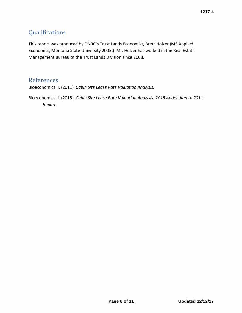
Qualifications
This report was produced by DNRC’s Trust Lands Economist, Brett Holzer (MS Applied
Economics, Montana State University 2005.) Mr. Holzer has worked in the Real Estate
Management Bureau of the Trust Lands Division since 2008.
References Bioeconomics, I. (2011). Cabin Site Lease Rate Valuation Analysis.
Bioeconomics, I. (2015). Cabin Site Lease Rate Valuation Analysis: 2015 Addendum to 2011
Report.
1217-4
Page 8 of 11 Updated 12/12/17

Exhibit A: Results of Competitive Bidding for Cabin Sites
Lease Number Unit NeighborhoodMinimum
Bid RateBid Amount
Actual
Bid RateImprovements
3071958 Boz Central Remote 6.50% $12,501 8% Yes3053160 STU Stillwater/Libby Remote 6.50% $2,200 7.50% Yes3052018 STU Beaver Lake (Lot 42) 6.50% $12,000 7.10% Yes
3052764 KU Rogers Lake (Lot 33) 6.50% $6,200 6.60%Yes – Bidder is former lessee
3052590 KU Rogers Lake (Lot 34) 6.50% $7,700 6.50%Yes – Bidder is former lessee
3052911 STU Olney (Lot 19) 6.50% $2,000 6.80% No
Lease Number Unit NeighborhoodMinimum
Bid RateBid Amount
Actual
Bid RateImprovements
3051988 KU McGregor Lake (Lot 27) 5% $15,050 5.20% Yes3052438 KU Rogers Lake (Lot 18) 5% $6,300 5.10% Yes
Lease Number Unit NeighborhoodMinimum
Bid RateBid Amount
Actual
Bid RateImprovements
3053274 KU E. Flathead Lake – Blue Bay (Lot 22) $2,601 5.50% No
3052867 KU E. Flathead Lake – Blue Bay (Lot 13) $2,601 5.60% No
3062397 CLW Lincoln Flats (Lot 23) $2,601 6.25% Yes
3062688 CLW Lincoln Flats (Lot 14) $2,601 6.20% No
3052658 STW Beaver Lake (Lot 18) $7,225 4.50% Yes
Lease Number Unit NeighborhoodMinimum
Bid RateBid Amount
Actual
Bid RateImprovements
3052449 STW Beaver Lake (Lot 10) 5% $8,510 5% No
3053306 KU E. Flathead Lake – Blue Bay (Lot 23) 5% $2,800 5.10% No
3051564 KU Echo Lake (Lot 35) 4.50% $12,850 4.50% Yes
3052841 KU Rogers Lake (Lot 6) 4.50% $3,525 4.50% Yes
Lease Number Unit NeighborhoodMinimum
Bid RateBid Amount
Actual
Bid RateImprovements
$12,500 5%
$11,002 4.40%
3053396 KU Echo Lake (Lot 20) 4% $11,675.50 4.20% No – Demo3051587 KU Echo Lake (Lot 38) 4% $10,476 4% Yes – Trust
$8,215 5%
$6,700 4.10%3052642 STU Beaver Lake (Lot 11A) 4% $6,880 4% Yes – Private3052572 KU Rogers Lake (Lot 2) 4% $6,021 4.10% Yes – Trust 3052806 KU Rogers Lake (Lot 26) 4.50% $8,712 4.50% Yes – Private
3053037 KU Woods Bay (Lot 2) 5% $6,000 5.10%Yes – Pending through 8/9
$2,424 5.80%
$2,080 5%5%
Average Bid Rate: 4.6%
Average Bid Rate: 4.78%
4%‐6.5% MINIMUM BID RATES based on neighborhood vacancy
Bidding: Opened June 1, 2017 – Closed July 31, 2017
Yes – Private3053099 STU Stillwater Remote (Lot 1)
Average Bid Rate: 5.6%
4.5%‐5% MINIMUM BID RATES based on neighborhood vacancy
Bidding: Opened March 2017 – Closed May 1, 2017
4%
4%
3052598 STU Beaver Lake (Lot 5) Yes – Trust
3051552 KU Echo Lake (Lot 28) Yes – Private
Average Bid Rate: 7%
Bidding: Opened June 2016 – Closed August 2016
6.5% MINIMUM BID RATE for all available leases
Bidding: Opened December 2016 – Closed January 2017
4.5%‐5% MINIMUM BID RATES based on neighborhood vacancy
Average Bid Rate: 5.15%
Bidding: Opened August 2016 – Closed October 2016
5% MINIMUM BID RATE for all available leases
1217-4
Page 9 of 11 Updated 12/12/17

ExhibitB:SummaryofDNRCCabinsiteLotValuesand2017RentsasaPercentofLotValue
Billing Method
Alternative 3B 5% of Appraised Value Annual 2% Increase Fixed (Minimum)
Total
Average
2014
Value
Total 2017
Rent‐ Avg
Percent of
Value
Neighborhoods by Land Area
Average
2014
Value
2017 Rent‐
Avg Percent
of Value
Average
2014
Value
2017 Rent‐
Avg Percent
of Value
Average
2014
Value
2017 Rent‐
Avg Percent
of Value
Average
2014 Value
2017 Rent‐
Avg Percent
of Value
CLO
Central Remote $64,099 4.92% $35,880 5.00% $152,270 5.80% $74,679 5.05%
CLO Total $64,099 4.92% $35,880 5.00% $152,270 5.80% $74,679 5.05%
ELO
Eastern Remote $21,441 1.72% $20,934 5.00% $35,940 5.00% $5,719 24.21% $18,795 9.40%
ELO Total $21,441 1.72% $20,934 5.00% $35,940 5.00% $5,719 24.21% $18,795 9.40%
NELO
NorthEast Remote $20,096 4.81% $17,193 5.00% $23,895 5.00% $10,488 8.05% $19,507 5.05%
NELO Total $20,096 4.81% $17,193 5.00% $23,895 5.00% $10,488 8.05% $19,507 5.05%
NWLO
Ashley Creek $36,281 8.91% $36,281 8.91%
Beaver Lake $177,044 5.76% $166,700 4.69% $173,350 5.38%
E Lake Shore ‐ Flathead $320,395 5.48% $44,276 5.00% $46,341 5.61% $283,717 5.45%
Echo Lake $284,999 4.43% $188,910 5.00% $265,950 4.50% $269,298 4.52%
Fishtrap Creek $18,757 2.29% $15,742 5.00% $18,087 2.89%
Kalispell Remote $68,544 6.35% $66,800 5.00% $50,781 5.00% $67,460 6.20%
Libby Creek $50,600 5.00% $50,600 5.00%
McGregor lake $299,200 3.98% $288,400 5.32% $298,120 4.12%
Mudd Creek $22,290 2.42% $21,622 5.00% $22,190 2.80%
Olney Region $36,935 3.87% $43,950 5.00% $29,594 6.89% $36,926 3.99%
Plains Remote $19,797 2.84% $18,342 4.75% $19,297 3.50%
Rogers Lake $99,467 10.28% $131,800 4.36% $107,550 8.80%
Stillwater‐Libby Remote $37,644 6.22% $27,950 6.32% $36,260 6.23%
Thompson Creek $24,270 2.05% $15,931 5.00% $18,711 4.02%
NWLO Total $105,169 4.72% $44,093 4.89% $146,927 5.03% $101,315 4.76%
SLO
Southern Remote $27,033 7.46% $39,056 5.00% $28,750 7.11%
SLO Total $27,033 7.46% $39,056 5.00% $28,750 7.11%
SWLO
Clearwater River Eastside $64,393 4.03% $75,515 5.00% $85,556 5.10% $65,756 4.13%
Clearwater River Westside $82,231 4.26% $81,261 5.00% $82,143 4.33%
Elbow Lake $72,467 5.38% $81,216 5.00% $80,890 5.00% $75,893 5.23%
Fish Creek $13,842 8.32% $14,490 5.00% $16,662 5.00% $14,046 5.70% $14,596 5.79%
Grant Creek $90,296 5.30% $90,296 5.30%
Lincoln Flats ‐ Lincoln Area $42,338 5.81% $41,612 5.00% $42,302 5.77%
Morrell Creek East $29,629 5.42% $42,941 5.00% $34,954 5.25%
Morrell Creek West $39,511 3.78% $33,766 5.00% $36,064 4.51%
Morrell Flats $51,947 5.13% $48,504 5.00% $42,185 5.00% $48,812 5.03%
Placid Lake $243,160 4.74% $246,686 5.00% $245,144 5.05% $246,198 4.98%
Seeley Lake Development $51,922 3.83% $103,491 5.00% $58,576 3.98%
Seeley Lake East Outlet $76,108 8.42% $64,427 5.00% $55,103 5.00% $70,352 6.83%
Seeley Lake North $53,742 3.62% $52,991 5.00% $53,242 4.54%
Seeley Lake West Outlet $73,906 8.94% $65,751 5.00% $70,644 7.36%
SouthWest Remote $42,039 7.25% $63,384 5.00% $54,541 5.00% $50,543 6.25%
Sperry Grade $89,330 5.01% $89,330 5.01%
SWLO Total $66,042 5.27% $112,679 5.00% $103,153 5.03% $14,046 5.70% $82,031 5.18%
Grand Total $74,713 4.99% $90,168 4.98% $108,344 5.10% $9,292 14.04% $78,975 5.15%
1217-4
Page 10 of 11 Updated 12/12/17

Exhibit C: Non-Family Cabin Site Transfers, 2015-2017.
Transfer Date Neighborhood
Selling Price
Cadastral Value-
Improve-ments
Leaseholder Value
Cadastral Land Value
Leaseholder Value / Land
Value
Implied Market Lease Rate
6/4/2015 LincolnGulch $6,000 $17,031 -$11,031 $41,500 -26.58% 4.21%
9/8/2017 Beaver Lake $85,000 $68,270 $16,730 $173,000 9.67% 7.45%
1/1/2017 Central Remote $140,000 $148,260 -$8,260 $54,200 -15.24% 6.86%
6/19/2017 Central Remote $2,401 $61,930 -$59,529 $157,264 -37.85% 2.27%
2/12/2015 Clearwater River Eastside $55,000 $48,340 $6,660 $51,437 12.95% 4.04%
10/2/2015 Clearwater River Eastside $30,000 $1,250 $28,750 $84,713 33.94% 5.43%
6/30/2016 Clearwater River Eastside $41,000 $6,390 $34,610 $50,130 69.04% 6.38%
7/6/2016 Echo Lake $40,000 $30,090 $9,910 $270,945 3.66% 3.29%
5/29/2015 Elbow Lake $90,000 $35,240 $54,760 $81,943 66.83% 7.17%
7/16/2015 Elbow Lake $59,000 $49,410 $9,590 $78,055 12.29% 4.99%
12/9/2016 Elbow Lake $173,000 $71,850 $101,150 $81,781 123.68% 9.70%
1/21/2016 Grant Creek $277,000 $231,080 $45,920 $90,296 50.85% 6.99%
12/9/2015 Kalispell Remote $25,000 $4,380 $20,620 $92,300 22.34% 4.55%
12/23/2015 Lincoln Flats $40,000 $30,340 $9,660 $42,115 22.94% 6.12%
8/24/2015 Morrell Flats $61,500 $47,740 $13,760 $20,347 67.63% 7.76%
6/8/2016 Morrell Flats $47,000 $55,180 -$8,180 $40,068 -20.42% 4.15%
3/24/2017 Morrell Flats $70,000 $26,300 $43,700 $115,550 37.82% 3.26%
1/5/2015 Mudd Creek $58,000 $27,770 $30,230 $26,326 114.83% 6.56%
8/6/2015 Mudd Creek $38,000 $30,030 $7,970 $23,869 33.39% 3.50%
2/10/2015 Placid Lake $77,500 $52,226 $25,274 $251,224 10.06% 3.96%
3/3/2015 Seeley Lake Development $68,000 $76,071 -$8,071 $52,820 -15.28% 3.08%
8/7/2015 Seeley Lake Development $14,000 $26,690 -$12,690 $54,530 -23.27% 4.14%
8/31/2015 Seeley Lake Development $34,500 $27,400 $7,100 $54,340 13.07% 3.95%
6/6/2016 Seeley Lake Development $300,000 $106,460 $193,540 $252,197 76.74% 7.92%
8/1/2016 Seeley Lake Development $37,000 $26,590 $10,410 $44,311 23.49% 4.97%
4/24/2017 Seeley Lake Development $10,000 $35,000 -$25,000 $50,270 -49.73% 2.72%
11/3/2015 Seeley Lake East Outlet $259,000 $74,550 $184,450 $88,285 208.93% 14.43%
6/5/2015 Seeley Lake West Outlet $250,000 $91,094 $158,906 $87,119 182.40% 14.00%
1/26/2017 SouthWest Remote $160,000 $161,410 -$1,410 $53,874 -2.62% 4.93%
9/23/2015 Sperry Grade $35,000 $39,590 -$4,590 $93,656 -4.90% 4.64%
7/29/2016 Sperry Grade $107,000 $60,380 $46,620 $83,482 55.84% 6.68%
7/22/2015 Stillwater-Libby Remote $20,000 $41,790 -$21,790 $43,950 -49.58% 1.97%
6/8/2017 Stillwater-Libby Remote $12,000 $860 $11,140 $34,700 32.10% 7.69%
1217-4
Page 11 of 11 Updated 12/12/17

1217-5 EASEMENTS


Land Board Agenda Item December 18, 2017
1217-5 Easements
Location: Cascade, Chouteau, Dawson, Flathead, Lewis & Clark, Missoula, Park, Toole, Yellowstone
Trust Benefits: Common Schools, Montana Tech, Public Buildings, Public Land Trust, Veteran’s Home
Trust Revenue: Common Schools=$11,974 Montana Tech=$976 Public Buildings=$2,092 Public Land Trust=$11,779 Veteran’s Home=$14,000
Item Table of Contents
Applicant Right-of-Way Purpose Term Page(s) Northwestern Energy Historic Utility Permanent 1-29Northwestern Energy New Utility Permanent 30-31City of Shelby New Storm Water Ditch Permanent 32-34Triangle Telephone Coop. Assn., Inc. New Telecommunications Utility Permanent 35-38CHS, Inc. New Outfall Structure Permanent 39-41Mid-Rivers Telephone Cooperative New Telecommunications Utility Permanent 42-43
1217-5
Created 12/8/17

Rights of Way Applications
December 18, 2017 APPLICANTS AND RIGHTS OF WAY INFORMATION_____
Applicant: Northwestern Energy 11 East Park Butte, MT 59701
Application No.: 17400 R/W Purpose: a 100kV overhead electric transmission line Lessee Agreement: N/A (Historic) Acreage: 0.28 Compensation: $1598.00 Legal Description: 30-foot strip across the Clark Fork River in NE4SE4, Sec. 21
& NW4SW4, Sec. 22, Twp. 13N, Rge. 19W, MissoulaCounty
Trust Beneficiary: Public Land Trust
Item Summary
Northwestern Energy has made application for multiple overhead electric distribution and transmission lines and natural gas pipelines that were constructed on state lands many years ago without proper authorization from the Land Board. Pursuant to §77-1-130, MCA, Northwestern Energy is requesting recognition of these overhead electric distribution and transmission lines and natural gas pipelines as historic rights of ways
DNRC Recommendation
The director recommends approval of this historic right of way for Northwestern Energy. ______________________________________________________________
1
1217-5
Created 12/8/17

Rights of Way Applications
December 18, 2017
APPLICANTS AND RIGHTS OF WAY INFORMATION_____ Applicant: Northwestern Energy 11 East Park Butte, MT 59701 Application No.: 17401 R/W Purpose: a 10.75” buried natural gas pipeline Lessee Agreement: N/A (Historic) Acreage: 0.31 Compensation: $1705.00 Legal Description: 50-foot strip across the Flathead River in SW4SW4, Sec. 6 &
NW4NW4, Sec. 7, Twp. 30N, Rge. 19W, Flathead County Trust Beneficiary: Public Land Trust Item Summary See page 1 DNRC Recommendation See page 1 ______________________________________________________________
2
1217-5
Created 12/8/17

Rights of Way Applications
December 18, 2017
APPLICANTS AND RIGHTS OF WAY INFORMATION_____ Applicant: Northwestern Energy 11 East Park Butte, MT 59701 Application No.: 17432 R/W Purpose: a 7.2Kv overhead electric transmission line Lessee Agreement: N/A (Historic) Acreage: 0.2 Compensation: $475.00 Legal Description: 10-foot strip across the Clark Fork River in N2NE4, Sec. 1,
Twp. 13N, Rge. 21W & SE4SE4, Sec. 36, Twp. 14N, Rge. 21W, Missoula County
Trust Beneficiary: Public Land Trust and Common Schools Item Summary See page 1 DNRC Recommendation See page 1 ______________________________________________________________
3
1217-5
Created 12/8/17

Rights of Way Applications
December 18, 2017
APPLICANTS AND RIGHTS OF WAY INFORMATION_____ Applicant: Northwestern Energy 11 East Park Butte, MT 59701 Application No.: 17434 R/W Purpose: a 7.2kV overhead electric distribution line Lessee Agreement: N/A (Historic) Acreage: 0.11 Compensation: $857.00 Legal Description: 10-foot strip across the Bitterroot river in N2SW4, Sec. 26,
Twp. 13N, Rge. 20W, Missoula County Trust Beneficiary: Public Land Trust & Common Schools Item Summary See page 1 DNRC Recommendation See page 1 ______________________________________________________________
4
1217-5
Created 12/8/17

Rights of Way Applications
December 18, 2017
APPLICANTS AND RIGHTS OF WAY INFORMATION_____ Applicant: Northwestern Energy 11 East Park Butte, MT 59701 Application No.: 17439 R/W Purpose: a 4” natural gas pipeline Lessee Agreement: N/A (Historic) Acreage: 0.14 Compensation: $799.00 Legal Description: 20-foot strip across the Bitterroot River in N2SW4, Sec. 26,
Twp. 13N, Rge. 20W, Missoula County Trust Beneficiary: Public Land Trust Item Summary See page 1 DNRC Recommendation See page 1 ______________________________________________________________
5
1217-5
Created 12/8/17

Rights of Way Applications
December 18, 2017
APPLICANTS AND RIGHTS OF WAY INFORMATION_____ Applicant: Northwestern Energy 11 East Park Butte, MT 59701 Application No.: 17459 R/W Purpose: a 4” buried natural gas pipeline Lessee Agreement: N/A (Historic) Acreage: 1.4 Compensation: $14,000 Legal Description: 20-foot strip through E2SW4, Sec. 18, Twp. 30N, Rge. 20W,
Flathead County Trust Beneficiary: Veteran’s Home Item Summary See page 1 DNRC Recommendation See page 1 ______________________________________________________________
6
1217-5
Created 12/8/17

Rights of Way Applications
December 18, 2017
APPLICANTS AND RIGHTS OF WAY INFORMATION_____ Applicant: Northwestern Energy 11 East Park Butte, MT 59701 Application No.: 17463 R/W Purpose: a 6” natural gas pipeline Lessee Agreement: N/A (Historic) Acreage: 0.04 Compensation: $300.00 Legal Description: 20-foot strip across the Stillwater River in NW4NW4, Sec.
31, Twp. 29N, Rge. 21W, Flathead County Trust Beneficiary: Public Land Trust Item Summary See page 1 DNRC Recommendation See page 1 ______________________________________________________________
7
1217-5
Created 12/8/17

Rights of Way Applications
December 18, 2017
APPLICANTS AND RIGHTS OF WAY INFORMATION_____ Applicant: Northwestern Energy 11 East Park Butte, MT 59701 Application No.: 17464 R/W Purpose: an 8” natural gas pipeline Lessee Agreement: N/A (Historic) Acreage: 0.06 Compensation: $3000.00 Legal Description: 30-foot strip across the Swan River in NE4SE4, Sec. 36,
Twp. 27N, Rge. 20W, Flathead County Trust Beneficiary: Public Land Trust Item Summary See page 1 DNRC Recommendation See page 1 ______________________________________________________________
8
1217-5
Created 12/8/17

Rights of Way Applications
December 18, 2017
APPLICANTS AND RIGHTS OF WAY INFORMATION_____ Applicant: Northwestern Energy 11 East Park Butte, MT 59701 Application No.: 17466 R/W Purpose: a 4” natural gas pipeline Lessee Agreement: N/A (Historic) Acreage: 0.02 Compensation: $150.00 Legal Description: 20-foot strip across the Whitefish River in SE4NW4, Sec. 32,
Twp. 29N, Rge. 21W, Flathead County Trust Beneficiary: Public Land Trust Item Summary See page 1 DNRC Recommendation See page 1 ______________________________________________________________
9
1217-5
Created 12/8/17

Rights of Way Applications
December 18, 2017 APPLICANTS AND RIGHTS OF WAY INFORMATION_____ Applicant: Northwestern Energy 11 East Park Butte, MT 59701 Application No.: 17467 R/W Purpose: a 4” buried natural gas pipeline Lessee Agreement: N/A (Historic) Acreage: 0.06 Compensation: $255.00 Legal Description: 20-foot strip across the Whitefish River in SE4SE4, Sec. 36,
Twp. 31N, Rge. 22W, Flathead County Trust Beneficiary: Public Land Trust Item Summary See page 1 DNRC Recommendation See page 1 ______________________________________________________________
10
1217-5
Created 12/8/17

Rights of Way Applications
December 18, 2017
APPLICANTS AND RIGHTS OF WAY INFORMATION_____ Applicant: Northwestern Energy 11 East Park Butte, MT 59701 Application No.: 17468 R/W Purpose: a 4” natural gas pipeline Lessee Agreement: N/A (Historic) Acreage: 0.02 Compensation: $150.00 Legal Description: 20-foot strip across the Whitefish River in SW4SE4, Sec. 29,
Twp. 29N, Rge. 21W, Flathead County Trust Beneficiary: Public Land Trust Item Summary See page 1 DNRC Recommendation See page 1 ______________________________________________________________
11
1217-5
Created 12/8/17

Rights of Way Applications
December 18, 2017
APPLICANTS AND RIGHTS OF WAY INFORMATION_____ Applicant: Northwestern Energy 11 East Park Butte, MT 59701 Application No.: 17470 R/W Purpose: a 10.75” buried natural gas pipeline Lessee Agreement: N/A (Historic) Acreage: 0.06 Compensation: $450.00 Legal Description: 50-foot strip across the Whitefish River in SE4NE4,
NE4SE4, Sec. 5, Twp. 28N, Rge. 21W, Flathead County Trust Beneficiary: Public Land Trust Item Summary See page 1 DNRC Recommendation See page 1 ______________________________________________________________
12
1217-5
Created 12/8/17

Rights of Way Applications
December 18, 2017
APPLICANTS AND RIGHTS OF WAY INFORMATION_____ Applicant: Northwestern Energy 11 East Park Butte, MT 59701 Application No.: 17985 R/W Purpose: a 12.47kV overhead electric distribution line Lessee Agreement: N/A (Historic) Acreage: 0.16 Compensation: $288.00 Legal Description: 10-foot strip across the Missouri River in NW4NW4, Sec. 5,
Twp. 19N, Rge. 3E & SW4SW4, Sec. 32, Twp. 20N, Rge. 3E, Cascade County
Trust Beneficiary: Public Land Trust Item Summary See page 1 DNRC Recommendation See page 1 ______________________________________________________________
13
1217-5
Created 12/8/17

Rights of Way Applications
December 18, 2017
APPLICANTS AND RIGHTS OF WAY INFORMATION_____ Applicant: Northwestern Energy 11 East Park Butte, MT 59701 Application No.: 17987 R/W Purpose: a 12.47kV overhead electric distribution line Lessee Agreement: N/A (Historic) Acreage: 0.13 Compensation: $163.00 Legal Description: 10-foot strip across the Missouri River in NE4NW4, Sec. 10,
Twp. 19N, Rge. 3E, Cascade County Trust Beneficiary: Public Land Trust Item Summary See page 1 DNRC Recommendation See page 1 ______________________________________________________________
14
1217-5
Created 12/8/17

Rights of Way Applications
December 18, 2017
APPLICANTS AND RIGHTS OF WAY INFORMATION_____ Applicant: Northwestern Energy 11 East Park Butte, MT 59701 Application No.: 18004 R/W Purpose: a 12.47kV overhead electric distribution line Lessee Agreement: N/A (Historic) Acreage: 4.13 Compensation: $2478.00 Legal Description: 30-foot strip through SE4NE4, E2SE4, SW4SE4, Sec. 19 &
N2NW4, S2NW4, NW4NE4, Sec. 30, Twp. 19N, Rge. 3W, Cascade County
Trust Beneficiary: Common Schools Item Summary See page 1 DNRC Recommendation See page 1 ______________________________________________________________
15
1217-5
Created 12/8/17

Rights of Way Applications
December 18, 2017
APPLICANTS AND RIGHTS OF WAY INFORMATION_____ Applicant: Northwestern Energy 11 East Park Butte, MT 59701 Application No.: 18006 R/W Purpose: a 12.47kv overhead electric distribution line Lessee Agreement: N/A (Historic) Acreage: 0.65 Compensation: $390.00 Legal Description: 30-foot strip through NW4SE4, Sec. 26, Twp. 19N, Rge. 4W,
Lewis & Clark County Trust Beneficiary: Common Schools Item Summary See page 1 DNRC Recommendation See page 1 ______________________________________________________________
16
1217-5
Created 12/8/17

Rights of Way Applications
December 18, 2017
APPLICANTS AND RIGHTS OF WAY INFORMATION_____ Applicant: Northwestern Energy 11 East Park Butte, MT 59701 Application No.: 18007 R/W Purpose: a 24.94kV overhead electric distribution line Lessee Agreement: N/A (Historic) Acreage: 0.97 Compensation: $776.00 Legal Description: 30-foot strip through SE4SW4, Sec. 17, Twp. 20N, Rge. 2E,
Cascade County Trust Beneficiary: Montana Tech Item Summary See page 1 DNRC Recommendation See page 1 ______________________________________________________________
17
1217-5
Created 12/8/17

Rights of Way Applications
December 18, 2017
APPLICANTS AND RIGHTS OF WAY INFORMATION_____ Applicant: Northwestern Energy 11 East Park Butte, MT 59701 Application No.: 18008 R/W Purpose: a 24.94kV overhead electric distribution line Lessee Agreement: N/A (Historic) Acreage: 0.25 Compensation: $200.00 Legal Description: 30-foot strip through SW4NW4, Sec. 20, Twp. 20N, Rge. 2E,
Cascade County Trust Beneficiary: Montana Tech Item Summary See page 1 DNRC Recommendation See page 1 ______________________________________________________________
18
1217-5
Created 12/8/17

Rights of Way Applications
December 18, 2017
APPLICANTS AND RIGHTS OF WAY INFORMATION_____ Applicant: Northwestern Energy 11 East Park Butte, MT 59701 Application No.: 18009 R/W Purpose: a 100kV overhead electric transmission line Lessee Agreement: N/A (Historic) Acreage: 0.19 Compensation: $262.00 Legal Description: 30-foot strip across the Sun River in SE4NE4, N2SE4, Sec.
1, Twp. 20N, Rge. 2E, Cascade County Trust Beneficiary: Public Land Trust Item Summary See page 1 DNRC Recommendation See page 1 ______________________________________________________________
19
1217-5
Created 12/8/17

Rights of Way Applications
December 18, 2017 APPLICANTS AND RIGHTS OF WAY INFORMATION_____ Applicant: Northwestern Energy 11 East Park Butte, MT 59701 Application No.: 18025 R/W Purpose: a 12.47kV overhead electric distribution line Lessee Agreement: N/A (Historic) Acreage: 2.64 Compensation: $924.00 Legal Description: 30-foot strip through N2NE4, SE4NE4, Sec. 33, Twp. 24N,
Rge. 9E, Chouteau County Trust Beneficiary: Common Schools Item Summary See page 1 DNRC Recommendation See page 1 ______________________________________________________________
20
1217-5
Created 12/8/17

Rights of Way Applications
December 18, 2017 APPLICANTS AND RIGHTS OF WAY INFORMATION_____ Applicant: Northwestern Energy 11 East Park Butte, MT 59701 Application No.: 18026 R/W Purpose: a 12.47kV overhead electric distribution line Lessee Agreement: N/A (Historic) Acreage: 3.82 Compensation: $3820.00 Legal Description: 30-foot strip through S2NW4, NE4SW4, N2SE4, Sec. 34,
Twp. 24N, Rge. 9E, Chouteau County Trust Beneficiary: Common Schools Item Summary See page 1 DNRC Recommendation See page 1 ______________________________________________________________
21
1217-5
Created 12/8/17

Rights of Way Applications
December 18, 2017 APPLICANTS AND RIGHTS OF WAY INFORMATION_____ Applicant: Northwestern Energy 11 East Park Butte, MT 59701 Application No.: 18027 R/W Purpose: a 12.47kV overhead electric distribution line Lessee Agreement: N/A (Historic) Acreage: 0.27 Compensation: $270.00 Legal Description: 30-foot strip through SE4SE4, Sec. 16, Twp. 24N, Rge. 10E,
Chouteau County Trust Beneficiary: Common Schools Item Summary See page 1 DNRC Recommendation See page 1 ______________________________________________________________
22
1217-5
Created 12/8/17

Rights of Way Applications
December 18, 2017 APPLICANTS AND RIGHTS OF WAY INFORMATION_____ Applicant: Northwestern Energy 11 East Park Butte, MT 59701 Application No.: 18028 R/W Purpose: a 12.47kV overhead electric distribution line Lessee Agreement: N/A (Historic) Acreage: 0.07 Compensation: $1070.00 Legal Description: 30-foot strip through SW4SW4, Sec. 17, Twp. 24N, Rge.
11E, Chouteau County Trust Beneficiary: Common Schools Item Summary See page 1 DNRC Recommendation See page 1 ______________________________________________________________
23
1217-5
Created 12/8/17

Rights of Way Applications
December 18, 2017
Application #s 17400, 17432, 17434, 17439 – Northwestern Energy
24
1217-5
Created 12/8/17

Rights of Way Applications
December 18, 2017
Application #s 17401, 17459, 17463, 17466 – 17468 – Northwestern Energy
25
1217-5
Created 12/8/17

Rights of Way Applications
December 18, 2017
Application #s 17464 & 17470 – Northwestern Energy
26
1217-5
Created 12/8/17

Rights of Way Applications
December 18, 2017
Application #s 17985, 17987, 18007 – 18009 – Northwestern Energy
27
1217-5
Created 12/8/17

Rights of Way Applications
December 18, 2017
Application #s 18004 & 18006 – Northwestern Energy
28
1217-5
Created 12/8/17

Rights of Way Applications
December 18, 2017
Application #s 18025 – 18028 – Northwestern Energy
29
1217-5
Created 12/8/17
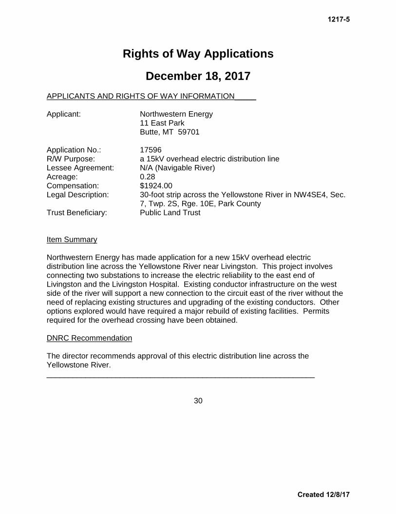
Rights of Way Applications
December 18, 2017 APPLICANTS AND RIGHTS OF WAY INFORMATION_____ Applicant: Northwestern Energy 11 East Park Butte, MT 59701 Application No.: 17596 R/W Purpose: a 15kV overhead electric distribution line Lessee Agreement: N/A (Navigable River) Acreage: 0.28 Compensation: $1924.00 Legal Description: 30-foot strip across the Yellowstone River in NW4SE4, Sec.
7, Twp. 2S, Rge. 10E, Park County Trust Beneficiary: Public Land Trust Item Summary Northwestern Energy has made application for a new 15kV overhead electric distribution line across the Yellowstone River near Livingston. This project involves connecting two substations to increase the electric reliability to the east end of Livingston and the Livingston Hospital. Existing conductor infrastructure on the west side of the river will support a new connection to the circuit east of the river without the need of replacing existing structures and upgrading of the existing conductors. Other options explored would have required a major rebuild of existing facilities. Permits required for the overhead crossing have been obtained. DNRC Recommendation The director recommends approval of this electric distribution line across the Yellowstone River. ______________________________________________________________
30
1217-5
Created 12/8/17

Rights of Way Applications
December 18, 2017
Application # 17596 – Northwestern Energy
31
Livingston
Easement
Easement
1217-5
Created 12/8/17

Rights of Way Applications
December 18, 2017 APPLICANTS AND RIGHTS OF WAY INFORMATION_____ Applicant: City of Shelby 112 1st Street South Shelby, MT 59474 Application No.: 18123 R/W Purpose: construction and maintenance of a storm water ditch Lessee Agreement: ok Acreage: 0.61 Compensation: $1891.00 Legal Description: Four tracts of land within NW4SE4, Sec. 27, Twp. 32N, Rge.
2W, Toole County Trust Beneficiary: Public Buildings Item Summary The City of Shelby has made application for the construction and maintenance of a storm water ditch to serve the City of Shelby and is associated with proposed storm water improvements for the City. The purpose is to provide general drainage for the City’s storm water system. The proposed alignment parallels the rail road tracks in the City and follows an existing storm water ditch. Occupancy permits needed from BNSF have been obtained. DNRC Recommendation The director recommends approval of this storm water ditch. ______________________________________________________________
32
1217-5
Created 12/8/17

Rights of Way Applications
December 18, 2017
Application # 18123 City of Shelby Vicinity Map
33
Easement Area
1217-5
Created 12/8/17

Rights of Way Applications
December 18, 2017
Application # 18123 – City of Shelby 34
1217-5
Created 12/8/17

Rights of Way Applications
December 18, 2017 APPLICANTS AND RIGHTS OF WAY INFORMATION_____ Applicant: Triangle Telephone Coop. Assn., Inc. PO Box 1220 Havre, MT 59501 Application No.: 18124 R/W Purpose: a buried telecommunications cable Lessee Agreement: ok Acreage: 1.21 Compensation: $1089.00 Legal Description: 20-foot strip through W2W2 of Lots 4 & 5, Sec. 6, Twp. 30N,
Rge. 13E, Hill County Trust Beneficiary: Common Schools Item Summary Triangle Telephone Cooperative Association, Inc., has made application to install new underground telecommunications facilities to upgrade their current facilities and services to the Box Elder Exchange serving area in and around Box Elder, MT. These improvements will offer state-of-the-art telecommunications toll and distribution facilities, as well as future growth capabilities. The proposed route was determined as the most direct route between terminus locations while also providing access to existing and future network considerations. This route will provide accessibility for construction and maintenance since it is located primarily along existing roadways. DNRC Recommendation The director recommends approval of this buried telecommunications cable. ______________________________________________________________
35
1217-5
Created 12/8/17

Rights of Way Applications
December 18, 2017
Application # 18124 – Triangle Telephone
36
Easement
Easement
1217-5
Created 12/8/17

Rights of Way Applications
December 18, 2017 APPLICANTS AND RIGHTS OF WAY INFORMATION_____ Applicant: Triangle Telephone Coop. Assn., Inc. PO Box 1220 Havre, MT 59501 Application No.: 18125 R/W Purpose: a buried telecommunications cable Lessee Agreement: ok Acreage: 0.67 Compensation: $201.00 Legal Description: 20-foot strip through NE4NW4, Sec. 27, Twp. 33N, Rge.
14E, Hill County Trust Beneficiary: Public Buildings Item Summary Triangle Telephone Cooperative Association, Inc., has made application to install new underground telecommunications facilities to upgrade their current facilities and services to the Simpson Exchange serving area north of Havre, MT. These improvements will offer state-of-the-art telecommunications toll and distribution facilities, as well as future growth capabilities. The proposed route was determined as the most direct route between terminus locations while also providing access to existing and future network considerations. This route will provide accessibility for construction and maintenance since it is located primarily along existing roadways. DNRC Recommendation The director recommends approval of this buried telecommunications cable. ______________________________________________________________
37
1217-5
Created 12/8/17
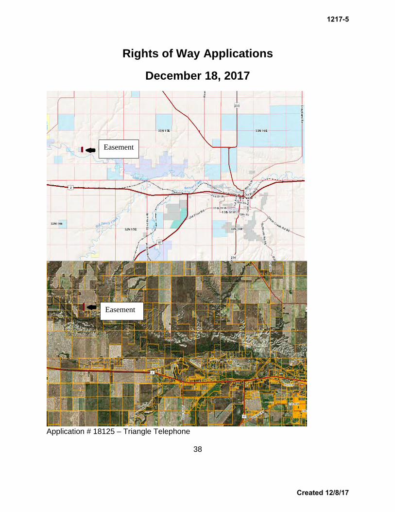
Rights of Way Applications
December 18, 2017
Application # 18125 – Triangle Telephone
38
Easement
Easement
1217-5
Created 12/8/17

Rights of Way Applications
December 18, 2017
APPLICANTS AND RIGHTS OF WAY INFORMATION_____ Applicant: CHS, Inc. PO Box 909 Laurel, MT 59044 Application No.: 18127 R/W Purpose: an outfall discharge structure Lessee Agreement: N/A (Navigable River) Acreage: 0.12 Compensation: $100.00 Legal Description: tract of land in Government Lot 3 in the Yellowstone River,
Sec. 15, Twp. 2S, Rge. 24E, Yellowstone County Trust Beneficiary: Public Land Trust Item Summary Cenex Harvest States, Inc., has made application for an outfall discharge structure in the Yellowstone River. The outfall structure will be located on a parcel owned by the City of Laurel, adjacent and downstream of the Billings Bench Water Association intake structure; on the bank of the river just below the low water mark. This structure must be located in close proximity to the river to utilize the approved mixing zone, reduce potential for bank/channel erosion, and meet design requirements. Further, the new structure is necessary to achieve the discharge requirements set in the MPDES (Montana Pollutant Discharge Elimination System) permit; permit # MT0000264. DNRC Recommendation The director recommends approval of this outfall structure in the Yellowstone River. ______________________________________________________________
39
1217-5
Created 12/8/17

Rights of Way Applications
December 18, 2017
Application # 18127 – CHS, Inc.
40
Easement
1217-5
Created 12/8/17

Rights of Way Applications
December 18, 2017
Application # 18127 – CHS
41
Sewage Disposal Flume
Easement/Outfall Structure
1217-5
Created 12/8/17

Rights of Way Applications
December 18, 2017
APPLICANTS AND RIGHTS OF WAY INFORMATION_____ Applicant: Mid-Rivers Telephone Cooperative PO Box 280 Circle, MT 59215 Application No.: 18128 R/W Purpose: a buried telecommunications cable Lessee Agreement: ok Acreage: 3.09 Compensation: $1236.00 Legal Description: 16-foot strip through S2SW4, NE4SW4, N2SE4, E2NE4,
Sec. 36, Twp. 17N, Rge. 51E, Dawson County Trust Beneficiary: Common Schools Item Summary Mid-Rivers Telephone Cooperative has made application to install a new buried telecommunications cable. This project is located in Lindsay, MT and is anticipated to begin the spring of 2018. This alignment was chosen to follow existing communications utilities and the existing traveled way. Other routes were considered and eliminated for topographical, environmental and economic reasons. The line will be constructed using the rip/trench static plow method. DNRC Recommendation The director recommends approval of this buried telecommunications cable. ______________________________________________________________
42
1217-5
Created 12/8/17

Rights of Way Applications
December 18, 2017
Application # 18128 – Mid-Rivers Telephone Cooperative
43
Easement
Glendive
1217-5
Created 12/8/17

1217-6 INFORMATIONAL ITEM:
FOREST INSECT AND DISEASE UPDATE

Land Board Agenda Item December 18, 2017
1217-6 Informational Item: Forest Insect and Disease Update
Location: N/A Trust Benefits: N/A Trust Revenue: N/A
Item Summary
The Department of Natural Resources and Conservation (DNRC) will present an update to the Land Board on the general state and health of forested state trust lands.
1217-6
Page 1 of 1 Created 12/8/17