agriculture and the environment - roger blench ghana -agriculture.pdf · comparison with other...
TRANSCRIPT

AGRICULTURE and the ENVIRONMENT
IN
NORTHEASTERN GHANA:
A COMPARISON OF HIGH AND MEDIUM POPULATION DENSITY AREAS
CIRCULATION DRAFT
Working Paper: ‘Partnerships and Policies for change’
N.B. This working paper was eventually published in shortened form in Blench, R.M. 1999. Agriculture and the environment in northeastern Ghana: a comparison of high and medium population density areas. In: R.M. Blench (ed.) Natural Resource Management and Socio-economic Factors in Ghana. 21-43. London: Overseas Development Institute.
I am no longer working at ODI and current contact details are;
Roger Blench Mallam Dendo 8, Guest Road Cambridge CB1 2AL United Kingdom Voice/ Fax. 0044-(0)1223-560687 Mobile worldwide (00-44)-(0)7967-696804 E-mail [email protected] http://www.rogerblench.info/RBOP.htm
This version: Cambridge, November, 06
This paper is distributed by ODI, an independent, non-profit policy research institute, with financial support from the Department for International Development. Opinions expressed do not necessarily reflect the views either of ODI or the Department for International Development.

i
TABLE OF CONTENTS
TABLES ........................................................................................................................................................ ii FIGURES ...................................................................................................................................................... ii APPENDIX TABLES................................................................................................................................... ii MAPS............................................................................................................................................................. ii 1. Introduction ........................................................................................................................................... 1
1.1 Background........................................................................................................................................... 1 1.2 Survey Background and Methodology ................................................................................................. 3
2. Ecological Background...................................................................................................................... 4 2.1 Rainfall and climate.............................................................................................................................. 4 2.2 Soils ...................................................................................................................................................... 4 2.3 Vegetation............................................................................................................................................. 5
3. Administrative Background .............................................................................................................. 5 3.1 Administrative structures...................................................................................................................... 5 3.2 Reserved land ....................................................................................................................................... 6
4. Populations, social structure and land tenure ........................................................................... 7 4.1 Language and ethnicity......................................................................................................................... 7 4.2 Social structure ..................................................................................................................................... 7 Characteristics of households .................................................................................................................... 9 4.3 Religion .............................................................................................................................................. 10 4.4 Land tenure......................................................................................................................................... 11 4.5 Distribution of population .................................................................................................................. 12 4.6 Labour migration and its consequences.............................................................................................. 13 4.7 Human population: nutrition and disease ........................................................................................... 13
5. Agricultural systems ......................................................................................................................... 14 5.1 Existing research on agriculture ......................................................................................................... 14 5.2 Systems of cultivation ........................................................................................................................ 15
5.2.1 Rainfed ........................................................................................................................................................15 5.2.2 Irrigated .......................................................................................................................................................15
5.3 Crops................................................................................................................................................... 16 5.3.1 Crop Species and Varieties..........................................................................................................................16 5.3.2 Change in the cultigen repertoire.................................................................................................................16
5.4 Trees in farms and trees in the bush .................................................................................................. 17 5.5 Soil and water conservation................................................................................................................ 18 5.6 Farm inputs ......................................................................................................................................... 18 5.7 Tillage................................................................................................................................................. 19
Animal Traction....................................................................................................................................................19 5.8 Crop damage....................................................................................................................................... 21
Elephants ..............................................................................................................................................................21 6. Livestock systems ............................................................................................................................. 21 7. Exploitation of bush resources ...................................................................................................... 24
7.1 Plant products ..................................................................................................................................... 24 7.2 Hunting ............................................................................................................................................... 25 7.3 Fishing ................................................................................................................................................ 25 7.4 Gold-mining ....................................................................................................................................... 25
8. Pressure on the environment ......................................................................................................... 26 9. Developers at work ........................................................................................................................... 27
9.1 Government, Multilateral and bilateral aid agencies .......................................................................... 27 9.2 NGOs.................................................................................................................................................. 28
10. Policy implications .......................................................................................................................... 28 10.1 Land use planning: genesis and evolution........................................................................................ 29 10.2 Decentralisation and Forest Reserves................................................................................................. 29 10.3 Maintaining biodiversity.................................................................................................................... 30

ii
References.................................................................................................................................................... 34
TABLES
Table 1 . Sample sizes of socio-economic survey........................................................................................ 3 Table 2. Size and structure of households in NE Ghana........................................................................... 9 Table 3. Religious affiliation of respondents ............................................................................................ 10 Table 4. Economic trees left on farms....................................................................................................... 17 Table 5. Percentage of farmers using different inputs ............................................................................ 19 Table 6. Incidence of animal traction and tillage strategies ................................................................... 20 Table 7. Incidence of livestock ownership by species .............................................................................. 21 Table 8. Regional inequalities in incidence of livestock ownership........................................................ 22 Table 9. Principal species of economic tree .............................................................................................. 25 Table 10. Percentage of farmers using different types of fuel ............................................................... 26
FIGURES Figure 1. Languages spoken in the villages surveyed................................................................................ 7 Figure 2. Religious affiliation of respondents.......................................................................................... 10 Figure 3. Percentage farmers using input types ...................................................................................... 19 Figure 4. Pattern of Livestock ownership in NE Ghana ......................................................................... 22 Figure 5. Regional differences in livestock ownership ............................................................................ 23 Figure 6. Percentage farmers using different types of fuel ..................................................................... 27
APPENDIX TABLES Appendix Table 1. Peoples and Languages of Northeastern Ghana...................................................... 31 Appendix Table 2. Crops cultivated in Northern Ghana........................................................................ 32 Appendix Table 3. Fruit trees left in fields cleared for cultivation ........................................................ 33
MAPS Map 1. Ghana showing location of survey area ............................................................................................. 2 Map 2. Detail of the survey area in NE Ghana............................................................................................... 4

iii
Currency
The currency of GHANA is 1 Cedi = 100 pesewas. As of November, 06 1000 cedis (c/) was worth US 11c.
Acronyms
FWRMP Forestry and Wildlife Resource Management Project LPA Land Planning Area MOFA Ministry of Forestry and Agriculture NAES Nyankpala Agricultural Experimental Station NGO Non-Governmental Organisation NR Northern Region RFO Regional Forestry Officer SARI Savanna Agricultural Research Institute UER Upper East Region UWR Upper West Region WAS West African Shorthorn (cattle)
iv
SUMMARY 1. Agricultural systems in NE Ghana represent a striking contrast between the relatively low-density
systems on the east-central region (Northern Region) and the extremely high densities of the extreme north-east (Upper East Region). The reasons for this division appear to be largely historical but the practical consequences for Natural Resource Management are poorly understood.
2. Research was conducted in NE Ghana from 10/2/97 to 18/3/97 following a preliminary visit in June
1996. The research was conducted under a memorandum of understanding with the Forestry Department with the practical support of Planning Branch, Kumasi and the RFOs in Tamale and Bolgatanga.
3. High human population densities and the consequent pressure on the land have had significant effects
on all natural resource sectors, and consequent impacts on social structures. Most notable are the elimination of almost all trees in farms in the Upper East Region (UER), with resulting soil erosion and poor fertility. This has placed very high pressure on reserved forest areas leading to local conflict. The absence of firewood means that cereal stalks are burnt for fuel, and hence do not return to the soil.
4. Lower population densities in the Northern Region have the consequence that livestock holdings and
the role of livestock in subsistence is greatly increased. Crop yields are higher and family and traditional political structures more stable. The consequence of high densities and seasonal nutritional deficits in the UER has been to accelerate labour migration, affecting the cohesion of communities and the consequent viability of farm enterprises.
5. Environmental degradation in the Northern Savanna of Ghana would appear to be well advanced by
comparison with other countries in the Sudano-Sahelian zone. The reasons for this would appear to be;
a) Frequent widespread bush fires b) Uncontrolled firewood cutting and charcoal production c) Absence of restraints on animal browsing d) The removal of trees to increase cropping space e) High human population density in some areas
The precise contribution of these factors is disputed, but there is little doubt that in the case of a-d) a more
effective tradition of enforcement in Francophone countries has resulted in improved environmental conservation.
6. Government and NGO responses have historically been two; the establishment of Forest Reserves and
the planting of woodlots, community nurseries etc. Attempts to manage the very much larger savannah woodland resource have been very limited. Yet it is this resource which is of greatest concern to farmers and of greatest overall value to the national economy.
7. Ghana will devolve increasing power to Regional and District Assemblies in the coming years. One
element of this will place control over natural resources in the hands of these bodies. Given the political pressure that will be exercised by farmers desperate for access to the remaining reserved areas, only a powerful land use planning exercise, implemented early in the new regime, is likely to preserve the balance of human population and natural resources.

1
Although the system of agriculture is “fixed”… it leaves much to be desired. Farming methods have not been adjusted to keep pace with the growth in intensity of conditions. Farming is regarded as a custom and not as a business, with the result that in crop production and in animal husbandry the maximum is left to nature.
Lynn 1937:10
Before the arrival of industrial farm inputs in the 1960s, Sisala farmers practised swidden horticulture. They used no fertiliser and irrigation. … They used the metal-tipped, hand-held short hoe and bush-knife as their main tools. Production was at a subsistence level.
Mendonsa 1980:276
Yet production in this region has continuously been characterized by low productivity.. Several factors contribute to the low productivity in this sector. Prominent among these are;
i) the dominance of the traditional hand-hoe technique for tilling the land ii) the seasonal shortages of labour which result from the unfavourable and unpredictable
climatic conditions iii) the low fertility of the soil iv) lack of improved technologies for rainfed cereal crops
Panin 1986:1
Recent agricultural survey data from a relatively densely populated locality within the Guinea savannah zone of northern Ghana is analysed. This data suggests that, in spite of very low yield-levels obtained, most smallholders currently farm using little or no fertiliser, other purchased inputs and ploughing services.
Warner (1996: Executive summary)
1. Introduction 1.1 Background The above quotations, spanning some sixty years of studies of agriculture in Northern Ghana suggest a rather unfortunate conclusion; that little or nothing has changed over this period, despite the best efforts of developers. This cannot be entirely true, of course, since animal traction has become established in the region and at least some cash-crops are grown. Yet it probably embodies an important truth, namely that for the great mass of subsistence farmers, life has either not changed substantially or else conditions have deteriorated. This is disturbing, if true; northern Ghana has seen both intensive research into agriculture and related problems and considerable efforts at practical development. From the 1920s to the 1950s, this took the form of studies and extension projects initiated by the colonial agricultural department. In the post-Independence years, the impetus came more from projects funded by multi-lateral donor agencies working through the agriculture department. More recently there has been an dramatic growth of NGOs in the region designing and implementing a variety of projects.
Section
11
2
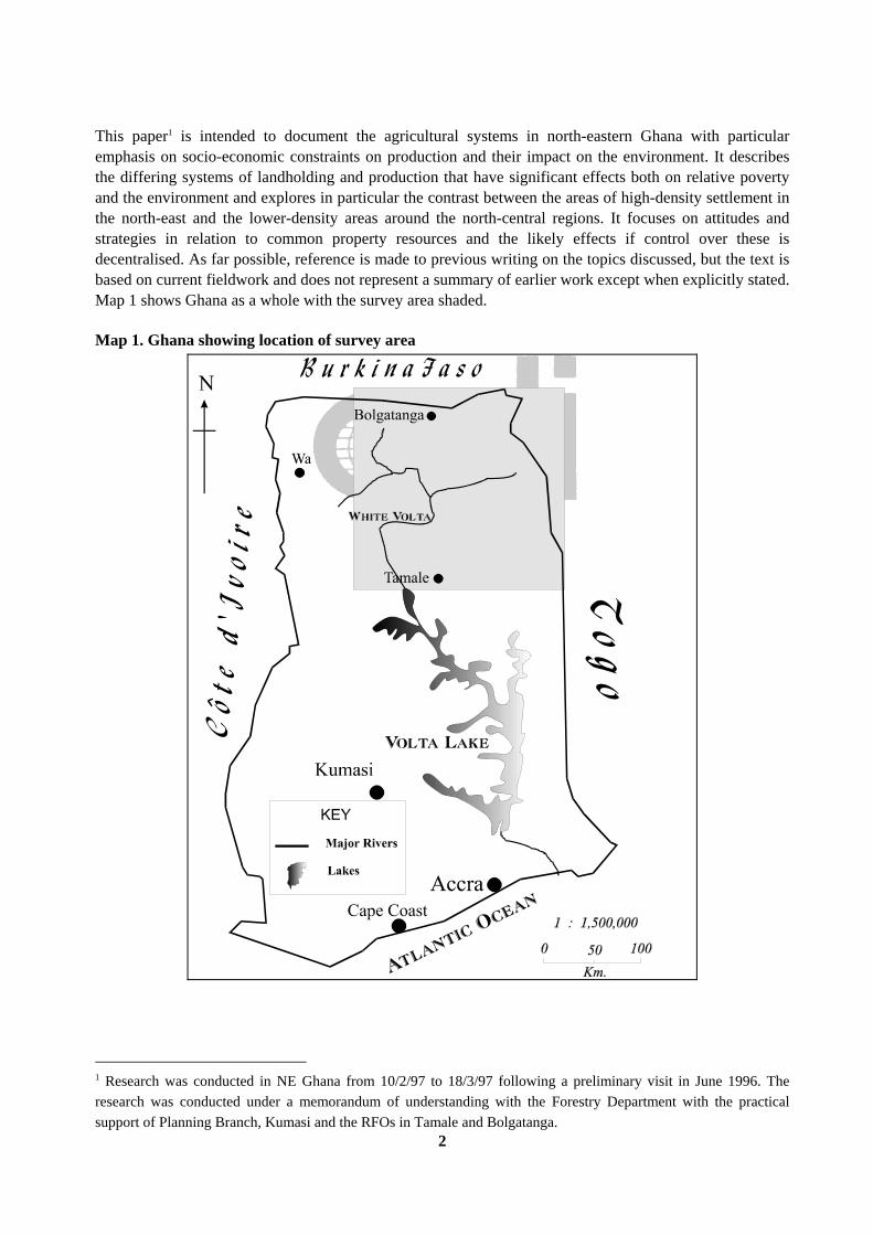
This paper1 is intended to document the agricultural systems in north-eastern Ghana with particular emphasis on socio-economic constraints on production and their impact on the environment. It describes the differing systems of landholding and production that have significant effects both on relative poverty and the environment and explores in particular the contrast between the areas of high-density settlement in the north-east and the lower-density areas around the north-central regions. It focuses on attitudes and strategies in relation to common property resources and the likely effects if control over these is decentralised. As far possible, reference is made to previous writing on the topics discussed, but the text is based on current fieldwork and does not represent a summary of earlier work except when explicitly stated. Map 1 shows Ghana as a whole with the survey area shaded. Map 1. Ghana showing location of survey area
1 Research was conducted in NE Ghana from 10/2/97 to 18/3/97 following a preliminary visit in June 1996. The research was conducted under a memorandum of understanding with the Forestry Department with the practical support of Planning Branch, Kumasi and the RFOs in Tamale and Bolgatanga.

3
1.2 Survey Background and Methodology A baseline socio-economic survey was conducted in Upper East Region and the Tamale area of Northern Region of Ghana in February and March 1997. The survey area is shown in. There were two principal elements, surveys of villages and of individual households. Village surveys were intended to capture qualitative aspects of agricultural and environmental institutions associated with village. The principal survey statistics are as follows (Table 1); Table 1 . Sample sizes of socio-economic survey
Villages Surveyed 42Sacred Groves 179Total Households surveyed 529
Northern 222Upper East 307
Coverage was intended to reflect ecology, settlement and human population density, as well as ecological and ethnolinguistic diversity. The following working paper2 is intended as an overview of the results. The intention is to provide background socio-economic data to assist in the planning process relating to savannah woodland management, especially in the light of the upcoming Forestry and Wildlife Resource Management Project3. The research will be spread over the period 1997-1999. A workshop was held on the 28th of February to both inform Government Officers, representatives of the District and NGOs or preliminary results and to outline the likely course of the project. In parallel, a considerable quantity of 'grey' literature was collected and xeroxed, especially that held at SARI, the Savanna Agricultural Research Institute at Nyankpala. The survey was conducted through the Regional Forestry offices, using initially Technical Officers. However, the languages required often necessitated the recruitment of additional personnel from outside. The primary problem is therefore simply communicating with farmers, and this required a large number of enumerators speaking different languages. 2 I should like to thank the Forestry Department, in particular the Chief Conservator of Forests, Mr. E.O. Nsenkyire, who both eased the initial process of arranging the MOU and took time to discuss the preliminary survey results. The survey could not have been carried out without the practical support of Planning Branch, Kumasi and its Director, Dr. B. Aninakwa. I should like to thank Keith Dolman of the Forest Sector Development Project for smoothing the path of the survey in many ways and Jane Gronow for discussions and assistance with documentation. The RFOs in Tamale and Bolgatanga, at the time Mr. Oppong Sasu and Mr. Winfred Bimah did everything in their power to ease the survey in their area. Mr. Peter Howard, IUCN, kindly supplied documents relating to the wildlife element of FWRMP. 3 The present writer was invited to attend a planning workshop in Kumasi on the 17th of February to discuss the submission of the SWM documentation. A preliminary version of this paper was presented to the Conference 'Ghana and Zimbabwe: Partnerships and Policies for Improved Natural Resource Management' held at ODI in London on the 26-27th of June 1997. I am grateful to the participants at that meeting for many useful comments.
4
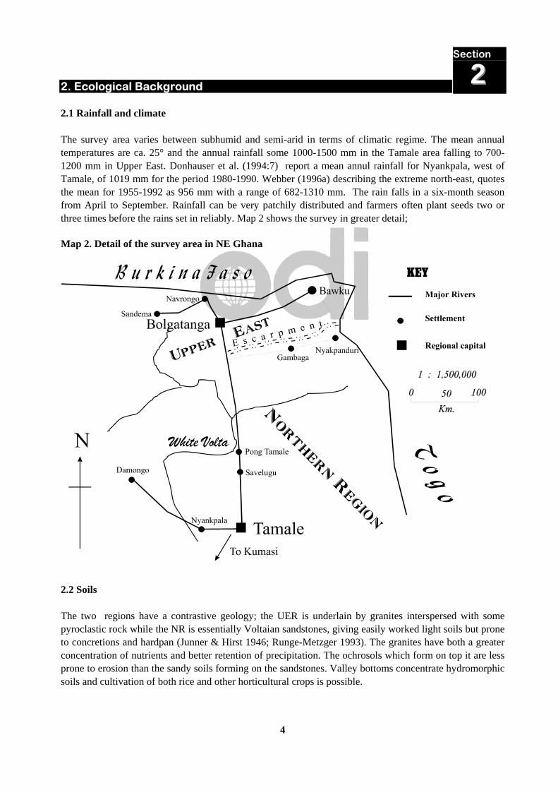
2. Ecological Background 2.1 Rainfall and climate The survey area varies between subhumid and semi-arid in terms of climatic regime. The mean annual temperatures are ca. 25° and the annual rainfall some 1000-1500 mm in the Tamale area falling to 700-1200 mm in Upper East. Donhauser et al. (1994:7) report a mean annul rainfall for Nyankpala, west of Tamale, of 1019 mm for the period 1980-1990. Webber (1996a) describing the extreme north-east, quotes the mean for 1955-1992 as 956 mm with a range of 682-1310 mm. The rain falls in a six-month season from April to September. Rainfall can be very patchily distributed and farmers often plant seeds two or three times before the rains set in reliably. Map 2 shows the survey in greater detail; Map 2. Detail of the survey area in NE Ghana
2.2 Soils The two regions have a contrastive geology; the UER is underlain by granites interspersed with some pyroclastic rock while the NR is essentially Voltaian sandstones, giving easily worked light soils but prone to concretions and hardpan (Junner & Hirst 1946; Runge-Metzger 1993). The granites have both a greater concentration of nutrients and better retention of precipitation. The ochrosols which form on top it are less prone to erosion than the sandy soils forming on the sandstones. Valley bottoms concentrate hydromorphic soils and cultivation of both rice and other horticultural crops is possible.
Section
22
5
Actual soil fertility is determined as much by the exceptional concentrations of population allied with a low-input farming system. Throughout most of UER, except in the extreme west, there are virtually no elements of the system that encourage the return of nutrients to the soil. Livestock roam freely in the dry season, but in the dry season they are taken away from the area to avoid damage to crops and the manure is effectively lost. Most trees, even leguminous ones, have been removed from the farms in order to increase cropping area. Firewood is so short that the stems of cereals are removed from the farms and used to cook food, thus not returning their organic matter. The elimination of almost all types of ground cover leaves the area prone to wind erosion. Within the lower density areas of NR, many of these problems have been avoided. The underlying hardpan makes root development of cereals more problematic and the higher density of trees requires considerably greater labour inputs, but soil fertility is usually not considered a problem, except in the high-density areas west of Tamale. 2.3 Vegetation The usual description of the vegetation is Guinea savannah in the NR, grading into Sudan savanna in the semi-arid region of the UER. The dominant tree species are locust (‘dawadawa’) (Parkia biglobosa), shea (Vitellaria paradoxa) and kapok (Ceiba pentandra) with a ground cover of perennial grasses such as Andropogon gayanus. Further north, the baobab (Adansonia digitata) and whitethorn (Faidherbia albida) become to predominate. However, much of the area is an example of an extreme anthropogenic landscape. The natural tree fauna has been severely depleted; in much of the UER almost every species except Parkia and Vitellaria has been systematically eliminated from the farming areas (Hunter 1967b; see also Kessler 1992 for a description of a similar pattern in neighbouring Burkina Faso). The bush fires that are set every year reduce all the large trees so that even in remote areas, the vegetation may consist of young trees. The only exceptions to this are the sacred groves attached to most villages in the region; these retain a variety of species (Aubréville 1939; Adam 1948; CIPSEG 1993; see also accompanying paper). These groves still maintain considerable diversity of both wildlife and vegetation, but they are under threat, with farmers encroaching on their boundaries every year. 3. Administrative Background 3.1 Administrative structures Northern Ghana is usually held to consist of three regions, Upper East (UER), Upper West (UWR) and Northern Region (NR). Formerly Upper East and Upper West were conjoined into a single Upper Region. In the colonial era the whole of Northern Ghana was known as the Northern Territories (NT). The regions are extremely uneven in geographical extent, but the distribution of population is such that they are more even in terms of overall human population. The regions are in turn divided into districts which is the lowest level at which the national government operates. Government was traditionally centralised in Accra but in the last few years Ghana has embarked upon a bold experiment in devolving power to the regions and districts. Both regions and districts have elected assemblies which have some powers in the provision of public services but as yet are unable to raise major taxes. Innovations deemed to be of national benefit, such as forest and wildlife reserves are beyond their
Section
33

6
powers; they cannot revise legislation relating to them. However, some of the reforms in progress may change this state of affairs. There are essentially four parts of government involved in the administration of agriculture and the environment. These are;
Ministry of Forestry and Agriculture (MOFA) Department of Livestock Department of Forestry Department of Wildlife
Forestry and Agriculture have both regional and district offices throughout Northern Ghana. Wildlife, however, is concentrated in the National Parks, notably the Mole National Park in the west of Northern Region. Livestock is centred on Pong Tamale, some 25 km. north of Tamale. 3.2 Reserved land The concept that land would need to be reserved to prevent incursions from agriculture and counter soil erosion dates back to the earliest excursions of forest officers through this region (Planning Branch 1997). Thompson (1908) made a tour of the entire country and made preliminary recommendations for preservation of woodland against over-exploitation. The first Forest Officers’ Handbook to the Gold Coast was published in 1922 (Chipp 1922) and in the same year McLeod (1922) was recommending the establishment of fuelwood reserves in the proximity of large towns. The end-process of his work was the North Mamprusi Forestry Conference of 1947, where a series of Forest Reserves were established in selected areas along the main watersheds. This process continues to the present although in recent times, Forestry Department activity has been limited to consolidating existing reserves. One of the ironies of reading triumphalist accounts of social forestry with its emphases on community and participation is the extent to which these ideas a prefigured in the colonial era literature, always stereotyped as characteristic of a ‘top-down’ approach. Here is Vigne (1936) writing of the value of community woodland;
The main value of savannah forest is the supply of firewood, timber and grazing and minor products such as thatch, fruits etc. and the ideal would be to have numerous small reserves, accessible to every settlement, owned by the local people and worked on a simple scheme of management, with their goodwill.
Early ‘schedules’ of Reservation are indeed remarkable for their sensitivity to the Forest Reserve as a multi-purpose resource, where communities could graze stock, cut thatch and building poles, retain access to their shrines and gather non-timber products. A Reserve constituted under ‘bylaws’ could encompass an agreement that allowed for all these local factors to be taken into account. However, as human populations increased and the land beyond the reserves began to look more and more desolate, Forest Officers saw it increasingly as their role to prevent the depredations of the adjacent agricultural communities. When a Reserve was constituted under the Forest Ordinance the access of local communities was abrogated as ‘all rights are extinguished’. Administrative documents of the late colonial period saw this process as increasingly necessary (Planning Branch 1997). The consequence was that farmers associated Reserves with a government that had appropriated their land and thus their relationship with forest guards became

7
increasingly antagonistic. This situation has now become a self-fulfilling prophecy. Were the Reserves now opened to the adjacent communities, it seems probable that they would be ravaged within a short time. 4. Populations, social structure and land tenure 4.1 Language and ethnicity Northern Ghana is highly diverse ethnolinguistically, with at least twenty-five languages spoken in the region surveyed (Barker 1984; Kropp-Dakubu 1989). There is no lingua franca that serves as an effective medium of intercommunication although a type of Hausa is often used as a market speech in large towns. This diversity presumably reflects the acephalous social structure characteristic of many peoples of the region. Appendix Table 1 lists all the languages spoken in the region and Figure 1 compares the numbers speaking individual languages in the villages surveyed; Figure 1. Languages spoken in the villages surveyed
0 2 4 6 8 10 12 14 16
Villages speaking this language
Buli
Dagbane
Gurni
Kasem
Kusaal
Nabti
Nankani
Talni
Television broadcasts are put out in Dagbane and Gurni, and six or more languages are used on the radio. Although literacy materials have been prepared in many of these languages, usually through the agency of bible translators, reading is not yet widespread enough for these to be major vehicles of agricultural extension or information dissemination. 4.2 Social structure The underlying social structure is the extended patrilineal family. Families form part of lineages and these in turn compose clans (Eyre-Smith 1933; Fortes 1945; Manoukian 1952; Norton 1987 and references therein). There is, however, a major contrast between two types of social organisation, between the acephalous populations living in dispersed settlements and hierarchical societies with elaborate chiefly
Section
44

8
structures (Fortes 1943; Hunter 1967b; Riehl 1989). In the precolonial period these societies established hegemony over the acephalous populations, initially through the use of cavalry and later guns. These polities are often known in the literature as the ‘Mossi-Dagomba states’ (see, for example, Fage 1964) and they probably originated further north in present-day Burkina Faso with the Mõõre (Mossi) state in the thirteenth century. Within Ghana the most important of them are the Mamprusi, Dagomba and Nanumba. The exact dates of their imposition of over-rule is debated, since it depends on calculations derived from oral tradition but Fage gives a credible date of the fifteenth century. Two other non-Mossi-Dagomba groups, the Gonja and the Anufç, also established hegemony through military conquest following a similar pattern. The effect of this was to place rulers from these states over acephalous peoples such as the Tallensi, Nankani, Kusaal and Konkomba. Although these states were nominally Islamic (in the case of Dagbon) or incorporated Muslim ritual into the kingship ceremonial (as in Mamprusi) they did not convert their subject populations or even make major changes to their social order but based the states on the exaction of taxes. The British colonial system tended to conserve this system (as it did in Northern Nigeria with indirect rule) as it enabled them to administer the region with a minimum of officials. Despite a general move to weaken the power of chiefs at Independence, Mampruli-speaking chiefs remained in place through much of UER into the 1990s. Since 1990, they have gradually been replaced by indigenous chiefs. This situation has been responsible for considerable tension throughout the region over the last decades and has contributed to regular outbreaks of inter-communal violence. In the acephalous societies, such power as there was resided in the elders and in particular in the earth-priests or tendaanas who were the guardians of the land, ‘landlords’ in Ghanaian parlance. There seem to have been no secular chiefs. With the establishment of the state-systems, chiefs were appointed in parallel with the tendaanas creating a system of dual authority. In the heartland of the states, especially in Dagomba, the chiefs were invested with considerable ritual authority and this has been maintained until the present. In the acephalous areas, the chiefs were much less able to exercise authority, partly because of the dispersed settlement patterns and because there were no traditions of respecting such individuals. Among the Dagomba, the earth-priest’s position was gradually absorbed into the authority structure and his responsibilities became more structured. Further north, there are many more landlords, many more shrines and the spiritual authority of any individual is more diffuse. A recent development has been the rise in power of the ‘Assemblyman’. The growth of the District Assembly system has meant that every substantial community sends a representative to the District Assemblies. These individuals are elected and are usually English-speakers and so create a link with the larger national infrastructure. Despite the common term, they are sometimes female, especially in communities nearer the road. Assemblymen are often the channel for linking NGOs with villages and have thus become a third pole of power in many communities. Do ‘communities’ exist? The 'community' is a typical focus of both analysis and the usual target for development strategies. It is believed to be a coherent unit, both in terms of possessing a body of knowledge and the ability to make enforceable decisions. This may be a reasonable assumption as far north as the Mampruli area, but north of the Gambaga escarpment, such entities are at best elusive. Chiefs are nominal, as extended families inhabit dispersed compounds and not coherent settlements and are effectively bound only by the religious sanctions adhering to their clan.
9
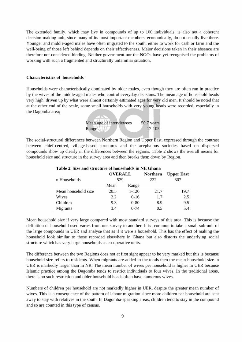
The extended family, which may live in compounds of up to 100 individuals, is also not a coherent decision-making unit, since many of its most important members, economically, do not usually live there. Younger and middle-aged males have often migrated to the south, either to work for cash or farm and the well-being of those left behind depends on their effectiveness. Major decisions taken in their absence are therefore not considered binding. Neither government nor the NGOs have yet recognised the problems of working with such a fragmented and structurally unfamiliar situation. Characteristics of households Households were characteristically dominated by older males, even though they are often run in practice by the wives of the middle-aged males who control everyday decisions. The mean age of household heads very high, driven up by what were almost certainly estimated ages for very old men. It should be noted that at the other end of the scale, some small households with very young heads were recorded, especially in the Dagomba area;
Mean age of interviewees 50.7 yearsRange 17-105
The social-structural differences between Northern Region and Upper East, expressed through the contrast between chief-centred, village-based structures and the acephalous societies based on dispersed compounds show up clearly in the differences between the regions. Table 2 shows the overall means for household size and structure in the survey area and then breaks them down by Region.
Table 2. Size and structure of households in NE Ghana OVERALL Northern Upper East
n Households 529 222 307 Mean Range Mean household size 20.5 1-120 21.7 19.7 Wives 2.2 0-16 1.7 2.5 Children 9.3 0-80 8.9 9.5 Migrants 3.4 0-74 0.5 5.4
Mean household size if very large compared with most standard surveys of this area. This is because the definition of household used varies from one survey to another. It is common to take a small sub-unit of the large compounds in UER and analyse that as if it were a household. This has the effect of making the household look similar to those recorded elsewhere in Ghana but also distorts the underlying social structure which has very large households as co-operative units. The difference between the two Regions does not at first sight appear to be very marked but this is because household size refers to residents. When migrants are added to the totals then the mean household size in UER is markedly larger than in NR. The mean number of wives per household is higher in UER because Islamic practice among the Dagomba tends to restrict individuals to four wives. In the traditional areas, there is no such restriction and older household heads often have numerous wives. Numbers of children per household are not markedly higher in UER, despite the greater mean number of wives. This is a consequence of the pattern of labour migration since more children per household are sent away to stay with relatives in the south. In Dagomba-speaking areas, children tend to stay in the compound and so are counted in this type of census.

10
Migrant labour patterns confirm anecdotal statements contained in the literature (§4.6); the UER is the major exporter of labour to the south. Dagomba households are almost all in regions of low population density and there is no necessity to send members south to earn cash to feed the residual household. 4.3 Religion The role of religion in the constitution of the Mossi-Dagomba states has been remarked in the previous section. Essentially, three religions compete in north-eastern Ghana, Islam, Christianity and traditional religion. Of these, traditional religion remains numerically the most important. Table 3 and Figure 2 show the religious affiliation of household heads recorded in the survey;
Table 3. Religious affiliation of respondents Religion Name Number % Christian 62 12 Muslim 197 37 Traditional, pagan 270 51
Islam predominates in NR, especially among the Dagomba, and was important in some parts of Mamprusi. In many cases, there is no perceived contradiction between claimed adherence to a world religion and the maintenance of traditional shrines. Thus a chief in the Bawku region can keep a mosque, a shrine and a piggery in close proximity outside his palace. Non-Muslim rulers, such as the chief of the Mamprusi, will call upon Muslims to participate in major rituals without perceiving this to be an affirmation of Islam. Most Dagomba in Tamale consider themselves to be Muslim and there has been substantial mosque-building in recent years, often with funds from Saudi Arabia. Traditional religion has been described by a number of authors and varies from one group to another. The core organisational element is the tendaana, or earth-priest, who is the guardian of the shrines that protect the well-being of the community and re-affirm the solidarity of lineages. Sacrifice is a key element of traditional religion and provides an important motive for the raising of domestic animals. Sacrifices take place throughout the year in annual cycle of rituals intended to promote agriculture and the harmony of the local group. In addition, funerals play a very significant role in the moral economy of the region. Every dry season there are sequences of funerals, or memorial ceremonies, for important people which draw large numbers of people. Such ceremonies require the sacrifice of livestock, especially cattle. Great prestige attaches the numbers and quality of animals sacrificed which provides a powerful motive for rearing them.
Figure 2. Religious affiliation of respondents Christian
12%
Muslim37%
Traditional, pagan51%
n=529
11
4.4 Land tenure The land tenure systems of Northern Ghana have been described by numerous authors (Pogucki 1950; Ollenu 1962; Der 1975; Bening 1976; Benneh 1976; Cheshire 1977; Abdulai 1986; Rufai 1987). There is also an extensive legal literature summarised in Abdulai (1986) but since this generally has a very limited impact on the ground it is not explored further here. There are two elements in understanding tenure systems in this region;
a) the division between farm and bush b) the independence of trees from the land on which they grow
Until this century the principal method of farming was shifting cultivation; villages moved within a demarcated zone, clearing the woodland, farming for some years and moving on. Allocation of lands in bush farms was through the earth priests, tendaana, but the abundance of land was such that competition for land was almost absent. Trees in the bush and preserved on farms were the property of the chief or earth-priest and could only be harvested or cut with their permission. Farms were divided by classes according to their productivity. Home farms and those in valleys or along rivers farms were the most valuable and could be cultivated continuously, while the bush farm was cultivated with a bush fallow system. Such land is held by the village/lineage and cannot be alienated (Benneh 1973a). Ownership of economic trees on farms has devolved to the individual who develops the land but the ownership of economic trees in the bush has now become a matter of dispute in some areas. In the Dagomba area, the chief and his assistants still try to enforce controls on the exploitation of these trees, but elsewhere, especially in UER, these have effectively collapsed. The first individual to reach a tree can harvest its fruit. These land tenure systems have been generally maintained up to the present. Although land is bought and sold around larger urban settlements, such as Bolgatanga, intense pressure on land in rural areas has not led to a monetarisation and individualisation of land rights as has been reported elsewhere in West Africa. Instead it has resulted in a consolidation of lineage holdings and a sharpening of boundaries. This unusual situation seems to reflect the continuing importance of traditional religion and the maintenance of lineage solidarity combined with the realisation that an individualisation of landholdings will rapidly lead to social and economic stratification. A consequence has been that the principle, that a developer of the land develops tenure rights, does not operate in the high-density areas. Land can be loaned to ‘strangers’ with the assent of the earth-priest, but even long residence does not usually mean the permanent acquisition of land rights. As a result, it is near impossible to accumulate large, consolidated landholdings, except in the lower-density areas near Tamale. Large-scale mechanised farming can be fairly said to have had no impact in this region. There have been occasional experimental farms, attached to research stations but they have had no impact on the region as a whole. The one exception to this is the production of rice in low-lying areas associated with the White Volta (Goody 1980; Shepherd 1981; Konings 1981). The principal road to the North runs through many of these areas, which was probably in crucial in inducing farmers to make investment decisions. The process seems have begun in the late 1960s with the new availability of HYVs and sufficient capital to buy both tractors and combine harvesters. Government made available agricultural credit and the opening up of large (100-300 acres) farms became commonplace. Clearly, the acquisition of such large holdings ran contrary to traditional land tenure procedures where farmers have rights in land worked in the immediate environs of the village. To obtain the written registration of landholdings necessary to guarantee bank

12
loans, complex political manoeuvring was required. This tended to skew the balance strongly in favour of the literate members of the community. This in turn created considerable resentment, with the consequence that resentments were worked out by burning the rice farms, a common phenomenon in the 1970s and 1980s (Goody 1980). The long-term consequence has been to deter potential large-scale capitalist investors. the low-lying areas have now been redivided among lineage groups in considerably smaller plots, tenure of which is managed along more traditional lines. Mechanisation is less important, although some farmers still hire tractors. It seems likely that any similar attempt to develop large-scale mechanised farming would be subject to similar problems. 4.5 Distribution of population Between the high density zones in Upper East Region (UER) and the lower-density areas in Northern Region (NR) is a marked contrast in the distribution of population. This pattern has been commented upon since the 1930s (Muri and Williams 1930; Fortes 1943; Hilton 1960b, 1968; Hunter 1965, 1967a, 1967b; Dickson 1971; Panin 1986). Hilton (1960b) plotted successive census figures on a series of maps and they show not only the striking density in UER but that its rate of growth is faster than other regions. Webber (1996a) measuring changes in a single village, Zaari, 1979-1993, found that the population had increased 18% with a corresponding rise in the number of farm households and fall in mean farm size. The detailed survey was intended to reflect this broad contrast but it should be emphasised that there are population hotspots in other regions of the NR. The Tolon area, west of Tamale, studied by Norton (1987) seems to have many features similar to those in UER. The area round Chereponi on the Togolese border south of Nyakpanduri is well-known for the absence of vegetation cover (Kirby 1987). Similarly, the extreme west of UER, beyond Sandema has low population densities more characteristic of UWR. The reasons for this uneven pattern have been the source of much reflection but no very convincing hypothesis has been advanced to explain it. No simple climatic or soil model is relevant, since much of Upper West is part of the same physiographic system and it has some of the lowest population densities in Ghana. The roots may therefore be sociological and relate to the powerful hold the lineage system still has over individuals. Throughout much of Africa, a typical response to severe deterioration in agricultural production is for whole subsections of the community to split off and form a new settlement in a lower-density zone. Such settlements gradually break their economic and ritual links with the base community and become an independent unit. This does not occur in UER, where households retain an intense relationship with their original territory. Although subsistence means that the household usually has to be split, the personnel involved in this are quite fluid. The death of an elder means that those in the south may be recalled to take over their position managing the ritual cycle. Anecdotal evidence suggests that few who are called in this way refuse to return. The consequence is that populations continue to rise. There appear also to be specific historical reasons for the compacting of population beyond a simplistic environmental determinism. Hilton (1959) points out that the extensive slaving throughout this region during the nineteenth century led to re-invasion of large mammals and a consequence re-infestation by tsetse making regions uninhabitable because of sleeping sickness.

13
This pattern was historically a source of concern to agriculture and forest officers. Vigne (1935) observed;
The very densely inhabited areas of the Bawku, Zuarungu, Navrongo districts point to a warning as the result of uncontrolled development. The population of the northern Territories is increasing very rapidly and steps should be taken to prevent a repetition of this wholesale deforestation.
4.6 Labour migration and its consequences The relative wealth of the forest zone in terms of gold-mining, timber and cocoa have created an important magnet for surplus labour in the savannas ever since the 1920s onwards when cheap transport made possible seasonal migration (Davison 1954; Hilton 1961; Hunter 1965; Caldwell 1969). A pattern developed of young males travelling south towards the goldfields and cocoa plantations of the south of Ghana. The usual strategy was to return for the wet season and assist with farmwork. Cash wages were attractive as they allowed unmarried men to accumulate capital to buy cattle essential for marriage and, later in the life-cycle, for sacrifice at funerals. Indeed the wealth of southern Ghana was such that labourers also migrated from neighbouring Francophone countries, a drawing off of resources that accounts for the rather aggrieved tone of some of the literature (Dresch 1945; Rouch 1956; Le Moal 1960). Another aspect of migration, however, was that it took pressure off food and other resources in areas where the human population density was high. There were less mouths to feed in the hungry season and the migrants sent back cash which could be used to buy food. As pressure on the land has increased this element has become of major structural importance in household strategies. Webber (1996a) comparing a Kusase community in UER between 1979-1993 found that the marked absence of males in the 20-55 age range had hardly changed over this period. In contrast to patrilineal systems elsewhere it is the eldest sons who are sent away and the youngest son was maintained in the household to stand in for the father. Initially a seasonal migration, this movement of Northerners to the south took on increasing aspects of permanence. Northerners found posts in the civil service, began to run businesses and to marry and establish households in the south. This created an important support network for ‘new’ southerners coming to the south from any given ethnic group (Hart 1969, 1971a, 1971b). The consequence was that in reality, split households were established with a constant flow of individuals between the two. However, the notion that sons returned to work on the farm in the rainy season was strongly maintained for sentimental reasons even though it is manifestly false. Even today it is frequently presented to outsiders and is widely believed by non-northerners. Another important aspect of the myths around northern migrants is that since the object was to accumulate cash, there was no involvement with farming. Indeed it was said that land could not be obtained in areas further south due to hostility of local populations. This too is no longer true and the Kusase have established whole communities in Brong-Ahafo producing surplus food which they send home to their families in the Bawku area as a version of food aid. It is striking, however, that they do not simply split the community and form a new independent economic unit in another location. They still regard themselves as part of the lineage located in the Kusase homeland. The overt reason given for this is that this is where ancestral shrines are located and that these cannot be transplanted. 4.7 Human population: nutrition and disease The low investment in agricultural labour and hence in soil and water conservation also reflects the poor state of health of many individuals in this region. The low output from the farming system is responsible

14
for marked seasonal hunger, low bodyweights and systematic malnutrition of all sections of the population (Hunter 1967c; Tripp 1978, 1981, 1992; Benneh 1985). This makes the populations particularly susceptible to the epidemics of cerebro-spinal meningitis that sweep through the region every dry season, often with considerable mortality. 5. Agricultural systems 5.1 Existing research on agriculture The tradition of agricultural research in Northern Ghana goes back to the colonial agricultural service in whose annual reports are found many useful descriptive materials on both cropping and woodland management. The monograph-length description by Lynn (1937) of agriculture in North Mamprusi remains a standard reference, but important additional material can be found in reports of other years (Coull 1929; Cowan 1930; Hill 1930; Muir and Williams 1930; Lynn 1942, 1946) Apart from these, some officers found it useful to publish in ‘Farm and Forest’ a journal printed in Nigeria which was intended to pool experiences of agriculture in West Africa (e.g. Lynn 1946; Morris 1946). University research began in the 1950s, but took off in earnest after Independence, when many more Ghanaian researchers began publishing. A valuable summary of agricultural research up this time is Wills’ (1962) ‘Agriculture and land use in Ghana’. The location of these institutions in the high forest zone tended to preferentially disadvantage the savanna regions, but this was partly remedied by the establishment of Nyankpala Research Station (now SARI, the Savanna Agricultural Research Institute). Originally funded by GTZ, it has now been entirely handed over to the Ghanaian government. Its brief has been to research savanna agriculture, and the concentration has been on crops, rather than livestock or woodland. However, recently, the Government of Ghana has recognised the importance of agricultural research in a University context and a University of Development Studies has been established at Tamale. The consequence of this is that there is a substantial body of research on the savanna farming systems in the Tamale area, especially around the research station itself, which is in a rather uncharacteristically high density farming area. There is a considerable amount of unpublished research material inventoried at Nyankpala, usually summarised in the annual reports. In addition there are proceedings and monographs including (Diehl & Runge-Metzger 1985; Hailu & Runge-Metzger 1993; Donhauser, Baur and Langyintuo 1994). Research in UER has been more patchy, since it has been largely conducted through the work of individual researchers. Tripp (1978, 1981, 1992) describes the agricultural systems in the Navrongo area and Benneh (1972, 1973a, 1973c) describes aspects of agriculture for Sissala villages west of Navrongo. For the Bawku area, Chilalah (1957) and Collins (1960) describe the agricultural extension work undertaken in the colonial era, Cleveland (1980) discusses household composition an demography in relation to agricultural systems and Webber (1990, 1996a, 1996b) gives a valuable account of agricultural change between 1979 and 1993.
Section
55

15
5.2 Systems of cultivation 5.2.1 Rainfed Variable population densities are reflected in the cultivation systems distributed across the region. Until recently, shifting cultivation seems to have been dominant in much of the low-density area east of Tamale. It is still quite common in parts of Upper West. More recently, bush-fallow systems have become predominant as owners invest in construction and transport infrastructure requires that villages be sited along roads. Strikingly, however, some areas of UER have shifted to permanent cultivation. Permanent rainfed cultivation is extremely rare in Africa as a whole although it has been described around large cities in Northern Nigeria (e.g. Mortimore 1988). In Nigeria, these systems are based around large-scale transportation of urban waste to fertilise the fields; in other words they depend on the proximity of densely settled non-farming populations. In UER, the regions of permanent cultivation are not close to large towns but are associated with remote rural areas and ‘compound farming’. The farming system in UER is based around dwarf millets, cucurbits and pulses which would normally be encountered in lower rainfall zones elsewhere (Coull 1929). Cultigen diversity is low, probably a response to poor soil fertility. Animal traction is extensively used, but not to throw up ridges that could improve rooting and counteract erosion (Lynn 1937; Panin 1986). Further south, yams become more dominant in the system, which reflects both the value of mounding in counteracting subsoil hardpan, but also the large southern market. Yams reflect important cultural values through much of the south but in reality most farming populations have been forced to switch to cassava due to lowered soil fertility. 5.2.2 Irrigated Early records of agriculture suggest that all types of irrigation or flood-retreat agriculture were virtually unknown in the pre-colonial era. These labour-intensive production systems were probably inappropriate for populations which depended heavily on gathered produce and rainfed swidden agriculture. A factor that may have acted as a discouragement is the presence of river-blindness (onchocerciasis) along all the major water-courses. This has caused populations to retreat from the most fertile areas and subsequently to return to them once a health equilibrium has been established (Hunter 1966; Patterson 1978). However, the pressure on land and the need to produce cash crops for sale has gradually brought about innovative farming techniques. It seems quite likely that Muslim migrants such as the Zarma and the Hausa were the first to practise horticulture in riparian areas. Many of the larger rivers are still not exploited in this way for lack of adequate methods of lifting water4. However, most shallow rivers and seasonally flooded land is now given over to dry-season gardening, especially in UER. In addition, where ‘dugouts’ (small dams for trapping water for both humans and livestock in the dry season) have been excavated, gardens are sometimes established on their edges. Onion cultivation is particularly popular and probably represents one of the most important agricultural exports form the region. Along the River Tongo, west of Navrongo, a series of small dams has allowed most of the river banks to be developed for flood retreat gardens. The large-scale rice farms that were established in the 1970s are discussed above (§4.4). Most of these have now been broken into much smaller-scale operations. 4 In other neighbouring countries, such as Nigeria, small petrol pumps were introduced by Agricultural Development Projects to lift water to gardens and these are still widely used despite being no longer subsidised. It may be that the technology has so far failed to transfer to this region or that the transport infrastructure to bring horticultural products to market is too weak for their use to be economic.

16
The spread of flood-retreat cultivation in the decades since 1960 is one of the factors of agricultural change that contradicts the rather gloomy prognostications given in the opening quotes. Its impact is, however, patchy, depending on the proximity of appropriate terrain and a market infrastructure adequate to export surplus products. It undoubtedly has the additional benefit of improving the diet of the producers and providing work for adult males who might otherwise be forced to migrate. There is still an opportunity to develop some of the larger rivers for irrigation, given appropriate water-lifting technology. 5.3 Crops 5.3.1 Crop Species and Varieties Compared with similar areas of West Africa, for example, Central Nigeria, the cultigen repertoire in this part of Ghana is restricted. In addition, the spectrum of cultivated varieties is similarly reduced. Appendix Table 1 lists the crops grown in north-eastern Ghana together with local names where different. Cereals The basis of the cropping system throughout UER is pearl millet. There are two groups of millet cultivars, a short-season millet harvested in July and a long-season millet, harvested in November or December. The dominance of millet in such a high rainfall area is striking as millet is usually associated with subdesertic regions. The early millet is interplanted either with late millet or sorghum in fields close to the compound where fertility is highest. The further fields are planted with sorghum intercropped with pulses, especially cowpeas and occasionally groundnuts. The millets of Northern Ghana have been described in more detail in Appa Rao et al. (1985) and it is worth noting that they display many unusual characteristics in terms of West Africa as a whole. These differences are so considerable as to convince early taxonomists to classify these millets a separate species, although they are regarded today as race globosum. Maize underwent a burst of popularity during the period when fertilisers were available at subsidised rates. However, hardly any farmers reported planting it in 1997 since no fertilisers were available and soil fertility, if anything, has declined still further. Rice (Oryza sativa not African rice) is planted in swampy lowlands and there are small pockets of fonio along the Togolese border. Tubers Although often characterised as a quintessentially humid-zone crop, the Guinea yam is of major importance throughout much of NR. The Dagomba recognise more than thirty different cultivars and the Vagla, who live in the far west of NR a similar number. Cassava, cocoyams and sweet potatoes are cultivated in small plots, usually in riverine areas. The ‘Frafra potato’ (Plectranthus esculentus) was formerly extremely common in the Bolgatanga area, but now has bee displaced by Irish potatoes. 5.3.2 Change in the cultigen repertoire Two marked changes have occurred in the cultigen repertoire in recent times; the spread of ‘European’ vegetables with the gradual disappearance of some minor indigenous crops and the increased interest in planting fruit trees. Carrots, cabbage, lettuce, peas and brinjals are all now readily available in larger market towns. They are grown in irrigated plots close to towns and were probably originally planted for

17
expatriates. However, they have now infiltrated local diets to quite a significant level. The disappearance of the Frafra potato is mentioned above and there is some evidence that some of the local mucilaginous green leaves are also in decline. The planting of fruit trees, especially citrus, cashew and guava is now becoming widespread. Seedlings are available from a wide variety of sources, especially NGOs and church organisations. There has been a development of commercial nurseries and some farmers are simply buying seedlings on the open market. 5.4 Trees in farms and trees in the bush Farmers in all areas of Ghana leave economic trees in their farms. Such trees are usually referred to as ‘subspontaneous’ or ‘protected’. The most important of these trees are shown in Table 4;
Table 4. Economic trees left on farms Locust = dawadawa Parkia biglobosa I Shea Vitellaria paradoxa I Kapok Ceiba pentandra I Baobab Adansonia digitata I Whitethorn Faidherbia albida I Tamarind Tamarindus indica I Black plum Vitex doniana I Monkey guava Diospyros mespiliformis I Mango Mangifera indica E Teak Tectona grandis E Neem Azadirachta indica E I = indigenous E=exotic
Other species recorded were Lannea microcarpa, Terminalia reticulata, Pseudocedrela kotschyi and Mitragyna inermis. The usual convention is that the owner of the land has rights over the produce of these trees unless he has otherwise ceded this right. Norton (1987) notes that in a few areas, major trees, such as dawadawa, belong not to the farmer but to the chief who has the right to harvest them and give a portion to the farmer. Leaving trees in farms has advantages and disadvantages. Farms with trees in the field are unsuitable for tractor cultivation. Although oxen can be guided around a limited number of trees, animal traction becomes problematic is there are too many and the likelihood of residual stumps to break the share. The mango takes up considerable subsoil water and farmers have observed that water-tables fall when there are too many in the farm. Where land is short, the poor crop yields of plants shaded by the tree are perceived to be a disadvantage. On the other hand, trees provide shade, fruit, prevent erosion and return fertility to the soil. In the low-density areas around Tamale, the trees left in the farm are visibly more numerous and also farmers cite a great many more species. In the high-density region around Bawku often only three species are retained and the remainder grubbed out. This makes income from tree products vulnerable to market fluctuations and threatens trees whose products are falling in value. The consequence of this loss of diversity is the open landscape. Farmers in UER were much more likely to ask for subsidised tractors than those further south, a pattern contrary to other parts of Africa.

18
Changing importance of subspontaneous tree species In the precolonial era, the hierarchy of subspontaneous tree species was probably locust, shea and kapok. The fruits of all were considered to be of great value and their collection and processing the subject of some competition. However, the penetration of the global economy has changed the values attributed to these trees. The locust, which produces primarily a seed made into a fermented cake for food-flavouring remains popular, but the cakes must now compete in the marketplace with industrial flavourings and stock cubes. Moreover, the locust has no export value. The kapok, which produces a lint for stuffing pillows and cushions and whose seed is sometimes used as a soup ingredient, is so numerous that many of its fruits lie on the ground unused. Industrial foams and other products have made the lint of almost no market value. By contrast, the value of shea-butter is constantly increasing as it is now exported and commands a steadily rising price. In Nigeria, in a similar ecozone, the shea has been displaced as an oil-plant by groundnuts and processing has halted completely as the trees have been grubbed out. 5.5 Soil and water conservation A major contrast between the farming systems in the Tamale area as opposed to UER is the importance of yams. The Dagomba are major cultivators of yams and raise large mounds across the region. In the cereal-based agriculture further north, ridges are intended to prevent soil erosion and mineral leaching. The ridges are, however, poorly constructed, without ties and are visibly of limited effectiveness. Much of the region is extremely flat but on the occasional hilly areas, terracing is sometimes practised. There are small stone terraces on some of the sloping terrain on the Bolgatanga-Bawku road. The grubbing-out of trees in much of UER has been responsible for considerable soil erosion throughout the zone. The system of along animals to graze freely on the sparse vegetation returns some nutrients to the soil through their manure. But the absence of grass cover and patches of uncultivated land reduces the potential for recycling organic matter. 5.6 Farm inputs The use of farm inputs has been strongly driven by the passing enthusiasms of agricultural development projects. Manure was traditionally used, especially in the UER, to increase the fertility of the fields and is still collected and redistributed throughout much of the region. The first inorganic fertilisers were introduced into the region by the colonial government in the 1950s and gradually became a substitute for maintaining soil fertility by traditional means. Through much of the post-Independence era, fertiliser was heavily subsidised. However, the subsidies were progressively eliminated after 1983, with the consequence that they became too expensive for many farmers. Farmers who work with the cotton companies still receive fertiliser at below market prices. Use of pesticides is much less common and is often confined again to chemical used on cotton or for cowpeas. Herbicides are hardly known and indeed often not readily available. Table 5 and Figure 3 show the percentages of farmers using different input types.

19
Table 5. Percentage of farmers using different inputs n=529
Yes or No Fertiliser % Manure % Pesticides % Herbicides %No 153 28.9 114 21.6 330 62.4 505 95.5Yes 376 71.1 415 78.4 199 37.6 24 4.5
Figure 3. Percentage farmers using differemt input types
0.0 10.0 20.0 30.0 40.0 50.0 60.0 70.0 80.0
Percentage Farmers using
Fertilis
er?
Manure
Pestici
des
Herbici
des
Inpu
t typ
e
n = 529
Farmers regularly emphasised that increasing prices in the last few years had both decreased the numbers of farmers using inputs and the quantities used. 5.7 Tillage Animal Traction Animal traction was introduced into this region in the 1930s to increase production of cash crops, especially cotton. The main implement used is a heavy ridger pulled by paired oxen. Carting has never been at all common, although there are occasional ox-carts made from the chassis of wrecked cars. Studies of the role of animal traction in the farming system are reported in Panin (1986), Hesse (in press) and Webber (1996a).
20
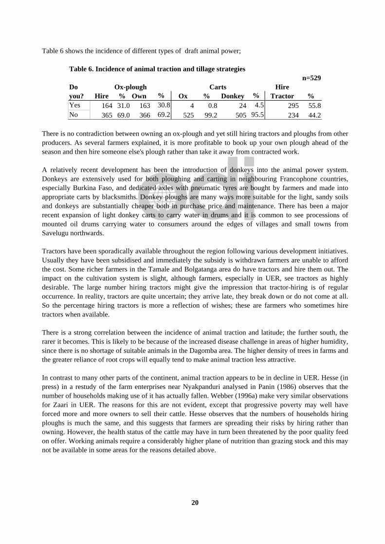
Table 6 shows the incidence of different types of draft animal power;
Table 6. Incidence of animal traction and tillage strategies n=529
Do Ox-plough Carts Hire you? Hire % Own % Ox % Donkey % Tractor % Yes 164 31.0 163 30.8 4 0.8 24 4.5 295 55.8No 365 69.0 366 69.2 525 99.2 505 95.5 234 44.2
There is no contradiction between owning an ox-plough and yet still hiring tractors and ploughs from other producers. As several farmers explained, it is more profitable to book up your own plough ahead of the season and then hire someone else's plough rather than take it away from contracted work. A relatively recent development has been the introduction of donkeys into the animal power system. Donkeys are extensively used for both ploughing and carting in neighbouring Francophone countries, especially Burkina Faso, and dedicated axles with pneumatic tyres are bought by farmers and made into appropriate carts by blacksmiths. Donkey ploughs are many ways more suitable for the light, sandy soils and donkeys are substantially cheaper both in purchase price and maintenance. There has been a major recent expansion of light donkey carts to carry water in drums and it is common to see processions of mounted oil drums carrying water to consumers around the edges of villages and small towns from Savelugu northwards. Tractors have been sporadically available throughout the region following various development initiatives. Usually they have been subsidised and immediately the subsidy is withdrawn farmers are unable to afford the cost. Some richer farmers in the Tamale and Bolgatanga area do have tractors and hire them out. The impact on the cultivation system is slight, although farmers, especially in UER, see tractors as highly desirable. The large number hiring tractors might give the impression that tractor-hiring is of regular occurrence. In reality, tractors are quite uncertain; they arrive late, they break down or do not come at all. So the percentage hiring tractors is more a reflection of wishes; these are farmers who sometimes hire tractors when available. There is a strong correlation between the incidence of animal traction and latitude; the further south, the rarer it becomes. This is likely to be because of the increased disease challenge in areas of higher humidity, since there is no shortage of suitable animals in the Dagomba area. The higher density of trees in farms and the greater reliance of root crops will equally tend to make animal traction less attractive. In contrast to many other parts of the continent, animal traction appears to be in decline in UER. Hesse (in press) in a restudy of the farm enterprises near Nyakpanduri analysed in Panin (1986) observes that the number of households making use of it has actually fallen. Webber (1996a) make very similar observations for Zaari in UER. The reasons for this are not evident, except that progressive poverty may well have forced more and more owners to sell their cattle. Hesse observes that the numbers of households hiring ploughs is much the same, and this suggests that farmers are spreading their risks by hiring rather than owning. However, the health status of the cattle may have in turn been threatened by the poor quality feed on offer. Working animals require a considerably higher plane of nutrition than grazing stock and this may not be available in some areas for the reasons detailed above.
21
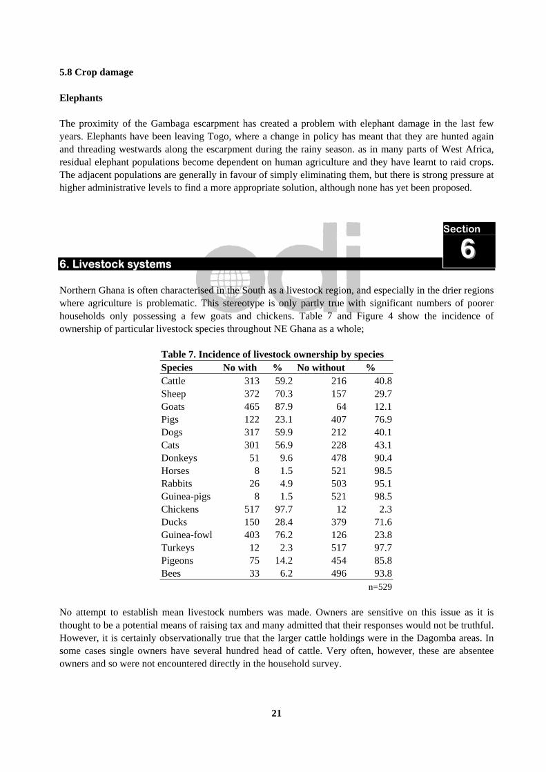
5.8 Crop damage Elephants The proximity of the Gambaga escarpment has created a problem with elephant damage in the last few years. Elephants have been leaving Togo, where a change in policy has meant that they are hunted again and threading westwards along the escarpment during the rainy season. as in many parts of West Africa, residual elephant populations become dependent on human agriculture and they have learnt to raid crops. The adjacent populations are generally in favour of simply eliminating them, but there is strong pressure at higher administrative levels to find a more appropriate solution, although none has yet been proposed. 6. Livestock systems Northern Ghana is often characterised in the South as a livestock region, and especially in the drier regions where agriculture is problematic. This stereotype is only partly true with significant numbers of poorer households only possessing a few goats and chickens. Table 7 and Figure 4 show the incidence of ownership of particular livestock species throughout NE Ghana as a whole;
Table 7. Incidence of livestock ownership by species Species No with % No without % Cattle 313 59.2 216 40.8 Sheep 372 70.3 157 29.7 Goats 465 87.9 64 12.1 Pigs 122 23.1 407 76.9 Dogs 317 59.9 212 40.1 Cats 301 56.9 228 43.1 Donkeys 51 9.6 478 90.4 Horses 8 1.5 521 98.5 Rabbits 26 4.9 503 95.1 Guinea-pigs 8 1.5 521 98.5 Chickens 517 97.7 12 2.3 Ducks 150 28.4 379 71.6 Guinea-fowl 403 76.2 126 23.8 Turkeys 12 2.3 517 97.7 Pigeons 75 14.2 454 85.8 Bees 33 6.2 496 93.8 n=529
No attempt to establish mean livestock numbers was made. Owners are sensitive on this issue as it is thought to be a potential means of raising tax and many admitted that their responses would not be truthful. However, it is certainly observationally true that the larger cattle holdings were in the Dagomba areas. In some cases single owners have several hundred head of cattle. Very often, however, these are absentee owners and so were not encountered directly in the household survey.
Section
66

22
Figure 4. Pattern of Livestock ownership in NE Ghana
0.0 10.0 20.0 30.0 40.0 50.0 60.0 70.0 80.0 90.0 100.0
Cattle
Sheep
Goats
Pigs
Dogs
Cats
Donkeys
Horses
Rabbits
Guinea-pigs
Chickens
Ducks
Guinea-fowl
Turkeys
Pigeons
Bees
Spec
ies
Percentage Ownership
n=529
NE Ghana January-March, 1997
In the case of the major economic species, there are marked regional differences in the incidence of species kept. Table 8 and Figure 5 show the differential incidence of livestock ownership in NR and UER. The Islamic ideology of many Dagomba militates against pig production, even among those who are no Muslims. By contrast, pigs are very common among the acephalous peoples of UER.
Table 8. Regional inequalities in incidence of livestock ownership Region n Cattle % Sheep % Goats % Pigs % Northern 222 94 42.3 138 62.2 181 81.5 1 0.5Upper East 307 219 71.3 234 76.2 284 92.5 121 39.4
The incidence of cattle-keeping is interesting as the Dagomba stereotype themselves as cattle-owners. However, social inequality is much greater and cattle are confined to the wealthier stratum of society. In UER, most people have some cattle, especially for animal traction. The same is true of small ruminant ownership to a certain extent; almost every household has some sheep or goats.

23
Figure 5. Regional differences in livestock ownership
0.0
10.0
20.0
30.0
40.0
50.0
60.0
70.0
80.0
90.0
100.0Pe
rcen
tage
Cattle Sheep Goats Pigs
Species
Northern
Upper East
n Northern = 222n Upper East = 302
NE Ghana January-March 1997
In the case of minor species, such as rabbits, guinea-pigs and poultry other than chickens these are spread fairly evenly throughout the area and their distribution reflects individual enthusiasm rather than sociocultural differentiation. Cattle Unusually for West Africa, the principal breed herded in Northern Ghana is the West African Shorthorn (WAS) albeit with substantial introgression of zebu genes in some places. These cattle are very hardy and well adapted to a difficult environment. Work-oxen represent a relatively recent innovation, but prior to that all cattle were are allowed to roam freely in the dry season (as also goats, sheep and pigs). In the wet season, small ruminants and pigs were tethered or confined. Wet season management of the herds was left to children, often with deleterious effects. More recently it has become common to employ cattleless Ful∫e as herders. Local pastoral herds have acted to all but exclude Fulani zebu herds from Burkina Faso seeking pasture in the dry season. Such herds have recently been entering Ghana along the Togolese border and leading to conflicts with farmers. The usual bases for exchange between pastoralists and farmers (milk/cereals and stover/manure) do not function in Ghana because of the indigenous pastoral culture. The marketing of livestock has historically been a subject of considerable controversy. Historically, Northern Ghanaian peoples have been regularly accused of withholding stock from the market and being uninterested in the improvement of livestock for sale (see, for example Wills 1962:219). Hill (1970) in an influential study of the Northern cattle trade in 1964-5, based largely on statistics of cattle reaching Kumasi argued that this was Southern stereotyping and that in fact Northern cattle owners were only too

24
willing to sell cattle, especially immature males. The subtext here was that African farmers were shrewd, entrepreneurial rural capitalists, and that old-fashioned anthropologists who were quite wrongly insisting on the cultural role of cattle in northern societies and who thereby perpetrated this misleading stereotype. To be fair, Hill (1970:82) does make a possible exception for the Northeast as ‘different’. This is fortunate, as ethnographically, as her model seems to be entirely false. Throughout the parts of UER included in the survey, there was no evidence at all, that owners ever considered the market at all in cattle production. Cattle are produced principally for marriage payments and sacrifices at funerals. This is not because farmers are not market-oriented in certain spheres, even including livestock, because there is good evidence that the notion of investing in pigs to improve their sale price is currently spreading. Pigs play little or no role in major ritual activities and indeed can be kept by women and are thus highly suitable for income generation. The role of cattle in sacrifice, however, completely excludes them form this sphere of activity. This is confirmed by concrete production characteristics of the cattle (Hall ined.). Other livestock species The other livestock species kept in northeastern Ghana include horse, donkeys, goats, sheep, pigs and poultry of various types. There are virtually no intensive production systems in the region and small stock are allowed to forage freely in the dry season and confined in the wet. Apiculture Wild bees are common in the low-density areas and it is common to gather honey by smoking out the bees. Swarms of wild bees feature in many oral traditions and they are frequently conceived as protectors of sacred places, as well as coming to assist one or other group in warfare. In some places, there is rather limited apiculture, usually based around either a hollow log or a pot placed in a tree. In one of these is a removable tray used, so the honey producer is obliged to drive off the bees and seek a new swarm the following year. This has encouraged development agencies to try and introduce modern types of hive. There was a GTZ-funded project in the area south of Tamale in the 1980s and some owners till persist with these hives although they have failed to spread. In Bolgatanga, a similar project has been more successful, in part because there is a flourishing beekeeping supply shop which supplies materials for making and repairing hives. Honey is sold locally in the markets, but there is no inter-regional trade. 7. Exploitation of bush resources 7.1 Plant products The principal plant products that are collected for use and sale are the fruits of trees. The principal species of economic tree are;
Section
77

25
Table 9. Principal species of economic tree Name Scientific name Part used Locust = dawadawa Parkia biglobosa Seed, powder, pod Shea Vitellaria paradoxa Fruit eaten, kernel processed for oil Kapok Ceiba pentandra Lint sold for stuffing cushions etc. Baobab Adansonia digitata Seeds sold for flavouring Tamarind Tamarindus indica Pod sold for flavouring Black plum Vitex doniana Fruit sold for eating Lannea microcarpa Fruit sold for eating Monkey guava Diospyros mespiliformis Fruit sold for eating Mango5 Mangifera indica Fruit sold for eating
7.2 Hunting Until recently, hunters constituted and important subgroup in society and contributed significantly to the diet of villagers. The disappearance of much of the remote woodland throughout UER and much of NR has meant that hunters have hardly anything to hunt. The response of some has been to 7.3 Fishing The Northeast is shot through with rivers, mostly branches of the Volta system. The Red, Black and White Volta run through the area and their potential for inland fisheries is very significant. Curiously, this is relatively underexploited compared with, for example, the intense fisheries that operate on the Niger river. There are no specialised fishing-peoples and even canoes and fish-fences are not common on the large rivers. This low-key attitude is reflected in government, whose fisheries departments are sparse and concerned principally with the transport and supply of frozen and chilled fish form the Volta or even the sea. Fishing appears to be a highly ritualised activity. Very often the community will take part on large-scale communal fishing of a specific resource at a particular time of year. Some of these ritual fish-hunts have been described by anthropologists (e.g. Fortes 1937; anon. 1947). Apart from the sacred groves described elsewhere, in many places it is common for the sacred sites to be stretches of river. In such places, fishing is forbidden and indeed the river may be annually desilted to ensure that it flows freely. 7.4 Gold-mining Although it has been known since the First World War that a gold reef cuts diagonally across northeastern Ghana, the costs of extraction compared with the yield and the highly effective southern Ghanaian mining culture left it unexploited until recently. In 1992, changes in the technology of gold-mining in the south led to redundancy among many experienced miners. This somehow initiated a rush to extract gold from the reef in the Nangodi area, east of Bolgatanga.
5 Mangoes are regarded locally as found in the bush, although they all derived from imported materials.

26
The first sites to be established were in forest reserves and small townships with electricity, shops and mercury extraction sites were rapidly established. These were entirely without the agreement of the forestry Department and in 1995 the miners were removed forcibly. They have now relocated to a region outside the reserve and the mines are functioning as before. The mines are up 50 m. deep and are without adequate safety precautions. The damaging effects of mines are that the surrounding vegetation is rapidly depleted for firewood and beer-brewing. Of greater long-term concern, however, is the pollution of the groundwater with mercury. From the point of view of the region, however, the miners are bringing substantial wealth into the area. Relatively few miners are from the indigenous populations, but nonetheless, they benefit from secondary employment as well as an expanded retail sector. However, to profit more directly, the Regional Assembly began to invite external companies into the area in 1996 and a number of these are established in Bolgatanga. The advantage of this is that they can make revenue payments directly to the Region significantly improving their cash-flow. In these circumstances, the possible environmental impact of mining is inevitably a low priority for administrators. 8. Pressure on the environment A major source of pressure on the environment is the need for cooking fuel. Traditionally, all cooking was done open fires with cookpots supported by three stones. Firewood was fathered in the woodland areas and, apart from restrictions on individual tree species was considered freely available. Although the great majority of households still gather fuelwood, in the high-density areas of UER, this has become a scarce commodity. The principal substitutes for fuelwood are cereal stems and dung. Table 10 and Figure 6 show the percentage of households exploiting different sources of fuel;
Table 10. Percentage of farmers using different types of fuel n = 529
Yes or No Firewood % Charcoal % Gas % Cereal stems % Dung % Do not use 14 2.6 184 34.8 514 97.2 131 24.8 219 41.4Use 515 97.4 345 65.2 15 2.8 398 75.2 310 58.6
The use of animal dung and cereal stems is concentrated in UER, due to the absence of accessible fuelwood. This has serious consequences for the renewal of soil fertility throughout the region.
Section
88
27
Figure 6. Percentage farmers using different types of fuel
0.0
10.0
20.0
30.0
40.0
50.0
60.0
70.0
80.0
90.0
100.0
Perc
enta
ge u
sing
Firewood Charcoal Gas Cereal stems Dung
Type of fuel
n = 529
The high percentage of farmers using charcoal is interesting because charcoal production is often condemned during discussions as the work of ruthless outsiders. Most villages on the road sell charcoal to passing traffic but households also appear to use it themselves in times of fuelwood shortage. 9. Developers at work If any group of people qualify for the title ‘the people without history’ it may well be developers. By and large development projects are conceived in an absence of information about previous initiatives. Whatever lessons such initiatives brought home to their designers and the funding agencies were not passed on either to government or to other bodies. In part, this reflects the extreme fragmentation of the development process, at least in this region. A multiplicity of agencies are inevitably more concerned about their own survival in a competitive market than whether they are duplicating the work of other agencies or repeating strategies that have failed elsewhere. 9.1 Government, Multilateral and bilateral aid agencies Northern Ghana has been the site of a series of major initiatives by international Agencies, starting with a FAO study in 1977, reprised by FAO/IFAD in 1989. Part of the IFAD project continues as the ‘Smallholder Rehabilitation’ Project, principally in the area of livestock improvement. In the early 1980s a ‘Northern Region Integrated Project’ was conceived to take an integrated approach to planning and agricultural development (anon. 1983). Although the NORRIP village outside Tamale is still functioning, the decline in operational funding has meant that virtually no work is in progress. The World Bank initiated a National Livestock Services Project (NLSP) in 1993 to improve veterinary care, to finance the construction of communal water holes and introduce the use of improved pastures. During the same period a Forestry Resource Management Project (FRMP) was undertaken, principally in the South. A second phase, the Forestry and Wildlife Resource Management Project (FWRMP) is intended
Section
99

28
to address savannah forestry issues more directly. Pre-appraisal missions have taken place and the project is presently being designed. 9.2 NGOs If gaily-painted signboards are held to constitute development, then Northern Ghana has no further need of it. The road to every village is festooned with a clutter of signs inscribed by both NGOs and UN agencies announcing the various development assistance initiatives taking place in the village. Within the villages numerous signs proclaim the projects under way. There seems to be virtually no control on what NGOs can operate in this region and none on the scope and nature of their projects. If their achievement in the field of sustainable development is sometimes opaque, there is no doubt about their importance in generating secondary employment. NGOs have been reviewed in Alebikiya (1993) and Amanor et al. (1993) although for obvious reasons these accounts are fairly anodyne. NGOs represented include the large well-funded international organisations such as OXFAM and Save the Children fund, as well a host of smaller operations. Church-based NGOs are important and all the major denominations have some type of operation. ADRA, the Adventist Development and Relief Association, is one the largest players, both in Northern Ghana and in adjacent Burkina Faso. In UER, Actionaid is one of the most important players with a major operation in Bawku with subsidiary stations elsewhere in the region. There has been no overall evaluation of the impact of NGOs on the regional economy and in particular food security. However, in general food security has not increased since food aid is now distributed every year almost independently of climatic variation. During the survey, farmers were asked about potential improvements to agriculture and a significant minority responded by suggesting increased food aid. This points to a disturbing aid-dependency mentality which is especially widespread in UER. ‘A shifting bundle of mirrors’ It is usual to learn that solutions to community problems are worked out with the participation of stakeholders in PRA-type exercises. Through a process of question and answer, it is relatively easy for NGOs to prompt farmers into identifying problems for which the solutions are available because they have ‘worked elsewhere’. Throughout much of the northeast of Ghana there is a very high density of NGOs pressing farmers to conform to their agendas. Farmers have become very astute at learning and replaying conventional NGO wisdom during the course of surveys. Farmers can reasonably expect that if they give the correct answers then perhaps the road will improve, a well will be dug or improved goats be handed out. This is troubling for researchers with no very fixed agenda, as the answers that surface in interviews are sometimes in startling contradiction to observed behaviour. The consequence is that the gap between what farmers say they will do and what they actually do has grown ever wider. 10. Policy implications Ghana will devolve increasing power to Regional and District Assemblies in the coming years. One element of this will place control over natural resources in the hands of these bodies. It is also intended that Government Departments change shape, and the Forestry Department, for example, to become a Forestry
Section
1100
29
Service. This will mean an effective end to the policing role they have maintained for a considerable period. Given the political pressure that will be exercised by farmers desperate for access to the remaining reserved areas, only a powerful land use planning exercise, implemented early in the new regime, is likely to preserve the balance of human population and natural resources. 10.1 Land use planning: genesis and evolution The particular problems of the granite areas of northern Ghana have been recognised since the 1930s and the notion that population and land use planning was the appropriate response go back at least to Lynn (1937, 1942). Lynn argued that a combination of; a) already high population densities b) fragmentation of holdings c) uncertain rainfall d) uncontrolled livestock movement e) low-yielding crop varieties f) lack of inputs g) lack of anti-erosion measures meant that economies of scale were not operative and that the unsustainability of agriculture could only increase. The end-process of his work was the North Mamprusi Forestry Conference of 1947, where a series of Forest Reserves were established in selected areas along the main watersheds. With additional funding and technical advice from the IDC, these were established as Land Planning Areas (LPAs) (Hilton 1959). Some success were recorded in controlling burning and grazing, the construction of contour terraces and small check-dams. However, the immediate recommendations were that a large proportion of the human population of some LPAs would need to be moved. In the case of the Frafra resettlement area this was estimated at some 80,000 individuals (Hilton 1960a). It was felt that this could be achieved through extension ('Mass Education' and 'organised propaganda' in the language of the period). In the event this was almost a complete failure and numbers have continued to rise in UER (e.g. Hunter 1965, 1967). In part this was because the colonial concept of this region as a labour reserve for the south was simultaneously maintained and indeed has been persisted into modern times. Land use planning has been largely based on a concept of policing rather than working with communities to manage land and forest resources. Asenso-Okyere et al. (1993) is a recent survey of policies towards common property resources in Ghana, although its main focus is the south. Attitudes are changing, both in the NGO sector and in official policy (Alebikiya 1988; Ashie Kotey 1992; anon 1995; Wardell 1996). Importantly as well, the rise of substantial internal migration within this region is leading to increased communal conflict. There is an accelerating local demand for land allocation and consolidation of private and communal resources which almost certainly did not exist before. This has recently been cast into sharp focus by the invasion of the region by gold-miners. 10.2 Decentralisation and Forest Reserves Forest Reserves were established in UER with no very clear conception of their long-term use. However, their preservation has acted to protect biodiversity in an area where pressure on land and woodland resources is extreme. The approach has been that of policing since the 1940s onward. Although early

30
agreements with communities included access for shrines, medicine and livestock, many of these were later abrogated in favour of simply excluding the community. This approach has continued until the present, with recent examples of the exclusion of Ful∫e pastoralists and illicit gold miners removed in military-style operations. This approach has caused considerable resentment in adjacent communities, as they become more desperate for grazing, firewood and forest products. Local politicians have long pressured the Forestry Department to open up the reserves but this has largely been resisted. However, with the decentralisation of power to the regions, this demand has become stronger than ever, and if control of the reserves is ceded to Regional or District authorities then it is likely they will yield to local communities. Given that farmers have a very poor record of maintaining vegetation on their own farms, and that attempts to control free-ranging livestock to permit seedling establishment have almost always been failures, such a devolution of power could lead to massive degradation in the Reserves. 10.3 Maintaining biodiversity The broader problem of maintaining biodiversity in this region has hardly been approached. Farming systems as presently constituted have the effect of eliminating biodiversity and while the preservation of small sacred groves and streams may maintain habitats for some small mammals and aquatic fauna, the absence of large-scale habitats and indeed safe links between conserved woodland areas for species to disperse are reducing species diversity. The institutional problem is undoubtedly the absence of formal integration between the Wildlife Department (which is essentially conceptualised as part of tourism) and Forestry. Biodiversity is not yet conceived of as a totality of species, rather than simply the presence or absence of large mammals and there is little or no survey data that treats protected areas in the Northeast of Ghana as integrated habitats. Without radical shifts in policy in this area, environmental degradation can only increase and with it the sustainability of livelihoods and environmental entitlements.
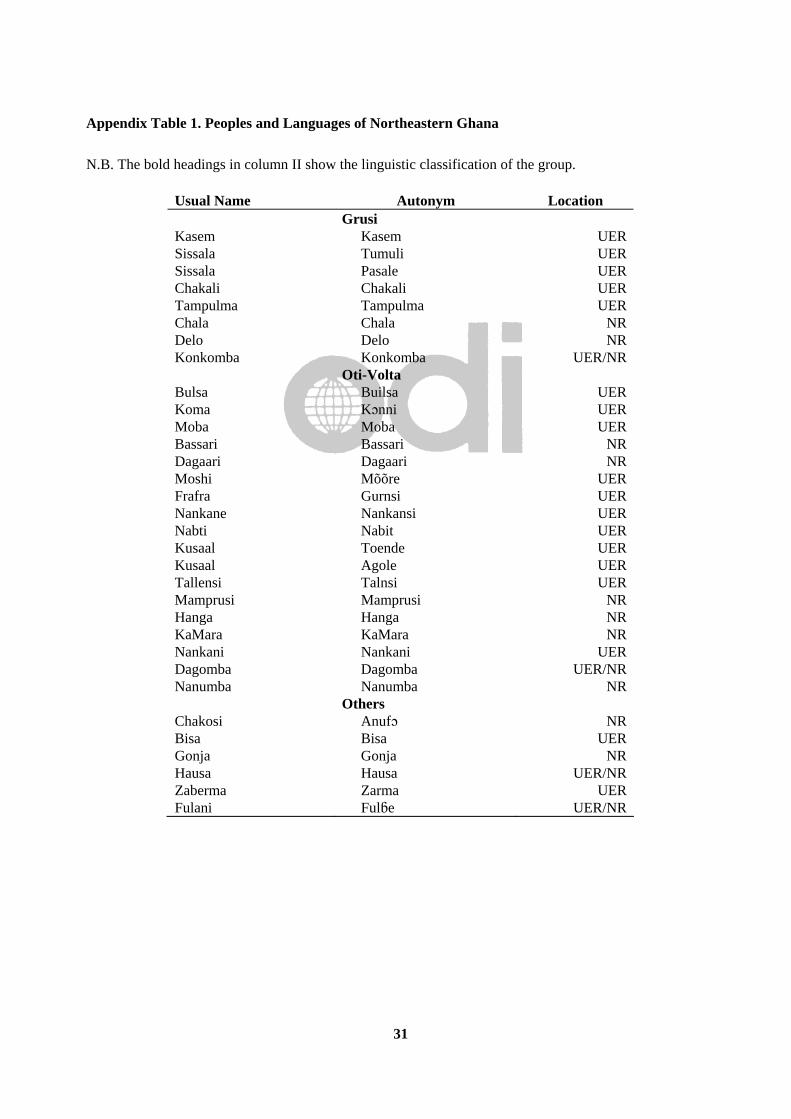
31
Appendix Table 1. Peoples and Languages of Northeastern Ghana N.B. The bold headings in column II show the linguistic classification of the group.
Usual Name Autonym Location Grusi Kasem Kasem UER Sissala Tumuli UER Sissala Pasale UER Chakali Chakali UER Tampulma Tampulma UER Chala Chala NR Delo Delo NR Konkomba Konkomba UER/NR Oti-Volta Bulsa Builsa UER Koma Kçnni UER Moba Moba UER Bassari Bassari NR Dagaari Dagaari NR Moshi Mõõre UER Frafra Gurnsi UER Nankane Nankansi UER Nabti Nabit UER Kusaal Toende UER Kusaal Agole UER Tallensi Talnsi UER Mamprusi Mamprusi NR Hanga Hanga NR KaMara KaMara NR Nankani Nankani UER Dagomba Dagomba UER/NR Nanumba Nanumba NR Others Chakosi Anufç NR Bisa Bisa UER Gonja Gonja NR Hausa Hausa UER/NR Zaberma Zarma UER Fulani Ful∫e UER/NR
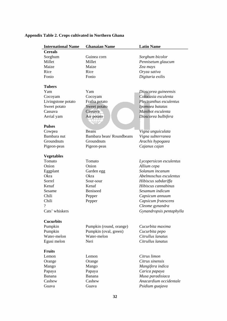
32
Appendix Table 2. Crops cultivated in Northern Ghana
International Name Ghanaian Name Latin Name Cereals Sorghum Guinea corn Sorghum bicolor Millet Millet Pennisetum glaucum Maize Maize Zea mays Rice Rice Oryza sativa Fonio Fonio Digitaria exilis Tubers Yam Yam Dioscorea guineensis Cocoyam Cocoyam Colocasia esculenta Livingstone potato Frafra potato Plectranthus esculentus Sweet potato Sweet potato Ipomoea batatas Cassava Cassava Manihot esculenta Aerial yam Air potato Dioscorea bulbifera Pulses Cowpea Beans Vigna unguiculata Bambara nut Bambara bean/ Roundbeans Vigna subterranea Groundnuts Groundnuts Arachis hypogaea Pigeon-peas Pigeon-peas Cajanus cajan Vegetables Tomato Tomato Lycopersicon esculentus Onion Onion Allium cepa Eggplant Garden egg Solanum incanum Okra Okra Abelmoschus esculentus Sorrel Sour-sour Hibiscus sabdariffa Kenaf Kenaf Hibiscus cannabinus Sesame Beniseed Sesamum indicum Chili Pepper Capsicum annuum Chili Pepper Capsicum frutescens ? Cleome gynandra Cats’ whiskers Gynandropsis pentaphylla Cucurbits Pumpkin Pumpkin (round, orange) Cucurbita maxima Pumpkin Pumpkin (oval, green) Cucurbita pepo Water-melon Water-melon Citrullus lanatus Egusi melon Neri Citrullus lanatus Fruits Lemon Lemon Citrus limon Orange Orange Citrus sinensis Mango Mango Mangifera indica Papaya Papaya Carica papaya Banana Banana Musa paradisiaca Cashew Cashew Anacardium occidentale Guava Guava Psidium guajava
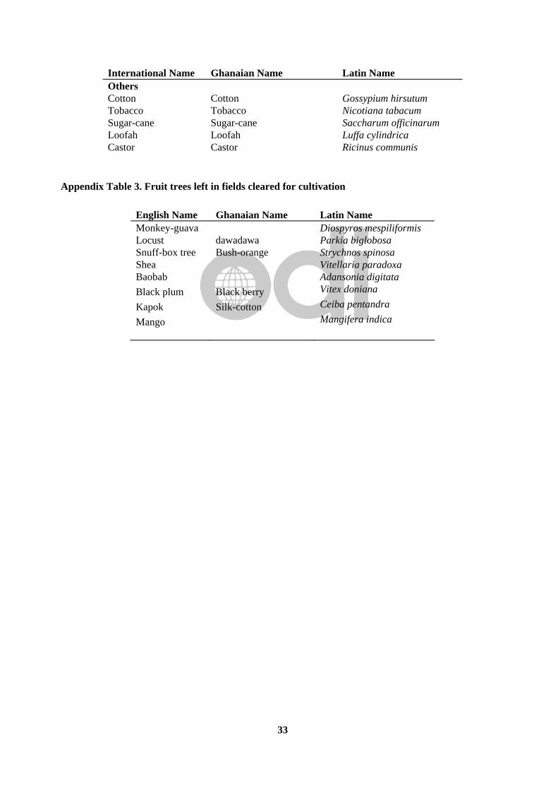
33
International Name Ghanaian Name Latin Name Others Cotton Cotton Gossypium hirsutum Tobacco Tobacco Nicotiana tabacum Sugar-cane Sugar-cane Saccharum officinarum Loofah Loofah Luffa cylindrica Castor Castor Ricinus communis
Appendix Table 3. Fruit trees left in fields cleared for cultivation
English Name Ghanaian Name Latin Name Monkey-guava Diospyros mespiliformis Locust dawadawa Parkia biglobosa Snuff-box tree Bush-orange Strychnos spinosa Shea Vitellaria paradoxa Baobab Adansonia digitata Black plum Black berry Vitex doniana
Kapok Silk-cotton Ceiba pentandra
Mango Mangifera indica

34
References N.B. This list includes all references encountered during research for this paper. Some are not directly referenced in the body of the paper or are otherwise incomplete. Abdulai, M.S. 1986. Land tenure among the Dagomba of North Ghana: empirical evidence. Cambridge
Anthropology, 11,3:72-103. Adam, J.G. 1948. Les reliques boisées et les essences des savanes dans la zone préforestière en Guinée
française. Bulletin de la société botanique Française, 95:22-6. Adu, S.V. 1972. Eroded savanna soils of the Navrongo-Bawku area. Ghana Journal of agricultural
science, 5:3-12. Akenhead, M. 1957. Agriculture in Western Dagomba. Ghana Farmer, 1,4. Alebikiya, M.A. 1988. Equity and the transformation of peasant agriculture: the case of the church
agricultural stations in northern Ghana. MA dissertation. The Hague: Institute of Social Studies. Alebikiya, M.A. 1993. The Association of Church Development Projects (ACDEP) in Northern Ghana. Pp.
195-201 in Non-Governmental Organisations and the State in Africa. Eds. K. Wellard and J.G. Copestake. London: Routledge.
Amanor, K.S. 1996. Managing Trees in the Farming System: the perspectives of farmers. Ghana: Forestry
Department. Amanor, K., Denkabe, A. and K. Wellard. 1993. Ghana: country overview. In: Non-Governmental
Organisations and the State in Africa. eds. K. Wellard and J.G. Copestake. 183-194. London: Routledge.
Anafu, M. 1973. The impact of colonial rule on Tallensi political institutions, 1898-1967. Transactions of
the Historical Society of Ghana, 14,1:17-37. anon. 1947. Konkomba fishing. Canadian Geographical Journal, 35:122-3. anon. 1983. The Northern Region, Ghana. Vol. I. A descriptive Overview. NORRIP Technical Unit. anon. 1992. Soil degradation: a threat to Ghana. A case of the Upper East Region. Green Forum 1. Accra:
UNSO. anon. 1995. Deforestation in the North - Rural Forestry to the rescue. Environment World Quarterly, 3:8-
10. Appa Rao, S. Melak M. Mengesha and D. Sharma. 1985. Collection and Evaluation of Pearl millet
(Pennisetum americanum) germplasm from Ghana. Economic Botany, 39:25-38. Ashie Kotey, E.N. 1992. Land and tree tenure and rural forestry in the savanna areas of Ghana: the
report of a study. Huntings Technical Services.

35
Asenso-Okyere, W., S.Y. Atsu & Irene S. Obeng 1993. Communal property resources in Ghana: policies and prospects. Discussion Paper 27. ISSER, Legon, Ghana.
Aubréville, A. 1939. Forêts reliques en AOF. Revue Botanique appliqué, 19:479-484. Barker, Peter. 1986. Peoples, languages and religion in Northern Ghana. Asempa Publishers for Ghana
Evangelism Committee. Bradley, P.N. 1991. Woodfuel, women and woodlots. London: Macmillan. Bening, Raymond B. 1967. The traditional Native agriculture of the Sissalas. Legon, University of Ghana:
Unpublished BA dissertation. Bening, R.B. 1975a. Colonial development policy in northern Ghana. Bulletin of the Ghana geographical
association,17:65-79. Bening, R.B. 1975b. Foundations of the modern native states of northern Ghana. Universitas
(Ghana),5,1:116-138. Bening, R.B. 1976. Land tenure and the traditional agriculture of the Sissala. Bulletin of the Ghana
geographical association,18:15-34. Benneh, G. 1972. The response of farmers in Northern Ghana to the introduction of mixed farming: a case
study. Geografiska Annaler, Series B, 54,2:95-103. Benneh, G. 1973a. Land tenure and farming systems in a Sissala village in Northern Ghana. Bulletin de
l’IFAN, !!: 361-379. Benneh, G. 1973b. Water requirements and limitations imposed on agricultural development in Northern
Ghana. In I.M. Ofori Factors of agricultural growth in West Africa. Pp. 71-81. Legon, Ghana: Institute of Statistical, Social and Economic Research.
Benneh, G. 1973c. Population and food production in a northern savanna village of Ghana. Food and
nutrition in Africa (Ghana), 12:134-146. Benneh, G. 1976. Communal land tenure and the problem of transforming traditional agriculture in Ghana.
Journal of Administration Overseas, XV:26-33. Benneh, G. 1985. Population, disease and rural development programmes in the Upper East Region of
Ghana. In: Population and Development Projects in Africa. J.I. Clarke, M. Khogali and L.A. Kosinski eds. 206-218. Cambridge: Cambridge University Press.
Benneh, G. 1988. Types of farm labour in Northern Ghana. Research Review, NS 4(1):28-34. Benneh, G. Agyepong, G.T. and J.E. Allotey. 1990. Land degradation in Ghana. London: Commonwealth
Secretariat. Blench, R.M. 1996. The diffusion of New World Cultigens in Nigeria. In: Plantes et paysages d’Afrique.
M. Chastenet. ed. 165-210. Paris: Karthala.
36
Brinkman, A. 1990. Die sozio-ökonomisch Bedeutung der Tierhaltung in kleinbäuerlichen Betrieben der Dagomba in Nordghana. Diplomarbeit, Universität Göttingen. [English translation also exists in SARI archives, dated 1992].
Caldwell, J.C. 1967. Fertility attitudes in three economically contrasting rural regions of Ghana. Economic
Development and cultural change, 15,2:217-238. Caldwell, J.C. 1969. African rural-urban migration: the movement to Ghana’s towns. Canberra: ANU
Press. Cardinall, A.W. 1921. Customs at the death of a king of Dagomba. Man, 21, 52. Cardinall, A.W. 1925. The natives of the Northern Territories of the Gold Coast. London: Routledge. Cheshire, P.J. 1977. Land use, agricultural production, land tenure and Administration. Kumasi: Land
Administration Centre, UST. Chipp, T.F. 1922. The forest officer's handbook of the Gold Coast, Ashanti and the Northern Territories.
London: Chitsike, L.T. 1975. Aspects of agricultural development in North-East Ghana. Legon: Ph.D. dissertation. Chilalah, G.C. 1957. Advances in agriculture in Kusasi, Northern Ghana. Ghana Farmer, 1:198-201. Clacey, J.L. and Ramsay, J.M. 1955. Land use, soil and water conservation in the northern Territories of
the Gold Coast. African soils, 3:338-353. Cleveland, D.A. 1980. The population dynamics of subsistence agriculture in the West African savanna: a
village in Northeast Ghana. Ph.D. University of Arizona. Collins, W. 1960. Extension work in Kusasi (1932-1959). Ghana Farmer 4,2:64-71. Coull, G.C. 1929. Foodstuffs in the Dagomba District of the Northern Territories. Bulletin of the
Department of Agriculture of the Gold Coast, 16:203-215. Cowan, G. 1930. A note on mixed cropping in the yam-growing districts of the Northern Territories.
Bulletin of the Department of Agriculture of the Gold Coast, 22:184-192. Dadson, J.A. 1970. Socialised agriculture in Ghana, 1962-1965. Ph.D. Harvard University. Dadson, J.A. 1973. Farm size and the modernisation of agriculture in Ghana. In I.M. Ofori Factors of
agricultural growth in West Africa. Pp. 193-202. Legon, Ghana: Institute of Statistical, Social and Economic Research.
Davison, R.B. 1954. Migrant labour in the Gold Coast. Accra: Department of Economics, Achimota. 41
pp. Dery, Benedict G. 1975. Colonial land policy in the Northern territories of the Gold Coast 1900-1957.
Universitas (Ghana),4,2:127-142.
37
Devereux, Stephen. 1989. Food security, seasonality and resource allocation in Northeastern Ghana. Oxford: M. Phil. thesis.
Devereux, Stephen. 1992. Household responses to food insecurity in northeastern Ghana. Oxford: Ph.D.
thesis. Devereux, Stephen. 1993. ‘Observers are worried’: learning the language and counting the people in
northeast Ghana. In: Fieldwork in developing countries. 43-56. Boulder: Lynne Rienner. Dickson, Kwamina B. 1971a. A historical geography of Ghana. Cambridge: Cambridge University Press. Dickson, Kwamina B. 1971b. Nucleation and dispersion of rural settlements in Ghana. Ghana Social
Science Journal, 1,1:116-131. Dickson, Kwamina B. 1972. Dynamics of agricultural innovation in Northern Ghana. Ghana Social
Science Journal, 2,2:10-18. Diehl, L. and A. Runge-Metzger. 1985. Formen gartenartiger Landwirtschaft in Nordghana. Entwicklung
und Ländlicher Raum, 19,4:13-16. Diehl, L. and L. Sipkens. 1985. The development of mixed cropping technologies in northern Ghana. In:
Appropriate technologies for farmers in semi-arid West Africa. eds. H.W. Ohm and J.G. Nagy. Indiana: Purdue University.
Donhauser, F., Baur, H. and A. Langyintuo 1994. Small holder agriculture in Western Dagbon: a farming
system in Northern Ghana. Nyankpala Agricultural Research Report, 10. Nyankpala. Dresch, J. 1945. Les migrations des populations des colonies françaises vers la Gold Coast. Bulletin de
l’Association des Géographes Françaises, 171-2:84-92. Duncan-Johnstone, A.C. et al. 1931. Enquiry into the Constitution and Organisation of the Dagomba
kingdom. Accra: Government Printer. Engmann, E.V.T. 1975. Migration and population pressure in northern Ghana: a note on methodology.
Bulletin of the Ghana geographical association,17:38-55. EPC. 1992. A socio-economic survey in the Upper East region with reference to drought and
desertification control in Ghana. Report of the Environmental Protection Council, Accra. Evans, Philip 1985. The cowry economy and the maintenance of social boundaries in Northern Ghana.
Cambridge Anthropology, 10,2:29-40. Eyre-Smith, S.J. 1933. A brief review of the history and social organisation of the people of the Northern
Territories of the Gold Coast. Accra: Government Printer. Fage, J.D. 1964. Reflections on the early history of the Mossi-Dagomba group of States. In The historian
in Tropical Africa. eds. J. Vansina, R. Mauny, and L.V. Thomas, 177-191. London: Oxford University Press for the International Africa Institute.

38
FAO/IFAD. 1989. Upper East Agricultural Intensification Project. Preparation Mission, 2 vols. 149/89, IF-GHA. Rome: FAO.
Ferguson, P. Islamisation in Dagbon. Ph.D. Social Anthropology, University of Cambridge. Fortes, Meyer. 1937. Communal fishing and fishing magic in the Northern Territories of the Gold Coast.
Journal of the Royal Anthropological Institute, 67:131-142. Fortes, Meyer and S.L. Fortes. 1936. Food in the domestic economy of the Tallensi. Africa, 9:237-76. Fortes, Meyer. 1943. A note on fertility among the Tallensi of the Gold Coast. Sociological Review,
35,2:99-113. Fortes, Meyer. 1945. The dynamics of clanship among the Tallensi. London: OUP. Fortes, Meyer. 1949. The web of kinship among the Tallensi. London: OUP. Gold Coast. 1956. Report on the Northern Territories, 1955. Tamale: Government Press. Goody, J.R. 1956. The ethnography of the Northern Territories of the gold Coast, west of the White Volta.
Unpublished report to the Colonial Office. [mimeo in Archaeology and Anthropology library, University of Cambridge]
Goody, J.R. 1962. Death, property and the ancestors. Stanford: Stanford University Press. Goody, J.R. 1967 [2nd. ed.]. The social organisation of the LoWiili. London: HMSO. Goody, J.R. 1980. Rice-burning and the Green Revolution in Northern Ghana. Journal of Development
Studies, 16,2:136-155. Greenstreet, Miranda. 1972. Labor conditions in the Gold Coast during the 1930’s with particular reference
to migrant labor and the mines. The Economic Bulletin of Ghana, 2,2:32-46. Haaf, Ernst 1967. Die Kusase -eine medizinisch-ethnologische Studie über einen Stamm in Nordghana.
Stuttgart: Gustav Fischer Verlag. Hailu, Zegeye. 1990. The adoption of modern farm practices in African agriculture. Nyankpala
Agricultural Research Report 7. Nyankpala: GTZ. Hailu, Zegeye and A. Runge-Metzger. 1993. Sustainability of Land use systems. Tropical agroecology, 7. Hart, J.K. 1969. Entrepreneurs and migrants: a study of modernisation among the Frafras of Ghana.
Ph.D. Anthropology, Cambridge University. Hart, J.K. 1971a. Migration and tribal identity among the Frafras of Ghana. Journal of African and Asian
studies, 6,1. Hart, J.K. 1971b. Migration and the opportunity structure: a Ghanaian case study. In: S. Amin ed. Modern
migrations in West Africa. London: Oxford University Press. Haswell, M.R. 1953. Economics of agriculture in a savannah village. Colonial Research Studies, 8.
London: HMSO.
39
Hear, N. van 1984-5. “By-day boys” and Dariga men: casual labour versus agrarian capital in Northern
Ghana. Review of African Political economy, 31-34. Hesse, Johann in press. Changes in animal traction in Northern Ghana. Paper presented at the ATNESA
conference, Nairobi 4-7th December, 1995. To be published in the Conference Proceedings. Hill, H.L. 1930. The shea tree (Butyrospermum Parkii) in the Northern Territories. Paper XXIX, Annual
Report of the Gold Coast Agriculture Department. Hill, P. 1963. The migrant cocoa-farmers of Southern Ghana. Cambridge: Cambridge University Press. Hill, Polly 1970. The northern Ghanaian cattle trade. In P. Hill Studies in rural capitalism in West Africa.
80-140. Cambridge: Cambridge University Press. Hilton, T.E. 1959. Land planning and resettlement in Northern Ghana. Geography, 44:227-240. Hilton, T.E. 1960a. Frafra resettlement and the population problem in Zuarungu. BIFAN, Series B, 22:426-
442. Hilton, T.E. 1960b. Ghana population Atlas. London: Thomas Nelson. Hilton, T.E. 1961. Population and emigration in the Northern Territories of Ghana. Proceedings of the 6th
international West African Congress. Hilton, T.E. 1962. Notes on the history of Kusasi. Transactions of the Historical Society of Ghana, 6:79-
86. Hilton, T.E. 1968. Population growth and distribution in the Upper Region of Ghana. In The population of
Tropical Africa. J.C. Caldwell and C. Okonjo eds. Pp. 278-290. London: Longmans, Green and Co. Holden, J.J. 1965. The Zabarima conquest of north-west Ghana. Transactions of the Historical Society of
Ghana, 8:60-86. Hunter, J.M. 1965. Regional patterns of population growth in Ghana, 1948-1960. In J.B. Whittow and P.D.
Wood eds. Essays in Geography for Austin Miller. pp. 272-290. Reading: University of Reading. Hunter, J.M. 1966. River blindness in Nangodi, Northern Ghana: a hypothesis of cyclical advance and
retreat. Geographical Review, 56,3:398-416. Hunter, J.M. 1967a. Population pressure in a part of the West African savannah: a study of Nangodi,
Northeast Ghana. Annals of the Association of American Geographers, 57:101-114. Hunter, J.M. 1967b. The social roots of dispersed settlement in northern Ghana. Annals of the Association
of American Geographers, 57:338-349. Hunter, J.M. 1967c. Seasonal hunger in a part of the West African savanna: a survey of bodyweights in
Nangodi, North-East Ghana. Transactions, Institute of British Geographers, 41:167-185. Hunter, J.M. 1968. The clans of the Nangodi. Africa, 38,4:377-412.

40
Junner N.R. & T. Hirst 1946. The geology and hydrology of the Volta River Basin. Accra: Gold Coast
Geological Survey Bulletin, 19. Kessler, J.J. 1992. The influence of karité (Vitellaria paradoxa) and néré (Parkia globosa) trees on
sorghum production in Burkina Faso. Agroforestry Systems, 17:97-118. Kirby, J.P. 1987. Bush-fires and the domestication of the wild in the Northern Region: a case study.
Occasional Papers of the TICCS, 1:14-30. Kolbilla, D. and K. Wellard. 1993. Langbensi Agricultural Station: experiences of agricultural research.
Pp. 202-212 in Non-Governmental Organisations and the State in Africa. Eds. K. Wellard and J.G. Copestake. London: Routledge.
Konings, Piet 1981. Capitalist rice farming and peasant communities in Northern Ghana. Leiden: Afrika
Studiecentrum. Korem, Albin 1985. Bush fire and agricultural development in Ghana. Tema: Ghana Publishing
Corporation. Kraus, J. 1986. The political economy of agrarian regression Ghana. In S.K. Commins, M.F. Lofchie and
R. Payne eds. Africa’s agrarian crisis: the roots of famine. Boulder: Lynne Reiner. Labouret, Henri 1937. Le géographie alimentaire en Afrique occidentale. Annales de Géographie, 46:591-
610. Le Moal, G. 1960. Un aspect de l'émigration: la fixation de Voltäiques au Ghana. BIFAN, Series B,
22:446-454. Levtzion, Nehemiah. 1968. Muslims and chiefs in West Africa. Oxford: Oxford University Press. Lynn, C.W. 1937. Agriculture in North Mamprusi. Accra: Department of Agriculture Bulletin, 34. Lynn, C.W. 1942. Agriculture in North Mamprusi: a review of a decade’s progress. Farm and Forest,
3:78-83. Lynn, C.W. 1946. Land planning and resettlement in the Northern Territories of the Gold Coast. Farm and
Forest, 7(2):81-83. Mahn, C. 1980. Periodische Märkte und Zentrale Orte - Raumstrukturen und Verflechtungsbereiche in
Nord-Ghana. Heidelberg: Heidelberger Geographische Arbeiten, 59. Manoukian, M. 1952. Tribes of the Northern Territories of the Gold Coast. London: Oxford University
Press for the IAI. Mendonsa, Eugene L. 1973. Sisala Marriage. Lambda Alpha Journal of Man, 5, 2, 39-73. Mendonsa, Eugene L. 1975a. Traditional and Imposed Political Systems among the Sisala of Northern
Ghana. Savanna, 4, 2, 103-115.

41
Mendonsa, Eugene L. 1975b. Characteristics of Sisala Diviners. In The Realm of Extrahuman Agents and Audiences. A. Bharati (ed.) No. 56 in Vol. 96, World Anthropology. The Hague: Mouton.
Mendonsa, Eugene L. 1975c. The Journey of the Soul in Sisala Cosmology. Journal of Religion in Africa.
7:1-9. Mendonsa, Eugene L. 1976a. Elders, Office-Holders and Ancestors among the Sisala of Northern Ghana.
Africa 46:57-65. Mendonsa, Eugene L. 1976b. The value of Children in Sisala Society: Implications for Demographic
Change. Paper presented at the XVth International Seminar on Family Research, Lome, Togo, January. Mendonsa, Eugene L. 1976c. Aspects of Sisala Marriage Prestations. Research Review 9, 3: 23-56. Mendonsa, Eugene L. 1977a. The Soul and Sacrifice among the Sisala. Journal of Religion in Africa 8:1-
17. Mendonsa, E.L. 1977b. The Explanation of High fertility in Sisala-land, Northern Ghana. In The
persistence of high fertility: Population Prospects in the Third World. J.C. Caldwell ed. pp. 223-258. Canberra: ANU.
Mendonsa, Eugene L. 1978. Sacrifice in Sisala-land: A Test of an Economic Hypothesis. Savanna 6:129-
140. Mendonsa, Eugene L. 1980. The failure of modern farming in Sisala-land, Northern Ghana, 1967-1977.
Human organisation, 39,3:275-279. Ministry of Food and Agriculture 1958. East Dagomba agricultural and livestock survey. Tamale. Morris, K.R.S. 1946. Big game and the Northern Territory farmer. Farm and Forest, 7:21-7. Mortimore, Michael 1988. Adapting to Drought. Cambridge: Cambridge University Press. Muir, J.C. and Williams, T.L. 1930. Agriculture in the Navrongo and Zuarungu districts of the Northern
Territories of the Gold Coast. Bulletin of the Department of Agriculture of the Gold Coast, 23:230-244. Ministry of Lands and Natural Resources [MLMR]1978. Report of the Committee on ownership of Lands
and the position of tenants in the Northern and Upper Regions of Ghana. Accra: Ministry of Lands and Natural Resources.
Northcott, A.P. 1890. Report on the Northern Territories of the Gold Coast. Colonial Office, London. Norton, Andew 1987. The socio-economic background to community forestry in the Northern Region of
Ghana. 72pp + 11 maps. Accra: ODA unpublished report. Ohler, F.M.J. 1985. The fuelwood production of wooded savannah fallows in the Sudan zone of Mali.
Agroforestry systems, 3:15-23. Ollenu, N.A. 1962. Principles of Customary Land Laws in Ghana. London: Sweet and Maxwell.

42
Otsyina, Robert M. 1990. Agroforestry development in the Northern region of Ghana Unpublished report, Ministry of Agriculture/IFAD.
Panin, Anthony. 1986. A comparative analysis of hoe and bullock in farming systems in Northern Ghana.
Ph.D. thesis, Agricultural Economics, University of Göttingen. Patterson, K.D. 1978. River Blindness in northern Ghana, 1900-1950. In G.W. Hartwig and K.D.
Patterson, eds. Disease in African history. Pp. 88-117. Durham, NC: Duke University Press. Peiler, Elke 1994. Potentials and constraints of Agroforestry in Northern Ghana on the example of farmed
parkland in the vicinity of NAES with special reference to the impact of Butyrospermum parkii and Parkia biglobosa. Nyankpala: Report to GTZ/SARI.
Planning Branch. 1997. The status of savanna woodland management in the Northern Regions of Ghana
and strategies for future development. Unpublished report prepared by Planning Branch, Forestry Department, Kumasi.
Pogucki, R.J.H. 1950. Report on land tenure in native customary law of the protectorate of the Northern
territories of the Gold Coast. Land Tenure in the Gold Coast, 1. Lands Department, Accra. Poppi, Cesare 1986. The Vagla of Northern Ghana: notes towards an ethnography. Cambridge
Anthropology, 11,2:40-69. Priebe, H. 1972. Entwicklungsmöglichkeiten der traditionellen Landwirtschaft in Nordghana. Frankfurt. Quaye, E.C. 1992. Biomass energy in rural households: consumption patterns and perceptions of women.
African Arid Lands, Working Paper Series, 4/92. Scandinavian Institute of African Studies, Uppsala. Raeburn, J.R. 1950. Report on a preliminary economic survey of the Northern Territories of the Gold
Coast. Publication DS 42 702/1. London: Colonial Office. Rattray, R.S. 1932. Tribes of the Ashanti hinterland. Oxford: Oxford University Press. Riehl, V. 1989. The land is ours: ten la a ten den - research on the land use system among the Tallensi of
Northern Ghana. Research Review, University of Ghana, NS, 5,1:21-36. Rufai, A.M. 1987. Land tenure and its impact on agricultural production: a case study in the Tamale area
of Northern Ghana. B.Sc. thesis. University of Cape Coast. Runge-Metzger, A. and Diehl, L. eds. 1993. Farm household systems in northern Ghana. Nyankpala
Agricultural Research Report, 9. Eschborn: GTZ. Rouch, Jean. 1956. Migrations au Ghana (Gold Coast). Journal de la Société des Africanistes, 26:133-196. Samuels, Fiona & A. Leplaideur. 1991. Changing agrarian structure and petty commodity production in
the northern region of Ghana. Montpellier/Oxford: IRAT/Queen Elizabeth House. Schnell, R. 1957. Plantes alimentaires et vie agricole de l’Afrique noire: essai de phytogéographie
alimentaire. Paris: Larose.

43
Shepherd, A. 1981. Agrarian change in Northern Ghana. In Public investment, capitalist farming and famine in rural development in Tropical Africa. Eds. J. Heyer, P. Roberts, and G. Williams. 168-192. London: Macmillan.
Smith, R. 1948. Report on agriculture in Kusasi. Unpublished report. File No. 463. Staniland, Martin. 1975. The Lions of Dagbon: Political change in Northern Ghana. Cambridge:
Cambridge University Press. Stewart, J.L. 1940. Livestock improvement in the northern Territories of the Gold Coast. Tropical
Agriculture, Trinidad, 17:87-9. Stewart, J.L. and M.D.W. Jeffreys. 1956. The cattle of the Gold Coast. London. Tait, David. 1961. The Konkomba of Northern Ghana. London: Oxford University Press for the
International Africa Institute. Tamakloe, E.F. 1931. Brief history of the Dagomba people. Accra: Government Printer. Taylor, C.J. 1960. Synecology and silviculture in Ghana. Edinburgh: Tripp, Robert 1978. Economic strategies and nutritional status in a compound farming settlement in
Northern Ghana. Ph.D. Columbia University. Tripp, Robert 1981. Farmers and traders: some economic determinants of nutritional status in Northern
Ghana. Journal of tropical pediatrics, 27:15-22. Tripp, Robert 1982. Time allocation in Northern Ghana: an example of the random visit method. The
journal of developing areas, 16:391-400. Tripp, Robert 1992. Dietary consequences of changes in trade and agriculture for the Nankane of Northern
Ghana. Ecology of food and nutrition, 27:249-258. Uchendu, V.C. and K.R.M. Anthony. 1969. Field study of agricultural change: Bawku district, Ghana.
Food Research Institute, Stanford University. Wenner, Mark & Timothy J. Mooney 1995. Livestock trade and marketing costs in the Burkina Faso-
Ghana corridor. Final Report by MSI/Abt Associates to USAID, Africa Bureau. Veluw, K. van 1987. Traditional poultry-keeping in Northern Ghana. ILEIA Newsletter, 3,4:12-13. Vigne, C. 1936. Forests of the Northern Territories of the Gold Coast. Empire Forestry journal, 15:210-
213. Walker, H.O. 1957. Weather and climate of Ghana. Accra: Wardell, D.A. 1996. Consultancy Report on a mission for the World Bank Forestry Resource Management
Project. Accra: World Bank.

44
Warner, Michael W. 1995a. The dynamics of smallholder agriculture in the Guinea savannah zone of West Africa, with particular reference to Northern Region, Ghana. Briefing Paper 1. Dept. of Agricultural Economics, Wye College.
Warner, Michael W. 1995b. Demographic survey and preliminary case study findings. Briefing Paper 3.
Dept. of Agricultural Economics, Wye College. Warner, Michael W., R. M. Al-Hassan and J.G. Kydd. In press. Beyond gender roles? Conceptualising the
social and economic lives of rural peoples in sub-Saharan Africa. Some evidence from northern Ghana. Paper accepted for Development and change.
Webber, Paul. 1990. Ecological energetics in the West African savanna: the flow of energy in a
smallholder farming community in Kusasi, north-east Ghana. Ph.D. thesis, Centre of West African Studies, University of Birmingham.
Webber, Paul. 1996a. News from the village: agrarian change in Ghana. Geography Review, 9(3):25-30. Webber, Paul 1996b. Agrarian change in Kusasi, North-East Ghana. Africa, 66(3):437-457. West, Oliver 1965. Fire in vegetation and its use in pasture management with special reference to tropical
and subtropical Africa. England: Commonwealth Agricultural Bureaux. Wharton, F.D. Jr., J.M. Shepard and T.F. Buamah 19xx. Preliminary studies on supplemental feeding of
cattle reared under essentially "local" conditions in Northern Ghana. Ghana Journal of Science, 7,1-2:30-36.
Wills, K.B. ed. 1962. Agriculture and land use in Ghana. Oxford: Oxford University Press.