ahmadnagar - central ground water board
TRANSCRIPT

1836/BDR/2014
भारत सरकार
जल संसाधन मंत्रालय
केन्द्रीय भूममजल बोर्ड GOVT OF INDIA
MINISTRY OF WATER RESOURCES CENTRAL GROUND WATER BOARD
महाराष्ट्र राज्य के अतंर्डत अहमदनर्र जजले की भूजल विज्ञान
जानकारी GROUND WATER INFORMATION
AHMADNAGAR DISTRICT MAHARASHTRA
By द्िारा Vijesh V. K. विजेश िी. के. Scientist-B िैज्ञाननक ख
मध्य क्षेत्र, नार्पुर
CENTRAL REGION NAGPUR 2014

i
AHMADNAGAR DISTRICT AT A GLANCE
1. GENERAL INFORMATION Geographical Area 17114 sq. km Administrative Divisions
(As on 31/03/2011)
: Taluka- 14; Ahmednagar, Rahuri , Shrirampur, Nevasa, Shevgaon, Pathardi, Jamkhed, Karjat, Srigonda, Parner, Akola, Sangamner, Kopargaon and Rahata.
Villages : 1581 Population (2001) : 4,543,159 Average Annual Rainfall : 501.8 mm 2. GEOMORPHOLOGY Major Physiographic unit : 4; Hill and Ghat section; Foothill
zone; Plateau and Plains Major Drainage : 2; Godavari and Bhima 3. LAND USE (2001-02) Forest Area : 1634 sq. km. Net Area Sown : 15097 sq. km. Cultivable Area : 11463 sq. km. 4. PRINCIPAL CROPS (2011) Rabi Sorghum : 5072 sq. km. Bajra : 3622 sq. km. Wheat : 1382 sq. km. Pearlmillet : 1282 sq. km. 5. IRRIGATION BY DIFFERENT SOURCES (2006-2007)
Nos./Potential Created (ha) Dugwells : 176608 /446465 Tubewells/Borewells : 20320/ 54383 Surface flow schemes : 4374/8688 Surface lift schemes : 2432/7041 Total potential created in the district : 516576 7. GROUND WATER MONITORING WELLS (As on 31/05/2011) Dugwells : 26 Piezometers : 9 8. GEOLOGY Recent : Alluvium Upper Cretaceous-Lower Eocene : Deccan Trap Basalt 9. HYDROGEOLOGY Water Bearing Formation : Hard Rock: Deccan Traps-
Weathered/Fractured/Jointed massive or vesicular Basalt Soft Rock: Alluvium- Sand and gravel.
Premonsoon Depth to Water Level (May 2011)
: 2.15 to 19.10 m bgl (May-2011)
Postmonsoon Depth to Water Level (Nov. 2011)
: 1.40 to 19.70 m bgl (Nov-2011)
Premonsoon Water Level Trend (2001-2010)
: Rise: Negligible to 1.06 m/year Fall: 0.02 to 2.22 m/year
Postmonsoon Water Level Trend (2001-2010)
: Rise: Negligible to 1.09 m/year Fall: 0.01 to 0.82 m/year

ii
10. GROUND WATER EXPLORATION (As on 31/03/2011) Wells Drilled : EW-67, OW-25 Depth Range : 14.60 to 352 m bgl Discharge : 0.05 to 33.63 lps Transmissivity : Alluvium- 21 to 598 m2/day
Deccan Trap Basalt- 2 to 357 m2/day 11. GROUND WATER QUALITY Slightly alkaline, good for irrigation purposes throughout the district. However
potability is affected at some places due to high NO3 and TH. 12. DYNAMIC GROUND WATER RESOURCES- (As on 31/03/2009) Net Annual Ground Water
Availability : 1807.81 MCM
Annual Ground Water Draft (Irrigation+Domestic)
: 1443.22 MCM
Allocation for Domestic and Industrial requirement up to next 25 years
: 60.53 MCM
Stage of Ground Water Development
: 79.83 %
13. AWARENESS AND TRAINING ACTIVITY (As on 31/03/11) Mass Awareness Programme (MAP) : One a. Date : 06/02/2008 b. Place : Wadgaon Amli c. Participants : 300 Water Management Training
Programme (WMTP) : One
a. Date : 04 & 05/02/2008 b. Place : Ahmadnagar c. Participants : 30 14. GROUND WATER CONTROL & REGULATION Over Exploited Taluka : Rahata Critical Taluka : None Semi-Critical Taluka : 5, Sangamner, Shrirampur,
Kopargaon, Newasa and Ahmadnagar
Notified Taluka : None 15. MAJOR GROUND WATER PROBLEMS AND ISSUES The district being situated in “Rain Shadow” zone of Western Ghats, it often
suffers the drought conditions. Almost entire district covering Ahmadnagar, Rahuri , Nevasa, Shevgaon, Jamkhed, Karjat, Srigonda, Pathardi and Parner talukas comes under “Drought Area”. The ground water quality is also non-potable at many places as the concentrations of nitrate and total hardness are above desirable limit. The ground water quality is also getting affected due to industrial pollution from sugar and allied industries like Distillery and Paper. The effluent generated from these sugar and allied industries and other industries are causing environmental problems because of its improper storage and disposal without adequate treatment.

Ground Water Information
Ahmadnagar District
Contents 1.0 Introduction ...................................................................................... 1
2.0 Climate and Rainfall ........................................................................ 3
3.0 Geomorphology and Soil Types ...................................................... 4
4.0 Ground Water Scenario ................................................................... 5
4.1 Hydrogeology...................................................................................................... 5 4.2 Water Level Scenario ........................................................................................ 6 4.3 Aquifer Parameters ........................................................................................... 8
4.4 Yield of Dugwells, Tubewells and Borewells ................................................... 8 4.5 Ground Water Resources .................................................................................. 9 4.6 Ground Water Quality .................................................................................... 12
4.7 Status of Ground Water Development ........................................................... 13
5.0 Ground Water Management Strategy .......................................... 14
5.1 Ground Water Development ........................................................................... 14 5.2 Water Conservation and Artificial Recharge................................................ 16
6.0 Ground Water Related Issues and Problems ............................... 17
6.1 Industrial Ground Water Pollution ............................................................... 17
7.0 Mass Awareness and Training Activities ...................................... 19
7.1 M.A.P. and W.M.T.P. ...................................................................................... 19
7.2 Participation in Exhibition, Mela, Fair etc. ................................................... 19
8.0 Areas Notified by CGWA/SGWA ................................................. 19
9.0 Recommendations .......................................................................... 19
List of Figures 1. Location 2. Hydrogeology 3. Premonsoon Depth to Water Level (May 2011) 4. Postmonsoon Depth to Water Level (Nov. 2011) 5. Yield Potential of Aquifers
List of Tables 1. Studies undertaken by CGWB (March 2011). 2. Salient Features of Ground Water Exploration (March 2011). 3. Annual Rainfall Data (2002-2011). 4. Ground Water Resources (March 2009). 5. Classification of Ground Water Samples for Drinking based on BIS
Drinking Water Standards (IS-10500-91, Revised 2003), (May 2011). 6 Classification of Ground Water for Irrigation based on EC (May 2011). 7. Nature and Yield Potential of Aquifers. 8. Status of MAP and WMTP (March 2011).

1
Ground Water Information
Ahmadnagar District
1.0 Introduction
Ahmadnagar is the largest district of Maharashtra State in respect of area. It is situated in the central part of the State and lies between north latitudes 18°19’ and 19°59’ and east longitudes 73°37’ and 75°32’ and falls in parts of Survey of India degree sheets 47 E, 47 I, 47 M, 47 J and 47 N. It is bounded by Nashik district in the north, Aurangabad and Beed districts to the east, Osmanabad and Solapur districts to the south and Pune and Thane districts to the west. The district has a geographical area of 17114 sq. km., which is 5.54% of the total State area. It is divided in to 14 talukas namely Ahmadnagar, Rahuri , Shrirampur, Nevasa, Shevgaon, Pathardi, Jamkhed, Karjat, Srigonda, Parner, Akole, Sangamner, Kopargaon and Rahata. The population of the district is 4,543,159 as per 2011 census with density of 265 persons per sq. km. There are 18 towns and 1581villages in the district, out of which 2 villages are not habited. The district has 14 Panchayat Samitis, 8 Nagar Parishads, 1 Municipal Corporation and 1310 Gram Panchayats.
As per the land use details (2011), the district has an area of 134 sq. km. occupied by forest. The gross cultivable area of district is 15097 sq.km., whereas net area sown is 11463 sq.km.
Central Ground Water Board has taken up several studies in the district. A list of studies conducted in the district till March 2009 is presented in Table-1.
Table 1: Studies undertaken by CGWB (March 2011).
S. No.
Officer AAP Type of Survey/Study
1. Mani, V.V.S. 1967-68 Systematic ground water studies in Karjat taluka.
2. Suryanarayana, G and Srinivasan, K.
1973-74 Systematic Hydrogeological Surveys in parts of Ahmadnagar district.
3. Rao, S.S. and Srinivasan, K.
1974-75 and 1976-77
Systematic Hydrogeological Surveys in parts of Godavari basin, Ahmadnagar district.
4. Chougule, S.V. 1981-82 Systematic Hydrogeological Surveys in parts of Ahmadnagar district.
5. Kulkarni, M.R. 1994-95 Systematic Hydrogeological Surveys in parts of Ahmadnagar district.
6. Kawade, A.B. 2006-07, 2007-08 and 2008-09
Reappraisal Hydrogeological Studies in parts of Ahmadnagar district.
2
In addition to the above studies, a report on Ground Water Resources and Development Potential of Ahmadnagar District, Maharashtra was compiled during 1994-95. The report entitled “Ground Water Development Plan of Ahmadnagar District” was also prepared by Shri M. Mehta in 1987.
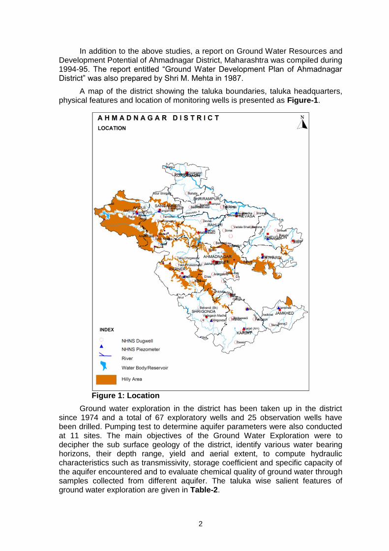
A map of the district showing the taluka boundaries, taluka headquarters, physical features and location of monitoring wells is presented as Figure-1.
Figure 1: Location
Ground water exploration in the district has been taken up in the district since 1974 and a total of 67 exploratory wells and 25 observation wells have been drilled. Pumping test to determine aquifer parameters were also conducted at 11 sites. The main objectives of the Ground Water Exploration were to decipher the sub surface geology of the district, identify various water bearing horizons, their depth range, yield and aerial extent, to compute hydraulic characteristics such as transmissivity, storage coefficient and specific capacity of the aquifer encountered and to evaluate chemical quality of ground water through samples collected from different aquifer. The taluka wise salient features of ground water exploration are given in Table-2.

3
Table-2: Salient Features of Ground Water Exploration (March 2011).
S. No.
Taluka No. of Wells Drilled
Depth Range (m bgl)
Aquifer Depth Range (m bgl)
Yield Range (lps)
1. Akole EW-5 OW-Nil
200.00 6.50 to 152.00
0.50 to 17.92
2. Sangamner EW-9 OW—2
55.00 to 200.00
3.00 to 48.00
0.80 to 13.05
3. Shrirampur EW-4 OW-1
21.00 to 200.00
19.00 to 26.80
0.20 to 0.80
4. Kopargaon EW-2 OW-Nil
200.00 - 3.17
5. Rahuri EW-4 OW-2
14.60 to 201.50
- 1.30 to 16.00
6. Newasa EW-8 OW-4
21.60 to 200.00
19.50 to 25.00
0.05 to 12.00
7. Shevgaon EW-3 OW-3
73.50 to 201.60
- 0.78 to 33.63
8. Pathardi EW-5 OW-Nil
195.04 to 200.00
- 1.73 to 2.16
9. Parner EW-7 OW-3
86.00 to 202.00
- 1.14 to 22.00
10. Shrigonda EW-6 OW-4
166.95 to 352.10
32.70 to 155.00
0.20 to 5.00
11. Karjat EW-5 OW-3
20.50 to 200.00
6.00 to 155.00
1.37 to 5.00
12. Jamkhed EW-4 OW-3
16.20 to 200.00
7.00 to 152.00
0.14 to 14.00
13. Ahmadnagar EW-5 OW-Nil
143.30 to 200.00
7.50 to 179.00
6.80 to 15.00
14. Total EW-67 OW-25
14.60 to 352.10
3.00 to 179.00
0.05 to 33.63
The ground water exploration was initiated in the district in 1974 in Godavari and Pravara River Alluvium, where 9 EW and 3 OW were constructed. Their depth ranges from 14.60 to 27.65 metres below ground level (m bgl) and the yield ranges form 0.05 to 7.14 litre per second (lps). It is observed that the thickness of Alluvium is less than 30 m. The depths of 58 exploratory and 22 observation wells drilled in Deccan Traps vary from 16.20 to 352 m bgl and the zones have been encountered in the depth range of 3 to 179 m bgl, thus deeper zones below 50 m have also been encountered in the district with the deepest being at 177 to 179 m bgl at Savedi exploratory well. The discharges vary between 0.14 to 33.63 lps.
2.0 Climate and Rainfall
The climate of the district is characterised by a hot summer and general dryness throughout the year except during the southwest monsoon season, i.e, June to September. The mean minimum temperature is 12.3°C and mean maximum temperature is 39.1°C.

4
The normal rainfall over the district varies from 484 mm to about 879 mm. Rainfall is minimum in the northern parts of the district around Kopargaon and Sangamner and it gradually increases towards southeast and reaches the maximum around Jamkhed. The district being situated in “Rain Shadow” zone of Western Ghats, it often suffers the drought conditions. Almost entire district covering Ahmadnagar, Rahuri , Nevasa, Shevgaon, Jamkhed, Karjat, Srigonda, Pathardi and Parner talukas comes under “Drought Area”. The average rainfall for the period 1995-2004 ranges from 484 mm (Kopargaon) to 879.43 mm (Akola) and the same is presented in Table-3. It is noticed that the average annual rainfall has decreased during the last 10 years period as compared to the normal annual rainfall.
Table 3: Annual Rainfall Data (2002-2011). (mm)
Taluka 2002 2003 2004 2005 2006 2007 2008 2009 2010 2011 Average
Akola 476.3 502 1354 1084 1130 871 1006 830 1041 500 879.43
Jamkhed 502 516 686 634 1020 614 729 714 839 712 696.6
Karjat 525.5 328 635 606 785 416.1 794 775 752 413 602.96
Kopargaon 337 341 479 406 571 596 401 493 760 455 483.9
Nagar 400 214 556 500 809 648 693 625 832 374 565.1
Nevasa 344 265 568 479 629 368 603 527 904 474 516.1
Parner 517.2 190 759 531 852 389.9 389 581 676 368 525.31
Pathardi 559 544 681 451 804 443.9 687 727 932 614 644.29
Rahta 475.9 263 557 601 690 462 385 447 926 395 520.19
Rahuri 325 313 575 465 796 745.5 671 686 886 589 605.15
Sangamner 492 489 650 529 589 485.7 487 452 692 240 510.57
Shevgaon 476.3 362 785 465 759 450 520 729 824 741 611.13
Shrigonda 421 110 574 484 523 752 448 651 739 326 502.8
Shrirampur 308.5 259 553 550 788 613.9 521 650 932 636 581.14
(Source: www.agri.mah.nic.in)
3.0 Geomorphology and Soil Types
Physiographically the district forms part of Deccan Plateau. Part of Sahayadri hill ranges fall in the district. Western Ghat section in Akole taluka is hilly which extends to relatively flat areas in Shevgaon and Jamkhed talukas in the east. From the main Sahayadri range three spurs namely Kalsubai, Baleshwar and Harishchandgad strech eastwards. Physiographically the district can be broadly divided in four major characteristic landforms viz., hill and ghat section (7.6% area); foothill zone (19.4% area); plateau (3.71% area) and plains (occupy 69.30% area). The district lies partly in Godavari basin and partly in Bhima basin. The northern part of the district is drained by Godavari River and its tributaries viz., Pravara, Mula, Adula and Mahalungi whereas the southern part is drained by Bhima River and its tributaries viz., Ghod and Sina. All the rivers have sub parallel to semi-dendritic drainage pattern and the drainage density is quite high. Based on geomorphological setting and drainage pattern, the district is divided into 80 watersheds.

5
4.0 Ground Water Scenario
4.1 Hydrogeology
The major part of the district is underlain by the basaltic lava flows, which were formed by the intermittent fissure type eruptions during of upper Cretaceous to lower Eocene age. The Deccan Trap has succession of 19 major flows in the elevation range of 420 to 730 m above mean sea level (amsl). These flows are characterised by the prominent units of vesicular and massive Basalt. The Alluvium of Recent age also occurs as narrow stretch along the course of major rivers deposited over the Traps. A map depicting the hydrogeological features is shown in Figure-2.
4.1.1 Hard Rock Formations
4.1.1.1 Deccan Trap Basalt
Deccan Traps occupy about 95% area of the district and it occurs as basaltic lava flows which are normally horizontally disposed over a wide stretch and give rise to table-land type of topography also known as plateau. These flows occur in layered sequence ranging in thickness from 15 to 50 m. Flows are represented by massive portion at bottom and vesicular portion at top and are separated from each other by marker bed known as bole bed. The thickness of weathering varies widely in the district form 5 to 25 m bgl. The weathered and fractured trap occurring in topographic lows form the main aquifer in the district.
The ground water occurs under phreatic, semi-confined and confined conditions. Generally the shallower zones down to the depth of 20 m bgl form phreatic aquifer. The water bearing zones occurring between the depths of 20 and 40 m are weathered interflow or shear zones and yield water under semi-confined conditions. Deeper semi-confined to confined aquifers occur below the depth of 40 m as the borewells drilled have shown presence of fractured zones at deeper depths at places. The vesicular portion of different lava flows varies in thickness from 8 to 10 m and forms the potential aquifer zones. However the nature and density of vesicles, their distribution, inter-connection, depth of weathering and topography of the area are the decisive factors for occurrence and movement of ground water in vesicular units. The massive portion of basaltic flows are devoid of water, but when it is weathered, fractured, jointed or contain weaker zones ground water occurs in it. The yield of the dugwells ranges from 2 to 3655 lpm, whereas that of borewells ranges from 500 lph to about 20000 lph when favourably located.
4.1.2 Soft Rock Formations
4.1.2.1 Alluvium
Alluvium occurs in small areas along banks and flood plains of major rivers like Godavari, Pravara, Mula rivers and their tributaries. In the Alluvium the coarse grained detrital material like sand and gravel usually occurring as lenses forms good aquifer. The ground water occurs in phreatic aquifer under water table conditions in flood plain Alluvium deposits near the river banks. Confined conditions are also found wherever the thick clay deposits confine the ground water below it. From CGWB exploration in Godavari-Pravara Alluvium it is observed that the thickness of Alluvium is less than 30 m and the aquifer thickness is limited to 3m. The yield of the dugwells ranges from about 1 to 53

6
lps, whereas in shallow tubewells it ranges form 0.08 to 7.14 lps
Figure 2: Hydrogeology
4.2 Water Level Scenario
Central Ground Water Board periodically monitors 50 National Hydrograph Network Stations (NHNS) stations in the Ahmadnagar district, four times a year i.e. in January, May (Premonsoon), August and November (Postmonsoon).
4.2.1 Depth to Water Level – Premonsoon (May-2011)
The depth to water levels in the district during premonsoon ranges between 2.15 to 19.10 m bgl l. Depth to water level during premonsoon has been depicted in Figure-3. It is observed that the most dominant water level range in the district is 5 to 10 m bgl, followed by 10 to 20 m bgl and 2 to 5 m bgl range. Shallow water levels, i.e., less than 5m bgl are observed in 2 to 3 small isolated patches, however a large patch is observed in north-eastern part of the district in parts of Nevasa taluka. The water levels in almost entire southern, northern and northwestern parts covering major parts of Jamkhed, Karjat, Shrigonda,

7
Ahmadnagar, Shrirampur, Kopargaon, Rahuri, Sangamner and Akole talukas are between 5 and 10 m bgl. Deeper water levels in the range of 10 to 20 m bgl are observed in 3-4 patches covering major part of Parner, Pathardi and Shevgaon and parts of Sangamner and Kopargaon talukas.
Figure 3: Premonsoon Depth to Water Level (May-2011)
4.2.1.1 Depth to Water Level – Postmonsoon (Nov.-2011)
The depth to water levels during postmonsoon ranges between 1.4 to 19.70 m bgl. Spatial variation in postmonsoon depth to water levels is shown in Figure-4. Water levels less than 2 m is observed in Nevas and Rahuri taluka in very small patches. The shallow water levels of 2-5 m bgl are observed in north and south parts of the district. The water levels are between 5 and 10 m bgl in the south central part and patches in southern and northern parts. Water between 10-2o m bgl is observed in patches of Nevasa, Rahata, Rahuri, Kopargaon and Jamkhed talukas and major parts of Pathardi,Shrigonda, Nagar and Parner talukas.
4.2.1.2 Seasonal Water Level Fluctuation– (May-Nov. 2011)
The Minimum ground water level fluctuation observed was at 0.05 (Rajuri ) and the maximum was reported at 10.7 (Ambikhalsa). Approximately 50% wells shows fluctuation within 0.0-2 m interval, 23 % shows 2-5 m, 27% shows 5 to 10. Pre-monsoon.

8
Figure 4: Postmonsoon Depth to Water Level (Nov.-2011)
4.2.1.3 Water Level Trend (2001-2010)
Trend of water levels for premonsoon and postmonsoon periods for last ten years (2001-2010) have been computed for 66 NHNS. Analysis revealed that during premonsoon season rise in water level in the range of Negligible (Tambhol) to 1.06 (Khadka) and fall is observed from 0.02 (Bhabuleswar) to 2.22 (Belvandi Bk.). The Post-monsoon rise varies from Negligible (Rahuri & Mirajgaon-2) to 1.09 (Dahegaon) and fall varies from 0.01 (Kopargaon) to 0.82m (Akole).
4.3 Aquifer Parameters
The aquifer parameters of water table/phreatic aquifer are available from systematic hydrogeological surveys conducted by CGWB. In Deccan Trap Basalt, the specific capacity of the dugwells ranges from 1 to 731 lpm/m of drawdown, permeability ranges from 2 to 98 m/day, and transmissivity ranges between 2 and 357 m2/day. The pumping test results of exploratory wells indicate that transmissivity ranges from 3.31 to 389.13 m2/day. In Alluvium, the specific capacity of the dugwells ranges from 60 to 691 lpm/m of drawdown, permeability ranges from 85 to 253 m/day and transmissivity ranges between 21 and 598 m2/day. In shallow tubewells the transmissivity ranges between 9.63 and 1560 m2/day, whereas specific capacity ranged between 0.26 and 8.90 lpm/m of drawdown as seen from CGWB exploration data.
4.4 Yield of Dugwells, Tubewells and Borewells
The yields of wells are functions of the permeability and transmissivity of

9
aquifer encountered and vary with location, diameter and depth etc. There are mainly two type of ground water structures i.e., dugwells and borewells in the district. Yields of dugwells vary according to the nature of formations tapped. In Deccan Trap Basalt, the yield of the dugwells ranges from 2 to 3655 lpm. The high yielding dugwells are invariably found in areas having well developed weathered and fractured zone occurring in physiographic lows. The yield of borewells shows wide variations and it varies from 0.14 lps and 33.63 lps as seen from CGWB exploration data. In Alluvium, the yield of the dugwells ranges from about 1 to 53 lps, whereas in shallow tubewells it ranges form 0.05 to 7.14 lps.
4.5 Ground Water Resources
Central Ground Water Board and Ground Water Survey and Development Agency (GSDA) have jointly estimated the ground water resources of the district based on GEC-97 methodology. The same are presented in Table-4. Ground Water Resources estimation was carried out for 15624.75 sq. km. area out of which 3681.34 sq. km. is under command and 11943.40 sq. km. is non- command.
As per the estimation the total annual ground water recharge is 1908 MCM with the natural discharge of 100 MCM, the net annual ground water availability comes to be 1807 MCM. The annual gross draft for all uses is estimated at 1443 MCM with irrigation sector being the major consumer having a draft of 1409 MCM. The annual draft for domestic and industrial uses was 34 MCM. The net ground water availability for future irrigation is estimated at 426 MCM/year. The allocation for domestic & industrial requirement supply up to next 25 years is about 61 MCM/year. The stage of ground water development varies from 53.32 % (Parner) to 107 % (Rhata). The overall stage of ground water development for the district is quite high i.e., 79.83%. The 5 talukas viz., Sangamner, Shrirampur, Kopargaon, Newasa and Ahmadnagar have been categorised as “Semi-Critical”, whereas the Rhara comes under over-exploited and the remaining in safe category. Further ground water development is not recommended without adhering to the precautionary measures i.e., artificial recharge to augment the ground water resources and adoption of ground water management practices.

10
Table-4 Taluka wise Ground Water Resources (March 2009). (Figures in ham)
Taluka Command / Non-
Command / Total
Net Annual Ground Water
Availability
Existing Gross Ground
Water Draft for irrigation
Existing Gross Ground Water
Draft for domestic and
industrial water supply
Existing Gross
Ground Water Draft for All uses
Provision for domestic
and industrial
requirement supply to
2025
Net Ground Water
Availability for future irrigation
development
Stage of Ground Water Development
%
Akola Command 769.57 378.43 8.20 386.64
Akola Non Command 8848.21 6775.02 344.48 7119.50
Akola Total 9617.79 7153.45 352.69 7506.14 546.18 3078.90 78.04
Jamkhed Command
Jamkhed Non Command 6743.97 3441.62 170.82 3612.44
Jamkhed Total 6743.97 3441.62 170.82 3612.44 341.64 2960.72 53.57
Karjat Command 1010.61 232.58 9.13 241.70
Karjat Non Command 13104.28 8755.26 160.72 8915.98
Karjat Total 14114.89 8987.84 169.84 9157.68 339.69 4787.36 64.88
Kopargaon Command 4812.89 4081.70 79.06 4160.76
Kopargaon Non Command 4022.57 3895.99 76.66 3972.65
Kopargaon Total 8835.46 7977.69 155.72 8133.41 290.14 1299.79 92.05
Nagar Command
Nagar Non Command 15152.62 12888.61 305.85 13194.46
Nagar Total 15152.62 12888.61 305.85 13194.46 609.22 1860.47 87.08
Newasa Command 14698.21 12942.11 122.38 13064.50
Newasa Non Command 5806.88 6631.95 98.31 6730.25
Newasa Total 20505.09 19574.06 220.69 19794.75 389.65 1940.75 96.54
Parner Command 5401.01 2815.76 49.80 2865.56
Parner Non Command 13481.93 6975.74 227.86 7203.60
Parner Total 18882.94 9791.50 277.66 10069.16 553.60 8544.51 53.32
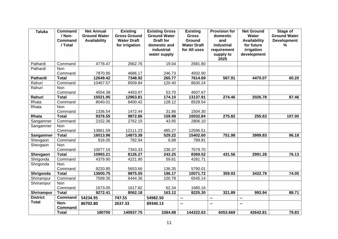
11
Taluka Command / Non-
Command / Total
Net Annual Ground Water
Availability
Existing Gross Ground
Water Draft for irrigation
Existing Gross Ground Water
Draft for domestic and
industrial water supply
Existing Gross
Ground Water Draft for All uses
Provision for domestic
and industrial
requirement supply to
2025
Net Ground Water
Availability for future irrigation
development
Stage of Ground Water Development
%
Pathardi Command 4778.47 2662.76 19.04 2681.80
Pathardi Non Command 7870.95 4686.17 246.73 4932.90
Pathardi Total 12649.42 7348.92 265.77 7614.69 567.91 4470.07 60.20
Rahuri Command 10467.57 8509.84 120.40 8630.24
Rahuri Non Command 4554.38 4453.97 53.70 4507.67
Rahuri Total 15021.95 12963.81 174.10 13137.91 274.46 2026.78 87.46
Rhata Command 8040.01 8400.42 128.12 8528.54
Rhata Non Command 1336.54 1472.44 31.86 1504.30
Rhata Total 9376.55 9872.86 159.98 10032.84 275.82 255.63 107.00
Sangamner Command 2152.36 2762.15 43.95 2806.10
Sangamner Non Command 13861.59 12111.23 485.27 12596.51
Sangamner Total 16013.96 14873.38 529.22 15402.60 751.98 3999.83 96.18
Shevgaon Command 916.05 782.94 6.88 789.81
Shevgaon Non Command 10077.16 7343.33 236.37 7579.70
Shevgaon Total 10993.21 8126.27 243.25 8369.52 431.56 2991.28 76.13
Shrigonda Command 4379.90 4221.90 59.81 4281.71
Shrigonda Non Command 9220.85 5653.66 136.35 5790.01
Shrigonda Total 13600.75 9875.55 196.17 10071.72 359.93 3432.79 74.05
Shrirampur Command 7599.35 6444.36 100.78 6545.14
Shrirampur Non Command 1673.05 1617.82 62.34 1680.16
Shrirampur Total 9272.41 8062.18 163.12 8225.30 321.89 993.94 88.71
District Total
Command 54234.95 747.55 54982.50 -- -- --
Non- Command
86702.80 2637.33 89340.13 -- -- --
Total 180700 140937.75 3384.88 144322.63 6053.669 42642.81 79.83

12
4.6 Ground Water Quality
CGWB is monitoring the ground water quality of the Ahmednagar district since the last four decades through its established monitoring wells. The objectives behind the monitoring are to develop an overall picture of the ground water quality of the district. During the year 2011, the Board has carried out the ground water quality monitoring of 15 monitoring wells. These wells mainly consist of the dug wells representing the shallow aquifer. The sampling of ground water from these wells was carried out in the month of May 2011 (pre-monsoon period). The water samples after collection were immediately subjected to the analysis of various parameters in the Regional Chemical Laboratory of the Board at Nagpur. The parameters analyzed, include pH, Electrical Conductivity (EC), Total Hardness (TH), Nitrate (NO3) and Fluoride (F). The sample collection, preservation, storage, transportation and analysis were carried out as per the standard methods given in the manual of American Public Health Association for the Examination of Water and Wastewater (APHA, 1998). The ground water quality data thus generated was first checked for completeness and then the validation of data was carried out using standard checks. Subsequently, the interpretation of data was carried out to develop the overall picture of ground water quality in the district in the year 2011.
Suitability of Ground Water for Drinking Purpose
The suitability of ground water for drinking purpose is determined keeping in view the effects of various chemical constituents in water on the biological system of human being. Though many ions are very essential for the growth of human, but when present in excess, have an adverse effect on human body. The standards proposed by the Bureau of Indian Standards (BIS) for drinking water (IS-10500-91, Revised 2003) were used to decide the suitability of ground water. The classification of ground water samples was carried out based on the desirable and maximum permissible limits for the parameters viz., TH, NO3 and F prescribed in the standards and is given in Table-5.
Table-5: Classification of Ground Water Samples for Drinking based on BIS Drinking Water Standards (IS-10500-91, Revised 2003)
Parameters DL MPL Samples with conc. < DL
Samples with conc. in DL-MPL
Samples with conc. >MPL
TH (mg/L) 300 600 4 8 3
NO3 (mg/L) 45 No relaxation 7 - 8
F (mg/L) 1.0 1.5 14 1 -
(Here, DL- Desirable Limit, MPL- Maximum Permissible Limit) The perusal of Table-5 shows that the concentrations of all the
parameters except nitrate in most of the samples are the maximum permissible limit of the within BIS standards. It is also seen from the Table-5 that the potability of ground water in the wells is mainly affected due to the Nitrate (NO3) as its concentration exceeds more than MPL in 50% of samples. Overall, it can be concluded that the ground water quality in the wells monitored in the district is affected because of high NO3 concentrations.

13
Suitability of Ground Water for Irrigation Purpose The water used for irrigation is an important factor in productivity of
crop, its yield and quality of irrigated crops. The quality of irrigation water depends primarily on the presence of dissolved salts and their concentrations. Electrical Conductivity (EC) and Residual Sodium Carbonate (RSC) are the most important quality criteria, which influence the water quality and its suitability for irrigation. Electrical Conductivity (EC)
The amount of dissolved ions in the water is best represented by the parameter electrical conductivity. The classification of water for irrigation based on the EC values is as follows.
Low Salinity Water (EC: 100-250 µS/cm): This water can be used for irrigation with most crops on most soils with little likelihood that salinity will develop.
Medium Salinity Water (EC: 250 – 750 µS/cm): This water can be used if moderate amount of leaching occurs. Plants with moderate salt tolerance can be grown in most cases without special practices for salinity control.
High Salinity Water (EC: 750 – 2250 µS/cm): This water cannot be used on soils with restricted drainage. Even with adequate drainage, special management for salinity control may be required and plants with good salt tolerance should be selected.
Very High Salinity Water (EC: >2250 µS/cm): This water is not suitable for irrigation under ordinary condition. The soils must be permeable, drainage must be adequate, irrigation water must be applied in excess to provide considerable leaching and very salt tolerant crops should be selected.
The classification of ground water samples collected from monitoring wells for was carried out irrigation purpose and given below in Table-6.
It is clear from the Table-6 that maximum number of samples (73%) falls under the category of high salinity water while nearly 14% of samples fall in very high salinity water category. This shows that the ground water in the pre-monsoon season from shallow aquifer in the district should be used for irrigation with proper soil and crop management practices.
Table-6: Classification of Ground Water for Irrigation based on EC.
Type EC (µS/cm) No. of Samples % of Samples
Low Salinity Water <250 Nil Nil
Medium Salinity Water 250-750 2 13.5
High Salinity Water 750-2250 11 73
Very High Salinity Water
>2250 2 13.5
Total 15 100.0
4.7 Status of Ground Water Development
Ground water development depends on many factors viz., availability, crop water requirement, socio-economic fabric and on the yield of the aquifers existing in that area.

14
The ground water is predominantly used for irrigation, as it is the major ground water utilising sector. The minor irrigation census data (2006-07) indicates that area irrigated by ground water is 5008 sq.km., whereas surface water accounts for 157 sq.km. of area and net irrigated area stands at 5165 sq.km. Thus it is clear that ground water is the major contributor (96%) and surface water is contributing only 4% to irrigation sector. There are about 1,76,608 dugwells in the district which create an irrigation potential of 4464.65 sq.km., out of which 3539.04 sq.km. of irrigation potential was utilised. In addition to this 359.31 sq.km of irrigation potential is utilised through 20,320 bore/tubewells during 2006-07.
State Government has drilled large number of borewells/tubewells fitted with hand pumps and electric motors for rural drinking water purposes in the district. In all G.S.D.A, Government of Maharashtra, in the year 2010-11 was successfully operating 8644 borewells/tubewells fitted with hand pumps and 338 borewells/tubewells fitted with electric pumps for rural water supply in the district.
5.0 Ground Water Management Strategy
Ground water has special significance for agricultural development in the State of Maharashtra. Ground water development in some parts of the State has reached a critical stage resulting in declining of ground water levels. Thus there is a need to adopt an integrated approach of development of ground water resources dovetailed with ground water augmentation to provide sustainability to ground water development.
5.1 Ground Water Development
The overall stage of ground water development for the district is 79.89%, hence ground water development in the district needs to be carried out with proper care and planning. About 95% area of the district is underlain by Deccan Traps and their yield potential varies greatly. To evolve a better development and management strategy the nature and yield potential of the aquifers occurring in different areas is given below in Table-7, whereas their areal distribution is presented n Figure-5.
Table-7: Nature and Yield Potential of Aquifers.
S. No.
Taluka Main Aquifer
Yield Potential Type of wells Suitable
1. Akole Basalt Low Dugwell and DCB
2. Sangamner Basalt Low to Medium Dugwell and DCB
3. Shrirampur Basalt Medium to High Dugwell, DCB and Borewell
4. Kopargaon Basalt Medium to High Dugwell, DCB and Borewell
5. Rahuri Basalt Medium to High Dugwell, DCB and Borewell
6. Newasa Basalt Medium to High Dugwell, DCB and Borewell
7. Shevgaon Basalt Medium to High Dugwell, DCB and Borewell
8. Pathardi Basalt Low to Medium Dugwell and DCB
9. Parner Basalt Medium to High Dugwell, DCB and Borewell
10. Shrigonda Basalt Low to High Dugwell, DCB and Borewell
11. Karjat Basalt Medium Dugwell and DCB

15
12. Jamkhed Basalt High Dugwell, DCB and Borewell
13. Ahmadnagar Basalt Low to Medium Dugwell and DCB
Bhima R.
Godavari R.
SINA R.
AKOLESANGAMNER
PARNER
KOPARGAON
SHRIGONDA
SHRIRAMPUR
RAHURI
AHMADNAGAR
NEVASA
KARJAT
PATHARDI
SHEVGAON
JAMKHED
TH
AN
E D
ISTR
ICT
N A S
I K
D I
S T
R I
C T
P U
N E
D I S
T R
I C T
SOLAPUR
DISTRICT
B E E D
A U R A N G A B A D D I S T R I C T
D I
S T
R
I C
T
OSM
ANABAD DIS
TRICT
Hard Rock
Soft Rock
Legend
High Yield
Medium Yield
Low Yield
Medium Yield
Low Yield
River
Hilly Area
Ahmednagar DistrictYield Potential
Figure-5: Yield Potential of Aquifers
A perusal of Figure- 7 indicates that isolated and small parts adjoining the hilly areas have low ground water development potential. Such areas occur in almost entire Akole taluka and parts of Sangamner, Srirampur, Pathardi, Ahmadanagar and Srigonda talukas. Major part of the district is occupied by areas with medium ground water development potential. Such areas are observed in southern part of the district comprising entire Karjat and Shrigonda talukas; in central, eastern and northern parts of the district occupying parts of Parner, Ahmadnagar, Pathardi, Shevgaon,, Nevasa, Shrirampur, Kopargaon and Sangamner talukas. The areas with high ground water development potential are observed scattered throughout the district and occupy almost entire Jamkhed taluka and parts of Shrigonda, Ahmadnagar, Parner, Shevgaon, Rahuri and Kopargaon talukas. In the hard rock areas occupied by Deccan traps the ground water can be developed through dugwells, dug-cum-bored wells and borewells. However, the dugwells are most feasible structures for ground water development. The borewells

16
generally tap deeper fractures and selection of sites for borewells needs proper scientific investigation. The yield of dugwells in the district may be expected from 20 to 120 m3/day depending on the local hydrogeological conditions.
Thus ground water development is recommended in areas with high and medium potential observed in almost entire Sangamner, Shrirampur, Kopargaon, Rahuri, Newasa, Shevgaon, Parner, Karjat, and Jamkhed talukas and parts of Ahmadnagar and Shrigonda talukas. However, while carrying out ground water development it may be noted that Sangamner, Shrirampur, Kopargaon, Newasa and Ahmadnagar talukas fall under “Semi-Critical” category, whereas in Rahuri, Shrigonda and Shevgaon the stage of ground water development is about 74%, 68% and 67% respectively. Thus future ground water development is recommended in these areas with adherence to the precautionary measures, i.e., artificial recharge to augment the ground water resources and adoption of ground water management practices, so that the sustainable development is achieved.
The Alluvial areas observed along the major rivers and their tributaries have low ground water development potential and the ground water can be developed through dugwells, dug-cum-bored wells and shallow tubewells (Depth< 30m). The yield of dugwells in the district may be expected up to 180 lpm, whereas that of shallow tubewells may be expected up to 600 lpm.
5.2 Water Conservation and Artificial Recharge
Ground water plays vital role for irrigation in the district, as a result the ground water levels are depleting in major part of the district, however the water levels are within 10 m bgl during both pre and postmonsoon in major parts of the district. To avoid over-exploitation of ground water resources, there is a need to increase irrigation facilities from surface water sources and to conserve water flowing out from area through rivers and nalas at various places by constructing different types of water conservation structures. These structures will not only prevent outgoing surface run-off from the small watersheds, but also will act as artificial recharge structures and arrest soil erosion.
In Basaltic area, the artificial recharge structures feasible are check dams, gully plugs, percolation tanks, nalla bunds, etc. Existing dugwells can also be used for artificial recharge, however, the source water should be properly filtered before being put in the wells. In almost entire Akole taluka and parts of Sangamner, Rahuri, Ahmadnagar, Pathardi and Parner talukas prominent hill ranges, isolated hillocks and undulations etc., occur which allows for the higher surface run off. Hence small schemes of water conservation are proved to be quite useful for harvesting the surface run off and there by maintaining the supply during lean period. Storage tanks for villages on hill tops, nala bunds, contour bunds, gully plugs, CCT etc., should be constructed after studying the feasibility. Under Ground Bandharas are also feasible to conserve the base flow. The most feasible artificial recharge structure suitable for Alluvial areas restricted along the banks of major rivers and their tributaries, are shallow recharge wells on the river bed of the

17
tributaries with small check dams for impounding rain water. Percolation tanks are also suitable, wherever source water availability is there.
The sites for artificial recharge structures need to be located where the hydrogeological conditions are favourable, i.e., where sufficient thickness of de-saturated/unsaturated aquifer exists and water levels are more than 5 m deep during postmonsoon and areas showing falling ground water level trends. Such areas are observed in almost entire Parner and parts of Sangamner, Rahuri, Ahmadnagar, Nevasa, Pathardi and Jamkhed.
6.0 Ground Water Related Issues and Problems
The district being situated in “Rain Shadow” zone of Western Ghats, it often suffers the drought conditions. Almost entire district covering Ahmadnagar, Rahuri , Nevasa, Shevgaon, Jamkhed, Karjat, Srigonda, Pathardi and Parner talukas comes under “Drought Area” The major parts of the district are also showing falling ground water level trends mainly in central, northern and eastern parts of the district comprising almost entire Parner, Ahmadnagar, Rahuri, Sangamner, Shrirampur and Pathardi talukas and Jamkhed taluka in south eastern part of the district and parts of Shrigonda, Sangamner, Shevgaon and Akole talukas. Thus, the future water conservation and artificial recharge structures needs to be prioritised in these areas.
The ground water quality is also non-potable at many places as the concentrations of nitrate and total hardness are above desirable limit. In such areas alternative source of drinking water needs to be located and properly maintained. Also 53% of samples are having high nitrate concentration. Continuous intake of high nitrate concentration water causes infant methaemoglobinamea, popularly known as Blue Babies disease. Thus all the wells used for water supply should be first analysed for nitrate as well as other major ions and if the contents are found beyond permissible limit the ground water may be used for other purposes than drinking. Adequate sanitary protection to the wells may be provided to control the nitrate contamination.
6.1 Industrial Ground Water Pollution
The ground water quality is also getting affected due to industrial pollution from sugar and allied industries like Distillery and Paper, which form the backbone of rural economy in the area. The effluent generated from these sugar and allied industries and other industries are causing environmental problems because of its improper storage and disposal without adequate treatment.
To study the impact of these industries on ground water quality 2 detailed studies were taken up by CGWB discussed below.
6.1.1 Sangamner Bhag Sahakari Sakhar Karkhana Ltd.( SBSSK Ltd), Mangalam Drugs & Organic Ltd., Sangamner Taluka.
The study was taken up in December 2001 and the findings and recommendations of the study are listed below.
The study undertaken indicates that the ground water has been contaminated due to the percolation of effluents from both the

18
Mangalam industries and distillery & paper unit of SBSSK Ltd.
In order to check the pollution of ground water in the area, it was recommended that the lagoons storing the untreated and treated spent wash, sludge and effluent from distillery and paper unit of SBSSK Ltd. should be lined and made leakage proof to avoid leaching of effluent into ground water. The effluent generated from both distillery and paper unit should be treated on regular basis. Irrigation even with treated effluent from paper unit should not be done as the present practice is affecting the potability of ground water by imparting colour to it after percolation.
The present status of ground water pollution raises doubts about the efficiency and efficacy of Effluent Treatment Plant (ETP) measures adopted by the industry. The persisting high degree of pollution needs effective pollution control and remedial measures.
In order to improve the ground water quality in the area by effective dilution, artificial recharge of ground water can be taken up by constructing appropriate artificial recharge structures like check dams, percolation tanks etc. at suitable site based on detailed hydrogeological survey in the area
6.1.2 Western Maharashtra Development Corporation’s (WMDC) Distillery, Chitali, Rahata Taluka.
The study was taken up during 2002-03 and the findings and recommendations of the study are listed below.
The major factor, which is contributing to ground water pollution in the area, is the percolation of spent wash to ground water, stored in unlined lagoons located on the upstream side of the village. To stop the further percolation of the spent wash to ground water, all the lagoons must be properly lined with leakage proof material.
The concentration of various parameters in treated spent wash is still very high and may affect the ground water quality if percolated. Hence, the effective effluent treatment techniques must be adopted to further bring down the concentration of various parameters.
The irrigation with spent wash and polluted ground water along with use of sludge for agriculture purpose must be stopped as it may have an adverse impact on ground water quality.
The maximum use of "Godavari Right Bank Canal System" water for irrigation may indirectly help to improve the ground water quality by dilution of polluted ground water with fresh canal water.
An artificial recharge of ground water by locating suitable recharge structure on the upstream side may also help to improve the ground water quality in the area.

19
7.0 Mass Awareness and Training Activities
7.1 M.A.P. and W.M.T.P.
Till March 2008, one MAP and one WMTP had been organised in the district. The details are given in Table-8.
Table-8: Status of MAP and WMTP (March 2011).
S. No.
Item AAP Venue Date Participants
1 MAP 2007-08 Wadgaon Amli 06/02/2008 300
2 WMTP 2007-08 Ahmadnagar 04 & 05/02/2008 30
7.2 Participation in Exhibition, Mela, Fair etc.
During the MAP at Wadgaon Amli and WMTP at Ahmadnagar, an exhibition depicting rainwater harvesting model, various ground water related posters, leaflets, literature and technical reports were displayed along with maps of Ahmadnagar district. The models, maps, posters were explained to the visitors in details.
8.0 Areas Notified by CGWA/SGWA
As per ground water resource estimation 5 talukas viz., Sangamner, Shrirampur, Kopargaon, Newasa and Ahmadnagar have been categorised as “Semi-Critical” and other talukas fall under “Safe” category. However till March 2007 the area has not been notified either by CGWA or SGWA.
9.0 Recommendations
1. The dugwells are most suitable structures for ground water development in the district as 95% of the area is covered by Deccan Trap Basalt. The sites for borewell and tubewells wherever feasible, need to be selected only after proper scientific investigation. The expected yield of dugwells may vary from 20 to 120 m3/day depending on the local hydrogeological conditions.
2. The Alluvial areas observed along the major rivers and their tributaries have low to medium ground water development potential and the ground water can be developed through dugwells, Dug-cum-bored wells and shallow tubewells (Depth< 30m). The dugwells in Alluvium are expected to yield up to 180 lpm, whereas tubewells are expected to yield up to 600 lpm.
3. The overall stage of ground water development for the district is 79.83%, hence future ground water development in the district needs to be carried out with proper care and planning using suitable ground water abstractions structures depending on the terrain, aquifer potential, quality aspects etc.
4. The ground water development is recommended in areas with high and medium potential observed in almost entire Sangamner, Shrirampur, Kopargaon, Rahuri, Newasa, Shevgaon, Parner, Karjat, and Jamkhed talukas and parts of Ahmadnagar and Shrigonda talukas with adherence to the precautionary measures, i.e., artificial recharge to augment the ground water resources and adoption of ground water

20
management practices, so that the sustainable development is achieved.
5. The scope exists for construction of suitable artificial recharge structures in the district. The sites for artificial recharge structures need to be located where the hydrogeological conditions are favourable, i.e., where sufficient thickness of de-saturated/unsaturated aquifer exists and water levels are more than 5 m deep during postmonsoon and areas showing falling ground water level trends. Such areas are observed in almost entire Parner and parts of Sangamner, Rahuri, Ahmadnagar, Nevasa, Pathardi and Jamkhed
6. In Basaltic area, the artificial recharge structures feasible are check dams, gully plugs, percolation tanks, nalla bunds, etc. Existing dugwells can also be used for artificial recharge, however, the source water should be properly filtered before being put in the wells.
7. In almost entire Akole taluka and parts of Sangamner, Rahuri, Ahmadnagar, Pathardi and Parner talukas prominent hill ranges, isolated hillocks and undulations etc., occur which allows for the higher surface run off. Hence small schemes of water conservation are proved to be quite useful for harvesting the surface run off and there by maintaining the supply during lean period. Storage tanks for villages on hill tops, nala bunds, contour bunds, gully plugs, CCT etc., should be constructed after studying the feasibility. Under Ground Bandharas are also feasible to conserve the base flow.
8. The most feasible artificial recharge structure suitable for Alluvial areas restricted along the banks of major rivers and their tributaries, are shallow recharge wells on the river bed of the tributaries with small check dams for impounding rain water. Percolation tanks are also suitable, wherever source water availability is there.
9. The existing village ponds need to be rejuvenated to act both as water conservation and artificial recharge structures.
10. In shallow aquifer potability of ground water is also affected at many places as the concentrations of most of the parameters such as TDS, and NO3 are above desirable limit. In such areas alternative source of drinking water needs to be located and properly maintained.
11. About 53% of ground water samples are having high nitrate concentration. Continuous intake of high nitrate concentration water causes infant methaemoglobinamea, popularly known as Blue Babies disease. Thus all the wells used for water supply should be first analysed for nitrate as well as other major ions and if the contents are found beyond permissible limit the ground water may be used for other purposes than drinking. Adequate sanitary protection to the wells may be provided to control the nitrate contamination.
12. The ground water quality is also getting affected due to industrial pollution from sugar and allied industries like Distillery and Paper. To stop the further pollution to ground water, all the lagoons storing the untreated and treated spent wash, sludge and effluent must be properly lined with leakage proof material.

21
13. To minimise the effects of ground water pollution, effective effluent treatment techniques must be adopted by the industries to further bring down the concentration of various parameters.
14. An artificial recharge of ground water by locating suitable recharge structure may also help to improve the ground water quality in the industrial areas