ahtna knowledge of long-term changes in salmon runs in the … papers/tp324.pdf · technical paper...
TRANSCRIPT

Technical Paper No. 324
Ahtna Knowledge of Long-Term Changes in Salmon Runs in the Upper Copper River Drainage, Alaska Final Report for Study 04-553 USFWS Office of Subsistence Management Fishery Information Service Division
by
William E. Simeone and Erica McCall Valentine,
with
Siri Tuttle
in collaboration with the Mentasta Tribal Council Cheesh’Na Tribal Council Gulkana Tribal Council Tazlina Tribal Council
August 2007
Alaska Department of Fish and Game Division of Subsistence
Symbols and Abbreviations The following symbols and abbreviations, and others approved for the Système International d'Unités (SI), are used without definition in the following reports by the Divisions of Sport Fish and of Commercial Fisheries: Fishery Manuscripts, Fishery Data Series Reports, Fishery Management Reports, and Special Publications. All others, including deviations from definitions listed below, are noted in the text at first mention, as well as in the titles or footnotes of tables, and in figure or figure captions. Weights and measures (metric) centimeter cm deciliter dL gram g hectare ha kilogram kg kilometer km liter L meter m milliliter mL millimeter mm Weights and measures (English) cubic feet per second ft3/s foot ft gallon gal inch in mile mi nautical mile nmi ounce oz pound lb quart qt yard yd Time and temperature day d degrees Celsius °C degrees Fahrenheit °F degrees kelvin K hour h minute min second s Physics and chemistry all atomic symbols alternating current AC ampere A calorie cal direct current DC hertz Hz horsepower hp hydrogen ion activity pH (negative log of) parts per million ppm parts per thousand ppt, ‰ volts V watts W
General Alaska Administrative Code AAC all commonly accepted abbreviations e.g., Mr., Mrs.,
AM, PM, etc. all commonly accepted professional titles e.g., Dr., Ph.D., R.N., etc. at @ compass directions:
east E north N south S west W
copyright © corporate suffixes:
Company Co. Corporation Corp. Incorporated Inc. Limited Ltd.
District of Columbia D.C. et alii (and others) et al. et cetera (and so forth) etc. exempli gratia (for example) e.g. Federal Information Code FIC id est (that is) i.e. latitude or longitude lat. or long. monetary symbols (U.S.) $, ¢ months (tables and figures): first three letters Jan,...,Dec registered trademark ® trademark ™ United States (adjective) U.S. United States of America (noun) USA U.S.C. United States
Code U.S. state use two-letter
abbreviations (e.g., AK, WA)
Measures (fisheries) fork length FL mideye-to-fork MEF mideye-to-tail-fork METF standard length SL total length TL Mathematics, statistics all standard mathematical signs, symbols and abbreviations alternate hypothesis HA base of natural logarithm e catch per unit effort CPUE coefficient of variation CV common test statistics (F, t, χ2, etc.) confidence interval CI correlation coefficient (multiple) R correlation coefficient (simple) r covariance cov degree (angular ) ° degrees of freedom df expected value E greater than > greater than or equal to ≥ harvest per unit effort HPUE less than < less than or equal to ≤ logarithm (natural) ln logarithm (base 10) log logarithm (specify base) log2, etc. minute (angular) ' not significant NS null hypothesis HO percent % probability P probability of a type I error (rejection of the null hypothesis when true) α probability of a type II error (acceptance of the null hypothesis when false) β second (angular) " standard deviation SD standard error SE variance population Var sample var

TECHNICAL PAPER NO. 324
Ahtna Knowledge of Long-Term Changes in Salmon Runs in the Upper Copper River Drainage, Alaska
by William E. Simeone
Division of Subsistence, Anchorage Erica McCall Valentine Native Village of Eyak
Partner Division for Fisheries Monitoring Program, Cordova Siri Tuttle
Alaska Native Language Center University of Alaska, Fairbanks
and the
Mentasta Tribal Council Cheesh’Na Tribal Council
Gulkana Tribal Council Tazlina Tribal Council
Alaska Department of Fish and Game
Division of Subsistence PO Box 115526, Juneau, Alaska, 99811-5526
August 2007
Final Report to the U.S. Fish and Wildlife Service, Office of Subsistence Management, Fisheries Resource Monitoring Program to fulfill obligations for Study No. 04-553 under agreement 701814C139.

The Division of Subsistence Technical Paper Series was established in 1979 and represents the most complete collection of information about customary and traditional uses of fish and wildlife resources in Alaska. The papers cover all regions of the state. Some papers were written in response to specific fish and game management issues. Others provide detailed, basic information on the subsistence uses of particular communities which pertain to a large number of scientific and policy questions. Technical Paper Series reports are available through the Alaska State Library and on the Internet: http://www.subsistence.adfg.state.ak.us/geninfo/publctns/techpap.cfm
William E. Simeone, Alaska Department of Fish and Game, Division of Subsistence,
333 Raspberry Road, Anchorage, AK 99518-1599, USA Erica McCall Valentine, Native Village of Eyak
Partners for Fisheries Monitoring Program, 509 1st Street P.O. Box 1388
Cordova, Alaska 99574-1388, USA Siri Tuttle,
Alaska Native Language Center, University of Alaska Fairbanks
P.O. Box757680 Fairbanks, Alaska 99775 USA
and the Mentasta Tribal Council
Cheesh’Na Tribal Council Gulkana Tribal Council Tazlina Tribal Council
This document should be cited as: Simeone, W. E., and E. McC. Valentine, 2007. Ahtna knowledge of long-term changes in salmon runs in the Upper
Copper River drainage, Alaska. Alaska Department of Fish and Game, Division of Subsistence Technical Paper No. 324. Juneau.
The Alaska Department of Fish and Game (ADF&G) administers all programs and activities free from discrimination based on race, color, national origin, age, sex, religion, marital status, pregnancy, parenthood, or disability. The department administers all programs and activities in compliance with Title VI of the Civil Rights Act of 1964, Section 504 of the Rehabilitation Act of 1973, Title II of the Americans with Disabilities Act (ADA) of 1990, the Age Discrimination Act of 1975, and Title IX of the Education Amendments of 1972. If you believe you have been discriminated against in any program, activity, or facility please write:
ADF&G ADA Coordinator, P.O. Box 115526, Juneau AK 99811-5526 U.S. Fish and Wildlife Service, 4040 N. Fairfax Drive, Suite 300 Webb, Arlington VA 22203 Office of Equal Opportunity, U.S. Department of the Interior, Washington DC 20240
The department’s ADA Coordinator can be reached via phone at the following numbers: (VOICE) 907-465-6077, (Statewide Telecommunication Device for the Deaf) 1-800-478-3648, (Juneau TDD) 907-465-3646, or (FAX) 907-465-6078
For information on alternative formats and questions on this publication, please contact: ADF&G, Division of Subsistence, Website: http://www.subsistence.adfg.state.ak.us/

i
TABLE OF CONTENTS LIST OF FIGURES......................................................................................................................................................iii LIST OF TABLES........................................................................................................................................................iii LIST OF PLATES........................................................................................................................................................iii ABSTRACT ..................................................................................................................................................................1 CHAPTER 1. INTRODUCTION..................................................................................................................................1 Research Goals and Objectives .....................................................................................................................................3 Research Methods and Materials...................................................................................................................................4 Organization of the Report ............................................................................................................................................8 Study Area: The Copper River Basin ............................................................................................................................8 CHAPTER 2. THE AHTNA AND SALMON............................................................................................................10 Introduction .................................................................................................................................................................10 The Seasonal Round ....................................................................................................................................................10 The Ahtna View of Nature and Their Relationship with Salmon................................................................................11 CHAPTER 3. THE ABUNDANCE OF SALMON AND AHTNA SALMON HARVESTS OVER TIME ..............14 Introduction .................................................................................................................................................................14 Evidence of Changes in Salmon Abundance and Productivity of the Fishery over Time ...........................................16
Scientific Sources ...................................................................................................................................................16 Anthropological Sources.........................................................................................................................................20 Archival Sources.....................................................................................................................................................23 Competition and Management................................................................................................................................32
Summary......................................................................................................................................................................38 CHAPTER 4. SALMON AT THE HEADWATERS..................................................................................................40 Introduction .................................................................................................................................................................40 Ahtna Accounts of Salmon at the Headwaters ............................................................................................................43 Archival Sources .........................................................................................................................................................47 Scientific Accounts of Headwaters Salmon Stocks .....................................................................................................49 Salmon Harvests at the Headwaters.............................................................................................................................51 Fishing At Batzulnetas, 1987 to 2005..........................................................................................................................53 Summary......................................................................................................................................................................54 CHAPTER 5. ENVIRONMENTAL CHANGE..........................................................................................................55 Introduction .................................................................................................................................................................55 Impacts on the Environment........................................................................................................................................55 Community-based Environmental Assessment: Climate Change and the Copper River Fisheries .............................56
Affects of Climate Change......................................................................................................................................56 Changes in Fish and Wildlife..................................................................................................................................60 Permafrost and Wildfires ........................................................................................................................................62 Vegetation...............................................................................................................................................................64 Erosion and Loss of Fishing Sites...........................................................................................................................65 Changing Land Ownership .....................................................................................................................................66 Pollution..................................................................................................................................................................68

ii
TABLE OF CONTENTS (Continued)
Page Summary......................................................................................................................................................................70 CHAPTER 6. AHTNA TRADTIONAL FISHERIES AND INTERACTION WITH GOVERNMENT FISHERIES MANAGEMENT....................................................................................................................................72 Introduction .................................................................................................................................................................72 The Commercial Fishery under Federal Management, 1889 to 1960..........................................................................72 The State of Alaska assumes management of the Copper River .................................................................................78 Katie John vs. the United States of America: The Batzulnetas Case, Doris Charles and Katie John Challenge State and Federal Management.............................................................................................................................................80 Summary......................................................................................................................................................................81 CHAPTER 7. SUMMARY, DISCUSSION, CONCLUSIONS AND RECOMMENDATIONS ...............................83 Summary and Discussion ............................................................................................................................................83 Recommendations .......................................................................................................................................................85 ACKNOWLEDGEMENTS.........................................................................................................................................88 LITERATURE CITED................................................................................................................................................89 APPENDIX A. AN INVENTORY OF HISTORICAL VILLAGES, FISHING SITES AND SALMON SPAWNING STREAMS IN THE COPPER RIVER BASIN ...................................................................................103
APPENDIX B. HARVEST TABLES FROM 1932 TO 1937 DATA COLLECTED BY THE DEPARTMENT OF COMMERCE U.S. BUREAU OF FISHERIES ..................................................................................................131

iii
LIST OF FIGURES Figure Page 1. Upper and middle Copper River......................................................................................................................4 2. Fishing subdistricts, upper Copper River, Alaska. ............................................................................................9 3. Copper River commercial sockeye salmon harvests from 1889 to 2004.......................................................17 4. A.H. Miller’s 1918 map of Ahtna villages and populations. .........................................................................22 5. Upper Copper River subsistence salmon harvests, 1914 to 1958..................................................................23 6. Estimated salmon harvests by month, upper Copper River subsistence fishery, 1933 to 1936.....................31 7. Total number of salmon fishing permits and harvests, Glennallen and Chitina subdistricts combined,
1960-2000. ....................................................................................................................................................34 8. Average number of fishing permits by decade Glennallen and Chitina subdistricts, combined. ..................35 9. Percentage of Copper River salmon harvests by fishery. ..............................................................................35 10. Number of sport anglers using the Gulkana, Klutina, and Tonsina rivers.....................................................36 11. Upper Ahtna salmon fisheries. ......................................................................................................................46 12. Historical Ahtna fishing sites, villages, and named salmon streams on the Copper River and major
tributaries.....................................................................................................................................................106
LIST OF TABLES Table Page 1. Notes on the commercial harvest and escapement of Copper River salmon. ................................................18 2. Historical salmon harvests recalled by Ahtna interviewees. .........................................................................21 3. Dried salmon put up by the natives of the Coppe River (from Lyman 1917b) .............................................25 4. Tabulated subsistence salmon harvests, upper Copper River, 1921 (from Baker 1921). ..............................28 5. Examples of Copper River Basin environmental changes observed by Ahtna residents. .............................57
LIST OF PLATES Plate Page 1. Ahtna house opposite the mouth of the Chetaslina River, July 19, 1900. .....................................................10 2. Salmon drying racks opposite the mouth of the Chetaslina River, July 19, 1900. ........................................11 3. Doc Billum’s salmon drying racks, Lower Tonsina, circa 1900. ..................................................................27 4. Doc Billum’s fish camp as seen from the Copper River, circa 1900.............................................................29 5. Tanada Lake at the head of the Copper River, 1938. ....................................................................................42 6. C’ecaegge or ‘river mouth’ (Batzulnetas), circa 1900. Looking northwest, downriver. ..............................43 7. C’ecaegge or ‘river mouth’ (Batzulnetas), 2005. Looking southwest or upriver toward the mouth of
Tanada Creek, which is out of view.. ............................................................................................................44 8. Mentasta Lake, one-half mile east of Mentasta Village, circa 1900..............................................................48 9. Mentasta in 1903. In the left foreground is a fish weir across Mentasta Creek. In the right background
is a large salmon drying rack.........................................................................................................................51 10. Undated photo of Batzulnetas Billy’s fish camp at the mouth of Tanada Creek...........................................52 11. Salmon drying on racks at Mentasta, early 1940s. ........................................................................................52 12. C’ecaegge or ‘river mouth.’ Tanada Creek at Batzulnetas, 2002. The fish camp is to the left in the
picture, the Copper River to the right. ...........................................................................................................53 13. C’ecaegge or ‘river mouth’, Billy Batzulnetas’ house, Copper River Basin, 1903. ......................................64 14. Nataełde ‘roasted salmon place,’ Tanada Creek, Copper River Basin, 2005. ...............................................65 15. Commercial dipnetting of salmon at Abercrombie Rapids. ..........................................................................72 16. Chief Goodlataw dipnetting for salmon in Wood Canyon. ...........................................................................73

iv

1
ABSTRACT This research combines Ahtna environmental knowledge with data from the biological and social sciences to document changes in the upper Copper River salmon fishery. Information in this report covers the period from 1989 to 2004. Ahtna elders have observed that over time, fisheries management and competition from other users have adversely affected the productivity of subsistence harvests. The Ahtna attribute effects on salmon spawning in the headwaters of the Copper River to environmental pollution and interception by commercial and recreational fishers. Since 1889, when the commercial fishing industry began, historical reports document various effects on Copper River salmon stocks and subsistence harvests. The effect of commercial fishing on the long-term abundance of salmon stocks spawning in the headwaters is uncertain. Global climate change may be playing a role in salmon abundance and subsistence harvests, but its effect is difficult to distinguish from natural variation and local environmental conditions. This project is the first of its kind to document the history of the upper Copper River salmon fishery using written historic and scientific documents and Ahtna oral accounts. It provides insights for further research on the long-term effects of human use and environmental changes on these fisheries.
Citation: Simeone, W. E. and E. McC. Valentine, 2007. Ahtna Knowledge of Long-Term Changes in Salmon Runs in the Upper Copper River Drainage, Alaska. U.S. Fish and Wildlife Service, Office of Subsistence Management, Fisheries Resources Monitoring Program, Final Report (Study No. 04-553). Alaska Department of Fish and Game, Division of Subsistence, Juneau, Alaska.
CHAPTER 1. INTRODUCTION This study documents changes in the upper Copper River salmon fishery using Ahtna environmental knowledge and data from the social and natural sciences. It is an attempt to synthesize two different, and sometimes contrasting, perspectives on the status of salmon in the Copper River Basin. The Ahtna are an Athabascan speaking people who have occupied the Copper River Valley for at least a millennium (Workman 1976). These long-term resident specialists have considerable knowledge of local fisheries and provide a historical perspective on the environmental, social, and political changes that affect the current salmon fishery. The study also draws upon a wide array of archival, management, and academic research to provide a scientific perspective. Together, Ahtna knowledge and data from the sciences can provide a broader perspective on the environment that can lead to a “broadly shared understanding of the nature, magnitude and scope…” of change that is useful to both local residents and scientists (Huntington 2002:xxv).
Fieldwork was designed in collaboration with the Ahtna communities of Mentasta, Cheesh’Na, Gulkana, and Tazlina to collect information on changes in the upper Copper River subsistence fishery from the Ahtna perspective. Two species of Copper River salmon, the sockeye Oncorhynchus nerka and the Chinook Oncorhynchus tshawytscha, have always been the mainstay of Ahtna subsistence and, as a result, the Ahtna knowledge of salmon is extensive but based on a paradigm different from scientific resource management (Simeone and Kari 2002). As Nelson (l983) has described for the Koyukon, an Athabascan speaking group on the Koyukuk and Yukon rivers, the Ahtna live in a “watchful world” where all things are to be respected.
Throughout this report we use the terms “Ahtna environmental knowledge” or “local environmental knowledge” instead of the more common phrase “traditional ecological knowledge.” The word tradition implies a static concept, like an artifact waiting to be discovered, but local knowledge is dynamic (Cruikshank 2005:4). We use the term “Ahtna knowledge” because all knowledge is essentially local. Information, whether in oral or written form, encounters successive audiences whose interpretations of what they see or hear are shaped

2
by their own contemporary concerns and localities (Cruikshank 2005:10). We use the term environment in its broadest sense to refer to the “totality of circumstances that surround one” (American Heritage Dictionary 2004), and not just to the physical environment. When Ahtna elders were asked to describe or discuss long-term changes in salmon runs in the Copper River, they did not limit their discussion to the natural environment. In chapters 3, 4, and 5, Ahtna elders describe changes in the fishery that they linked to changes in ecology, but also to increased competition for salmon, management strategies designed to provide salmon to a multitude of user groups, and changes in land status that limit people from establishing new fishing sites. They also talked about human actions that offend the salmon, such as environmental pollution and restrictions on fishing in the spawning grounds.
This report is an attempt to synthesize local environmental knowledge and science to produce an explanation for change in the Copper River salmon fishery. It is now generally recognized that the knowledge of people who have spent a lifetime on the land can increase our overall understanding of the environment and this knowledge is applicable to environmental and resource management (cf. Pitcher 1998; Feit 1998; Huntington 1999; Usher 2000; Van Daele et al. 2001; Andersen and Fleener 2001; Brown et al. 2002; Krupnik and Jolly 2002). There are, however, inherent problems in this effort, since the characteristics of each body of knowledge are in some ways mutually exclusive since each stems from a different paradigm, and differs in terms of temporal and spatial scales (Fraser et al. 2006).
Local environmental knowledge is often geographically specific, fine-grained and confined to the smallest creek, or individual harvest. Such detailed observations are limited in scope but can capture small-scale perturbations that have implications for larger ecosystems (Berkes 2002:338). Local knowledge often handles quantitative information differently than science. It is usually less precise, providing relative or qualitative information, for example, about animal populations or harvest numbers. Science produces quantitative measures that are precise and allow for more exact comparisons over time, but these measures, compared to the long-term observations of people who have spent a lifetime on the land, often have short chronologies (Cruikshank 1981; Reist 1997; Montgomery 2003).
Oral traditions are frequently timeless, collapsing or telescoping time; so do not always provide a precise chronology, which limits the possibility that scientists can date specific phenomena on the basis of oral tradition (Cruikshank 1981:73). The depth and quality of local knowledge often varies between individuals, depending on personal experience and skill in communication. In addition, elders may want to discuss or focus on topics that do not easily fit into the categories used by scientists. For example, one objective of this project is to collect local knowledge that would extend our chronologies of the Copper River salmon fishery beyond the written record. Ahtna elders preferred to discuss more recent changes in the fishery: first because they expressed a preference for talking about things they knew from firsthand experience, and second, they wanted to discuss changes related to Copper River salmon populations and their ability to harvest salmon that had occurred in their lifetime.
In summary, local environmental knowledge has been developed to serve the specific needs of local communities. It is detailed, lacks precise chronologies, but is long-term. Local knowledge and science can be used together in integrative models that address ecologically complex systems, but as Huntington (2002:xxv) notes, “…it is vitally important not only that they (researchers and indigenous communities) agree on the basic facts but that they understand how each group has acquired those facts and how they interpret them.” This report provides an opportunity to contribute to that goal.

3
Under Title VIII Section 801 of the Alaska National Interest Lands Conservation Act (ANILCA), knowledgeable local people are to have a meaningful role in resource management and subsistence uses on public lands. In addition, Section 812 of the act advises agencies to make use of the special knowledge of local residents who are engaged in subsistence uses. The Copper River salmon fishery is monitored and regulated by the Alaska Department of Fish & Game (ADF&G), the U.S. Fish & Wildlife Service (USFWS), and the National Park Service (NPS). This report contributes to federal subsistence fishery management by providing:
1. Historical information about the fishery to facilitate an understanding of long-term variations in salmon runs,
2. Information about changes in subsistence harvest patterns over time, and
3. A local perspective on the fishery to help managers improve management for the benefit of local users and facilitate communication between managers and local resource users.
RESEARCH GOALS AND OBJECTIVES The goal of this two-year project is to develop a history of the upper Copper River salmon ecosystems and the salmon fishery by combining local environmental knowledge with natural and social science data to achieve the objectives listed below:
1. Document Ahtna knowledge of long-term variations in salmon runs; long-term, as defined in this project, includes oral traditions concerning pre-contact (pre-1850) and post-contact events, including Ahtna environmental knowledge of salmon streams that are no longer productive.
2. Gather Ahtna environmental knowledge about specific streams such as Tanada Creek, Indian River, Gulkana River, and the Tonsina River.
3. Tap existing sources of Ahtna environmental knowledge that contain information about environmental change, e.g. existing taped interviews.
4. Correlate or corroborate Ahtna environmental knowledge with data from the natural and social sciences.
5. Enhance information exchange between local people, the federally recognized tribes of the Copper River Basin, and agency biologists.
6. Provide a narrative outlining an environmental history of the Copper River Basin focused on the salmon fishery.
Objectives one, three, four, and six are addressed in the main body of report. Objective two is addressed in Appendix A, which is an annotated inventory of historical villages, fishing sites, and salmon spawning streams in the Ahtna region. The fifth objective was to be addressed in community meetings but after consultation with tribal representatives it was decided to have only local residents participate in these meetings. The objective of enhancing information exchange between tribes and agency biologists was met during two meetings sponsored by Ecotrust, a non-profit international environmental organization whose goal is to maintain a sustainable environment for wild salmon in the Pacific Northwest. The purpose of the two meetings, held in April of 2005 and March of 2006, was to enhance information exchange on Copper River salmon. These meetings were attended by state and federal fisheries managers, fisheries scientists from the University of Alaska, representatives from sport and personal use fisheries,

4
and representatives from seven Ahtna communities. The reports from these two meetings are available through Ecotrust.1
RESEARCH METHODS AND MATERIALS This project was a cooperative effort between ADF&G (Division of Subsistence); the USFWS, Office of Subsistence Management, Fisheries Information Services (FIS); Mentasta Tribal Council; Cheesh’Na Tribal Council; Gulkana Tribal Council; and Tazlina Tribal Council. The research was funded under FIS project 04-553.
Research methods included community meetings, interviews with individuals, and archival and library research. While developing the investigation plan, project investigators consulted with the seven Ahtna villages and requested partnerships in conducting the research. All Ahtna village councils approved this project and four village councils – Mentasta, Cheesh’Na (Chistochina), Gulkana, and Tazlina – requested partnerships in carrying out the project goals and objectives. Mentasta and Cheesh’Na are located on the upper Copper River and Gulkana and Tazlina are located on the middle Copper River (Figure 1).
Figure 1.–Upper and middle Copper River.
1 Ecotrust, a private conservation organization, may be contacted at http://www.ecotrust.org/

5
Dr. William Simeone and Erica McCall Valentine were the co-principal investigators on this project. They collaborated on project design, literature review, and archival searches, and report preparation. Dr. Siri Tuttle served as Ahtna language consultant for the duration of the project. Local research assistants hired by their respective villages were: Shawn Sanford (Mentasta), Ramona Justin (Cheesh’Na), Marcia George (Gulkana), and Jennifer Phillips (Tazlina). The community representatives assisted in hosting the community meetings, scheduling and conducting interviews, conducting interviews, and helping to transcribe recorded interviews.
As part of the project, investigators and community assistants conducted 24 interviews. The principal investigators already knew many of the people fromprevious research and this earlier experience provided a framework for identifying knowledgeable elders who would be appropriate to interview. Interviewees were chosen based on their knowledge of and involvement in the fishery. Those interviewed for this project represented multiple generations of Ahtna fishers, covering almost a 100-year time period. Among those interviewed were grandmothers and their granddaughters, fathers and sons, a retired ADF&G area biologist, and the ADF&G area biologist (at the time of the study).
The life experience of the interviewees varied. Some of the elders who were interviewed had considerable knowledge of the fishery but no longer fished, while others were still very active in the fishery. Likewise, some younger people interviewed were actively fishing; while others had stopped fishing after they had become employed and began to raise families. Many of the younger generation had gained knowledge about the fishery through their involvement with the state and federal regulatory processes and by working for village governments.
Interviews were open-ended. We employed this method because we wanted to provide the elders with the opportunity to tell stories or develop narratives, rather than answer a set of closed questions. To start, we asked elders to tell us their life histories, including where their families had fished for salmon when they were young. We then asked them to describe how the fishery had changed over their lifetime. When interviewing younger people, we used a brief protocol that had been developed at the beginning of the project. Most of the interviews were taped using a digital recorder. The names of those interviewed are listed below.
1. Katie John was born and raised on the upper Copper River and has fished at Batzulnetas, Mentasta, and Chitina. She is well known throughout the state of Alaska for her knowledge of Ahtna culture and the Copper River fishery. She has a long record of participating in research projects on Ahtna language, history, and culture.
2. Steven John was born and raised on the upper Copper River and fished at Batzulnetas and Mentasta. Like his sister, Katie John, Steven has considerable knowledge of local Ahtna subsistence practices.
3. Gene Henry now resides in Dot Lake but was born and raised at Batzulnetas. He has participated in several research projects on Ahtna language, history, and culture.
4. Kathryn Martin is Katie John’s granddaughter and was born and raised in Mentasta and has fished at Batzulnetas for a number of years. Currently Kathryn works for Ahtna Inc. and is the head of the land department.
5. Charlie David Jr. was born at Tetlin but lives in Mentasta. He worked for the Mentasta Village Council mapping traditional subsistence areas. He provided information about Station Creek.

6
6. Jerry Charlie was born at Chistochina in the 1920s and has fished there all of his life. Both he and his wife Lena Charlie (below) have considerable knowledge of traditional Ahtna subsistence practices.
7. Lena Charlie was born at Batzulnetas but now lives in Chistochina, where she fishes with her husband. At one time Lena was a noted big game guide.
8. Wilson Justin was born at Twin Lakes on the Nabesna Road and works for the Mt. Sanford Tribal Consortium. He has considerable knowledge of Ahtna culture and subsistence practices.
9. Joneal Hicks was born in Mentasta and is the environmental coordinator for the Cheesh’Na tribal council.
10. Laura Hancock was born and raised in the upper Copper River area. During her youth she fished for salmon at various fishing sites along the upper Copper River. Throughout most of her life she and her family worked as big game guides on the north side of the Wrangell Mountains.
11. Bea Posti came to Chistochina in the early 1940s and established Posti’s Trading post.
12. Fred Ewan has, for over 80 years, fished for salmon in the Copper River. Fred is a traditional leader, well known throughout the Copper River Basin for his knowledge of Ahtna culture. He has participated in numerous research projects on Ahtna language, history, and culture.
13. Danny Ewan has lived in Gulkana and fished for salmon in the Copper River for over 80 years.
14. Robert Marshall is a well-known elder and traditional leader who was born near Chitina. He has fished in the Copper River for over 80 years. He has participated in research projects on Ahtna language, history, and culture.
15. Mae Marshall is Robert’s wife, and was born and raised in Chitina. She has fished the Copper River all of her life, and now lives in Tazlina.
16. Elmer Marshall is Robert and Mae Marshall’s son. He has fished in the Copper River for over 50 years and lives in Tazlina.
17. Cathy Dewitt fished at Tazlina when she was a girl.
18. Dorothy Shinn fished at Copper Center when she was a girl.
19. John Goodlataw is a well-known elder who was born at Chitina and has fished in the Copper River for over 60 years. He and his wife Irene, host an annual culture camp at their fish camp on the Copper River near Tazlina.
20. Irene Goodlataw is John’s wife. She is an expert fisher who was born and raised nearTazlina.
21. Pauly Jerue is from Copper Center and has fished there most of her life.
22. Lisa Yashimoto is from Copper Center and has fished there most of her life.
23. Tom Taube is an ADF&G biologist for the Division of Sport Fish; formerly the area management biologist for Upper Copper Upper Susitna drainages.
24. Ken Roberson is a retired ADF&G area biologist for the Commercial Fisheries Division.

7
In addition to conducting interviews, the principal investigators consulted archival sources, published historical accounts, scientific literature, and unpublished management reports. The archives consulted included: the Anchorage Museum of History and Art, University of Alaska Archives and Manuscript Departments in Anchorage and Fairbanks, the Alaska State Library, the National Archives in Washington D.C. and College Park, Maryland, the Archives of the Smithsonian Institution, Washington D.C., and the U.S. Geological Survey Archives, Denver Colorado. Most of the archival data pertaining to the history of the Copper River salmon fishery is housed in the National Archives, Record Group 22 of the U.S. Fish and Wildlife Service. This archive holds correspondence, reports, and harvest statistics concerning the Copper River fishery for the years 1915 to about 1940. A large number of historical photographs of the Copper River are located in the U.S. Geological Survey Archives in Denver.
Phase I of the project began on August 25, 2004 in Gulkana with a meeting of the community facilitators from the four collaborating communities: Mentasta, Cheesh’Na, Tazlina, and Gulkana. At this time, it was decided not to hold a three-day meeting at the beginning of the project, as originally proposed. A one-day workshop in each of the collaborating communities seemed more appropriate for the elders, who would be more comfortable in a small group setting in their own communities. A schedule for the meetings was arranged. Also during this phase, the principal investigators identified published and unpublished sources relevant to Ahtna history, culture, local ecology, management practices, and post-contact Copper River fishing history, including catch data.
Phase II community meetings were held to introduce the project to each community. Using images that illustrated changes in the environment, project investigators developed a PowerPoint presentation for each of the communities and asked questions about how environmental changes may have affected salmon populations over time. Also, as a basis for comparing population estimates over time and quantities of past harvests, images of salmon spawning and historical photographs of salmon on drying racks were incorporated into the PowerPoint presentations. As a result of the community meetings, a set of topics to be used in follow-up interviews and a list of potential interviewees were developed. Additionally, in Phase II a performance report was written.
Phase III of the project started on April 12, 2005 with the Copper River Salmon Workshop entitled “Elevating our collective knowledge to a common level.” Ecotrust sponsored this and one other workshop, which was held on March 28, 2006, as mentioned above. These workshops helped to meet one objective of the project, which was to enhance information exchange between the federally recognized tribes of the Copper River Basin, research scientists, and resource managers. Attendees of both conferences included representatives from various user groups, resources managers from state and federal agencies, and research scientists from various universities. For the first workshop, principal investigators, and Tazlina Village Council President, Gloria Stickwan, facilitated panels of Ahtna representatives to discuss Ahtna environmental knowledge of Copper River salmon. For the second workshop the principal investigators, along with Gloria Stickwan and the Ahtna Subsistence Committee, organized two panels of Ahtna elders and village representatives to discuss long-term changes in the fishery.
Also, during Phase III, interviews were conducted, summarized, and transcribed over the summer and fall 2005. Principal investigators and two of the four community representatives

8
also visited the archives at the Alaska Native Language Center and the University of Alaska Archives in Fairbanks. In January 2006, the principal investigators visited the National Archives, Anchorage; National Archives, College Park, Maryland; Archives of the Smithsonian Institution, Washington, D.C.; and the U.S. Geological Survey Archives, Denver, Colorado.
Finally, Phase IV of the project consisted of report preparation by the principal investigators, report review by community representatives, and acceptance of the final draft by the USFWS. This project was completed in June 2007.
ORGANIZATION OF THE REPORT The report is organized into seven chapters. Chapter 1 provides an introduction to the study. Chapter 2 includes a brief overview of traditional Ahtna salmon fishing practices and the place of salmon in Ahtna culture. Chapter 3 discusses the issue of overall abundance and productivity of the Copper River salmon fishery. Chapter 4 describes issues surrounding salmon that spawn at the headwaters of the Copper River. Chapter 5 explores environmental change and changes in run timing and distribution of the salmon populations in the Copper River Basin. The impact of these changes on the ability of the Ahtna to practice traditional fishing activities is also discussed. Chapter 6 describes the Ahtna’s various efforts to effect management. Finally, Chapter 7 discusses key findings and results of this project and provides recommendations for further research and management practices. Appendix A is an inventory of historical villages, fishing sites, and salmon spawning streams in the Copper River Basin. Appendix B provides historical harvest data on the upper Copper River subsistence fishery for the years 1932 to 1937.
STUDY AREA: THE COPPER RIVER BASIN From its source in the Wrangell Mountains, the Copper River flows 287 miles south and drains an area of 24,000 square miles into the Gulf of Alaska near the town of Cordova. In 2000, the total population of the Copper River Basin was approximately 2,600 (U.S. Dept. of Commerce 2001). The major population centers are Glennallen and the area between Glennallen and Copper Center that includes the communities of Copperville, Tazlina, and Silver Springs. Within the Copper River Basin, there are seven Ahtna villages with a total population of approximately 727 people (ibid.) (see Figure 1.)
The Federal Subsistence Board classifies all of the communities within the Basin as rural for subsistence purposes. Today, the Copper River supports multiple fisheries including (see Figure 2):
1. Federally regulated subsistence fisheries in the Glennallen and Chitina subdistricts.
2. A state regulated subsistence fishery in the Glennallen Subdistrict.
3. A state regulated commercial fishery at the mouth of the Copper River.
4. State regulated sport fishery on the Klutina and Gulkana rivers.
5. Minor sport fisheries in the Tonsina and other Copper River Clearwater tributaries.
6. A state regulated personal use dip net fishery in the Chitina Subdistrict.

9
Figure 2.–Fishing subdistricts, upper Copper River, Alaska.
Major tributaries of the Copper River include the Chitina, Tonsina, Klutina, Tazlina, Gulkana, Gakona, Sanford, Chistochina, and Slana rivers. Mountains surround the Copper River Basin. The Alaska Range rings the northern edge. To the south are the Chugach Mountains and to the west are the Talkeetna Mountains. The volcanic peaks of the Wrangell Mountains form a wall to the east. The climate is characterized by great extremes in temperature, with cold, dry winters, and warm summers.
Major faunal resources include the Nelchina and Mentasta caribou herds Rangifer tarandus, Dall sheep Ovis dalli, mountain goats Oreamnos americnus, moose Alces alces, and brown Ursus acto, and black bear Ursus americanus. Beginning in June, sockeye and Chinook salmon ascend the Copper River to spawn, and in August and September, small runs of coho salmon Oncorhynchus kisutch and steelhead trout Onchorhynchus mykiss follow. Of these, sockeye salmon are the most abundant. Freshwater fish present in the Basin include rainbow trout Oncorhynchus mykiss and lake trout Salvelinus namaycush, grayling Thymallus thymallus, humpback whitefish Coregonus nasus, round whitefish Prosopium cylinradeum, and burbot Lota lota.
Glennallen subdistrict
Chitina subdistrict
Batzulnetas
N

10
CHAPTER 2. THE AHTNA AND SALMON “They just used what they needed and let the rest go” (Elmer Marshall 2005).
INTRODUCTION This chapter provides background on the Ahtna’s use of salmon and the place of salmon in Ahtna culture. The chapter begins with a description of the seasonal round as practiced by the Ahtna up until about 1940, and is followed by a discussion of the Ahtna’s view of nature and their relationship with salmon. Of the three species of salmon found in the Copper River and its tributaries, sockeye were the most important because of their abundance; they were also easier to dry than Chinook and arrived earlier than coho salmon. The Ahtna ate salmon fresh, dried, or fermented; they boiled the heads to make fish oil and fed the backbones to the dogs. Ahtna elder Robert Marshall (2004) said if there were no salmon, people would not survive over the winter. “Fish is what keeps them going. Dry it in summer and live on it all winter—if it wasn’t for that, a lot of people would starve.”
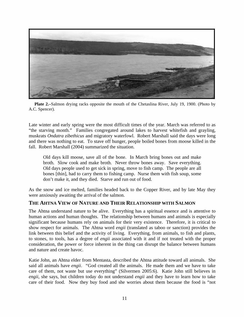
THE SEASONAL ROUND The seasonal round, as practiced by the Ahtna until about the beginning of the World War II, has been described in many sources (cf. de Laguna and McClellan 1981; Reckord 1983b) and this summary highlights data our respondents emphasized. From late May until mid-July people gathered at fishing sites to take advantage of the large salmon runs (Plates 1 and 2). Food supplies were low and the salmon harvest was critical to their survival. At this time of year, salmon supplied more nutrition for the least amount of effort, compared to any other area resource. By the end of July salmon runs had started to diminish, and rising water levels and rainy weather made harvesting and drying salmon difficult, so it was more productive for people to move upland to hunt moose, sheep, and caribou, and harvest late summer vegetable and berry products.
Plate 1.–Ahtna house opposite the mouth of the Chetaslina River, July 19, 1900. (Photo by A.C. Spencer).
Before freeze-up, sometime in October, families left the mountains and moved to multi-family semisubterranean winter houses on the banks of the Copper River or on the shores of large inland lakes. Once the ground was frozen, young men brought dried meat to the caches near the winter houses, which supplemented the stored salmon. As supplies ran low, families scattered to hunt big game and to fish through the ice in the lakes for lake trout and burbot.
11
Plate 2.–Salmon drying racks opposite the mouth of the Chetaslina River, July 19, 1900. (Photo by
A.C. Spencer).
Late winter and early spring were the most difficult times of the year. March was referred to as “the starving month.” Families congregated around lakes to harvest whitefish and grayling, muskrats Ondatra zibethicus and migratory waterfowl. Robert Marshall said the days were long and there was nothing to eat. To stave off hunger, people boiled bones from moose killed in the fall. Robert Marshall (2004) summarized the situation.
Old days kill moose, save all of the bone. In March bring bones out and make broth. Slow cook and make broth. Never throw bones away. Save everything. Old days people used to get sick in spring, move to fish camp. The people are all bones [thin], had to carry them to fishing camp. Nurse them with fish soup, some don’t make it, and they died. Starve and run out of food.
As the snow and ice melted, families headed back to the Copper River, and by late May they were anxiously awaiting the arrival of the salmon.
THE AHTNA VIEW OF NATURE AND THEIR RELATIONSHIP WITH SALMON The Ahtna understand nature to be alive. Everything has a spiritual essence and is attentive to human actions and human thoughts. The relationship between humans and animals is especially significant because humans rely on animals for their very existence. Therefore, it is critical to show respect for animals. The Ahtna word engii (translated as taboo or sanction) provides the link between this belief and the activity of living. Everything, from animals, to fish and plants, to stones, to tools, has a degree of engii associated with it and if not treated with the proper consideration, the power or force inherent in the thing can disrupt the balance between humans and nature and create havoc.
Katie John, an Ahtna elder from Mentasta, described the Ahtna attitude toward all animals. She said all animals have engii. “God created all the animals. He made them and we have to take care of them, not waste but use everything” (Silvermen 2005:6). Katie John still believes in engii, she says, but children today do not understand engii and they have to learn how to take care of their food. Now they buy food and she worries about them because the food is “not

12
blessed.” She said, “God needs to bless that food.” Katie John explained that salmon have more engii than any other animal because they travel great distances to return home to die:
Fish [salmon] is more engii than other animals that walk around. Because fish goes down to the ocean, and after four years, he comes back to die. That why they call engii. They got to take care really good, the fish (Silverman 2005:6).
Because salmon were so important, numerous rules surrounded every aspect of the harvest. Most of these rules are no longer explicitly observed, though some people continue to acknowledge that they are important. To please the salmon, the ends of dip net handles were carved in the shape of a salmon’s tail. At the start of the fishing season, the old fish racks were burned and new ones built. According to Bell Joe (Simeone and Kari 2002), an Ahtna elder from Chistochina, no metal was to be used in the construction of fish racks (or fish wheels) and the small end of the poles used in making the racks had to point upstream. Virginia Pete (ibid.), an elder from Tazlina, said that people should take “delicate care” of the fish and not throw them around but carry them “just like a baby.” Any wood associated with processing fish had to be trimmed “nice and clean” so that knots would not snag the meat of the dried salmon. The appearance of the dried fish was also of concern, and parents were cautious about teaching their daughters how to properly cut fish because they were afraid they might ruin them. Young girls who were first learning how to cut fish sometimes had their work placed in the lower portion of the fish rack so their mistakes would be hidden from view.
If a small Chinook salmon, (representing Bac’its’aadi, the little salmon boy), was caught, it was not clubbed to death but was covered with bird down and laid on the bank to die (Simeone and Kari 2002). Similarly, when the very first salmon of the season was caught, it was not to be clubbed to death but left on the grass to die. Before eating the first fish of the season, all of the adults bathed in a little bit of salmon blood or milt “so you won’t get sick,” put on new clothes, and painted their faces. Feathers were tied to the heads of women and children, “like a sign, so the fish would not make them sick” (quoted in de Laguna 1970a:23-24). Katie John (n.d. b) said this was done for luck when hunting and trapping “so that things [animals] would come to them nicely.” The fish was then cooked, usually boiled, and willow leaves were laid on top of it, “like parsley.” After eating, it was essential that people continue to fish until the run was over in order to maintain their good luck.
To please the salmon, their entire carcass had to be used. The flesh was dried, backbones were used for dog food, fish skins made into waterproof boots, and the heads boiled to make soup or to render fish oil. Bell Joe (Simeone and Kari 2002:51) linked the use of every part of the fish to fishing success. He said:
Everything, we just dry everything. That’s why long time ago lota fish. Now this time [currently] you can’t do it [catch a lot of fish]. Some time 10 [fish] a day, [or] 20, that mean he don’t take care of fish that’s why.
In order to take advantage of run strength and weather conditions, the principal fishing season began in late May or early June and continued through the middle of July. Weather was a primary factor influencing salmon runs, as well as the ability of people to fish, and the production of ba’ or dried salmon. Hot weather melted the ice and snow at higher elevations, creating runoff that raised the water levels in the streams and rivers that fed the mainstem of the
13
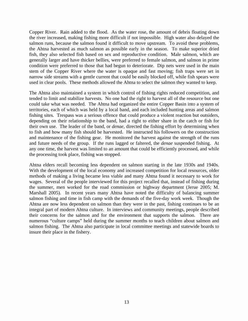
Copper River. Rain added to the flood. As the water rose, the amount of debris floating down the river increased, making fishing more difficult if not impossible. High water also delayed the salmon runs, because the salmon found it difficult to move upstream. To avoid these problems, the Ahtna harvested as much salmon as possible early in the season. To make superior dried fish, they also selected fish based on sex and reproductive condition. Male salmon, which are generally larger and have thicker bellies, were preferred to female salmon, and salmon in prime condition were preferred to those that had begun to deteriorate. Dip nets were used in the main stem of the Copper River where the water is opaque and fast moving; fish traps were set in narrow side streams with a gentle current that could be easily blocked off, while fish spears were used in clear pools. These methods allowed the Ahtna to select the salmon they wanted to keep.
The Ahtna also maintained a system in which control of fishing rights reduced competition, and tended to limit and stabilize harvests. No one had the right to harvest all of the resource but one could take what was needed. The Ahtna had organized the entire Copper Basin into a system of territories, each of which was held by a local band, and each included hunting areas and salmon fishing sites. Trespass was a serious offence that could produce a violent reaction but outsiders, depending on their relationship to the band, had a right to either share in the catch or fish for their own use. The leader of the band, or denae, directed the fishing effort by determining when to fish and how many fish should be harvested. He instructed his followers on the construction and maintenance of the fishing gear. He monitored the harvest against the strength of the runs and future needs of the group. If the runs lagged or faltered, the denae suspended fishing. At any one time, the harvest was limited to an amount that could be efficiently processed, and while the processing took place, fishing was stopped.
Ahtna elders recall becoming less dependent on salmon starting in the late 1930s and 1940s. With the development of the local economy and increased competition for local resources, older methods of making a living became less viable and many Ahtna found it necessary to work for wages. Several of the people interviewed for this project recalled that, instead of fishing during the summer, men worked for the road commission or highway department (Jerue 2005; M. Marshall 2005). In recent years many Ahtna have noted the difficulty of balancing summer salmon fishing and time in fish camp with the demands of the five-day work week. Though the Ahtna are now less dependent on salmon than they were in the past, fishing continues to be an integral part of modern Ahtna culture. In interviews and community meetings, people described their concerns for the salmon and for the environment that supports the salmon. There are numerous “culture camps” held during the summer months to teach children about salmon and salmon fishing. The Ahtna also participate in local committee meetings and statewide boards to insure their place in the fishery.

14
CHAPTER 3. THE ABUNDANCE OF SALMON AND AHTNA SALMON HARVESTS OVER TIME
INTRODUCTION When asked about the abundance of salmon in the past, most Ahtna elders who grew up in the 1920s and 1930s remembered that there was always “enough fish.” They remembered that their families dried and baled hundreds if not thousands of fish in a season. They have vivid recollections as children carrying salmon from the fish wheel to the cutting table, from the table to the smoking racks, and finally to the caches. They recall eating a lot of salmon during the summer and late winter, to the extent that some no longer like it. Elder Fred Ewan (2005) remembered “they had salmon all of the time,” but conceded that runs were sometimes scarce so people went hungry. Wilson Justin (2005) thinks there were two times within the past 100 years when salmon abundance was down. Both events occurred before 1920 and were related to the operations of the commercial fishery in Abercrombie Canyon and Miles Lake and the intense fishing effort during World War I (ibid.).
Ahtna elders also remember catching hundreds of fish in one night, something they say rarely happens today. Some elders believe this change is because there are fewer fish. Others say that the number of fish is the same but that management and competition from other fishers have affected the productivity of their fish wheels. During an interview conducted for this project in 2005, Ahtna elder Robert Marshall summed up the point of view of many elders when he said that when he was a young man (in the 1920s and 30s), his family’s fish wheel caught 200 or 300 fish a night. Today, the way the ADF&G allocates fish to various user groups and regulates the amount of fish in the river has reduced the harvest of individual fish wheels. He also points out that many more people, including sport fishers harvesting Chinook salmon on the Gulkana River, are now involved in the fishery and this has also had an adverse effect on local harvests. Marshall explains the changes he has seen in the fishery.
From the old days fishing and now is a way different. There is a commercial fishing going on down there, they allow so much fish to get, they allow so much fish to come up here. So compared to the old days and now I'd say there is about fifty percent different [less] than what we used to and now, in fish wheel.
I can run the fish wheel all day and probably get about thirty/forty fish. Them days I can run fish wheel one day and one night and I can get two-three hundred fish. So that’s how much different it is from the old days and now. Of course they control that, fish department controls that, they know how much fish they want to get up here to spawn and they allow so many fish for commercial fishermen to get. This year the least kings ever come up in the river, and I think most of that problem is, you remember when two or three years ago when Kenai people moved in here with couple hundred boats and cleaned out that Gulkana River and caught all the kings? I blame it on that. I believe the kings will be slow next year too. Sometimes we get two or three, compared to 10 or 12 [Chinooks]. There was not many fish [Chinooks] this year, but salmon were about the same. The fish is about the same amount though. That is about all I could tell you about fishing (R. Marshall 2005).

15
Marshall describes two aspects of abundance; one is the absolute number of fish and the other is the distribution of salmon in the river. The distribution of the salmon refers to their arrival at a given location and the density of fish at that point. When Marshall was growing up in the 1920s and 1930s, the upriver subsistence fishery was unregulated and the only competition was the commercial fishery at the mouth of the river. Once the salmon entered the river, nothing stood between them and the Ahtna. Elmer Marshall (2005), Robert Marshall’s son, explained what he believed was the effect of management and competition on the amount and timing of fish coming up the river.
I think the reason there [was] more fish back in the old days, is because there [was] less commercial fishermens in Cordova. Their method of fishing back then was sailboats, it wasn’t as fishing as they are now. There is a lot more fishermen’s down there [now]. Cause they [the Ahtna] had all the fish to themselves up here back then. Talking to Katie John, she said the [Tanada] creek where they fish, the fish used to plug the creek with fish. They just used what they needed and let the rest go. Now they don’t get anything (E. Marshall 2005).
After Alaska became a state in 1958 the situation on the Copper River changed. The upriver fishery became highly regulated and competition increased so that now there are five different user groups vying for Copper River salmon:
1. The commercial fishery that operates in the Copper River Delta and Prince William Sound,
2. The personal use dip net fishery that fishes in the Chitina Subdistrict that is downstream of the Chitina Bridge to about 200 yards upstream of Haley Creek,
3. A subsistence fishery located along the mainstem of the Copper River downstream of the mouth of the Slana River to the Chitina-McCarthy Bridge,
4. A subsistence fishery located at Batzulnetas on the upper Copper River, and
5. Sport fisheries in the Tonsina, Klutina, and Gulkana rivers (see Figure 2).
Of the fisheries on the upper Copper River, the personal use dip net fishery is the largest both in terms of the number of permits and the amount of harvest. Since 1984 this fishery has taken between 10 and 20 % of the total annual harvest of the instream fisheries (Simeone and Fall 2003).
To manage the growth of the fishery and ensure that enough fish get upriver to spawn, fishery managers strictly regulate every aspect of the fishery, including starting and stopping the dip net fishery based on the number of fish in the river. This has an effect not only on how salmon are distributed throughout the river but, according to Marshall, on fish wheel productivity. In this chapter we begin with an examination of the scientific literature on the abundance of salmon, followed by an evaluation of the historical record on salmon abundance and subsistence harvests up until 1960. We then explore the development of competition and management of the Copper River salmon fisheries.

16
EVIDENCE OF CHANGES IN SALMON ABUNDANCE AND PRODUCTIVITY OF THE FISHERY OVER TIME Scientific Sources Salmon populations in the North Pacific Ocean fluctuate in response to long-term and short-term cycles of climate change. Sediment cores extracted from lakes on Kodiak Island reveal evidence of long-term changes in the prehistoric abundance of salmon in the North Pacific (Finney et al. 2002: 729-733; Montgomery 2003:42-43). Salmon return to lakes to die and their rotting carcasses leak nitrogen that becomes incorporated into the sediments at the bottom of the lakes. The relative abundance of the isotope nitrogen 15 (15N) in the lake sediment indicates the relative proportion of nitrogen derived from marine sources (Finney et al. 2002). The nitrogen concentration in each layer provides an estimate of the amount of nitrogen imported from marine waters by salmon. Dating the layers in the core creates a “paleo-salmon meter” (Montgomery 2003:41). Lake cores show variation in salmon abundance over a 2,200-year period. Large swings in the abundance of salmon coincide with changes in climate. Before A.D. 800 the climate was warmer and salmon not as abundant, but as the climate cooled in the northeastern Pacific Ocean the number of salmon increased (Finney et al. 2002). The sediment cores indicate that from A.D. 1200 to 1900 there was a sustained high abundance of salmon that corresponds to the cooling trend in Alaska (ibid.).
Salmon also respond to shorter cycles called the Pacific Decadal Oscillation (PDO), which lasts between 20 to 30 years. Changes in the PDO are called “regime shifts” and relate to changes in atmospheric pressure that produce an upwelling of cold, nutrient rich bottom water. This cools ocean temperatures in the central Pacific and produces an environment beneficial to salmon. The PDO also brings warm moist air into Alaska from the south, increasing rainfall and stream flow that favors the survival of juvenile salmon (Mantua et al. 1997:1077). As ocean temperatures increase, the amount of nutrients drop and the warm water attracts other fish that compete with the salmon. The result is a boom-bust cycle in salmon production. During the 20th century there appears to have been four regime shifts in the PDO: 1900-1924, 1925-1946, 1947-1976 and 1977 to the present (Francis et al. 1998:10-12).
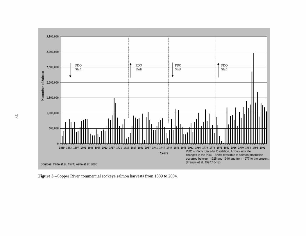
Figure 3 represents commercial sockeye salmon harvests from 1889 through 2004.2 Table 1 includes notes on the commercial harvest and escapement taken from the historical record for the years 1918 through 1953. It should be noted that for the years 1889 to 1903 represented in the figure, the harvest totals include salmon from Prince William Sound, as well as the Copper River. After fishing closed on the Copper River for the season, fishers harvested salmon in small streams tributary to Prince William Sound in order to meet their quotas. Up until 1904 the catches from the two areas were combined to produce the total harvest (Thompson 1964:14).
Using the commercial harvest as an index for abundance, data indicate that the Copper River has been more productive over the last 20 years than at any time since records have been kept (cf. Mantua et al. 1997; Downton and Miller 1998; Hare and Mantua 2000), who have used commercial harvests as an index for abundance). Climate shifts (or shifts in the PDO) are represented on the figure as arrows. Intervention analysis was used to determine whether changes in commercial sockeye salmon harvest levels from 1889-2004 in the Copper River corresponded to climate shifts in the North Pacific Ocean. As noted above, polarity reversals 2 There is no comparable time series for escapement or upriver salmon harvests.
17
Figure 3.–Copper River commercial sockeye salmon harvests from 1889 to 2004.

18
Table 1.–Notes on the commercial harvest and escapement of Copper River salmon.
1918 Harvest exceeded one million fish. Five companies operating with 50,000 fathoms of gill nets in Copper River Delta, 5400 fathoms inriver along with 30 dip nets (Bower 1919).
1924 White Act passed by Congress. New regulations issued June 1924: commercial fishing will not begin before midnight of May 25 of each year. The 36 hour closed period is extended to 60 hours from Friday to Monday morning (Bower 1925).
1925 Low harvests probably the result of scarcity of salmon (Bower 1926). 1926 Escapement considered “unsatisfactory.” The river had been "over fished in former years and is
in less satisfactory condition than any other large salmon stream in Alaska" (Bower 1927). 1928 Run of sockeye salmon reported to be small (Bower 1929). 1935 Labor troubles prevented operations, most fish escaped to spawning grounds. Small run of
sockeyes anticipated, beneficial escapement.1 1937 Larger run of sockeye salmon than usual. Stormy weather hampered operations first 3 weeks.
Escapement of sockeye in tributaries the best it had been for several years. 1938 Good run of sockeye. Escapement to upper river very satisfactory, stormy weather reduced the
commercial take. 1939 Better than average escapement, heavy early run passed upriver prior to commercial fishing. 1940 Run was unexpectedly light in view of commercial fishing and highly satisfactory escapement at
beginning of cycle in 1935. Escapement was a disappointment. Survey by airplane revealed poor escapement.
1941 Run was a keen disappointment and escapement was poor. 1942 Run and escapement seemed adequate. Escapement aided by stormy weather - prevented
commercial fishing four days at peak of run. 1943 Runs were good. Direct observations of spawning grounds impracticable. Indications that
escapement were adequate. 1944 Runs, though late, produced largest pack since (rest unclear). 1945 Excellent runs, favorable weather. Largest pack since 1937. Good upstream migrations observed,
and reports from spawning areas indicate escapement better than average. 1946 Total pack below average, escapements below average. 1947 Runs light, pack smallest since 1927. Escapements considered fair. 1948 Runs poor, production small, escapement believed to have paralleled the catch. 1949 Labor trouble, unfavorable ice conditions, fishing began last week of May. Good catches. Good
escapements observed on the spawning grounds that we could visit. 1950 Early runs large. Labor troubles, unfavorable weather, fishing began on May 22. Thus larger
portion of the fish reached the spawning grounds. 1951 Run better than in 1950. Weather hampered fishing, also weekly closed period totaling 96 hours.
Despite 33% increase in fishing gear, escapement believed to be improved. 1952 Labor disputes, operations begin two weeks late. Run so great that all-time record pack
produced. Escapement very good. 1953 Run was fair (less than half as large as 1952 production although 25% more gear operated).
Escapement believed adequate. Labor dispute delayed fishing until May 21. 1 Source: For years 1935 through 1953, RG 22 USFWS Records of the Branch of Alaska Fisheries, Records
Relating to Copper River Investigations, 1904-56, Box 1.
19
occurred in 1925, 1947, and 1977 (Francis et al. 1998:10-12).3 Previous studies found that sockeye harvests in central Alaska decreased in 1947-1976, compared to harvest levels in 1925-1946, and increased substantially in 1977-1996 (Mantua et al. 1997). In the Copper River, harvests increased significantly following the 1977 PDO polarity reversal, by an average of 358,000 fish per year from 1977 to 2005, but harvest levels did not appear to respond to PDO reversals in 1925 and 1947.
Several factors should be taken into consideration when using the commercial harvest as an indicator of abundance. First, fishing effort is not constant over time but across neighboring years (as within a particular PDO "decade" of interest), effort is relatively constant (or oscillates around a mean) so that the general level of the harvest can reflect actual abundance. However, effort changes over time or other big events affect the harvest. For example, developing fisheries undergo start-up periods where effort increases (often steadily) over many years. Legislative changes (such as the White Act which restricted commercial fishing in the Copper River) also affect effort and harvest and there are periods of protracted low effort (during economic depressions and strikes), and periods of high effort (during war and prosperity). All of these factors may strongly affect the overall level of harvest within a time series for a fair period of time, or result in sudden "dips" and "peaks” (R. P. Marshall personal communication).
A shift in the PDO is one reason for an increase in the abundance of salmon in the Copper River after 1976-1977. Another is the contribution made by the Gulkana hatchery, which, along with other salmon hatcheries in Alaska, was developed in response to record low wild stock runs in the 1960s and 1970s. The hatcheries were designed to enhance or supplement common property fisheries and not to supplement wild spawning populations or rebuild depressed wild stocks (Heard n.d.:1). The Gulkana Hatchery was founded in 1973 and is located 260 miles from the Gulf of Alaska near the headwaters of the Gulkana River. From 1973 to 1980, hatchery capacity expanded yearly as natural production declined, but demand for Copper River salmon increased (see Figure 2) (PWSAC 2006). By 1984, Gulkana was the largest sockeye fry production facility worldwide, with egg takes of 26 million (ibid.). Between 1987 and 2004, the hatchery contribution varied between 5% and 56% for an average 20% of the total commercial harvest. Hatchery production may have also assisted the increasing abundance by providing a large number of outmigrating smolts at the time of improved marine survival (Beamish and Bouillon 1992:1015). In summary, commercial harvest data indicate that since 1982 there has been an increase in the overall abundance of salmon, due, in part, to a cyclical change in the environment that began in the North Pacific Ocean during the winter of 1976-77, as well as contributions from the Gulkana hatchery.4
Ahtna elders, however, have seen their harvests and the productivity of their fish wheels decline. From their perspective, salmon are less abundant than they were 60 or 70 years ago. The difference in perspective is explained, at least in part, by the fact that the elders focus on the productivity of their individual fish wheels, comparing past performance, when there was less competition and management, with the current situation. 3 To evaluate whether salmon harvests changed following each polarity reversal we followed the modeling
approach described in more detail in Mantua et al. 1997. 4 Some researchers believe that changes in the abundance of salmon in the North Pacific Ocean over the past 100
years have more to do with cyclical changes in the environment than with management. According to Beamish and Boullion (1993:1013), “trends in salmon production from 1925 until 1989 were not primarily the result of fishing effort, management actions, or artificial rearing, but rather trends in abundance were strongly linked to the environment.”

20
Anthropological Sources The anthropological record for the Ahtna’s pre-contact use of salmon is meager. Very few archaeological sites have been excavated in the Copper River Basin and in those sites that have been excavated few salmon remains have been found (cf. Shinkwin 1979; Workman 1976; BIA 1993). In part this is because salmon bones deteriorate rapidly in the alkaline soil of the basin. Using data from comparable anthropological sources and historical data from other parts of Alaska, we estimated that before 1840 the Ahtna consumed, on an annual per capita basis, approximately 1,200 pounds of salmon (Simeone and Kari 2002:60-62). With a population of approximately 1,100 people (ibid.), the Ahtna required a total of 400,000 fish annually (or 1,308,450 pounds), or 400 fish per capita (dividing by a factor of 3, the average weight of a processed sockeye salmon).5
Salmon harvest data gathered by the U.S. Bureau of Fisheries between 1914 and 1937, and the recollections of Ahtna elders, who fished in the 1920s and 1930s (Table 2), suggest annual harvests of between 20,000 and 40,000 fish, or an annual average of 30,000 salmon. This is less than 10% (6.8%) of the estimated mid-19th century salmon harvests. One reasons for the decline in harvest was a drop in the Ahtna population. By the end of the 19th century, epidemics, such as the smallpox epidemic of 1837-1839, and later, tuberculosis that became endemic in the 1890s (de Laguna and McClellan 1981), reduced the Ahtna population to around 300 people (Abercrombie 1900:578-579), just a little over one-quarter (27%) of the estimated precontact (pre-1840) numbers. In 1915 U.S. Bureau of Fisheries agent E.M. Ball (Ball 1915a) counted 292 Ahtna and the following year agent J.H. Lyman (Lyman 1916a) counted 298 Ahtna. Figure 4, a map made in November 1918 by A. H. Miller of the U.S. Bureau of Education, shows the distribution of Ahtna communities with a total population of 337. Note that map also shows commercial fishing operations in Abercrombie Rapides and Miles Lake. The broken lines in Miles Lake represent commercial gill nets.
5 We developed this estimate based on the work of Gordon Hewes (1973). In estimating the productivity of pre-
contact Native fisheries along the Pacific Coast of North America, including Alaska, Hewes calculated that 2,000 calories per day was the normal dietary requirement for an individual, although he believed that was low for Alaska. He also assumed that 50 % of this requirement would be derived from salmon, and that one pound of fresh salmon contained nearly 1,000 calories. Hewes cited various historical data on the consumption of salmon in Alaska. Dall (1870) estimated that in the 1860s, 26,843 Alaska Natives consumed 12,000,000 fish. Hewes converted this to pounds using a factor of five for a total per capita consumption of 2,220 pounds for all Alaska Natives. Bean (1887) estimated the consumption of dried salmon on Kodiak and Afognak Islands at between 930 and 958 pounds per capita. Osgood (1971) thought, in light of his experience on the Yukon River in the 1930s, that an annual consumption of 1,000 pounds per capita was not excessive. Using Mooney and Kroeber’s population estimates, Hewes estimated 500 Ahtna would consume 300,000 pounds of salmon or 600 pounds per capita a year, or 1.64 pounds of fish per day. Averaging Hewes (600 lbs), Bean (938 lbs), Dall (2,220 lbs), and Osgood (1,000 lbs) we estimated an annual per capita consumption of salmon at 1,189 pounds. That equals 100,000 fish using a factor of 3, the average weight for a processed sockeye salmon. Hewes estimated the pre-contact Ahtna population at 500; McClellan (1975) thought it never exceeded 1,000, while Grinev (1993) estimated it at 1,500, and Townsend (1980) at 800. The average of these figures yields a pre-contact population of 1,100 Ahtna. Multiplying the annual per capita consumption of salmon (1,189 lbs) by 1,100 we arrived at a total of 1,308,450 pounds, or 436,150 fish. This far exceeds contemporary per capita harvests on the Copper River but is close to the harvest levels of modern Nondalton (768 lbs per capita), a remote Athabascan community that relies heavily on a mix of salmon, other fish, caribou and moose for subsistence. Note that Hewes’ estimate of 600 pounds per capita is below that of Nondalton, which has access to commercial foods.

21
Table 2.–Historical salmon harvests recalled by Ahtna interviewees.
Approximate Estimated Source Time Period Location Amount described by interviewee Number of salmonISER Tape # unknown 1910 Suslota 40 balesa of salmon 1,680ISER Tape 31 After 1910 Tyi sla'a' (Billums) 40 bales of salmon 1,680ISER Tape 4 1911 Copper Center 1,000 salmon 1,000U.S. Dept. of Commerce1917b Dry Creek - Gakona 400 salmon 400U.S. Dept. of Commerce1917 Dry Creek - Gakona 10 fish wheels had a average of 50 salmon 500U.S. Dept. of Commerce1917 Copper Center 17 fish wheels, 4,080 sockeye, 507 chinook 4,587ISER Tape 15 1917 Tazlina Lake One bale of fish [salmon] 42ISER Tape 4 1916-17 Copper Center 500-600 salmon 550Ahtna Tape 119.1 Before 1930 Batzulnetas 50 bales of salmon 2,100ISER Tape 12 Before 1934 Chistochina 50 bales, fish [salmon] in ground, salted 2,100ISER Tape 21 Before 1937 Chitina 8 families - 700 salmon each 5,600ISER Tape 16 Before 1937 Horse Creek 500 salmon, 50 chinook 550ISER Tape 12 1934 - 1944 Batzulnetas 60 bales of salmon 2,520ISER Tape 12 After 1944 Chistochina 300 salmon 300ISER Tape 4 1940s Mile 105 Richardson 200 - 300 salmon 250ISER Tape 28 1925 -1942 Riverstack 100 bales of fish; 5 bales of chinook salmon 4,200ISER Tape 28 1932 - 56 Chitina 10 bales of sockeye and 2 of coho 420ISER Tape 20 Before 1948 Gulkana Airport Over 2,000 salmon, 80 bales 3,360ISER Tape 29 Before 1942 Batzulnetas 70 bales of salmon 2,800ISER Tape # unknown 1932-1945 Gakona 30 to 50 bales depending on the year 1,260 - 2,100Ahtna Tape 110 1940s Gakona 800 fish [salmon] in one nightISER Tape # unknown Before 1944 Gulkana Airport 20, 21 bales, some people get 50 bales, "smaller
family gets less fish" 840-2,100 ISER Tape # unknown Before 1940 Simpson Hill 1,000 fish [salmon] 1,000ISER Tape # unknown Before 1952 Gulkana Airport 75 bales of sockeye and 20 bales of chinook in a pea 3,150ISER Tape 14 Before 1950 Klawasi Na' 30 bales of salmon; 100 steelhead 1,260ISER Tape 20 After 1955 Gulkana Village 200 salmon - fishwheel not in a good place 200ISER Tape 16 After 1958 5 Mile (Chitina Airport) 187 sockeye and 5 Chinook 192ISER Tape 17 Before 1960 Chitina 1,000 salmon (also steelhead and coho) 1,000
a One bale of sockeye salmon was made up of 40 or 42 fish, a bale of Chinook salmon was composed of 25 to 30 fish. b 1917 was considered a poor year for fishing on the upper river, because of the activities of the commercial fishery on the lower river. Sources: The Institute for Social and Economic Research (ISER) (1996); Ahtna Tapes housed in the Alaska Native Language Center. In
collaboration with the National Park Wervice and the Copper River Native Association, ISER conducted research on traditional Ahtna subsistence patterns. The tapes referred to in the table were made during the research and were transcribed by the Copper River Native Association.

22
Figure 4.–A.H. Miller’s 1918 map of Ahtna villages and populations.
Source: RG 22 Records of the US Fish and Wildlife Service, Box 2 Copper River Investigations, Dr. Ward 1919, Copper River Investigations and Closures. National Archives, Washington, D.C.
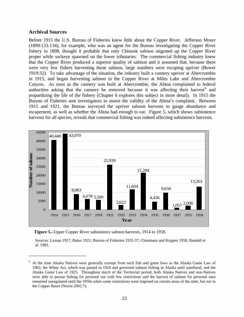
23
Archival Sources Before 1915 the U.S. Bureau of Fisheries knew little about the Copper River. Jefferson Moser (1899:133-134), for example, who was an agent for the Bureau investigating the Copper River fishery in 1898, thought it probable that only Chinook salmon migrated up the Copper River proper while sockeye spawned on the lower tributaries. The commercial fishing industry knew that the Copper River produced a superior quality of salmon and it assumed that, because there were very few fishers harvesting those salmon, large numbers were escaping upriver (Bower 1919:32). To take advantage of the situation, the industry built a cannery upriver at Abercrombie in 1915, and began harvesting salmon in the Copper River at Miles Lake and Abercrombie Canyon. As soon as the cannery was built at Abercrombie, the Ahtna complained to federal authorities asking that the cannery be removed because it was affecting their harvest6 and jeopardizing the life of the fishery (Chapter 6 explores this subject in more detail). In 1915 the Bureau of Fisheries sent investigators to assess the validity of the Ahtna’s complaint. Between 1915 and 1921, the Bureau surveyed the upriver salmon harvests to gauge abundance and escapement, as well as whether the Ahtna had enough to eat. Figure 5, which shows subsistence harvests for all species, reveals that commercial fishing was indeed affecting subsistence harvests.
,
8,883
25,939
4,436
9,658
2,096
40,440
2,622
11,604
21,294
5,5006,078
43,970
13,263
1,0570
5000
10000
15000
20000
25000
30000
35000
40000
45000
1914 1915 1916 1917 1918 1921 1932 1933 1934 1935 1936 1937 1955 1958Year
Num
ber
of sa
lmon
Figure 5.–Upper Copper River subsistence salmon harvests, 1914 to 1958.
6 At the time Alaska Natives were generally exempt from such fish and game laws as the Alaska Game Law of
1902; the White Act, which was passed in 1924 and governed salmon fishing in Alaska until statehood, and the Alaska Game Law of 1925. Throughout much of the Territorial period, both Alaska Natives and non-Natives were able to pursue fishing for personal use with few restrictions and the harvest of salmon for personal uses remained unregulated until the 1950s when some restrictions were imposed on certain areas of the state, but not in the Copper Basin (Norris 2002:7).
Sources: Lyman 1917; Baker 1921; Bureau of Fisheries 1932-37; Clemmans and Koppen 1958; Randall et al. 1983.

24
Harvests of 1914-1918: During the winter of 1915-1916 and the summer of 1917, J.H. Lyman, a warden for the Alaska Fisheries Service, visited several upriver communities and recorded their harvests. Table 3 records “dried salmon put up by the Natives of the Copper River “ and reveals that, in both 1914 and 1915, the upriver fishers harvested over 40,000 salmon, but in 1916 there was a drastic decline in the harvest that was attributed directly to the activities of the inriver commercial fishery. Lyman provided some details about the harvest data he collected. Regarding the 1914 and 1915 harvest tallies, he (1916a) wrote that the Ahtna at Copper Center, where 50% of the Native fishing took place, had government supervision in recording their harvests so that the catch represented an “honest effort.” He adds that almost all of the fishing at Copper Center was done with fish wheels, which “made it possible to make a very fair statement as to how the catch of 1915 compares with 1914” (1916a). Lyman also reports that the Ahtna in the Copper Center region caught a “normal supply of salmon” in 1915 but that the Native people were “unanimous in their declaration that the fish are on the decrease, that much more work is required to catch their supply now than in years past.”7
Lyman never visited the upper Ahtna at Chistochina or Mentasta, relying on others to provide him with information about this part of the river. In 1916 Lyman secured only “authentic” reports from a single resident of this area, who told him that the upper Copper River had experienced “light” salmon runs for several years (prior to 1915), and the runs were so light that people were forced to extend their hunting activities to make up for the lack of fish (Lyman 1916b). Also missing from Lyman’s 1915 data are harvests from two fish wheels at Liebstag, a village located ten miles above the mouth of the Tonsina River. A local non-Native resident told Lyman that in 1915 the residents of the village had sold a ton (approximately 2,250 fish) of dried salmon to the Chitina Cash Store and the U.S. military (Lyman 1916b).
Lyman’s harvest figures include dried salmon sold for dog food that cost between four and five cents a pound. In the early 20th century, dog teams were the principal means of transportation in the winter and “absolutely necessary” to the development of the country. The 1915 harvest for Copper Center included approximately two tons of dried salmon (4,500 fish) that were sold to local roadhouses and the U.S. Signal Corps. The owners of the Chitina Cash Store testified to Lyman that the previous year (1914) they had purchased or traded for merchandise six tons of dried salmon, but in 1915 could only obtain two tons.
Lyman made another trip up the Copper River in 1917, collecting harvest data from local fishers. He observed, “some localities were marked by an extreme scarcity of fish, the natives hardly securing a sufficient number for the daily needs. Thirty-seven wheels were operated during the season” (1917a). Lyman calculated that in 1917 the Ahtna needed 32,800 fish annually (ibid.). He estimated that there were 80 Ahtna families living in the Copper River Basin and that each family required eight bales or 320 salmon for the winter. This was a total of 25,600 salmon for all 80 families. In addition, Lyman estimated that during the fishing season all 80 families consumed 7,200 fresh salmon. But, according to Lyman, even more salmon were harvested in “normal times.” (Note: This estimate was low as it does not account for fish needed for dog food, or for sale or trade to other Natives such as those living on the upper Tanana River who did not have ready access to salmon).
7 E.M. Ball made a similar observation after his trip up the Copper River in the summer of 1915. Ball reports the
case of George Flowers, a resident of Chitina, who told Ball that until 1915 he had no trouble harvesting enough salmon for his business but in 1915, despite using multiple types of gear, could only harvest “little more than enough fish for his immediate needs” (Ball 1915b).

25
Table 3.–“Dried salmon put up by the natives of the Copper River”a(from Lyman 1917b).
SEASONS
1914No. Dried Miscellaneous
LOCALITY Of NotesWheels Salmon
Copper Center 10 13,720 Carrol 2,000 - McCrary 4,000Gulkana 1,200 Flowers 4,700U. & L. Tonsina 18,320Chitina 3,200Long Lake 4,000
TOTAL 10 40,4401915
Copper Center 10 19,120 Carrol 7,000 -- McCrary 3,000Gulkana 6 4,800 Estimated 4 Bales each.U. & L. Tonsina 5 16,080 Flowers 800Dry Creek 1 1,340Chistochina 2 30Chitina 1 2,000Long Lake 600
TOTAL 25 43,9701916
Copper Center 15 4,890 Carrol 1,190 -- McCrary 700Gulkana 7 691 Flowers 360. Wheel & 45 fm. NetU. & L. Tonsina 5 2,680Chitina 6 622
TOTAL 33 8,8831917
Copper Center 18 4,618 Carrol 000 -- McCrary 200Gulkana 12 780 Salmon came in July 29U. & L. Tonsina 5 680 Obtained by first JulySanford [River] 2 0
TOTAL 37 6,078
"On July 10,1917 I weighed 100 Canyon sockeyes and 100 Lake sockeye and foundtheir wiehgts to be 394 lbs. And 590 lbs 3/4 lbs. respectively their being a difference in the total weights of 196 3/4 lbs."
Above information prepared by ____________________December 8, 1917. Assistant Agent.
"Above table does not take into account any other salmon than those taken by the wheels listed, and later dried. It would be impossible to obtaina complete record of all the dried salmon put up from basket dipping etc."
a This table is a copy of a table prepared by J.H. Lyman, a warden for the Alaska Fisheries Service, in December 1917 (Lyman 1917b).

26
In 2003 Ahtna elder Robert Marshall recollected that when he was a boy in the late 1920s his family put up between 30 and 60 bales of sockeye salmon (1,560 to 3,210 individual fish), some of which went for dog food while another portion went for trade at the Chitina Cash Store (the Marshalls packed 52 fish in a bale). The family also put up about 20 bales of Chinook salmon that was kept for home use over the winter (20 fish to a bale). When he was asked how people estimated the number of salmon they needed for a year Marshall said:
They know how much, they did it for years. They know how many bales it takes us to get through the winter, they know how much fish for them to trade for grocery to Chitina Cash Store. Chitina Cash Store used to buy fish, dry fish. They know how much fish they gonna trade. The more fish we put up the more grocery the more fish we can trade. And then we have a lot of dogs you know, we had 30 dogs and we had to put up fish for them. The dogs were our transportation, how we got our meat in. We have to have dogs other wise we had no meat. We always had lots of dogs, year around (R. Marshall 2005).
Elders Katie John (n.d. b) and Gene Henry (2000), who grew up at Batzulnetas in the 1920s, said at a minimum their families needed between 30 and 50 bales (2,000 – 3,200 individual fish) of dried sockeye to sustain them through the winter. This constituted enough surplus fish so that some could be given away or traded to relatives and friends. This amount did not include salmon eaten fresh during the season or left to ferment for use in the winter.
Continued concern over the sustainability of the fishery led to increased restrictions on the commercial fishery in 1918, by limiting the amount of gear and imposing weekly closures. Residents living upriver said they noticed an improvement in their harvests because of the strict enforcement of the new regulations. But they also pointed out that during the week, when the commercial fishery was in operation, they caught no fish. However, when the commercial fishing ceased on the weekend the fish returned “becoming thicker and thicker [in number] and slowly disappear in the same manner, making the run a series of ‘waves’ or ‘drives’ each drive identical and lasting from thirty-six to forty-eight hours…” (Wingard 1918). These waves or drives of fish could have produced intense harvests for a short period of time, such as those described by Ahtna elders. A resident of Chitina described a similar situation to E.M. Ball in 1915. During the week this person caught no salmon, but on Friday he averaged 100 fish, Saturday 50 fish, and on Sunday 40 or less. The improved harvest, according to Ball, was the result of the fact that there was no fishing on Sundays for the cannery at Abercrombie (Ball 1915b).
The 1921 Survey: After the fishing season of 1921, Shirley Baker (Baker 1921), special agent for the Bureau of Fisheries, was sent to investigate whether the 1918 regulations had any effect on escapement. In October 1921, he traveled by train to Chitina and then by car up the Richardson Highway as far as Paxson Lake. He also made a trip to Klutina Lake. On these trips Baker interviewed both Native and non-Native fishers at Paxson, Gulkana, Copper Center, and Chitina. Like Lyman, Baker did not visit the Copper River above Gulkana but learned about salmon harvests at Mentasta, Batzulnetas, Suslota, and Tanada Lake from secondhand sources. Baker’s report is one of the most detailed of this time period, as he interviewed a large number of people about a whole variety of topics.

27
Table 4, taken from Baker (1921), shows a total salmon harvest of 25,939 (23,793 sockeye and 2,146 Chinook) in 1921; just over half of the harvests for 1914 and 1915 (64% and 59%, respectively). The harvest was accomplished by between 164 and 174 fish wheel operators, many more than in previous years. According to Baker, there was unanimous agreement that the runs in 1921 were better than the two previous years but they were still considered “inadequate” by local residents. Some of the factors influencing the harvest were explained to Baker by “Doc Billum,” an Ahtna headman, or denae. During the 1921 season, Billum and his people fished in a spot near the mouth of the Tonsina River. They operated five fish wheels and caught nine bales of sockeye salmon, two bales of Chinook salmon, and one bale of coho salmon (for an overall total of between 440 and 460 fish). Billum said they chose this particular fishing spot because there were several big eddies, and the conditions were more favorable for operating a fish wheel than in the Tonsina River. But they had to wait until June 25 to start fishing because of debris floating down the river, “logs and turf,” that sometimes carried their fish wheels away.
According to Billum, the Ahtna from Chitina had fewer problems catching fish because they were able to intercept the early runs whereas he was not. This was confirmed later on by Chief Comfortjoe of Chitina, who told agent Baker that the Chitina people caught all the salmon they needed for the winter from June 13 to June 30. According to Billum, the first runs of salmon on the Copper River were the biggest. He claimed to have caught more fish the year before (1920) because the ice went out early and the weather was good. As a result, they were able to put their wheels in on June 15 and fish the early run. They caught about 920 fish, or twenty bales of sockeye, and three bales of Chinook salmon. Billum pointed out that in 1921 the canneries located at the mouth of the Copper River caught more of the late run and so he caught fewer fish. In fact,unfavorable weather conditions had hindered fishing at the mouth of the river while high water in the river had curtailed operations in Abercrombie Canyon (Gilbert 1921).
Plate 3.–Doc Billum’s salmon drying racks, Lower Tonsina, circa 1900. (Photo by S.R. Capps).

28
Table 4.–Tabulated subsistence salmon harvests, upper Copper River, 1921 (from Baker 1921).
Name Place Sockeye King Coho CommentsSour Dough Jim Gulkana Lake (Paxson) 265 100 0 "Fair"Fred Nichols Gulkana Lake (Paxson) 300 125 0 "Adequate"Little Stickman 3 mi. below mouth Gulkana R. 57 21Snell Ketting Above mouth Gulkana R. 219 75 0 "Caught few fish in 1920"Gulkana Jean 4 mi. above mouth Gulkana R. 185 86 0Tazlina Pete Below mouth Tazlina R. 75 17 0Mary Craig Copper Center 468 60 0 "Sold to road house, fed to dogs" Skookum John Copper Center 250 50 0McKinley George Copper Center 450 100 0Henry Allen Copper Center 200 25 0Copper Center Pete Copper Center 20 10 0Frank Ewan 1.5 mi. above Copper Center 27 18 0Chief Jackson Copper Center 120 60 0Charlie Underwood Copper Center 225 120 0Chief McKinley Jim 2 miles below C.C. 420 110 0 "Caught 45 salmon in August, Klutina Lake" 21 Ahtna who used Chief McKinely's wheel 252 105 0John McCrary & McCloud Above Copper Center 1,500 750 0 "Dried 300 fish, rest fox feed"Tonsina Tribe 5 miles below mouth Tonsina 360 80 40Chief Comfort Joe Chitina 1,400 125 "Had two wheels"Tony Pete Chitina 400 19Eskilida Chitina 800 45Dick Eu Franey Chitina 500 25Joe Goodlatal Chitina 500 20Tom Bell Chitina 300 0Mentasta, BatzulnetasSuslota, Tanada Lake 14,500a "50 to 60 men fishing, info provided by Mentasta Pete"
Totals 23,793 2,146a Reported as 14,000 to 15,000 salmon, primarily sockeye

29
Chief Billum told Baker that there are only about three weeks in July when the weather is favorable for curing salmon. Baker reported that the Ahtna made no effort to cure salmon after the first of August because they tended to lose all of their fish to the damp weather. Baker concludes, “It is, therefore, the first run of salmon which provides the food for the natives of the river. They catch only a few during the latter part of the season, and these are for daily use” (Baker 1921:14).
Plate 4.–Doc Billum’s fish camp as seen from the Copper River, circa 1900. (Photo by S.R. Capps).
The regulations of 1918 were not enough to provide for an adequate escapement or a decent subsistence harvest and so were amended to extend the closed season by an additional 10 days in all parts of the river, though the weekly 36-hour closed periods were dropped. Gear restrictions were left in place and portions of Miles Lake and the east side of Abercrombie Canyon was closed to fishing. The new regulations also redefined fishing areas in the Copper River Delta, but canneries evaded these regulations by fishing outside restricted areas. In the meantime the canneries tried to have all of the restrictions lifted, but, despite their best efforts, commercial fishing in the Copper River, its lakes and tributaries was prohibited on September 1, 1921 (Bower and Aller 1921:102; also see Chap. 6).
Even with these restrictions, concerns remained about the survival of salmon on the Copper River, as well as in all of Alaska, so in 1924 Congress passed the White Act. Two years later, in 1926, the salmon populations had not yet recovered and the Bureau of Fisheries reported an “unsatisfactory” escapement, noting that because of overfishing, the Copper River was in “less satisfactory condition than any other large salmon stream in Alaska” (Bower 1927:271). In 1927 the sockeye run was still “small” (Bower 1927:107), but by 1928 the runs had apparently begun to recover (Bower 1928:259).
The Surveys of 1932-1937: Between 1932 and 1937 the U.S. Bureau of Fisheries attempted to gauge escapement by collecting harvest data from upriver subsistence fishers (U.S. Bureau of Fisheries 1932-1937). Cooperation by local fishers varied. For 1933 and 1934 most of the fishers reported their harvests but in other years most were not surveyed, for some unknown reason.
At the beginning of the 20th century, the U.S. Commission of Fisheries favored hatcheries, believing that it was more economical to spend money on creating fish than on maintaining and preserving wild salmon. Eventually this policy was abandoned, and the government began to actively promote protection of wild salmon and adequate escapement to the spawning grounds.

30
In 1933 the Commissioner of Fisheries declared that hatcheries were a waste of money explaining that:
salmon will reproduce naturally if a sufficient number is allowed to reach their spawning grounds. If we find that any district is threatened with depletion, we will restrict the gear or the fishing period and permit it to build up by natural propagation rather than try and do it artificially (Roppel 1982:30).
While escapement was promoted as the way to maintain abundance, there was still a fundamental lack of information about the resource. The Bureau of Fisheries had no reliable method to measure whether enough fish were reaching the spawning grounds. Escapements continued to be highly variable with managers relying on weekly closures, bad weather and labor strikes, which interrupted the commercial fishery, to provide for adequate escapement. Between 1932 and 1937 the Bureau attempted to gauge escapement by collecting harvest data from upriver subsistence fishers.
In 1932 a single fish wheel operator reported a harvest of 2,622 salmon. According to this fisher, no large quantities of salmon appeared at Copper Center until the commercial gear was removed from the mouth of river. Salmon appeared at Copper Center on May 27, but catches were small from that date until July 31, when the number of fish increased and continued to do so until August 17 when the man said his fish wheel was destroyed by high water (Hawkins 1932:121-122). That prompted the fisheries warden to write “it appears that there is a later run of red salmon to the spawning ground in the Copper River region other than the large run appearing earlier in the year and being fished commercially” (ibid. emphasis added). He thought the later run of sockeye entered the river during the later part of July. The warden also commented that escapement appeared to be within the normal range, but was inadequate taking into consideration the large amount of fish caught for food and taken by predatory animals. Another fisher reported that harvests were below previous runs and one long-time resident said that, over the last 25 years, there had been a steady decline in salmon, which he thought had also brought about a decline in furbearing animals.
During the 1933 season, 29 fishers operated 31 wheels and harvested an estimated 10,534 sockeye and 1,070 Chinook. According to the U.S. Bureau of Fisheries Annual Report (Hawkins 1933:85), escapement was estimated at about 120,000 sockeye, which made it past the nets because there was an eight-day fishers’ strike from May 20 to 26. In 1934 the commercial fishery went on strike for the entire month of May (Bower 1936:19). As a result, the subsistence harvests doubled, with most of the salmon being caught in June, rather than in July or August (Figure 6; see Appendix B). Twenty-five subsistence fishers reported harvesting 20,081 sockeye and 1,213 Chinook and more fish were caught in June than in July. The fisheries warden reported that it was “probable that the average catch per wheel was greater in 1934 than 1933 indicating a larger escapement” (Hawkins 1934:89). Harvests varied widely among individual fishers, some catching as much as 1,300 or 1,400 salmon in a month, others reporting as few as 36 fish. The following year (1935), 10 fishers reported a harvest of 3,494 sockeye and 942 Chinook. At this point, the bureau saw little value in recording the upriver harvests. The warden writes that reports from operators of fish wheels have been sparse “and of little value as far as indicating escapement, but other observations have shown that large numbers of reds must have gone to the spawning grounds” (Hawkins 1935:55). In 1936 only 12 out of 28 known fishers reported a harvest (Olson 1936:39). The last year of record, 1937, only 2 out of 14 fishers reported a harvest of 1,027 sockeye and 30 Chinook.

31
5,787
472 29
1,4661,671
4,943
14,534
5,478
2,736
6,274
2,714
874
0
2,000
4,000
6,000
8,000
10,000
12,000
14,000
16,000
1933 1934 1935 1936Year
Num
ber
of sa
lmon
JuneJulyAugust
Figure 6.–Estimated salmon harvests by month, upper Copper River subsistence fishery, 1933 to 1936.
The 1940s and 1950s: In the late 1940s and 1950s, according to the Bureau of Fisheries, residents of the Copper River Basin harvested approximately 5,000 sockeye salmon annually. Bureau managers estimated that about “100 individuals and families, mostly of Indian origin, operated fish wheels and dip nets to take salmon for subsistence use” (Pirtle 1971). The Bureau collected harvest data for the years 1948 and 1949 and for 1952, 1954, 1955, 1957, and 1958. In 1955, the Bureau surveyed 13 Ahtna fish wheels, including 10 on the mainstem of the Copper River, one on Mendeltna Creek and one each on the Klutina and Tonsina rivers. For all 13 wheels, the reported harvest was 1,787 sockeye and 309 Chinook salmon. (Note: These figures do not include fish wheels located on the middle or upper Copper River and are therefore only partial estimates of the total subsistence harvest in 1955.)
With the aim of closely evaluating escapement, enforcing restrictions against snagging sockeye salmon in the upper Gulkana River, and recording fish wheel harvests, a more comprehensive survey was conducted by the Bureau of Fisheries in 1958 (Clemmans and Koppen 1958). According to the Bureau’s annual report for 1958, the salmon run was a “failure” and one of the poorest on record. Thirty fish wheels operated on the upper Copper River in 1958 and caught a total of 13,263 salmon. Even this total was thought to be lower than the actual catch because fish wheel owners were apparently reluctant to supply harvest figures. Most of the salmon were for personal use and widely distributed around the communities, and, although it was illegal, some fish were bartered and sold. To avoid directly selling the fish to tourists, the fish wheel owners gave the fish away but charged 50 cents or $1.00 for cleaning. They also gave away smoked fish to tourists but charged $1.00 per pound for smoking it. Some fish were sold directly to tourists
Source: Department of Commerce U.S. Bureau of Fisheries 1932-1937

32
for $1.00 a pound, and if a person wanted more fish they could rent the wheel for the day (ibid.:34).To summarize, Ahtna elders say that one of the major changes they have observed in the fishery is a decline in the productivity of their individual fish wheels. The elders maintain that when they were growing up in the 1920s and 1930s the harvest was more intense, that is they caught more fish over a short period of time, and they harvested more salmon overall. Some of the elders attribute this change to a decline in the overall abundance of salmon, however commercial harvest data indicate that salmon are more abundant now than at any time in the last 100 years. At the same time, historical data indicate that Ahtna salmon harvests have been declining since the mid-19th. We estimated that in 1840s approximately 1,100 Ahtna harvested about 400,000 salmon annually, or 400 fish per capita (Simeone and Kari 2002). By the beginning of the 20th century the Ahtna population had been reduced by over 70% and their harvest had dropped by more than 90%. Harvest data collected by the U.S. Bureau of Fisheries between 1914 and 1937, coupled with Ahtna elders’ recollections, indicate that Ahtna families were harvesting between 20,000 and 40,000 salmon. At the same time the commercial fishery, even after passage of the White Act in 1924, was having an effect on subsistence harvests, not only in terms of the total harvest, but also on how and when people fished (cf. Baker 1921; Hawkins 1932). Data show that, in 1916 subsistence harvests dropped by as much as 87%, and never fully recovered (Figure 6).
As the reports of Lyman (1916b, 1917a), and Ball (1915b) make clear, the Bureau of Fisheries relied heavily on local residents to provide information about the fishery. At the beginning of the 20th century, the Bureau of Fisheries knew very little about the Copper River salmon fishery. Explorers and prospectors (Abercrombie 1900; Margeson 1997) had marveled over the abundance of salmon, but it was only after commercial operations within the river at Miles Lake and Abercrombie Canyon began to threaten the long-term existence of the fishery that the Bureau began to conduct research. It was through local residents that managers learned the location of spawning grounds and the existence of a second run of sockeye salmon (Hawkins 1932). This information was not only used to manage the fishery (see Chapter 6), but was added to the general scientific knowledge of the Copper River salmon fishery (cf. Thompson 1964).
Competition and Management Some Ahtna elders attribute the decline in the productivity of their fish wheels to management of the fishery and increased competition. In fact, many Ahtna elders said that one of the most significant changes in the fishery has been the increase in the number of people fishing on the upper Copper River. There are now four different fisheries currently taking place on the upper Copper River: personal use dipnet fishery, located near the town of Chitina, in which the participants are mainly urban residents from Fairbanks and Anchorage; a fish wheel subsistence fishery in which both rural and urban residents participate; a sport fishery; and the Batzulnetas subsistence fishery, in which the participation is mostly people from the Ahtna village of Mentasta. Each fishery is governed by a different set of regulations, with different seasons and

33
bag limits, and each has a portion of the run or number of salmon that managers would like to get past the commercial fishery and into the upper Copper River.8
Between 1924, after the passage of the White Act, and 1960 when the State of Alaska took over fisheries management on the Copper River, the Ahtna were the primary fishers on the upper Copper River, as there were few other participants. Angus Dewitt (2005), who has lived on the Copper River all of his life, said that in the past the majority of fishers were Alaska Native. Then, during construction of the Trans-Alaska pipeline, in the middle and late 1970s, more non-native people entered the fishery.
Elmer Marshall, who is from Tazlina and has fished on the Copper River all of his life, described what he thought was one effect of the increasing number of people in the fishery: illegal over-harvesting, especially in the dip net fishery, which results in lower escapements and harvests for fishers further upriver, and wasting of salmon.
All these so-called Anchorage and Fairbanks subsistence fishermens. They give them a permit for 60 fish. They say they get their permit, and they dip net and they say they get 60 fish but you know they got half a dozen coolers and nobody’s checking them. I imagine the Fish & Game tries to go down there and check them but he can’t check about 8 to 10 thousand people. I wrote a proposal through Ahtna subsistence [committee] to put a checkpoint there [at Chitina] during the summer fishing time to keep them honest. If you get 60 fish per family and you get 8,000 permits and they double their amount, they get, that’s a lot of fish that we don’t get up here and I think that’s what’s hurting the north end up there in Mentasta.
I wrote a proposal for that, and for each fish wheel in the Copper River to have a live box in it, cause you get incidental catch, you catch too small fish, or too crippled up fish. If you don’t want them, you could turn them loose. The way it is now, they all die, so you waste a lot of fish. You get 100 fish wheels; they waste 100 fish a day that is a lot of fish. You know they don’t process all there scared up fish. I definitely think that permit deal, if you get 8-10,000 permits issued and they spot-check them, they don’t need to check every one of them, but that would help the escapement going up (E. Marshall 2005).
The growth of the upper Copper River fisheries is illustrated in Figures 7, 8, 9, and 10. The data in figure 7 is representative of the growth in the harvest and number of permits issued in both the Glennallen and Chitina subdistricts combined between 1960 and 2000. Figure 8 shows data 8 Personal use fishing is defined by the State of Alaska as fishing for personal use and not for sale or barter.
Subsistence is defined as the noncommercial, customary, and traditional use of wild, renewable resources for direct personal consumption as food, shelter, fuel, clothing, tools, transportation, the making and selling of handicrafts, and for customary trade, barter or sharing for personal or family consumption. Sport fishing is defined by the state as taking for personal use, and not for sale or barter, fish by means of hook and line held in the hand or attached to a pole or rod that is closely attended. Commercial fishing is defined as fishing for, or possession of fish, with the intent of disposing of them for profit, or by sale or barter, trade or in commercial channels (As 16.05 –AS 16.40). Under the rural subsistence priority of Title VIII of the Alaska National Interest Lands Conservation Act (ANILCA) the federal government manages subsistence fishing on Federal Public lands and waters. Under federal regulations rural residents of the Copper Basin and upper Tanana region can fish for salmon in the Copper River using fish wheels, dip nets, and rod and reel. For further discussion on Federal subsistence fisheries management, see Buklis (2002).

34
aggregated by decade and represents the average number of fishing permits issued by decade for both the Glennallen and Chitina subdistricts. An average of 922 permits were issued for the decade of the 1960s compared to an average of 8,285 permits for the 1990s. Figure 9 shows the percentage of harvests for the different segments of the Copper River salmon fishery for a few select years when there were large returns of salmon. Commercial fishers routinely take between 80% and 90 % of the total harvest while the personal use and subsistence fisheries combined take between 5% and 12 %. The villages of Mentasta, Chistochina, Gakona, Gulkana, Tazlina, Copper Center and Chitina take between 1% and 2 %.9 Figure 10 shows the number of sport fishers who fished for salmon on the Gulkana, Klutina and Tonsina rivers between 2000 and 2003.
,
0
50,000
100,000
150,000
200,000
250,000
1960196119631967197119801982198719941997199819992000
Years
Salm
on h
arve
sts
0
2,000
4,000
6,000
8,000
10,000
12,000
Num
ber o
f per
mits
Estimated total harvestNumber of permits
Figure 7.–Total number of salmon fishing permits and harvests, Glennallen and Chitina subdistricts combined, 1960-2000.
9 Note that the village harvests have been removed from the subsistence/personal use numbers in Fig. 8. Also note
that some Ahtna live in Glennallen so their harvests are not included in village totals.
Source: Simeone and Fall 2003

35
3,619
5,006
8,285
922
0
1,000
2,000
3,000
4,000
5,000
6,000
7,000
8,000
9,000
1960-1969 1970-1979 1980-1989 1990-1999
Year
Num
ber
of p
erm
its
Source: Simeone and Fall 2003
Figure 8.–Average number of fishing permits by decade Glennallen and Chitina subdistricts, combined.
0%10%20%30%40%50%60%70%80%90%
100%
1987 1994 1997 1998 1999 2003
Year
Perc
enta
ge o
f har
vest
CommercialPersonal Use and Subsistence Harvests, excluding village harvestsVillage Harvests
Note: Villages include Mentasta, Cheesh’Na, Gakona, Gulkana, Tazlina, Copper Center and Chitina. Village harvests have been subtracted from subsistence personal use numbers to distinguish among harvests.
Figure 9.–Percentage of Copper River salmon harvests by fishery.
Source: Caylor 2005

36
13,575
11,740
13,393
12,133
10500
11000
11500
12000
12500
13000
13500
14000
2000 2001 2002 2003Year
Num
ber
of a
ngle
rs
Source: ADF&G Sport Fish Division Statewide Harvest Survey (Walker et al. 2003; Jennings et al. 2004, 2006a-b).
Figure 10.–Number of sport anglers using the Gulkana, Klutina, and Tonsina rivers.
There are a number of explanations for the increasing participation in the fishery. First, the Copper River salmon fishery is one of the few subsistence and personal use fisheries in the state that is accessible by road from urban areas, and the population of these urban areas has grown by over 400% since the 1960s (Simeone and Fall 2003:21).10 At least 90 % of the growth in the use of the Copper River fisheries comes from the urban centers of Alaska (ibid). Second, the popularity of the Chitina dip net fishery has increased with the growth of Alaska’s urban areas. During the 1990s the state issued an average of 7,626 permits annually and, at its height in 1997, just over 10,000 dip net permits were issued, mostly to fishers from Fairbanks, Anchorage, and the Matanuska-Susitna valley (Simeone and Fall 2003). Third, strong salmon runs beginning in the 1980s have resulted in increased fishing times, and fourth, Alaska state law says that all of Alaska’s residents, regardless of where they live, can participate in subsistence hunting and fishing activities. As a result in 2001, almost 62 percent of those people participating in the fish wheel fishery were residents from urban areas of the state (Simeone and Fall 2003:55).
Because of these competing interests, management of the Copper River is now much more complicated than when there were just two fisheries on the river (i.e. the commercial fishery and the up river subsistence fishery). Under both state and federal law subsistence fishing has a priority over any of the other fisheries on the river.11 For this reason, the commercial fishery and 10 The population of areas adjacent to the Copper Basin connected by road, including Fairbanks, Anchorage, the
Matanuska-Susitna area, Valdez, and the Upper Tanana area, increased from 73,292 in 1960 to 412,655 in 2000 (Simeone and Fall 2003).
11 Federal and state law both provide a priority for subsistence uses, but under Title VIII of ANILCA the federal government maintains a subsistence hunting and fishing preference for rural residents. Under state law all Alaska residents must be considered potential subsistence users.

37
the personal use fishery dip net fishery near Chitina are managed differently than the fish wheel subsistence fishery. Both are tightly regulated to ensure for adequate escapement and to provide for subsistence uses. The personal use fishery is managed in terms of the amount of salmon that pass the sonar located at Miles Lake. The idea is to distribute the personal use harvest throughout the season, depending on how many fish are counted by the sonar (Hollowell and Taube 2005:4). The commercial fishery is managed to schedule two evenly spaced fishing periods per week (in the 1920s and 1930s fishing took place all week and was closed on the weekend). Commercial schedules are adjusted during the season to take into account the number of fish entering the river, environmental conditions, and the amount of fishing effort (ibid:14).
In the 1930s, managers were just discovering that sockeye salmon entered the Copper River at different times. Managers knew there was an early run but it was not until the mid 1930s that they discovered a second run (Hawkins 1932:121-122). Today managers have a much better understanding of when the different species of salmon begin their migration up the river, but management is complicated by the fact that the Copper River is a mixed stock fishery. The river is home to at least 124 different sockeye salmon stocks and more than 39 distinct Chinook salmon stocks (Roberson 1987). A salmon stock is defined as a population of salmon that spawn in specific individual areas including streams, lake and lake beaches. Some tributaries of the Copper River are more productive than others; therefore some stocks are larger than others. For example, the Gulkana River is the largest producer of sockeye salmon in the system. Tanada Lake, on the other hand, produces fewer sockeye salmon. When migrating upstream all of the different stocks of salmon are mixed together and it is not possible, given present knowledge and technology, for managers to know if one stock is being overharvested. Individual stocks can only be clearly identified after they have reached their discreet spawning grounds. To avoid the possibility of overharvesting individual stocks of salmon, the commercial fishery is regulated so that fishing effort is spread throughout the week to allow some fish from each stock to escape upstream to the spawning grounds. Another method to avoid overharvesting an individual stock is to avoid harvesting the salmon at their terminal tributaries (spawning grounds).
Chinook salmon enter the river first, beginning in early or mid-May. Accompanying them is an early run of sockeye salmon that spawn in the upper tributaries of the Copper River, such as the Slana River and Tanada Creek. These salmon migrate between mid-May and mid-June. A second run of sockeye salmon migrates from late June through August and is composed of wild salmon and salmon produced by the hatchery at Gulkana (Hollowell and Taube 2005:5). Because the arrival of the hatchery fish, which are much more numerous than the wild fish, coincides with the arrival of the second run of wild sockeye, managers have to limit the harvest of the commercial fishery so that it does not overharvest the wild stocks.
The sockeye salmon headed upriver are managed so that between 300,000 and 500,000 fish escape past the commercial fishery. Included in this number are fish headed for the spawning grounds, as well as salmon allocated to the personal use fishery, the subsistence fishery (which also includes the Batzulnetas fishery), and the sport fishery. Fish for the Gulkana Hatchery are also included. The number of fish allocated to the personal use and subsistence fisheries varies within a given range from year to year and is based on previous harvests in recent years.

38
SUMMARY In this chapter we addressed the issue of salmon abundance in the Copper River. According to the elders living today, salmon were more abundant in the 1920s and 1930s than now. They recall not only making larger harvests, but catching more salmon in a shorter amount of time. The elders had two explanations for these changes. First, there has been a decline in the overall abundance of salmon, a reasonable assumption considering that elders said they are seeing fewer fish. Second, increased competition and the way fisheries managers have structured the fishery to provide harvests to the various user groups has reduced individual harvests and the productivity of individual fish wheels.
While Ahtna elders said they have been catching fewer salmon, commercial harvest data shows that the Copper River is producing more salmon now than at any other time within the last 100 years (Figure 2). Scientists attribute this increase to favorable environmental conditions in the North Pacific Ocean (cf. Mantua et al. 1997; Downton and Miller 1998; Hare and Mantua 2000), and contributions made by the Gulkana salmon hatchery. However, historical evidence shows that Ahtna salmon harvests have steadily declined since the beginning of the 20th century. Estimates of precontact harvests indicate the Ahtna harvested as many as 400,000 salmon a year (Simeone and Kari 2002:61). By the beginning of the 20th century the harvest data collected by the Bureau of Fisheries between 1914 and 1937 show that the Ahtna were harvesting somewhere between 20,000 and 40,000 salmon a year, or less than 10% of the aboriginal harvest. Many factors have contributed to this decline, including reduced participation in the fishery by the Ahtna themselves, but one factor in the decline, according to the elders, has been the effect of increased competition and fisheries management practices.
Commercial fishing on the Copper River began in 1889. Harvest data collected in 1914 and 1915 show that subsistence harvests on the upper Copper River averaged about 40,000 salmon for those two years. In 1916 subsistence harvest plummeted after commercial operations began in the Copper River at Abercrombie Rapids and Miles Lake (Figure 5 and Table 3). Immediately the Ahtna appealed to the government to restrict the commercial fishery, which the government eventually did, but subsistence harvests never returned to earlier levels and harvest data collected in the 1930s, along with oral testimony, indicate that the commercial fishery continued to have some effect on upriver harvests.
Up until 1960 the subsistence fishery on the upper Copper River was unrestricted and the only tool available to government managers was opening and closing the commercial fishery. According interviews with local fishers conducted in the 1920s and 1930s, when commercial operations stopped during the weekends, or during labor disputes, the salmon came in ‘waves’ that multiplied over a 36 or 48 hour period and then slowly disappeared in the same manner, making the run a series of ‘waves’ or ‘drives.’ These waves of fish could have produced intense harvests for a short period of time, such as those described by Ahtna elders.
Concerned about weak runs and increased exploitation by residents from Alaska’s urban areas, state managers began restricting the up river fishery and more closely regulate the commercial fishery. Today the Copper River salmon fishery is fully managed fishery. Of the three large scale fisheries on the river, only the subsistence fishery is open without interruption throughout the season. The personal use dip net fishery opens and closes based on number of salmon that pass the sonar located at Miles Lake. The idea is to distribute the personal use harvest

39
throughout the season, depending on how many fish are counted by the sonar (Hollowell and Taube 2005:4). The commercial fishery is managed to schedule two evenly spaced fishing periods per week (in the 1920s and 1930s fishing took place all week and was closed on the weekend). Commercial schedules are adjusted during the season to take into account the number of fish entering the river, environmental conditions, and the amount of fishing effort (ibid:14).
The sockeye salmon headed upriver are managed so that between 300,000 and 500,000 fish escape past the commercial fishery. Included in this number are fish headed for the spawning grounds, as well as salmon allocated to the personal use fishery, the subsistence fishery (which also includes the Batzulnetas fishery), and the sport fishery. Fish for the Gulkana Hatchery are also included. The number of fish allocated to the personal use and subsistence fisheries varies within a given range from year to year and is based on previous harvests in recent years.
In summary, quantitative data shows that the Copper River is producing more salmon than anytime in the last 100 years. Locals who have long term experience in the fishery, and who use their individual harvests as indicators of change, have a different perspective. By being able to compare the timing and productivity of their harvests over several decades, locals have noticed changes in the fishery that are not be perceived by managers, especially since the fishery has been so productive within the last 20 to 25 years.

40
CHAPTER 4. SALMON AT THE HEADWATERS AND THE BATZULNETAS FISHERY
INTRODUCTION This chapter begins with Mentasta elder Katie John’s testimony to the Alaska Board of Fisheries on observations about changes in salmon populations on the Upper Copper River. John, who was born and raised on the Upper Copper River, fished with her parents at Batzulnetas in the 1920s and 1930s. In 1937 she moved to Mentasta where she and her husband, Fred John Sr., fished until the state closed all tributaries of the Copper River to subsistence fishing in 1964. For a time John fished at Chitina, then in the late 1980s, she, along with Doris Charles of Dot Lake, won the right to fish at Batzulnetas (see Chapter 6 for further discussion of the Katie John case).
In her testimony (provided below) John talks about salmon stocks she thinks are in jeopardy and the reasons why they are in danger. 12 She begins by saying that the nataeł luugu, or ‘roasted salmon fish,’ have disappeared or gone “missing.” The nataeł luugu are an especially large adult sockeye salmon that spawn in Tanada Lake and are notable for their size and bright shiny color. According to John the only salmon that have appeared at Batzulnetas over the last few years are smaller sockeye salmon, which are not the nataeł luugu. Other salmon stocks that John believes have either declined or disappeared are sockeye salmon that spawn in Copper Lake, and Mentasta Lake, and Chinook salmon that spawn in Bone Creek13 and King Salmon Creek.
John provides three reasons why these salmon stocks have either disappeared or declined: 1) noise and water pollution caused by airplanes and outboard motors that have disturbed the fish; 2) beaver dams that obstruct salmon streams and make it difficult for salmon to migrate upstream; and 3) and the state’s restrictions that do not allow subsistence salmon fishing anywhere but on the mainstem of the Copper River. Because of these restrictions, the Ahtna can no longer fish for salmon in Mentasta Creek or Copper Lake. According to John, this regulation contradicts the Ahtna belief that fish return to their natal streams to give themselves for harvest. If the fish are not used they will not return to their natal streams. One indication that there are less salmon is the scarcity of salmon carcasses around lakes where they spawn.
Katie John – Ok. You know what? I miss my fish down Batzulnetas. That’s why I come [to testify at the Board of Fisheries]. We had Batzulnetas fish (nataeł luugu’), we had big salmon we get, that kinda salmon we used to have that kind. So I been fishing there [Batzulnetas] for [the past] three years, I don’t dog fish [catch salmon to feed to dogs] just like we used to get. That’s a small fish, small salmon that’s what we get for [the past] three years. And that Batzulnetas fish they used to call it, I never get it. How did that [come to be] was missing, I just want to find out? And Nick’s fish was cut down too and, [discussion on what they call it] Copper Lake fish, that one was cut off too, people don’t fish up that way since [19]42, we don’t fish since ‘42 that creek. And, that creek, the fish went up to Copper Lake was cut down to no fish hardly because all that many
12 Katie John made similar observations in interviews for this project and during a meeting sponsored by the
environmental organization Ecotrust held in Anchorage in April 2005. 13 Radio tagged Chinook salmon were seen in Bone Creek 4 of the 6 years (1999-2004) of a study conducted by
ADF&G and in 2004 researchers obtained samples from 70 Chinook salmon in Bone Creek.

41
years people don’t fish. Now that’s two places with fish missing [Tanada and Copper Lake].
I know that, you know, where I stay Mentasta, I move up Mentasta in ’37, I move up to Mentasta. I’ve been living in Mentasta. We had lot of salmon there, we used to be fishing in the Slana River, we had a wheel, we get fish, even there the fish was cut down, fish was slow, that river they close so we don’t fish in there no more, we have to go down Copper, Chitina, that’s were we fishing all the time. There is lots of places there been fish missing, I never heard nobody talk about. From Mentasta up to Slana River, three place fish go up, no more fish right now. We didn’t even, I don’t even see fish go in those lakes no more too. One is Bone Creek, used to be king salmon and sockeye went up. There is nothing now, no salmon went that way, and way up about another [creek], King Salmon Creek they used to call, that [is] where fish, no more salmon [now], and other creek, there’s three creek up from Mentasta up to Slana River there’s no salmon come up, used to be salmon in those creeks but now no salmon. Now since Batzulnetas and Copper Lake there’s going to be the same happen. Seems like they’re [the salmon] going to [be] gone.
You know what I believe was all cut off those fish gone like that? They even use boat, [in] Tanada Lake they use boat. Copper Lake, that’s Tanada Lake and Copper Lake that’s right close between, close to two lake was, they got all the people moving in and they use boat, day and night, I think they use boat, plane, you know it was something from those oil and fuel in those lake. That’s how I think animal been going, fish been going, I mean fish. I miss a lot of fish in those creek where I know used to be.
I used to know that Batzulnetas we used to have big salmon. But I didn’t have big salmon three years we get few salmon but we don’t get like I used to get big salmon before. Just small fish we get, and the Copper Lake same way, people I asked there, I never been Copper Lake for long time, people say they don’t see no fish spawn by the lake. You know when fish went up spawn after they die. And along the lake you can see fish around, dead fish. You don’t see like that no more too. Even Tanada Lake they say they don’t see dead fish that much. Mentasta Lake was the same way, we stop that, we stop [the use of] motor, we stop plane landing there for how many years no motor and no plane in that lake. That’s the place, lot of things cut off too, (inaudible), docks, everything was good in there. So we, that’s what we figure from those fuel things like that with the boat. That’s what the animal was a going in those lake. We don’t let no motorboat go in that lake no more, we don’t let plane land up there no more (Alaska Board of Fisheries 1996).
To summarize, Katie John thinks that the nataeł luugu or ‘roasted salmon fish’ that spawn in Tanada Lake (Plate 5) have disappeared and the number of sockeye salmon that spawn in Copper Lake and Mentasta Lake as well as Chinook that spawn in Bone Creek and King Salmon Creek are in decline. According to John, any human action that disturbs the salmon creates the potential for catastrophe. She believes that noise and water pollution have driven away some fish while beaver dams have blocked other salmon from getting to their spawning grounds. She

42
also believes another reason for the decline in some of these stocks is because they are no longer harvested at the point where they return to spawn.
Plate 5.–Tanada Lake at the head of the Copper River, 1938. (Photo by T.W. Ranta).
Upper Copper river salmon stocks, like those that spawn in Mentasta and Tanada lakes, have an important place in the history of the upper Copper River salmon fishery. They are some of the earliest salmon to migrate upriver (Merritt and Roberson 1986; Savereide and Evenson 2002), and are highly prized by commercial and non-commercial fishers alike.
Among the Ahtna, Batzulnetas is considered to be the preeminent salmon fishing site on the Upper Copper River, and the nataeł luugu are noted for their size and fat content. Archaeological evidence, Ahtna oral tradition, and the historical record indicate that the Ahtna have fished at Batzulnetas for hundreds, if not thousands of years (Allen 1887; Kari 1986; BIA 1993). In 1983 Katie John petitioned the Alaska Board of Fisheries (BOF) to permit her to put a fish wheel at the mouth of Tanada Creek. The state initially refused, but in 1988 allowed a tightly restricted fishery. The state justified the restrictions based on the view that salmon stocks that spawn in Tanada Lake and Copper Lake are highly vulnerable to overharvest. According to the BOF (1988), there are some biological risks that “a harvest could either weaken or destroy escapement when the harvest is targeted on only those stocks at this site.” While managers consider these stocks to be fragile and susceptible to overharvest, they do not believe them to be endangered (T. Taube personal communication). We begin this chapter with Ahtna accounts of the Upper Copper River salmon fishery and then go on to examine archival sources and scientific accounts, historical harvest data and conclude with a brief description of the current fishery at Batzulnetas.

43
AHTNA ACCOUNTS OF SALMON AT THE HEADWATERS According to Ahtna oral tradition there are at least 7 salmon fishing sites located above the mouth of the Slana River near the headwaters of the Copper River (see Appendix A, nos. 73, 75, 76,77,84,85, and 89). Of these Batzulnetas,14 called Nataełde, or ‘Roasted Salmon Place’ in the Ahtna language, is the best known and one of the most important to the Ahtna (BIA 1993; Strong 1976:61; Kari 1986: 191). Although generally thought of as one place, the site at Batzulnetas encompasses three locations: Nataełde (‘Roasted Salmon Place’), C’ecenn’gha (‘by the stumps’), and C’ecaegge (‘river mouth’) (plates 6 and 7) located on the Copper River just below the mouth of Tanada Creek. Over time the Ahtna have fished on Tanada Creek at Nataełde, at C’ecenn’gha or ‘by the stumps,’ which is in the vicinity of the counting weir now operated by the National Park Service, and at C’ecaegge or ‘river mouth,’ which is located just below the mouth of Tanada Creek, where Batzulnetas Billy had a house, fish camp, and fish wheel. Ahtna oral tradition says that sometime in the distant past the Ahtna discovered salmon in Tanada Creek after they had killed the Cet’aenn, a long tailed monkey-like creature that lived the area (Kari 1986:40-45). Since then Batzulnetas has played a central role in the history of the Ahtna.
Plate 6.–C’ecaegge or ‘river mouth’ (Batzulnetas), circa 1900.
Looking northwest, downriver. (Photo by F.C. Schrader).
14 Batzulnetas was the name used by the American explorer Lieutenant Henry Allen to refer to the shaman and
“chief” Bets’ulnii Ta’ or ‘Father of Someone Respects Him’ (Kari 1986:23). Nataełde appears on a map compiled the governor of Russian America, Ferdinand von Wrangell in 1839 (Kari 1986).
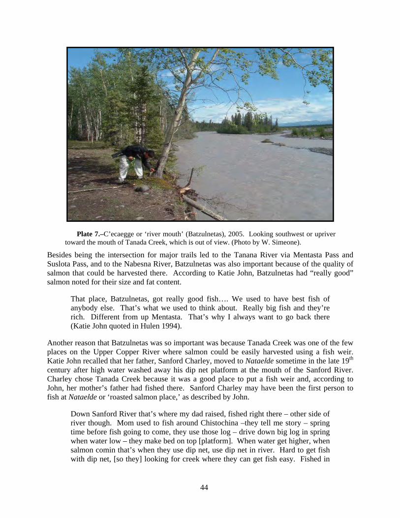
44
Plate 7.–C’ecaegge or ‘river mouth’ (Batzulnetas), 2005. Looking southwest or upriver toward the mouth of Tanada Creek, which is out of view. (Photo by W. Simeone).
Besides being the intersection for major trails led to the Tanana River via Mentasta Pass and Suslota Pass, and to the Nabesna River, Batzulnetas was also important because of the quality of salmon that could be harvested there. According to Katie John, Batzulnetas had “really good” salmon noted for their size and fat content.
That place, Batzulnetas, got really good fish…. We used to have best fish of anybody else. That’s what we used to think about. Really big fish and they’re rich. Different from up Mentasta. That’s why I always want to go back there (Katie John quoted in Hulen 1994).
Another reason that Batzulnetas was so important was because Tanada Creek was one of the few places on the Upper Copper River where salmon could be easily harvested using a fish weir. Katie John recalled that her father, Sanford Charley, moved to Nataełde sometime in the late 19th century after high water washed away his dip net platform at the mouth of the Sanford River. Charley chose Tanada Creek because it was a good place to put a fish weir and, according to John, her mother’s father had fished there. Sanford Charley may have been the first person to fish at Nataełde or ‘roasted salmon place,’ as described by John.
Down Sanford River that’s where my dad raised, fished right there – other side of river though. Mom used to fish around Chistochina –they tell me story – spring time before fish going to come, they use those log – drive down big log in spring when water low – they make bed on top [platform]. When water get higher, when salmon comin that’s when they use dip net, use dip net in river. Hard to get fish with dip net, [so they] looking for creek where they can get fish easy. Fished in

45
Copper River. That’s what my mother say – my Daddy and his uncles fixed up that place – sometimes when high water and wash out – sometimes they cannot fix that because of high water. They got hard time getting fish in river – can’t get fish in river – just that dip net they use. That’s why nobody fishing in that river – look for creek where creek come out and salmon go so they use a fish trap (K. John 2005).
Katie John recalled that her father always operated a fish trap at Tanada Creek,
My Daddy had always used a fish trap. My Daddy block up the creek [with a fish weir] and catch fish. Then he open it up [the weir] and let the fish go, then close it up, catch more fish, then open it, and let the fish go. Every year he do this. The fish always come back” (K. John 1999:16).
Then in the 1940s a federal game warden came to Batzulnetas and told Sanford Charley that he was no longer to use fish traps in Tanada Creek. Katie remembers that “now this warden tell him something, and my Daddy don’t understand. He feel bad. My daddy left Batzulnetas” (ibid.).
In recent interviews, Ahtna elders discussed what they know about salmon spawning in the upper tributaries of the Copper River (Kari 1986:190; Simeone and Kari 2002:24; Katie John 2005; Steven John 2005). On the upper Copper River, above the mouth of the Sanford River, the Ahtna have identified every known spawning area for Chinook and sockeye salmon. (see Figure 11 and Appendix A). The precise identification of these streams reflects Upper Ahtna fishing practices. Before the introduction of the fish wheel at the beginning of the 20th century, the Upper Ahtna preferred to fish on tributary streams using weirs and traps, rather than on the mainstem of the Copper River using dipnets. According to Ahtna elders, a number of the sites in Figure 12, such as the East Fork of the Chistochina River, Indian River, Suslota, and the Sanford River, were all locations where Ahtna once harvested salmon.
Many of the place names listed in Figure 11, such as ‘rough rock fish’ (no. 65), ‘flows straight fish’ (no. 61), ‘shallow lake fish’ (no. 84), and “trail goes on sand fish” (no. 88) describe the diversity of habitats where salmon are found.15 The Ahtna also recognized this diversity in the morphology of different salmon populations. Ahtna fishers could identify where salmon spawned by their physical characteristics such as size and body shape (Bell Joe n.d.; Katie John 2005). Katie John (2005) remembered that when the Batzulnetas fish reached the fish camps downriver people sent word to the upper villages that these fish were on their way. She said the old people “know by the look, know Batzulnetas salmon.” She went on to explain that Mentasta fish look like salmon but are a little different; she described them as round. Suslota fish are small. She also said those fish that spawn in Bear Valley (called Kolgiis Na’) are “just a little bigger than whitefish, those big whitefish” and are similar in appearance to those salmon that
15 Nataeł luugu, or ‘roasted salmon fish,’ are named after the place Nataełde (‘Roasted Salmon
Place’), which refers to fire-roasted salmon, a special salmon dish prepared by the men of the village (Reckord 1983a:203), but these fish are also referred to as “wide meat fish,” a reference to their girth.

46
Figure 11.–Upper Ahtna salmon fisheries.

47
spawn in Suslotina Creek (called Tsek’ohwtsedle). She also described sockeye that spawn in Copper Lake as having a hump. The ability of Ahtna fishers to identify where certain salmon spawned was noted by the biologist Seton Thompson in the 1930s (1964:44). Thompson wrote:
It is said that Suslota Lake supports a race of salmon considerably smaller in size than salmon bound for other tributaries, and natives at fish camps in the vicinity of Gakona, without hesitation segregate their catches into ‘Batzulnetas fish’ and ‘Suslota fish.’
Ahtna elder Fred Ewan (2005), who has lived in the village of Gulkana all of his life, described the Batzulnetas fish as “really fat, all grease, heavy.” He also said that the first run of salmon is weak because it fights a “big current.” The second run passes Gulkana either the last part of June or early July and lasts about 15 days. This is the best run because they are “bigger fish.” Elder Danny Ewan (2005), who has also lived in Gulkana much of his life, agreed that the Batzulnetas salmon pass by the village in late June or early July. During an interview conducted for this project in 2005, Katie John described the sequence of the arrival of salmon at Tanada Creek. The fish come in pulses and do not run all of the time.
[In] June two big hit come in and July same way, August same way – then no more….. [In] August another hit coming, [that is the] last one. Fish don’t run all of the time. Sometimes [for a] week no fish (K. John 2005).
Kathryn Martin (2005) said that according to her grandmother Katie John, the big Batzulnetas sockeye enter Tanada Creek in August. She recounted that National Park Service (NPS) personnel showed her grandmother photographs of different salmon and she was able to identify where each spawned. John asked why they had not shown her photos of the Batzulnetas fish? Martin said that her grandmother told NPS personnel,
That’s a last one. At the very end. She [Katie] say, it’s bigger, it’s fatter, and it looks little bit different. They were like, no, there’s no species like that. And, they kept that weir in late in the season and sure enough Batzulnetas fish hit. And the other thing though is that the elders down this way, they catch fish in their wheel, they know where those fish are going to spawn (Martin 2005).
ARCHIVAL SOURCES In 1921 fisheries agent Shirley Baker was sent to ascertain whether new regulations restricting the commercial fishery had increased the amount of salmon escaping into spawning grounds. One of the people Baker interviewed was Mr. Berail (Baker 1921:17), who had spent a number of years prospecting and traveling in Upper Ahtna territory. Berail’s testimony reflects Katie John’s recollections of the abundance of dead spawned out salmon around Copper and Tanada lakes. Berail told Baker:
I remember several years ago when the lakes and creeks emptying into the head of the Copper River were thick with salmon. In fact, I have seen the lakes just covered in places with floating dead spawned salmon, and the shores of the lakes were also strewn with dead fish (ibid.).

48
Baker said that all the people he interviewed agreed that the salmon, which entered the river early in the season, spawned in the lakes and streams at the head of the Copper River. One person was “positive” that the majority of the first run “goes straight for the headwaters of that river and enters the four head lakes…. the Bartzulneta [sic], Mantasta [sic] (Plate 8) and Susloto Lakes [sic], and Copper River Lake better known as Tanada Lake” (Baker1921:3). In addition, most local residents believed that these early salmon were smaller than those fish headed to other
Plate 8.–Mentasta Lake, one-half mile east of Mentasta Village, circa 1900. (Photo by F.W. Schrader).
tributaries of the Copper River. Chief McKinley George of Copper Center told Baker “the first run ascends to the head lakes…”and “…the individual fish of this run are smaller in size than the red salmon that ascend the lower tributaries flowing into the Copper River”(ibid.:10). Baker (ibid.) concludes that there are “several distinct salmon runs in the Copper River, as there are seven or more tributary rivers to the Copper which are good propagating streams. Each one of these streams likely has its individual run of fish.” He goes on to say that,
it is also evident that the individual red salmon of the first run appearing at the mouth of the Copper River is a little smaller fish than the later runs, taking into consideration the number of fish required per case16 during the first part of the season as compared with the number required per case when the more advance run appears.
16 Baker is talking about the packing cases used by the salmon cannery to pack cans of salmon.

49
In 1932 federal managers were still learning about the runs of salmon in the Copper River. After hearing from a local resident that the salmon first appeared at Copper Center on May 27 but that harvests were small until July 31, when the number of fish increased, Bureau of Fisheries Agent Hawkins (1932:121-122) wrote:
it appears that there is a later run of red salmon to the spawning ground in the Copper River region other than the large run appearing earlier in the year and being fished commercially.
Hawkins thought the later run entered the river during the later part of July.
SCIENTIFIC ACCOUNTS OF HEADWATERS SALMON STOCKS Aerial surveys of salmon in Tanada Lake and Tanada Creek began in 1940 (Thompson 1964). Although aerial survey escapement estimates are highly variable, they do provide an index of relative run strength from year to year and since the 1980s, the surveys indicate a downward trend in the Tanada Lake sockeye salmon population (Veach 2003:15). A weir operated by the Alaska Department of Fish and Game in 1975, 1978, 1979, and 1997 provides only an index of relative run strength, since high water events often washed the weir out (Raeder et al. 1998). In 1998 the National Park Service began operating a weir on Tanada Creek located about 920 meters upstream from the Copper River and approximately 160 meters downstream of the Batzulnetas village site. Between 1998 and 2005 escapement in Tanada Creek has fluctuated substantially from a 28,992 sockeye in 1998 to 1,660 sockeye in 2001 (Veach and McCormick 2005:21).
The Copper River is a “mixed stock fishery.” Biologists define a stock as a population of salmon that spawn in a specific location. For example, Tanada Lake supports two stocks of sockeye salmon, one that spawns at the entrance to the lake and another that spawns in the lake (Roberson 1987). Stocks vary in population size, depending on how stable the spawning environment is. Because Upper Copper River stocks spawn at the extreme edge of the watershed they vary in abundance more than salmon that spawn in tributaries on the middle Copper River (T. Taube personal communication). This variability makes upriver stocks susceptible to overharvesting, but biologists do not think these stocks are in decline or are a “stock of concern.” The state of Alaska defines a “stock of concern” in the Sustainable Salmon Policy (5ACC 39.222) as a stock of salmon for which there is a yield concern, a management concern or a conservation concern. The state of Alaska has a formal process for determining “stocks of concern” and upper Copper River stocks have not reached this level.
The Upper Copper River provides a diversity of spawning habitats, some of which are more stable than others. Beach and lake spawning tend to be stable spawning environments, as do large rivers, rivers between lakes, and lake outlets (Roberson 2005). Tanada Lake, for example, provides stable spawning habitat; the fish spawn in lagoons located in the outlet of the lake where spring water percolates up from the bottom, though on occasion the outlet goes dry and the salmon have to go somewhere else to spawn. In comparison, small, fast moving streams like Bone Creek are much less stable with the result that salmon populations in these streams are highly variable. Roberson speculates that Bone Creek and Mentasta Lake may have changed in the 1970s (Roberson 2005). Because it is shallow there may not be enough oxygen for the rearing of young salmon. Roberson’s observations substantiate many of Katie John’s observations and, in fact, Mentasta residents have identified changes in the lake caused by the re-
50
routing of Station Creek. According to village residents, the Army Corps of Engineers rerouted Station Creek in the 1950s to accommodate the construction of the highway to Tok. The creek used to flow east in the direction of the highway and then into Minerals Lake and the Tok River drainages; it now flows into Mentasta Lake and is causing parts of the lake to silt up (see Chapter 5 for further discussion of Station Creek).
Scientists now recognize that the homing of salmon to natal streams for reproduction facilitates the development of numerous genetically distinct populations (Taylor 1991). As a result, salmon populations frequently differ in morphological, migratory, and life-history traits, and these traits are believed to have evolved just over the last 8,000 to 15,000 years (Quinn 2005). In other words, adaptation to different pawning habitats is reflected in the physical characteristics of different salmon stocks. For example, salmon like the nataeł luugu’ (‘roasted salmon fish’), or dzahnii luuggu’ (Copper Lake Fish), that spawn in large lakes, where there is little predation, are usually larger, with deeper bodies and exaggerated humps and jaws, compared to sockeye that spawn in more constricted environments where there is high predation, such as Suslota Creek (cf. Quinn et al. 2001; Hilborn et al. 2003:6565).
Salmon diversity on the Upper Copper River is currently being investigated by researchers from ADF&G. Using radio telemetry, scientists from ADF&G have located 12 different Chinook stocks that spawn in tributaries of the Copper River above the Sanford River (Savereide and Evenson 2002:33), all of which have been previously identified by the Ahtna. Using genetic sampling techniques, ADF&G scientists have also learned that there are at least five separate genetic lineages of Chinook salmon that spawn in tributaries of the Copper River, and populations that spawn in the Upper Copper River (i.e. above the mouth of the Sanford River) are “particularly genetically divergent” (Seeb et al. 2006:10).
Scientific data and local oral tradition concur that salmon stocks migrating to the headwaters of the Copper River enter the river early in the season (Merritt and Roberson 1986). The earliest recorded arrival of salmon at Tanada Creek is June 3, 1885 (Allen 1887). Steven John (2005), who grew up at Batzulnetas in the 1920s and 1930s, said the annual run of salmon was very regular and that the fish usually arrived at Batzulnetas on June 10 and at Mentasta on June 15, and people began fishing at that time. ADF&G has recorded the earliest arrival on June 4, 1994 (Raeder et al. 1998:16), but the state’s records only go back to 1978. According to the National Park Service, which has operated a weir on Tanada Creek since 1998, sockeye salmon have been observed at the weir between the last week of June, and the middle of July, and the average median run date occurs on July 17 (Veach and McCormick 2005:22). However, because of limited data it is not possible for biologists to determine a median run date for Tanada Lake sockeye salmon (ibid.).
According to Roberson (2005), salmon stocks reach the upper Copper River during the early to middle part of June. On the upper Slana River and Fish Creek, the peak spawning takes place about July 20th, so people harvest fish prior to that date. Salmon in the Suslota system spawn in early August. Tanada Lake salmon spawn in the middle of August.
Roberson (2005) offered one explanation for the “missing’ Batzulnetas salmon. Commercial fishermen target larger fish because they are more valuable and they use nets with large mesh that allow smaller salmon to escape. Roberson speculated that the large Tanada Lake sockeye might have been taken in larger numbers than the smaller Suslota Lake sockeye that can get through the nets.

51
SALMON HARVESTS AT THE HEADWATERS When comparing their recollections of salmon harvests in the 1920s and 1930s to more recent catches Ahtna elders see a decline in the abundance of salmon stocks migrating to the headwaters of the Copper River. According to Katie John (n.d. c), when her parents fished at Batzulnetas in the 1920s and 1930s, they harvested and dried several thousand salmon, and both John and Gene Henry estimate that their respective families harvested a total of about 5,000 fish annually.
Systematic harvest records for the upper Copper River do not exist prior statehood. The earliest record we have of salmon harvests near the headwaters is a photograph (Plate 9) taken at Mentasta in 1903 which shows large numbers of salmon hanging on racks and a fish weir across
Plate 9.–Mentasta in 1903. In the left foreground is a fish weir across Mentasta Creek. In
the right background is a large salmon drying rack. (Photo courtesy of Geoff Bleakley).
Mentasta Creek. Between 1914 and 1920, when wardens from the U.S. Bureau of Fisheries investigated escapement and harvests on the Copper River above Chitina, they never visited Batzulnetas or Mentasta, but relied on second-hand information. They were told that, prior to 1915, salmon runs to the headwaters had been “light,” and people were forced to extend their hunting activities to make up for the lack of fish (Lyman 1916a). Alfred M. Bailey (1919), a wildlife biologist working for the U.S. Fish and Wildlife Service, visited Batzulnetas in the winter of 1919 and was told by the local residents that they had harvested all the salmon they needed, but that was the first time they were able to do so in years. In 1921, Baker (1921:17) was told that the Ahtna living at the headwaters had harvested between 14,000 and 15,000 salmon. Thompson (1964:42-44) reported that the runs on the upper river failed in 1931 but that escapement in 1933 appeared to have improved, based on the catches of fish wheels owned by Lawrence Dewitt, who fished at Slana, and Batzulnetas Billy. Batzulnetas Billy reported harvesting 244 salmon in July and 733 fish in August of 1933. An undated photograph of Batzulnetas Billy’s fish camp appears in Plate 10. Another photograph, taken in the early 1940s at Mentasta, shows several hundred salmon hanging on racks (Plate 11).

52
Plate 10.–Undated photo of Batzulnetas Billy’s fish camp at the mouth of Tanada Creek (Photo courtesy of Ahtna Inc).
Plate 11.–Salmon drying on racks at Mentasta, early 1940s. (Photo by Cleo B. McMahan, courtesy of Sally McMahan Pollen).

53
FISHING AT BATZULNETAS, 1987 TO 2005
In 1964 the state closed all tributaries of the Copper River and the area around Batzulnetas to subsistence fishing. In the late 1980s Katie John and Doris Charles, who was also raised at Batzulnetas, won the right to fish at Batzulnetas. Since 1987 the residents of Mentasta have been allowed to fish at Batzulnetas, but they claim that for between 1987 and 2006 have not been able to meet their subsistence needs for salmon. Harvest records show that in 1987 the Ahtna harvested 22 sockeye salmon at Batzulnetas, but between 1988 and 1992 no one fished there, and there were no permits issued in 1996 or 2000. For the years 1993 to 2004 (excluding 1996 and
Plate 12.–C’ecaegge or ‘river mouth.’ Tanada Creek at Batzulnetas, 2002. The fish camp is to the left in the picture, the Copper River to the right. (Photo by W. Simeone).
2000) an average of less than two permits per year were issued with an average annual harvest of 285 fish, the largest reported harvest was 997 salmon in 1994 (Veach and McCormick 2005). No fishing has taken place since 2005 when high water washed away the fish wheel.
Kathryn Martin (2005) described some of the difficulties connected with fishing at Batzulnetas. One problem is that the bank between the regulatory markers is very steep and it is hard to move the wheel to a better spot (Plate 12). In addition, all of the property within the Batzulnetas district is privately owned, which creates problems for moving the fish wheel. Accessibility is also a problem. The site is about three miles off the Nabesna Road down a deeply rutted and unpaved trail, and during the spring four wheelers often get stuck. Mentasta residents would like to improve the trail, but they are afraid, because the trail crosses public lands, that improving it would open up the site to the public and create additional problems.
Another resident of Mentasta, who for the last twelve years was the principal fisher at Batzulnetas, described how high water in 2005 destroyed his fish wheel that he had left at Batzulnetas to avoid the task of hauling it to land and down the rough three-mile path to a gravel road.
This season I didn’t do it [fish] because my raft and wheel got torn up down river and I had over a thousand dollars invested in it…it’s a…job more than it is anything because we live here [Mentasta] and it's like twenty-five miles and then

54
you got to drive in with a four-wheeler so it’s an everyday thing from here to there. I did it probably close to twelve years putting in a fish-wheel and letting it run all summer. And usually when I’m down there I’m camping out too... (quoted in McGaffey 2005).
Fishing at Batzulnetas is expensive both in terms of money and time. To maintain the wheel and haul fish from the site requires a four-wheel drive pickup truck or four-wheeler. Trucks require insurance, license, and registration, and monthly car payments. The round trip between Mentasta and Batzulnetas is 60 miles. To obtain the required equipment and money for fuel requires a job that cuts into fishing time or, depending on the type of employment, eliminates fishing altogether.
SUMMARY The goal of this project is to triangulate local and scientific knowledge in order to gain a better understanding of the status of salmon on the Copper River. In this chapter we focused on salmon that spawn in tributaries of the Copper River located above the mouth of the Sanford River. Sources agree that salmon populations on the Upper Copper River are complex and divergent from other salmon in the water shed. This complexity may be the result of adaptation to the variety of spawning habitats found on the Upper Copper River, and reflected in Ahtna place names. Diversity is revealed in genetic studies that show that Chinook salmon from the Upper Copper River are “particularly genetically divergent” from other Copper River Chinook salmon (Seeb et al. 2006:10), in the salmon morphology described by Ahtna elders, and in timing of the annual migration (Merritt and Roberson 1986; Savereide and Evenson 2002).
In the Ahtna tradition, the fishery at Batzulnetas on Tanada Creek was the most important salmon fishery on the Upper Copper River and, according to Ahtna elder Katie John, Tanada Lake produced the nataeł luugu, a particularly large sockeye salmon. Basing her opinion on years of observation, John believes these salmon, as well as other salmon on the Upper Copper River, are in jeopardy from human use, environmental pollution, and regulation. Resource managers, relying on aerial surveys, radio telemetry, and weir counts, believe that these same salmon populations are not in jeopardy but subject to considerable natural variation. John’s observations lack the precision of modern technology or quantitative analysis, but biologists have no long-term knowledge of individual salmon stocks and cannot, for example, determine what is a healthy or natural escapement for streams like Tanada Creek (Veach 2003:15).
In summary, if salmon populations on the Upper Copper River are in jeopardy either because of changes in the environment or because of overharvesting, then genetic diversity is lost and the sustainability of the fishery is threatened (cf. Fraser et al. 2006). That is what Katie John is pointing too and seems to be alarmed about. She is also saying that salmon are much more sensitive to environmental change than we think they are.

55
CHAPTER 5. ENVIRONMENTAL CHANGE INTRODUCTION In this chapter we describe numerous multi-scaled environmental changes that are occurring within the Copper River Basin. We also describe the cumulative effects of these changes on the salmon fisheries and Ahtna culture. In this chapter we provide an Ahtna perspective of these changes and the degree to which these changes are affecting the Copper River Basin ecosystems. Each key respondent cited in this chapter has knowledge of the Copper River ecosystems gained through years of living on the banks of the Copper River and its tributaries, and through hearing oral histories passed down from generation to generation. This chapter is organized around topics familiar to Western scientists with the supporting evidence primarily from the Ahtna.
Whether accelerated by human activity or a natural shift in the climate, the worldwide climate is warming at a rapid rate (Arendt et al. 2002). Alaska has experienced the greatest change in temperature of any state in the United States, with warming occurring since the 1960s (ibid.). Annual average temperatures across Alaska have increased 1.8°F per decade over the last three decades, and winter warming has increased as much as 3°F per decade (ibid.).
The world’s indigenous communities are well aware of these changes. Indigenous communities have compelling insights and observations about changes in the weather and changes in the behavior of animals. For example, many residents of Alaska Native and Canadian Inuit communities have observed that within a single generation, they are no longer able to predict weather patterns as their elders taught them because of greater variability and severity of the weather (Krupnik and Jolly 2002). Loss of the ability to predict weather patterns is not due to a lack of transmitting knowledge, but rather to new patterns of weather that have not been experienced before.
Ahtna observations not only mirror many observations made by researchers investigating climate change, they also provide first-hand qualitative documentation of the effects of climate change on one geographical area of the world’s ecosystems. Climate change is having an impact on Ahtna life and culture. Communities within the Copper River Basin are reporting changes in the stock returns, fish behavior, and health of the salmon returning to the tributaries of the Copper River. Most of these reports are anecdotal and the absence of hard data underscores the urgency of improving the research and management of the salmon fisheries.
IMPACTS ON THE ENVIRONMENT The Ahtna say that global climate change and human behavior are having a significant impact on the Copper River Basin. The Ahtna base these assertions upon thousands of years of experience in the Copper River Basin (as evidenced through the archaeological record, oral histories, and present-day observations). An attribute of subsistence cultures is the ability to live with scarcity and change. In the past, the Ahtna learned to cope with variability and change by using knowledge that was passed down from generation to generation. But as the speed of change has increased, propelled by factors such as global climate change and industrial pollution, they are losing the ability to use their knowledge to predict and adapt to the changes in the Copper River ecosystems.

56
COMMUNITY-BASED ENVIRONMENTAL ASSESSMENT: CLIMATE CHANGE AND THE COPPER RIVER FISHERIES Throughout the 2004-2006 field seasons, seven themes of environmental change ran constant through the community workshops, key respondent interviews, public testimonies, and public presentations. These themes are:
1. Annual seasons.
2. Weather
3. Permafrost.
4. Fish and Wildlife.
5. Vegetation.
6. Erosion.
7. Pollution.
The information gathered in interviews and public testimony represents a community based assessment of climate change and human-influenced change in this region (Krupnik and Jolly 2002.) Table 5 illustrates different types of environmental change as observed by the Ahtna.
Affects of Climate Change Changes relating to variations in the annual seasons dominate Ahtna observations. These include changes in the coming and going of the seasons, lack of river ice, increased water volume and velocity, earlier seasonal high water events, increased glacial melt, and an increased frequency of forest fires.
As discussed in Chapter 2, the natural cycles of the seasons – spring, summer, autumn, winter – shaped when and where resources were used and harvested. In the past, when the ice in the river broke up, people moved from their winter camps to the summer fishing camps. People usually fished until about the middle of July, but sometimes they quit fishing earlier because, by that time, all the salmon needed for the winter were caught, dried and put up for winter storage. Upon harvesting and drying enough salmon for the winter months, the people moved upland to pick berries, hunt moose, caribou and sheep.
Many respondents observed changes in the seasons based on salmon run timing and run strength. In the past, mid-river fishermen in the Copper Center area used to put their fish wheels in and catch what they needed in early June and, as soon as enough salmon was harvested for the entire year, the wheels were removed (Jerue 2005). Angus Dewitt (2005) recalls the best tasting salmon arrived after June 1st and that they were undesirable (“bad”) after mid-June. Near the Copper River headwaters, fishers stopped fishing in the middle of August,
which was when the salmon turned red. Before that they were silvery…In July and August, the salmon smolt washed down Tanada Creek and the children caught them, cooked them, and ate them (S. John 2005).

57
Table 5.–Examples of Copper River Basin environmental changes observed by Ahtna residents.
Observation gathered in interviews between 2004 and 2006
1. Shorter, warmer winters
2. Longer, warmer summers
3. River stays open in the winter
4. Glaciers are melting faster
5. Increased water volume and velocity
6. Increased water temperatures
7. Change in timing of high water events
8. Increased annual rainfall
9. Decreased annual snowfall
10. More thunder in the summer
11. More forest fires
12. Tazlina Lake ice dam breaks earlier in the season
13. Increased numbers of suckers in Mentasta Creek and lake
14. Decrease in number of song birds
15. Increased number of wasps
16. Overall size of fish is smaller
17. Discrete stocks of salmon are “missing” or depleted
18. Salmon are holding in deep pools within the river
19. Salmon health is decreasing
20. Lakes are drying up
21. Water table is dropping
22. Military dump sites and barrels
23. Railroad oil spills
24. Human waste on the banks of the Copper River
25. Re-routing of Station Creek
26. Deceased access to fishing sites
27. Landslide at O’Brien Creek
28. Increased jet boat traffic
29. Lakes are drying up
30. Water table is dropping

58
Today, some of Ahtna report that they are having trouble harvesting fish in a similar time frame. In part they say this is due to reduction of stocks returning to the headwaters of the Copper River and also due to a shift in run timing. Not only are the Ahtna having to fish later in the season to fill their caches, but they are also reporting the current regulations restrict them from catching the first runs of salmon up the Copper River (federal regulations allow Copper River subsistence fishing to start fishing in May and state regulations allow subsistence fishers to start on June 1).
Many residents reported a greater number of hot days in the summer as compared to the past. When drying salmon it could be assumed that an increase in summer temperatures would be beneficial to the Ahtna. However, it is more important to keep flies off the drying fish in order to prevent the flies from laying eggs on the salmon. The proliferation, survival and habitat range of flies increase with warm weather; avoiding flies when drying salmon have become more of a challenge today than in the past.
Moreover, as the days and years grow warmer, the Ahtna are also experiencing greater difficulty in catching fish. While dipnetting at her family’s traditional fishing site, Pauly Jerue (2005) noted that during stretches of hot days, the salmon move into deeper water where they are harder to catch. In the past, Jerue’s father instructed them to dipnet when it was raining because the fish tended to be easier to catch. Jerue speculates that as the climate warms and the shallow water closer to the banks warms the salmon move or stay in deeper water where it is cooler but harder for fishers to catch them (ibid).
The Athna also observed an increase in annual precipitation. Ruby Sinyon of Chistochina said that the last few years there has been a lot rain and thunder (Ramona Justin 2005). This is very different than the past, and an observation by Lt. Abercrombie during his 1898 expedition to the Copper River Basin helps illustrate this degree of change,
At Taral…the rains during our travels in the region were very light. The habits of the natives, the fact that this is the only place in the territory where salmon are cured by sun alone, as far as I know, and the amount of water discharged by the Copper River, all tend to prove that the rain king seldom invades this valley in force (Abercrombie 1900:165).
With an increase in the annual rainfall, the Ahtna are struggling to preserve salmon through the traditional method of drying them on fish racks, since for drying salmon the weather must be dry with a low relative humidity or else the salmon will rot. In addition to an increase in the summer rainfall, a number of respondents are observing a decrease in winter snowfall. Pauly Jerue (2005) notes, “[It’s] weird going to our cabin at Kenny Lake and not having to shovel all winter.”
The Ahtna use a number of other indicators to predict the run timing and strength of the salmon populations. From changes in the spring migration patterns of specific bird species, to changes in the timing of insect emergence, to the melting of snow in the mountain valleys, the Ahtna fear that changes in their indicators could signal more changes in run timing and strength. For example, if the spring snow melt in the mountains happens earlier every year, the Ahtna are concerned that this could be signaling a change in the salmon runs to earlier in the year. According to Katie John you could

59
Look at certain place on mountain. When salmon headed to lake, the snow right in the middle will melt. That’s true too; I use to check it all the time. [If the snow melts] up the point, mean hardly no salmon coming (2005).
Consistent with a decrease in the annual snowfall, the glaciers in the Copper River Basin are melting at a rate faster than ever before. This is particularly significant because glaciers were featured so prominently in explorers’ accounts of the Copper River Basin. Of particular significance was the portion of the lower Copper River flowing between Miles and Child’s Glaciers. According to the Ahtna, the Copper River had once run under the glacier that filled the valley with ice (Abercrombie 1900). The Russian F.P. Wrangell described the passage of the river through the mountains,
whose canyons contain eternal ice; it [the river] undermines these masses of ice, which break off in great chunks and are hurled with a mighty roar into the river, so that many fish are tossed onto the river bank; ice sometimes piles up in places where the river narrows, causing floods and making any journey by boat into these regions dangerous if not impossible (Wrangell 1980:82).
The American explorer, Lt. Abercrombie, made two trips up the Copper River in 1884 and again in 1898. On his first trip he described the river as washing the face of Miles Glacier as great chunks of ice broke off and sailed downriver and, sometimes, completely blocking the flow of the river. By 1898, the glacier had receded five to six miles and the river channel was very much wider and the current less violent. In that interval, Miles Lake had formed. Child’s Glacier had also receded, leaving a beach some 500 or 600 yards wide, but adding a succession of very “boisterous rapids” (Abercrombie 1900:572).
Katie John describes a similar condition of the river when asked about past river obstructions,
Sometimes down at Chitina – down river there was waterfall – fish cannot go up river. Story – only trouble I know. Long time ago people go down with boat when they get close to cliff they take out boat and go around – waterfall between Chitina and Cordova. Never hear anyone talk about that anymore. But I know when people use moose skin boat they have to around the waterfall (K. John 2005).
Then, in 2005, Pauly Jerue explained how she has noticed Tazlina glacier reducing in size,
The glacier, I notice that when I drive back and forth and I always see that lake pretty full up there, more than usual. It used to be that we didn’t see it too much as we would see the Tazlina Glacier because we drive up and down the road all the time. We drove up here since the 70s, 1970, we have been coming up and down that highway a lot. At Tazlina, we used to slow down in that area so you can see the glacier. Now you don’t see the glacier, as you see the lake, you can actually see the lake from the highway. Tazlina River, I don’t remember it running this high, this last few years. Occasionally, they had high water and flooding, but I don’t recall it being high almost continually.
60
Consistent with melting glaciers, Pauly Jerue (2005) has also noted changes in the water volume and velocity of the Copper River. She explains these as a result of increased rainfall in the Copper River Basin.
Water has changed a lot. I could just tell through the summer, my observations of the Copper River. When we are fishing out there, on a nice sunny day, the water would, we could look up river and, if it is raining up that way, and really black and stuff, we can figure we have about one hour’s worth of fishing before the, we could see the water actually rising. You can feel it come up and then, all of the sudden, it’s lapping into our pants, from the rain up in that area. It’s weird cause it almost feels like a tide, you can actually feel the water coming in; it gets a little more rough.
Furthermore, as water volume and velocity increase, natural deviations in the river channel become exacerbated, thus making the use of a fish wheel more difficult. These changes are also evident at Copper Center.
The water comes so swift that it stays pretty much in the same area. As long as I can remember, the river has kind of stayed the same, the channels in this area here. In the last few years is when I have noticed a big change of it; actually moving. Where Pete Ewan used to have his fish wheel, down here that used to be a fish camp there. They had a wheel here, and that water, I don’t know how many years, it doesn’t come up there, it’s changed onto the other side and the area on this side has overgrown and has trees on it, and nobody can fish there (Jerue 2005).
Changes in Fish and Wildlife As the environment of the Copper Basin changes, the Ahtna are also observing changes in the fish and wildlife. They include the insect populations, freshwater fish populations, and an overall reduction in the size of the salmon returning to the Copper River. In addition, there is the absence or depletion of discrete stocks of salmon returning to the headwaters (see chapter 4) and decrease in the overall health of the salmon.
In the summers of 2004 and 2005, residents of Mentasta, Chistochina, and Copper Center observed an increase in the wasp and bee populations. Longer, warmer summers coupled with shorter, milder winters contribute to the proliferation and over-winter survival of insects. Increases in wasp and bee populations impact the Ahtna method of drying salmon. Field notes from de Laguna and McClellan’s 1968 field season illustrate the damage wasps can cause to drying salmon,
{Q}Kings still running?
{MJ} No. I don’t think so. Xai lu.qE’ [silver salmon] – September month, he coming late. Can’t hang fish no more. DjindjIdi [ts'endziidi ts'ae'i, wasp] eat it up.
Tony Jackson had complained of the same thing and when we had gone down to his fish camp, we dared not approach the racks because of the wasps. The appearance of wasps that eat all the fish would explain why the people used to go into the mountains to hunt in mid-summer as soon as the wasps became numerous.

61
One benefit of warmer temperatures is the decrease in the number of mosquitoes related to a decrease in the size and quantity of area lakes, ponds, and wetlands, which are necessary for mosquito propagation. Additionally, the mosquito populations increase as the ambient air temperatures do a certain threshold is reached wherein the mosquito populations significantly drop (Thorpe et al. 2002). This threshold is repeatedly crossed as there are numerous reports of a decline in mosquito populations (ibid).
As the water of Mentasta Lake becomes shallower and warmer, local residents are concerned about the impacts on the salmon spawning. Their reasons are two-fold. First, as the lake becomes shallower, more aqueous weeds grow resulting in a reduction in salmon spawning habitat and a decrease in oxygen available within the lake. As the dissolved oxygen levels decrease in the lake, the oxygen available to the eggs in the redds and the rearing young salmon also decreases.
Second, changes to the lake are providing more favorable conditions for sucker populations. A number of the residents of Mentasta Lake are concerned that this will be detrimental to salmon because suckers are known to eat salmon eggs.
On numerous occasions, the Ahtna have reported a loss of a discrete stock of salmon only known to spawn in Tanada Lake, “Batzulnetas – never seen Batzulnetas fish – pretty near same size as king salmon – when dried fish were very wide (Katie John 2005). Ahtna knowledge holds that the salmon destined for the headwaters of the Copper River, or rather the fish traveling the furthest, return to the river first. The exact reason for the loss of the Batzulnetas stock is unknown. It is speculated that this early run of salmon was intercepted by the commercial and personal use fisheries (Roberson 2005; see chapter 4).
The Ahtna are also observing salmon in poor health. Up and down the Copper River, residents report changes in the taste and texture, open sores on the flesh of the salmon, lighter or gray-ish colored flesh, reduction in body fat, and a reduction in the overall size of the salmon.
Locals are also noticing sores, net marks (from commercial and personal use dip netting), and growth of fungus on the flesh of the fish (Pennington 2005; Pennington 2006; Finnestand 2006; Marshall 2006). They relate the change in salmon health to increases in water temperatures.
In recent years, Ruby Sinyon of Chistochina has noticed that the salmon seem skinnier and smaller than the runs of the past. For instance, in the summer of 2005, she dried the first run of sockeye, as she normally does. When she put her fish away, there was very little oil in the meat. Also, while processing her fish, she noted the flesh was very soft and hard to fillet (Ramona Justin 2005). Mae Marshall (2005) of Tazlina also noticed a change in the salmon,
I get so disappointed looking at them now. When you try to make strips out of them, the bellies are just so thin. Even the king salmon used to be so thick. We used to have a smokehouse, the sockeyes use to fill them up, and they had a good thick meat on them. Now days they just curl up. The salmon do not taste as good as it use to. The further you come up this way, it gets more poorer.
Lena Charley of Chistochina also commented that when she was a little girl, the salmon were fat and oily and now the salmon are “skinny and lacking oil in the head” (Ramona Justin 2005). She recalls the salmon used to be “large and fat” (ibid). These morphological changes make it difficult to dry the salmon; some dry too quickly (Lena Charley in Ramona Justin 2005) or “they dry as hard as a bone” (Mae Marshall 2005).

62
Permafrost and Wildfires Throughout the Copper River Basin, residents are observing the melting and disappearance of permafrost as an indicator of environmental change. Specifically, local residents note a reduction in the size and quantity of Basin lakes and in the water table dropping. Pauly Jerue (2005) of Copper Center states,
Dad tried to put a well in there one year and he hit the permafrost. He got as far as he could. Then we built there in 1973-74, when we dug out for an outhouse, we could have just kept digging and we did not hit permafrost. Mom had a hole dug out for the refrigeration because there was permafrost, she would put a board over it. Now, it’s all melted.
When permafrost melts, the water table drops, similar in effect to a bath tube drain. Laura Hancock, who lives at Twin Lakes along the Nabesna Road, (2005) has observed a drop in the water table in and around the Twin Lakes area. As the permafrost melts and the water table drops, rearing habitat for sockeye salmon could be reduced within the Copper River Basin.
The Copper River Basin permafrost was formed during the Little Ice Age and has remained relatively stable in the Basin’s neutral climate (a climate that remains relatively stable throughout time), because it has been protected by other ecological components, such as mosses, peat, and other vegetation (Shur and Jorgenson 2004). Removal of these protective covers, be it by natural or human disturbance, typically leads to permafrost degradation. This, coupled with climate change scenarios that predict at least a 3˚C increase in mean annual temperature in the next twenty years, means that the permafrost of the Copper River Basin will not recover and will continue to degrade (ibid).
Fires contribute to the mosaic of landscapes within the Copper River Basin by varying the degree to which the natural progression of plant colonization in an area after a great disturbance (i.e., forest fires, glaciations). In the past, the Ahtna initiated small scale fires to fertilize the local vegetation and increase the nutritional value of the fodder upon which the local animals feed. Although the Ahtna set small fires, according to Katie John, there were fewer naturally occurring fires in the past because the temperatures were colder, there was more precipitation and there was more moisture in the ground and soil,
You know, Alaska, long time ago, never see forest fires – water under the ground. Dig those moss, get it out big one, I use to know just wet. No forest fire long time ago, but all those things was change, now coming dry. My daddy used to take of his animal out there for the eat. Those mound, burn those open place. He burn those open place, near creek, burn muskrat, when hunt muskrat, over-burn everything by the lake, all new one come back up. That’s why they keep animal fat. Now start forest fire, even blueberries grow back more than before, really big too, new leaf. That’s the way they used to do, burn everything – that’s the way to keep moose fat and caribou (Katie John 2005).
Forest fires are one the biggest contributors to permafrost degradation in the Copper River Basin. Between 1897 and 1915, the tempo of fire destruction greatly increased as prospectors, miners, and railroad and road construction crews came to the area. During this period numerous fires were started to clear away old forest growth, produce good fuel wood, combat mosquitoes, assist in herding wildlife for hunting purposes, promote the growth of grasses for wildlife and

63
livestock, and to clear land (Lutz 1959). In an 1898 account of passing over the Valdez Glacier to the Klutina drainage, Lt. Abercrombie (1900:570) describes the effect of the fires,
At the head of each of these [valleys] is a small glacier, from which issues a stream of greater or less magnitude, depending on the sun’s rays, which are exceedingly fierce on the glaciers and give a tremendous flow of water on the afternoons of clear days. Just above the head of Lake Abercrombie the streams united and empty into that lake through many channels. I hear noticed that the climate in this region must be rapidly changing. I also noticed that in many places the moss was dead and dry as punk, so that when a fire was started for camping purposes it was impossible to put out. The small, dry roots of the moss would smolder for days and weeks, until a favorable opportunity would fan it into a blaze. I noticed there was quite a mound of petals under each spruce tree, the branches coming close to the ground. When a fire had eaten its way to one of these trees through the moss, the petals would ignite, and the fire, rushing up the tree with a roar, would create a flame 150 feet high. This would send forth a shower of sparks that would start thousands of additional fires, each to repeat the operations of the first. The entire valley seemed to be on fire, which made traveling through the timber very dangerous, as the falling trees were liable to injure man or beast, if they did not stampede the entire pack train.
In many places the moss is dead and gray as punk. Mounds of petals below each spruce tree and danger of fire because the ground is so dry. In fact, there are so many fires burning it made traveling difficult.
Wildfires that burn into or through the entire organic layer of soil covering permafrost could cause increased siltation and run-off into the streams and tributaries of the Copper River Basin. Adverse impacts to the Basin’s fisheries could result from increases in stream flow, sediment, and debris. Moreover, water temperatures could rise resulting from increased exposure of the stream surface to direct sunlight after the riparian vegetation is destroyed by the fires. Fire can also increase landslide potential up to five years after the event due to the decay of anchoring root systems (Meehan 1991; U.S. Bureau of Land Management (BLM) 1999). Upon discovering a landslide on Mentasta Lake, Fred Moffit (1929), a geologist and early explorer into the Copper River Basin, noted,
The camp in which we are camped is called Station Creek and this summer for the first time it flows west into Mentasta Lake. This is due to a large quantity of mud and gravel brought down by high water this spring and summer. Both sides of the Station Creek Valley at the old Telegraph station are now in ruins…
The high water of this year has caused many landslides and the streams have brought down much gravel and silt. The north slope of Mentasta Pass, between Station Creek and [Mentasta] Lake has been burned within a year or two, destroying much fine timber and causing many landslides. Station Cr. [sic] is now diverted to Mentasta Lake. The outlet of Mentasta Lake is now swimming water and the low ground adjacent is covered with a new deposit of mud extending through the willows many yards from the stream. The conditions there is so changed and bad that it seemed best to cut the new trail. The Mentasta Indian village was flooded and they are rebuilding on higher ground (Moffit 1929).

64
Vegetation Those Ahtna interviewed for this project have noticing changes in the area’s vegetation. Many have observe an increased rate of plant succession, altered plant species composition, and a decrease in forage vegetation availability for caribou and sheep. Normally, as an ecosystem matures, the species of organisms found changes until stasis is reached and a stable community is formed; this process is called natural succession. Global climate change appears to be speeding up the natural succession of vegetation in the arctic regions. Pauly Jerue (2005), a past resident of Kenny Lake, has noticed changes there:
That used to be a tree area. I drove down to Kenny Lake. One of the land marks in that area, in [the] Indian [language], was called the muskrat place. It is all dried up now and [they are] farming over it. I think it was because of the fire also. It was beautiful; you could see everything and walk anywhere. Now there is so much muck tree and browse. We used to walk with Grandma. There used to be low bush, moss berries everywhere…We used to walk back there. Now you cannot even find the trails.
A comparison of photographs taken of Batzulnetas in 1900 and 2005 (see Plates 13 and 14) illustrates an increase in shrub abundance and the extent and density of spruce trees along the tree line. Higher temperatures have increased growing degree days by 20% for agriculture and forestry in Alaska, and boreal forests are expanding northward at a rate of about 100 km per °C (Weller and Lange 1999). In the upper portions of the Basin, Wilson Justin (2004) notes that the lichen fields between Chistochina and Mentasta Lake used to be like a carpet and the vegetation now has all changed to sedges. This has a direct impact on local caribou and sheep populations, since they feed on the area’s lichen fields.
Plate 13.–C’ecaegge or ‘river mouth’, Billy Batzulnetas’ house, Copper River Basin, 1903. (Photo by
S.R. Capps).

65
Plate 14.–Nataełde ‘roasted salmon place,’ Tanada Creek, Copper River Basin, 2005. (Photo by W.E.
Simeone).
Erosion and Loss of Fishing Sites From the headwaters of the Copper River in Mentasta Lake down to the tributaries above Canyon Creek, erosion of the riverbanks is affecting subsistence fishermen. Elmer Marshall (2005), a resident of Tazlina who operates his fish wheel at Tazlina and helps his father operate his fish wheel at Five Mile, near the town of Chitina, states:
Erosion is a big problem. Bank has eroded considerably at Five Mile. The bank extended way out and there used to be a camp beyond the present bank on grass…Village sites have been completely wiped out now. Copper Center all wiped out.
When asked about the effect erosion has on fishing sites, Pauly Jerue (2005) responded:
Oh, they have lost a lot [of fishing sites]. It is one, two, three, four – I am thinking of just where we have our fish wheel. There is, at least, four families have lost their fishing area because of that erosion. No place to put their wheel down there. And, that is just right here.
Erosion has a big effect on fishing – on the number of fish camps, whether people can fish or not – especially true for certain locations such as Copper Center – because of erosion. People have lost good fishing sites and there are no more available because the river is inaccessible; no roads or private land.

66
I really believe it [erosion] has made a difference this year in the people, in just this village. Mom would have normally gotten salmon from everyone fishing this year, but she didn’t’ get as much fish this year.
I don’t know if there is anything that they can do about the erosion. It is a big discussion in the area this year [2005]. It’s because I’ve been here that I hear it, of course. There is a lot of talk about the erosion and the loss of fish camp area. It did, really did, have an effect on people this year that they were unable to fish in the Copper Center area (ibid).
Changing Land Ownership Not only is erosion destroying Ahtna fishing sites, but private property and the subsequent restrictions on access are keeping the Ahtna from establishing new fishing sites. Historical land use areas are well documented for the Ahtna (Reckord 1983a and 1983b). Typically, territorial rights were held by common consent and could not be easily infringed upon (cf. Reckord 1983b:78). At the same time, intermarriage carried obligations to share so that members of several bands might have access rights to a particular territory. Band territories included a variety of subsistence resources that could be exploited as those resources became available in the different seasons of the year. Over time, however, these band territories have been supplanted by private land ownership and land selected by Regional and Village Corporations under the Alaska Native Claims Settlement Act (ANCSA) of 1971. As a result, much of the land along the Copper River has become private property and access to the river is limited. Village residents often have fish wheel sites close to their communities. Some sites are on individually owned land, while others are on Alaska Native Corporation land. Regardless of who actually owns the land, fish wheel owners strictly regulate access to their sites; for example, by putting up gates or no trespassing signs.
Kathryn Martin explains how, in her view, access and private property limits where subsistence fishers can fish. At Batzulnetas there are Native allotments that belong to Ahtna who live in Dot Lake and Menstasa. The Ahtna living in Dot Lake have allotments located on the bank of the Copper River that includes the old village of C’eaegge (‘river mouth’) (see Chapter 4), while the person living in Mentasta has an allotment that includes the old village of Nataełde (‘Roasted Salmon Place’) on Tanada Creek but only a small portion of the river bank adjacent to the Copper River. If Mentasta residents want to move their fish wheel to a new location within the area of Batzulnetas they would have to move it onto one of those other allotments. Both Ahtna who live in Dot Lake have large extended families that live all over the state and Kathryn Martin is concerned that if she, or someone else from Mentasta, established a fish camp on one of these allotments someone might object. Kathryn’s solution is to have a portion of the land at C’eaegge allotted to the Mentasta Traditional Council or Ahtna, Incorporated so it can be designated as a community use area so any resident of Dot Lake or Mentasta can have a fish wheel there.
And, then you do have, then you do have, how you say where you have my grandma’s [Katie John] native allotment, you have then Doris’s [Charles} native allotment, then Gene’s [Henry] native allotment. And, so there’s really no like, um, designated area, I guess, for the community’s [use]…. There use to be a village there, which is now my grandma’s Native allotment. You know, to me

67
they should’ve allocated that property as a historical village and patent the lands to either Mentasta or Ahtna or you know (Martin 2005).
Martin has described how private landownership has locked Mentasta Lake residents into fishing in a small area neat Batzulnetas. Pauly Jerue (2005) elaborates further,
[Fish wheel locations] belong to the families in the area. This fish spot down there where my mom’s place is, they used that fish wheel area until the ‘80s, maybe ‘90s; Dad, of course, got too old. My brothers used to build the fish wheel with some of the people from here, in the village here, and then they’d put a wheel in and then share with family they put the wheel in with. For the last several years now, mom’s been loaning that area to the village to use, but everyone still respects it as her place.
A century ago, a subsistence fisher whose fishing site was destroyed would have been able to move to a different site to set up a new camp. This has become much more difficult today because almost all of the property along the east bank of the Copper River (highway side) is private property owned by Ahtna Incorporated or private individuals. As a result fishermen are limited in the number of areas to where they can fish. In the past, Roy Ewan (2006) noted that, when the river changed and a fish wheel site was no longer productive, they moved the wheel up and down the river. Pete Ewan also explained the Ahtna lifestyle started to change with an influx of non-Natives:
…because of the whiteman come in, start moving in that’s how it start changing. There’s a lot of place that we hunt and trap, a lot of people there now. We cannot go in there, they said, ‘No trespassing.’ They got their lands in there (Ahtna, Inc. 1988).
Local residents are left with negative feelings regarding restrictive land use and the reduced ability to relocate their fishing sites when necessary.
I am almost feeling like I am intruding on our own land. It’s really a different feeling. Where, before, this was just like something we always did. Families, we moved into the fish camp, that’s where we did it. But, now, I personally feel like I’m intruding on lands. And, this issue about state and federal regulations and all of these things, and you almost feel like, ‘Gosh, should I be here legally?’ You have a different kind of feeling, like looking over your shoulder and that is not a good thing (Jerue 2005).
The combination of erosion and private land ownership is having an adverse effect on the subsistence fishers, more than either factor alone. Erosion does occur naturally, but the natural processes are accelerated through human interactions with the environment.
There are a lot of things that can cause erosion…When you are cutting trees down, along time ago, in fish camps, they used to never clear out the spots; you don’t cause that erosion. That is what I notice; a lot of people didn’t take trees down right there to build their fish wheel (Jerue 2005).

68
A person with a fish site that belonged to our family for many years used a bulldozer to put a road in. We didn’t put in roads, we used willow for fish wheels and we used natural things there. This person put the bulldozer in there and dumped gravel, all the while, not knowing that this accelerates natural erosion. In using the bulldozer, this person wiped out forty feet of the site. We need to be, realize how and why we can accelerate changes, environmental changes in our area (Jerue 2006).
Jerue also observed,
On the other side of the river, there is a huge bank and that thing has eroded from the boating. We didn’t have as much gravel and dirt coming down from that bank before that. But, after those boats starting coming by and then you see when they go by, from that wake it actually cuts into the bank, you know, underneath because that’s a pretty high bank, but it would cut in and you can actually see the cut in there and it just starts to come down. On the other side of the river, where those boats come and they mostly run on the other side because it’s deeper, the erosion on that side is worse.
It is really bad. I know if the water continues to come in this area, this water is going to be really close to the highway in a couple of years (Jerue 2005).
Regardless of the cause of the erosion – be it natural or human – the salmon populations are negatively affected. Accelerated erosion causes excess sediment in the lakes and streams where salmon spawn which, in turn, clogs the gravel where the salmon eggs are laid for incubation, thus depriving the eggs of oxygen and lowering their survival rates. Erosion can create in-stream barriers which then prevent recolonization of spawning streams, impede fry emergence, and, by reducing oxygen levels, cause increased mortality and poor fry quality at emergence (Mason 1969, Burns 1970, Hall and Lance 1969).
Pollution Discussing pollution with Ahtna elders tends to be difficult, as “the scientific vocabulary to describe pollution in English tends to specialized words that do not entail any particular intention on the part of the implied agent” (Tuttle 2006). Tuttle (ibid.) illustrates this point with the English word, table. In Ahtna, a table is called uk’e’sc’eyaani, or ‘the thing on which we eat.’ This descriptive translation illustrates the particular intention of the table and its role within the household. When the Ahtna are asked to translate the word pollution – a scientific word that, in English, can be applied freely to any living thing, animate or not – they struggle to do so because the word is tenseless. The Ahtna recognize that pollution has many causes and “the majority of these causes come back to human intervention with the natural systems and, in particular, in increases in the efficiency of human intervention with the environment” (Tuttle 2006). In short, Ahtna elders do not have words in their language that translate directly to pollution, habitat, or environment, but the Ahtna language does provide descriptions, or “story-like contextualizations,” and explanations illustrating the speaker’s point of view when discussing pollution, habitat and the environment (Tuttle 2006).

69
Linguistic and contextual translation difficulties aside, the Ahtna are concerned about local pollution. They understand that pollution comes from multiple sources. Petro-chemical pollutants include oil spills or the use of pesticides for weed control along the highways. Pollution also results when erosion causes increased siltation within the lakes and rivers. The Ahtna understand that the impacts of multiple point source pollution are cumulative and the resulting environmental changes, such as erosion, increase the rate of degradation.
As more and more individuals utilize the Copper River watershed, pollution is becoming a greater problem. Angus Dewitt (2005) has witnessed an increase in the use of off-road vehicles (ORVs) in the Ahtell Creek area. He believes the ORVs are polluting the creek with oil and gas residue and thus disturbing salmon habitat. Elmer Marshall (2005) also expressed concern over the use of ORVs in the upper reaches of the Copper River.
Sports hunters are driving over the spawning streams. These upper streams are a ‘last resort’ for the fish, are really sensitive areas and the vehicles are polluting the streams.
Residents of Mentasta Lake do not allow the use of motorized vehicles on the lake as a precaution against polluting sensitive habitat.
Boat gas motor ruin lake. Tourists – use motorboats. All muskrat gone, ducks not like the use to be, all those things – that’s why I don’t want motorboat on river or lake. Fuel go in, go someplace and kill the game. Spill fuel. Never think about water quality (Katie John 2005).
Mentasta Lake residents are also concerned about possible pollution of Mentasta Lake by the debris left by the military during World War II. They are concerned that some of this pollution may have leached into the environment during the large 2001 earthquake. A sheen was seen on Mentasta Lake after the earthquake, and no one knows if this sheen was natural or caused by pollution. Either way, they are uneasy about the known World War II dumpsites and the potential harm to salmon and their spawning areas.
Also, the Ahtna do not like iron left in the water because they believe it offends the salmon. “[The] Russians…left iron cables and wire in the rivers and ocean [and] that, over time, rusts and pollutes the water” (Charley in Ramona Justin field notes 2005). The Ahtna have taken this issue up with the Wrangell-St. Elias National Park and Preserve fisheries biologists and, as a means of mitigating the Ahtna concern of the use of metal in the fisheries research projects, the National Park Service has stated that they will not use metal on the research weir installed in Tanada Creek. In the 2006 field season, the National Park Service plans to use wood on the parts of the weir that are underwater (Veach 2005).
Finally, many Ahtna believe some fisheries research projects are having a negative impact on the salmon. Ahtna believe humans also pollute also the environment by the way some handle fish and wildlife through catch-and-release fishing techniques or through research activities. As explained in Chapter 2, everything has a spiritual essence and is attentive to human actions and human thoughts. The Ahtna believe that catch-and-release fishing and the handling of fish without harvesting them is engii and therefore, has potential to offend or disrupt the balance between humans and nature.
In their view, some of these projects do not respect the animals and, as the Ahtna believe, what you do not respect will not come back to you. Lena Charley explains,

70
…People bother the fish too much. Elders believe that if you touch anything wild, especially the young and newborn, they will not survive. Older wild animals, like fish, [the parents] won’t have anything to do with them. An example is an egg that hasn’t been hatched, where, if you touch it, the mother ignores it and the eggs dies. It is the same for other animals such as mother moose that won’t give milk to its calf, because of human spoor [smell] that is left behind (Ramona Justin notes 2005).
Other methods used in fisheries research also have an affect. Weirs, or structures that span the entire width of a river channel, act as a deterrent to the fish and when they see the weir, “the salmon will turn around” (Dewitt 2005).
SUMMARY Global climate changes are not only being observed and documented within the scientific community, the world’s indigenous communities are also observing multi-faceted changes within their local ecosystems (Krupnik and Jolly 2002). The Ahtna of the Copper River Basin are observing rapid environmental change and the impacts these changes are having on the salmon of the Copper River Basin. The observations help to illustrate the degree to which environmental change is affecting the Copper River Basin ecosystems.
Many of the observations made by Ahtna complement and add a qualitative dimension to the quantitative observations made by scientists. Some of the observations differ from the scientific community but the observations can be used to identify new types of environmental change. As Berkes (2002:338) explains…”cross-scale observations [or observations made by local and scientific communities] and the sharing of knowledge between local experts and scientists compliment the findings of global change models and help fill in the missing parts of the environmental changes story.” Local people and their observations can help fill in and identify new gaps in understanding the dynamics of the Copper River Basin’s ecosystems.
The data presented in this chapter were gathered through community workshops, key respondent interviews, public testimony, and public presentations. Seven themes of environmental change ran through the Ahtna data presented in this chapter: annual seasons, weather, permafrost and forest fires, fish and wildlife, vegetation, erosion, and pollution.
In addition to longer summers and shorter winters, the Ahtna are observing a shift in the start and end of seasons. Summer is starting sooner and ending later in the calendar year. These changes impact the salmon returning to and spawning in the Copper River and its tributaries and the subsistence fishers. Since the federal and state subsistence salmon fisheries are tied to specific dates, changes in run timing to an earlier part of the year do not enable the subsistence fishers to legally harvest salmon.
Additionally, changes in the weather are also affecting the way the subsistence caught salmon are being processed. In the past, the fish were cut and hung to air and sun dry, but now the Ahtna are now reporting an increase in annual rainfall, especially in the earlier portion of the summer months, which, in turn, causes the fish to rot.
The Ahtna’s knowledge of the local ecological provides them with the ability to predict the run timing and strength of salmon returning to the Copper River Basin. But changes in local weather patterns, which may be caused by global climate change, are making traditional environmental indicators unreliable. For example, in the past, Katie John (2005) has used the annual melt off of

71
snow from local mountains as an indicator of run timing, but the increase in annual temperatures, along with a decrease in annual snowfall, has made this indicator unreliable. John (ibid) is also concerned that the change in snowfall and warmer temperatures signals a shift in the run timing and strength of the salmon returning to the Copper River.
As the seasons and the weather change Ahtna have also observed changes in the local vegetation. Locals are detecting increased rates of plant succession, altered plant species composition, and a decrease in caribou and sheep forage vegetation. Although none of the key respondents made direct correlation between changes in vegetation and the salmon, many did draw correlation between forest fires, permafrost, and erosion and local salmon populations. Forest fires, permafrost and erosion all have direct links with changes in local vegetation.
Historically, the Ahtna burned old vegetation to increase the nutritional value of the fodder for grazing animals (caribou and moose). This practice is no longer legal and forest fires, which are usually ignited by lightning, are now left to burn. These hotter fires burn through the entire organic layer of soil exposing permafrost that, in turn, exposes permafrost, which melts, and increases run-off, erosion and siltation of the Copper River streams and tributaries. The increases in erosion directly impact the salmon spawning in the Copper River Basin as well as the eggs and juveniles rearing in the streams and tributaries because an increase in sediment load decreases the oxygen available to the fish.
The Ahtna also identify the effects that pollution is having on the salmon populations. Numerous individuals (Dewitt 2005, K. John 2005, E. Marshall 2005) state that pollution is becoming a bigger problem as more and more people utilize the Copper River watershed. In addition to the oil and fuel pollution of ORV use, ORV operators are also driving through salmon redds in the local salmon streams. Moreover, local residents identify World War II sites and boat motors as major polluters in the Copper River Basin.
Finally, many Ahtna believe that research on salmon is having a negative effect on the fish. To the Ahtna, research methods such as handling salmon, blocking salmon streams with weirs, and using metal in the construction of research weirs is engii, and will cause the salmon not to return.

72
CHAPTER 6. AHTNA TRADTIONAL FISHERIES AND INTERACTION WITH GOVERNMENT FISHERIES
MANAGEMENT INTRODUCTION Two of the objectives of this project are to: 1) enhance the exchange of information between local people and agencies responsible for management of the fishery, and 2) provide a narrative outlining an environmental history of the Copper River salmon fishery. The purpose of this chapter is to facilitate the exchange of information and provide a more complete a history of the fishery by describing the relationship between management and the Ahtna through five different episodes when the Ahtna challenged management of the fishery.
One characteristic of subsistence cultures is the ability to live with and adapt to ecological change. Historically, the Ahtna adapted to variability by using knowledge handed down from generation to generation, but as the pace of ecological change has increased in recent years the Ahtna claim they are losing the ability to predict and adapt to the changes in the Copper River ecosystem (see chapter 5). While climate change has overtaken some aspects of Ahtna environmental knowledge the Ahtna have learned to engage with federal and state fisheries management systems to maintain their opportunity to harvest salmon. Over time they have built a tradition of engagement that has lasted to this day. In this respect, knowledge of how to engage the management system has become an important component of Ahtna environmental knowledge.
Early on fisheries managers had little knowledge of the fishery and were forced to rely upon local knowledge as a primary source of information, but as scientific resource management developed, became top down, quantitative, and oriented toward the natural sciences, avenues for including local knowledge and local concerns in management narrowed. As a result the Ahtna resorted to public protest, civil disobedience, and the courts to challenge regulations, and decisions about the fishery that were made without the benefit of local knowledge, and in confrontational arenas that created further distance between the Ahtna and resource managers.
THE COMMERCIAL FISHERY UNDER FEDERAL MANAGEMENT, 1889 TO 1960 Salmon canneries began operating at the mouth of the Copper River in the mid-1890s. Before 1915, commercial fishing took place primarily at the mouth of the Copper River, and only one cannery used a small amount of fish taken directly from the river. In 1915, a cannery was built at Abercrombie, which is located on the Copper River about 55 miles from Cordova (Plate 15).
Plate 15.–Commercial dipnetting of salmon at Abercrombie Rapids. (Photo courtesy of the Anchorage Museum of History and Art).

73
At this point there was growing “apprehension” about the future of the Copper River fishery that was “stimulated somewhat” by complaints from the Ahtna that the “unusual activity in fishing operations was causing a shortage in the supply of salmon used by the Indians for food” (Bower and Aller 1917:26).
In 1915, the Ahtna living at Chitina petitioned the government to stop commercial fishing at Abercrombie Rapids (Ball 1915; Lyman 1916a). According to the sworn statement of Frank H. Foster (1920), an attorney practicing in McCarthy, between 1915 and 1917, several Ahtna men, including Gallagher, Joe Nikalai, Chief Goodletah and Johnny Goodletah (today spelled Goodlataw) (Plate 16), had complained about the cannery in Abercrombie Canyon and the scarcity of salmon and had asked him to write letters to Washington D.C. In 1992, Ahtna elder Frank Billum (1992) remembered that his uncle, Douglas Billum and Joe Bell’s dad “fought against the commercial fishery” and went to a judge in Chitina and told him “No fish, our Copper River Indian may have no fish to eat anymore,” and they told the judge to put a stop to the cannery down at Abercrombie Canyon. “And by golly,” Frank Billum (ibid.) said, “they fight that case and I think those federal governments say no, stop the cannery in that river so salmon could come up.”
Plate 16.–Chief Goodlataw dipnetting for salmon in Wood Canyon. (Photo courtesy of Geoff Bleakley).
In 1916 five canneries canned salmon that had been harvested directly from the river. Investigations of the spawning grounds undertaken in that year indicated that few salmon were escaping past the commercial fishery and that “in some measure” the testimony of the Indians was confirmed (Lyman 1916b). The following year (1917), seven canneries were harvesting salmon from the Copper River, and upon further investigation, everyone agreed that the Copper River was being overfished (Bower and Aller 1917:23). Eventually the Ahtna were joined in their complaint by one commercial fisher on the Copper River Delta who alleged that continuation of the commercial fishery within the Copper would “cause a depletion in the runs of the salmon thereby depriving the fishers operating on the tidal flats of said river a means of livehood [sic]…”(Lyman 1916b).
Stimulated in part by the Ahtna’s complaint, the Bureau of Fisheries launched investigations along the Copper River every year between 1915 and 1919, and again in 1921. In the fall of 1915, assistant agent E.M. Ball was sent by the Bureau of Fisheries to investigate a complaint made by the Ahtna that, “by reason of increased fishing on the Copper River due to the operation of two new salmon canneries…they were unable to obtain a supply of salmon sufficient for their winter needs” (Ball 1915a:1). The Ahtna at Copper Center told Ball there was plenty of salmon, and “they thought the run was as good as ever” (ibid.:2), but Ball heard a different story at Gulkana and Chitina. At Gulkana the Ahtna had contracted with the government telegraph station to provide salmon for dog food, but they were unable to fulfill the contract. At Chitina several Ahtna told Ball they got few fish and complained the “White men…were killing all of

74
the game; soon they will take all of the fish, and then there will be nothing left for us” (ibid.:4). From those interviews Ball concluded that despite having adopted “improved methods in fishing (i.e. the fish wheel), the Native people’s catch was much less than the year before (1914) when they used dip nets only” (ibid.:6). But Ball appeared uncertain whether the commercial fishery was to blame and in a report dated December 4, 1915, he wrote that inriver fishing will not “jeopardize the future of salmon….” so “it may become a question of the greatest good to the greatest number or the survival of the fittest” (Ball 1915b).
As Ball saw it, fishing was the only way the Indians could make a living because they are unsuited for most other occupations such as mining, fur farming or agriculture, which Ball thought has no future in the Copper Basin anyway. Native people were naturally apprehensive of the future.
They see new canneries being built, each taking more salmon from the river, and that fewer salmon are ascending the streams within their reach. They have heard that yet other canneries will be built to further reduce their food supply. As they see it, commercial operations, if thus permitted to increase and continue unrestricted, will threaten their existence unless the government comes to their relief by reserving for them the fisheries of the river, or providing for their support in some other manner. The people of the Copper River Valley cannot be expected to carry this burden (Ball 1915a:5).
But the vital question, according to Ball was:
whether these companies shall be allowed to carry on unlimited operations regardless of the needs of [the] people. The Indians are in earnest in this matter and are going to do their utmost to have the Abercrombie cannery closed, and legislation enacted in their behalf prohibiting the operation of any canneries above the delta of the Copper River (ibid.:8).
Ball’s investigations were followed up by those of J.H. Lyman, who also worked for the Bureau of Fisheries and visited the upper Copper River during the winter of 1915-1916 and again in the summer of 1917. The information Lyman collected on his first trip conflicted with what Ball had heard. Lyman thought his data were accurate because the local fishers were using fish wheels, which made it easy to count the fish, and government agents supervised the counting. Comparing the upriver salmon harvests of 1914 against those of 1915, Lyman found that fishers upriver had indeed caught as many salmon in 1915 as the year before (Table 3; Figure 5). He concluded that one cannery operating in Abercrombie Canyon had no effect on salmon bound for the upper river (Lyman1916b). But Lyman cautioned that while one cannery operating in the canyon may have no effect, several would. And, in fact, the success of the Copper River Packing Company attracted the attention of others, and in 1916 and 1917 the commercial fishery expanded yet again at Abercrombie Canyon and Miles Lake.
Lyman (1916b) also pointed out that non-Natives viewed the situation very differently from the Ahtna who were more dependent on the fish. Non-Natives were not dependent upon salmon, had the ability to make a living in ways other than fishing, and had no long-term knowledge of the fishery. Because the Ahtna were dependent on the salmon and had fished all of their lives, they, according to Lyman, viewed the situation very differently. They remembered when “salmon could be counted in the thousands as compared to the hundreds now.” Non-Native knowledge of the salmon runs, on the other hand, “dates back only a few years,” and they do not have the “deep concern in the matter as has the native, and even though he had, his superior

75
resources would allow him to meet and keep pace with changed conditions” (ibid.). In the end, Lyman said (1916b) you can kill off the fish and then make other provisions for the Ahtna, or you can save the fish and make the Ahtna self-sustaining.
In the summer of 1917, Lyman made a second visit to the upper Copper River and afterwards wrote that, since the increase in fishing operations at Abercrombie Canyon and Miles Lake, the Ahtna have not been able to “secure their food supply.” Lyman concluded by saying that the Copper River is overfished and, in order to preserve the salmon and make the Natives “independent of nature’s storehouse”, the government should supply them with “the necessities of life…. in that event he [sic] would be justly prohibited from taking salmon as a food or for any other purposes in those localities above the zone of commercial enterprise” (Lyman 1917a).
As early as 1916, Chief Goodlataw had testified to Lyman that, while the cannery caused a shortage, it did not hurt them [the Ahtna] at Taral, Chitina, or Wood Camp because they had other ways of making money and buying groceries (Lyman 1916a). Two years later (1918), another investigator for the Bureau of Fisheries wrote, “Practically all of the natives who are physically fit worked for the Alaska Road Commission, stating as their reason, ‘No fish, fish all gone, no use for native to try and catch fish so long as the Government allow cannery in the canyon’” (Wingard 1918).
Responding to the critics, the Copper River Packing Company maintained that their fishing practices had no effect on the longevity of the runs because salmon are able to escape past the nets by swimming along the opposite bank of the river. Frank Wright (1917), owner of the Carlyle Packing Company, saw no need for conservation because salmon runs are cyclical. The real source of the trouble, according to the industry, was not overfishing, but an Ahtna named Charlie Goodlataw (Hanley 1916:3-4). When the Copper River Packing Company began operations at Abercrombie, they had intended to hire all the Indians in the Copper Basin. According to company manager E.B. Hanley, Goodlataw told him that establishing the cannery and hiring Indians “was the best thing that could have happened to the country, and he was very much in favor of it…” and would “like to get employment for his Indians” (Hanley 1916:3-4). The company agreed to give preference to the Ahtna over other Indians. Trouble began when Goodlataw told Hanley to pay the Native people’s wages directly to him, and not tell the Indians the amount of their wages, leaving it to Goodlataw to settle with them. Hanley refused; Goodlataw became angry and told Hanley he would use all his influence to prevent the company from operating its cannery on the Copper River. Hanley also asserted that the Indians were not really interested in fishing but:
spend more of their time in working for mining and other interests and in hunting and acting as guides for hunting parties and there certainly is no question but what if they desire to fish for salmon in the Copper River at the time the fish are running, but they can get all and more salmon than they require for their own use (ibid:7-8).

76
Finally, Hanley said that the Company hired eight Copper River Natives, but that they were unsuited for the work and left voluntarily.17
Initially, the U.S. Department of Commerce, which had jurisdiction over the fishery, was reluctant to impose restrictions on the commercial fishery. William Redfield, who was Secretary of Commerce in 1917, believed that the problem lay not with the fishing industry, but with Native people who were “about as shiftless as any in Alaska and that they are prone to complain unless they can secure salmon with but little effort” (Redfield 1917).
By 1917, however, it was clear that the commercial fishery was having some effect on the salmon runs and new regulations were needed. A hearing was held in December 1917 in Seattle Washington to consider the advisability of limiting or prohibiting fishing in the Copper River. The result of this meeting was a set of regulations, adopted for the 1918 season, which partially closed the Copper River to commercial fishing (Byrne 1918). The regulations stipulated that there should be no fishing on the Copper River Delta before June 1 and no fishing at Miles Lake and Abercrombie Canyon before June 5. The regulations also included weekly closures enforced from 6 pm on Saturday until 6 am on Monday, and other restrictions on gear in both the Copper River Delta and in Abercrombie Canyon. The law did not restrict the upriver fishery, except that it became illegal to place a stationary obstruction in a salmon stream with the intent of capturing salmon on their way to the spawning grounds. This made traditional fish weirs illegal but the regulation was never enforced.
Meanwhile, according to fishers who lived upriver, their salmon harvest had improved during the 1918 season because of “rigorous enforcement” of the new regulations. But, at the close of the 1918 season it was apparent that “severe drains had been made on the supply of salmon and unless greater protection was afforded, serious depletion would be inevitable” (Thompson 1964:10). As a result, new regulations were promulgated that became effective January 1, 1919. These new regulations superseded and modified those of 1918.
17 Hanley’s version of events is supported by others including I.C. Leonard, a foreman for Copper River Packing Company, who
swore in an affidavit that the Company employed more than 40 Indians who were “well satisfied with the wages,” and that he was acquainted with “Good-la-taw who claims to be a Chief of an Indian tribe in the vicinity of Chitina” but that he was told by other Indians that Good-la-taw was in fact not a chief. Leonard claimed that Good-la-taw [sic] “insisted” that he receive all of the Indians’ wages but that the Company refused and wanted to give the wages directly to the Indians, who for their part claimed that Good-la-taw would charge them a commission on their wages. Leonard finishes his testimony by saying that the methods used by the Company do not impede the salmon and “will not and cannot deplete the supply of salmon in that River” (Leonard 1915).
A memo written by Dr. W.W. Council of Cordova also backed Hanley’s version of events. According to Council, the fishing operations of the Copper River Packing Company “had absolutely nothing to do with any shortage of salmon on the upper reaches of the Copper River or its tributaries.” In Council’s view “the complaint of the natives was undoubtedly inspired by Charles Goodlatah (sic) who was chief of the Copper River Indians in the vicinity of Chitina….” Council blamed the Natives shortage of salmon on their “inactivity” in putting up a sufficient supply (Council 1916).
Hanley’s assertion that the Ahtna were not really interested in salmon was reiterated in affidavits from several non-Natives living in the area such as Hans Ditman. According to Ditman the Natives were not destitute but lived like everyone else, worked for wages and lived upon “the same kind of provisions and food as the white men….” He also says that there is plenty of game in the country as well as fur and he knows of one Native who made more than $1,000 on fur and a great many who made $400 to $700. He says the Natives are “perfectly competent and capable of attending their own affairs” (Ditman 1920).

77
On November 18, 1920, hearings were convened by the Department of Commerce in Seattle to consider the advisability of amending the order of December 1918 limiting or prohibiting fishing in the Copper River. In a letter to the Commissioner of Fisheries, the committee appointed to investigate the Copper River salmon fishery, outlined the situation in terms of numbers of sockeye salmon harvested at Abercrombie Canyon and on the Copper River Delta, and noted a decline between the years 1919 and 1920 (U.S. Department of Commerce 1920).18 In 1919, the combined harvest from Miles Lake and Abercrombie Canyon was 157,597 salmon, while the harvest from the Delta was 1,096,090 salmon. In contrast, the 1920 harvest was approximately 140,000 and 695,000 salmon respectively. The committee wrote, “It is quite evident that the Copper River fisheries are rapidly declining and that more stringent regulations must be promulgated.” They went on to say that it appears “that current cannery operations prevent insufficient escapement to the spawning grounds and insufficient escapement to provide for the needs of upriver inhabitants, both Native and non-native” (ibid.:2).
According to the committee, canneries operating on the Copper River flats wanted to divert attention from their own operations by condemning the cannery fishing at Miles Lake and Abercrombie Rapids and recommending the abolition of the upriver fishery. But committee members thought this remedy unfair because there was “heavy fishing” on the flats beyond the 500-yard limit where the Department of Commerce had no jurisdiction. The only fair thing to do, according to the committee, would be for Congress to enact a law that would allow the Department of Commerce to restrict fishing on the flats within the area of 500 yards outside each mouth of the Copper River. In this way, the Department could then eliminate all fishing within the Copper River. As a result of the hearings, the regulations of December 1918 were continued until September of 1921, at which time all commercial salmon fishing was eliminated from the Copper River, its tributaries and lakes, and within 500 yards of each mouth of the Copper River (Thompson 1964:12). This was the only protection afforded the Copper River fishery until June 1924 when Congress passed the White Act, which created areas closed to commercial fishing, initiated weekly closed periods and dates of opening and closing of the fishery, and regulated the kind and size of fishing gear (ibid.:12-13).
In summary, at the turn of the 20th century the science used to manage the Copper River fisheries was undeveloped. Managers knew little about the Copper River salmon runs and relied heavily on local fishers for basic information about the river and the fishery. The Ahtna and other local fishers not only provided harvest data, but also observations about changes in the harvest, run timing, spawning areas, and the significance of salmon to their way of life (see chapters 3 and 4). It was acknowledged that the Ahtna had a different perspective because they were not only dependent on the salmon but had considerably more experience than anyone else involved in the fishery. The Ahtna’s long-term perspective proved especially crucial in diverting a crisis after the commercial fishery began harvesting salmon at Miles Lake and Abercrombie Rapids. After questioning the legitimacy of the Ahtna’s fishing interests, both government and the fishing industry acknowledged the Ahtna had a valid concern and implemented regulations restricting the commercial fishery.
18 Information in this paragraph is from a letter dated 11/29/1920 to the Commissioner of Fisheries from the committee appointed by the commissioner to investigate the Copper River Fishery. The letter is in RG 22, Records of the Fish and Wildlife Service, Box 2 Copper River matters 1918, Copper River 1919.

78
THE STATE OF ALASKA ASSUMES MANAGEMENT OF THE COPPER RIVER In the late 1950s and early 1960s, just as the state assumed management of the fishery, commercial salmon harvests slumped (see Figure 2). At the same time, participation in the fishery by urban residents from Fairbanks and Anchorage increased. In response, the state, without consulting the Ahtna, instituted new management practices that included restricting the upriver subsistence fishery. In addition to limiting harvests, the state also closed all tributaries of the Copper River and the mainstem of the river above the Slana River to subsistence fishing, thus eliminating fish wheel sites on the Tonsina and Klutina rivers and at Mentasta and Batzulnetas (Simeone and Fall 2003)19.
Management justified these restrictions as a way to allow additional salmon to escape to the spawning grounds and protect the fish from being over harvested on the spawning grounds (ibid). They also believed it was a way to manage the growth in the fishery, which, in the view of some managers, was fast becoming a recreational fishery, as the number of people who were actually dependent on salmon for their livelihood dwindled (ADF&G 1966:207).
The Ahtna viewed the situation differently, pointing out that the new regulations restricted their ability to harvest salmon and making it difficult to dry fish in the traditional manner. They also emphasized their need for the salmon and asked for more input into the regulatory process. In June of 1964, Markle F. Ewan Sr. of the Alaska Native Brotherhood (ANB) requested a meeting with Ralph Pirtle, ADF&G area management biologist. In a letter to Pirtle, Ewan wrote that he did not agree with the regulations that placed seasonal limits on subsistence harvests. He stated that:
The majority of our Indian people don’t have deep freezers, therefore our main dependable storage food is dried, smoked, salted and canned fish. Believe it or not - one person can eat as much as two fish a day whether fresh or otherwise. So please permit us to get as much fish as we need. As you know, we don’t take or waste any fish or game like so many sport fishermen and hunters do. We are God abiding citizen people. I don’t believe the whole Copper River tribe will get as much fish in a whole season in Copper River area as the commercial fishermen would get in one day (M. Ewan 1964).
Ewan (1964) invited Pirtle to a meeting of the ANB “so that we can better understand each other and our problems and become better acquainted.” Although Pirtle accepted the invitation, there is no record of the outcome of the meeting and the Ahtna did not succeed in eliminating the regulations.
Two years later, in 1966, ADF&G, in response to an increasing number of subsistence fishers and concern over low escapements, ordered the subsistence fishery to open on June 15th instead of June 1st. In a letter, Governor William Egan stressed a need to develop controls over a fishery
19 Under state management, subsistence fishers were required to obtain fishing permits and limits were put on the
amount fishers could harvest. Fishers were also required to report their harvest at the end of the season. On the Copper River until 1977 all fishermen, regardless of whether they used a dip net or fish wheel, were limited to 20 salmon for a one-person household and 40 salmon for households with two or more members. However, households with incomes under a certain level ($4,000 in 1960, later raised to $6,000 and still later, $12,000) could qualify for an allocation of up to 500 salmon (Simeone and Fall 2003). The White Act had also restricted fishing in the spawning grounds but the regulations were never enforced (Norris 2002).
79
that was easily accessible by road (Egan 1966a). The Ahtna did not accept the state’s assessment of the problem nor the method by which the new restriction was imposed. Harry Johns, president of ANB Camp No. 31, wrote to ADF&G on May 24, 1966 stating his people’s concern over the late opening and the lack of communication between the department and local people (Johns 1966). Johns wrote:
We the following citizens of the Copper Center and Gulkana area are greatly concerned and upset by the fact that the State Fish and Game Department has seen fit to stop our people from fishing by fish wheel for subsistence fish.
Not only have we been cut down in the numbers of fish we can catch, but over the years the people of this area are not even contacted or asked their opinions. This leads all of us to believe the state does not care what we think, or how the people of the Copper River Basin are to live if they are not allowed to catch these fish for their livelihood [sic] have in the past.
This is our means of protesting this stopping of our fishing rights, and to notify your office we the native people of this area hope you will change this before it’s too late.
This is also to notify your office that we the citizens of Copper River Area will be putting our fish wheels in on the first of June as we have in the past.
The Ahtna also appealed for statewide support, declaring that they will fish as of June 1 “as they have done for centuries” and threatening that “if necessary, each Indian will catch a fish and turn it in to the Department of Fish and Game, demanding to be arrested” (The Anchorage Daily Times 1966:1). By June 1st, the state retreated and opened the subsistence fishery on time. In a letter to Harry Johns, Governor Egan wrote that the order for the June 15th opening has been rescinded “because the good catches of salmon by commercial fishermen on the flats indicated an adequate escapement of spawners up the river.” The Governor went on to assure Harry Johns that the “department will be in closer contact with you in the future” and that the state does care about the welfare of the Indian people (Egan 1966b).
In 1978, the Alaska Legislature passed the state’s first subsistence statute which required that reasonable subsistence uses be allowed, with a priority if necessary. The statute directed that, in times of shortage, a preference be given to subsistence uses based on customary and direct dependence, availability of alternative resources, and local residency. In other words, the legislation favored people living in rural areas where employment was low, and those who depended on fishing and hunting for their livelihood, over those who lived in urban areas, had full-time jobs, and hunted and fished primarily for recreation. Public participation in the State process was facilitated through a system of advisory committees. These committees, as well as the public, could submit proposals to the Alaska Board of Fisheries (BOF) to change regulations. Individuals also had the right to submit proposals to the BOF.
In June of 1978, concerns about low salmon escapement in the Copper River led ADF&G to allow subsistence fishing only on the weekends. The Department’s reasoning was that more fish were actually caught during the week (on Tuesdays and Thursdays) than on weekends and it was better for the fishery if the closure occurred during the week (Roberson et al. 1978). Four Ahtna elders were arrested for attempting to fish on a weekday, and their wheels were locked up. The

80
Copper River Native Association objected to the closure saying that it favored non-basin residents over basin residents, and the closure made it hard for the Ahtna to dry fish properly.
The Copper River Advisory Committee met on July 5, 1978 to address this issue. Those attending the meeting had different views on the closure. Some thought it was the correct thing to do, while others thought the department had not handled it well. Robert Marshall, who was then president of the Copper River Native Association, spoke for a majority of Ahtna when he said that he did not like the way the closure was handled, in that “people 79 to 94 years of age wheels were locked up.” He further noted that,
The Native people need to fish early in the season, drying fish cannot be done later due to flies. Did not like the way the fish wheels were closed, all older people, people 75 to 94 years of age wheels were locked up. Indians need fish to survive, the older people cannot survive with fish through the winter! Indian people (older) did not come right out and say but they are actually begging to be able to catch fish (Copper Basin Advisory Board, 1978).
The advisory board moved that the ADF&G open subsistence fishing on the Copper River weekly from Saturday night to Wednesday night inclusive (Copper Basin Advisory Board, 1978). On July 11, 1978 the ADF&G modified the original emergency measure so that fishers with low incomes could continue to fish seven days per week (ADF&G 1978).
KATIE JOHN VS. THE UNITED STATES OF AMERICA: THE BATZULNETAS CASE, DORIS CHARLES AND KATIE JOHN CHALLENGE STATE AND FEDERAL MANAGEMENT In the 1983 Ahtna elders Doris Charles and Katie John, along with the village of Mentasta, proposed to the BOF that they be allowed to fish at Batzulnetas, which the state had closed to fishing in 1964. The BOF refused so John and Charles filed suit against the state of Alaska, claiming that permitting commercial fishing at the mouth of the river while restricting subsistence fishing at Batzulnetas violated the priority requirement of section 804 of the Alaska National Interest Lands Conservation Act (ANILCA) (Peel 2001:4). The state opposed opening Tanada Creek to fishing believing that existing regulations had “provided reasonable opportunity for Copper River subsistence fishermen to satisfy subsistence uses’ (BOF 1988:1). In other words, if John and Charles wanted to fish they had plenty of opportunity to fish some place else on the Copper River. State fisheries managers also believed salmon that migrated up Tanada Creek and the Upper Copper River, above the mouth of the Slana River, were particularly vulnerable to overharvest. At the height of the summer, all of the salmon stocks migrating up the Copper River are mixed together and it is not possible for managers to know if one stock is being overharvested. To avoid the possibility of overharvesting an individual stock of salmon, the commercial fishery is regulated so that fishing effort is spread throughout the week to allow some fish from each stock to escape upstream to the spawning grounds. Another method to avoid overharvesting individual stocks is to avoid harvesting salmon in their terminal streams (spawning grounds), such as Tanada Creek.
After months of negotiations, the state agreed to open a fishery at Batzulnetas, and in 1988 the BOF adopted the agreement. But the plaintiffs considered the regulations passed by the BOF to be too narrow. Charles and John then petitioned the court for redress, and it granted a preliminary injunction allowing fulltime fishing rights at Batzulnetas. The court then declared the state’s 1988 regulations invalid and ordered the BOF to pass new regulations that provided a

81
subsistence priority at Batzulnetas. However, at this point the Alaska State Supreme Court declared the state’s subsistence law unconstitutional. As a result the state was no longer in compliance with ANILCA.
Since the state could no longer manage wildlife on federal lands, the Federal Subsistence Board stepped in and passed temporary fishing regulations reflecting those passed by the state. Katie John petitioned the Federal Board to undo these regulations but in a surprising move, the Federal Board declared that Tanada Creek and the Copper River were navigable waters and therefore not under federal jurisdiction and not subject to ANILCA (Nockels 1996:699). John and Charles challenged the Federal Board, maintaining that, by not taking over management of subsistence fisheries on navigable waters, the federal government was not fulfilling its obligation to manage subsistence uses on federal lands. In March 1994, a federal court ruled that the federal government did indeed have the authority to manage subsistence fisheries on navigable waters. The state appealed the decision, but in April 1995 the ruling was upheld, and a subsequent attempt by the state to have the decision revisited failed. In August 2001, the Governor of Alaska after meeting with Katie John at Batzulnetas, decided not to appeal the ruling to the Supreme Court. John and Charles had won their right to continue fishing in their old home of Batzulnetas. Their victory, which has come to be known as the Katie John case, not only allowed the Ahtna to fish at Batzulnetas but expanded the reach of federal subsistence management to include fishing on more than half of Alaska’s navigable waters, and meant that the federal government would assume a much more active role in the management of subsistence fishing beginning in 1999 (Norris 2002:270-271).
From the perspective of John and Charles, Batzulnetas was the perfect place to fish. As discussed in chapter 4, Batzulnetas was considered by the Ahtna as one of the preeminent fishing locations on the upper Copper River and salmon had been taken from Tanada Creek for hundreds of years. In John’s eyes, fishing at Batzulnetas was part of the legacy she would leave to her grandchildren. In 1994 she told a reporter:
I told you how many grandchildren I have. When I’m gone, how are they going to live? They got to have some way. They got to remember the way I learned. If they don’t, they’re going to be lost and won’t know where they are … I don’t do this for myself. I’m too old for that now. I’m thinking about the many days ahead (Hulen 1994:A1).
SUMMARY In over a little more than a lifetime, the Ahtna have moved from controlling the upper Copper River salmon fishery to becoming one of several user groups competing for fish. But as they have lost ground the Ahtna have learned to engage with management and resist attempts to restrict their right to fish. In 1915 the Ahtna’s protests were instrumental in saving the Copper River salmon fishery from overexploitation by the commercial fishing industry, but not before the Ahtna’s use of the fishery had been challenged. Government and industry argued the commercial fishing industry had no less of a right to the fish than the Ahtna (Redfield 1917) and several negative arguments were used to refute the Ahtna’s claim to the fishery. Secretary of Commerce William Redfield (1917), and others (Hanley 1916), claimed that the Indians did not really need the fish because they made a living guiding and working in the mining industry. Redfield (ibid) also suggested that Indians were lazy and too incompetent to fish and should therefore get jobs. There was also the argument that Indians should not have any more rights to

82
the fishery than non-Natives (this was the argument used by Cordova fishers to protest restrictions on their fishing for early Chinook salmon) (Cordova Chamber of Commerce 1918), and finally there was the argument that it was not the fishing industry that was causing the problem, but the Ahtna (Hanley 1916).
The Ahtna, as Lyman (1916b) pointed out, had a very different perspective. Their dependence on fish and their extensive experience made them acutely aware of the effect the commercial fishery was having on the salmon. For several years they had seen a decline in the number of salmon, and they objected that the commercial fishery not only threatened their livelihood but also the long-term sustainability of the fishery. Only after it became obvious that the commercial fishing industry threatened the long-term existence of the fishery did the government and industry concede to regulation.
Between 1900 and 1960 there were no regulations pertaining to the harvest of subsistence salmon on the upper Copper River. Alaska Natives were exempted from fish and game laws like the White Act (passed in 1924) (Norris 2002:7). In 1960, state managers, concerned with declining commercial harvests and growing numbers of urban fishers on the upper Copper River, developed regulations for the upriver fishery that included seasons and bag limits and the closure of tributary streams to subsistence fishing. Immediately, the Ahtna objected to the regulations on the grounds that the state had not consulted with them, and that, by restricting their ability to fish, was interfering with their ability to make a living. In 1978, the state tried to remedy the situation by establishing a rural priority, but this law was overturned, forcing the federal government to take over management of wild resources on federal lands. The lawsuit filed by Katie John and Doris Charles to fish for Batzulnetas in 1983 helped define the scope of federal management of the Copper River fishery. In summary, efforts by the Ahtna to engage fisheries management have affected the long term sustainability of the fishery and shaped how the fishery is managed today.

83
CHAPTER 7. SUMMARY, DISCUSSION, CONCLUSIONS AND RECOMMENDATIONS
SUMMARY AND DISCUSSION In recent years the Copper River has provided an abundance of salmon, but there are indications that certain wild stocks of sockeye and Chinook salmon may have declined from historical levels. In previous research conducted by ADF&G (Simeone and Kari 2002), local people said they thought climate change and human use were altering salmon runs on the Copper River. The goal of this project was to combine local or Ahtna environmental knowledge with data from the various sciences to document long-term changes in the upper Copper River salmon fishery.
In chapter 1 we discussed problems inherent in trying to synthesize Ahtna knowledge and management science. Both kinds of knowledge have their strengths but differ in terms of temporal and spatial scales (Fraser et al. 2006). Local knowledge has chronological depth and can provide knowledge about environmental change based on detailed observations made over a lifetime. Management science often has short chronologies on which to build predictions or management objectives. As an oral tradition, local knowledge is based on memory, so information often varies between individuals (Cruikshank 1981). Oral traditions are frequently timeless, collapsing or telescoping time; so do not always provide a precise chronology (ibid.). Science relies on quantitative measures that are precise, and can be used to create predictive models, but may not be fine grained enough to capture small or nuanced changes. In short, local knowledge and science are in some ways mutually exclusive, but can act as compliments in addressing ecologically complex systems.
Chapter 2 provides background on the Ahtna’s relationship with salmon. The Ahtna have fished for salmon in the Copper River for centuries. Salmon were crucial to the Ahtna’s survival and up until the 1940s the principal summer activity was to dry hundreds if not thousands of fish. In the Ahtna tradition, all things have a measure of engii or power and if not treated with the proper consideration, the power or force inherent in the thing can disrupt the balance between humans and nature and create havoc. According to Ahtna elders, salmon have more engii than other animal or fish because they go down to the ocean and return home to die. For this reason salmon are to be treated with considerable deference or respect.
The Ahtna also maintained a self-management system in which the control of fishing rights reduced competition so that everyone had a chance to obtain the salmon they needed. By the late 1930s and 1940s the Ahtna’s relationship with the salmon began to change as the economy of the Copper Basin changed. Though the Ahtna are now less dependent on salmon, salmon remain an integral part of Ahtna culture.
The first objective of this project was to document Ahtna knowledge of long-term variations in salmon runs, with long- term defined as oral traditions concerning precontact (pre-1850) and postcontact events. Researchers had hoped to document Ahtna oral traditions that would extend the knowledge of the Copper River salmon fishery prior to the Ahtna’s contact with Europeans. Ahtna elders, however, preferred to discuss more recent changes in the fishery: first because they expressed a preference talking about things they knew from firsthand experience and second, over their lifetimes the elders have observed considerable change in the Copper River Basin and they wanted to discuss these changes as they relate to Copper River salmon populations.

84
In chapter 3 we addressed the topic of the overall salmon abundance in the Copper River. A review of commercial harvests over the last 100 years indicates that there are now more salmon entering the Copper River than at any time since records were kept. This abundance is the result of favorable environmental conditions in the North Pacific Ocean, and contributions made by the Gulkana hatchery. Ahtna elders, however, maintain that compared to the 1920s and 1930s the fishery is less productive. They attributed this change to increases in competition for the salmon resource and the way management now structures the fishery to spread the harvest amongst the various user groups. Under the current management strategy, the commercial fishery takes between 80% and 90% of the total harvest; the personal use and non-Native subsistence fishers take from 5% to 12%, and the Ahtna villages between 1% and 2% (Figure 9) (Brady et al. 1991; Caylor 2005). But in the Ahtna’s view changes in the fishery go beyond a decline in productivity to include environmental pollution and global climate change which they think threatens the long-term health of the fishery and by extension their culture.
One objective of this research was based upon the premise that local people often have very detailed knowledge about specific environments, or ecologies. In chapter 4 we focused attention on specific populations that spawn in Tanada Creek and other tributaries at the headwaters of the Copper River. Based on a lifetime of observation Ahtna elder Katie John believes that salmon that spawn in the Upper Copper river are in jeopardy because of human use and environmental pollution. Resource managers provide a different perspective. Based on escapement data conducted since the 1960s managers believe that Upper Copper River salmon stocks are highly dynamic and fluctuate from year to year (Roberson 2005; T. Taube personal communication). At the same time, biologists have no long-term knowledge of these individual salmon stocks and data show that certain sockeye populations are trending downward (Veach 2003:14).
Historical harvest data for the Upper Copper River is nonexistent. Photographs presented in chapter 4 indicate relatively large harvests of salmon only but only for those places at the times the photos were taken. One the other hand, both the historical record and oral tradition indicate that the Ahtna have relied on Upper Copper River salmon stocks for hundreds, if not thousands, of years (cf. Allen 1887; Thompson 1964; Kari 1986; BIA 1993). Archaeological investigations may assist in understanding the intensity of fishing in the pre-historical and early historical periods. Likewise, extracting sediment cores from Tanada and Mentasta lakes could assist in determining salmon abundance over time (cf. Finney et al. 2002) and help establish whether salmon stocks that spawn at the headwaters of the Copper River are being depleted.
Perhaps the most significant change in the Copper River ecosystem has been the recent high productivity of the fishery caused by a shift in the Pacific Decadal Oscillation, or PDO (cf. Hare and Mantua 2000; Mantua et al. 1997; Downton and Miller 1998). Shifts in the PDO have occurred at least three times in the last 100 years, with the most recent shift occurring in 1977 (Francis et al. 1998:10-12). Commercial harvests of Copper River salmon increased significantly following the 1977 shift in the PDO, and have remained above historical averages ever since. Some researches contend that this abundance has more to do with environment than with management (Beamish and Boullion 1993:1013). Whether this is the case or not, it seems likely that the PDO will shift in the future creating unfavorable conditions for salmon production that will result in lower harvests and increased competition for the resource.
While most Ahtna do not know about the PDO, they are very concerned about habitat degradation and changes in the local ecology, which they think are caused by global climate change. The Ahtna frequently expressed these concerns in interviews and community meetings.

85
Ahtna elders point out that the degradation of the local ecology began at the beginning of the 20th century, when the first non-Natives entered the Copper Basin, and has accelerated as the population of the Copper Basin has grown.
Chapter 5 provides observation about numerous multi-scaled environmental changes that are occurring within the Copper River Basin and how these changes are affecting the salmon fishery and Ahtna culture. In many cases these changes are having either a direct or indirect effect on the ability of the Ahtna to harvest salmon. Rapid climate change makes it more difficult for the Ahtna to apply their accumulated knowledge to the local environment. For example, the rise in the ambient air temperatures coupled with changes in precipitation makes natural indicators, which the Ahtna historically used to predict the return and strength of the salmon runs, unreliable. In some circumstances, increasing water temperatures has made it more difficult to harvest salmon by driving salmon into deeper water where they cannot be caught by dip net or fish wheel. Another change, caused by a combination of natural and sociopolitical forces, is the reduction in access to the river that results in the loss of fishing sites and fishing opportunities. Historically, whenever fishing sites were eroded away by the river, the Ahtna simply moved to another site. Today, because much of the road-accessible property along the Copper River is in private hands, and there are few public roads that provide access to the river, it is much more difficult, if not impossible, to find or secure a new fishing site.
As noted at the beginning of this chapter, one problem with trying to synthesize Ahtna knowledge with science is that the former is highly localized, derived from a particular historical perspective, and holistic or concerned with relationships or connections within an entire ecosystem. From the perspective of the Ahtna, compartmentalizing the components of an ecosystem does not adequately address the problems facing that ecosystem. The environment is changing, and while individual changes may seem small and insignificant, the cumulative impacts are altering the environment and having an effect on salmon habitat and salmon runs in the Copper River.
In chapter 6 we described how the Ahtna have engaged fisheries management and how this engagement has changed as fisheries management developed into a top down, quantitatively oriented science, with little emphasis on social issues, avenues for addressing local knowledge and local concerns has narrowed. As result the Ahtna have resorted to public protest, civil disobedience and the courts to challenge regulations. In the end, their participation has ensured the long term sustainability of the fishery and shaped the management of the fishery.
RECOMMENDATIONS
In light of the preceding discussion, the following recommendations are offered for further research to better understand and manage the Copper River salmon fishery:
Increase Harvest Monitoring Efforts: As described in documents for the Southcentral Strategic Planning Workshop (Subsistence Fisheries Resource Monitoring Program 2004), one of the information needs is to “identify demographic, regulatory and socioeconomic factors affecting subsistence harvest levels.” The harvest data collected for this project and presented in Chapter 3 show that subsistence salmon harvests on the upper Copper River have declined over the last 160 years. This report explored the influence of competition and management on subsistence salmon harvests and how environmental change has affected fishing opportunities and harvest patterns. Further research is needed on how demographic and socioeconomic factors have

86
influenced subsistence salmon harvests and the effects of those changes on customary and traditional use patterns.
Further Research on Abundance: Chapter 4 of the report presented information on salmon runs that spawn in tributaries at the headwaters of the Copper River. According to Ahtna elders, salmon were once more abundant at the headwaters; their harvests were higher and the runs were more consistent. In sum, the Ahtna think that the headwaters stocks are being depleted because of environmental degradation and interception by fisheries downriver. Fisheries managers, on the other hand, do not believe these stocks are being depleted and therefore they do not necessitate a conservation concern. The historical record indicates that Mentasta and Batzulnetas were important fishing sites in the late 19th and early 20th century, but little historical harvest data exists for the headwaters fisheries. To further understand the dynamics of salmon populations at the headwaters of the Copper River, it is recommended that:
a. Archaeological research should be conducted at Mentasta Lake and Batzulnetas to discover the extent of salmon harvests at those locations.
b. Sediment coring should be conducted at of Tanada Lake and Mentasta Lake to further our knowledge of the Copper River salmon runs over time.
Follow-up Stock Status and Trends Work: Related to the above issue, some of the key respondents interviewed for this research project identified a need to more accurately monitor the escapement of salmon that spawn in streams above the mouth of the Sanford River. The Ahtna have identified and named at least 20 different salmon runs that spawn in streams above the mouth of the Sanford River. Managers acknowledge that many of these runs have small populations and spawn in relatively small streams with marginal spawning habitat such a Sinona Creek, Indian Creek, Caribou Creek, and the small tributaries of the Slana River. It is recommended that a sonar counter be placed in the Copper River in the vicinity of the mouth of the Sanford River in order to more exactly determine escapement of salmon into upper Copper River. In addition, a program, that would employ local people, could be established to monitor escapement and environmental conditions in the major tributaries of the upper Copper River such as Sinona Creek.
Utilize TEK in Stock Identification: Ahtna elders think that the nataeł luugu, or ‘roasted salmon fish’ that spawn in Tanada Lake have disappeared. There is little documented evidence that this stock does exist except Thompson’s (1964:33) report that sockeye salmon at Tanada Lake were exceptionally large at maturity. Our recommendation is for researchers to work directly with Katie John and other elders to try and identify this large sockeye to see whether it still exists.
Include Local Knowledge Information in Management Decision-Making Process: Title VIII section 801 of ANILCA mandates that local people who have personal knowledge of local conditions be given a meaningful role in the management of fish and wildlife and of subsistence uses on public lands. Under section 812, the act also advises that agencies make use of the special knowledge of local residents who are engaged in subsistence uses. This study demonstrated the wealth of information available to managers and regulatory decision-makers for consideration while evaluating regulatory options. We found during interviews with Ahtna elders conducted over the last five years, one issue that consistently brought up for discussion was habitat degradation. Many of the elders, now in their 80s and 90s, have witnessed considerable change in the Copper River Basin, including the development of mines, construction of roads, and population growth. Like their grandparents, who protested the

87
excesses of the commercial fishing industry in 1915, these elders viewed these changes with alarm and concern for the future. They think human beings are not taking care of the environment, and they focus on a wide range of minute changes they have observed around them.
We recognize this recommendation means an additional set of information for consideration when making management decisions, yet we believe this broader approach can meaningfully integrate biological with social and economic factors into a comprehensive strategy aimed at protecting and enhancing sustainability, diversity, and productivity.
Local knowledge regarding changes in the salmon resource and other key aspects of the ecosystem can provide insight into research questions which may be worthy of inquiry and contribute to salmon management. For example, some questions which emerged from this study are:
• How do environmental variables (such as precipitation, temperature, erosion, permafrost, and pollution) affect Copper River salmon and the other species in the food chain? Do management plans allow for unanticipated changes in the natural environment?
• What biological indicators can be utilized in adapting the Copper River management plan to changing environmental conditions?
• What ecosystem variables can be used to monitor the health of the salmon and the health of the ecosystem?
• In what ways are human activities managed to ensure that the Copper River fisheries will be sustainable over the long term?
Create venues to facilitate the exchange of information: To facilitate communication between local residents and resource managers we advocate establishment of a Copper Basin group that includes all users to serve as a forum for discussing and incorporating local and scientific knowledge into management of the Copper River salmon fishery. Such venues should be considered as equal exchanges of information, so that both managers and local people feel comfortable sharing information (cf. Pinkerton 1990:335). The extent to which these venues serve to give the Ahtna a more effective voice in management planning and decision-making depends upon the degree to which the gaps between traditional and state and federal management are bridged (Case 1998:74). When involving local fishermen in management, managers will be better informed of local fisheries-related concerns and local fishers will have increased opportunities to practice and express their moral and ethical connections with fisheries resources (McCall 2002:85). Additionally, by increasing the understandings and cooperation between the Ahtna and the fishery managers the overall goals of the fisheries management regimes will improve (Pinkerton 1989).
One key to successful management is to have the users understand and accept the goals and objectives of the resource managers and for this to happen, the users have to have a stake in management. Although the Ahtna continue to participate in management by going to meetings and submitting proposals there is an underlying feeling that the biologists and resource managers who are so focused on quantitative data are puzzled by knowledge that does not fit into current management strategies and practices. Effective communication requires acknowledging that local people do have valuable information or insights, and that managers do have legitimate concerns. The objective is to build relationships with local people so that managers and locals can develop common goals.

88
ACKNOWLEDGEMENTS Many people contributed to this project. First we would like to thank all of the Ahtna people who were willing to share their wisdom and knowledge with us. We would especially like to thank elders: Katie John, Gene Henry, Steven John, Angus Dewitt, Fred Ewan, Danny Ewan, Roy Ewan, Ben Neely, Robert and Mae Marshall, and John and Irene Goodlataw.
The research was conducted in collaboration with the Mentasta Tribal Council, Cheesh’Na Tribal Council, the Gulkana Tribal Council, and the Tazlina Tribal Council. We thank all those in the communities who provided support along the way. We owe a special gratitude to the community research assistants who were instrumental in keeping this project going: Shawn Sanford, Ramona Justin, Marcia George, and Jennifer Philips. Appreciation also goes to Gloria Stickwan, Joeneal Hicks, Wilson Justin, Ken Roberson, and Tom Taube for all of their help.
We would like to acknowledge the assistance of Tommie Ann Gard, April Kobayshi, Colleen Allen, and Jill Schneider of the United States Geological Survey; Rose Speranza and Richard Veazey of the Alaska and Polar Regions Collections; and Joe Schwartz and R. Bruce Parham of the National Archives. Carol Belenski provided the map of Ahtna place names that appears in Figure 12 and Appendix A. Jeannie Heltzel provided assistance with the discussion of PDO and the historical commercial fisheries harvest data. Geoffrey Bleakley of Wrangell St. Elias National Park provided photographs as did Sally McMahan Pollen, who lent us several of her father’s photographs. Finally, we want to thank those who have read and provided comments and criticism of the manuscript: William Simeone Sr., Ethan McGaffey, Jim Fall, Elizabeth Andrews, Anne Shinkwin, D.S. Pensley, Tom Taube, and Polly Wheeler.
The U.S. Fish and Wildlife Service, Office of Subsistence Management, provided support for this project in the amount of $206,415 through the Fisheries Resource Monitoring Program, under contract number 701814C139.

89
LITERATURE CITED Abercrombie, W.R. 1900. A military reconnaissance of the Copper River Valley, 1898. Pages 563-590 [in]
Compilation of narratives of the exploration of Alaska, United States Government Printing Office, Washington DC.
Ahtna, Incorporated. 1988. Report of investigation: Over-the-horizon backscatter radar system at Gulkana, Alaska. Oral/Ethnohistoric Cultural Studies Program, United State Air Force, Glennallen, Alaska.
Alaska Board of Fisheries (BOF). 1988. Batzulnetas findings: Alaska Board of Fisheries #88-122-FB.
Alaska Board of Fisheries (BOF). 1996. Transcript of public testimony by Katie John. Alaska Board of Fisheries meeting, December 1996, Cordova, Alaska. Alaska Department of Fish and Game, Board of Fisheries, Juneau, Alaska.
Alaska Department of Commerce and Economic Development. Community database online, http://www.commerce.state.ak.us./dca/commdb/CF_COMDB.htm
ADF&G (Alaska Department of Fish and Game). 1960. Annual report of commercial fisheries for 1960. Alaska Department of Fish and Game, Cordova, Alaska.
ADF&G (Alaska Department of Fish and Game). 1963. Annual report of progress, 1962-1963 Federal aid in fish and restoration project F-5-R-4 Sport Fish investigations. Alaska Department of Fish and Game, Juneau, Alaska.
ADF&G (Alaska Department of Fish and Game). 1965. Annual report of progress, 1964-1965 Federal aid in fish and restoration project F-5-R-7 Sport Fish investigations. Alaska Department of Fish and Game, Juneau, Alaska.
ADF&G (Alaska Department of Fish and Game). 1966. Annual report of progress, 1965-1966 Federal aid in fish and restoration project F-5-R-7 Sport Fish investigations. Alaska Department of Fish and Game, Juneau, Alaska.
ADF&G (Alaska Department of Fish and Game). 1978a. Letter from Kenneth Roberson, fishery biologist, to Carlyle Callis, Manager, Radio station KCAM, Glennallen, Alaska. Alaska Department of Fish and Game, Glennallen, Alaska.
ADF&G (Alaska Department of Fish and Game). 1978b. Minutes of the Copper River Advisory Council. Alaska Department of Fish and Game, Glennallen, Alaska.
Allen, H. T. 1887. Report of an expedition to the Copper, Tanana, and Koyukuk Rivers in the Territory of Alaska in the year 1885. U.S. Government Printing Office, Washington DC. Reprinted in The Alaska Journal 15(2):1-96, spring 1985.
American Heritage. 2001. American Heritage Dictionary. Houghton Mifflin Company, Boston Massachusetts.
Anderson, D. B., and C. G. Fleener. 2001. Whitefish and beaver ecology of the Yukon Flats, Alaska. Alaska Department of Fish and Game Technical Paper No. 265. Alaska Department of Fish and Game, Division of Subsistence, Juneau, Alaska.
Arendt, A. A., K. A. Echelmeyer, W. D. Harrison, C. S. Lingle, and V. B. Valentine. 2002. Rapid wastage of Alaska glaciers and their contribution to rising sea level. Science 297:382-386.
Ashe, D., D. Gray, B. Lewis, S. Moffitt and R. Merizon. 2005. Prince William Sound Area 2004 annual finfish management report, Alaska Department of Fish and Game, Fishery Management Report No. 05-65, Anchorage, Alaska. http://www.sf.adfg.state.ak.us/FedAidPDFs/fmr05-65.pdf
Austin. B. 1968. The diary of a ninety-eighter. J. Cumming, Mount Pleasant, Michigan.
Bailey, A. 1919. 1960-1961 field reports. RG 7176 U.S. Fish and Wildlife Service, Box 4, Folder 16, Archives of the Smithsonian Institution, Washington DC.
Baker, S. 1921. Report to Commissioner, Bureau of Fisheries, Washington DC. RG 22 U.S. Fish and Wildlife Service, Reports of the Bureau of Fisheries agents, 1917-1935. Records of the Division of Alaska Fisheries, National Archives, Washington DC.
Baker, S. 1928. Letter from Baker to Mr. Itscher dated 10/25/1928. RG 22 U.S. Fish and Wildlife Service, Division of Fisheries, General Records 1893-1941. Box 43 Native Villages. National Archives, Washington DC.

90
LITERATURE CITED (Continued) Ball, E. M. 1915a. Letter to Commissioner, October 21, 1915. Bureau of Fisheries, Washington DC. RG 22
Records of the U.S. Fish and Wildlife Service, Box 1 Copper River Investigations, Dr. Ward 1919, Copper River investigations and closures. National Archives, Washington DC.
Ball, E. M. 1915b. Extract regarding fishing operations on Copper River, from report of Assistant Agent E. M. Ball, dated December 4, 1915. RG 22 Records of the U.S. Fish and Wildlife Service, Box 1 Copper River Investigations, Dr. Ward 1919, Copper River Investigations and Closures. National Archives, Washington DC.
Beamish, R. J., and D. R. Bouillon. 1992. Pacific salmon production trends in relation to climate. Canadian Journal of Fisheries and Aquatic Science (50):1002-1016.
Bean, T. 1887. The fisheries resources of Alaska. In The fisheries and fishery industries of the United States.
Bell, H. and E. Bell. 2000. Interview in Tonsina, Alaska by J. Kari and W. Simeone on August 22, 2000. Alaska Department of Fish and Game, Division of Subsistence, Anchorage, Alaska.
Berkes, F. 1999. Sacred ecology: traditional ecological knowledge and resource management. Taylor and Francis, Philadelphia, Pennsylvania.
Berkes, F. 2002. Epilogue: making sense of arctic environmental change? In The earth is faster now: Indigenous observations of arctic environmental change. I. Krupnik and D. Jolly, eds. Arctic Research Consortium of the United States, Fairbanks, Alaska.
Berkes, F. and J. Colding, and C. Folke. 2000. Rediscovery of traditional ecological knowledge as adaptive management. Ecological Applications 10(5):1251–1262.
BIA (Bureau of Indian Affairs). 1993. Report of the investigation for Batzulnetas. Bureau of Land Management AA-10714A, Ahtna, Inc., Bureau of Indian Affairs, Alaska Native Claims Settlement Act (ANCSA) Office, Anchorage, Alaska.
Billum, F. 1992. Interview by M. E. Fogerty and K. Shemet. Tapes 92AHT004 and 92AHT005. Bureau of Indian Affairs, Alaska Native Claims Settlement Act (ANCSA) Office, Anchorage, Alaska.
Bittner, J. A. 1985. Tazlina Lake historical report. Alaska Division of Geological and Geophysical Surveys, Fairbanks, Alaska.
Bower, W. T., and H. D. Aller. 1917. Alaska fisheries and fur industries in 1915. Bureau of Fisheries Document No. 834. U.S. Government Printing Office, Washington, DC.
Bower, W. T. 1918. Alaska fisheries and fur industries in 1917. Bureau of Fisheries Document No. 847. U.S. Government Printing Office, Washington, DC.
Bower, W. T. 1919. Alaska fisheries and fur industries in 1918. Bureau of Fisheries Document No. 872. U.S. Government Printing Office, Washington, DC.
Bower, W. T. 1921. Alaska fishery and fur-seal industries in 1920. Bureau of Fisheries Document No. 909. Appendix VI to the Report to the U.S. Commissioner of Fisheries in 1921. U.S. Government Printing Office, Washington DC.
Bower, W. T. 1926. Alaska fisheries and fur industries in 1925. Bureau of Fisheries Document No. 1008. U.S. Government Printing Office, Washington DC.
Bower, W. T. 1927. Alaska fisheries and fur industries in 1926. Bureau of Fisheries Document No. 1023. U.S. Government Printing Office, Washington DC.
Bower, W. T. 1928. Alaska fisheries and fur industries in 1927. Bureau of Fisheries Document No. 1040. U.S. Government Printing Office, Washington DC.
Bower, W. T. 1936. Alaska fishery and fur-seal industries in 1935. U.S. Department of Commerce, U.S. Government Printing Office, Washington DC.
Bower, W. T. 1921. Alaska fisheries and fur industries in 1920. Bureau of Fisheries Document No. Appendix to the report to the U.S. Commissioner of Fisheries in 1921. U.S. Government Printing Office, Washington, DC.

91
LITERATURE CITED (Continued) Brady, J., S. Sharr, K. Roberson, F. M. Thompson, and D. Crawford. 1988. Prince William Sound management
area 1987, annual finfish management report. Alaska Department of Fish and Game, Anchorage. Alaska.
Brady, J., S. Sharr, K. Roberson, F. M. Thompson, D. Crawford, S. Morstad, E. Simpson, and E. Briggs. 1991. Prince William Sound management area 1987, annual finfish management report no. 2C90-07. Anchorage, Alaska.
Brown, R. J., C. Lunderstadt, and B. Schultz. 2002. Movement patterns of radio-tagged adult humpback whitefish in the upper Tanana River drainage. Alaska Fishery Data Series 2002-1. U.S. Fish and Wildlife Service, Fairbanks, Alaska.
Bureau of Land Management. (BLM). 1999. Environmental assessment of the forest prescribed burn, BLM Northern Field Office, Fairbanks Alaska, available online http://www.fs.fed.us/pnw/fera/frostfire/EA.PDF, accessed 17 May 2006.
Buklis, L. A. 2002. Subsistence fisheries management on federal public lands in Alaska.” Fisheries 27(7):101-117.
Burgner, R. L. 1991. Life history of sockeye salmon (Oncorhynchus nerka). Pages 1-117 in C. Groot and L. Margolis, editors. Pacific salmon life histories. UBC Press, Vancouver, British Columbia, Canada.
Burns, J. W. 1970. Spawning bed sedimentation studies in northern California streams. California Fish and Game 56(4):253-270.
Byrne, J. J. 1918. Memo from J. J. Bryne, Office of Solicitor, Department of Commerce, May 14, 1918. RG 22 Records of the U.S. Fish and Wildlife Service, Box 2 Copper River matters 1918, Copper River 1919. National Archives, Washington DC.
Castner, J. C. 1900. Report on an expedition from tidewater on the Pacific to the Tanana (1898).Pages 686-709 in Compilation of narratives of the exploration of Alaska. U.S. Government Printing Office, Washington DC.
Case, D., 1998. ‘Will Federal or State Management Afford Alaska Natives a More Effective Voice?’, Cultural Survival Quarterly: crisis in the Last Frontier, the Alaskan subsistence debate, 22(3):73–76.
Caylor, D. A. 2005. Alaska subsistence fisheries database, version 3.4. Alaska Department of Fish and Game, Division of Subsistence, Juneau, Alaska.
Charlie, Tenas. 1968. Interview of Tenas Charlie by F. deLaguna and M. Guédon, 1968. Page 885 in Ahtna field notes. Alaska Native Language Center, University of Alaska, Fairbanks, Alaska.
Clemmans, M. H., and O. Koppen. 1958. Report on subsistence fishery in the Copper River. National Marine Fisheries Service-National Oceanic and Atmospheric Administration, Alaska Region. National Archives, Anchorage, Alaska.
Cohen, K. K. 1980. A history of the Gulkana River. Alaska Department of Natural Resources, Division of Research and Development, Juneau, Alaska.
Copper River Advisory Board. 1978. Minutes of meeting held July 5, 1978. Alaska Department of Fish and Game, Division of Subsistence, Anchorage, Alaska.
Cordova Chamber of Commerce. 1918. Memo from Cordova Chamber of Commerce to Wm. Redfield, Secretary of Commerce, February 20, 1918. RG 22 Records of the U.S. Fish and Wildlife Service, Box 2 Copper River matters 1918, Copper River 1919. National Archives, Washington DC.
Council, W. W. 1916. Memo from Dr. W. W. Council of Cordova, January 14, 1916. RG 22 Records of the U.S. Fish and Wildlife Service, Box 1 Copper River Investigations, Dr. Ward 1919. National Archives, Washington DC.
Cronin, W. 1983. Changes in the land: English colonists and Americans in New England. Hill and Wang, New York, New York.
Cruikshank, J. 1981. Legend and landscape: convergence of oral and scientific traditions in the Yukon Territory. Arctic Anthropology 18(2): 67 – 94.

92
LITERATURE CITED (Continued) Cruikshank, J. 2001. Glaciers and climate change: perspectives from oral tradition. Arctic 54:377-93.
Dall, W. H. 1870. Alaska and its Resources. Boston: Lee and Shepard. de Laguna, F. 1960. Unpublished field notes. Alaska Native Language Center, University of Alaska, Fairbanks,
Alaska.
de Laguna, F. 1968. Unpublished field notes. Alaska Native Language Center, University of Alaska, Fairbanks, Alaska.
de Laguna, F. 1970a. The Ahtna of Copper River, Alaska: The world of men and animals. Folk (11-12):17-26.
de Laguna, F. 1970b. Sites in Ahtna territory. Ms. typescript. Files, Alaska Department of Fish and Game, Division of Subsistence, Anchorage, Alaska.
de Laguna, F. 1981. Ahtna. Pages 641-663 in J. Helm, editor. Handbook of North American Indians, Volume 6, Subarctic. Smithsonian Institution, Washington DC.
de Laguna, F. and C. McClellan. 1968. Field notes from an interview with Martha Jackson and Annie Ewan on August 21, 1968. Alaska Native Language Center, University of Alaska Fairbanks, Fairbanks, Alaska.
Dewitt, A. 2005. Interview of Elder Angus Dewitt by W. Simeone and Ramona Justin, July 2005, Slana, Alaska. Alaska Department of Fish and Game, Division of Subsistence, Anchorage, Alaska.
Ditman, H. 1920. Affidavit of Hans Ditman, October 22, 1920. RG 22 Records of the U.S. Fish and Wildlife Service, Box 1 Dr. Ward 1919. National Archives, Washington DC. Dorland, C., R.S.J. Tol, and J.P. Palutikof. 1999. Vulnerability of the Netherlands and Northwest Europe to storm damage under climate change. Climate Change 42(3):513-535.
Doroshin, P. 1866. From the notes written in Russian America, 1848-1858. University of Alaska, Anchorage, Alaska.
Downton, M. W., and K. A. Miller. 1998. Relationship between Alaskan salmon catch and North Pacific climate on interannual and interdecadal time scales. Canadian Journal of Fisheries and Aquatic Science (55):225-226.
Egan, W. 1966a. Letter from Governor W. Egan to Amos Wallace, President of the Alaska Native Brotherhood Camp No. 20, June 14, 1966. Alaska Department of Fish and Game, Glennallen, Alaska.
Egan, W. 1966b. Letter from Governor Wm Egan to Harry Johns, President of the Alaska Native Brotherhood Camp No. 31, June 1, 1966. Alaska Department of Fish and Game, Glennallen, Alaska.
Ewan D. 2005. Interview of Elder Danny Ewan by W. Simeone and Marcie George, June 25, 2004, Gulkana, Alaska. Alaska Department of Fish and Game, Division of Subsistence, Anchorage, Alaska.
Ewan, F. 2002. Interview of Elder Fred Ewan by W. Simeone, June 16, 2002, Gulkana Alaska. Alaska Department of Fish and Game, Division of Subsistence, Anchorage, Alaska.
Ewan, F. 2005. Interview of Elder Fred Ewan by W. Simeone and S. Tuttle, June 10, 2005, Gulkana, Alaska. Alaska Department of Fish and Game, Division of Subsistence, Anchorage, Alaska.
Ewan, M. F. Sr. 1964. Letter to Ralph Pirtle, Alaska Department of Fish and Game, June 1, Alaska Department of Fish and Game, Glennallen, Alaska.
Ewan, R. 2006. Presentation at the Copper River Collaborative Workshop II, March 28-30, 2006. Captain Cook Hotel, Anchorage, Alaska.
Feit, H. 1988. Self-management in the North American arctic: the case for co-management. Pages 72-91 in Traditional knowledge and renewable resource management. M.M.R. Freeman and L. N. Carbyn, eds. The University of Alberta, Edmonton, Alberta, Canada.
Feit, H. 1998. Reflections on local knowledge and institutionalized resource management: differences, dominance, decentralization. Pages 123-148 in Aboriginal environmental knowledge in the north. Louis-Jacques Dorais, Murielle Nagy and Ludger Muller-Wille, eds. Québec: Université Laval, Gétic.

93
LITERATURE CITED (Continued) Finnestand, D. 2006. Presentation at the Copper River collaborative workshop II, March 28-30, 2006. Captain
Cook Hotel, Anchorage, Alaska.
Finney, B. P., I. Gregory-Eaves, J. Sweetma, M. S. V. Douglas, and J. Smol. 2002. Fisheriesproductivity in the Northeastern Pacific Ocean over the past 2200 years. Science (416):729-733.Foster, F.H. 1920. Sworn affidavit of Frank H. Foster, 1920 RG 22 Records of the U.S.
Fish and Wildlife Service, Box 3 Copper River 1920, Copper River Fisheries 1920. National Archives, Washington DC.
Francis, R. C., S. R. Hare, A. B. Hollowed, and W. S. Wooster. 1998. Effects of interdecadal climate variability on the oceanic ecosystems of the NE Pacific. Fisheries Oceanography 7(1):1–21.
Fraser, D. J., T. Coon, M. R. Prince, R. Dion and L. Bernatchez. 2006. Integrating Traditional and Evolutionary Knowledge of Biodiversity Conservation: a Population Level Case Study. Ecology and Society 11(2) 4. <http://www.ecologyandsociety .org/vol11/iss2/art4/>, accessed July 10, 2007.
Freeman, M. M. R. 1992. The nature and utility of traditional knowledge. Northern Perspectives 20(1):9–12.
Gibson, J., and C. Mishler. 1984. Cultural resources survey: Norhtwestern portion of the Ringling Site (49-GUL-077), Gulkana, Alaska. Public Data File 84-21, Alaska Division of Geological and Geophysical Surveys, Fairbanks, Alaska.
Gilbert, C. H. 1921. Letter to Dr. H.M. Smith, Commissioner of Fisheries, November 19, 1921. RG 22 Records of the U.S. Fish and Wildlife Service, Reports and related records 1869-1937, Records of Division of Alaska Fisheries. National Archives, Washington DC.
Glenn, E. F., and W. R. Abercrombie. 1900. Reports of explorations in the territory of Alaska (Cook Inlet, Shushitna, Copper, and Tanana Rivers) 1989 made under Captain E.F. Glenn and Captain W.R. Abercrombie (1898). Pages 710-770 in Compilation of narratives of the exploration of Alaska. U.S. Government Printing Office, Washington DC.
Grinev, A. V. 1993. On the banks of the Copper River: the Ahtna Indians and the Russians, 1783-1867. Arctic Anthropology 30(1):54-66.
Grinev, A. V. 1997. The Forgotten Expedition of Dmitrii Tarkhonov on the Copper River. Alaska History 12:1-16.
Griffith, C. E. 1900. From Knik Station to Eagle City. Pages 724-733 in Compilation of narratives of the exploration of Alaska. U.S. Government Printing Office, Washington DC.
Haggan, H., J-A. Archibald, and S. Salas. 1998. Knowledge gains power when shared. Pages 8-13 in Back to the future: reconstructing the Strait of Georgia ecosystem. Fisheries Center, University of British Columbia, Vancouver, British Columbia, Canada.
Hall, J. D., and R. L. Lantz. 1969. Effects of logging on the habitat of coho salmon and cutthroat trout in coastal streams. Pages 355-375 in T.G. Northcote, monograph author. Symposium on salmon and trout in streams. University of British Columbia, Vancouver, British Columbia, Canada.
Hancock, Laura. 2005. Interview with Elder Laura Hancock by Ramona Justin, June 2, 2005, Chistochina, Alaska. Alaska Department of Fish and Game, Division of Subsistence, Anchorage, Alaska.
Hanley, E. B. 1916. Letter from E.B. Hanley, Copper River Packing Company, January 10, 1916 to H.M. Smith, Commissioner of Fisheries, Washington DC. RG 22 Records of the U.S. Fish and Wildlife Service, Box 2 Copper River matters 1918, Copper River 1919. National Archives, Washington DC.
Hare, S. R., and N. J. Mantua. 2000. Empirical evidence for North Pacific regime shifts in 1977 and 1989. Progress in Oceanography (47):103-145.
Hawkins, A. W. 1932. Annual report, Seward-Katalla District, Central Alaska District, 1932. U.S. Fish and Wildlife Annual Reports, Prince William Sound District. U.S. Fish and Wildlife Service, Juneau, Alaska.

94
LITERATURE CITED (Continued) Hawkins, A. W. 1933. Annual report, Seward-Katalla District, Central Alaska District, 1933. U.S. Fish and
Wildlife Annual Reports, Prince William Sound District. U.S. Fish and Wildlife Service, Juneau, Alaska.
Hawkins, A. W. 1934. Annual report, Seward-Katalla (PWS) District, 1934. U.S. Fish and Wildlife Annual Reports, Prince William Sound District. U.S. Fish and Wildlife Service, Juneau, Alaska.
Hawkins, A. W. 1935. Annual report, season 1935, Seward-Katalla District. U.S. Fish and Wildlife Annual Reports, Prince William Sound District. U.S. Fish and Wildlife Service, Washington, DC.
Heard, W. R. n.d. Alaska salmon enhancement: a successful program for hatchery and wild stocks. National Oceanic and Atmospheric Association and National Marine Fisheries Service, Alaska Fisheries Science Center, Juneau, Alaska.
Henry, G. 2000. Interview of Elder Gene Henry by W. Simeone, September 23, 2000, Dot Lake, Alaska. Alaska Department of Fish and Game, Division of Subsistence, Anchorage, Alaska.
Hewes, G. 1973. Indian Fisheries Productivity in Pre-Contact Time in the Pacific Salmon Area. Northwest Anthropological Research Notes 7: 133-155.
Hobson, W. 1993. Customary and traditional use interview of Elder Wayla Hobson by Gloria Stickwan, Copper Center, Alaska. Copper River Native Association, Copper Center, Alaska.
Hobson, W. 1995. Customary and traditional use interview of Elder Wayla Hobson by Gloria Stickwan, Copper Center, Alaska. Copper River Native Association, Copper Center, Alaska.
Hollowell, G., and T. Taube. 2005. Management of salmon stocks in the Copper River, report to the Alaska Board of Fisheries. Alaska Department of Fish and Game, Cordova and Glennallen, Alaska.
Hulen, D. 1994. She recalls the past, fights for future. Anchorage Daily News, September 25, 1994.
Huntington, H. 1999. Traditional knowledge of the ecology of beluga whales Delphinapterus leucas in the Eastern Chukchi and Northern Bering Seas, Alaska. Arctic Volume 2 (1): 49 – 61.
Huntington, H. 2002. Preface: human understanding and understanding humans in the arctic system in I. Krupnik and D. Jolly, editors. The earth is faster now: indigenous observations of arctic environmental change. Arctic Research Consortium of the United States, Fairbanks, Alaska.
Jackson, M. 1968. Interview of Martha Jackson by F. de Laguna and C. McClellan in 1968. Interview transcription available at the Alaska Native Language Center, University of Alaska. Fairbanks, Alaska.
Jackson, N. 2006. Presentation at the Copper River Collaborative Workshop II, March 28-30, 2006. Captain Cook Hotel, Anchorage, Alaska.
Jackson, T. 1960. Interview of T. Jackson by F. de Laguna, August 28, 1960. Interview recording available at the Alaska Native Language Center, University of Alaska Fairbanks, Fairbanks, Alaska.
Jennings, G. B., K. Sundet, A. E. Bingham, and D. Sigurdsson. 2004. Participation, catch, and harvest in Alaska sport fisheries during 2001. Alaska Department of Fish and Game, Fishery Data Series No. 04-11, Anchorage.
Jennings, G. B., K. Sundet, A. E. Bingham, and D. Sigurdsson. 2006. Participation, catch, and harvest in Alaska sport fisheries during 2002. Alaska Department of Fish and Game, Fishery Data Series No. 06-34, Anchorage.
Jennings, G. B., K. Sundet, A. E. Bingham, and D. Sigurdsson. 2006. Participation, catch, and harvest in Alaska sport fisheries during 2003. Alaska Department of Fish and Game, Fishery Data Series No. 06-44, Anchorage.
Jerue, P. 2005. Interview of Pauly Jerue by W. Simeone and J. Phillips, August 30, 2005, Copper Center, Alaska.
Jerue, P. 2006. Presentation at the Copper River Collaborative Workshop II, March 28-30, 2006. Captain Cook Hotel, Anchorage, Alaska.
Joe, B. n.d. Ahtna Tape 110. Alaska Native Language Center, University of Alaska Fairbanks, Fairbanks, Alaska.
John, K. n.d.a. Interview with Elder Katie John by J. Kari, Ahtna Tape 29. Interview recording available at the Alaska Native Language Center, University of Alaska, Fairbanks, Fairbanks, Alaska.

95
LITERATURE CITED (Continued)
John, K.n.d.b. Interview with Elder Katie John by J. Kari, Ahtna Tape 46. Interview recording available at the Alaska Native Language Center, University of Alaska Fairbanks, Fairbanks, Alaska.
John, K.n.d.c. Interview with Elder Katie John by J. Kari, Ahtna Tape 48. Interview recording available at the Alaska Native Language Center, University of Alaska, Fairbanks, Fairbanks, Alaska.
John, K.n.d.d. Interview with Elder Katie John by J. Kari, Ahtna Tape 111. Interview recording available at the Alaska Native Language Center, University of Alaska Fairbanks, Fairbanks, Alaska.
John, K.n.d.d. 1992. Interview with Elder Katie John by M. O’Leary and S. Ludwig, Ahtna Tapes 92AHT11 and 92AHT12. Interview recording available at the Bureau of Indian Affairs, Office, Anchorage, Alaska.
John, K.n.d.d. 1989. Interview with Elder Katie John by John Alfonsi, Ahtna Tape 48. Copper River Native Association, Copper Center, Alaska.
John, K.n.d.d. 1999. First grandmother fights for rights. Alaska’s Village Voices 3(2).
John, K.n.d.d. 2002. Interview with Elder Katie John by J. Kari, May 14, 2002, Mentasta Lake, Alaska. Alaska Native Language Center, University of Alaska, Fairbanks, Alaska.
John, K.n.d.d. 2005. Interview with Elder Katie John by W. Simeone and S. Sanford, July 14, 2005, Mentasta Lake, Alaska. Alaska Department of Fish and Game, Division of Subsistence, Anchorage, Alaska.
John, S. 2005. Interview with Elder Steven John by W. Simeone and S. Sanford, July 14, 2005, Mentasta Lake, Alaska. Alaska Department of Fish and Game, Division of Subsistence, Anchorage, Alaska.
Johns, H. Sr. 1966. Letter from Harry Johns. Sr., President Alaska Native Brotherhood Camp No. 31 to the Alaska Department of Fish and Game, May 24, 1966. Alaska Department of Fish and Game, Glennallen, Alaska.
Johns, H. Sr. 1995. Customary and traditional use interview of Elder Harry Johns Sr. by G. Stickwan, Copper Center, Alaska. Copper River Native Association, Copper Center, Alaska.
Johnson, I. 2005. Interview with Irene Johnson by Ramona Justin, October 17 2005, Chistochina, Alaska. Alaska Department of Fish and Game, Division of Subsistence, Anchorage, Alaska.
Justin, R. 2005. Year end TEK report prepared for the TEK of salmon runs on the Copper River on the upper Copper River, Alaska. Submitted to J. Hicks, E. Sinyon, and W. Simeone, December 15, 2005. Alaska Department of Fish and Game, Division of Subsistence, Anchorage, Alaska.
Justin, W. 2004. Interview with Wilson Justin by W. Simeone and E.M. Valentine, April 9, 2004, Chistochina, Alaska. Alaska Department of Fish and Game, Division of Subsistence, Anchorage, Alaska.
Justin, W. 2005. Interview with Wilson Justin by W. Simeone, June 25, 2005, Glennallen, Alaska. Alaska Department of Fish and Game, Division of Subsistence, Anchorage, Alaska.
Kahklen, A.. D. 1983. Letter from Albert D. Kahklen, Superintendent, Bureau of Indian Affairs to Steve Behnke, Director of Subsistence Division, Alaska Department of Fish and Game, November 1, 1993.
Kari, J. 1976. Unpublished field notes, in possession of James Kari.
Kari, J. 1983. Ahtna place names lists. Copper River Native Association and Alaska Native Language Center, University of Alaska Fairbanks, Glennallen and Fairbanks, Alaska.
Kari, J. editor. 1986. Tatl’ahwt’aenn Nenn’: the headwaters people’s country, narratives of the upper Ahtna Athabaskans. Alaska Native Language Center, University of Alaska Fairbanks, Fairbanks, Alaska.
Kari, J. 1990. Ahtna Athabaskan dictionary. Alaska Native Language Center, University of Alaska Fairbanks, Fairbanks, Alaska.
Kari, J. and S. Tuttle. 2005. Copper River Native places: a report on culturally important places to Alaska Natives in southcentral Alaska. U.S. Department of the Interior, Bureau of Land Management Technical Report No. 56, Glennallen, Alaska.

96
LITERATURE CITED (Continued) Krupnik, I., and D. Jolly, eds. 2002. The earth is faster now: indigenous observations of arctic environment
change. Arctic Research Consortium of the United Sates, Fairbanks, Alaska.
Leonard, I. C. 1915. Affidavit of I.C. Leonard, December 15, 1915. RG 22 Records of the U.S. Fish and Wildlife Service, Box 1(a) Copper River Investigations, Dr. Ward 1919. National Archives, Washington DC.
Lethcoe, J., and N. Lethcoe. 1996. Valdez gold rush trails of 1898-99. Prince William Sound Books, Valdez, Alaska.
Lowe, P. G. 1900. From Valdez Inlet to Belle Isle on the Yukon. Pages 591-593 in Compilation of narratives of the exploration of Alaska. U.S. Government Printing Office, Washington DC.
Ludwig, D., R. Hilborn, and C. Waters. 1993. Uncertainty, resource exploitation and conservation: lessons from history. Science 260:1736.
Lutz, H. H. 1959. Aboriginal man and white men as historical causes of fire in the boreal forest, with particular reference to Alaska. Yale School of Forestry Bulletin No. 65. Yale University, New Haven, Connecticut.
Lyman, J. H. 1916a. Report to Commissioner of Fisheries, Washington DC, June 15, 1916 from J. H. Lyman, Warden, Alaska Service. RG 22 Records of the U.S. Fish and Wildlife Service, Box 1 Copper River investigations and closures. National Archives, Washington DC.
Lyman, J. H. 1916b. Semi-monthly report of daily operations and observations from February 1-15 inclusive. RG 22 Records of the U.S. Fish and Wildlife Service, Box 1 Copper River Investigations, Dr. Ward 1919, Copper River investigations and closures. National Archives, Washington DC.
Lyman, J. H. 1917a. Copper River fishery dated September 25, 1917. RG 22 Records of the U.S. Fish and Wildlife Service, Box 1 Copper River Investigations, Dr. Ward 1919, Copper River investigations and closures. National Archives, Washington DC.
Lyman, J. H. 1917b. Dried salmon put up by the Natives of the Copper River. Table of harvest figures dated December 8, 1917. RG 22 Records of the U.S. Fish and Wildlife Service, Box 1 Copper River Investigations, Dr. Ward 1919, Copper River investigations and closures. National Archives, Washington DC.
Mantua, N. J., S. R. Hare, Y. Zhang, J.M. Wallace, and R. Francis. 1997. A Pacific interdecadal climate oscillation with impacts on salmon production. Bulletin of the American Meteorological Society (78):1069-1079.
Margeson, C. 1997. Experiences of gold hunters in Alaska: the story of the Valdez and Copper River gold rush. Prince William Sound Books, Valdez, Alaska.
Marshall, E. 2005. Interview with Elmer Marshall by W. Simeone and J. Phillips, August 31, 2005, Tazlina, Alaska. Alaska Department of Fish and Game, Division of Subsistence, Anchorage, Alaska.
Marshall, E. 2006. Presentation at the Copper River Collaborative Workshop II, March 28-30, 2006. Captain Cook Hotel, Anchorage, Alaska.
Marshall, M. 2005. Interview with Elder Mae Marshall by W. Simeone and J. Phillips, September 2, 2005, Tazlina, Alaska. Alaska Department of Fish and Game, Division of Subsistence, Anchorage, Alaska.
Marshall, R. 2004. Interview with Elder Robert Marshall by W. Simeone and E. M Valentine, April 6, 2004, Tazlina, Alaska. Alaska Department of Fish and Game, Division of Subsistence, Anchorage, Alaska.
Marshall, R. 2005. Interview with Elder Robert Marshall by W. Simeone and J. Phillips, September 2, 2005, Tazlina, Alaska. Alaska Department of Fish and Game, Division of Subsistence, Anchorage, Alaska.
Marshall, R. and M. Marshall. 2003. Interview with Elder Robert Marshall and Elder Mae Marshall by J. Kari, August 2003. Alaska Department of Fish and Game, Division of Subsistence, Anchorage, Alaska.
Martin, K. 2005. Interview with Kathryn Martin by W. Simeone, June 10, 2005, Glennallen, Alaska. Alaska Department of Fish and Game, Division of Subsistence, Anchorage, Alaska.
Mason, J. C. 1969. Hypoxial stress prior to emergence and competition among coho salmon fry. Journal of the Fisheries Research Board of Canada 1969(26):63-91.

97
LITERATURE CITED (Continued) McCall, E. 2002. Alaska Natives and subsistence fishing: review of current subsistence fishing issues and the
option of co-management as a viable management alternative, Master of Environmental Science, Department of Geography, School of Resources, Environment and Society, The Australian National University, Canberra Australia.
McClellan, C. 1975. Feuding and warfare among northwestern Athapaskans. Pages 181-258 in A. M. Clark, editor. Proceedings: Northern Athapaskan Conference, 1971. Volume 1. National Museums of Canada, Ottawa, Ontario, Canada.
McGaffey, E. 2006. Feeding the family: prices paid for subsistence salmon near the upper Copper River. Ms. Thesis. University of North Texas, Denton, Texas.
McKinley, J. 1968. Interview with Elder Jim McKinley by F. de Laguna and C. McClellan, August 20, 1968. Alaska Native Language Center, University of Alaska, Fairbanks, Alaska.
McKinley, J. and J. Kari. Ahtna Tape 23. Ahtna village names along the Copper River. Unpublished interview transcribed by J. Kari. Alaska Native Language Center, University of Alaska, Fairbanks, Alaska.
Meehan, W.E., ed. 1991. Influences of forest and rangeland management on salmonid fisheries and their habitats. American Fisheries Society Special Publication 19, American Fisheries Society, Bethesda, Maryland.
Mendenhall, W. C. 1900. A reconnaissance from Resurrection Bay to the Tanana River, Alaska, 1898. U.S. Geological Survey Annual Report 20(7):265-340.
Mendenhall, W. C. and F. C. Schrader. 1903. The mineral resources of the Mount Wrangell District, Alaska. U.S. Geological Survey Professional Paper No. 15, U.S. Government Printing Office, Washington DC.
Merritt, M. F., and K. Roberson. 1986. Migratory timing of upper Copper River sockeye salmon stocks and its implications for the regulation of the commercial fishery. North American Journal of Fisheries Management (6):216-225.
Miller, A. H. 1916. Supplement to annual report of Arthur H. Miller, teacher of the United States public schools, Copper Center, Alaska, June 30, 1916. Alaska Salmon Fisheries, 1908-1940. Offices of Territories. National Archives, Washington DC.
Miller, J. A., and R. L. Whitehead. 1999. Ground water atlas of the United States: Alaska, Hawaii, Puerto Rico and the U.S. Virgin Islands. U.S. Geological Survey, Reston, Virginia. http://capp.water.usgs.gov/gwa/ch_n/index.html, accessed April 11, 2006.
Moffit, F. 1929. Slana/Mentasta Pass notebook 1929, Fred Moffit field notebook #0642, 1929-1931. National Archives, Anchorage, Alaska.
Moffit, F. 1931. Field notebooks FN-0642, 1929-1931, Slana Mentasta Pass (1929) and Suslota Pass (1931). United State Geological Survey Archives, Anchorage, Alaska.
Moffit, F. 1938. Geology of the Chitina Valley and adjacent area, Alaska. U.S. Geological Survey Bulletin No. 745. U.S. Government Printing Office, Washington, DC.
Moffit, F. 1941. Personal diary of Fred Moffit, FN2991. United State Geological Survey Archives, Anchorage, Alaska.
Moffit, F. and J. B. Mertie, Jr. 1909. The mineral resources of the Kotsina and Chitina valleys, Copper River basin. U.S. Geological Survey Bulletin No. 345. U.S. Government Printing Office, Washington DC.
Montgomery, D. R. 2003. King of fish: the thousand-year run of salmon. Westview Press, Boulder, Colorado.
Moritz, R. E., C. M. Bitz, and E. J. Steig. 2002. Dynamics of recent climate change in the Arctic. Science (297):497-1502.
Moser, J. 1899. Bulletin of the U.S. Fish Commission, Volume XVIII for 1898. U.S. Government Printing Office, Washington DC.

98
LITERATURE CITED (Continued) Murray, J. 1898. Report of special agent Murray on the salmon fisheries in Alaska. Pages 404-418, volume 2 in
Seal and salmon fisheries and general resources of Alaska. 55th Congress, first session, House of Representatives, Documents No. 92, Part 2. U.S. Government Printing Office, Washington DC.
Nakashima, D. J. 1991. The ecological knowledge of Belchers Island Inuit: a traditional basis of contemporary wildlife co-management. PhD. thesis. McGill University, Department of Geography, Montreal, Quebec, Canada.
NMFS (National Marine Fisheries Service). 1958. Annual report, Central District, Upper Copper River surveys and escapement. National Oceanic and Atmospheric Association, Washington DC.
Nelson, R. 1983. Make prayers to the raven: A Koyukon view of the northern forest. University of Chicago Press, Chicago, Illinois.
Nockels, J. M. 1996. Redefining federal public lands in Alaska. Environmental Law 26(2):693-692.
Norris, F. 2002. Alaska subsistence: a National Park Service management history. U.S. Department of the Interior, Anchorage, Alaska.
Olson, C. L. 1936. Annual report, season 1936, Seward-Katalla District. U.S. Fish and Wildlife Service, Washington DC.
Orth, D. I. 1971. Dictionary of Alaska place names. U.S. Geological Survey Professional Paper No. 567. U.S. Government Printing Office, Washington DC.
Osgood, C. 1971. The Han Indians: A Compilation of Ethnographic and Historical Data on the Alaska-Yukon Boundary Area. Yale University Publications in Anthropology, No. 16. New Haven: Yale University Press.
Peel, R. T. 2001. Katie John v. United States: balancing Alaskan state sovereignty with a Native grandmother’s right to fish. Brigham Young University Journal of Public Law, 15: 263-279.
Pennington, D. 2006. Presentation at the Copper River Collaborative Workshop II, March 28-30, 2006. Captain Cook Hotel, Anchorage, Alaska.
Pinkerton, E., 1989. ‘Introduction: attaining better fisheries management through co-management – prospects, problems, and propositions’, in E. Pinkerton (ed.) Cooperative Management of Local Fisheries, University of British Columbia Press, Vancouver, British Columbia, Canada.
Pirtle, R. B. 1971. Review of the Copper River red salmon subsistence fishery, 1970. Alaska Department of Fish and Game, Division of Commercial Fisheries, Cordova, Alaska.
Pirtle, R. B., P. J. Fridgen and J. R. Baily. 1973. Alaska Department of Fish and Game, Division of Commercial Fisheries Prince William Sound Area annual management report 1972-1973. Alaska Department of Fish and Game, Cordova, Alaksa.
Pitcher, T. J. 1998. “Back to the future”: a novel methodology and policy goal in fisheries. Pages 4-7 in Back to the Future: reconstructing the Strait of Georgia ecosystem. Fisheries Research Reports 5(6). Fisheries Center, University of British Columbia, Vancouver, British Columbia, Canada.
Powell, A. M. (1910) 1997. Camping and trailing in Alaska. Prince William Sound Books, Valdez, Alaska.
Price, T. W., T. L. Root, K. R. Hall, G. Masters, L. Curran, W. Fraser, M. Hutchins, and N. Myers. 2001. Review of the potential impacts of climate change on wildlife in ecosystems. Supplemental information for working group II, Section 5.4, Third Assessment Report. Intergovernmental Panel on Climate Change, Geneva, Switzerland. http://abcbirds.org/climatechange/ecosystem.pdf, accessed April 13, 2006.
Prince William Sound Aquaculture Corporation (PWSAC). 2006. Cordova, Alaska. http://www.pwsac.com
Quinn, T. P. 2005. The behavior and ecology of Pacific salmon and trout. University of the Washington Press, Seattle, Washington.

99
LITERATURE CITED (Continued) Raeder, R., V. Rood and B. Gavitt. 1998. Abundance and run timing of adult salmon in Tanada Creek, Wrangell-
St. Elias National Park and Preserve, Alaska, 1998. Fisheries Management Field Studies. Wrangell-St. Elias National Park and Preserve, Glennallen, Alaska.
Randall, R., P. Fridgen, M. McCurdy and K. Roberson. 1983. Prince William Sound area annual finfish management report. Fishery Management Report, Alaska Department of Fish and Game, Anchorage, Alaksa.
Rafferty, J. J. 1900. From Port Valdez to Copper River, down that river, thence to Prince William Sound. Pages 612-615 in Compilation of Narratives of the Exploration of Alaska. U.S. Government Printing Office, Washington DC.
Rapport, D. J., B. L. Lasley, D. E. Rolston, N. O. Nielsen, C. O. Qualaet, and A. B. Damania. 1999. Managing healthy ecosystems. CRC Press, Boca Raton, Florida.
Reckord, H. 1983a. Where Raven stood: cultural resources of the Ahtna region. Occasional Paper No. 35. Cooperative Park Studies Unit, Fairbanks, Alaska.
Reckord, H. 1983b. That’s the way we live, subsistence in the Wrangell-St. Elias National Park and Preserve. Occasional Paper No. 34. Cooperative Park Studies Unit, Fairbanks, Alaska.
Redfield, W. 1917. Letter to Secretary of Interior, Washington DC, May 12, 1917. Alaska Salmon Fisheries 1908-1940, Office of Territories. National Archives, Washington DC.
Regier, H. H., and G. L. Baskerville. 1986. Sustainable redevelopment of regional ecosystems degraded by exploitative development. Pages 75-101 in W. C. Clark and R. E. Munn, editors, Sustainable development of the biosphere. Cambridge University Press, Cambridge, UK.
Reist, J. D. 1997. The Canadian perspective on issues in arctic fisheries management and research. Pages 4 – 12 in Fish ecology in arctic North America, J.B. Reynolds, ed. American Fisheries Society Symposium 19. Bethesda, Maryland.
Remington, C. H. 1939. A golden cross on trails from the Valdez glacier, by Copper River Joe [pseudonym]. White-Thompson, Los Angeles, California
Rice, J. F. 1900. From Port Valdez to Klutina via Valdez Glacier. Pages 768–769 in Compilation of narratives of the exploration of Alaska. U.S. Governmetn Printing Office, Washington, DC.
Roberson, K., F. H. Bird, and P. J. Fridgen. 1978. Copper River Prince William Sound sockeye salmon catalog and inventory. Technical Report for Period July 1, 1977 to June 30, 1978. Prepared for the National Oceanic and Atmospheric Administration. Alaska Department of Fish and Game, Division of Commercial Fisheries.
Roberson, K. 1987. Affidavit of Kenneth Roberson, State of Alaska, third judicial district, No. A85-698 Civil, Katie John, Doris Charles and Mentasta Village Council vs. State of Alaska, 1985.
Roberson, K. 2005. Interview with K. Roberson by W. Simeone and E.M. Valentine, March 7, 2005, Glennallen, Alaska. Alaska Department of Fish and Game, Division of Subsistence, Anchorage, Alaska.
Rohn, O. 1899. A Reconnaissance of the Chitina and Skolai Mountains, Alaska, Excerpt from U.S. Geological Survey, 21st Annual report, 1899-1900, pt. 2.
Rollins, A. M. 1978. Census Alaska: numbers of inhabitants, 1792 - 1970. Anchorage: University of Alaska Anchorage Library.
Roppel, P. 1982. Alaska’s salmon hatcheries, 1891-1959. Fisheries Rehabilitation, Enhancement, and Development Division, Alaska Department of Fish and Game, Juneau, Alaska.
Savereide, J., and M. Evenson. 2002. Inriver abundance, spawning, distribution, and migratory timing of Copper River Chinook salmon in 2002. Alaska Department of Fish and Game, Fishery Data Series No. 02-28, Anchorage. http://www.sf.adfg.state.ak.us/FedAidPDFs/fds02-28.pdf

100
LITERATURE CITED (Continued)
Schrader, F. C. 1900. A reconnaissance of a part of Prince William Sound and the Copper River district, Alaska, in 1898. Pages 341-423 in Twentieth Annual Report of the U.S. Geological Survey to the Secretary of the Interior, 1898-99: Part VII – Explorations in Alaska in 1898. U.S. Government Printing Office, Washington DC.
Scott, C. 1996. Science for the West, myth for the rest? in L. Nadar, editor. Naked science: anthropological enquiry into boundaries, power and knowledge. Routledge, New York, New York.
Secondchief, M. 1995. Customary and traditional use interview of Elder Morrie Second Chief by G. Stickwan, Copper Center, Alaska. Copper River Native Association, Copper Center, Alaska.
Seeb, L., D. Moore, C.T. Smith, W. D. Templin. 2006. Progress in development of a DNA baseline for genetic identification of chinook salmon stock of the Copper River basin, Alaska. Alaska Department of Fish and Game, Fishery Data Series No. 060-02, Anchorage.
Selkregg, L. L., editor. 1974. Alaska regional profiles, southcentral region. Joint Federal-State Land Use Planning Commission and the Office of the Governor, Anchorage, Alaska.
Seton Karr, H. W. 1887. Shores and alps of Alaska. S. Low, Marston, Searle, and Rivington, London, England.
Shinkwin, A. D. 1979. Dakah De’nin’s village and the Dixthada site: a contribution to northern Athapaskan prehistory. Archaeological Survey of Canada, Paper No. 91. National Museums of Canada, Ottawa, Ontario, Canada.
Shur, Y. and M. T. Jorgenson. 2004. Role of fire in the permanent loss of permafrost under a changing climate. American Geophysical Union, San Francisco, California.
Silverman, H. 2005. Copper River salmon workshop series: elevating our collective knowledge to a common level. Workshop proceedings. April 12-14, 2005. Captain Cook Hotel, Anchorage, Alaska. http://www.ecotrust.org/Copperriver/workshop/Copper_River_Workshop_Series_1.pdf>, accessed July 7, 2006.
Simeone, W. E. and J. Kari. 2002. Traditional knowledge and fishing practices of the Ahtna of the Copper River, Alaska. Technical Paper No. 270. Alaska Department of Fish and Game, Division of Subsistence, Juneau, Alaska.
Simeone, W. E. and J. Fall. 2003. Patterns and trends in the subsistence salmon fishery of the upper Copper River. Alaska. Alaska Department of Fish and Game, Division of Subsistence, Juneau, Alaska.
Simeone, W. E. and J. Kari. 2004. The harvest and use of non-salmon fish species in the Copper River basin, Alaska. Technical Paper No. 292. Alaska Department of Fish and Game, Division of Subsistence, Juneau, Alaska.
Smelcer, J. E. 1998. What we leave behind. Ahtna Heritage Foundation. Glennallen Alaska.
Stickwan, F. 1995. Customary and traditional use interview of Elder Frank Stickwan, Tazlina, Alaska. Copper River Native Association, Copper Center, Alaska.
Stickwan, F. 2000. Interview with Elder Frank Stickwan by J. Kari and W. Simeone, July 9, 2000, Tazlina, Alaska. Alaska Department of Fish and Game, Division of Subsistence, Anchorage, Alaska.
Stratton, L. n.d. Unpublished field notes. Alaska Department of Fish and Game, Division of Subsistence, Anchorage, Alaska.
Strong, B. S. 1976. Historical sequence of the patterns of production of the Ahtna Athabascan Indians of the Upper Copper River valley, Alaska: the development of capitalism in Alaska. Unpublished PhD. dissertation. Department of anthropology, McGill University, Montreal, Quebec.
Subsistence Fisheries Resource Monitoring Program. 2004. Strategic Planning Workshop, Final Report, Southcentral Region. U.S. Fish and Wildlife Service, Anchorage, Alaska.
Taylor, E. B. 1991. A review of local adaptation in Salmonidae, with particular reference to Pacific and Atlantic salmon. Aquaculture 98:185-207.

101
LITERATURE CITED (Continued) Taylor, J. E. 2002. “Well thinking men and women”: the battle of the White Act and the meaning of conservation
in the 1920s. Pacific Historical Review 71(3):357-387.
Thompson, S. H. 1964. The red salmon Oncorhynchus nerka of Copper River, Alaska. Department of the Interior, U.S. Fish and Wildlife Service, Bureau of Commercial Fisheries, Auke Bay, Alaska.
Thorpe, N., S. Eyegetok, N. Hakongak, and the Kitikmeot Elders. 2002. In I. Krupnik and D. Jolly, editors. The earth is faster now: indigenous observations of arctic environmental change. Arctic Research Consortium of the United States, Fairbanks, Alaska.
Tikhmenev, P. A. 1978. A history of the Russian-American Company. R.A. Pierce and A.S. Donnelly, translators and editors. University of Washington Press, Seattle, Washington.
Townsend, J. 1980. Ranked Societies of the Alaska Pacific Rim. In Yoshinobu Kotani and William B. Workman, eds. Alaska Native Culture and History., pp. 123-156.
Senri Ethnological Studies. National Museum of Ethnology, Osaka, Japan.
Treloar, W. 1898. Journal of William Treloar, Valdez Museum and Historical Archives Association, Valdez, Alaska.
Tuttle, S. 2006. Clean and dirty on the Copper. Unpublished paper. Alaska Native Language Center, University of Alaska, Fairbanks, Alaska.
U.S. Bureau of Fisheries. 1932-1937. Harvest tallies from the upper Copper River. RG 22, Records of the U.S. Fish and Wildlife Service, Box 1, Folders 1 and 2, Copper River Redds Egg Count, 1938. National Archives, Washington DC.
U.S. Department of Commerce. 1920. Letter from committee dated 11/29/1920 to Commissioner of Fisheries, Washington DC. RG 22 Records of the Fish and Wildlife Service, Box 2 Copper River matters 1918, Copper River 1919. National Archives, Washington DC.
U.S. Department of Commerce. 2001. Profiles of general demographic characteristics: 2000 census of population and housing. Washington, DC.
Usher, P. J. 2000. Traditional ecological knowledge in environmental assessment and management. Arctic 53(2):143–151.
VanDaele, L., J. R. Morgart, M. T. Hinkes, S. D. Kovach, J. W. Denton, and R. H. Kaycon. 2001. Grizzles, Eskimos, and biologists: cross-cultural bear management in Southwest Alaska. Ursus 12:141–152.
Veach, E., and M. B. McCormick. 2005. Abundance and run timing of adult salmon in Tanada Creek in the Wrangell-St. Elias National Park and Preserve, 2004. Annual report no. FIS04-502-1. U.S. Fish and Wildlife Service, Office of Subsistence Management, Fisheries Resource Monitoring Program, Anchorage, Alaska.
Veach, E. 2003. Abundance and run timing of adult salmon in Tanada Creek in the Wrangell-St. Elias National Park and Preserve. Annual report no. FIS00-01-3. U.S. Fish and Wildlife Service, Office of Subsistence Management, Fisheries Resource Monitoring Program, Anchorage, Alaska.
Wahrhafting, C. 1965. Physiographic divisions of Alaska. U.S. Geological Survey Professional Paper No. 482 U.S. Government Printing Office, Washington DC.
Walker, R. J., C. Olnes, K. Sundet, A. L. Howe, and A. E. Bingham. 2003. Participation, catch, and harvest in Alaska sport fisheries during 2000. Alaska Department of Fish and Game, Fishery Data Series No. 03-05, Anchorage.
Ward, H. n.d. Report on the examination of the Copper River and tributaries with special reference to the run of salmon. RG 22 Records of the U.S. Fish and Wildlife Service, Box 1 Copper River Investigations, Dr. Ward 1919, Copper River Investigations and Closures. National Archives, Washington, DC.
Ward, H. 1919. Special investigations of Copper River salmon. Alaska Fisheries and Fur Industries in Bureau of Fisheries Document No. 891. U.S. Government Printing Office, Washington DC.
102
LITERATURE CITED (Continued) Weller, G., and M. Lange. 1999. Impacts of global climate change in the arctic regions. International Arctic
Science Committee, Center for Global Change and Arctic System Research, University of Alaska Fairbanks, Fairbanks, Alaska.
West, C. 1973. Inventory of trails and habitation sites in the Ahtna region. Unpublished Ms, in possession of the authors.
Wingard, L. G. 1918. Letter dated 10/24/1918 to Commissioner of Fisheries, Washington DC. RG 22 Records of the U.S. Fish and Wildlife Service, Box 1 Copper River Investigations and Closures. National Archives, Washington DC.
Workman, W. 1976. Ahtna archaeology: a preliminary statement. Paper presented at the 9th annual conference of the University of Calgary Archaeology Association, Calgary, Alberta, Canada.
Wrangell, F. von. 1839 (1980). Russian America: statistical and ethnographic information. The Limestone Press, Fairbanks, Alaska.
Wright, F. 1917. Letter from Frank Wright, December 8, 1917 to H.M. Smith, Commissioner of Fish and Wildlife Service. RG 22 Records of the U.S. Fish and Wildlife Service, Box 1 Copper River Investigations, Dr. Ward 1919, Copper River Investigations and Closures. National Archives, Washington DC.

103
APPENDIX A. AN INVENTORY OF HISTORICAL VILLAGES, FISHING SITES AND SALMON SPAWNING STREAMS IN THE
COPPER RIVER BASIN

104
One of the objectives of this research is to document the history of some of the major salmon spawning streams in the upper Copper River system. Appendix A is an annotated list of salmon streams, fish camps, and historic villages. In compiling this list we consulted both published and unpublished sources. Frederica de Laguna’s unpublished manuscript “Ahtna Territory” (1970b) is a list of Ahtna place names annotated with information provided by Ahtna elders, and data from written historical accounts. Constance West’s unpublished manuscript “Inventory of trails and habitation sites in the Ahtna Region” was published in 1973. West worked closely with Ahtna elders and expanded de Laguna’s earlier work. The most comprehensive list of Ahtna place names is the Ahtna Place Names List (Kari 1983) edited by James Kari and compiled by Kari and Mildred Buck. This list is not annotated but includes the place name, a translation of the name into English, and a location. When compiling their list, Kari and Buck consulted de Laguna’s work as well as the work of Holly Reckord (Reckord 1983a). Reckord’s Where Raven Stood: Cultural Resources of the Ahtna Region was published in 1983, and is an annotated list of place names that includes information from Ahtna elders, and information gathered from written sources. It also includes several maps. In the 1970s and early 1980s, James Kari worked with Ahtna elder Jim McKinley (2000) to record McKinley’s “Ahtna Village Names Along the Copper River.” This unpublished manuscript is a translation of McKinley’s description and explanation of Ahtna place names along the Copper River from below the town of Chitina to Mentasta.
The place names in each of the above sources, except for McKinley (2000), are numbered in sequence from south to north, or from the lower river to the upper river. We follow this convention. Our list includes a number, corresponding to a number on Figure 12, followed by the Ahtna place name, in bold. Note that those numbers on Figure 12 that are in black circles represent places with an inherited chief’s titles.20 Following the Ahtna name is an English translation of the name, the location of the site, and then annotations. Sources are referenced by the name of the author followed by a date of publication, a page number, and where possible the number used by that author to designate that particular place name in their source. References to Taral, for example, are: (Record 1983a:97, No. 5; Kari 1983:6, No. 57).
Documentation for each location varies considerably. The majority of the fish camps are no longer used, and many no longer exist, the river having washed them away. In some cases, all that is known is the name and approximate location, but for other sites there is considerable information. When the Europeans arrived in the Copper Basin, the Ahtna had settlements and fishing sites all along the upper Copper River and on many of the major tributaries. Settlements were more numerous than today and usually more spread out than modern villages. They included multifamily winter houses and adjacent fish camps (Reckord 1983a:24).
20 The Ahtna had a system of inherited titles that went with a particular winter settlement and were based on a place name and
the term denen, so, for example, the chief or headman or Taral was known as Taghael Denen. The term denen indicated that the man who held the title was a “rich man” who controlled that village and the surrounding area (Kari 1986:15; Kari 1990:150). In all there were 17 chief’s titles within the Copper River Basin. Ten of these were located within Lower Ahtna territory. Within Lower Ahtna territory four of the chief’s titles were located below the mouth of the Chitina River in the Taral area. Five were located on the Copper River between the Tonsina and Klutina rivers, and one was located on the Chitina River.

105
Figure 12.–Historical Ahtna fishing sites, villages, and named salmon streams on the
Copper River and major tributaries.

106
The largest concentration of salmon fishing sites on the main stem of the Copper River were located in the territory of the Lower and Central Ahtna between Haley Creek and the mouth of the Gulkana River. A majority of these were dip net sites. Those places designated by the name Ts’es K’et (‘on the rock’) are rock outcroppings that were often used to dip net salmon. There were only a few dip net sites on the main stem of the Copper River above the mouth of the Gakona River; these were in the vicinity of Chistochina.
Fishing sites located off the main stem of the Copper River were on tributary streams where conditions, such as clear, slow moving water, made it possible to use a fish weir and trap, or a gaff, or fish spear. In the Chitina River drainage, the Ahtna fished for salmon at Long Lake and the outlet of Tebay Lake. The Ahtna had fishing sites at the outlets of Tonsina, Klutina, and Tazlina lakes, the outlet of Mendeltna Creek, several places on the Gulkana River, Haggard Creek, the East Fork of the Chistochina River, and the mouth of Indian Creek. In the Slana River drainage there were fishing sites at Suslota and Mentasta, Tanada Creek, and Copper Lake. Some of these sites, such as Haggard Creek, Indian River, Caribou Creek, and the East Fork of the Chistochina River, have not been used for generations.
Today there are many fewer places used for salmon fishing, and most of these are clustered close to contemporary communities. Sites still used that are on the map (Figure 14) include: Fivemile located near the Chitina airport (No. 11); Woodcamp located just below the mouth of the Klutina River (No. 38); the area around Silver Springs (No. 44); Cheesh’Na (Chistochina) area (No. 62); and Batzulnetas (No. 79).
SITES LOCATED BELOW THE MOUTH OF THE CHITINA RIVER 1. K’a’s Becae’e ‘cold mouth’
Location: The mouth of Haley Creek (Kari 1983:5, No. 49).
2. Ts’enłt’e’ Cae’e Location: Mouth of Eskalida Creek (Reckord 1983a:95, No. 3; Kari 1983:6, No. 54; McKinley and Kari Ahtna Tape (AT) 23. Chief Eskalida had a fish camp at this location.
3. Taghaelden ‘dike place’ or Taral
Location: East bank of the Copper River below the mouth of the Chitina River (Reckord 1983a:97; No. 5; Kari 1983:6, No. 57). This place has an inherited chief’s title associated with it called Taghael Denen or ‘Person of Barrier in Water.’ The name Taghaelden comes from the Ahtna word taghael, which Ahtna elder Andy Brown (Kari field notes, 1976) said is derived from the word takalghael, a term for bundled brush that is 6 to 8 feet long and covered with grease so that moose will not eat it. Bundles of brush were used to build a fish weir that blocked off small creeks, such as Taral Creek, which flows into the Copper River near the old village of Taral. A small fish trap was inserted into an opening in the weir and used to catch grayling, trout, and Dolly Varden. Ahtna elder Frank Billum (AT112) said that at “Taral, tay’delghael they put brush in creek to make a weir with a small trap, only for trout and grayling.”

107
4. Hwt’aa Cae’e ‘enclosed mouth,’ also called Dakah de’nin’s village.
Location: Mouth of Fox Creek (Reckord 1983a:100, No. 7; Kari 1983:6, No.63; McKinley and Kari AT23). This place has an inherited chief’s title associated with it: Hwt’aa Cae’e Denen ‘Person of Beneath (the mountains) Stream Mouth.’ This was once a fish camp and winter village.
5. Ts’es K’et ‘on the rock’
Location: Mile 127 on the Copper River and Northwestern Railroad, west bank of the Copper River just below Eskilida Creek (Kari 1983:6, No. 55; McKinley and Kari AT23). This place has an inherited chief’s title associated with it called Ts’es K’e Denen or ‘Person on the Rock.’ The name Ts’es K’et refers to an outcropping of rock along the Copper River that was used as a dip net platform. A number of places along the river have the name Ts’es’ K’et.
6. Nestle I’sghiłdi’den ‘where someone shot someone in the rectum with an arrow’
Location: West bank (Chitina side) of the Copper River near the bridge that crosses the Copper River (Kari 1983:11, No. 7). This may also be Tsenghaxx – Eskilida’s camp at the foot of the railroad bridge at mile 131.5 (Reckord 1983a:113, No. 18).
7. Tatl’e’s (?) (West 1973, No. 17; see also Reckord 1983a:101, No. 8).
Location: South end of Chitina Lake near mile 129. In 1917, Henry B. Ward (n.d.) was sent by the U.S. Bureau of Fisheries to research the effects of the commercial fishery on Copper River salmon runs. One of Ward’s first stops was Chitina where he investigated Chitina Creek. He saw considerable evidence for salmon spawning in Chitina Creek and saw dried salmon on racks. He also heard that salmon spawned in the first lake in the valley above the town. Ward noted some salmon spawning in the creek that led to the lake and that portions of the creek were blocked so the fish could not get through. “It is evident” he wrote “that unless some attention is paid to this stream by local authorities it will soon cease to be of any significance whatever as a resort for spawning fish.” Ward went on, “[f]urthermore on the bank of the lake which lies near the railroad track just below the town, is a large oil tank from which, according to apparently reliable reports, drip and waste spread at times over large parts of the water surface. Evidence was readily found showing damage done to the life of the lake by this means.” Ward thought the danger was more to young rearing fish than to adult spawning fish. He also estimated that the area was a “good spawning ground for 1,000 to 2,000 fish” and the run “is likely to be seriously depleted within a short time if indeed the run of salmon in it is not entirely destroyed” (Ward n.d.).
Robert Marshall (2005) described the local salmon fishery at Chitina when he and his family moved there in 1932.
In 1932 we moved to Chitina, we had fish wheel there. I was 10 years old when we moved from Liverstack to Chitina. The reason is my folks got stubborn, they just believe in old-timer way, they did not believe in education. I was ten years old when I started school. They kept us away from school at

108
fish camp. One day the government got tough with them. They say ‘If you don’t get your kids to school this year both you and your wife is going to jail, and the kids will be taken away. You got to move to Chitina where the school is.’ Boy they got scared. We moved to Chitina then.
We fished where the railroad bridge there. Paddy King had fish wheel there, Johnny Billum had fish wheel there, and there was a one, two, three, four, five fish wheel south of that bridge. And from there we had, what they call Suzie’s Lake, that village across, we used to have road across over the hill, we had Joe Bell, Tom Bell, Henry George, Tonsina Bell and us, and Suzie Brickle, there’s six more fish wheels along the bank on the river. And then a little further down was Fox Creek was Suzie Charlie had fish wheel there and O’Brien Creek was Chitina Charlie’s fish camp. So there was a lot of fish camps down there at that time, 1932. I would say about 20 fish wheels total, all Natives. No non-Natives had wheel them days. Only non-Native fish wheel that I remember was people that go to jail, they had jailhouse, they had fish wheel for the jail, they catch their own fish, them prisoners, they catch their own fish.
SITES LOCATED WITHIN THE CHITINA RIVER DRAINAGE The Chitina River is the principal eastern tributary of the Copper River, draining the entire southern slope of the Wrangell Mountains and much of the north-facing slope of the Chugach Range. Approximately 112 miles long, the river is swift and turbid with water flow dependent chiefly on mountain runoff. The greatest flow occurs during hot, dry weather. On the upper Chitina, the grade is 33 feet to the mile but becomes less steep on the lower river (Moffit 1938:3). The major tributaries of the Chitina are the Nizina, Lakina, and Kuskulana on the north bank and the Tebay and Tana on the south bank. Three sites are listed for the Chitina River.
8. Xay Luugge Bene’ ‘silver salmon lake’
Location: Tebay Lake on the map (Kari 1983:8, No. 23).
Rena Jacomet said:
Tebay Lake their berry [picking] place and they get [Dall] sheep, they camp and hunt and trap up there. They call lake Xay Luugge’ cause steelhead and dog salmon (coho salmon) run there. That’s where fall time they camp.
Tebay Lake is a large site that includes six features representing prehistoric and historic use and occupancy (BIA 1993). Prehistoric use is represented by a chipping station and hearth. The site is located at the outlet of Tebay Lake. A fish weir was used to block the Tebay River outlet and a cylindrical basket trap placed in the weir to catch coho salmon, lake trout and probably steelhead. Because the Tebay was a coho stream, fishing probably occurred in the late summer and early fall and again in the winter when people fished through the ice for lake trout. Coho were not dried like sockeye, but eaten fresh, slightly dried, or frozen. Oral history collected from Ahtna elders associates the Tebay area with Chief Eskalita (Circa 1890), but use of the area certainly predates him. The Ahtna say this was an important village and many people used to live there (BIA 1993).

109
9. C’elaxden Na’ ‘spawning river’
Location: Lakina River (Kari 1983:9, No. 33).
10. C’elaxi Bene’ ‘spawning lake’
Location: Long Lake (Kari 1983:9, No. 35).
This place has an inherited chief’s title associated with it called C’elax Denen or ‘Fish run place person.’ Thompson (1964:25) reported that “Crystal Creek a tributary of the Lakina River, which flows into the Chitina about 40 miles above the Copper River has been visited several times during the spawning season and is said to have been at one time one of the best spawning grounds in the Chitina drainage.” There are two sites along the Lakina River and at Long Lake: a village at the outlet of Long Lake, called C’elaxden, and the lake itself is called C’elaxi Bene’ (Spawning Lake). Ahtna elder Etta Bell said that McKinley John used to have a fish camp on the Lakina River. In a classic case of misidentification Dr. Henry B. Ward (1919), who was hired by the Bureau of Fisheries to investigate escapement on the Copper River, believed Long Lake was not a consequential spawning area for sockeye but he thought possibly some cohos spawned there.
SITES LOCATED ON THE COPPER RIVER BETWEEN THE CHITINA RIVER AND THE TONSINA RIVER
11. Nahwt’en Cae’e ‘things reoccur mouth’
Location: Currently referred to as ‘Fivemile’ on the west bank of the Copper River near the Chitina Municipal Airfield (Kari 1983:13, No. 39; McKinley and Kari AT23). Reckord (1983) reports this site is associated with the Dik’aagiyu clan. West (1973, No. 22) says that the military explorer Lt. Henry Allen stayed here with an old man and his family, and that McKinley John and his wife were the last inhabitants. Robert Marshal (2005) talked about fishing at Five Mile when he was a young man. There was once a large village there on both sides of the river. Since the 1940s the riverbank has eroded losing between fifty and one hundred feet.
My folks start fishing there [Fivemile] in 1940, that’s only one river we get a lot of fish 1940, there was a lot of fish, when we camp there. Fivemile used to be a big village both sides of the river – people lived the other side of the river, that’s before 1940. There is a big cemetery there, cemetery with a lot of graves. That was a big village, Fivemile. My dad used to tell me that at least about ten houses [were] across [the river], when we started fishing there in 1940 he said used to be ten houses over there. And he said on this side bigger village. You can see a print of where the houses were, this side. There was a lot of houses there. That was many years before his days. When 1940, when we got there, Ring Charlie’s family was there, Douglas Billum’s family and Gene Ring, Henry Ring, and our family. That’s all that fished there that time, in 1940 (R. Marshall 2005).

110
In response to a question about ownership, Marshall replied:
I filed in on that property in 1940 when they were fishing there, five acre, where that fishing camp was. We got to figure that’s a nice place to fish.
Marshall reported changes at Fivemile:
Yeah the land is cut in about fifty feet. Since 1940 to right now, we lost about fifty feet of ground there. Where we used to have camp, and tents, and fish rack and stuff, that’s the main river is there now. It’s the main river running through that place. I think it took more then fifty feet, about hundred feet. Took a lot of ground. Right in the center of the river, right now, is where we used to have our fish camp, right in the center. That is how much that river has changed. The river moves around so much, where I have fish wheel on this side I never had my fish wheel running for three years, no water, all moved on to the other side. I never run fish wheel. This year was the first year in four years that the water has moved back on this side. That river changes so much every year. This coming break-up the river might move back on the other side. When it breaks up that’s when it changes channel, ice jams up, if the ice jams up on one little channel the river will wash back on the other side. That’s only time the river changes, one side back and forth is when ice jams up.
12. K’a’si Cae’e ‘cold mouth’
Location: Mouth of the Kotsina River. There was a fish camp there (Reckord 1983a:113). Fish wheel fishers currently use this site.
13. Tay’sdlaexden ‘fish run stream or where fish run up’
Location: Fishing station located at the mouth of Kuslina Creek (McKinley and Kari AT23), note Kari (1983:14, No. 48) translates the names as ‘spawning water place.”
14. Nic’anilenden dae’ ‘where current flows out from’
Location: West bank of the Copper River opposite the mouth of Liberty Creek (Kari 1983:15; McKinley and Kari AT23).
15. Tselt’ogh Cae’e ‘anal-fin (of fish) mouth or fractured rectum creek’
Location: Mouth of Liberty Creek (Reckord 1983a:116, No. 24).
16. Sdates ‘peninsula hill’
Location: Reckord (1983:116, No. 25) says Sdates was probably located on the east bank of the Copper River at the mouth of the first unnamed creek above Horse Creek. It was known as Doc Billum’s crossing (see Plates 3 and 4). West reports that Wayla Hobson’s grandfather had a house made of spruce bark and a log cabin there. The village site has been washed away.
Walya Hobson (West 1973) said Sdates was a fish camp.
When they lived across the river they used to fish right there. Across the river from Lower Tonsina, that’s where my grandparents used to fish. All the villages were along the river and right near the creek. You have to

111
have the water nearby because people don’t have a well; you have to have way to get water so that is why they don’t have to have (separate) fish camp. Just fish right in your own village.
Sdates was an old village. That’s where Walya’s father had fish wheel. She said,
…they start fish wheel when the Whiteman came. He showed them, so everybody running fish wheel those days. So my mother and father, brother, and sister stay across the river until the fish dried. And there, there was a place, a ferry, I don’t think they have Indian name for that place. My grandfather start the ferry. Lower Tonsina, Ts’es ’ungga, across from there.
Walya said her family used the other side of Copper River for hunting. There was trail along Copper River. First, her parents were at upper Tonsina, and then they moved to Lower Tonsina. Sdates was the main village across the river but the river has washed the site all away. On other side was a trail to the Wrangell Mountains. Walya recalled that her family took a boat to Horse Creek, and then walked up the Kotsina River, to a place where three creeks converged. She said there was trout, lots and lots of trout, all kinds of sizes.
17. Tats’esghi’aaden ‘where a rock is in the water’ also called Wintercourt.
Location: A summer fish camp located either at the second or third unnamed creek above Horse Creek on the east bank of the Copper River (McKinley and Kari AT23; Reckord 1983a:117, No. 26; West 1973 No. 26). According to Walya Hobson (West 1973) the village was located about a few miles from Horse Creek, on the west side of the Copper River. She went on to say
I think Horse Creek is Tats’esghi’aaden. I think that’s what call it. ‘Stone stick out to the water’, what it means. They used to fish, you know dipnet by that stone sticking out, jutting out. They stand on that, with dip net. That’s what it means.”
18. West (1973 No. 27) reports that Wayla Hobson located a fish camp on the west side of the Copper across from Wintercourt or from Horse Creek.
19. West (1973 No. 29) locates a fish camp right across from Lower Tonsina at Mile 13 on the Chitina Road.
SITES LOCATED WITHIN THE TONSINA RIVER DRAINAGE The Tonsina River is a swift glacial stream that heads in Tonsina Lake. A number of its tributaries are good spawning habitat for Chinook salmon and significant numbers of sockeye salmon spawn in the lake (Thompson 1964:26). According to Baker (1928) the old Ahtna name for Tonsina was concheesna, which means “moccasin.” He said the name Tonsina was meaningless in the old Ahtna language. Baker said in 1928 the younger generation calls the river CONSINA, “which means little boat, and they refer to it as the king salmon river because this species ascend the stream. I am told by the natives that 25 or 35 years ago small birch bark boats, similar to canoes, were made by the Indians on this river.”

112
20. Kentsii Cae’e ‘sprucebark boat mouth’
Location: This is the mouth of the Tonsina River (Reckord 1983a:121, No. 27). The Tonsina River is well known among the Ahtna for large Chinook salmon and for a late run of sockeye salmon which Fred Ewan called tsiis luugge’. He described the late-run sockeye as fat and greasy like king salmon. In a 1996 interview, Frank Stickwan said that sockeye run into Tonsina Lake in September and people fished for salmon all winter by gaffing them through the ice. Mae Marshall (2005) recalled that these fish were “dog fish like.” In the language of the Lower Ahtna these late-running sockeye are called Dadzełi and they arrive in the fall and go mainly into the lower Tonsina River.
Robert Marshall (2005) said that in the 1920s and 1930s people fished first in the Copper River. In July they moved their fish wheels into the Tonsina River to harvest the big Chinook salmon headed up the Tonsina River. Only sockeye spawn in Tonsina Lake; all of the Chinook salmon spawn in the feeder streams flowing in the river. Marshall said that his mother told him there are no steelhead in the Tonsina River.
The village of Lower Tonsina was located at Squirrel Creek where the state of Alaska now has a campground (there is no number on the map for Lower Tonsina Village).
R. Marshall (2005) said:
Lower Tonsina, they fished in two rivers. Lower Tonsina they fish in the Copper River, fish wheels in Copper River. In May and June they fish in Copper River. Then they switch to that Tonsina River, Tonsina River after June month. Why they did that Tonsina River carries a big king salmon, the largest in Copper River. The one that goes to the Tonsina River is the largest king [chinook] in the Copper River and they switch over there and catch them big kings, make dry fish out of it.
They fished there until the whole month of July and part of August that is when that big king comes up. That’s when that big king comes up, starts about the first of July. Tonsina king, some are big, they get in a fish wheel and have to help them [help the fish wheel to turn because the fish is so heavy], its over 70 or 80 pound king, that’s the biggest king that goes into the Copper River, goes to the Tonsina River. Called kentsiina, means Tonsina king.
Wallay Hobson (West 1973) said people used large fish traps in at the outlet of
Tonsina Lake,
…real big one made out of willow. And they get fresh salmon there. They come in and out, that’s what salmon do, run around. And they get into the trap; my father said these people get salmon in February. He said boy that was delicious. They (salmon) stay in the lake all winter and fat, you know they don’t run nowhere, just around the lake.

113
21. Kentsii Bene’ ‘sprucebark boat lake’
Location: Tonsina Lake (Reckord 1983a:124, No. 33)
Robert Marshall (2005) told a story that his mother had told him. She said that when she was living at Upper Tonsina they would go to Tonsina Lake before it froze over in October. There was a big village there. The lake outlet was full of sockeye salmon, which they speared and then threw on the riverbank, so they would freeze.
22. Nic’ilaex Na’ ‘fish run terminates river’
Location: Little Tonsina River on the map (Kari 1983:18, No. 34). Most of the Chinook salmon go to into the Little Tonsina and spawn behind Pump Station No. 12 on the Trans-Alaska Pipeline (Marshall 2005).
23. Dala Kayax Location: West (1973 No.31) puts a settlement at the mouth of Grayling Creek while Kari (1983:19, No. 48) puts it between the heads of Dala Kayax and Manker Creek.
SITES LOCATED ON THE COPPER RIVER ABOVE THE TONSINA RIVER 24. Ts’es K’et ‘on the rock’
Location: Dip net location on west bank above the Tonsina River (McKinley and Kari AT 23).
25. Nak’ay’taande ‘where willow extends’ Location: On west bank below Bes Cene. Jim McKinley says there was a village there (McKinley and Kari AT 23).
26. Bes Cene ‘base of the riverbank’ called Liebestag Village or Riverstack (Reckord 1981:129, No. 36; Kari 1983: 20, No. 4; McKinley and Kari AT23). Location: On the west bank of the Copper River near present day Kenny Lake. Allen called the village chief or denae “Liebigstag.” This place has an inherited chief’s title associated with it called Bes Cene Denen or ‘Person of Riverbank Flat.’ Regarding Bes Cene, Robert Marshall (2005) told a story that when he was a boy he was sent to fetch water in a nearby canyon or gully and he discovered a bunch of human skulls.
Long time ago, Liverstack there was a canyon there we used to bring water there coming out of the ground my grandpa said before his days there was a war there between Russia and Athabascan. The Russians came down with a raft and boat. They stake out for them there and kill them before they go Chitina, stop them there. How that story started was when us kids, mom told us go down there and get spring water. In our native way we called it brain water, why they said that is cause, in that canyon when they killed the Russians they were dumped in the canyon. When we was kids we went down there to get the water, we dug around the water we found a skull. I brought one back

114
home to mom. Mom said, ‘Don’t bother it take it back.’ So we took it back, and told us the story of how they used to have war and when they killed a Russian they threw them down the canyon.
Marshall said that Liverstack was 14 miles on the Edgerton highway then about two miles towards the river. His grandfather Nagosta was the only one who lived across the river that time. Marshall describes fishing at Bes Cene in the 1920s.
I remember the first time we had a fish wheel I was about ten years old. We used to dip net before. My step dad would fish during the day; my mother would fish during the night. I remember I use to stay with my mom; she had a little fire while she dipnet and I could see her dipnetting. Once in while I’m half asleep I hear that fish caught in the net, I look and she be wrestling that big king coming to the shore with a king in that net. I remember that just plain as today. I always sit there with my mom during the night when she fishes. Even that time when we was dipnetting we still put about 30 bails of fish, they catch about that much, there’s 54 fish in a bail and 30 of them for the winter use. That is a lot of fish to catch with a dip net. That’s a lot of work, night and day, they start about middle of May and they fish through June month not too much in July because too much flies and gets too warm. By that time, they catch all fish they need. The dried fish were packed from camp to the house. They don’t trust them bears so they don’t leave it down there. We did the same thing in Liverstack. Right now (August), is when we start hauling fish from the river. Two trips a day we used to make, two miles from the highway to Liverstack. We pack one bale each, the three of us boys and my step dad, he packed four bales. We start early in the morning, unload it in a big cache at the highway, go back down reload and come back again. Two trips a day. The next day same thing. Sixty bales we put in the cache.
27. Ngasa Location: Kari (1983:21, No. 16) and de Laguna (1970b) locate this place on the west bank of the Copper River opposite Cheshnina River.
28. Cetl’e’s Cae’e ‘sweet gale mouth’ Location: west bank of the Copper River above the mouth of the Chetaslina River (Reckord 1983a:129-130, No. 40). Baker (1928) reported that the Chetaslina is the Red Wood or Red Paint River because a great deal of driftwood comes down all during the spring and summer and when it is burned the ashes are red. These ashes, mixed with some other material, make a read paint that the old Indians used for painting their hands and faces red on certain occasions.
29. Sdaghaay dae’ ‘along the point’ or ‘end of the point’ Location: Kari (1983:21, No. 27; McKinley and Kari AT23) places Sdaghaay dae’ on the east bank of the Copper north of the Chestalina River (see Plates 1 and 2) . This place had an inherited chief’s title (Sdaghaay Denen or ‘Person of End of the Point’), and Reckord (1983b) thinks this may have been the fish camp for Riverstack.

115
30. Gguux Hts’iniyaaden ‘where a monster emerged’
Location: Kari (1983:22, No. 36) puts Gguux Hts’iniyaaden on point on the west bank of Copper River above the mouth of the Dadina Lake outlet. Robert Marshall (2005) said there was a fish camp there.
31. Tsedi Kulaenden dae ‘where copper exists’
Location: Kari (1981:22, No. 37) locates this village, with its inherited chief’s title, on the east bank of the Copper River below the mouth of the Dadina River. The inherited chief’s title associated with this location is called Tsedi Kulan Denen or ‘Person of Copper Exists Place.’
32. T’aghes Ciit ‘cottonwood point’
Location: Located on the west bank of the Copper River below the Dadina River (Kari 1983:22, No. 39). Jim McKinley said there was a village there (McKinley and Kari AT23).
33. Utl’aa Ts’esz’anni ‘its headwaters has a rock’
Location: Jim McKinley said there was a village on this little creek on the west bank of the Copper River above the mouth of the Dadina River (McKinley and Kari AT23).
34. Lakolden Ta’ Ak’ae ‘handyman’s father’s camp’
Location: A fish camp located on the west bank of the Copper River directly across from the mouth of the Nadina River (Reckord 1983a:133, No. 46; Kari 1983:23, No. 48).
35. Naak’e dae ‘on the bar’
Location: two miles above the mouth of the Nadina River. Jim McKinley (McKinley and Kari AT23) said there was village there.
36. Nic’akuni’ aaden ‘where area extends out from shore.’
Location: on the east bank one mile above the Nadina, between five and eight miles from Copper Center. This place had an inherited chief’s title associated with it: Nic’akuni’aa Denen or ‘Person of Where Land Extends Out.’ According to Frederica de Laguna (1970b), this was Stickwan’s winter chief’s house before he moved to Wood Camp. On June 13, 1898, J.J. Rafferty (1900:618) started down the Copper River from Copper Center. He stopped at Stickwan’s camp and found people awaiting the arrival of the salmon that were hourly expected. The first three salmon caught were boiled in a pot over the campfire. Leaving Stickwan’s, Rafferty continued down river passing groups of Indians waiting for salmon.

116
37. Nige’ Kulaen T’ax dae’ ‘behind silverberries exist island’
Location: On the east bank of the Copper River five miles above the Nadina and three miles below Wood Camp (Kari 1983:24, No. 56; McKinley and Kari AT23).
38. T’aghes Tah ‘among the cottonwoods’ or ‘cottonwood point’now called Woodcamp.
Location: Large village of Tsisyu women and Naltsiine men (Reckord 1983a:135-136, No.50) about one mile below the mouth of the Klutina River on the west bank of the Copper River. Chief Stickwan lived there until he died in 1907 (West 1973, No.47). Jim McKinley (McKinley and Kari AT23) said that cottonwoods extended out to the shore there and at the end of the cottonwood grove was a village. Woodcamp is still used as a fish camp.
39. Naniłts’ elyaak Bese’ we did something to each other riverbank’
Location: Located on the east bank of the Copper River opposite Wood Camp. Jim
McKinley (McKinley and Kari AT 23) said there was a village there.
40. Tay’laxi Na’ ‘fish run creek’
Location: An old village located on the Copper River directly across from the mouth of the Klutina River (Reckord 1983a:136-137, No. 51). Kari (1983:24, No. 62) said Tay’laxi Na’ was located on a creek from the east, half a mile below the Klutina River mouth. John Rice (1900:97) described fishing around Copper Center in July of 1899.
A camp of about thirty Indians was found at Copper Center. They had located at this point in order to catch their winter’s supply of fish, and had evidently met with good luck, for on the banks we found several hundred pounds of freshly caught salmon.
Sites within the Klutina River Drainage The Klutina River flows into the Copper River at Copper Center. Good spawning habitat is found in parts of Klutina Lake and in several tributaries. Manker Creek joins the Klutina River about 3 miles from the lake outlet and is good habitat for Chinook salmon. Klutina Lake is about 18 miles long and 2.5 miles at its greatest width. The important tributary streams to the lake are Mahlo River, St. Anne Creek, the Hallet River, and the Upper Klutina River. The most ideal spawning conditions exist in Mahlo River and St. Anne Creek (Thompson 1964:26-29). Baker (1928) reports that older Ahtna told him that the word Klutina means long and crooked with big bends and high cut banks: also a long way to big head lake.”
41. Tl’atibene ‘headwaters lake’
Location: Klutina Lake. In 1898 about 3,000 prospectors who were headed for the Klondike gold fields came over the Valdez Glacier and into the Klutina River valley. Lt. Abercrombie (1900: 569), who reached the Klutina drainage in August 1898, reported, “the climate of this region must be rapidly changing.” In many places the
117
moss was dead and dry as punk so that campfires were impossible to put out. Moss would smolder for days and then fan into a blaze torching the dry spruce trees. According to Abercrombie the entire valley seemed on fire, which made traveling very dangerous.
The geologist Frank Schrader (1900:369-370) wrote that
…in the lakes of the Copper River country lived several species of handsome lake trout, but the fish most relied upon for subsistence by Natives is the salmon, notably the king salmon, which normally ascends the Copper and its tributaries in great numbers annually.
Schrader also said that the prospectors on Klutina Lake had already dried large quantities of salmon by early August, and that fish were still running late in September between Taral and Copper Center.
42. Ts’edael Bene’ K’eseh ‘something settles lake outlet’
Location: Outlet of Klutina Lake. According to Reckord (1983:143, No. 57) the Ahtna built a fish weir in the outlet and men standing knee-deep in the backwater speared the salmon. Fish traps were also set in the weir. Seton Thompson (1964:27-29) described the big eddy located about five miles from the outlet of Klutina Lake as a resting place for salmon.
Henry Ward (Ward 1919) was hired by the Bureau of Fisheries to conduct research on the spawning streams of the upper Copper River. Ward visited the Klutina River in the summer of 1919. He reported the remains of fishing camps used by Natives and by non-Natives who had come over Valdez Glacier in the gold rush of 1898-99. These camps were located at a large eddy several miles downstream from the outlet of the lake. He says there were “fish platforms” at this eddy and a large number of fish. He also noted the presence of grizzly bears feeding on salmon (3,500 live salmon and about 5,000 dead fish).
Ward (1919) also reported that on Mahlo River (Sałtigi Na’ in the Ahtna language) he saw considerable evidence of bears feeding on salmon and noted that cannery men and local residents thought that the brown bear were the “greatest enemy of the salmon and contributed much more than the canneries to the destruction of the fish.” Ward thought that the majority of fish the bears fed on were males. He said that spent fish were easier to catch with the hand than active spawning fish which stayed in deeper water and were both shy and agile and easily evaded attempts to catch them.
In Klutina Lake a principal spawning ground there was a cove near the upper end of the lake, north of the Hallet River, where Ward found 250 to 300 dead fish and caught 60 spawning fish. Fish were spawning in four clear water sloughs. Ward then boated up the west branch of the upper Klutina River (Stephens Creek?) and saw many beaver dams but only two spawning salmon. He estimated that 30,000 fish entered the Klutina spawning grounds. In St. Anne Lake he saw no salmon but burbot, whitefish and suckers were abundant.

118
SITES LOCATED ON THE COPPER RIVER BETWEEN THE KLUTINA AND TAZLINA RIVERS
43. Tes K’et ‘on the hill’
Location: Jim McKinley (McKinley and Kari AT23) said there was a village located on the bluff above the Copper Center Landing Strip.
44. Nay’dliisdini’aaden ‘where songs extend across’
Location: Kari (1983:31, No. 9) locates this site at or near Silver Springs. Jim McKinley (McKinley and Kari AT23) said people lived on both sides of the Copper River and trails came straight across the river so that people could simply walk across the river ice to visit one another. People could hear each other singing across the river. Harry Johns (1995), who was born in 1909, had a fish camp in the vicinity. He said Tazlina Joe used this camp but also fished at Mendeltna. According to Harry, they caught 500 to 600 fish annually but in 1911 they caught about 1,000 fish and made about 80 bales. Later Harry fished at Mile 105 Richardson Highway at a place called I’cengha or ‘by the flat.’
45. Sday’dinaesi ‘long point’
Location: Frank Stickwan’s fish camp located in the vicinity of Simpson Hill (Kari 1983:43, No. 3; McKinley and Kari AT23). This place has an inherited chief’s title associated with it: Sday’dinaesi Denen or ‘Person of Long Point.’ Frank Stickwan fished at Simpson Hill up until 1940. This was an old fish camp with a traditional semisubterranean house. He said “some times no fish, all of the people would come to Simpson Hill to fish – lots of fish. Start fishing in June but sometimes the fish would start coming around May 20th. Put up about 1000 salmon. Long time ago millions and millions of fish” (Stickwan 1995).
SITES LOCATED ALONG THE TAZLINA RIVER AND TAZLINA LAKE Tazlina Lake is 25 miles long and 4 miles across at its widest point. Like Tonsina and Klutina lakes, it is filled with glacial silt. Several tributaries feed into the lake. Kaina and Tokaina creeks come in from the south, the Nelchina River, with its source in the Nelchina Glacier, comes in from the north, as does Mendeltna Creek. According to Thompson (1964:29), Tazlina Lake does not provide spawning habitat for salmon. Thompson also discounts the Nelchina as a spawning stream, although some locals maintain that salmon do spawn near the headwaters of the Little Nelchina River. The principal spawning streams in the Tazlina system are the Kaina and Mendeltna and they are also both important contributors to the total run of Copper River sockeye salmon (ibid.).
According to local residents, the Tazlina River is also an important steelhead stream. Robert Marshall (2005), reports that steelhead swim up the Tazlina River and spawn in Eight-mile Creek. In the past, the Ahtna used to go there in March and spear fish. They also caught steelhead using a fish trap. R. Marshall said “the old people used to say that steelhead comes up all winter under the ice. This river here [Tazlina] carries the biggest steelhead.” His father-in-law, Joe Goodlataw, had a fish wheel in the Tazlina River in 1961-1962, before the state stopped it. “He used to get really big steelhead, big round ones. After that the Fish and Game stopped it and said no more [subsistence] fishing in the tributaries. He used to get a lot of steelhead. He

119
ran the fish wheel until October, until it freeze up.” In the Lower Ahtna dialect steelhead are called xay luugge’.
46. K’estsiik’e ‘outlet’
Location: Outlet of Tazlina Lake (Kari 1983:35, No. 45). Reckord (1983:154, No. 64) writes that salmon were obtained from a small cove directly east of the site using a combination of weirs, spears and traps. The site was occupied until 1940s and then used during the winter for trapping. Thompson (1964:29) wrote that the two most important tributaries for sockeyes on the Tazlina system are Mendeltna and Kaina creeks. They are important contributors to the total Copper River sockeye run. Elder Frank Stickwan said that the Ahtna used to fish in the Tazlina River for coho salmon, Chinook, sockeye and steelhead. He said that the Ahtna put large salmon traps in Tazlina Lake (Stickwan 1995).
Lt. J.C. Castner (1900:703-704) on August 5 1898, somewhere in the vicinity of Tazlina Lake (a stream flowing into upper “Lake Plavezine”), met a group of Indians who were fishing for salmon using spears with detachable heads. He said that the Indians expected to go into the mountains for caribou and sheep because they already had enough dried salmon.
47. Bendilden Mendeltna Village
Location: Mouth of Mendeltna Creek (Kari 1983:37, No. 77). This place has an inherited chief’s title associated with it called Bendil Denen or ‘Person of Where Stream Flows into Lake.’ According to Reckord (1983:155), fish traps were set in Mendeltna Creek. There were two house pits that were identified; the population was between 20 to 30 people. Morrie Secondchief (1995), who was born in 1910, said there was a big village at the mouth of Mendeltna Creek, and they fished where the road now crosses the creek, using a fish trap. Her family also had a fish camp at Tazlina Lake. The entire Tyone family used Tazlina Lake for fishing. Secondchief said they harvested one bale of fish and began fishing about July 1 or later and lasted for 10 to 15 days.
48. K’aay Cae’e ‘ridge mouth’
Location: Mouth of Kaina Creek (Kari 1983:35, No. 48). Reckord (1983:156, No. 67) said this place was used for salmon and was associated with the Tsisyu clan. This place has an inherited chief’s title associated with it called K’aay Denen or ‘Person of Ridge.”
49. Bendaes Bene’ ‘shallow-lake lake.’
Location: Old Man Lake on the map (Kari 1983:37, No. 81). A salmon fishing site (Reckord 1983a:158, No. 69) also called ‘Matanuska Village’ (Glenn and Abercrombie 1899:211-213).

120
SITES LOCATED ON THE COPPER RIVER ABOVE THE TAZLINA RIVER 50. Latsibese’ Cae’e ‘Dry Creek Mouth’
Location: Mouth of Dry Creek near the Gulkana Airport (Kari 1983:45, No. 5). This was an important village and fishing site. West (1973, No.67) reported two or three winter houses at this location. The Ahtna abandoned this place in 1939 when the US military occupied it and forced the inhabitants to move. In 1982, Stratton (n.d. field notes) interviewed a resident of Gulkana who described what happened when the army moved in. We were at Dry Creek before that. At Dry Creek, we have our fish camp down there by the river. All one family. Then army came in. Burned up my house in 1943. I didn't move because I have homestead in there. They burned my house.
51. Tes K’et ‘on the hill’ Location: Above Dry Creek (Kari 1983:46, No. 20). Jim McKinley (McKinley and Kari AT 23) said there was a winter house and fish camp at this location.
52. Hw’ahwdighi’aade ‘where the place extends below’ Location: On the Copper River near the Gulkana Airport. Fred Ewan (2002) reports a fish camp located at Six Mile near the Gulkana airport at the north end of the runway. In a peak year his family harvested 75 bales of sockeye and 20 bales of chinook salmon. They had about 15 dogs at the time. Fish camps were located all along the river near the Gulkana airport. The Ahtna traded fish for other kinds of groceries and sold fish for cash to the Alaska Road Commission and the store. Fred Ewan told the history of the fish camp near the airport (Smelcer 1998:31-32). Many people raised right here. Chief Ewan, my grandpa, Roy Ewan’s daddy, Tenas Jack’s mother, some more other people. Gakona Joe’s daddy. Lots of people raised right here. My daddy raised here, and we [his siblings] raised around here too.
There used to be a cache down here. We had a pole cache. We had it way out a half mile down by the river. That river was way over there back then [the channel has moved from one bank to another]. Where the trees are by the hill over there. It’s been coming this way for a long time. Good fishing here. Right here is the best place for fishing. You can get all you want. Sometimes hundred a night with dip net. We used to dip them out with nets we made from tree roots and a long pole. The net hole was only a couple feet across, not like the ones they use today. They were really strong. Sometimes we catch two at a time. Women and boys netted them. We put some rope around them in case they fell in. That’s the way they should do at Chitina. So many drown there. We survived good. Better than anything. We had fish racks here for drying salmon. We never get tired of it. We make 70 bales of fish one night. Seventy times forty-two (2,940) one summer. I remember that why we made big cache. A high one too. Maybe twenty, twenty-five feet high so bears wouldn’t get in. We used ladder made from a big tree we notched all the way up so we could get in.

121
53. Naak’e ‘on the bar’
Location: West bank of the Copper River above Radio Tower Road. This is a dip net site mentioned by Fred Ewan.
54. Cuuy Ak’ae ‘least weasel’s home’
Location: Below the mouth of Bear Creek on the Gulkana River (Kari 1983:47, No. 7). Frank Stickwan (1995) said that the Bear Creek site is one of the oldest fishing sites. Archaeological excavations have revealed extensive cache pits used for storing salmon on the hills above Bear Creek (Workman 1976). Cuuy was an Ahtna chief who had fish traps on the Gulkana River (cf. Simeone and Kari 2002).
SITES LOCATED ON THE GULKANA AND GAKONA RIVERS The Gulkana River has three forks. The east fork has its source in Summit Lake, which at times can become glacial from the melting ice of Gulkana Glacier. The Middle Fork drains a considerable area of marshland and has its head in Dickey Lake. Like the Middle Fork, the West Fork of the Gulkana River drains a large area of swampland and has its head in a divide separating the Copper and Susitna River drainages. Thompson (1964:32) says that, without a doubt, the Gulkana River is the most important spawning ground for sockeye salmon in the entire Copper River drainage. In contrast, the Gakona River has few salmon, but may have had fish sometime in the distant past.
55. C’ulc’e Cae’e ‘tearing river’
Location: Mouth of the Gulkana River (Kari 1983:47, No. 1). This place has an inherited chief’s title associated with it: C’ecae’ Denen or ‘Person of the River Mouth.’ The Gulkana River with its two forks is the most important of the Copper’s tributaries as spawning ground for sockeye (Thompson 1964:30). The river contains a good mixture of gravelly riffles for spawning, rocky-bottom runs for summer grayling habitat, deep-water areas for over-wintering, pools and backwaters for Chinook salmon rearing, and lakes for sockeye salmon rearing. Chinook enter the river in early to mid-June and spawn primarily in the main stem while sockeye salmon begin their run up the river in early June, peak in July and continue through late August. There are also resident species including trout, arctic grayling, whitefish, burbot, suckers, and sculpin. Grayling and suckers migrate to tributary streams to spawn in mid-May to early June. Whitefish spawn in early fall below the main stem’s outlet from Paxson (Cohen 1980: 21-22).
56. Hwtsiiłgha ‘fish-dam place.’
Location: On the main branch of the Gulkana River two miles below the West Fork. Frank Stickwan (West 1973, No. 116) “had village up there, bridge going all the way across, put fish trap across there. They put in fishtrap, fish go in it. Fish going up the Gulkana River, that’s what they call Hwtsiiłgha. Used to be little village up that way. Its still there yet I think. Right along the Gulkana River.”

122
In 1973 Frank Stickwan (West 1973) talked about Hwtsiiłgha, where they had a fish weir going across Gulkana River. He said
there was a little village up there and the people built a weir or bridge going all the way across the river. They used fish traps to catch salmon headed upstream.
57. Bes T’aax ‘beneath the bank’
Location: On Gulkana River near Paxson Lodge. Frank Stickwan (West 1973) said that people used to fish for salmon where the Denali Highway crosses the river near present-day Paxson Lodge.
58. K’ey Tsaay gha ‘by the dwarf birch’
Location: According to elder Bell Joe (n.d.) this village was located at what is now called Haggard Creek, about three miles from the Gakona River. There was a fish weir or bridge that was used to block the creek when chinook salmon were running. Hel said that this was an old place used way back.
59. Ggax Kuna’ Location: Gakona Village (McKinley and Kari AT23; West 1973, No. 74) – Jim McKinley says there was village at the mouth of the Gakona River and Powell (1997) reported a fish camp there in 1899.
60. Tazan Nuu’ Tah ‘island in clear area’
Location: Old Gakona located below Five Mile hill (Kari 1983:83, No. 2). West (1973, No. 76) reported it to be a very big old village.
SITES LOCATED ABOVE THE SANFORD RIVER This section includes village and fish campsites and named spawning streams that are located above the Sanford River. The first group of sites includes streams where chinook salmon spawn. Each of the salmon runs is named for the stream. Many of these streams had fish camps at one time.
61. Ciisi K’aet ‘dip net hole’
Location: Fish camp located above the mouth of the Sanford River (Kari 1983:84, No. 18). This was an important fishing site that was used by both Ahtna and non-Native fishermen. Chinook salmon that spawn in the Sanford River are known as ts’itaeł luugge or ‘flows straight fish.’
Down Sanford River that’s where my dad raised, fished right there – other side of river though. Mom used to fish around Chistochina –they tell me story – spring time before fish going to come, they use those log – drive down big log in spring when water low – they make bed on top [platform]. When water get higher, when salmon comin that’s when they use dip net, use dip net in river. Hard to get fish with dip net, [so they] looking for creek where they can get fish easy. [They used to] Fished in Copper River. That’s what my mother say – my Daddy and his uncles fixed up that place – sometimes when high water and wash out – sometimes they

123
cannot fix that because of high water. They got hard time getting fish in river – can’t get fish in river – just that dip net they use. That’s why nobody fishing in that river – look for creek where creek come out and salmon go so they use a fish trap (K. John 2005).
62. Caribou Creek - Chinook salmon that spawn in Caribou Creek are known as
sdzedi luugge’ or ‘? Fish.’
63. Tuslona Creek – Salmon that spawn in Tulsona Creek are known as taltsogh luugge' or ‘yellow water fish.’
64. Snuu Na’ ‘brushy creek’ - Chinook that spawn in Sinona Creek are known as kediłeni luugge’ or ‘fish of water flows against a place.’
Location: Called Sinona Creek (Kari 1983:85, No. 40). West (1973, No. 85) locates a village at the mouth of Sinona Creek.
65. Boulder Creek – Chinook salmon that spawn in Boulder Creek are known as
tsedghaazi luugge’ or ‘rough rock fish’. Bell Joe (n.d.) places a fish camp near the mouth of Boulder Creek across the Copper River from Chistochina.
66. Ts’itu’k’et ‘on main river’
Location: Fish camp located on the west bank of the Copper River near Chistochina (Kari 1983:85, No. 42). West (1973, Nos. 91 and 92) reports other villages above the mouth of the Chistochina on both the east and west banks of the Copper River.
67. Unnamed creek above Boulder Creek – Chinook salmon that spawn in this creek are known as tsedghaazi ggaay luugge’ or 'small rough rock creek’.
68. Nataghiłen Na’ ‘water fall creek’ - Chistochina River Chinook salmon are known as nataghilen luugge’ or ‘fish of current flows down’
Location: On the east fork of the Chistochina River (Kari 1983:86, No. 8). West (1973, No. 95) says there was a big village at the mouth of the east fork of the Chistochina where people caught king salmon. In the late 1890s gold was discovered on the upper Chistochina River. Charles Remington (1939:175) wrote
Arsenical action permeates the waters of the west fork of the Chistochina River as well, and it is a fact well known to miners, the author, and the Indians, as well as the U.S. government surveys that no salmon ever run up or are caught or seem [sic] in the west fork of the Chistochina River. Before any surveys or prospecting had been done by white men the Indians told them this: ‘Halo salmon’, on West Fork, Hiu salmon, middle fork, “ hiu salmon east fork (Halo meaning no, hiu many). Another fact regarding salmon learned first hand by the prospectors from the natives and their own observations – salmon will not run up a stream having a swamp and no lakes or ponds connected with it.

124
69. Di’idaedl Na’ ‘many fish go in river’ - Chinook salmon that spawn in Indian Creek are known as di'idaedl luugge’ or ‘fish swim in (river) fish.’
Location: Indian Creek (Kari 1983:88, No. 16) note Indian Creek is known locally as Indian River. West (1973, No. 93) reported an archaeological site that included many house depressions located where the Tok Cutoff crosses Indian Creek. She also reported a village upstream on Indian Creek. Maggie Joe of Chistochina (West 1973, No. 62) told West of a site at the mouth of Indian River and one at Caribou Creek. Maggie said
a bunch of Indian in summer time them all fish there. Indian River is old people. Indian river way down mouth is better [for fishing], and Bell’s [Bell Joe, Maggie’s husband] mother used to fish there, 1929 [was the] last time I see. Every year they fish there.
70. Unnamed creek north of Boulder Creek – Chinook salmon in this stream are known as tsedghaan’ luugge’ or ‘moldy rock fish.’
71. Unnamed creek south of Drop Creek – Chinook salmon in this stream are known as łuk’ece’e luugge’ or ‘king salmon fish.
72. Ahtell Creek - Chinook salmon in Ahtell Creek are known as c’alts'iis luuggu’ or ‘abraded (rough) fish.’
SITES WITHIN THE SLANA RIVER DRAINAGE 73. Stl’aa Caegge ‘rear mouth’ (and Slana River)
Location: Slana Village located within the mouth of the Slana River (Reckord 1983a:189; Kari 1983:90, No. 2). The site was used for fishing until the late 19th century and was associated with Ałts’e’ Tnaey clan. This place has an inherited chief’s title associated with it: Stl’aa Caegge Ghaxen or ‘Person of Rear River Mouth. Lawrence Dewitt built a trading post close by in about 1910 (Kari 1986).
74. Rufus Creek Dolly Varden in Rufus Creek are called Tak'ats Luugge or ' springwater fish'.
75. Sasluuggu’ Na’ (? has to do with small salmon) – Sockeye that spawn in Suslota Creek are known as sas luuggu’ or ‘sand sockeye.’
Location: Suslota Creek (Kari 1983:91, No. 15).
Bell Joe (n.d.) said that when he was a young man in the 1920s his family lived at Suslota during the winter but fished at Mentasta during the summer. There was a fish camp at the mouth of Suslota Creek where Sanford Charley and his son-in-law Fred John fished in 1946. Asked if they went back there every year Bell Joe replied, “one summer they fishing there, they don’t get much fish then they had to go another place. That’s the way Indian fishing.” Suslota Creek supports a run of particularly small sockeye salmon.

125
76. Tes K’et ‘on the rock’
Location: Lake Suslota. Until 1906 there was village on Suslota Lake. After that the residents moved to Suslota Creek (Reckord 1983a:191, No. 191; Kari 1983:91, No. 17). Suslota was the winter home of Sanford Charlie, Katie John’s father. Tes K’et appears to have been a permanent winter community with several semisubterranean houses and multi-cell cache pits (Reckord 1983a:194). Sockeye salmon were caught in fish traps in Suslota Creek. Tes K’et was important because it was at a nexus of trails leading to other parts of the upper Copper Basin and out of the Basin into the upper Tanana drainage. Bell Joe (n.d.) said that his father fished at the outlet of Suslota Lake using a fish trap, before 1909 or 1910. He caught grayling, whitefish, and salmon during the months of June, July and August. He harvested about 40 bales of salmon.
77. Bes Ce’e New Suslota Village
Location: Mouth of Suslota Creek (Kari 1983:91, No. 16).
Katie John (1989) said “they got salmon there at New Suslota, that’s where they catch salmon. I think for that they move there for trapping. That’s a good trapping place there.”
78. Tsek’ohwtsedl Na’ Location: Suslotina Creek (Kari 1983:91:24). Sockeye salmon in Suslotina Creek are known as tsikohtsedl luuggu' or ‘? small fish’.
79. Tacdlaxa ‘spawning water’
Location: Slough on Slana River at Mabel Creek. Jim McKinley (McKinley and Kari AT23) called this place ‘fish run’ or Tay’slaex.
80. Xolgiis Na’ ‘young willow sprouts creek’
Location: Bear Valley. Sockeye salmon that spawn in this creek are known as kolgiis luugu’ or ‘ ? fish’.
81. Tacdlaxa Na’ ‘spawning water creek’
Location: Mabel Creek.
82. 'Es Na’ ‘dip net creek’
Location: Station Creek (Kari 1983:94, No. 60). This may have been a dip net site for whitefish.
83. Tsabaey Na’ ‘trout creek’
Location: Fish Creek (Kari 1983:94: 68).
84. Mendaesde ‘shallow lake place’ - Sockeye salmon that spawn in Mentasta Lake are known as mendaes luuggu’ or ‘shallow lake fish.’
Location: Mentasta old village – located on Mentasta Creek (Kari 1983: 93:54). This location has an inherited chief’s title associated with it: Mendaes Ghaxen or ‘Person of Shallow Lakes.’ In 1898-99 the village was empty of people, all but two members of the community had died in an epidemic (Rice 1900:785-786), but by 1920

126
approximately 100 people may have lived there. The explorer C. E. Griffiths (1900:724-733) wrote:
some salmon are found near the Alaska mountains, having run up from the tide water to the head of these streams via the Copper River. They were said to be quite plentiful at Lake Mentasta, so much so that Indians went there to secure their winter’s supply.
John Rice (1900:97-98), another explorer, reported:
after re-crossing the Slahna [sic] [River] and following an old Indian trail we arrived at Mentasta Creek. Here we found several deserted Indian shacks, as well as paraphernalia for catching salmon. Fording this creek we continued along the trail until we reached Mentasta Lake, which is located at the foot of Mentasta Pass. It is a pretty body of water, and the scenery about it is rugged and impressive. Above its waters tower the mighty spurs of the Alaska Range. The fishing and hunting in this region is not surpassed in any other portion of Alaska. At this place we found camped some twenty prospectors and three of the Tetling Indians. From these latter we learned that all but two of the Mentasta Indians had died the previous winter and that the two survivors had joined the Ketchumstock tribe. They were here to verify the report and, if true, to ascertain what the prospects were to obtain a winter’s supply of fish. I noticed that they were heavily armed, and on making inquiry learned that they had no right in this section of the country and were prepared to defend themselves if necessary.
Old Mentasta was abandoned in 1951 when the last remaining families moved to the new village to be closer to the highway, because of the lack of wood, and so their children could attend school. Part of the site is now flooded because of the rerouting of Station Creek by the Army Corp of Engineers in the 1950s. Mentasta residents have been long concerned about changes in the lake due to global climate change but also because of how Station Creek has been rerouted to flow in to the lake. According to residents the Army Corpse of Engineers rerouted the creek in the 1950s when the Tok highway was being constructed. Station Creek used to flow east in the direction of the highway and then into Minerals Lake and the Tok River drainage. On USGS maps there are two different Station Creeks. One heads in a small lake to the east of the Tok Highway and flows into Mineral Lakes, the other begins high in the mountains above Mentasta and is shown flowing into a small lake adjacent to Mentasta Lake.
In August 1929 the geologist Fred Moffit visited the Mentasta. He wrote in his field journal:
The creek on which we are camped is called Station Creek and this summer for the first time it flows west into Mentasta Lake. This is due to a large quantity of mud and gravel brought down by the high water this spring and summer. Both sides of the Sta. Cr. Valley at the old Telegraph station now in ruins…(Moffit 1929).

127
Moffit then moved to Mentasta Lake where he found that the:
high water of this year has caused many landslides and the streams have brought down much gravel and silt. The north side of Mentasta Pass between Station Creek and [the] lake has been burned within a year or two destroying much of the fine timber and causing many landslides. Station Creek is now diverted to Mentasta Lake. The outlet of Mentasta Lake is now swimming water and the low ground adjacent is covered with a new deposit of mud extending through the willows many yards from the stream. The condition there is so changed and bad that it seemed best to cut a new trail. The Mentasta Indian village was flooded and they are rebuilding on higher ground (ibid.).
Moffit visited the area again in August 1941 and compared the situation to the last time he was there. He wrote that the telegraph station is now a complete ruin. Our old campsite behind the station is grown up to brush and the creek has shifted east so we camped on the east side in timber. It is astonishing the way the alders and willows have grown up these last years (Moffit 1941).
85. Tsabaey Caegge Location: Village site at the mouth of Fish Creek outlet on Mentasta Lake (Reckord 1983a:198, No. 91).
86. C’eggaan’ Ts’enn’Na ‘arm bone creek’ or Bone Creek (Kari 1983:95, No. 72). Chinook salmon that spawn in Bone creek are known as c’eggaan’ ts’en luugu’ or ‘arm bone fish.’
87. Granite Creek Chinook that spawn in Granite Creek are known as łuk'etu' luuggu’ or ‘fish soup fish.’
88. Alteration Creek Chinook salmon that spawn in Alteration Creek on are known as saas k’eti'itaan luuggu’ or ‘trail goes on sand fish.’
SITES LOCATED ON THE COPPER RIVER ABOVE THE MOUTH OF THE SLANA RIVER
89. Nataełde ‘roasted salmon place.’
Location: Batzulnetas (Reckord 1983a:203-206, No. 94; Kari 1983:100, No. 5). Nataełde has a long history as a village. Cursory archaeological testing by the archaeologist Froehlich Rainey yielded evidence of occupation before Columbus (BIA 1993:7). According to Ahtna oral tradition the Ahtna discovered salmon spawning in Tanada Creek at the same time they discovered a group of long-tailed creatures that lived in the area. After the Ahtna killed the creatures, they established the village at Tanada Creek (Kari 1986:40; 43). Oral history also says that Nataełde was occupied in 1794 –1795 (Kari 1986:75-86) and the village also appears on the Wrangell Map of 1839 and is called “Nutatlgat” which is the Dena’ina word for Nataełde (Kari 1986:105).
Nataełde is at the intersection of several major trails that led to the Tanana River via Mentasta Pass and Suslota Pass, and to the Nabesna River. The main trail up the

128
Copper River also intersected these other routes here (Reckord 1983a:203). Although generally thought of as one place, the site really encompasses three locations. There is Nataełde or ‘roasted salmon place,’ where Sanford Charlie fished from about 1910 to 1946; C’ecenn’gha (‘by the stumps’), and C’ecaegge (‘river mouth’), located on the Copper River just below the mouth of Tanada Creek. Apparently C’ecenn’gha is the oldest of the three sites and may have been where the Ahtna first established themselves after killing the tailed creatures.
The biologists Thompson (1964:33) wrote
…for many years [Tanada Creek] supported a considerable native fishery near the village of Batzulnetas, where barriers were constructed to impede the ascent of salmon to the spawning grounds and lead them into crude but effective traps.
The geologist Oscar Rohn (1900:27-28) reported that when he reached Batzulnetas in the summer of 1899 he found several large salmon caches belonging to his guides and another belonging to Suslota John who, with his family, was camping there at this time.
Katie John (1989) described fishing at Nataełde when she was a young woman. She said that for part of the year people lived at Batzulnetas and Suslota then in late summer they moved to the mountains to hunt Dall sheep. Each family had it own hunting territory. Batzulnetas Billy hunted around Copper Lake while John’s family hunted in the mountains above Tanada Lake. In the winter the men trapped for fur bearing animals. John said:
We had bridge [weir] across there [Tanada Creek], that time [the creek was] not too wide. My mother say just a little creek, they used a dip net there. My mother’s grandma fishing there. Main place to stay to catch fish. Then they move up [upland] for hunt. Every fall we move out August, to October, then to Batzulnetas then to Suslota. When we go for salmon we fish in Batzulnetas.
Batzulentas Billy [hunted and fished] up at Copper Lake. They have a fishnet, they use fishnet and they catch trout, sucker, grayling, whitefish (xasten’), and pinnose. Every spring they go to outlet [of Copper Lake] until fish came to Batzulnetas. Copper Lake outlet has fish camp there, stay all winter there.
My mother used to live with us there [Tanada Lake] a long time, [she] used to fishing trout, she catching through the ice, and then they make hook themselves with wire, they put fish in, and they catch trout, ling cod, lotsa fish. In winter [the] men who are trapping go up there, [in the] spring [they] come back to Batzulnetas June for salmon, August back to Camp Creek. Fall time [travel] thru Jacksina Creek, get all the sheep we want. We use lota dogs.

129
90. Nataeł Na’ ‘roasted –salmon-creek’
Location: Tanada Creek (Kari 1983:100, No.4).
91. Dzah Nii Menn’ ‘rarely said lake’
Location: Copper Lake on the map (Kari 1983: 100, No. 13).
92. Dzah Niidi ‘rarely said place’ Sockeye salmon that spawn in Copper Lake are called dzahnii luuggu’ or ‘rarely mentioned fish.’
Location: Site on Copper Lake (Kari 1983:100, No. 12).
93. Tanaadi Menn’ ‘moving water lake’ Sockeye salmon that spawn in Tanada Lake are called nataeł luuggu’ or ‘roasted salmon fish’.
Location: Tanada Lake (Kari 1983: 101:24). Reckord (1983a:209, No. 96) reports a fish camp located beside the shallows running between Big and Little Tanada Lake that was occupied in late summer.
Sockeye salmon spawn in Tanada Lake. Thompson (1964:33) wrote:
as observed however, red salmon spawning takes place primarily in a distance of 2 miles along the southeast shore of the lake.”
He then goes on to say,
Tanada Lake and its tributary waters make up an important spawning ground for red salmon. This run contributes to the commercial catch of the delta and the fish wheel catches along the Copper River…
Thompson also notes that exceptional size of the Tanada Lake sockeye
Red salmon originating in Tanada Lake are exceptionally large at maturity. Sockeye also spawn in Copper Lake too and more fish spawn at the outlet of the stream coming into the head of the lake (Thompson 1964:33-34).
According to Ahtna oral tradition, Tanada Lake is the home of giant fish. Katie John (2002) told a story about giant fish in Tanada Lake that included interesting details about the depth of the lake, violent moving water that threw fish high up on the hillside next to the lake, and lightning that may have been part of a volcanic eruption of Mt. Wrangell.
Lots grayling, and trout, and ling cod. Some time they're big ones [ling cod]. Half way [the lake is] not too deep, 4, 5, 6, 7 feet deep. But other way, that's a way back story, that's a really deep. Some people wintertime, they put hook down. And somebody put rock in there. And it never touch bottom he say. Long time ago people had different story. I don't think anybody know that. Where deepest place there are biggest fish in there. Where salmon coming, I hear there [are] big salmon there. And grayling, ling cod, lake trout, all those big ones.
One time come out Banzaneta Lake [Tanada Lake] that big fish. Big fish come out. When he come out his head down to the creek and they can't catch fish. So smart. They had dip net. He coming, turn around and go

130
back. His head coming this way, that big head. And some man fishing all night, they are hungry and fish coming down and turn around and go back. He got mad and he start a cuss that fish. And you know ’engii [forbidden] everything we say. If we get mad that's a bad luck. Baet [lake trout] was there. And probably ling cod. I never hear about big [giant] grayling. And next day that lake starta move. Water just start moving and head way up hillside, and they all run. They got hill that other side. They go other side and they go farther than that. And lightning, when raining those lightning? That kinda lightning on top that lake I hear. Just like a thunder. And they all run away. Next day they go back close they listen, nothing just quiet. They went back to that lake. And that lake is nice and quiet. Not even moving. So they went down back. Probably about three or four hundred feet high up the hillside, those grayling and whatever little fish in there just dead. All around. They tell him “you cuss fish but you got enough fish.” Tuu yii ltaen [‘the ones that are in the water’] they used to call em. Those big fish I don't know how big they are. I heard two stories, one way back, ts'utsaedi, [anciently] and one just a short time ago. Two time fish come out and kill people.…
Katie said that when she was a child her mother told the children not to make noise around Tanada Lake. Even a dog barking could cause a disturbance on the lake. Now however, airplanes land on the lake and nothing happens and Katie speculates that the giant fish have left the lake.
Ghayii gha Tanaade sdelts'iix tah, Snaan, “'Ene'! Snakaey son'o ghutsagha.
/When we stay at Tanada Lake mother would say, “Don’t do that! The children should not cry.” When we stay there sometime dog barking. Little noise, that lake starta moving. Really kind scary. I don't know now, last time I went up probably about eight nine years ago. We went up with plane. We landed there. They got a motor boat and everything. How come they don't come out? Maybe he gone. Tuu yii xu' t'aexi sometime nin' nu' xu' some other place tah he go, dae' kiiłnii.
/It is in the water in a hole in the ground someplace, and he goes to another place. That is what they said. Maybe xu' dyaak..
/That may have happened. That's why nothing is wrong. Yii hwk'e yaen' kedadelnes.
/That is all that is known.

131
APPENDIX B. HARVEST TABLES FROM 1932 TO 1937 DATA COLLECTED BY THE DEPARTMENT OF COMMERCE U.S.
BUREAU OF FISHERIES

132
In 1932, the U.S. Bureau of Fisheries began collecting data on the harvest of the upper Copper River subsistence fishery in order to try to gauge escapement. While escapement was promoted as the way to maintain abundance, there was still a fundamental lack of information about salmon resources that spawned in the Copper River. The Bureau of Fisheries had no reliable method to measure whether enough fish were reaching the spawning grounds. Escapements continued to be highly variable, with managers relying on weekly closures, bad weather, and labor strikes, which interrupted the commercial fishery, to provide for adequate escapement. However, by 1935 the Bureau saw little value in continuing to collect the data. Reports from operators of fish wheels had been highly variable and “and of little value as far as indicating escapement” (Hawkins 1935:55).
As noted above, participation by local fishers varied considerably. In 1932, the year the program began, only one fisher reported a harvest. The following year 28 fishers provided data, and the year after that 26 fishers reported their harvests. But in 1935, only 9 fish wheel operators reported, and the year after that only 13. In 1937, only two people reported and the program was discontinued. The data were collected on a monthly basis, so that an individual fish wheel operator reported his harvest for two or three different months.
Appendix Table B1.–Report of daily salmon catch by fish wheels, Copper River District, 1932.
Month Name Locality Sockeye Chinook Cohoa
May C. C. Williams Copper Center 11 16 June C. C. Williams Copper Center 418 34 1 July C. C. Williams Copper Center 717 36 August C. C. Williams Copper Center 1,476 16 Total 2622 86 17 a These are steelhead. Source: Department of Commerce, Bureau of Fisheries.

Number Month Name Locality Sockeye Chinook Coho of fish wheels
July Jim McKinley Copper Center 569 29 1June Jim McKinley Copper Center 417 35June J.P. Sinyon Chitina 86 4 1July J.P. Sinyon Chitina 302 1
August J.P. Sinyon Chitina 41June D.B. Raworth Klutina River 148 18 1July D.B. Raworth Klutina River 51 41 1June Henry Allen Tazlina River - 2 mi up 65 16June Oscar Ewan Copper River - 6 mi below Gulkana 69 7 1July Oscar Ewan Copper River - 6 mi below Gulkana 245 15 4
August Oscar Ewan Copper River - 6 mi below Gulkana 48 8June Sourdough Jean Copper River - 6 mi above Gakona 156 61 1July Sourdough Jean Copper River - 6 mi above Gakona 531 17 1June Teddy Sanford Copper River - 2 mi above Chistochina 43 5July Teddy Sanford Copper River - 2 mi above Chistochina 570 13
August Teddy Sanford Copper River - 2 mi above Chistochina 39 N/DJune Lawrence DeWitt Slana 285 2 1June Lawrence DeWitt Slana no report N/DJuly Bauseneta Billy Batzulnetas - just below junction of Batz Crk & Copper Rv. 244 N/D 1
August Bauseneta Billy Batzulnetas - just below junction of Batz Crk & Copper Rv. 733 N/DJune Bobby Jackson Copper Center 106 7 1June Louis Lincoln Copper Center 865 34 2 2June McKinley George Copper Center 34 3 1June Geo. Bellfontain 7 mi from Gokona 231 123 1July Geo. Bellfontain Gakona 2,042 96 1June Jack Tyone Gakona - mile 10 24 28 1June Gokona George Gakona - mile 10 32 N/D 1June Addam Sanford Gakona - mile 10 58 4 1June Peter Gregory Copper Center 215 126 1June Old Charlie Ewan Gulkana - six mi below 190 19 1June Frank Ewan Gulkana 268 103 1June N/D Copper River - 7 mi below Gulkana 90 5 1July Bill Joe Gakona - 13 mi 192 8 1July John Ewan Gulkana 130 N/D 1June Nikolai John Chistochina - 2 mi above 72 13 1July Nikolai John Chistochina - 2 mi above 121 19
August Nikolai John Chistochina - 2 mi above 5 N/DJune Harry Neeley Copper River - 7 mi below Gulkana 71 11 1July Harry Neeley Copper River - 7 mi below Gulkana 313 38June Suslota Charlie Gulkana - 6 mi below 329 14 1July Suslota Charlie Gulkana - 6 mi below 286 8June Stickwan Gakona Rv. 15 36 1July Stickwan Gakona Rv. 33 6June Chas Underwood Copper Center 49 12 1July Chas Nikoli Copper Rv - 1.5 mi up from Tazlina 111 N/D 1June Frank Charlie Chistochina 10 15 1June Frank Charlie Sinona Rv. N/D 70
Totals 10,534 1,070 7 31 wheelsPartial report for some locations. Missing reports from 3 fishwheels at Slana River.
Source: Department of Commerce, Bureau of Fisheries
Appendix Table B2.-Report of daily salmon catch by fish wheels, Copper River District 1933.
133
133

Appendix Table B3.- Report of daily salmon catch by fish wheels, Copper River District 1934Number
Month Name Locality Sockeye Chinook Coho of fish wheelsJune J.P. Sinyon Copper River 850 10 1July J.P. Sinyon Copper River 736June Tazlina Joe Copper Center 1,083 15 1July Tazlina Joe Copper River 822 22June Suslota Charley Copper Rv - above Gakona 1,049 28 1July Suslota Charley Copper Rv - above Gakona 998 16June Geo Bellfontain Sanford Rv 242 61 1July Geo Bellfontain Gakona 1,343 37 1
August Geo Bellfontain Gakona 73July & August Lawrence DeWitt Salana 375 425 1July & August Billy Batzulnetas Batzultnetas no report N/D 1
June Frank Ewan Gulkana 1,244 126 1June Oscar O. Ewan Gulkana 703 24 1June Jim McKinley Copper Center 385 25 1June Mckinley Wood Camp 177 15 59July Jim McKinley Copper Center 472 24
June and August Bobby Jackson Copper Center 1,400 50 1June Chase Underwood Wood Camp 321 21 1June Big Charlie Wood Camp 186 11 1July Big Charlie Wood Camp 47 1June Stewart Nichols Copper Center 254 12 1June Tony Jackson Copper Center 341 12 1June Tony Jackson Copper Center 601 21June Jack Tyone Gakona 422 43 1July Jack Tyone Gakona 217 30
August Jack Tyone Gakona 36 N/DJune Gakona George Gakona 310 32 1June Sourdough Jean Gakona 271 20 1July Sourdough Jean Gakona 609 28June Tenas Charlie Wood Camp 137 18 1June C.C. John N/D 600 N/D 1July C.C. John N/D 125 N/DJune Big Jack N/D 421 N/D 1June Billy Sabon N/D 300 N/D 1July Billy Sabon N/D 89 1June Harry Neeley Copper Center 64 6 1July Harry Neeley Copper Center 266 N/DJune Paul Snell Gulkana 323 3 1June Tenas Jack N/D 390 37 1June Jim Tyone Copper River (Gakona?) 914 26 1July Jim Tyone Copper River (Gakona?) 885 13
Totals 20,081 1,213 59 26
No reports from Klutina, Tazlina, or Chistochina
Source: Department of Commerce, Bureau of Fisheries
134

Appendix Table B4.-Report of daily salmon catch by fish wheels, Copper River District 1935Month Name Locality Sockeye Chinook CohoJune J.P. Sinyon Chitina 110 40July J.P. Sinyon Chitina 241 31June Jim Mckinley Copper Center 64 22July Jim Mckinley Copper Center 495 42August Jim Mckinley Copper Center 76 9June N/D Gulkana 81 75July N/D Gulkana 337 146July Gakona George Gakona 166 109June G. Bellfontain Mth of Sanford 74 29July G. Bellfontain Mth of Sanford 157 110 62June Ester Ewan Copper Center 297 31July Ewan Copper Center 219 29June Tazlina Joe Copper Center 126 35July Tazlina Joe Copper Center 136 18August Tazlina Joe Copper Center 25 4June Paul Snell Gulkana 7 4July Paul Snell Gulkana 275 56June Suslota Charlie Gulkana 22July Suslota Charlie Gulkana 406 17June Frank Ewan Gulkana 14 103July Frank Ewan Gulkana 188 10Totals 3,494 942 62
Source: Department of Commerce, Bureau of Fisheries
135

Appendix Table B5.-Report of daily salmon catch by fish wheels, Copper River District 1936Month Name Locality Sockeye Chinook CohoJune Amos Fleury Copper Center 108 35July Amos Fleury Copper Center 1,346 69August Amos Fleury Copper Center 2,601 28 289June Tazlina Joe Tazlina 130 102July Tazlina Joe Tazlina 351 183June Charley Ewan Copper Center (Gakona) 370 130July Charley Ewan Copper Center (Gakona) 448 146June Jack Tyone Gakona 0 N/DJuly Jack Tyone Gakona 83 7August Jack Tyone Gakona 26 N/DJune Gakona George* Gakona 0 N/DJune Jim McKinley Copper Center 102 19July Jim McKinley Copper Center 221 N/DJune Nickoli John Mile 25 43 30August Nickoli John Mile 25 0 N/DJuly Suslota Charlie Gulkana 343 70June Bobby Jackson Copper Center 111 8July Bobby Jackson Copper Center 961 67August Bobby Jackson Copper Center 48 11July Paul Snell Gulkana 305 58June John Ewan Gulkana 278 N/DJuly John Ewan Gulkana 179 69July Joe Secondchief Tazlina 433 139Totals 8,487 1,171 289*"I no get one fish yet. I think all fish cannery get. I have hard time no job to."
Source: Department of Commerce, Bureau of Fisheries
Appendix Table B6.-Report of daily salmon catch by fish wheels, Copper River District 1937Month Name Locality Sockeye Chinook CohoJuly Jack Tyone Gakona 448 15August Jack Tyone Gakona 523July Nikolai John Chistochina 3 9 24July N/D Gakona 53 6Total 1027 30 24
Source: Department of Commerce, Bureau of Fisheries
136