air force instruction 14-132
TRANSCRIPT

BY ORDER OF THE SECRETARY OF THE AIR FORCE
AIR FORCE INSTRUCTION 14-132
10 AUGUST 2012 Incorporating Change 1, 3 FEBRUARY 2015
Intelligence
GEOSPATIAL-INTELLIGENCE (GEOINT)
COMPLIANCE WITH THIS PUBLICATION IS MANDATORY
ACCESSIBILITY: Publications and forms are available on the e-Publishing website at ww.e-publishing.af.mil for downloading or ordering.
RELEASABILITY: There are no releasability restrictions associated with this publication.
OPR: AF/A2CG
Certified by: AF/A2C (Brig Gen John P. Horner)
Pages: 26
This publication implements Air Force Policy Directive (AFPD) 14-1, Intelligence, Surveillance, Reconnaissance (ISR) Planning, Resources, and Operations and consistent with the guidance in Department of Defense Directive (DoDD) 5105.60, National Geospatial-Intelligence Agency (NGA), Department of Defense Instruction (DoDI) 3115.15, Geospatial Intelligence (GEOINT), DoDI 3305.10, DoD Geospatial Intelligence (GEOINT) Training, DoDI 5000.56, Programming Geospatial-Intelligence (GEOINT), Geospatial Information and Services (GI&S), and Geodesy Requirements for Developing Systems. This publication covers Air Force (AF) Geospatial Intelligence activities and outlines the roles and responsibilities of AF organizations. In addition, this publication serves as a guide for AF adoption of GEOINT terminology and functions, as well as integration of AF GEOINT capabilities into the National System for Geospatial Intelligence (NSG). This publication applies to Regular Component, Air Force Reserve (AFR), Air National Guard (ANG), Department of the Air Force (AF) Civilians, and individuals or activities, authorized to perform GEOINT-related functions. Ensure all records created as a result of processes prescribed in this publication are maintained in accordance with (IAW) Air Force Manual (AFMAN) 33-363, Management of Records, and disposed of IAW Air Force Records Disposition Schedule (RDS) located in the Air Force Records Information Management System (AFRIMS). Refer recommended changes and questions about this publication to the Office of Primary Responsibility (OPR) using the AF Form 847, Recommendation for Change of Publication; route AF Forms 847 from the field through the appropriate functional chain of command. This publication may be supplemented at any level, but all direct supplements are routed to the OPR of this publication for coordination prior to certification and approval. Major Commands (MAJCOMs) will provide a copy to the OPR upon publication. IAW Air Force Instruction (AFI) 33-360, Publication and Forms Management, the authorities to waive wing/unit level requirements in this publication are identified with a Tier (“T-0, T-1, T-2, T-3”)

2 AFI14-132 10 August 2012
numbers following the compliance statement. Submit requests for waivers through the chain of command to the appropriate Tier waiver approval authority, or alternately, to the Publication OPR for non-tiered compliance items.
SUMMARY OF CHANGES
This interim change adds risk factors, known as “tiers” to tasks assigned to organizations below major command (MAJCOM) level to depict the assessed risk of non-compliance. A margin bar (|) indicates newly revised material.
Chapter 1—GEOINT 3
1.1. Overview. ............................................................................................................... 3
Figure 1. GEOINT and Related Value-Added Products and Activities. ............................... 4
1.2. Intelligence Oversight Compliance. ....................................................................... 5
Chapter 2—ROLES AND RESPONSIBILITIES 6
2.1. GEOINT roles and responsibilities are defined by the fundamental principle of value-adding, operating within the collaborative construct of the NSG. ............... 6
Figure 2. The National System for Geospatial Intelligence. ................................................. 6
2.2. National Geospatial-Intelligence Agency (NGA). ................................................. 6
2.3. Air Force (AF). ...................................................................................................... 7
Attachment 1—GLOSSARY OF REFERENCES AND SUPPORTING INFORMATION 22
AFI14-132 10 August 2012 3
Chapter 1
GEOINT
1.1. Overview. GEOINT is a critical set of products and services under AF ISR and is composed of three primary components: imagery, imagery intelligence (IMINT), and geospatial information. This intelligence discipline provides shared awareness of strategic, operational, and tactical environments for national decision-makers, warfighters, and weapon system developers in support of operations across the spectrum of air, space, and cyberspace. GEOINT enables area familiarization and monitoring, feasibility assessments, target development, weapon effectiveness and collateral damage estimation (CDE) assessment, formulation of courses of action (COA) and estimation of consequences of execution (COE), and strategic, operational, and tactical planning for all AF missions from humanitarian assistance/disaster relief, to peace-keeping and combat operations. It also supports training, mission planning, mission rehearsal, navigation, modeling/simulation and all weapon system development required to execute the aforementioned capabilities.
1.1.1. The following is an amplification of the GEOINT definition as it applies to the AF activities. It represents the full manifestation of GEOINT within AF missions IAW United States Code Titles 10 and 50. The relevance of this amplification derives from the unique aspects of GEOINT with regard to air, space, and cyberspace.
1.1.2. AF GEOINT capabilities encompass all imagery (excluding ground-based, hand-held), IMINT, and geospatial information, including a vast array of products, tools, processes, resources, and systems supporting AF missions (refer to Figure 1). AF GEOINT also includes the ancillary data and associated capabilities needed for collection management, data processing, exploitation, archiving, and dissemination. A critical aspect of GEOINT is the principle of “value-adding,” wherein any use of GEOINT automatically changes and transforms the resulting product or output of a particular service, increasing its potential application to purposes beyond those served by the original user. Thus, the value-added quality of any first use of a GEOINT product and/or service necessitates the existence of a broad and intensely collaborative community to ensure the greatest possible benefit is derived from GEOINT across not only the AF, but also the Department of Defense (DoD) and the fullest span of federal, state, and local government agencies and non-government organizations. As a result, the National Geospatial-Intelligence Agency (NGA) created the National System for Geospatial Intelligence (NSG) to maximize efficiency and effectiveness in the production and use of GEOINT. All GEOINT activities, to include contracted GEOINT production, must be understood as implicitly operating in this encompassing NSG construct.

4 AFI14-132 10 August 2012
Figure 1. GEOINT and Related Value-Added Products and Activities.
1.1.3. GEOINT is both produced and consumed across a broad range of AF missions and capabilities. Its subject matter equities and dependencies coexist in multiple functional areas (e.g., intelligence, operations, civil engineering, security forces, etc.). To enable these diverse areas to operate efficiently and effectively, they must properly interface with the NSG Community (refer to Figure 2). The NSG is the combination of technology, policies, capabilities, doctrine, activities, people, data, and communities necessary to produce GEOINT in a variety of environments (e.g., multi-national and US classification levels, and multi-intelligence disciplines). IAW DoDI 3115.15, DoDI 5105.60 and DoDI 5000.56, the NSG community consists of members of the Intelligence Community (IC), Services, Joint Staff, combatant commands (COCOMs), and elements of the civilian community. Also contributing are the NSG partners, organizations, agencies, and people who influence or indirectly participate in GEOINT prioritization, collection, production, or related programming and budgeting. This includes Civil Applications Committee members, international partners, industry, academia, and defense and civil community service providers. There is a parallel entity known as the Allied System for Geospatial Intelligence (ASG). ASG is comprised of representatives from Australia, Canada, New Zealand, and the United Kingdom. These key allies actively participate in, and contribute to, the NSG activities. Thus, it is critically important to clearly frame the context of any discussion involving GEOINT to preclude misunderstanding. As a result, the term GEOINT should normally be understood as referring to the full spectrum of the discipline and its resulting products and services. More specific terms such as geospatial information and services

AFI14-132 10 August 2012 5
(GI&S) and Advanced Geospatial Intelligence (AGI) should be used when referring to specific aspects of GEOINT products and or services.
1.2. Intelligence Oversight Compliance. All GEOINT activities will be conducted in compliance with applicable laws, policies, and directives. They will be conducted in a manner that ensures legality and propriety and that preserves and respects privacy and civil liberties. All personnel involved in the conduct of GEOINT activities will comply with intelligence oversight procedures in accordance with DoD 5240.1-R, Procedures Governing the Activities of DoD Intelligence Components That Affect United States Persons and AFI 14-104, Oversight of Intelligence Activities.
6 AFI14-132 10 August 2012
Chapter 2
ROLES AND RESPONSIBILITIES
2.1. GEOINT roles and responsibilities are defined by the fundamental principle of value-adding, operating within the collaborative construct of the NSG. The role of the provider and consumer may be applied to all units and organizations associated with GEOINT. The extent to which one or both roles may pertain in any situation or mission is determined by the specific circumstances relating to the creation and/or use of GEOINT. Units and organizations will consider their responsibilities as both provider and consumer.
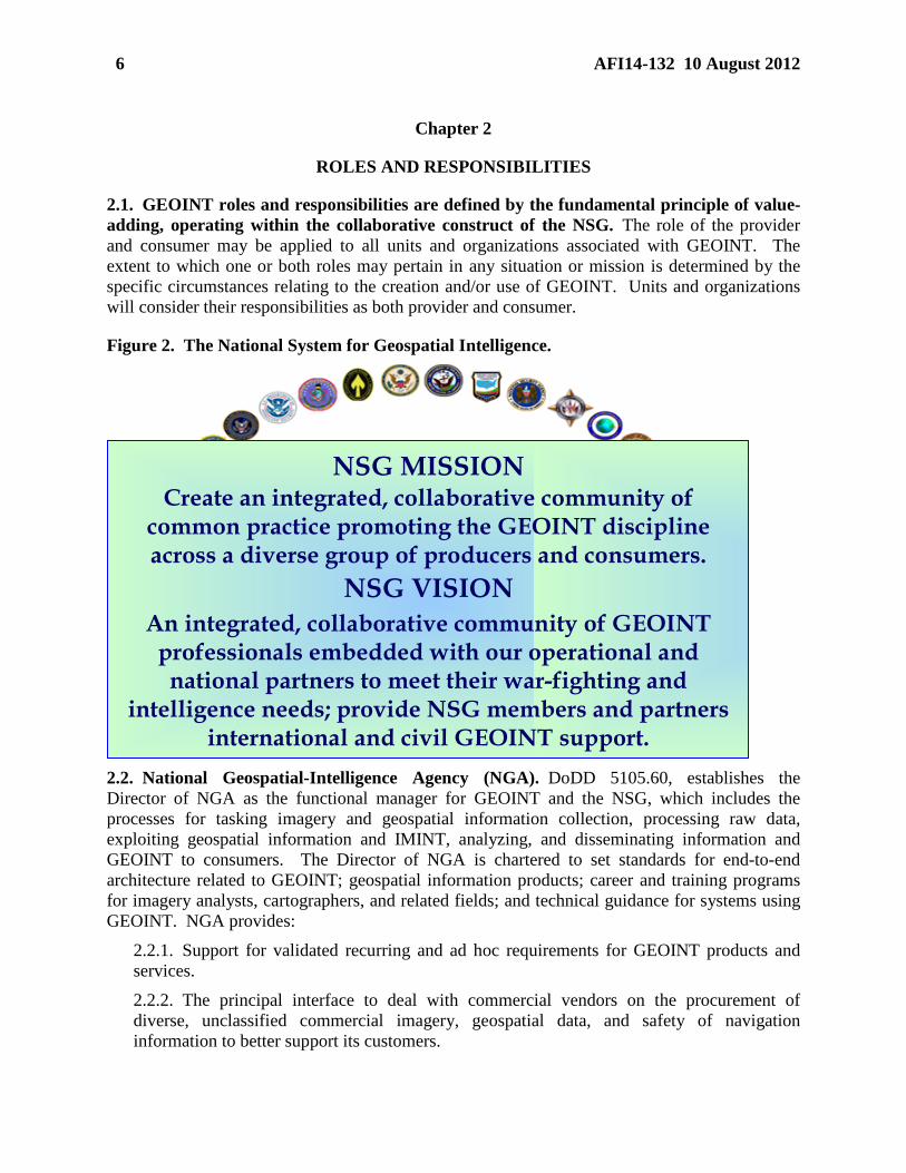
Figure 2. The National System for Geospatial Intelligence.
2.2. National Geospatial-Intelligence Agency (NGA). DoDD 5105.60, establishes the Director of NGA as the functional manager for GEOINT and the NSG, which includes the processes for tasking imagery and geospatial information collection, processing raw data, exploiting geospatial information and IMINT, analyzing, and disseminating information and GEOINT to consumers. The Director of NGA is chartered to set standards for end-to-end architecture related to GEOINT; geospatial information products; career and training programs for imagery analysts, cartographers, and related fields; and technical guidance for systems using GEOINT. NGA provides:
2.2.1. Support for validated recurring and ad hoc requirements for GEOINT products and services.
2.2.2. The principal interface to deal with commercial vendors on the procurement of diverse, unclassified commercial imagery, geospatial data, and safety of navigation information to better support its customers.
NSG MISSION
Create an integrated, collaborative community of common practice promoting the GEOINT discipline across a diverse group of producers and consumers.
NSG VISION
An integrated, collaborative community of GEOINT professionals embedded with our operational and national partners to meet their war-fighting and
intelligence needs; provide NSG members and partners international and civil GEOINT support.

AFI14-132 10 August 2012 7
2.2.3. Support for collaborative efforts with allies and coalition partners, IC agencies, DoD organizations, and other civil and government entities.
2.2.4. GEOINT strategic workforce planning and specific training for general and specialized tradecraft skills through the National Geospatial-Intelligence College.
2.2.5. NGA support teams (NST) are composed of a core cadre including geospatial analysts, imagery analysts, and staff officers, in direct support to COCOM joint intelligence operations centers (JIOCs) and service component major commands (e.g., MAJCOM A2, A3/5, A4/7, and 135 A8 staffs) which produce the full spectrum of NGA’s GEOINT capabilities and products.
2.2.6. Full reachback connectivity to the COCOM and NST to ensure total support of mission requirements.
2.3. Air Force (AF). The AF possesses unique warfighting capabilities and works with the other services to organize, train, equip, and coordinate their capabilities in order to operate as a joint force. The AF supports its own planning efforts as well as the planning efforts of the COCOMs it supports with GEOINT products, service-specific content, format, and media. AF must ensure all of its forces train with the appropriate range of GEOINT and have the appropriate systems to implement GEOINT. The AF also coordinates with the COCOMs on service-specific GEOINT program requirements. AF also coordinates with NGA to establish policy regarding roles and responsibilities for co-production of value-added data and management of distributed geospatial databases and libraries.
2.3.1. Deputy Chief of Staff, Intelligence, Surveillance, and Reconnaissance (AF/A2). AF/A2 serves as AF focal point for the end-to-end functional management of all AF ISR capabilities, to include GEOINT. AF/A2 will:
2.3.1.1. Interface with IC and combat support agency leaders, other Service Intelligence Chiefs and the Joint Staff, as required, to support AF GEOINT activities.
2.3.1.2. Comply with applicable IC, DoD, and joint GEOINT policy and directives.
2.3.1.3. Partner with other AF GEOINT stakeholders to establish a central GEOINT governance structure.
2.3.1.4. Establish and lead the AF GEOINT Enterprise (AFGE) to ensure AF GEOINT capabilities comply with published IC and DoD standards and ensure synergistic GEOINT operations in conjunction with members of the NSG.
2.3.1.5. Responsible for the effective integration of intelligence oversight into AF GEOINT activities.
2.3.1.6. Provide guidance to the AFGE, consisting of the AF MAJCOMs and Component Numbered Air Forces (C-NAFs), 25th Air Force (25 AF), the AF GEOINT Office (AFGO), and ACC/A2 geospatial intelligence components. AF/A2 delegates AF GEOINT roles and responsibilities as follows:
2.3.2. Deputy Chief of Staff, Intelligence, Surveillance, and Reconnaissance Capabilities Directorate (AF/A2C). AF/A2C will:

8 AFI14-132 10 August 2012
2.3.2.1. Formulate, interpret, coordinate, or recommend AF policy for targeting and GEOINT planning, training, and equipping matters. Provide functional and subject matter expertise for programming, budgeting, and execution matters.
2.3.2.2. Issue an annual memorandum to designate offices of OPRs for standing NSG forums and/or working groups. OPRs for ad hoc meetings of a recurring nature that are of limited duration will be designated on a case-by-case basis.
2.3.2.3. Oversee AF participation in the NSG Unified GEOINT Operations (UGO) process.
2.3.2.4. Serve as the AF GEOINT Functional Manager, the lead AF GEOINT representative within the IC and the NSG, and the primary AF interface with NGA.
2.3.2.5. Validate and prioritize, according to published NGA guidance, AF GEOINT user requirements submitted to NGA. For internal AF requirements, AF/A2CG will ensure the prioritization methodology is promulgated with the requirements data call.
2.3.2.6. Under direction of AF/A2D, oversee development of AF GEOINT doctrine, guidance and Tactics, Techniques and Procedures (TTP).
2.3.2.7. Direct, oversee, and support AF GEOINT modernization efforts, to include GEOINT collection, processing and production, and use of GEOINT information to ensure that AF GEOINT capabilities match the needs of the NSG.
2.3.2.8. Coordinate GEOINT plans, policy, and guidance with other Services, Joint Staff, NGA, USD (I), and Office of the Director of National Intelligence (ODNI) as necessary.
2.3.2.9. IAW DoDI 3115.15, coordinate with the Director of NGA, on any requirements for acquisition or exchange of commercial or foreign government-owned imagery-related remote sensing data and services.
2.3.2.10. Ensure AF and NSG GEOINT roles, responsibilities, dependencies, and equities are accurately reflected in all relevant AF and Joint Doctrine documents.
2.3.2.11. Address GEOINT issues impacting current and future AF capabilities. Validate and champion requirements through the AF corporate structure, as necessary.
2.3.2.12. Provide oversight and guidance on full-motion video (FMV) viewing, exploitation, and analysis tools including the Remotely Piloted Aircraft (RPA) Ground Control System (GCS) and the AF Distributed Common Ground System (DCGS).
2.3.2.13. Represent AF in space-based GEOINT ISR collection capability forums and provide subject matter expertise (SME) for National Security (DoD-IC), DoD Military, Civil government, and commercial space GEOINT systems.
2.3.2.14. Represent the AF/A2 in national, theater, and tactical forums and interface with national agencies, Joint Staff, and the Office of the Secretary of Defense (OSD) for AF equities in national space-based GEOINT ISR collection systems capabilities.
2.3.2.15. Coordinate departmental and IC space-based GEOINT ISR collection capabilities status, strategies, and plans.
2.3.2.16. Ensure AF/A2 ISR organizational involvement in research and development (R&D) efforts regarding space-based GEOINT ISR collection capabilities.
AFI14-132 10 August 2012 9
2.3.2.17. Maintain space and counter-space situational awareness of GEOINT ISR collection capabilities.
2.3.2.18. Provide SME inputs for integrated IC space-based GEOINT ISR collection capabilities documents, including system CONOPS, analysis of alternatives, functional solutions analysis, position/background papers, mission utility assessments/summaries, Joint Capabilities Integration and Development System (JCIDS) documentation and Congressional responses.
2.3.2.19. Serve as functional manager for GEOINT, and serve as the AF lead for GI&S with specific responsibilities articulated in AF Instruction (AFI) 14-205, Geospatial Information and Services.
2.3.2.20. Advocate for the service position or requirements to the Director of NGA, when foreign military sales cases involve articles and services that require NGA GEOINT data in compliance with DoD 5105.38-M, Security Assistance Management Manual (SAMM). 2.3.2.21. Establish policies and procedures to ensure processed data originating from AF managed collection and production systems is compliant with NSG-established standards for interoperability.
2.3.2.22. Co-Chair, with SAF/AQ representative, the AF GEOINT Capabilities Working Group Executive Element. The working group is chartered to provide AF decision-makers a comprehensive capabilities-based investment strategy for AF airborne GEOINT capabilities based upon AF, Joint, and National priorities.
2.3.3. Deputy Chief of Staff, ISR Strategy, Integration, and Doctrine Directorate (AF/A2D). AF/A2D will:
2.3.3.1. Serve as the OPR for AF GEOINT work force development. Represent AF equities within the NGA-led, Community GEOINT Training Council (CGTC).
2.3.3.2. Develop AF forces, structures, training, accession requirements and career paths to sustain an ISR career force with requisite GEOINT knowledge base to meet AF, MAJCOM, COCOM, and Combat Support Agency (CSA) requirements.
2.3.3.3. Function as signatory at all DoD, National, and AF GEOINT training and force management forums.
2.3.3.4. Incorporate guidance from USD(I) and the CGTC in the development and execution of GEOINT training.
2.3.3.5. IAW DoDI 3305.10, assemble, maintain, and forward to USD(I) a record of all GEOINT training requirements and programs under its cognizance.
2.3.4. Deputy Chief of Staff, ISR Resources Directorate (AF/A2R). AF/A2R will:
2.3.4.1. IAW DoDI 5000.56, formulate and advocate AF GEOINT guidance, specifically to oversee programming, resource allocation, and program evaluation for the National Intelligence Program (NIP), Military Intelligence Program (MIP) and other AF Program Objective Memorandum (POM) funding as appropriate in support of AF ISR.

10 AFI14-132 10 August 2012
2.3.4.2. Serve as the National Geospatial Intelligence Program (NGP) Program Element Monitor; primary advocate for the AF portion of the program; work with ACC and National Air and Space Intelligence Center (NASIC) staffs to prepare and submit various planning, programming, and budgeting documents that provide for the funding of AGI production and analysis, research and development, and acquisition.
2.3.4.3. Serve as Program Element Monitor for operationally fielded MIP-funded GEOINT capabilities in AF programs, including DCGS and the AF Targeting Enterprise.
2.3.4.4. Serve, as delegated by AF/A2, as the AF Battlespace Awareness Capabilities Portfolio Manager.
2.3.5. Deputy Chief of Staff, ISR Innovations Directorate (AF/A2Q). AF/A2Q will:
2.3.5.1. Provide operationally focused, quick-reaction efforts to apply GEOINT services and capabilities in support of Combatant Commanders (COCOMs), AF warfighters and our coalition partners.
2.3.5.2. Advocate a standards-based, user-focused approach to facilitate information fusion at all appropriate levels of warfare.
2.3.5.3. Advocate for new technologies or adaptation of current or planned ISR or GEOINT systems/components to support operational requirements and optimize end-user capabilities.
2.3.6. Deputy Chief of Staff, Air, Space and Information Operations, Plans and Requirements (AF/A3/5). AF/A3/5 will:
2.3.6.1. Provide policy and guidance to MAJCOM A3/5 offices to develop, monitor and assess GEOINT requirements to support all AF weapons and weapon system development and sustainment activities, as required.
2.3.6.2. Document, validate and submit requirements to AF/A2C for new, modified and existing GEOINT products needed to support weapon system research, development, test and evaluation (RDT&E) and sustainment.
2.3.6.3. Consider implications of shortfalls and changes in GEOINT products and/or services and assess their potential impact on performance of current and future weapons and weapon systems.
2.3.6.4. Participate in GEOINT supportability analysis for AF acquisition activities, as required.
2.3.7. Deputy Chief of Staff of the Air Force for Logistics, Installations, and Mission Support (AF/A4/7) will through HAF GIO guide the AF-wide implementation of the Installation Geospatial Information and Services (IGIS) Program.
2.3.8. Assistant Secretary of the Air Force for Acquisition (SAF/AQ). SAF/AQ will ensure, through consultation with the Director of NGA and AF/A2 that AF systems under development that use or produce GEOINT comply with GEOINT and interoperability standards established by NGA.

AFI14-132 10 August 2012 11
2.3.9. Deputy Undersecretary of the Air Force, International Affairs (SAF/IA). SAF/IA will coordinate with the Director of NGA and AF/A2, when foreign military sales cases involve articles and services that require NGA GEOINT data in compliance with DoD 5105.38-M.
2.3.10. Chief Warfighting Integration and Chief Information Officer (SAF/CIO A6). SAF/CIO A6 will provide architectural standards and policies that ensure synchronization and integration of the geospatial-enterprise.
2.3.11. Secretary of the Air Force General Counsel (SAF/GC) will provide legal review of GEOINT matters and operational proposals as required.
2.3.12. Judge Advocate General (AF/JA) provides functional oversight to legal offices responsible for advising the DoD intelligence components. AF/JA will also provide a legal review of GEOINT matters and operational proposals as required.
2.3.13. Air Force Flight Standards Agency (AFFSA). AFFSA will:
2.3.13.1. Serve as the AF OPR for the advocacy of Safety of Navigation requirements. (T-1) 2.3.13.2. Encourage MAJCOM input of GEOINT requirements that have the potential to impact instrument flight operations, landing systems, air traffic control, and airfield management of AF assets and installations. Consolidate those inputs and articulate them to AF/A2. (T-1) 2.3.13.3. Coordinate with AF/A2 to ensure the intelligence community remains apprised of emerging technologies that could require initial, programmatic or other sustained intelligence support. (T-1)
2.3.14. Air Force Weather Agency (AFWA). AFWA provides the forecast of worldwide weather and environmental conditions in support of defense and intelligence operations planning.
2.3.15. AF Academy Institute for Information Technology Applications (IITA) Geospatial Technology Center (GTC). The GTC will:
2.3.15.1. Test, evaluate, research, adapt, advance, and integrate new and existing geospatial technology solutions for the DoD. (T-3) 2.3.15.2. Identify low-cost geospatial technology solutions through RDT&E, education and training. (T-3)
2.3.16. 25th Air Force (25 AF). 25th AF conducts GEOINT operations within the AFGE and is responsible for AF GEOINT production. 25th AF will: (T-2)
2.3.16.1. Serve as lead element for integrating AF GEOINT production and capability development into the NSG (T-2)
2.3.16.1.1. Ensure the NSG has access to collected theater GEOINT data along with the authority to store and distribute that data, in compliance with CJCS Instruction 3340.02, Horizontal Integration of Warfighter Intelligence. (T-0)
2.3.16.2. Execute AF GEOINT processing, exploitation, dissemination (PED), and production and capability development; assist in the management of service-specific

12 AFI14-132 10 August 2012
tasking and resolution of collection issues, to include the emerging field of FMV GEOINT. (T-1) 2.3.16.3. Ensure appropriate representation at applicable technical and operational forums, as directed. (T-3) 2.3.16.4. Deleted.
2.3.16.5. Deleted.
2.3.16.5.1. Coordinate with gained ANG and AFRC units that are engaged in the production and/or dissemination of GEOINT. (T-2) 2.3.16.5.2. Assist ANG and AFRC units as appropriate to establish procedures and guidelines that ensure adherence to standards and continuity for production and dissemination. (T-2) 2.3.16.5.3. Assist ANG and AFRC units as appropriate to establish and/or manage training programs that ensure a smooth transition to wartime posture for these units and their personnel. (T-2)
2.3.16.6. Deleted.
2.3.16.7. Deleted.
2.3.16.8. Deleted.
2.3.16.9. Deleted.
2.3.16.10. Deleted
2.3.17. Air Force GEOINT Office (AFGO) will:
2.3.17.1. Represent AF at HQ NGA; provide integrated and coordinated GEOINT engagement among Air Staff and NSG, ASG, and NGA Functional Managers (FMs), as well as assist in integrating AF GEOINT policies, plans, programs, resources, capabilities, and RDT&E initiatives into the NSG.
2.3.17.2. Represent AF/A2 equities in NSG governance forums as directed by AF/A2CG; advocate AF policy, operations, systems, and TTP requirements for inclusion in NSG/NGA policies and standards guidelines, processes, and procedures.
2.3.17.3. Coordinate and lead AF review of NSG policy documents; facilitate AF FM approval of final recommendation.
2.3.17.4. Participate in AF programming forums to assist in validation and prioritization of AF GEOINT requirements.
2.3.17.5. Serve as AF NSG Mission Needs Manager to advocate and track AF requirements at NSG at FM reviews and deliberations.
2.3.17.6. Participate in NSG programming and evaluation processes to advocate AF GEOINT MIP/ NIP programs and requirements to NGA FMs and facilitate engagement between AF and NGA Program Managers (PM).
2.3.17.7. Serve as the AF UGO officer.
2.3.17.8. Represent AF GEOINT capabilities and TTPs to NGA FMs.

AFI14-132 10 August 2012 13
2.3.17.9. Document AF GEOINT analysis and production capabilities.
2.3.17.10. Reconcile UGO with AF GEOINT CBP.
2.3.17.11. Oversee AF integration into the NSG and working relationships with the ASG.
2.3.17.12. Represent AF collection capabilities at NGA/Source integration forums and facilitate ACC/NGA CBP discussions to enhance planning as well as to resolve issues.
2.3.17.13. Serve as AF point of contact (POC) at HQ NGA to facilitate, advocate, and track InnoVision future technology and NGA Acquisition/RDT&E processes, activities and investments.
2.3.17.14. Advise AF acquisition agencies on NGA-sponsored future GEOINT technology initiatives.
2.3.17.15. Coordinate and track NGA architectures, systems, sensors and tools acquisitions, and integration, enhancements, sustainment, and support initiatives.
2.3.17.16. Participate in NSG and ASG operational planning to ensure AF requirements and capabilities are addressed.
2.3.17.17. Integrate AF GEOINT operations and capabilities into the NSG and facilitate resolution of AF GEOINT mission issues.
2.3.17.18. Advocate for AF training needs and serve as the AF GEOINT tradecraft, training and development advisor to the HQ NGA staff.
2.3.18. NASIC will:
2.3.18.1. Provide GEOINT content-dominant data analysis of literal imagery from visible, synthetic aperture radar (SAR), spectral and thermal imagery as required to support scientific and technical intelligence and general military intelligence requirements. (T-1) 2.3.18.2. Perform Time-constrained Content Centric (TC3) and Content Dominant (CD) (Phase II and III) analysis on data collected by all DoD and IC Overhead Persistent Infrared (OPIR) sensors, DoD spaceborne sensors (to include TacSats and ORS), and airborne GEOINT sensors as required. (T-1) 2.3.18.3. Perform Phase II and III analysis on “non-literal” SAR, Spectral, and Thermal (SST) imagery data from National Technical Means and DoD sensors as required. (T-1) 2.3.18.4. Perform Phase II and III data analysis of non-literal SST data and ground moving target indicator (GMTI) forensics analysis for data collected by AF airborne (aircraft and RPA), other services and coalition airborne, and TacSat sensors as required. (T-1) 2.3.18.5. Perform time-dominant (TD) Phase I data analysis during R&D of new sensors for transition to AF DCGS or other AF, DoD, and IC ISR Enterprise nodes. Perform Phase I data analysis of AGI and OPIR sensors as required to meet IC and DoD intelligence needs. (T-3)

14 AFI14-132 10 August 2012
2.3.18.6. Perform computer-aided design (CAD) modeling from literal imagery sources to support science and technical intelligence requirements. (T-1) 2.3.18.7. Conduct R&D in OPIR and non-literal SST in collaboration with NGA. (T-3)
2.3.19. 480th Intelligence, Surveillance, and Reconnaissance Wing (480 ISRW). 480 ISRW will:
2.3.19.1. Operate the AF DCGS Enterprise and be a key exploiter and producer of AF GEOINT; articulate and formally codify requirements for consumable GEOINT products. (T-1)
2.3.19.1.1. Submit production requirements to 25 AF. (T-2) 2.3.19.1.2. Monitor, track, and provide feedback on products and other analyses provided to the wing. Produce and disseminate to 25 AF annual reports on utilization of GEOINT. Reports include analysis of quality and timeliness of GEOINT products and analyses with recommendations for improvement. (T-2)
2.3.19.2. Participate in requisite AF GEOINT working groups and other forums that facilitate advancement of the discipline. (T-2)
2.3.20. 70th Intelligence, Surveillance, and Reconnaissance Wing (70 ISRW). The 70 ISRW will:
2.3.20.1. Deleted.
2.3.20.2. Submit GEOINT production requirements to 25 AF. Submit an annual production plan to the AF UGO Officer for inclusion in the AF production plan. (T-2) 2.3.20.3. Participate in requisite AF GEOINT working groups and other forums that facilitate advancement of the discipline. (T-2)
2.3.21. Other 25 AF Units will:
2.3.21.1. Articulate and formally codify requirements for consumable GEOINT products. (T-2)
2.3.21.1.1. Submit GEOINT production requirements to 25 AF. (T-2) 2.3.21.1.2. Monitor, track, and provide feedback on products provided to the unit. Produce and disseminate to 25 AF annual reports on GEOINT utilization. Reports should include analysis of quality and timeliness of GEOINT products and analyses with recommendations for improvement. (T-2)
2.3.21.2. As appropriate, participate in requisite AF GEOINT working groups and other forums which facilitate advancement of the discipline. (T-2)
2.3.22. Air Combat Command (ACC). ACC organizes, trains, equips and presents Combat Air Force (CAF) GEOINT forces and capabilities to conduct ISR for combatant commanders. ACC will coordinate with Air Force Space Command/A2 on all GEOINT matters involving DoD Space-based ISR assets.
2.3.22.1. ACC Director of Intelligence (ACC/A2). ACC/A2 will:
2.3.22.1.1. Serve as the CAF lead for AF GEOINT CBP, intelligence supportability, sustainment, and intelligence integration.
AFI14-132 10 August 2012 15
2.3.22.1.2. Assist with developing national technical and procedural standards for AF targeting, imagery transmission to the cockpit, and certification of onboard point-positioning capabilities.
2.3.22.1.2.1. Promulgate, in concert with Air Force Materiel Command (AFMC), Air Education and Training Command (AETC), and ACC/A2, standards in joint and service TTPs and training programs for aircrews and Air Operation Centers.
2.3.22.1.3. Define operational requirements for and monitor AF GEOINT requirements for fielded CAF weapon systems. Coordinate with AFMC and other MAJCOMs as required.
2.3.22.1.4. Coordinate with AFISRA to ensure CAF CBP and PED integration and modernization issues are addressed.
2.3.22.1.5. Participate in AF GEOINT enterprise activities and planning; assess effectiveness, evaluate shortfalls.
2.3.22.1.6. Advocate CAF GEOINT support requirements.
2.3.22.1.7. Execute AF GEOINT PED, production and capability development; address tasking and collection issues.
2.3.22.1.8. Coordinate with the operating and implementing commands to ensure capability planning, PED integration, and modernization issues are addressed.
2.3.22.1.9. Organize, train, equip, and present AF GEOINT forces to conduct ISR for COCOMs.
2.3.22.2. Air Force Targeting Center (AFTC). AFTC will:
2.3.22.2.1. Produce and deliver timely, tailored targeting and geospatial intelligence, combat identification products, strategic analysis, and unit support enabling the full spectrum of military operations. (T-1) 2.3.22.2.2. As one of two AF production centers for GEOINT, manage the production of a wide variety of products as a reachback organization for the C-NAFs in support of their peacetime and wartime operations. These products include Controlled Image Base (CIB), Geospatial Product Library (GPL), Aim Point Graphics (APG), Domestic Range Imagery, Thunderbird demonstrations support, battle damage assessments and Target Materials (TMs). These TMs include, but are not limited to, Joint Desired Point of Impact Graphics, Joint Air-to-Surface Standoff Missile (JASSM) Terminal Area Models (TAM), Conventional Air Launched Cruise Missile (CALCM) target graphics and Collateral Damage Estimation (CDE) graphics. (T-2) 2.3.22.2.3. Direct the GEOINT production and dissemination efforts of subordinate ANG and AFRC units that support the AETC Enterprise. (T-2) 2.3.22.2.4. Assist ANG and AFRC units as appropriate to establish and manage procedures, guidelines and training programs that ensure adherence to standards and continuity for production and dissemination. (T-2)

16 AFI14-132 10 August 2012
2.3.22.2.5. Through ACC/A2, provide targeting perspective to AF/A2CG to formulate AF GEOINT policies and procedures that will ensure continuity and standardization across the AF GEOINT community. (T-2) 2.3.22.2.6. IAW AFI 14-126, Target Coordinate Mensuration Training, Qualification and Certification, manage the Air Force’s Precise Point Positioning Program (AFP4) overseeing training, qualification, and certification. Implement the AFP4 which includes precise positioning mensuration (PPM) training and certification for CAF personnel. (T-2) 2.3.22.2.7. Ensure GEOINT personnel meet the training standards agreed upon through the Utilization and Training Workshop (U&TW) process, as delineated in Chapter 5, AFI 36-2201, Air Force Training Program. (T-2)
2.3.23. Air Force Space Command (AFSPC). AFSPC organizes, trains, equips and presents DoD Space-based GEOINT forces and capabilities to conduct ISR for combatant commanders. AFSPC will coordinate with ACC on all GEOINT matters involving ISR as CAF lead AF GEOINT CBP, intelligence supportability, sustainment, and intelligence integration.
2.3.23.1. AFSPC Director of Intelligence, Surveillance and Reconnaissance (AFSPC/A2). AFSPC/A2 will:
2.3.23.1.1. Serve as the primary point of contact for all issues regarding DoD space-based ISR assets.
2.3.23.1.2. Will maintain close coordination with AFMC, SMC, 25 AF and ACC/A2, on DoD Space-based ISR standards and in joint and service TTPs and training programs involving DoD Space-based ISR platform’s PCPAD, and overall command and control of each asset.
2.3.23.1.3. Develop and document functional GEOINT requirements. Functional requirements include requirements for new or modified GEOINT products, as well as requirements for existing GEOINT products to support weapon system research, development, test, initial fielding and sustainment. Functional requirements are defined as an output of systems-level engineering analysis conducted on warfighter performance requirements. Implementing command assesses the availability of NGA resources against weapon system performance requirements and develops production requirements to address the capability gaps between development needs and NGA resources.
2.3.24. AETC is responsible for the holistic approach to training and education for AF personnel to understand, produce, and use GEOINT. AETC will:
2.3.24.1. Incorporate MAJCOM requirements into course development processes and provide formal and continuation training courses IAW AFI 36-2201.
2.3.24.2. Provide specialized precision mensuration training courses when required to meet specific personnel training needs, as determined by the Air Force Specialty Code Career Field Manager (CFM).

AFI14-132 10 August 2012 17
2.3.24.3. Evaluate student performance ex post facto to determine if training being provided is meeting established training standards and students are able to perform the tasks required.
2.3.24.4. Maintain and adjust formal training courses to meet evolving requirements as developed by MAJCOMs, C-NAFs, and COCOMs (where suitable).
2.3.24.5. Recommend changes to precision training based on course evaluations and student post-graduate reviews to better meet established training requirements.
2.3.25. Air Force Materiel Command (AFMC) develops and documents functional GEOINT requirements for all non-Air Force Space Command weapon systems. Functional requirements include requirements for new or modified GEOINT products, as well as requirements for existing GEOINT products to support weapon system research, development, test, initial fielding and sustainment. Functional requirements are defined as an output of systems-level engineering analysis conducted on warfighter performance requirements. AFMC assesses the availability of NGA resources against weapon system performance requirements and develops production requirements to address the capability gaps between development needs and NGA resources. Establishes and maintains liaison with the AFGO at NGA, in coordination with AF/A2, as a principal means of routine technical exchange with the NSG on matters of weapons and weapon systems GEOINT dependencies. AFMC will:
2.3.25.1. Ensure integration and implementation of AF GEOINT strategy, policy, planning and programming into AFMC CBP RDT&E and sustainment activities.
2.3.25.2. Provide, develop, monitor and assess AF GEOINT support to all AFMC RDT&E and sustainment activities throughout their lifecycle.
2.3.25.3. Embed GEOINT supportability analysis into AF acquisition activities to ensure early and sustained support throughout the lifecycle of systems, to include the projection of GEOINT costs as a Life Cycle Cost Estimate.
2.3.25.4. Serve as the lead for developing, managing, and resolving AFMC acquisition-related AF GEOINT requirements and shortfalls developed throughout the acquisition life-cycle process.
2.3.25.5. Assess shortfalls and changes in AF GEOINT community processes and products for impact to RDT&E, modernization and sustainment; report impact of changes to program offices, lab activities and responsible OPRs.
2.3.25.6. Develop, document, and submit requirements for new, modified, and existing production of GEOINT products in support of AF RDT&E and sustainment.
2.3.25.7. Establish AFMC policies and procedures to ensure processed data originating from AFMC-managed collection and production systems is compliant with NSG-established standards for interoperability.
2.3.25.8. Identify classified information and provide security classification guides approved by authorized original classification authorities for all AF GEOINT data, sensors, and systems developed within their organizations.
2.3.26. Aeronautical Systems Center Capabilities Integration Directorate (ASC/XR) will:

18 AFI14-132 10 August 2012
2.3.26.1. Serve as lead for CBP while user requirements are under development.
2.3.26.2. Ensure identification of key GEOINT product and service dependencies in the RDT&E of current and future AF weapons through coordination with relevant PMs.
2.3.26.3. Ensure comprehensive GEOINT planning and integration into ASC activities.
2.3.27. Air Armament Center (AAC). AAC will:
2.3.27.1. Ensure identification of key AF GEOINT product and service dependencies in the RDT&E of current and future AF weapons through coordination with relevant Program Managers.
2.3.27.2. Coordinate AF weapon GEOINT dependencies with the DoD Joint Technical Coordinating Group for Munitions Effectiveness (JTCG/ME) to ensure relevant weapon performance data and characteristics are obtained, and Joint Munitions Effectiveness Manual methodologies are properly configured to enable operational effectiveness and collateral damage estimation, and post-attack assessment.
2.3.28. Other MAJCOMs and C-NAF. Through their senior appointed AF GEOINT representative, all MAJCOMs and C-NAFs will coordinate with AF/A2C and the AFGO to effectively and efficiently work organization and subordinate-level GEOINT issues through applicable channels. All MAJCOM and C-NAF SIOs will (if applicable):
2.3.28.1. Represent organization GEOINT mission activities as directed by AF/A2C.
2.3.28.2. Review and implement AF GEOINT policy, guidance, and standards.
2.3.28.2.1. Prepare and issue supplements to higher headquarters GEOINT publications and directives.
2.3.28.2.2. Coordinate command responses to higher headquarters GEOINT data calls, tasking, and requests for information.
2.3.28.3. Participate in AF GEOINT enterprise activities and planning; assess effectiveness, evaluate shortfalls, and provide feedback to AF/A2C.
2.3.28.4. Organize, train, equip, and present forces to COCOMs and DoD to execute assigned GEOINT missions; develop or request development of GEOINT capabilities and applications that provide direct mission planning and execution in support of warfighter missions; develop plans to integrate GEOINT capabilities into assigned ISR forces.
2.3.28.5. Support AF/A2 and AF/A3 PPBE processes; develop organizational procedures for unit submissions IAW AF/A2 timelines.
2.3.28.6. Ensure effective and efficient integration of AF GEOINT capabilities in assigned missions/weapon systems and coordinate with ACC to resolve CBP, Planning and direction, Collection, Processing and exploitation, Analysis and production, and Dissemination (PCPAD), and modernization issues.
2.3.28.7. Identify requirements to AF/A2C and work with appropriate AF POC concerning modernization and acquisition initiatives IAW established procedures.
2.3.28.8. Identify force GEOINT training and develop requirements to AF/A2C.

AFI14-132 10 August 2012 19
2.3.28.9. Develop plans, policies, standards, and procedures pertaining to command GEOINT activities.
2.3.28.10. Ensure GEOINT points of contact establish and maintain GI&S distribution accounts and submit routine and automatic distribution requests to Defense Logistics Agency, as necessary.
2.3.28.11. Coordinate with subordinate units, MAJCOM staff, Air Staff, COCOM, and other commands or services concerning command GEOINT requirements, deficiencies, and recommended solutions.
2.3.28.12. Liaise with NGA, National Reconnaissance Office (NRO), ACC, COCOM, AFMC, and relevant contractors to establish and maintain for their respective MAJCOM GEOINT capabilities.
2.3.28.13. Integrate emerging technology, adhering to community standards where possible, into MAJCOM GEOINT plans/architectures; provide expertise to MAJCOM planning, programming, and budgeting process.
2.3.28.14. As required, prepare GI&S Annexes (Annex M) to Operation Plans (OPLANs) and Concept Plans (CONPLANs) according to AFMAN 10-401, Operation Plan and Concept Plan Development and Implementation, and supported COCOM directives. Ensure dissemination of digital materials via the GPL supersede and replace traditional bulk hardcopy materials currently in War Reserve Stock (WRS).
2.3.28.15. Identify, request and maintain on GPL, appropriate GI&S stocks/data to support OPLAN or CONPLAN tasking.
2.3.28.16. Conduct WRS planning. Where applicable, identify WRS requirements for movement in the Time Phased Force and Deployment Data Listing (TPFDD) and the OPLAN or CONPLAN Logistics Annex.
2.3.28.17. Establish procedures to ensure sufficient GI&S items are available to sustain routine operations and ensure adequate re-supply. Issue maps, charts, digital GI&S data, and related items when required. Maintain accessibility to pertinent NGA instructions, manuals and catalogs.
2.3.28.18. Actively coordinate with command operations, plans, training, logistics, requirements, inspection, and intelligence staffs to ensure doctrine, strategy, tactics, logistics, and RDT&E efforts adequately address GI&S functional requirements.
2.3.28.19. Assist in the creation, development and fielding of new procedures and techniques to facilitate AF-generated changes such as the GPL development.
2.3.28.20. Ensure GEOINT plans/architectures are funded, as applicable.
2.3.28.21. Ensure data/product reviews are accomplished and responses to all NGA GI&S product reviews are routed through the chain of command to AF/A2C for AF position.
2.3.28.22. Participate in annual AF GEOINT conferences, periodic special GEOINT meetings and the AF GEOINT Community of Interest, to address critical GEOINT matters of mutual concern.

20 AFI14-132 10 August 2012
2.3.28.23. Ensure subordinate units are aware of, and comply with AF and Joint Chiefs of Staff (JCS) policy regarding use of World Geodetic System (WGS) and other datum.
2.3.28.24. Provide GEOINT support to all gained Air Reserve Components (ARC) [ANG and AFRC] IAW AFI 10-301, Responsibilities of Air Reserve Component (ARC) Forces.
2.3.29. Units. Units will consider their responsibilities as both provider and consumer and ensure their combined operations, intelligence and logistics GEOINT requirements are consolidated via a single unit-level OPR and articulated through appropriate command channels. Units will:
2.3.29.1. Support periodic higher headquarters solicitation of GEOINT support requirements with responses (to include negative responses) identifying requirements for each of the three components of GEOINT particular to the individual unit’s mission(s); specified in volumetric terms of GEOINT support products and/or services, necessary currency and/or timeliness, minimum acceptable level of detail, geographic area(s) of coverage, transmission media, and data formats. (T-2) 2.3.29.2. Identify unit activities and/or processes that manipulate GEOINT to add value to the form in which it was originally received and/or to transform it into a new product or service, which can then be made available to a broad range of addition potential users resident in the NSG and the ASG. (T-2) 2.3.29.3. Identify processes in unit activities and/or missions which are actually or potentially GEOINT-dependent and which are currently unsupported or underserved; to include such activities and missions as targeting (e.g., physical and functional characterization of tasked targets for late-stage target development, weaponeering, collateral damage estimation, mission planning, and assessment), flight operations planning (e.g., mission visualization for rehearsal and crew training and/or Safety-of-Flight), and resource/facility management/protection (e.g., geospatial datasets for use in CAD systems by civil engineers, local, and peripheral terrain and inter-visibility analysis by security forces). (T-2) 2.3.29.4. Participate in operations-oriented, end-user/producer technical exchange meetings and working groups, as applicable to the unit mission, to ensure relevance and focus in the ongoing development of GEOINT products and services by the NSG and ASG. (T-2) 2.3.29.5. Adhere to mandated unit-level training standards to ensure effective understanding of principles of relevant GEOINT products, services and TTPs for their application to particular unit activities and missions. (T-2) 2.3.29.6. Translate principles and processes contained in AF and Joint GEOINT doctrine into local TTPs pertaining to all unit activities and missions that produce, provide or consume GEOINT products and/or services. (T-2) 2.3.29.7. Establish local procedures for the capture of evolving GEOINT product and/or service support requirements associated with unit activities and missions. (T-3) 2.3.29.8. Establish local procedures for capture, cataloging and transmission of GEOINT and/or value-added GEOINT created in the conduct of unit activities and missions. (T-3)

AFI14-132 10 August 2012 21
2.3.29.9. Maintain situational awareness of the status of submitted GEOINT product and/or service requirements and collaborate with end users to ensure responses meet their intelligence needs. (T-2)
LARRY D. JAMES, Lt Gen, USAF Deputy Chief of Staff, Intelligence, Surveillance and Reconnaissance

22 AFI14-132 10 August 2012
Attachment 1
GLOSSARY OF REFERENCES AND SUPPORTING INFORMATION
References AFPD 14-1, Air Force Intelligence Planning and Operations, 1 June 1999
AFI 10-301, Responsibilities of Air Reserve Component (ARC) Forces, 16 August 2006
AFI 14-104, Oversight of Intelligence Activities, 23 April 2012
AFI 14-126, Target Coordinate Mensuration Training, Qualification and Certification, 14 March 2013
AFI 36-2201, Air Force Training Program, 15 September 2010
DoD Directive 5105.60, National Geospatial-Intelligence Agency (NGA), July 29, 2009
DoD Instruction 3115.15, Geospatial Intelligence (GEOINT), December 6, 2011
DoD Instruction 3305.10, DoD Geospatial Intelligence (GEOINT) Training, December 22, 2006
DoD Instruction 5000.56, Programming Geospatial-Intelligence (GEOINT), Geospatial Information and Services (GI&S), and Geodesy Requirements for Developing Systems, July 9, 2010
DoD Instruction 5105.38-M, Security Assistance Management Manual (SAMM), October 3, 2003
DoD 5240.1-R, Procedures Governing the Activities of DoD Intelligence Components That Affect United States Persons, December 1, 1982
Adopted Forms AF Form 847, Recommendation for Change of Publication, 22 September 2009
Abbreviations and Acronyms 25 AF—25th Air Force
AAC—Air Armament Center
ACC—Air Combat Command
AD—Active Duty
AF—Air Force
AFFSA—Air Force Flight Standards Agency
AFGE—AF GEOINT Element
AFGO—AF GEOINT Office
AFMC—Air Force Materiel Command
AFRC—Air Force Reserve Command
AFTC—Air Force Targeting Center
AFWA—Air Force Weather Agency

AFI14-132 10 August 2012 23
AGI—Advanced Geospatial Intelligence
ANG—Air National Guard
APG—Aim Point Graphic
ASC—Aeronautical Systems Center
ASG—Allied System for Geospatial Intelligence
C-NAF—Component Numbered Air Force
CAD—Computer-Aided Design
CAF—Combat Air Forces
CBP—Capabilities-Based Planning
CD—Content Dominant
CDE—Collateral Damage Estimation
CFM—Career Field Manager
CGTC—Community Geospatial-Intelligence Training Council
CIB—Controlled Image Base
COA—Course of Action
COCOM—Combatant Command
COE—Consequences of Execution
CSA—Combat Support Agency
DAF—Department of the Air Force
DCGS—Distributed Common Ground System
DCS—Deputy Chiefs of Staff
DoD—Department of Defense
DNI—Director of National Intelligence
DRU—Direct Reporting Unit
ESC—Electronic Systems Center
FM—Functional Manager
FOA—Field Operating Agency
GCS—Ground Control Station
GEOINT—Geospatial-Intelligence
GI&S—Geospatial Information & Services
GPL—Geospatial Product Library
GWG—Geospatial Intelligence Standards Working Group

24 AFI14-132 10 August 2012
HAF—Headquarters Air Force
HAF GIO—Headquarter Air Force Geo Integration Office
IC—Intelligence Community
IITA—Institute for Information Technology Applications
IMINT—Imagery Intelligence
ISR—Intelligence, Surveillance, and Reconnaissance
IAW—In accordance with
JCIDS—Joint Capabilities Integration and Development System
JIOC—Joint Intelligence Operations Center
JTCG/ME—Joint Technical Coordinating Group for Munitions Effectiveness
MAJCOM—Major Command
MIP—Military Intelligence Program
MRTP—Mission Ready Training Program
NASIC—National Air and Space Intelligence Center
NGA—National Geospatial-Intelligence Agency
NGP—National Geospatial Intelligence Program
NIP—National Intelligence Program
NSG—National System for Geospatial Intelligence
NST—NGA Support Teams
NTM—National Technical Means
ODNI—Office of the Director of National Intelligence
OPIR—Overhead Persistent Infrared
OPR—Office of Primary Responsibility
ORS—Operationally Responsive Space
OSD—Office of the Secretary of Defense
PCPAD—Planning and direction, Collection, Processing and exploitation, Analysis and production, and Dissemination
PED—Processing, Exploitation, and Dissemination
POC—Point of Contact
POM—Program Objective Memorandum
PPBE—Planning, Programming, Budgeting and Execution
R&D—Research and Development
RDS—Records Disposition Schedule
AFI14-132 10 August 2012 25
RDT&E—Research, Development, Test and Evaluation
RPA—Remotely Piloted Aircraft
SAR—Synthetic Aperture Radar
SIO—Senior Intelligence Officer
SME—Subject Matter Expert
SON—Safety of Navigation
SST—SAR, Spectral, and Thermal
T-1—Tier 1
T-2—Tier 2
T-3—Tier 3
TMs—Target Materials
TC3—Time-constrained Content-Centric
TPFDD—Time Phased Force and Deployment Data
TTP—Tactics, Techniques and Procedures
U&TW—Utilization and Training Workshop
UGO—Unified GEOINT Operation
USAF—United States Air Force
USC—Unites States Code
USD—Under Secretary of Defense
WGS—World Geodetic System
WRS—War Reserve Stock
Terms Advanced Geospatial Intelligence (AGI)—Refers to the technical, geospatial, and intelligence information derived through interpretation or analysis using advanced processing of all data collected by imagery or imagery-related collection systems. Also known as imagery-derived measurement and signature intelligence. (JP 2-03)
Geospatial Intelligence (GEOINT)—The exploitation and analysis of imagery and geospatial information to describe, assess, and visually depict physical features and geographically referenced activities on the Earth. Geospatial intelligence consists of imagery, imagery intelligence, and geospatial information. (JP 2-03)
Geospatial Information and Services (GI&S)—The collection, information extraction, storage, dissemination, and exploitation of geodetic, geomagnetic, imagery (both commercial and national source), gravimetric, aeronautical, topographic, hydrographic, littoral, cultural, and toponymic data accurately referenced to a precise location on the Earth’s surface. Geospatial

26 AFI14-132 10 August 2012
services include tools that enable users to access and manipulate data, and also include instruction, training, laboratory support, and guidance for the use of geospatial data. (JP 2-03)
Imagery Intelligence (IMINT): —The technical, geographic, and intelligence information derived through the interpretation or analysis of imagery and collateral materials. (JP 203)
Tier 1 (T-1)—Non-compliance puts Airmen, commanders or the USAF strongly at risk of mission or program failure, death, injury, legal jeopardy or unacceptable fraud, waste or abuse. T-1 waiver requests may be granted at the MAJCOM/CC level, but may not be delegated lower than MAJCOM Director, with the concurrence of the publication's approving official. (AFI 33-360)
Tier 2 (T-2)—Non-compliance has the potential to create moderate risk of mission or program degradation or failure, injury, legal jeopardy or unacceptable fraud, waste or abuse. Waivers may be granted at the MAJCOM/CC level, but may not be delegated lower than MAJCOM Director. (AFI 33-360)
Tier 3 (T-3)—Non-compliance has a relatively remote potential to create risk of mission or program degradation or failure, injury, legal jeopardy or unacceptable fraud, waste or abuse. Waivers may be granted at the Wing/DRU/FOA/CC level. (AFI 33-360)